Embed Size (px)
Citation preview
CRITICAL DRIVERS FOR WASTEWATER MANAGEMENT IN THE GREAT BAY ESTUARY WATERSHED: WATER QUALITY AND HABITAT PROTECTION, AND
SUSTAINABLE GROWTH MANAGEMENT
Betsy Shreve-Gibb,* Aaron Weieneth,** Jessica Strauss,** and Nathan Henderson** *Metcalf & Eddy, Inc. 701 Edgewater Drive Wakefield, MA 01913
** Metcalf & Eddy, Inc.
ABSTRACT Increasing population growth resulting in substantial land development is contributing to increased wastewater generation and some increased nutrient loadings to Great Bay in New Hampshire. Seventeen wastewater treatment plants discharge to the Great Bay watershed. Some of the WWTP discharges do not meet current limits and others are not able to meet future limits, which are expected to include nitrogen and phosphorus. Initial proposals for wastewater management focused on a regional centralized collection system with local or regional treatment and subsequent offshore discharge to the Gulf of Maine. While this would have allowed the communities the ability to meet effluent discharge limits, there was significant concern on the part of the communities and other stakeholders regarding the potential for extended centralized wastewater collection systems to generate secondary growth, result in significant reduction in local groundwater levels and reduced aquatic base flow in receiving waters in the project area, and transfer a water quality problem from the estuary to the Gulf of Maine. Thus, alternative wastewater management strategies were developed. These alternatives included upgrading existing WWTPs and discharging treated effluent to existing surface water discharge locations, treating wastewater locally and discharging to local land application sites, and requiring decentralized wastewater treatment and local discharge for a significant portion of all new growth. The study addresses the key concerns of reducing nutrient loading, while encouraging sustainable development and natural resource protection. KEYWORDS Water Quality, Habitat Protection, Nutrient Loading, Decentralized Wastewater Management, Groundwater Recharge, Smart Growth INTRODUCTION Background The Great Bay Estuary, known as the “jewel of the New Hampshire Seacoast,” is located in one of the fastest growing regions of New England. The estuary’s watershed encompasses 44 communities in New Hampshire that have seen almost a 40 percent increase in population since
2800
WEFTEC®.06
Copyright 2006 Water Environment Foundation. All Rights Reserved©
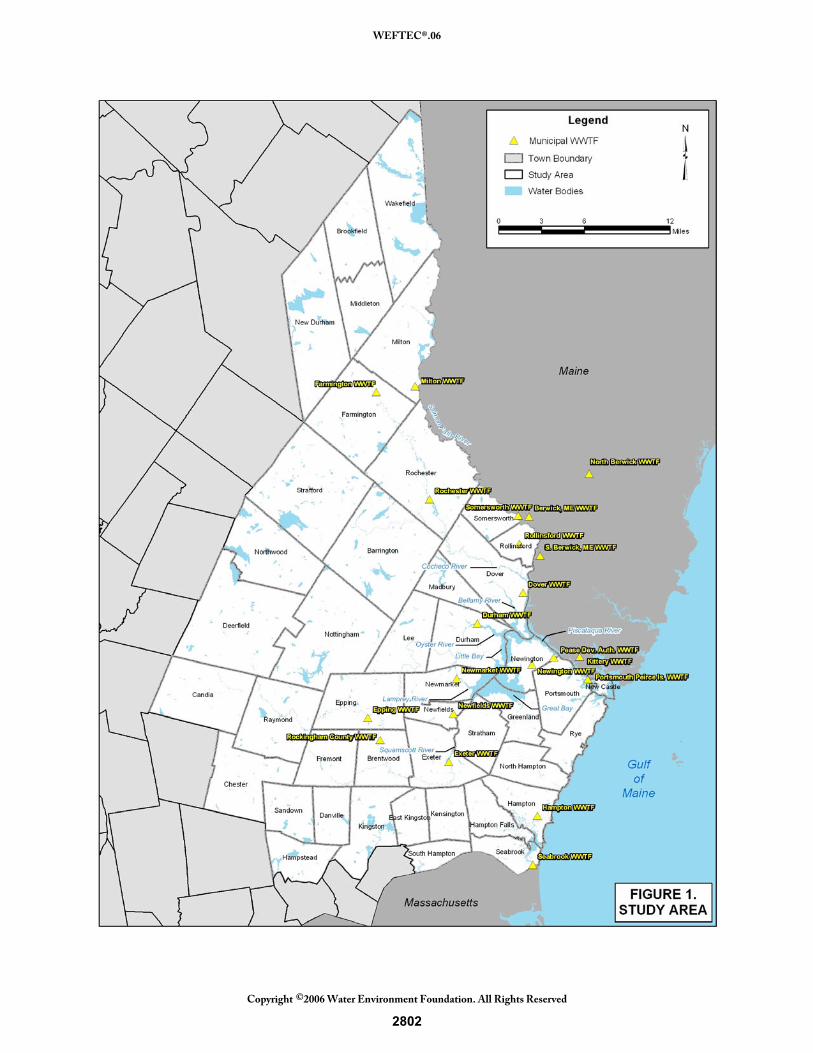
1980. The estuary is tidally dominated and provides habitat to critical sensitive resources including shellfish, a host of fisheries, and coastal marshland. There is serious concern among key stakeholders that these resources are being threatened by significant population growth, the associated demand on resources, and the resulting increase in pollutant generation, particularly wastewater pollutants. Seventeen of the 44 communities have municipal wastewater treatment facilities (WWTFs) that discharge to the Great Bay Estuary watershed (see Figure 1). The discharges from these plants, in addition to stormwater and nonpoint discharges, have contributed to increased nutrient loading in the estuary (NHEP, 2003). Many of the WWTFs in the study area discharge to receiving waters with a very low level of dilution available. Consequently, high level of removal of various pollutants is required. There is recognition that current regulatory trends will lead to more stringent limits of pollutants, particularly phosphorus and nitrogen, discharged from the WWTFs. The New Hampshire Estuary Project 2003 Report, State of the Estuaries, notes that nitrogen concentrations in the Great Bay have increased over time, although not yet to the level at which there are significant effects. The report sets a goal, but is not mandated by State policy, of maintaining inorganic nutrients in area waters at 1998-2002 levels. Future effluent limits on nutrients and other parameters are therefore under discussion. It was the expectation of more stringent limits, in conjunction with the potential need to expand the capacity of the WWTFs to accommodate future population growth, that provided the impetus for the study of wastewater management alternatives. In 1999, two of the regional planning commissions in the project area took the lead in exploring a regional effluent discharge concept. The document they produced, which included an inventory of existing wastewater treatment facilities’ needs and issues and some background information, resulted in the recommendation to undertake a feasibility study for a regional treated effluent system and implementation of sustainable, smart-growth planning and management principles. State legislation (Senate Bill 70) was passed to create a study commission that would oversee the feasibility study. The Great Bay Estuary Commission was created to work with the state Department of Environmental Services (DES) to study the options for wastewater treatment and disposal, protect estuary habitat, and create a watershed district. While the initial premise of the legislation was to study the feasibility of a regional discharge system, there was significant concern among stakeholders that extension of sewers and increases in plant capacity would exacerbate growth resulting in undesirable secondary effects, increased pressure on drinking water supplies, and increased discharge of pollutants that would further threaten sensitive coastal and aquatic resources. Of particular concern to the commercial fishing industry were possible effects of an offshore discharge on some species of fish which are already experiencing population decline in the Gulf of Maine. Because of these concerns, the scope of the feasibility study was expanded to include other alternatives such as the upgrading of the existing WWTFs and discharging to existing surface water discharges, establishing decentralized wastewater treatment and discharge, and providing local treatment and subsequent groundwater recharge.
2801
WEFTEC®.06
Copyright 2006 Water Environment Foundation. All Rights Reserved©
2802
WEFTEC®.06
Copyright 2006 Water Environment Foundation. All Rights Reserved©
Purpose of Study The objectives of the wastewater management feasibility study are to develop and evaluate a range of wastewater management alternatives based on an assessment of current conditions with regard to land use patterns and population growth, treatment and flow capacity of the WWTFs, water quality in the tributaries of the estuary and in the Gulf of Maine, stream flow conditions in the tributaries, groundwater levels, and critical aquatic and coastal resources. The evaluation is being conducted in light of the state and local efforts to encourage sustainable growth management policies; preserve the aesthetic, ecological and recreational value of the estuary; and protect the economic value of the state’s shellfishing and fishing industries in the context of the political and institutional realities of the 44 communities. Review and assessment of pollutant contribution from several WWTFs in the State of Maine is under separate review by that state. Efforts to share information are ongoing.
METHODOLOGY
Data Collection and Characterization of Existing Conditions Significant data was collected from the numerous sources at multiple levels. Sources contacted included regulatory agencies (such as DES, New Hampshire Office of Energy and Planning, USGS, USEPA), the three regional planning agencies in the study area, local communities, academic institutions (such as University of New Hampshire and Jackson Estuarine Laboratory) and public interest groups (such as Conservation Law Foundation and the Society for Protection of New Hampshire Forests). Data collected included the following:
• Existing population, population projections and seasonal trends • Current land uses and density of development • Current zoning regulations and mapping • Wastewater treatment facilities locations, service areas, treatment processes, capacities,
septage flows, outfall locations, dilution levels, permit limits, compliance status, capital and operation and maintenance costs
• Wastewater treatment facilities plans • Collection system mapping • Inter-municipal agreements for wastewater and septage • Receiving water quality data (monitoring data, 303d lists and TMDL requirements) • Aquatic resource abundance and health • Environmental mapping (soils, land use, wetlands, floodplains, conservation lands, rare
and endangered species, shellfish resources) • Stream flow data
In addition to data sources noted above, several public meetings were conducted throughout the study area to obtain direct input from local residents and other stakeholders. Using this information, projections of future conditions were made for two planning periods: 2025 and 2055. These projections allowed for establishing future baseline conditions to provide a basis for developing alternatives and identifying potential impacts of implementing the alternatives.
2803
WEFTEC®.06
Copyright 2006 Water Environment Foundation. All Rights Reserved©
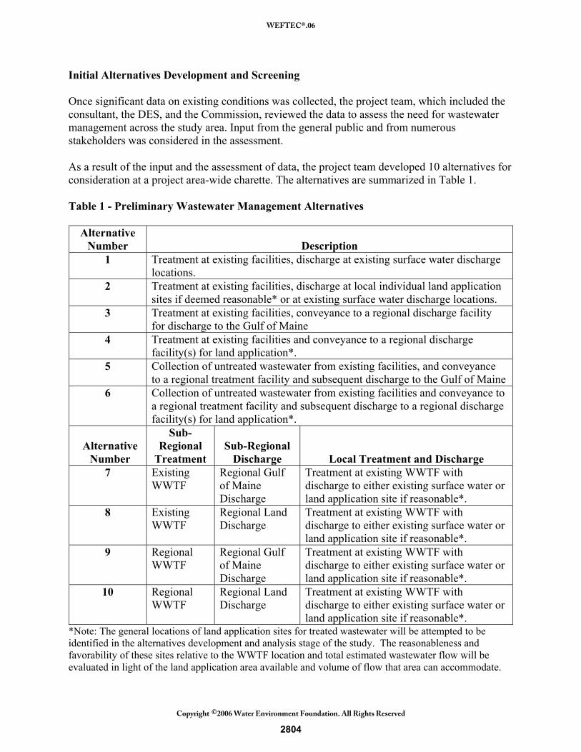
Initial Alternatives Development and Screening Once significant data on existing conditions was collected, the project team, which included the consultant, the DES, and the Commission, reviewed the data to assess the need for wastewater management across the study area. Input from the general public and from numerous stakeholders was considered in the assessment. As a result of the input and the assessment of data, the project team developed 10 alternatives for consideration at a project area-wide charette. The alternatives are summarized in Table 1. Table 1 - Preliminary Wastewater Management Alternatives
Alternative
Number Description 1 Treatment at existing facilities, discharge at existing surface water discharge
locations. 2 Treatment at existing facilities, discharge at local individual land application
sites if deemed reasonable* or at existing surface water discharge locations. 3 Treatment at existing facilities, conveyance to a regional discharge facility
for discharge to the Gulf of Maine 4 Treatment at existing facilities and conveyance to a regional discharge
facility(s) for land application*. 5 Collection of untreated wastewater from existing facilities, and conveyance
to a regional treatment facility and subsequent discharge to the Gulf of Maine 6 Collection of untreated wastewater from existing facilities and conveyance to
a regional treatment facility and subsequent discharge to a regional discharge facility(s) for land application*.
Alternative Number
Sub-Regional
Treatment Sub-Regional
Discharge Local Treatment and Discharge 7 Existing
WWTF Regional Gulf of Maine Discharge
Treatment at existing WWTF with discharge to either existing surface water or land application site if reasonable*.
8 Existing WWTF
Regional Land Discharge
Treatment at existing WWTF with discharge to either existing surface water or land application site if reasonable*.
9 Regional WWTF
Regional Gulf of Maine Discharge
Treatment at existing WWTF with discharge to either existing surface water or land application site if reasonable*.
10 Regional WWTF
Regional Land Discharge
Treatment at existing WWTF with discharge to either existing surface water or land application site if reasonable*.
*Note: The general locations of land application sites for treated wastewater will be attempted to be identified in the alternatives development and analysis stage of the study. The reasonableness and favorability of these sites relative to the WWTF location and total estimated wastewater flow will be evaluated in light of the land application area available and volume of flow that area can accommodate.
2804
WEFTEC®.06
Copyright 2006 Water Environment Foundation. All Rights Reserved©
The alternatives were selected to provide a representative cross section of alternatives. The “No Action” alternative (Alternative 1) called for maintaining the existing wastewater treatment facilities with discharges to existing receiving waters, but upgrading those facilities as would be required to meet future permit limits. The Senate Bill 70 Legislation required that the regional outfall to the Gulf of Maine be evaluated in the feasibility study, thus this alternative (Alternatives 3 and 5) was retained despite the significant opposition to it by the fishermen and by the public concerned about growth management issues. Variations on the regional collection system (Alternatives 7-10) were addressed by establishing several alternatives in which a core group of treatment plants which could benefit from centralized collection and regional discharge and had sufficient flow to make regional collection and discharge a reasonably economical decision were identified. For the most part, these communities were located in the more highly developed portions of the study area, and there was less concern about the potential for explosive secondary growth if a regional wastewater collection and treatment system was implemented. Treatment wetlands were evaluated and determined to be not feasible due to land area requirements and the seasonal problems of long winters in northern climates. Also eliminated during initial screening was an alternative that called for decentralized treatment facilities utilizing cluster or satellite systems. It was thought that these systems may have significant operation and maintenance issues and may not adequately provide a regional wastewater management solution. A few “green” alternatives were maintained; these alternatives called for local treatment followed by local or regional land application (Alternatives 2, 4, 6). Important elements of the initial alternatives development were projecting population growth in the project area, determining future effluent limits that would be applicable to surface water discharges, and determining if land application sites existed for effluent disposal. These issues are briefly discussed below. Growth Projections. Projections of residential growth within the study area were conducted for the 20 and 50 year planning periods (year 2025 and 2055, respectively). The 2025 projections were used to aid in the prediction of wastewater generation and assist in development of alternatives for wastewater management for this feasibility study. The 2055 projections were primarily used for sizing larger, regional infrastructure (i.e., pipelines) required for some of the alternatives. Conducting population projections for this feasibility study entailed a substantial data collection effort. Numerous agencies, organizations, and individuals were contacted to obtain information and expertise regarding population and historic, current, and anticipated growth patterns for municipalities within the study area. Projections to 2025 showed that total study area population is expected to increase approximately 30 percent. Projected population to 2055 was expected to increase an additional 19 percent. Data was reviewed and local planning agencies were contacted to determine anticipated non-residential growth in the project area. Future Effluent Limits. Future effluent limits were determined in consultation with DES, USEPA, and New England Interstate Water Pollution Control Commission. Determination of these limits was important to assess requirements for upgrading existing facilities to treat current and projected future flows. Requirements for effluent limits of an offshore discharge were also established. Table 2 summarizes the proposed limits agreed to in discussion with the regulatory agencies.
2805
WEFTEC®.06
Copyright 2006 Water Environment Foundation. All Rights Reserved©
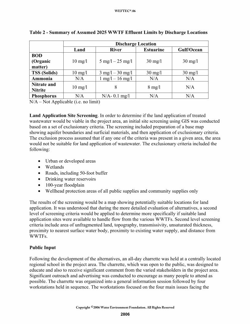
Table 2 - Summary of Assumed 2025 WWTF Effluent Limits by Discharge Locations
Discharge Location Land River Estuarine Gulf/Ocean
BOD (Organic matter)
10 mg/l 5 mg/l – 25 mg/l 30 mg/l 30 mg/l
TSS (Solids) 10 mg/l 3 mg/l – 30 mg/l 30 mg/l 30 mg/l Ammonia N/A 1 mg/l – 16 mg/l N/A N/A Nitrate and Nitrite 10 mg/l 8 8 mg/l N/A
Phosphorus N/A N/A- 0.1 mg/l N/A N/A N/A – Not Applicable (i.e. no limit)
Land Application Site Screening. In order to determine if the land application of treated wastewater would be viable in the project area, an initial site screening using GIS was conducted based on a set of exclusionary criteria. The screening included preparation of a base map showing aquifer boundaries and surficial materials, and then application of exclusionary criteria. The exclusion process assumed that if any one of the criteria was present in a given area, the area would not be suitable for land application of wastewater. The exclusionary criteria included the following:
• Urban or developed areas • Wetlands • Roads, including 50-foot buffer • Drinking water reservoirs • 100-year floodplain • Wellhead protection areas of all public supplies and community supplies only
The results of the screening would be a map showing potentially suitable locations for land application. It was understood that during the more detailed evaluation of alternatives, a second level of screening criteria would be applied to determine more specifically if suitable land application sites were available to handle flow from the various WWTFs. Second level screening criteria include area of unfragmented land, topography, transmissivity, unsaturated thickness, proximity to nearest surface water body, proximity to existing water supply, and distance from WWTFs. Public Input Following the development of the alternatives, an all-day charrette was held at a centrally located regional school in the project area. The charrette, which was open to the public, was designed to educate and also to receive significant comment from the varied stakeholders in the project area. Significant outreach and advertising was conducted to encourage as many people to attend as possible. The charrette was organized into a general information session followed by four workstations held in sequence. The workstations focused on the four main issues facing the
2806
WEFTEC®.06
Copyright 2006 Water Environment Foundation. All Rights Reserved©
project team and decision makers: land use and growth management, technical and engineering, water quality and natural resources, and institutional issues. Attendees at the charrette were divided into four groups. Each group then proceeded to participate in each of the four workstations. Facilitators initiated discussion of key concerns in each topic area, but the primary activity was discussion by the participants. Final Screening and More Detailed Analysis of Selected Alternatives Following completion of the charrette, the project team conducted a second screening to determine the four most feasible alternatives to evaluate in more detail during the evaluation phase. These four alternatives are being assessed using more detailed environmental, planning, technical, cost and non-economic criteria. A critical element of the analysis is the modeling of water quality effects of the proposed alternatives. The water quality modeling is focusing on two concerns: water quality effects in the Gulf of Maine as a result of regional discharge of treated effluent, and water quality effects (primarily changes in salinity) in the estuary as a result of relocating surface water discharges from the rivers and streams to the Gulf of Maine. Reducing freshwater input from the tributaries would result in upstream movement of the salt wedge in some of the receiving waters, potentially altering sensitive estuarine vegetation and associated habitat. The model being used to assess salinity impacts in the estuary is a two-dimensional model that has been developed and calibrated by the University of New Hampshire. The model has been calibrated for salinity from the Gulf of Maine to the first dam on the different receiving waters. Two different models are being used for the analysis of water quality effects in the Gulf of Maine related to a regional discharge. To assess near-field effects, Metcalf & Eddy is developing a three-dimensional (3-D) model using Environmental Fluid Dynamics Code (EFDC). The analysis of far-field effects will be accomplished using a 3-D model developed for the Gulf of Maine Ocean Observing System. The analysis is ongoing at this time. The Draft Alternatives Evaluation Report is scheduled to be completed in late summer 2006. The report will show results of the analyses and compare the alternatives with regard to potential effects. Recommendations will be made with regard to feasibility of alternatives, and also with regard to need for additional studies that may be required depending on the alternatives selected for implementation. SUMMARY OF EXISTING CONDITIONS IN THE PROJECT AREA
The following summarizes the status of the existing WWTFs in the project area, land use and population characteristics, water quality conditions in the receiving waters, and key aspects of natural resource conditions.
2807
WEFTEC®.06
Copyright 2006 Water Environment Foundation. All Rights Reserved©
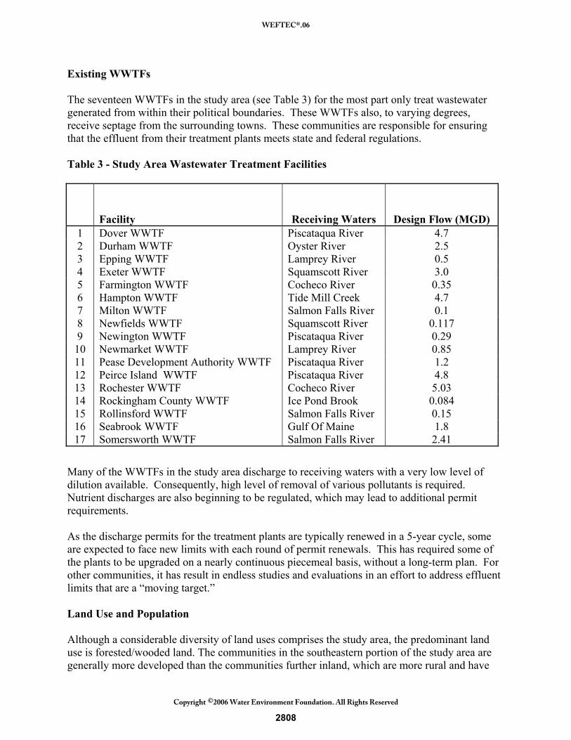
Existing WWTFs The seventeen WWTFs in the study area (see Table 3) for the most part only treat wastewater generated from within their political boundaries. These WWTFs also, to varying degrees, receive septage from the surrounding towns. These communities are responsible for ensuring that the effluent from their treatment plants meets state and federal regulations. Table 3 - Study Area Wastewater Treatment Facilities
Facility Receiving Waters Design Flow (MGD) 1 Dover WWTF Piscataqua River 4.7 2 Durham WWTF Oyster River 2.5 3 Epping WWTF Lamprey River 0.5 4 Exeter WWTF Squamscott River 3.0 5 Farmington WWTF Cocheco River 0.35 6 Hampton WWTF Tide Mill Creek 4.7 7 Milton WWTF Salmon Falls River 0.1 8 Newfields WWTF Squamscott River 0.117 9 Newington WWTF Piscataqua River 0.29 10 Newmarket WWTF Lamprey River 0.85 11 Pease Development Authority WWTF Piscataqua River 1.2 12 Peirce Island WWTF Piscataqua River 4.8 13 Rochester WWTF Cocheco River 5.03 14 Rockingham County WWTF Ice Pond Brook 0.084 15 Rollinsford WWTF Salmon Falls River 0.15 16 Seabrook WWTF Gulf Of Maine 1.8 17 Somersworth WWTF Salmon Falls River 2.41
Many of the WWTFs in the study area discharge to receiving waters with a very low level of dilution available. Consequently, high level of removal of various pollutants is required. Nutrient discharges are also beginning to be regulated, which may lead to additional permit requirements. As the discharge permits for the treatment plants are typically renewed in a 5-year cycle, some are expected to face new limits with each round of permit renewals. This has required some of the plants to be upgraded on a nearly continuous piecemeal basis, without a long-term plan. For other communities, it has result in endless studies and evaluations in an effort to address effluent limits that are a “moving target.” Land Use and Population Although a considerable diversity of land uses comprises the study area, the predominant land use is forested/wooded land. The communities in the southeastern portion of the study area are generally more developed than the communities further inland, which are more rural and have
2808
WEFTEC®.06
Copyright 2006 Water Environment Foundation. All Rights Reserved©
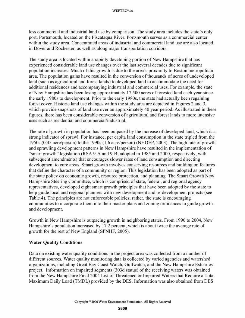
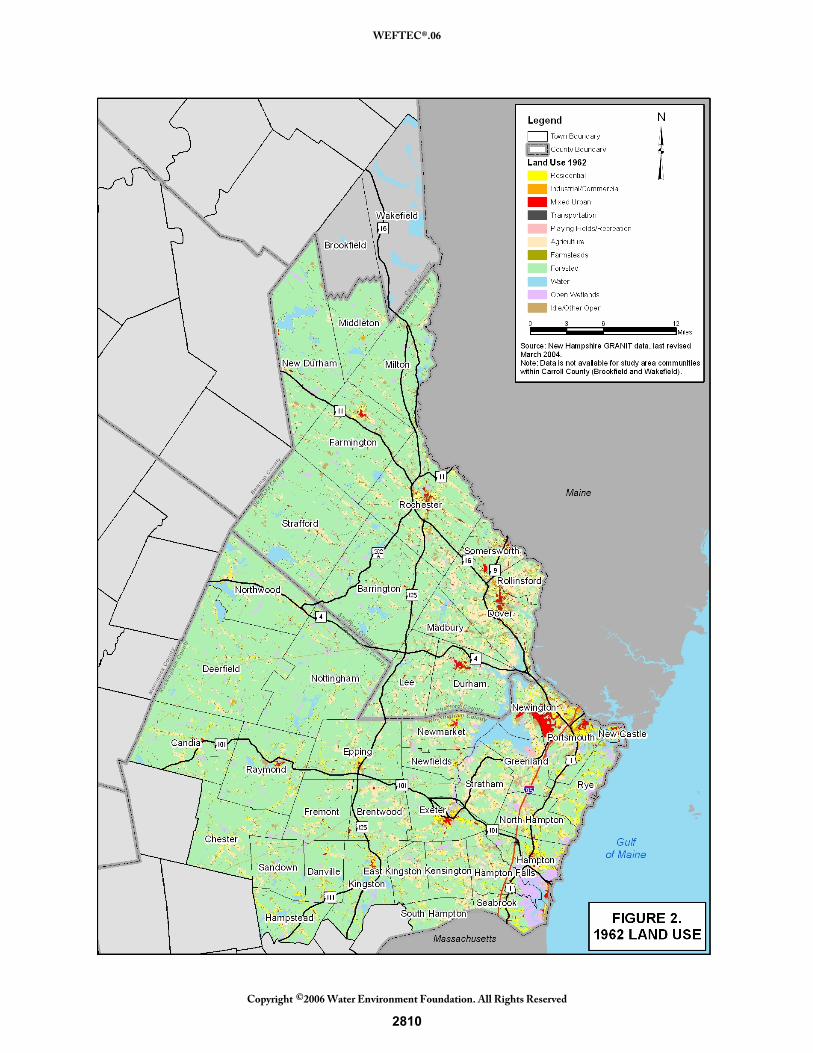
less commercial and industrial land use by comparison. The study area includes the state’s only port, Portsmouth, located on the Piscataqua River. Portsmouth serves as a commercial center within the study area. Concentrated areas of industrial and commercial land use are also located in Dover and Rochester, as well as along major transportation corridors. The study area is located within a rapidly developing portion of New Hampshire that has experienced considerable land use changes over the last several decades due to significant population increases. Much of this growth is due to the area’s proximity to Boston metropolitan area. The population gains have resulted in the conversion of thousands of acres of undeveloped land (such as agricultural and forest lands) to developed land to accommodate the need for additional residences and accompanying industrial and commercial uses. For example, the state of New Hampshire has been losing approximately 17,500 acres of forested land each year since the early 1980s to development. Prior to the early 1980s, the state had actually been regaining forest cover. Historic land use changes within the study area are depicted in Figures 2 and 3, which provide snapshots of land use over an approximately 40 year period. As illustrated in these figures, there has been considerable conversion of agricultural and forest lands to more intensive uses such as residential and commercial/industrial. The rate of growth in population has been outpaced by the increase of developed land, which is a strong indicator of sprawl. For instance, per capita land consumption in the state tripled from the 1950s (0.45 acre/person) to the 1990s (1.6 acre/person) (NHOEP, 2003). The high rate of growth and sprawling development patterns in New Hampshire have resulted in the implementation of “smart growth” legislation (RSA 9-A and 9-B; adopted in 1985 and 2000, respectively, with subsequent amendments) that encourages slower rates of land consumption and directing development to core areas. Smart growth involves conserving resources and building on features that define the character of a community or region. This legislation has been adopted as part of the state policy on economic growth, resource protection, and planning. The Smart Growth New Hampshire Steering Committee, which is comprised of state, federal, and regional agency representatives, developed eight smart growth principles that have been adopted by the state to help guide local and regional planners with new development and re-development projects (see Table 4). The principles are not enforceable policies; rather, the state is encouraging communities to incorporate them into their master plans and zoning ordinances to guide growth and development. Growth in New Hampshire is outpacing growth in neighboring states. From 1990 to 2004, New Hampshire’s population increased by 17.2 percent, which is about twice the average rate of growth for the rest of New England (SPNHF, 2005). Water Quality Conditions Data on existing water quality conditions in the project area was collected from a number of different sources. Water quality monitoring data is collected by varied agencies and watershed organizations, including Great Bay Coast Watch, Gulfwatch, and the New Hampshire Estuaries project. Information on impaired segments (303d status) of the receiving waters was obtained from the New Hampshire Final 2004 List of Threatened or Impaired Waters that Require a Total Maximum Daily Load (TMDL) provided by the DES. Information was also obtained from DES
2809
WEFTEC®.06
Copyright 2006 Water Environment Foundation. All Rights Reserved©
2810
WEFTEC®.06
Copyright 2006 Water Environment Foundation. All Rights Reserved©
2811
WEFTEC®.06
Copyright 2006 Water Environment Foundation. All Rights Reserved©
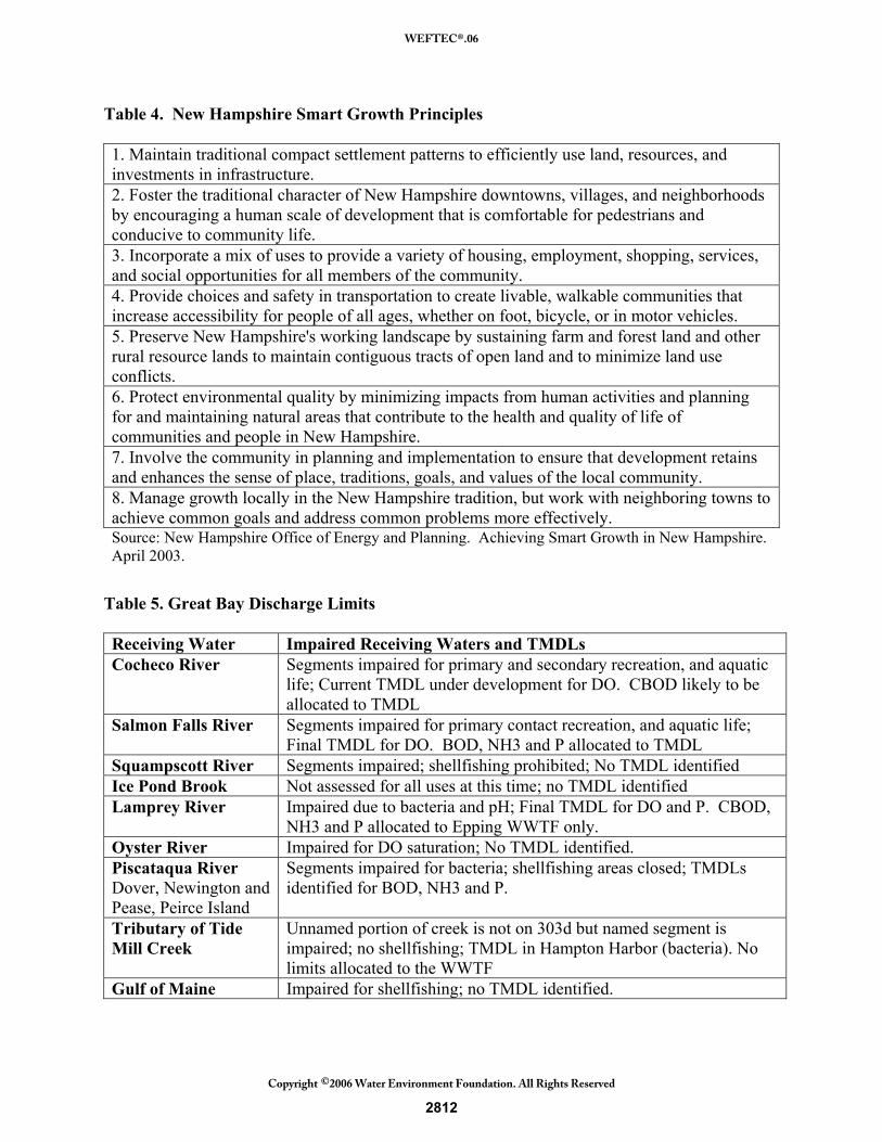
Table 4. New Hampshire Smart Growth Principles 1. Maintain traditional compact settlement patterns to efficiently use land, resources, and investments in infrastructure. 2. Foster the traditional character of New Hampshire downtowns, villages, and neighborhoods by encouraging a human scale of development that is comfortable for pedestrians and conducive to community life. 3. Incorporate a mix of uses to provide a variety of housing, employment, shopping, services, and social opportunities for all members of the community. 4. Provide choices and safety in transportation to create livable, walkable communities that increase accessibility for people of all ages, whether on foot, bicycle, or in motor vehicles. 5. Preserve New Hampshire's working landscape by sustaining farm and forest land and other rural resource lands to maintain contiguous tracts of open land and to minimize land use conflicts. 6. Protect environmental quality by minimizing impacts from human activities and planning for and maintaining natural areas that contribute to the health and quality of life of communities and people in New Hampshire. 7. Involve the community in planning and implementation to ensure that development retains and enhances the sense of place, traditions, goals, and values of the local community. 8. Manage growth locally in the New Hampshire tradition, but work with neighboring towns to achieve common goals and address common problems more effectively. Source: New Hampshire Office of Energy and Planning. Achieving Smart Growth in New Hampshire. April 2003.
Table 5. Great Bay Discharge Limits Receiving Water Impaired Receiving Waters and TMDLs Cocheco River Segments impaired for primary and secondary recreation, and aquatic
life; Current TMDL under development for DO. CBOD likely to be allocated to TMDL
Salmon Falls River Segments impaired for primary contact recreation, and aquatic life; Final TMDL for DO. BOD, NH3 and P allocated to TMDL
Squampscott River Segments impaired; shellfishing prohibited; No TMDL identified Ice Pond Brook Not assessed for all uses at this time; no TMDL identified Lamprey River Impaired due to bacteria and pH; Final TMDL for DO and P. CBOD,
NH3 and P allocated to Epping WWTF only. Oyster River Impaired for DO saturation; No TMDL identified. Piscataqua River Dover, Newington and Pease, Peirce Island
Segments impaired for bacteria; shellfishing areas closed; TMDLs identified for BOD, NH3 and P.
Tributary of Tide Mill Creek
Unnamed portion of creek is not on 303d but named segment is impaired; no shellfishing; TMDL in Hampton Harbor (bacteria). No limits allocated to the WWTF
Gulf of Maine Impaired for shellfishing; no TMDL identified.
2812
WEFTEC®.06
Copyright 2006 Water Environment Foundation. All Rights Reserved©
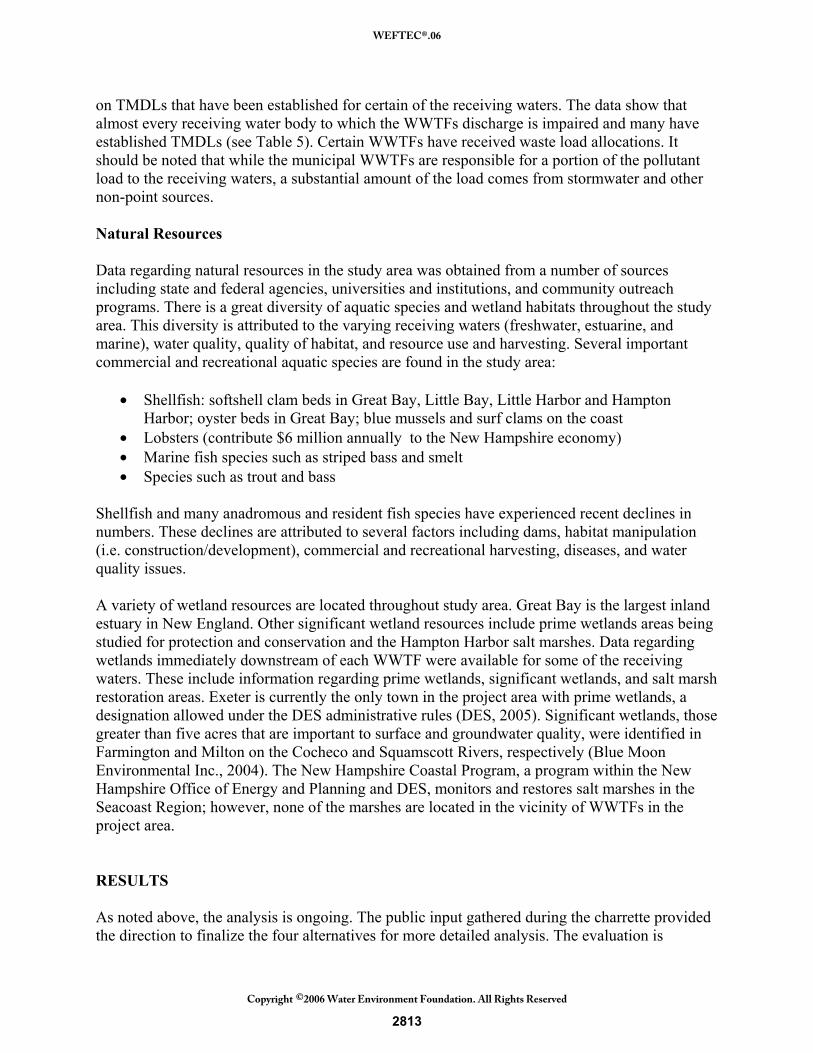
on TMDLs that have been established for certain of the receiving waters. The data show that almost every receiving water body to which the WWTFs discharge is impaired and many have established TMDLs (see Table 5). Certain WWTFs have received waste load allocations. It should be noted that while the municipal WWTFs are responsible for a portion of the pollutant load to the receiving waters, a substantial amount of the load comes from stormwater and other non-point sources. Natural Resources Data regarding natural resources in the study area was obtained from a number of sources including state and federal agencies, universities and institutions, and community outreach programs. There is a great diversity of aquatic species and wetland habitats throughout the study area. This diversity is attributed to the varying receiving waters (freshwater, estuarine, and marine), water quality, quality of habitat, and resource use and harvesting. Several important commercial and recreational aquatic species are found in the study area:
• Shellfish: softshell clam beds in Great Bay, Little Bay, Little Harbor and Hampton Harbor; oyster beds in Great Bay; blue mussels and surf clams on the coast
• Lobsters (contribute $6 million annually to the New Hampshire economy) • Marine fish species such as striped bass and smelt • Species such as trout and bass
Shellfish and many anadromous and resident fish species have experienced recent declines in numbers. These declines are attributed to several factors including dams, habitat manipulation (i.e. construction/development), commercial and recreational harvesting, diseases, and water quality issues. A variety of wetland resources are located throughout study area. Great Bay is the largest inland estuary in New England. Other significant wetland resources include prime wetlands areas being studied for protection and conservation and the Hampton Harbor salt marshes. Data regarding wetlands immediately downstream of each WWTF were available for some of the receiving waters. These include information regarding prime wetlands, significant wetlands, and salt marsh restoration areas. Exeter is currently the only town in the project area with prime wetlands, a designation allowed under the DES administrative rules (DES, 2005). Significant wetlands, those greater than five acres that are important to surface and groundwater quality, were identified in Farmington and Milton on the Cocheco and Squamscott Rivers, respectively (Blue Moon Environmental Inc., 2004). The New Hampshire Coastal Program, a program within the New Hampshire Office of Energy and Planning and DES, monitors and restores salt marshes in the Seacoast Region; however, none of the marshes are located in the vicinity of WWTFs in the project area. RESULTS As noted above, the analysis is ongoing. The public input gathered during the charrette provided the direction to finalize the four alternatives for more detailed analysis. The evaluation is
2813
WEFTEC®.06
Copyright 2006 Water Environment Foundation. All Rights Reserved©
scheduled to be completed by the end of summer 2006, and the findings will be summarized in the Draft Evaluation Report to be submitted to the DES and the Commission in October 2006. These findings will be presented in full during the WEFTEC conference in October 2006. Public Input and Charrette The charrette provided opportunity for input from the general public as well as particular stakeholders. The commercial fishing industry emphasized their concern regarding potential detrimental effects of a new offshore wastewater discharge. Concern about a regional offshore discharge was raised by others as well. Input from the communities reflected concern about the potential for significant secondary growth as a result of extension of collection systems to areas currently restricted to use of on-lot systems. Resource agencies expressed concern about the interbasin transfer of water resources as water that currently was discharged to local tributaries would be redirected to a regional collection and discharge system to the Gulf of Maine. Concern regarding potential effects on groundwater levels and maintenance of aquatic base flow were also expressed. In addition to concerns about economic and environmental issues, there was also concern that while a regional wastewater management strategy may provide benefits to a number of communities, maintaining some local decision making control was important. Following the charette, the alternatives were screened once more to allow selection of four alternatives that would be evaluated in greater detail. Particularly noteworthy is that while the decentralized alternative (calling for local treatment by cluster or satellite systems) had been eliminated during initial screening, there was substantial input at the charette that a decentralized alternative would have several advantages and should be considered in more detail. The benefits were noted as maintaining groundwater levels, reducing the potential for secondary growth, and avoiding the need for regional Gulf of Maine discharge. Thus, the decentralized alternative was selected as one of the four alternatives to undergo more detailed evaluation (see Table 6). Each of the alternatives is now being assessed in the following four areas: water quality and natural resources, technical and cost, land use and growth management, and institutional. DISCUSSION AND CONCLUSION Because the evaluation is still ongoing, it is difficult to reach a conclusion regarding what might be the recommended wastewater management alternative(s) for the Great Bay watershed. However, as the data collection and assessment and the outreach to the public and key stakeholders have proceeded over the last year, certain issues have become evident. These issues are confirming the expected drivers to wastewater management in the estuary. The most significant drivers of wastewater management in the Great Bay Estuary project area are growth control, protection of water quality, maintenance of adequate stream flow and groundwater levels, protection of fisheries (including shellfish), and maintenance of some level of local control. Growth control is paramount in order to minimize the effects of secondary effects (increased community services and loss of open space) and to preserve what residents have come to appreciate as the quality of life in the seacoast area. Protection of water quality resources is important to maintain ecological integrity in the tributaries of Great Bay.
2814
WEFTEC®.06
Copyright 2006 Water Environment Foundation. All Rights Reserved©
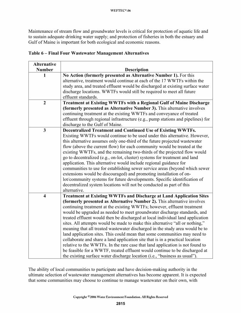
Maintenance of stream flow and groundwater levels is critical for protection of aquatic life and to sustain adequate drinking water supply; and protection of fisheries in both the estuary and Gulf of Maine is important for both ecological and economic reasons. Table 6 – Final Four Wastewater Management Alternatives
Alternative
Number Description 1 No Action (formerly presented as Alternative Number 1). For this
alternative, treatment would continue at each of the 17 WWTFs within the study area, and treated effluent would be discharged at existing surface water discharge locations. WWTFs would still be required to meet all future effluent standards.
2 Treatment at Existing WWTFs with a Regional Gulf of Maine Discharge (formerly presented as Alternative Number 3). This alternative involves continuing treatment at the existing WWTFs and conveyance of treated effluent through regional infrastructure (e.g., pump stations and pipelines) for discharge to the Gulf of Maine.
3 Decentralized Treatment and Continued Use of Existing WWTFs. Existing WWTFs would continue to be used under this alternative. However, this alternative assumes only one-third of the future projected wastewater flow (above the current flow) for each community would be treated at the existing WWTFs, and the remaining two-thirds of the projected flow would go to decentralized (e.g., on-lot, cluster) systems for treatment and land application. This alternative would include regional guidance for communities to use for establishing sewer service areas (beyond which sewer extensions would be discouraged) and promoting installation of on-lot/community systems for future developments. Specific identification of decentralized system locations will not be conducted as part of this alternative.
4 Treatment at Existing WWTFs and Discharge at Land Application Sites (formerly presented as Alternative Number 2). This alternative involves continuing treatment at the existing WWTFs; however, effluent treatment would be upgraded as needed to meet groundwater discharge standards, and treated effluent would then be discharged at local individual land application sites. All attempts would be made to make this alternative “all or nothing,” meaning that all treated wastewater discharged in the study area would be to land application sites. This could mean that some communities may need to collaborate and share a land application site that is in a practical location relative to the WWTFs. In the rare case that land application is not found to be feasible for a WWTF, treated effluent would continue to be discharged at the existing surface water discharge location (i.e., “business as usual”).
The ability of local communities to participate and have decision-making authority in the ultimate selection of wastewater management alternatives has become apparent. It is expected that some communities may choose to continue to manage wastewater on their own, with
2815
WEFTEC®.06
Copyright 2006 Water Environment Foundation. All Rights Reserved©
minimal coordination with other communities in the region. However, it is expected that several communities or even several groups of communities may recognize the environmental and economic benefit of a regional approach, and these communities may join together to implement some form of regional treatment and disposal. It is clear that the findings of this study will provide the basis for decision making at the state and local level regarding wastewater management strategies. All of the parties involved recognize that the study provides a valuable foundation for planning for future growth and development. ACKNOWLEDGEMENTS We would like to thank the New Hampshire Seacoast Region Wastewater Management Feasibility Study project team (the New Hampshire Department of Environmental Services and the Great Bay Estuary Commission) and subconsultants (ENSR, Appledore Engineering, Steve Jones, TF Moran, Wright Pierce, and Gallagher, Callahan & Gartrel) for their important contributions and helpful comments. REFERENCES Blue Moon Environmental, Inc. 2004. Use of GIS Data to Assist in the Selection and
Identification of Significant Wetlands in the Moose Mountains Regional Greenways. Moose Mountains Regional Greenways and New Hampshire Estuaries Project. 169+ pp.
DES, 2005. New Hampshire Department of Environmental Services. Guidebook for Wetland
Permits. Web page http://www.des.state.nh.us/wetlands/Guidebook/primewet.htm Accessed September 2005.
M&E, 2005. Metcalf & Eddy, Inc. New Hampshire Seacoast Region Wastewater Management
Feasibility Study, Draft Preliminary Findings Report. October 2005. NHEP, 2003. New Hampshire Estuaries Project. State of the Estuaries, 2003. NHOEP, 2003. New Hampshire Office of Energy and Planning. Achieving Smart Growth in
New Hampshire. April 2003. SPNHF, 2005. Society for the Protection of New Hampshire Forests. New Hampshire’s
Changing Landscapes 2005. Population Growth and Land Use Changes: What They Mean for the Granite State.
2816
WEFTEC®.06
Copyright 2006 Water Environment Foundation. All Rights Reserved©