Embed Size (px)
Citation preview
Criteria for assessing
ecological coherence of
MPA networks: A review
Marija Sciberras, David Rodríguez-
Rodríguez, Benjamin Ponge, Emma
Jackson
Coherence

Criteria for assessing ecological coherence of MPA networks
A review
Coherence
Prepared on behalf of
by
Author(s): Marija Sciberras, David Rodríguez-Rodríguez,
Benjamin Ponge, Emma Jackson
Contact : David Rodríguez-Rodríguez
In the frame of
Work Package 1
Work quotation: Sciberras, M., Rodriguez-Rodriguez, D., Ponge, B., Jackson, E. 2013. Criteria for assessing ecological coherence of MPA networks: A review. Report prepared by the Marine Institute
and the Agence des Marines Protegees for the Protected Area Network Across the Channel Ecosystem (PANACHE) project. INTERREG programme France (Channel) – England (2007 – 2013)
funded project, 48 pp. Cover photo: Julie Hatcher, Dorset Wildlife Trust
This publication is supported by the European Union (ERDF European Regional Development Fund), within the INTERREG IVA France (Channel) – England European cross-border co-operation programme under the Objective 4.2. “Ensure a sustainable environmental development of the common space” - Specific Objective 10 “Ensure a balanced management of the environment and raise awareness about environmental issues”. Its content is under the full responsibility of the author(s) and does not necessarily reflect the opinion of the European Union. Any reproduction of this publication done without author’s consent, either in full or in part, is unlawful. The reproduction for a non commercial aim, particularly educative, is allowed without written authorization, only if sources are quoted. The reproduction for a commercial aim, particularly for sale, is forbidden without preliminary written authorization of the author.
Criteria for assessing ecological coherence of MPA
networks: A review
Critères d’évaluation de la cohérence écologique des réseaux d’AMP : une synthèse
ABSTRACT
Identifying and protecting marine features through the establishment of marine protected areas (MPAs) is an important step towards conserving biodiversity, yet it is insufficient from an ecological perspective. An ecologically coherent network of well-managed MPAs is now a requirement of a number of international, regional and national directives to effectively protect biodiversity. This means having a network of well-conserved MPAs representing the full variety of a region’s ecosystems, with sites close enough together to allow movement of individuals among them. Historically, MPAs have been established on an ad-hoc basis over varying timescales and with different conservation objectives. Thus, a range of MPA characteristics and a number of ecological processes need to be evaluated to determine if a collection of MPAs within a given region forms an ecologically coherent network. Several criteria have been proposed to further improve the assessment and design of ecologically coherent MPA networks and ensure consistency across regions. Six of these criteria are reviewed here: representativity, replication, adequacy, connectivity, level of protection and resilience. Four case studies are then discussed, providing examples of how these criteria have been used in the establishment of ecologically coherent MPA networks.
RÉSUMÉ
Identifier et protéger les caractéristiques marines d’intérêt à travers la création d’aires marines protégées (AMPs) est une étape importante dans la conservation de la biodiversité, mais pourtant insuffisant du point de vue écologique. Un réseau écologiquement cohérent d’AMPs bien gérées est désormais une nécessité de plusieurs directives internationales, régionales ou nationales, afin de gérer effectivement la biodiversité. Cela signifie avoir un réseau d’AMPs bien conservées représentant tout l’éventail des écosystèmes d’une région, avec des sites suffisamment proches les uns des autres afin de permettre le mouvement des individus entre eux. Historiquement, les AMPs ont été établies de façon ad-hoc à différents intervalles et pour des objectifs différents. Un ensemble de caractéristiques d’intérêt et de processus écologiques ont donc besoin d’être évalués afin de déterminer si un groupe d’AMPs dans une région donnée forme un réseau écologiquement cohérent. Plusieurs critères ont été proposés afin d’améliorer l’évaluation et le design d’un réseau écologiquement cohérent d’AMPs, et ce dans les différents régions. Six critères ont été étudiés dans ce rapport : représentativité, réplication, adéquation, connectivité et niveaux de protection et de résilience. Quatre études de cas ont été ensuite discutées, permettant de montrer comment ces critères ont été utilisés dans la création d’un réseau écologiquement cohérent d’AMPs.
KEYWORDS: protection, network, coherence, connectivity, representativity, replication, adequacy
MOTS-CLÉS : protection, réseau, cohérence, connectivité, représentativité, réplication, adéquation

PANACHE – Protected Area Network Across the Channel Ecosystem
Acknowledgements
We would like to thank a number of people for their contribution to this review through very useful
discussions held during an ‘expert workshop’ on the ecological criteria of ecological coherence of MPA
networks organized by PANACHE at the Marine Institute, University of Plymouth on the 20th of March
2013: Vincent Toison (Agence des aires marines protégées), Paul St. Pierre (Royal Society for the
Protection of Birds), Helen Booker (Royal Society for the Protection of Birds), Niki Clear (Cornwall
Wildlife Trust), Sabine Christiansen (World Wildlife Fund-UK), Peter Chaniotis (Joint Nature
Conservation Committee), Ilaria Marengo (Joint Nature Conservation Committee), Louise
Lieberknecht (University College London), Tom Hooper (SeaLife Consultancy), Kerstin Kroeger
(OSPAR), Emily Cocoran (OSPAR), Olivia Langmead (Marine Institute/Marine Biological Association),
Simon Pittman (Marine Institute/National Oceanic and Atmospheric Administration), Sangeeta McNair
(Natural England), Jen Ashworth (Natural England).
PANACHE – Protected Area Network Across the Channel Ecosystem
Contents
I. Introduction ....................................................................................................................................... 1
1.1 Defining Ecological Coherence (EC) ................................................................................... 1
1.2. Policy background ............................................................................................................... 2
1.3. MPA categories within the framework of the PANACHE project ......................................... 7
II. Criteria for assessing ecological coherence of MPA networks ...................................................... 10
2.1. Representativity ................................................................................................................. 12
2.2. Replication ......................................................................................................................... 15
2.3. Adequacy ........................................................................................................................... 17
2.4. Connectivity ....................................................................................................................... 21
2.5. Level of protection ............................................................................................................. 22
2.6. Resilience .......................................................................................................................... 24
III. Essential sub-criteria ..................................................................................................................... 26
3.1. Areas of ecological importance ......................................................................................... 26
3.2. Vulnerability, rarity & degree of threat of protected features ............................................. 26
3.3. Risks - Past, present and foreseeable future threats ........................................................ 27
IV. Factors influencing Ecological Coherence ................................................................................. 28
4.1. Governance ....................................................................................................................... 28
4.2. Legislation .......................................................................................................................... 28
4.3. Planning ............................................................................................................................. 28
4.4. Society ............................................................................................................................... 28
4.5. Economy ............................................................................................................................ 29
4.6. Culture ............................................................................................................................... 29
V. Case studies of ecologically coherent MPA networks ................................................................... 30
5.1. Case-study 1: Kimbe Bay MPA network, West New Britain, Papua New Guinea ............ 30
5.2. Case-study 2: Channel Islands, California MPA network .................................................. 32
5.3. Case study 3: Commonwealth marine reserves network, Australia .................................. 34
5.4. Case study 4: Towards establishing an ecologically coherent network in the UK: Marine
Conservation Zones ....................................................................................................................... 37
References ......................................................................................................................................... 40
1
I. Introduction
Whilst identifying and protecting marine features by establishing marine protected areas (MPAs) is an
important step towards safeguarding biodiversity, this is insufficient from an ecological viewpoint
(Jones et al., 2007). Throughout their life cycle marine species are likely to disperse in different parts
of the oceans through their larvae, juvenile and/or adult stages (Shanks et al., 2003). Therefore, what
is needed to protect biodiversity more effectively is an ecologically coherent network of well-managed
MPAs (OSPAR, 2006) coupled with the long term sustainable anthropogenic use of the ocean
(Halpern et al. 2010).This means having a network of well-conserved sites representing the full variety
of a region’s ecosystems, large enough to protect rare, threatened and valued species, habitats and
ecological processes throughout our seas, with sites close enough for species to move between them
and enough sites to conserve a range of features that are vital for the health of marine ecosystems.
1.1 Defining Ecological Coherence (EC)
There is no universally accepted definition of “ecological coherence” (EC) within the scientific
community. The term is not often used in the scientific literature (mainly owing to the legal origin of the
concept), and when it is, it may be used in a different context to MPA networks, for example it may
imply genetic relatedness (Ardron, 2008). Nevertheless, the term appears more often in the grey
literature, usually in the context of Natura 2000 network, where it generally implies some sort of
connectivity among structures or ecological processes (Ardron, 2008). Most scientific and technical
documents on the topic refer to “ecological representativeness” of MPA networks instead (Wells et al.,
2007; UNEP-WCMC, 2008; Australian Government, 2013). For example, the global target of the
Convention on Biological Diversity is to explicitly establish a global network of representative MPAs.
Thus, although having different implications, the terms “representativeness” and “coherence” are often
used synonymously when referring to protected area networks or systems (CBD, 2010).
According to OSPAR, an “ecologically coherent network” of MPAs is defined as follows (OSPAR,
2007):
“An ecologically coherent network of MPAs:
(i) interacts and supports the wider environment;
(ii) maintains the processes, functions, and structures of the intended protected features
across their natural range;
(iii) functions synergistically as a whole, such that the individual protected sites benefit from
each other to achieve the two objectives above; and
(iv) (additionally) may be designed to be resilient to changing conditions”.
The World Commission on Protected Areas defines a MPA network as “a collection of individual MPAs
or reserves operating co-operatively and synergistically, at various spatial scales and with a range of
2
protection levels that are designed to meet objectives that a single reserve cannot achieve” (IUCN-
WCPA, 2008).
Other definitions exist in the literature. According to Bennet and Wit (2001), an ecological network is
regarded as "a coherent system of natural and/or semi-natural landscape elements that is configured
and managed with the objective of maintaining or restoring ecological functions as a means of
conserving biodiversity while also providing appropriate opportunities for the sustainable use of natural
resources". In the context of Natura 2000 network (EU, 1992), Catchpole (2012) states that “…at the
scale of the whole network, coherence is achieved when: the full range of variation in valued features
is represented; replication of specific features occurs at different sites over a wide geographic area;
dispersal, migration and genetic exchange of individuals is possible between relevant sites; all critical
areas for rare, highly threatened and endemic species are included; and the network is resilient to
disturbance or damage caused by natural and anthropogenic factors”.
Some countries have their own definitions. For example, Canada defines a network, in its Federal
MPA strategy (Government of Canada, 2005), as: “A set of complementary and ecologically linked
MPAs, consisting of a broad spectrum of MPAs, established and managed within a sustainable ocean
management planning framework and linked to trans boundary, global and terrestrial protected area
networks”.
1.2. Policy background
1.2.1. International and regional requirements for Ecologically Coherent Network
(ECN) of MPAs
The Birds Directive (Council Directive 79/409/EEC; EU, 1979) was perhaps the first environmental
policy document to refer to “coherence”. Article 4.3 of this Directive states: “Member States shall send
the Commission all relevant information so that it may take appropriate initiatives with a view to the
coordination necessary to ensure that the areas provided for in paragraphs 1 and 2 above form a
coherent whole which meets the protection requirements of these species in the geographical sea and
land area where this Directive applies”.
One of the first mentions of the term “ecological coherence” was made in the preamble to the Habitats
Directive (Council Directive 92/43/EEC; EU, 1992). Article 3.1 of this Directive states: “A coherent
European ecological network of special areas of conservation shall be set up under the title Natura
2000. This network, composed of sites hosting the natural habitat types listed in Annex I and habitats
of the species listed in Annex II, shall enable the natural habitat types and the species' habitats
concerned to be maintained or, where appropriate, restored at a favourable conservation status in
their natural range”. In addition, Article 10 of the same Directive states that “Where they consider it
necessary, Member States shall endeavour to improve the ecological coherence of Natura 2000 by
3
maintaining, and where appropriate developing, features of the landscape which are of major
importance for wild fauna and flora”.
In 2003, the Helsinki and OSPAR Commissions committed to establish an ecologically coherent
network of well-managed MPAs by 2010 (HELCOM, 2003a). This network consists of Baltic Sea
Protected Areas (BSPAs) in the Baltic Sea, OSPAR Marine Protected Areas in the North East Atlantic
and the Natura 2000 network (coastal and marine Special Areas of Conservation and Special
Protection Areas). According to the Ministerial Declaration, the assessment of the ecological
coherence of the network should be done in 2010 and periodically thereafter (HELCOM, 2003a). As a
result of this meeting, a joint HELCOM/OSPAR Working Programme on MPAs was adopted in 2003
(HELCOM, 2003b) to develop both theoretical and more practical criteria to evaluate the networks. In
2006, OSPAR disclosed a guidance document on “developing an ecologically coherent network of
marine protected areas” aimed at setting up principles to help interpreting the concept of an
“ecologically coherent network” in the context of a network of OSPAR MPAs (OSPAR, 2006). This
guidance was further complemented with the disclosure of a “Background Document to Support the
Assessment of Whether the OSPAR Network of Marine Protected Areas is Ecologically Coherent
(OSPAR, 2007). Despite the collective efforts by OSPAR Contracting Parties in selecting and
establishing MPAs in the North-East Atlantic in the period 2005-2010, the network of MPAs in 2010
was not considered to be ecologically coherent throughout the entire OSPAR maritime area.
Therefore, a revised target to establish an ecologically coherent network of MPAs in the north-east
Atlantic by 2012 and to ensure it is well-managed by 2016 was recommended (OSPAR, 2010).
The target of establishing an ecologically coherent network of protected areas was also incorporated
into the Programme of Work on Protected Areas (PoWPA; CBD, 2004). The overall objective of the
PoWPA was the establishment and maintenance of a global network of comprehensive, effectively
managed and ecologically representative national and regional systems of protected areas by 2010 for
terrestrial and by 2012 for marine areas (CBD, 2004). This target was later on reaffirmed in the 2010
Xth CBD COP, where “the need to enhance efforts towards achieving the 2012 target of establishment
of a representative network of marine protected areas” was stated (CBD, 2010).
Article 13.4 of the Marine Strategy Framework Directive (MSFD; EU, 2008) also refers to ecological
coherence of MPAs: “…measures established pursuant to this Article shall include spatial protection
measures, contributing to coherent and representative networks of MPAs, adequately covering the
diversity of the constituent ecosystems, such as special areas of conservation pursuant to the Habitats
Directive, special protection areas pursuant to the Birds Directive, and marine protected areas as
agreed by the Community or Member States concerned in the framework of international or regional
agreements to which they are parties”.
4
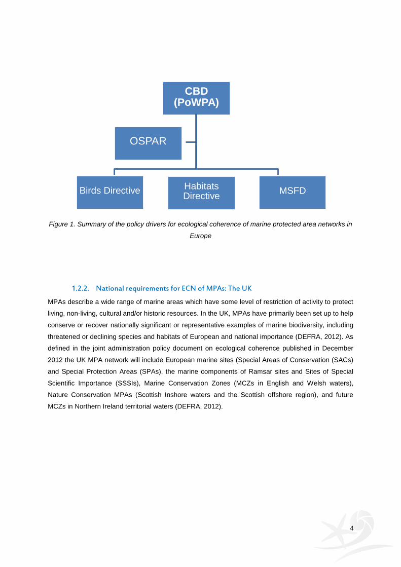
Figure 1. Summary of the policy drivers for ecological coherence of marine protected area networks in
Europe
1.2.2. National requirements for ECN of MPAs: The UK
MPAs describe a wide range of marine areas which have some level of restriction of activity to protect
living, non-living, cultural and/or historic resources. In the UK, MPAs have primarily been set up to help
conserve or recover nationally significant or representative examples of marine biodiversity, including
threatened or declining species and habitats of European and national importance (DEFRA, 2012). As
defined in the joint administration policy document on ecological coherence published in December
2012 the UK MPA network will include European marine sites (Special Areas of Conservation (SACs)
and Special Protection Areas (SPAs), the marine components of Ramsar sites and Sites of Special
Scientific Importance (SSSIs), Marine Conservation Zones (MCZs in English and Welsh waters),
Nature Conservation MPAs (Scottish Inshore waters and the Scottish offshore region), and future
MCZs in Northern Ireland territorial waters (DEFRA, 2012).
CBD (PoWPA)
OSPAR
Birds Directive Habitats
Directive
MSFD

5
The UK has committed to a number of international agreements on MPAs including an ecologically
coherent network of MPAs in the North East Atlantic. Together with neighbouring countries, the UK
network will act as a contribution to the network based on OSPAR Convention, World Summit on
Sustainable Development and Convention on Biological Diversity (DEFRA, 2012). There are also links
to European Directives such as the Marine Strategy Framework Directive and EC Birds and Habitats
Directives which make reference to establishing coherent networks. National requirements under
Clause 123 of the Marine and Coastal Access Act (“Creation of network of conservation sites”)
requires that MCZs and European marine sites established in the UK marine area form a network that
satisfies the following conditions:
(a) that the network contributes to the conservation or improvement of the marine environment in the
UK marine area;
(b) that the features1
which are protected by the sites comprised in the network represent the range of
features present in the UK marine area;
(c) that the designation of sites comprised in the network reflects the fact that the conservation of a feature may require the designation of more than one site.”
1 Features are described under Clause 117 of the Marine and Coastal Access Act as referring to marine flora and
fauna; marine habitats or type of marine habitat; features of geological or geomorphological interest
6
1.2.3. National requirements for ECN of MPAs: France
a) Environmental code Article L334-1 / Code de l’environnement Article L334-1
I. Is created a national public establishment of
an administrative nature named: “Marine
Protected Areas Agency” (Agence des aires
marines protégées).
II. The Agency coordinates the network of
French marine protected areas and contributes
to the French participation for the creation and
management of marines protected areas
decided at the international level.
I.-Il est créé un établissement public national à
caractère administratif dénommé " Agence des
aires marines protégées ".
II.-L'agence anime le réseau des aires marines
protégées françaises et contribue à la
participation de la France à la constitution et à
la gestion des aires marines protégées
décidées au niveau international.
To this end, the Agency can be appointed for
the direct management of marines protected
areas.
The Agency provides a technical,
administrative and scientific assistance to other
managers of marine protected areas and
initiates projects of marine protected areas in
order to form a coherent network. The Agency
thus contributes to the implementation of
international commitments of France in the
interest of marine and coastal biological
diversity.
A cette fin, elle peut se voir confier la gestion
directe d'aires marines protégées. Elle apporte
son appui technique, administratif et
scientifique aux autres gestionnaires d'aires
marines protégées et suscite des projets
d'aires marines protégées afin de constituer un
réseau cohérent. Elle contribue ainsi à la mise
en œuvre des engagements internationaux de
la France en faveur de la diversité biologique
marine et côtière.
b) French National Strategy on Biodiversity 2010-2020 (SNB 2010-2020) /
Stratégie française pour la biodiversité 2010-2020 (SNB 2010-2020)
The French National Strategy on Biodiversity
for 2010-2020 entails 20 objectives turned on 6
strategic orientations, among which some
directly involve the network of marine protected
areas:
5 – build up an ecological infrastructure
including a coherent network of protected
areas;
La SNB 2011-2020 comprend 20 objectifs
articulés en 6 orientations stratégiques, parmi
lesquels certains concernent directement le
réseau des aires marines protégées :
5 – construire une infrastructure écologique
incluant un réseau cohérent d’espaces
protégés ;
7
c) French National Strategy on Marine Protected Areas 2012 / Stratégie nationale
française pour les aires marines protégées 2012
1.5 Principles for a complete and coherent
network
1.5.2 A network contributing to the good status
of marine ecosystems: representativeness,
connectivity, replication
1.5 Principes pour un réseau complet et
cohérent
1.5.2 Un réseau contribuant au bon état des
écosystèmes marins : représentativité,
connectivité, réplication
1.3. MPA categories within the framework of the PANACHE project
MPAs may be designated under international conventions, european or national legislation (see
below). Additionally, MPAs may also be established under voluntary codes of conduct and through
fisheries bye-laws targeting the management of particular stocks. For example, in the Western
Channel, Wembury and the surrounding coastline on the UK coast is a Voluntary Marine Conservation
Area (VMCA) and the area in Start Bay is a trawling exclusion area established under the Devon and
Severn Inshore Fisheries Conservation fisheries bye-laws.
For the purpose of this review, we will focus on statutory MPA categories occurring within the Channel
area that are included towards achieving an ecologically coherent network of MPAs within each
respective country (i.e. France and UK).
1.3.1. UK
1. Special Areas of Conservation (SACs). This category of protected areas falls within the
broader category “European Marine Sites”, and was originally set up in the article 3 of the
Habitats Directive. According to the directive, SACs “hosting the natural habitat types listed in
Annex I and habitats of the species listed in Annex II, shall enable the natural habitat types
and the species' habitats concerned to be maintained or, where appropriate, restored at a
favourable conservation status in their natural range” (EU, 1992).
2. Special Protection Areas (SPAs). This category is also included within the broader category
“European Marine Sites”, and was originally established in the Birds Directive (EU, 1979).
SPAs should be made up of the most suitable territories in number and size for the
conservation of the bird species mentioned in the Annex I in the geographical sea and land
area covered by the Directive in order to ensure their survival and reproduction in their area of
distribution.
8
3. Sites of Special Scientific Interest (SSSIs). SSSIs are designated for the protection of the most
significant sites for the conservation of wildlife (species & habitats) and/or geology (NE, 2013).
4. Ramsar sites with marine components. These sites are designated under the Ramsar
Convention (Ramsar Convention, 1971) to protect wetlands of international importance in
terms of ecology, botany, zoology, limnology or hydrology. In the first instance wetlands of
international importance to waterfowl at any season should be included. “Wetlands” are
defined as: “areas of marsh, fen, peatland or water, whether natural or artificial, permanent or
temporary, with water that is static or flowing, fresh, brackish or salt, including areas of marine
water the depth of which at low tide does not exceed six metres”.
To date, all OSPAR MPAs in the UK are also “European Marine Sites” (i.e. N2000 sites). Marine
Conservation zones (MCZs) may form an additional MPA category within the Channel area. Under the
Marine and Coastal Access Act (2009), MCZs can be established for conserving marine fauna, flora,
habitats, geological or geomorphological features. Although 13 potential MCZ areas have been
proposed for the Channel area, the consultation process is still on-going and to date, no MCZs have
been designated in the UK.
1.3.2. France
In France, there were originally 6 categories of MPAs in use, but these have been currently extended
to 15 categories in 2011, 8 of which are in use in the Channel:
1. Natura 2000 sites
Site d’importance communautaire (SAC)
Zone de protection spéciale (SPA)
2. Reserve naturelle nationale ou régionale (National or Regional Nature Reserves). These sites
are mainly terrestrial and are created to protect fauna, flora, soil, waters, mineral deposit and
fossils or whichever environment of particular significance or that needs to be prevented from
artificial activity susceptible to degrade them. They are created by the state (national) or on
local impulse (regional), and are considered to be MPAs if they have a maritime part.
3. Parcs naturels marins (Marine natural parks). Recent creation (2006) the marine natural parks
are MPAs designed for an integrated management of a large scale area. They contribute to
knowledge, as to protection and sustainable development of the marine environment. They
are created following a public inquiry and always managed directly by a team attached to the
Agence des aires marines protégées.
4. Arrêtés de protection de biotope (Prefectoral Orders for the Protection of Biotopes). These
protected areas are established by the prefect to protect the biotopes necessary for feeding,
9
breeding, resting and surviving for protected vegetal or animal species to prevent their
extinction. They are considered as MPAs if they have a maritime part.
5. Parties maritimes du domaine relevant du Conservatoire de l'espace littoral et des rivages
lacustres (Public Coastal Domain Sites entrusted to Coastline Conservation). Public land
policy, carried out in partnership with local authorities to conserve the coastal area and the
maintenance of natural sites and the ecological balance by acquiring land in order to ensure
long term protection of fragile and threatened sites.
6. Ramsar Sites with marine components. These sites are designed under the Ramsar
Convention (Ramsar Convention, 1971) as in UK, to protect the same wetlands of
international importance in terms of ecology, botany, zoology, limnology or hydrology.
7. OSPAR Sites. To date, some of the Natura 2000 sites, Marine Natural Parks or Nature
Reserves are registered as OSPAR sites, meeting the requirements asked by the
commission.
8. Biosphere Reserves
10
II. Criteria for assessing ecological coherence of MPA
networks
Several criteria have been proposed to help build and assess an ecologically coherent network of
MPAs. In 2006, OSPAR Contracting Parties developed five key criteria of Ecological Coherence:
Features, Representativity, Connectivity, Resilience and Management that sat under 13 agreed MPA
network design principles (OSPAR, 2006). Replication was also considered within OSPAR (2006),
expressed as a contributory factor towards network Resilience. However, in subsequent OSPAR
papers, Replication is noted as an element of ecological coherence in its own right (OSPAR, 2008a).
Adequacy/Viability is widely accepted as an additional element of ecological coherence, as identified
by HELCOM in collaboration with BALANCE (Piekäinen and Korpinen, 2008). The seven network
design principles used to guide the development of an ecologically coherent network of MPAs in the
UK (refer to DEFRA, 2010; NE and JNCC, 2010) include Representativity, Connectivity, Replication,
Viability, Adequacy, Protection and Best available evidence. Under these principles, Viability
necessitates that MPAs within the network are large enough to enable most ecological processes to
operate within it and is sufficient to encompass the home ranges of species which are target for
protection (NE and JNCC, 2010). Adequacy, on the other hand, necessitates that areas should be
large enough to ensure the ecological viability and integrity of populations, species and communities,
by retaining that the proportion of each feature included within the MPA network is sufficient to enable
its long term protection and/or recovery (NE and JNCC, 2010). Protection addresses the range of
protection levels that may occur within the MPA network. Together, these principles are expected to
deliver an MPA network that contributes to the resilience of the marine ecosystem (DEFRA, 2010).
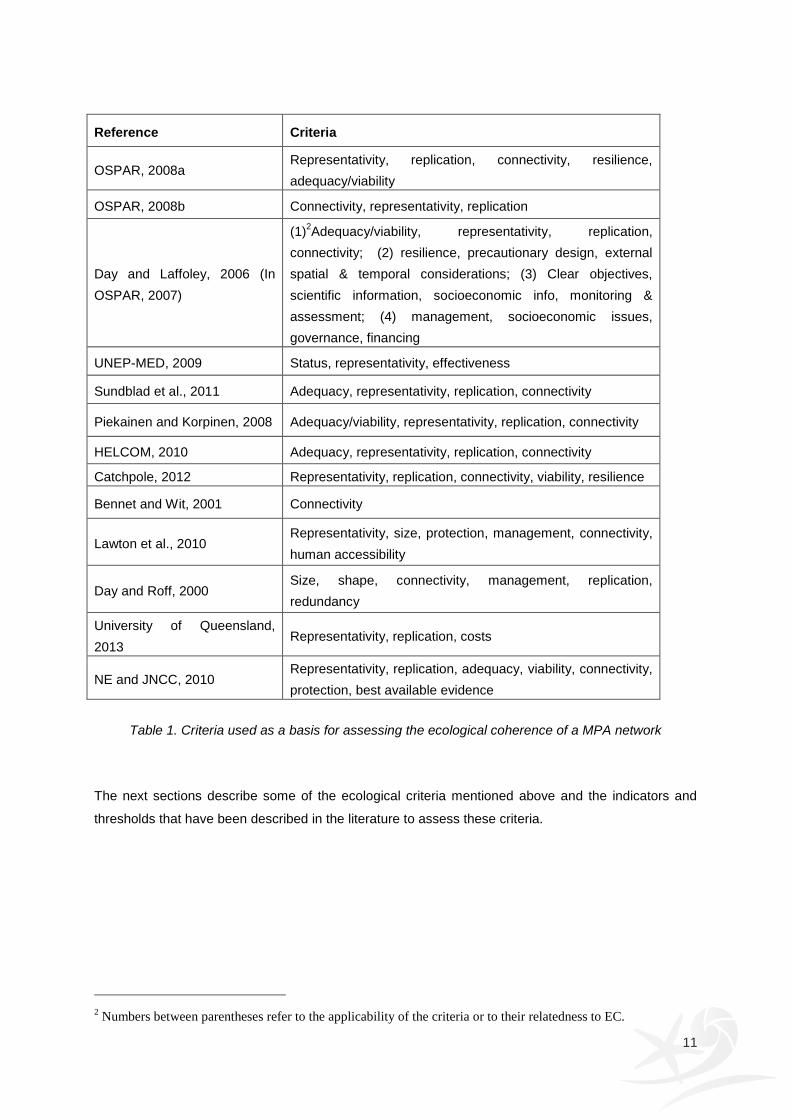
Table 1 identifies the criteria that different authors or organizations proposed as a basis for assessing
the ecological coherence of a MPA network.
11
Reference Criteria
OSPAR, 2008a Representativity, replication, connectivity, resilience,
adequacy/viability
OSPAR, 2008b Connectivity, representativity, replication
Day and Laffoley, 2006 (In
OSPAR, 2007)
(1)2Adequacy/viability, representativity, replication,
connectivity; (2) resilience, precautionary design, external
spatial & temporal considerations; (3) Clear objectives,
scientific information, socioeconomic info, monitoring &
assessment; (4) management, socioeconomic issues,
governance, financing
UNEP-MED, 2009 Status, representativity, effectiveness
Sundblad et al., 2011 Adequacy, representativity, replication, connectivity
Piekainen and Korpinen, 2008 Adequacy/viability, representativity, replication, connectivity
HELCOM, 2010 Adequacy, representativity, replication, connectivity
Catchpole, 2012 Representativity, replication, connectivity, viability, resilience
Bennet and Wit, 2001 Connectivity
Lawton et al., 2010 Representativity, size, protection, management, connectivity,
human accessibility
Day and Roff, 2000 Size, shape, connectivity, management, replication,
redundancy
University of Queensland,
2013 Representativity, replication, costs
NE and JNCC, 2010 Representativity, replication, adequacy, viability, connectivity,
protection, best available evidence
Table 1. Criteria used as a basis for assessing the ecological coherence of a MPA network
The next sections describe some of the ecological criteria mentioned above and the indicators and
thresholds that have been described in the literature to assess these criteria.
2 Numbers between parentheses refer to the applicability of the criteria or to their relatedness to EC.
12
2.1. Representativity
In general, species diversity increases with habitat diversity, therefore the greater the variety of
habitats protected, the richer the biodiversity being protected. MPAs that represent and replicate all
habitat and community types within well-connected networks are more likely to lead to the persistence
and resilience of ecosystems and ecological processes in a changing world (Roberts et al., 2003).
Therefore, in its simplest form Representativity is achieved when the full range of ecosystems, habitats
and the biotic diversity, ecological processes and environmental gradients (e.g. depth, wave exposure)
are included in the network (Chiappone et al., 2000, Day and Roff, 2000, Airamé et al., 2003, Roberts
et al., 2003, IUCN-WCPA, 2008).
Stevens (2002) referred to representativity of MPA networks: “MPAs within a network (should) contain
core areas that meet at least one (preferably more) of the following criteria: high biodiversity,
uniqueness, critical habitat for ecosystem function or for a species of particular interest, high
productivity”. In the review for the criteria to identify nationally important marine features in the UK
(Connor et al., 2002), representativity is called ‘typicalness’ and is defined as: “the area contains
examples of marine landscapes, habitats and ecological processes or other natural characteristics that
are typical of their type in their natural state.” Similarly, ‘representativeness’ is equated with
‘typicalness’ within the guidelines for the identification of biological SSSI (Joint Nature Conservation
Committee, 1998). Sometimes, representativity is also referred to as ‘comprehensiveness’ (Australian
Government, 2013).
2.1.1. Scale of representativity
a) Biogeographic regional scale
Representation of all biogeographic regions is a prerequisite for protection of biodiversity (Airamé et
al., 2003, Roberts et al., 2003). Day and Roff (2000) have argued that representation of different
biogeographic regions in a network of MPAs should be a core conservation objective, because the
species assemblages will be distinct in each.
There is no unanimity with regard to the biogeographic consideration of the English Channel.
Beaugrand et al. (2000) split the English Channel into three zones, characterized after their similar
biological composition and their seasonal and inter-annual evolution (1979–1995) in plankton
communities: the first zone corresponds to the Eastern Basin of the English Channel (EBEC), the next
to the Western Basin of the English Channel (WBEC) and the third is the Ushant front. Arvanitidis et
al. (2009) examined whether biogeographical/managerial division across the European seas – i.e.
OSPAR, IHO, Longhurst (2007), ICES, LME – could be validated using soft-bottom macrobenthic
data. They found that the only marine biogeographic system supported by the analysis was the one
proposed by Longhurst (2007), even if this partition was developed to interpret plankton multi-species
13
distribution patterns as a function of regional oceanographic characteristics. These results suggested
a strong bentho-pelagic coupling. Following Longhurst (2007), the English Channel is the area from
the Strait of Dover west to Ushant and belongs to the Atlantic coastal biome and the Northeast Atlantic
shelves province (NECS). Spalding et al. (2007) proposed a global nested system for coastal and
shelf areas: the Marine Ecoregions of the World (MEOW). In this classification, EBEC belongs to the
North Sea ecoregion, WBEC to the Celtic seas ecoregion, with a boundary between EBEC and
WBEC.
For the assessment of the OSPAR MPA network, the OSPAR guidance promotes the use of Dinter
(2001) biogeographic regions, which were primarily identified using temperature, depth and current
data validated with biological data. However, at a national level finer-scale subdivisions of
biogeographic regions, incorporating geomorphology, provide a more ecologically meaningful scale for
biodiversity conservation planning and practical application of representation (Jackson et al., 2008).
b) Marine landscape scale
This level represents an intermediate scale between regional seas and habitats, which have consistent
physical and ecological character and provide a sensible scale to relate to the management of certain
human activities such as fishing (Golding et al., 2004).
In general, the classification of marine landscapes has been based on readily available broad-scale
geophysical and hydrographical data to define and map a series of marine landscape types for the
seabed and water column (e.g. see Roff and Taylor, 2000 for Canadian waters; Golding et al. 2004 for
UK waters). The classification is based on the assumption that geophysical and hydrographical
information (e.g. bathymetry, seabed sediments, bedforms, maximum near-bed stress) can be used in
lieu of biological information to classify medium scale marine habitats and to set marine nature
conservation priorities (Vincent et al. 2004). The justification for this assumption is the very strong
ecological relationship which exists between geophysical and hydrographic factors and the character
of biological communities. There is an extensive scientific literature describing this ecological
relationship, (e.g. Hiscock 1998 for the UK), and the relationship is used as the basis of both the UK
(Connor et al., 2003) and the European EUNIS marine habitat classifications.
c) Habitat/species scale
Representation of individual habitat types and species ensures that areas of high biodiversity value
and species of high conservation importance are maintained within protected areas where damaging
anthropogenic activity is regulated. Invertebrates and, particularly, fish species use different habitats at
different life stages (Ruzycki and Wurtsbaugh, 1999; Beck et al., 2001; Hiddink, 2003; Mumby et al.,
2004). Therefore, special care should also be taken to guarantee inclusion of rare habitats (Roberts et
al., 2003) and areas of ecological importance such as spawning areas, nursery areas, feeding areas,
breeding areas and wintering areas (Roberts and Sargants, 2002).

14
The difficulty with assessing representativity at this scale is that more often than not knowledge of the
distributions of all known habitats and species is generally lacking (due to issues related to time and
money) and tends to be available for a handful of species and habitats, particularly for those of high
conservation concern.
2.1.2. Targets for representativity
OSPAR guidelines recommend that within each OSPAR biogeographic region the OSPAR MPA
network should contain one example of each EUNIS level 3 habitat present within that region
(OSPAR, 2008a). The 5th IUCN World Parks Congress recommends that in order to establish
representative networks of marine and coastal protected areas, at least 20-30% of each habitat should
be included within the network (IUCN, 2003). Jackson et al. (2008) suggested that applicable baseline
targets for representativity within English territorial waters are; 20% of area or known occurrences of
priority species and habitats (BAP, OSPAR threatened or declining and cNIMF), a minimum of 10%
representation of all other habitats (EUNIS level 4) and a minimum of 10% of the known area for
landscape representation (for EUNIS level 3 habitats). For the assessment on representativity of the
network of MPAs in the Baltic Sea, a three-level classification scheme for the proportionate
representation of benthic marine landscapes was applied: < 20% protection was considered
inadequate representation; 20 – 60% protection as questionable (depending on feature), and > 60%
as adequate representation (HELCOM, 2010).
Conclusions/Recommendations
Given the hierarchy of scales identified above, it would be valuable to assess the coherence of
the MPA network at different scales
Where biological data are inadequate, geomorphological data, or even more simple
surrogates could be used to help define habitats. Surrogates may include depth, distance from
the shore, hard seabed substrates versus soft seabeds, primary productivity and thermal
fronts
Areas of ecological importance that are critical for different life stages of species should be
represented within the network.

15
2.2. Replication
Replication refers to protecting a sufficient number of individuals of species, habitats and ecological
processes in sufficiently distant MPAs it order to prevent their loss from risks affecting individual MPAs
(Roberts et al., 2003). A similar definition of replication is given by the Secretariat of the Convention on
Biological Diversity (2004): “All habitats within each region should be replicated and these should be
spatially separate to safeguard against unexpected failures and collapse of populations”. The
replication of a feature within a single MPA should be taken into account when planning MPA
boundaries, whereas the replication of a feature within the network of MPAs ensures a higher level
coherence.
There are several reasons to replicate representation of species, habitats and ecological processes
within a MPA network:
to increase the likelihood of the range of marine biological variation present in each
biogeographic areas being incorporated in the network. Habitat diversity and complexity is
often poorly understood, and replication of protected areas increases the likelihood that all
aspects of habitats and communities are represented within the network (Roberts et al., 2003;
IUCN-WCPA, 2008);
to provide stepping stones for dispersal of marine species, thereby enhancing connectivity in
the network (Cowen and Sponaugle, 2009);
to provide a safeguard against local environmental disaster should one example be degraded
(either by damaging events or via long-term change affecting individual MPAs). This also
enhances network resilience by reducing feature susceptibility to catastrophic events (IUCN-
WCPA 2008);
to provide locations that could act as a source for re-colonization if a similar area is damaged
(Crowder et al. 2000).
2.2.1. Targets for replication: How many replicates?
Feature (i.e. species, habitats or ecological processes) vulnerability is an important consideration for
determining the number of replicates of a particular feature within the MPA network. MPA networks
are most effective when each biotope type is represented in more than one MPA. Several
recommendations have been put forth:
at least three replicates per habitat type are included in the network (IUCN-WCPA, 2008;
McLeod et al., 2009; HELCOM, 2010);
within each OSPAR biogeographic region, at least two MPAs for each EUNIS level 3 habitat
and at least three MPAs for threatened and declining habitats are recommended (OSPAR
2008b);
the Representative Areas Program guidelines used for the development of a network of no-
take areas in the Great Barrier Reef Marine Park recommended three to four replicates of no-
take zones for each bioregion (Fernandes et al. 2005);

16
within the Irish Sea Pilot (Roberts et al., 2003) it was agreed that habitats should be replicated
in at least three, and preferably five or more, protected areas spread throughout the Irish Sea
region, wherever the extent and distribution of a habitat allowed
for the English territorial waters, Jackson et al. (2008) based their targets on OSPAR
guidelines and experiences of the Irish Sea Pilot Priority and recommended a target of 5
replicates for priority species and habitats (BAP, OSPAR threatened or declining and cNIMF),
3 replicates for habitat based on EUNIS level 4 classification and 6 replicates for marine
landscapes, given that broader/coarser scale classifications require greater replication to
include gross variation in habitat types.
Figure 2. Zostera field (Zostera marina) in Chausey (France), protected feature in the English Channel
(Thomas Abiven)
Conclusions/Recommendations
Replication is important at the marine landscape scale as well as at the specific habitat and
species scale
At the marine landscape and habitat/species scale the existing uses and threats to that feature
should inform the adequate number of replicates within the MPA network. The more
vulnerable the feature is to existing threats, the higher the number of replicates should be to
reduce risk of disappearance.
17
2.3. Adequacy
For an MPA to be considered adequate, several factors have to be satisfied. The area should have an
appropriate size and shape, as well as a satisfactory location and characteristics that minimise the
impact of natural or anthropogenic threats (HELCOM, 2010). Overall, it has to safeguard the
ecological viability and integrity of the populations, species, and communities; and therefore an
adequate MPA network must also protect large enough proportion of features, so as to secure their
long-term persistence and recovery where necessary (OSPAR 2008b; Rondinini, 2010).
2.3.1. Size and Viability
A long scientific debate has been centred on the question, should a network of MPAs consist of
“several small sites or a single large” (SLOSS) or, alternatively, “few large or many small” (FLOMS).
Large MPAs support many habitats and landscapes, have large populations of organisms, and reduce
edge effects (Airamé et al., 2003; Fernandes et al., 2005). On the other hand, from the perspective of
meta-population theory, many interconnected MPAs support more persistent populations than a single
or few large (e.g. Zhou and Wang, 2006), given that these are well-connected. Connectivity among
MPAs in the network is addressed in section 2.4.
The size of an MPA necessary to afford adequate protection over the long term is influenced by a
variety of factors, both ecological and human:
(i) The purpose of the site - For an individual site, where the aim of protection is purely to protect
biodiversity it is probably better the larger the site is. The size is not a target itself but the
biodiversity it can support;
(ii) Adult dispersal ability - To gain protection from an MPA, organisms must spend at least part
of their time within its boundaries. Species whose ranges of movement can be entirely
enclosed by an MPA will gain more protection from effectively managed sites, compared to
those that move beyond MPA boundaries (Roberts et al. 2010). Larger MPAs will afford
protection to a wider range of organisms because they will accommodate the range of
movements of more species;
(iii) Larval dispersal ability - To provide any significant protection for a species, the size of an
individual MPA must be large enough to allow for self-seeding by short-distance dispersers
(Palumbi, 2004; IUCN-WCPA, 2008);
(iv) Minimum viable population - ensuring that a population has a reasonable chance of
survival is a critical element for viability, as a reduction of genetic fitness can reduce the ability of
a species or group of species to survive environmental change (Hill et al., 2010). Small MPAs
may not support populations that are large enough to persist, and very small reserves will
function only to the degree that essential linkages to other habitats are maintained (Roberts et
al., 2003);
(v) Habitat continuity - small MPAs will only function if there are essential linkages (connectivity)
between sites and features. Therefore, where a habitat is abundant in a region, small
fragments are more likely to be viable than if the habitat is rare, since linkage to other sources
18
of recruits will be greater for abundant habitats (Roberts et al., 2003). In contrast, if a habitat or
a landscape is rare in the area or fragmented, then larger areas will probably be needed.
Hence, viability and size of a MPA must be viewed in the context of habitat extent and
distribution;
(vi) Anthropogenic threats - The size of the MPA should be set according to the degree of
anthropogenic pressure (such as eutrophication, shipping traffic intensity or fishing intensity)
experienced by a species or habitat (HELCOM, 2010). Large MPAs are able to offset impacts
on features better than small MPAs (Roberts et al., 2010).
How big should individual MPAs be within a network?
Most recommendations in the literature regarding the size of individual MPAs come from information
on species’ dispersal distance. To date, known larval dispersal distances for species with a planktonic
stage, vary from a few meters to ten of meters (e.g. some corals, ascidians, bryozoans, algae) to
hundreds of kilometres or even greater (e.g. some fish) (Shanks et al., 2003; Shank, 2009). To ensure
persistence, Shanks et al. (2003) recommended that individual no-take areas should be 4 to 6 km in
diameter for short distance dispersers and close enough to each other to receive long-distance
propagules (20 km is close enough for the long-distance propagules). Lockwood et al. (2002) suggest
that MPA size should be about twice the mean dispersal distance of species to ensure sustainable
self-recruitment and thus long-term persistence of a given population in an isolated reserve. Based on
the result that 81% of 72 species reviewed in the English waters, typically move less than 10 km as
adults, Roberts et al. (2010) recommended that for English territorial seas, the median size of MPAs in
the network should be no less than 5 km in their minimum dimension, and that the average size of
MPAs in the network should lie between 10 and 20 km in their minimum dimension. For most species
of commercial importance that inhabit offshore areas and move longer distances than nearshore
species, Roberts et al. (2010) recommended that MPAs in the region of 12 to 200 nautical miles
offshore should be at least 30 to 60 km in their minimum dimension. For the assessment on adequacy
of the networks of MPAs in Baltic Sea, HELCOM (2010) recommended a minimum MPA size of 30
km2. The Representative Areas Program guidelines used for the development of a network of no-take
areas in the Great Barrier Reef Marine Park proposed a minimum 20 km radius for no-take zones
(Fernandes et al. 2005).
For reasons highlighted above, MPA size recommendations should not only take into account species’
dispersal distance but also the number of individuals required for a high probability of survival of the
population over a given time (i.e. minimum viable population; Traill et al. 2007). There is no simple cut-
off point in size where a habitat patch goes from being viable to non-viable (Roberts et al., 2003). The
critical area will be different for each species the habitat supports. Using species densities from
literature and surveys and a cut-off point of 50003 individuals as a proxy for the minimum viable
population (MVP) size, Hill et al. (2010) calculated the area required for a MVP for a number of
3 cut-off point in good agreement with the median MVP identified by Traill et al. (2007) in their review of 212
species as well as the recommendations of Frankham (1995) based on genetic information
19
species and habitats of conservation importance in the UK. Hill et al. (2010) recommended that a
combination of the MVP area and the dispersal distance would be the most appropriate data upon
which to base the design of a viable network of MPAs.
Conclusions/Recommendations
Where the objective of the MPA is to conserve biodiversity, MPA size should be the largest
possible, taking into account the political and socio-economic constraints
Where the objective of the MPA is to protect particular species, then
o local information on target species dispersal distances and adult home ranges can be
used to describe ideal MPA sizes for those species, where information is available
o information from other closely-related species or species groups can be used to set MPA
size thresholds, where information on specific species is not available
Where habitat is discontinuous, the optimal MPA size may be constrained by the size of
habitat patches
The size of the MPA should be greater than the area required for a minimum viable
population.
2.3.2. Shape
Not only size but also shape affects an MPA. The shape of an MPA determines which landscapes or
habitats are included in the MPA. IUCN-WCPA (2008) recommends that the shape of the MPA should
capture the gradient from onshore-offshore or habitat-habitat shifts of species of interest. Furthermore,
the shape of an MPA may influence its conservation effectiveness by reducing edge effects from
threats coming from outside the MPA (e.g. fishing effort concentrating along a MPA border, Stobart et
al., 2009). A circular shape is thought to minimize the perimeter-area ratio and thus edge effects
affecting the MPA (Pullin, 2002). This may be especially relevant for the viability of small MPAs.
Compactness, as suggested in OSPAR (2007), numerates MPA shape by the equation C =
(4πA/p2)0.5. In this equation, C is the compactness, A is an area of the site, and p is its perimeter.
This is based on Selkirk’s (1982) circularity ratio, 1 where a circle receives a score of 1; i.e. it is the
most compact shape, and all others will be less than that.
Conclusions/Recommendations
In a small site where edge-effects can be considerable, compactness of the site is most likely
advantageous. However, in larger sites, compactness might be less important and less
compactness might even be preferred to allow spill-over to adjacent areas.
20
2.3.3. Proportion of a feature in the network
Determining how much should be contained within a MPA network is complex, and requires good
information regarding the known distribution of habitats and species within the study area. Ultimately,
the amount of area protected will depend: (i) on the dispersal ability of the species, (ii) on the
distribution range of the species and habitat of interest, (iii) on the degree of threat experienced by the
species and habitat of interest, and (iv) on the conservation status of the respective habitats and
species. Furthermore, the total area set aside for the protection of each habitat should be
approximately related to its relative prevalence in the region. Therefore, for example, short-distance,
threatened and rare or endemic species could need 100% of their habitat being protected for long-
term persistence (Jones et al., 2007).
Percentage targets for no-take areas, or marine protected areas, have been implemented in a few
cases. In the Channel Islands, off California, USA, 30 to 50% of each habitat in each biogeographic
region was recommended to be included in no-take MPAs (Airamé et al., 2003). The Scientific
Advisory Panel for the Channel Islands process estimated that this would conserve 80% of the species
of concern (Airamé et al., 2003). On the Great Barrier Reef, in 2004, at least 20% of every bioregion
(33% overall) was included in a network of no-take areas where the remaining area of marine park
(encompassing most of the Great Barrier Reef ecosystem) is included in other categories of marine
protected area (Fernandes et al., 2005). Rondinini (2010) provided habitat-specific thresholds for
EUNIS level 3 habitat types and habitats of conservation importance in the UK. Thresholds were
developed using species-area curves that relate the number of species found in a habitat type with the
area of the habitat type (Rondinini, 2010). Other suggestions for the total MPA area that should be
protected within a network have been provided: >35% (Bostford et al., 2001); 40% (Sala et al., 2002);
30 - 50% (Airamé et al., 2003); 20 - 50% (Roberts et al., 2003); <50% (Halpern et al., 2004); 20 - 30%
(McLeod et al., 2009). It is important to note that in the majority of cases, recommendations assumed
that the MPA is a no-take area.
21
2.4. Connectivity
Connectivity describes the extent to which populations in different parts of a species’ range are linked
by the exchange of eggs, larvae recruits or other propagules, juveniles or adults (Palumbi, 2003). The
connectivity between two populations is dependent on (i) the larval characteristics of the species (e.g.
duration of the planktonic stage and swimming behaviour of propagules), (ii) the abundance of the
source population, (iii) the availability and suitability of surrounding habitat and (iv) the characteristics
of the physical environment (e.g. speed and direction of ocean currents, temperature, salinity) (Shanks
et al., 2003; Treml et al., 2007).
2.4.1. MPA spacing: How far is enough?
MPAs of the sizes recommended in section 2.3 should be able to support self-sustaining populations
of species that disperse only short distances, but may be unable to sustain populations of long-
distance dispersers. For the latter species, it is necessary that MPAs are established in networks of
sites that are sufficiently close to exchange enough offspring of these organisms.
Optimal spacing of MPAs in a network is strongly influenced by the spatial scale of movement of the
target species (Palumbi, 2004; Gaines et al., 2010). Using data on the larval dispersal of 67 tropical
and temperate marine species (including algae, invertebrates and fishes), Shanks (2009) found that
larval dispersal varies from less than 1 m to 500 km. After examining a wide range of evidence that
included oceanography, modelling, micro-chemistry, population genetics, the rate of spread of invasive
species, and the separation of known spawning and nursery grounds, Roberts et al. (2010) found that
typical dispersal distances range from a few tens to more than 100 km per year. In general, scientists
suggest locating MPAs 10 to 30 km apart. Gaines et al. (2010) recommend 10 to 100 km distance
between protected areas. Shanks et al. (2003) recommend a spacing of 10 to 20 km for species with
typical pelagic larval durations to promote connectivity among adjacent no-take reserves. McLeod et
al. (2009) proposed a general 15 to 20 km distance threshold between MPAs to allow population
exchange via larval dispersal. HELCOM (2010) recommended using a theoretical 25 km and 50 km
distance thresholds between seascape patches when a network is not targeted to a certain species, or
if spatial information on habitat or species distribution is unavailable (Piekäinen and Korpinen, 2008).
IUCN-WCPA (2008) suggests a spacing of 10 to 20 km, up to 50 to 100 km between individual MPAs
and recommends variable spacing, as opposed to even spacing. It is important to note that research
into the question about spacing of MPAs focuses strongly on no-take areas.
There is another dimension to population connectivity that needs to be taken into account; the
distribution of suitable habitat. Larvae/propagules will only be able to survive when they reach sites
that have appropriate habitats. Therefore, potential distances travelled by propagules only provide a
part of the connectivity picture, realized connectivity distances will be a product of distances dispersed
by planktonic propagules and the distribution of their habitats (Roberts et al., 2003). Roberts et al.
22
(2010) recommend that sites in the network supporting similar habitats should be no more than 40 to
80 km apart in order to assure sufficient ecological connectivity.
Ultimately, adequate MPA site size and spacing will depend on detailed meteorological,
oceanographic and biological research (Roberts et al., 2010).
Conclusions/Recommendations
A regional list of species needs to be agreed for which dispersal patterns will be investigated
and considered for MPA spacing. This can be supplemented over time to assess or improve
effectiveness of the sites
When data is not available on larval dispersal distances for all the species, grouping of taxa
with similar life histories and habitat requirements should be considered
Information on the distribution of different habitats is important to assess how well connected
networks of MPAs are for each habitat type
For a meaningful assessment of connectivity the biological as well as the physical
characteristics of the environment should be taken into account
2.5. Level of protection
Many types MPAs that afford different levels of protection exist. Fully protected areas, such as marine
reserves and no-take MPAs, where all extractive activities are prohibited, offer greater benefit for
biodiversity and whole-ecosystem conservation. Marine reserves are often advocated when
environmental or management uncertainty exists (Grafton and Kompas, 2005). Partially protected
areas such as multiple-use marine areas and gear restrictions that allow some types and levels of
fishing offer less protection to the entire community because impacts on non-target species and the
surrounding environment (e.g. through cascading effects and habitat degradation) may still occur.
European Marine Sites (i.e. SACs, SPAs) are one example of MPAs that selectively provides a basis
for the well-being of only some species. This has great implications for the assessment of the
coherence of the MPA sites within the network.
High levels of protection from exploitation and harm will foster greater build-up of abundance, biomass
and egg producing capacity in protected populations (e.g. Mosquera et al., 2000; Pipitone et al., 2000;
Garcia-Charton et al., 2004; Beukers-Stewart et al., 2005; Sciberras, 2012). Highly protected sites will
therefore support more viable populations and export more offspring than less protected places
(Roberts et al., 2010). They will therefore foster greater ecological resilience and have lower extinction
risks than more lightly protected sites (Roberts et al., 2010). The required spacing of MPAs also
depends on the level of protection afforded to them. The trade-off between level of protection,
connectivity and adequacy of MPAs is clear. Roberts et al. (2010) recommended that a lightly
protected network will need to have more closely spaced and larger MPAs than a highly protected
network to deliver the same benefits. Furthermore, networks that contain a greater coverage of highly

23
protected sites can be expected to perform better under changing environmental conditions (i.e.
climate change) than networks that have few such sites (Roberts et al., 2010).
Several sub-criteria should be taken into consideration to determine how much protection is afforded
by MPAs within the network:
2.5.1. Conservation objectives of the various MPAs
Only MPAs which are managed towards comparable conservation objectives can be linked. Given that
MPAs within a network may have different conservation objectives (e.g. the Channel MPA network), it
is important to assess the contribution of individual MPAs to the overall network aims. In the case of
partially protected areas, it is important to determine whether the activities that are permitted to take
place within the MPA are compatible with the conservation objectives of the MPA sites and also with
the overall MPA network.
2.5.2. Management effectiveness
While establishing MPAs is a first step for marine conservation, adequate management and effective
enforcement are important if MPAs are to be successful (Cinner et al., 2005). Ineffective or poor
management is likely to limit MPA performance (Hockings et al., 2006) and thus their use towards
achieving an ‘ecologically coherent’ network of MPAs. A network of paper parks might meet every one
of the spatial design criteria and look excellent on paper, but it would achieve nothing in the way of
effective protection and the long-term survival of habitats and species within. Three fundamental
questions that need to be taken into consideration when assessing management effectiveness of a
MPA include:
Enforcement: Is there an effective enforcement and policing system in place against
illegal infringements?
Monitoring & assessment: Is there a good monitoring and evaluation system in place
that regularly assesses the progress against the objectives of the MPAs within the
network?
Adaptive management: Is the network able to incorporate changes when new
information (biological and socio-economical) becomes available?
We strongly recommend the integration and/or addition of these sub-criteria in this section to the
OSPAR guidelines as protection level and management effectiveness is essential components for an
‘ecologically coherent’ MPA network.

24
2.6. Resilience
Global change is posing new pressures and threats to protected areas and protected area systems
(Barber, 2004). The combined impacts of increased human disturbance, climate change, atmospheric
and water pollution, and biotic invasions exert pervasive impacts on species and communities,
modifying their behaviour, reproduction and mortality rates, and distribution ranges (Gaines et al.,
2010). In the marine environment, the combined effects of climate change and alien invasive species
are known to have caused the decline and collapse of numerous ecosystems as well as important
economic losses (Occhipinti-Ambrogi, 2007).
Resilience is usually defined as the capacity of an ecosystem to maintain key functions and processes
in the face of stresses or pressures, either by resisting or adapting to change or by recovering from
change (Holling, 1973; Nyström and Folke, 2001).
Figure 3. Oiled razorbill (Alca torda) on the coast of the Irosie Marine Nature Park (Benoît Dumeau)
25
A number of characteristics of the MPA network will increase resilience:
Species diversity – Species diversity generally increases with habitat diversity and complexity,
therefore protecting large areas with a broad range of habitats and high diversity of species
increases ecosystem resilience by ensuring that enough redundancy exists to maintain
ecological processes and to protect against environmental disturbance (McClanahan et al.,
2002; but see also Bellwood et al., 2003; Hughes et al., 2005)
Functional group diversity – Communities with high functional redundancy (i.e. more species
that can assume the role of the others, so the loss of one species is potentially compensated
for by the actions of another) may have a better chance of recovery if a species is lost from a
functional group (McLeod et al. 2009)
Critical areas - critical areas that include nursery grounds, fish spawning aggregation sites,
regions that feature high species diversity or high rates of endemism, and areas that contain a
variety of habitat types in close proximity to one another (Sadovy, 2006) should be included in
the network. It may be important to include areas that exhibit high productivity, predictable
upwelling, and efficient larval retention as well
Replication and Representation – protecting a representative range of habitat types and
communities and multiple replicates of each increase the potential of the network to protect a
region’s biodiversity, biological connections between habitats and ecological function from
anthropogenic pressures (IUCN-WCPA, 2008; McLeod et al., 2009). Although MPAs are
expected to provide higher ecological insurance against a number of anthropogenic pressures
such as fishing compared to unprotected areas, MPAs do not reduce the effects of
environmental stressors such as pollution and climate change (Cote and Darling, 2010). In the
light of climate change, McLeod et al. (2009) recommended selecting MPAs in a variety of
temperature regimes to spread the risk of habitats in certain areas deteriorating due to thermal
stress.
26
III. Essential sub-criteria
A number of ecological considerations listed in the OSPAR and DEFRA guidance for the identification
and selection of MPAs within the MPA network (OSPAR 2003-7; DEFRA, 2010b) are worth including
among the sub-criteria that may be used for assessing whether or not MPA networks are ecologically
coherent. These sub-criteria are highlighted below.
3.1. Areas of ecological importance
NE and JNCC (2010) described areas of ecological importance as areas which “make a
disproportionately greater contribution than other areas to ecosystem function, biodiversity or
resilience in the marine environment. These include areas that support particular ecological
processes, are important for particular life stages and behaviours of species, are highly productive or
support high biodiversity.” Areas of ecological importance identified by NE and JNCC (2010) include
the following:
Areas for ley life cycle stages and behaviours (e.g. breeding, spawning, foraging, moulting,
resting and wintering sites)
Areas of high biodiversity, as these capture a greater number of features within individual
MPA sites and hence may improve the efficiency of achieving an ecologically coherent MPA
network
Areas of high productivity, as these may lead to high local densities of herbivorous species
feeding on this food source
Whenever possible and data is available inclusion of and connectivity among areas such as nursery,
feeding, moulting, wintering, resting sites should be considered in the design of MPA networks
(OSPAR, 2008a; McLeod et al., 2009; NE and JNCC, 2010). It is difficult to provide meaningful
thresholds for these areas as they are very much species-specific (OSPAR, 2008a).
3.2. Vulnerability, rarity & degree of threat of protected features
Human activities exert pressures on the marine environment which may adversely impact features.
Vulnerable, rare and threatened species and habitats should receive higher conservation efforts as
their chances of extinction or degradation beyond the point of sustainability is the highest (Pullin,
2002). High levels of protection are likely to be needed in areas which contain extremely vulnerable
habitats or species (NE and JNCC, 2010).
27
3.3. Risks - Past, present and foreseeable future threats
Man-made disasters such as pollutant spills or shipwrecks and natural catastrophes (e.g. tsunamis,
red tides) are common in certain parts of the world (Gaines et al., 2010). Some of them can be
mitigated, whereas others cannot (Roberts et al., 2003). Depending on their scale, intensity and
frequency they can seriously compromise biological conservation and thus the efficacy of MPA
networks (Jameson et al., 2002; Jones et al., 2007). As a result, past, present and foreseeable future
threats to protected features should be taken into account in order to properly assess the likelihood of
a set of MPAs achieving an ecologically coherent MPA network.
28
IV. Factors influencing Ecological Coherence
Apart from all the above-mentioned criteria and sub-criteria, there are a number of non-ecological
factors influencing ecological coherence to different degrees:
4.1. Governance
Governance can be defined as “the interactions among structures, processes and traditions that
determine how power is exercised, how decisions are taken, and how citizens or other stakeholders
have their say” (Graham et al., 2003). Participative, coordinated and agreed governance is likely to
facilitate the meeting of objectives of a network of MPAs (Cicin-Sain and Belfiore, 2005).
4.2. Legislation
Similarly as with governance, a coordinated and coherent legal framework eases the effective
management of a network of MPAs.
4.3. Planning
Simplicity of the legal framework regulating the functioning of an MPA network should also be sought
in order for managers to have clear, unified aims and objectives to be translated into effective planning
and, at a later stage, into precise and measurable management objectives (Chape et al., 2008).
Effective MPA network planning needs to be addressed through integrated approaches, considering
not only MPAs, but the wider environment and human uses in and around those MPAs. Integrated
coastal and ocean zone management provides a large scale, adequate planning framework for linking
feature protection with other uses of the coast and sea (Cicin-Sain and Belfiore, 2005).
4.4. Society
The degree of knowledge, use and valuation of protected areas by local populations is key for the
success of conservation policies (Rodriguez-Rodriguez, 2012). Too often, protected areas have been
considered as limitations to human development, thus facing little support or even active opposition by
affected individuals. Proper social communication, awareness and outreach strategies have proved
useful to reconcile local populations with nature conservation policies thus facilitating management
and effective conservation (Blyth et al. 2002; Borrini-Feyerabend et al., 2004).
29
4.5. Economy
Economic activities performed inside or in the vicinity of MPAs may influence their conservation
effectiveness through associated impacts. They may condition social support for the MPA as well as.
Ecosystem service provision and sustainable economic activities should be promoted within a network
of MPAs when and where adequate to ensure not only a long-term profitable future for individuals and
businesses in the area, but also to gain social support for conservation (Abesamis et al., 2006).
4.6. Culture
Cultural practices can determine the structure and composition of biological communities and thus the
characteristics of landscapes and seascapes, especially in intensely and/or historically-transformed
regions such as Europe (Jongman, 2002). In the marine environment, some traditional fishing
techniques may influence MPA conservation differently for the good or for the bad. Similarly,
shipwrecks are also marine cultural features that may have positive conservation value (acting as
artificial reefs), and/or negative impact on conservation (e.g. due to fuel leakage). The IUCN widely
accepted definition of “protected area” includes the consideration (and subsequent protection) of
nature “and associated ecosystem services and cultural values” that do not interfere with nature
conservation aims of protected areas (Dudley, 2008). Whereas “nature” and “ecosystem services” are
considered to some extent within the OSPAR definitions of “feature” and “MPA” that include species,
habitats, ecosystems and ecological processes (OSPAR, 2007), cultural features are not considered
at all. This omission should be addressed if a comprehensive and truly coherent network of MPAs is to
be achieved.
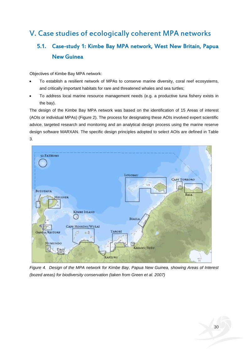
30
V. Case studies of ecologically coherent MPA networks
5.1. Case-study 1: Kimbe Bay MPA network, West New Britain, Papua
New Guinea
Objectives of Kimbe Bay MPA network:
To establish a resilient network of MPAs to conserve marine diversity, coral reef ecosystems,
and critically important habitats for rare and threatened whales and sea turtles;
To address local marine resource management needs (e.g. a productive tuna fishery exists in
the bay).
The design of the Kimbe Bay MPA network was based on the identification of 15 Areas of interest
(AOIs or individual MPAs) (Figure 2). The process for designating these AOIs involved expert scientific
advice, targeted research and monitoring and an analytical design process using the marine reserve
design software MARXAN. The specific design principles adopted to select AOIs are defined in Table
3.
Figure 4. Design of the MPA network for Kimbe Bay, Papua New Guinea, showing Areas of Interest
(bozed areas) for biodiversity conservation (taken from Green et al. 2007)
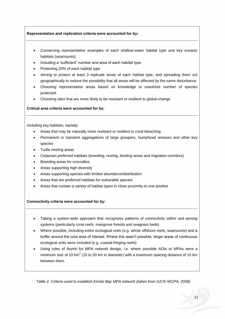
31
Representation and replication criteria were accounted for by:
Conserving representative examples of each shallow-water habitat type and key oceanic
habitats (seamounts)
Including a “sufficient” number and area of each habitat type
Protecting 20% of each habitat type
Aiming to protect at least 3 replicate areas of each habitat type, and spreading them out
geographically to reduce the possibility that all areas will be affected by the same disturbance
Choosing representative areas based on knowledge to maximize number of species
protected
Choosing sites that are more likely to be resistant or resilient to global change
Critical area criteria were accounted for by:
Including key habitats, namely:
Areas that may be naturally more resistant or resilient to coral bleaching
Permanent or transient aggregations of large groupers, humphead wrasses and other key
species
Turtle nesting areas
Cetacean preferred habitats (breeding, resting, feeding areas and migration corridors)
Breeding areas for crocodiles
Areas supporting high diversity
Areas supporting species with limited abundance/distribution
Areas that are preferred habitats for vulnerable species
Areas that contain a variety of habitat types in close proximity to one another
Connectivity criteria were accounted for by:
Taking a system-wide approach that recognizes patterns of connectivity within and among
systems (particularly coral reefs, mangrove forests and seagrass beds)
Where possible, including entire ecological units (e.g. whole offshore reefs, seamounts) and a
buffer around the core area of interest. Where this wasn’t possible, larger areas of continuous
ecological units were included (e.g. coastal fringing reefs)
Using rules of thumb for MPA network design, i.e. where possible AOIs or MPAs were a
minimum size of 10 km2 (10 to 20 km in diameter) with a maximum spacing distance of 15 km
between them.
Table 2. Criteria used to establish Kimbe Bay MPA network (taken from IUCN-WCPA, 2008)

32
5.2. Case-study 2: Channel Islands, California MPA network
The MPA network in the Channel Islands National Marine Sanctuary (CINMS) was primarily
established to restore the integrity of the ecosystem and to rebuild collapsed fish populations (Davis,
2005).
The Marine Life Protection Act (MLPA) that came into force in 1999. It required the preparation and
implementation of the Marine Life Protection Program throughout the state of California. One of the
goals of this plan was to improve and manage the state’s MPAs as a network. Following discussions
between representatives from the local community, federal, state and local government agencies, the
final recommendation was to create a network of 10 MPAs that constituted approximately 20% of the
state and federal waters within the National Marine Sanctuary (Figure 3). The establishment of MOAs
within state waters became effective in April 2003, whereas the establishment of MPAs in the federal
water was put in place in July 2007. The criteria used to design the network are described in Table 4.
Figure 5. Marine reserve network map for the Channel Islands National Marine Sanctuary, California
(taken from: http://channelislands.noaa.gov/marineres/main.html)
MARXAN was used to identify areas of high habitat diversity and areas most likely to represent all
habitats within the smallest area possible. Data on representative and unique habitats, and
distributions of vulnerable species was used to identify reserve network scenarios with the potential to
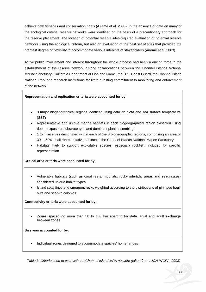
33
achieve both fisheries and conservation goals (Airamé et al. 2003). In the absence of data on many of
the ecological criteria, reserve networks were identified on the basis of a precautionary approach for
the reserve placement. The location of potential reserve sites required evaluation of potential reserve
networks using the ecological criteria, but also an evaluation of the best set of sites that provided the
greatest degree of flexibility to accommodate various interests of stakeholders (Airamé et al. 2003).
Active public involvement and interest throughout the whole process had been a driving force in the
establishment of the reserve network. Strong collaborations between the Channel Islands National
Marine Sanctuary, California Department of Fish and Game, the U.S. Coast Guard, the Channel Island
National Park and research institutions facilitate a lasting commitment to monitoring and enforcement
of the network.
Representation and replication criteria were accounted for by:
3 major biogeographical regions identified using data on biota and sea surface temperature
(SST)
Representative and unique marine habitats in each biogeographical region classified using
depth, exposure, substrate type and dominant plant assemblage
1 to 4 reserves designated within each of the 3 biogeographic regions, comprising an area of
30 to 50% of all representative habitats in the Channel Islands National Marine Sanctuary
Habitats likely to support exploitable species, especially rockfish, included for specific
representation
Critical area criteria were accounted for by:
Vulnerable habitats (such as coral reefs, mudflats, rocky intertidal areas and seagrasses)
considered unique habitat types
Island coastlines and emergent rocks weighted according to the distributions of pinniped haul-
outs and seabird colonies
Connectivity criteria were accounted for by:
Zones spaced no more than 50 to 100 km apart to facilitate larval and adult exchange between zones
Size was accounted for by:
Individual zones designed to accommodate species’ home ranges
Table 3. Criteria used to establish the Channel Island MPA network (taken from IUCN-WCPA, 2008)
34
5.3. Case study 3: Commonwealth marine reserves network, Australia
In 1998, the Commonwealth and state and territory governments committed to the creation of a
National Representative System of Marine Protected Areas (NRSMPA) by 2012. This commitment
was reaffirmed at the World Summit on Sustainable Development in 2002. The Australian Government
has established additional Commonwealth marine reserves around Australia, taking the number of
marine reserves from 27 to 60. The NRSMPA covers some 3.1 million square kilometres of ocean and
is the largest system of marine reserves in the world (Figure 4).
The overall goal of the NRSMPA is to establish and effectively manage a comprehensive, adequate
and representative system of marine reserves to contribute to the long-term conservation of marine
ecosystems and to protect marine biodiversity. This system aims to be:
comprehensive by including the full range of ecosystems recognised at an appropriate scale
within and across each bioregion;
adequate by having the required level of reservation to ensure the ecological viability and
integrity of populations, species and communities;
representative by reasonably reflecting the biotic diversity of marine ecosystems.
The Australian Government developed a set of goals and principles to provide a consistent framework
for identifying new marine reserves in Commonwealth waters (Table 5). Scientific data and information
provided the foundation for identifying and designing new Commonwealth marine reserves. The types
of information were varied and covered biophysical data, information about the location and
distribution of human activities in each marine region and information provided by industry, managers
and regulators, ocean users and stakeholders in each marine region.
The Commonwealth Marine Reserves networks have been designed to minimise both social and
economic impacts while creating a system of marine protected areas that represents Australia's
diversity of marine ecosystems and habitats. The work of the Australian Bureau of Agricultural and
Resource Economics and Sciences (ABARES), together with the assistance of the commercial fishing
industry assessed at both the direct and indirect impacts of the proposed networks on the fishing
industry (including commercial and charter fishing) and the potential impacts on related communities.
Hence, the social and economic implications of each of the regional marine reserves network
proposals played an important role in the design of the networks.
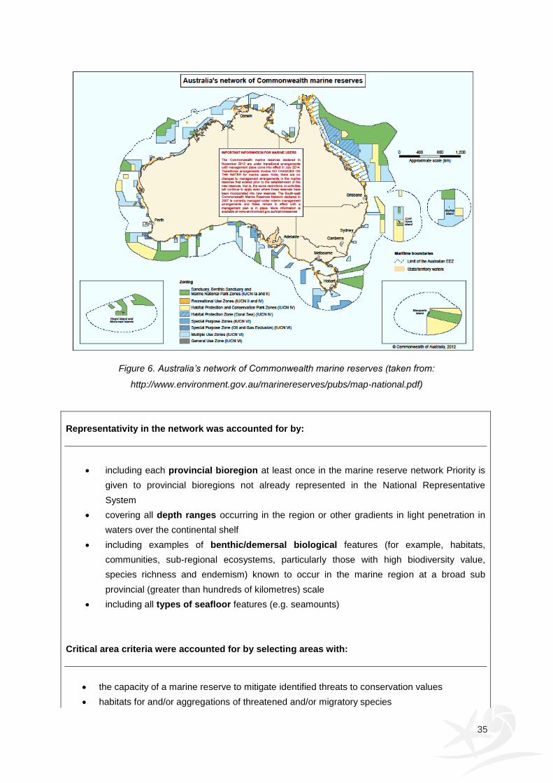
35
Figure 6. Australia’s network of Commonwealth marine reserves (taken from:
http://www.environment.gov.au/marinereserves/pubs/map-national.pdf)
Representativity in the network was accounted for by:
including each provincial bioregion at least once in the marine reserve network Priority is
given to provincial bioregions not already represented in the National Representative
System
covering all depth ranges occurring in the region or other gradients in light penetration in
waters over the continental shelf
including examples of benthic/demersal biological features (for example, habitats,
communities, sub-regional ecosystems, particularly those with high biodiversity value,
species richness and endemism) known to occur in the marine region at a broad sub
provincial (greater than hundreds of kilometres) scale
including all types of seafloor features (e.g. seamounts)
Critical area criteria were accounted for by selecting areas with:
the capacity of a marine reserve to mitigate identified threats to conservation values
habitats for and/or aggregations of threatened and/or migratory species
36
the occurrence of known small-scale (tens of kilometres) ecosystems associated with the
benthic/demersal environment
the occurrence of listed heritage sites (where inclusion in the marine reserve network would
improve administration of protection regimes)
Replication criteria were accounted for by:
replicating features wherever possible within the system of marine reserves (that is, included more than once)
Size and shape considerations included:
selecting the least number of separate marine reserves (that is, a smaller number of larger
marine reserves rather than many small marine reserves) to maximize conservation
outcomes
accounting for the inclusion of connectivity corridors and biological dispersal patterns within
and across marine reserves
boundary lines should be simple, as much as possible following straight latitudinal/longitudinal
lines
boundary lines should be easily identifiable, where possible coinciding with existing regulatory
boundaries
the size and shape of each area should be set to minimize socio-economic costs (see also
Zoning)
Zoning considerations in developing the regional systems of marine reserves included:
selecting some highly protected areas (IUCN Categories I and II) in each provincial bioregion
considering the threat that specific activities pose to the conservation objectives of each marine reserve. Hence, zoning ensures that the conservation objectives of the area are protected, taking into account a precautionary approach to threats as well as the relative costs and benefits (economic, social and environmental) of different zoning arrangements
Table 4. Criteria used to establish the Channel Island MPA network (adapted from
http://www.environment.gov.au/coasts/mbp/publications/general/goals-nrsmpa.html)
37
5.4. Case study 4: Towards establishing an ecologically coherent
network in the UK: Marine Conservation Zones
Under international (OSPAR Convention, The World Summit on Sustainable Development, The
Convention on Biological Diversity), regional (EU Marine Strategy Framework Directive) and national
(Marine and Coastal Access Act 2009) commitments, the UK Government and Devolved
Administrations are committed to creating an ecologically coherent network of MPAs. The MPA
network will comprise of existing and new MPAs including Special Areas of Conservation (SACs),
Special Protection Areas (SPAs), the marine components of Sites of Special Scientific Interest
(SSSIs), Ramsar sites and Marine Conservation Zones (MCZs) that will be designated under the
Marine and Coastal Access Act 2009.
In 2009, the Joint Nature Conservation Committee (JNCC) and Natural England set up a project to
give sea-users and interest groups (stakeholders), from local fishermen to international corporations,
the opportunity to recommend possible MCZs to UK Government. The project is known as the Marine
Conservation Zone Project and consisted of four regional MCZ projects covering the south-west
(Finding Sanctuary), Irish Sea (Irish Sea Conservation Zones), North Sea (Net Gain) and south-east
(Balanced Seas). The criteria and principles set by government policy and used by regional
stakeholder groups to identify sites that will protect the range of marine biodiversity within the regional
MCZ project areas and contribute to an ecologically coherent MPA network are given in Table 6.
In September 2011, these regional MCZ projects recommended 127 MCZs including 65 reference
areas to JNCC and Natural England (Figure 5). The recommended MCZs cover approximately 15% of
English territorial waters and UK offshore waters adjacent to England, Wales and Northern Ireland).
Representativity in the network was accounted for by including:
examples of each of the 23 broad-scale habitats
examples of each of the 22 habitats of conservation importance
examples of each of the 29 low or limited mobility species of conservation importance
the three highly mobile species for which MCZs are an appropriate tool within MPAs in each
regional MCZ project area
Replication within the network was achieved by including:
at least two separate examples of each broad-scale habitat, and at least three to five
separate examples of each feature of conservation importance in MPAs within each regional
MCZ project area
Adequacy within the network was accounted for by protecting:
38
between 11 – 42% of each broad-scale habitat (EUNIS Level 3 habitats) within MPAs for each of the regional MCZ project areas
Size considerations of MPAs in the network:
MCZs for broad-scale habitats should have a minimum diameter of 5 km with the average
size being between 10 and 20 km in diameter
For features of conservation importance (FOCI), habitat- and species-specific
recommendations for the minimum diameter of the MCZ was provided
Connectivity criteria were accounted for by:
Using species-specific dispersal distances or critical areas for life-cycles of FOCI to determine
the spacing between MPAs
In the absence of specific information, MPAs of similar habitat should be separated by no
more than 40 – 80km
Ensuring that MPAs are well distributed across the regional MCZ project areas
Protection level of each MPA, which determines the range of activities prohibited and allowed
within the MPA were set by:
Considering the current condition of the features
Considering the pressures to which the features are sensitive
Including at least one viable reference area within each of the four regional MCZ project areas
where all extraction, deposition or human-derived disturbance is prevented
Table 5. Criteria used to identify Marine Conservation Zones in England and Wales which will
contribute towards creating an ecologically coherent network of MPAs in the UK. (adapted from NE
and JNCC, 2010)

39
Figure 7. Recommended Marine Conservation Zones by each of the four regional MCZ projects
Source: http://www.pbo.co.uk/news/529658/marine-protection-reports-go-to-government
40
References
Abesamis, R.A., Alcala, A.C. and Russ, G.R. 2006. How much does the fishery at Apo Island benefit from spillover of adult fish from the adjacent marine reserve? Fisheries Bulletin, 104: 360 – 375. Airamé, S., Dugan, J.E., Lafferty, K.D., Leslie, H., McArdle, D.A. and Warner, R.R. 2003. Applying ecological criteria to marine reserve design: A case study from the California Channel Islands. Ecological Applications, 13: S170-S184. Ardron, J.A. 2008. Three initial OSPAR tests of ecological coherence: heuristics in a data-limited situation. ICES Journal of Marine Science, 65: 1527-1533. Arvanitidis, C., Somerfield, P.J., Rumohr, H., et al, 2009. Biological geography of the European seas: results from the MacroBen database. Marine Ecology Progress Series 382, 265–278. Australian Government. 2013. Commonwealth marine reserves. Available from: http://www.environment.gov.au/marinereserves/index.html
Barber, C. V. 2004. Designing protected area systems for a changing world. In C. V. Barber, K. R. Miller and M. Bones (Eds.) Securing Protected Areas in the Face of Global Change: Issues and Strategies. IUCN. Gland, Switzerland and Cambridge, UK. Beaugrand, G., Ibanez, F., Reid, P.C., 2000. Spatial, seasonal and long-term fluctuations of plankton in relation to hydroclimatic features in the English Channel, Celtic Sea and Bay of Biscay. Marine Ecology Progress Series 200, 93–102. Beck, M.W., Heck, Jr. K.L., Able, K.W., Childers, D.L., Eggleston, D.B., Gillanders, B.M., Halpern, B., Hays, C.G., Hoshino, K., Minello, T.J., Orth, R.J., Sheridan, P.F. and Weinstein, M.P. 2001. The identification, conservation, and management of estuarine and marine nurseries for fish and invertebrates. BioScience, 51: 633-641. Bellwood, D.R., Hoey, A.S. and Choat, H. 2003. Limited functional redundancy in high diversity systems: resilience and ecosystem function on coral reefs. Ecology Letters, 6: 281–85. Bennet, G. and Wit, P. 2001. The Development and Application of Ecological Networks. A Review of Proposals, Plans and Programmes. AIDEnvironment & IUCN. Amsterdam, Holland: & Cambridge, UK & Gland, Switzerland. Beukers-Stewart, B.D., Vause, B.J., Mosley, M.W.J., Rossetti, H.L., Brand, A.R. 2005. Benefits of closed area protection for a population of scallops. Marine Ecology Progress Series, 298: 189–204. Blyth, R.E., Kaiser, M.J., Edwards-Jones, G., Hart, P.J.B. 2002. Voluntary management in an inshore fishery has conservation benefits. Environmental Conservation, 29(4): 493-508. Borrini-Feyerabend, G., Kothary, A. and Oviedo, G. 2004. Indigenous and Local Communnities and Protected Areas: Towards Equity and Enhanced Conservation. IUCN. Gland, Switzerland and Cambridge, UK. Cathpole, R.D.J. 2012. Ecological Coherence Definitions in Policy and Practice - Final Report. SNH Contract Report. Available from: http://www.rogercatchpole.net/index_htm_files/Catchpole,%20R.D.J.%202012%20-%20Ecological%20Coherence%20Definitions%20in%20Policy%20and%20Practice.%20SNH%20Contract%20Report..pdf CBD. Convention on Biological Diversity. 2004. Programme of Work on Protected Areas. Available from: http://www.cbd.int/programmes/pa/pow-goals-alone.pdf CBD. Convention on Biological Diversity. 2010. COP 10. Decision X/31. Protected areas. Available from: http://www.cbd.int/decision/cop/?id=12297

41
Chape, S., M. Spalding, M. and Jenkins, M.D. 2008. The World’s Protected Areas: Status, Values and Prospects in the 21
st Century. Berkeley, USA: University of California Press.
Chiappone, M., Sealey, K.M., Coleman, F. and Travis, J. 2000. Marine reserve design criteria and measures of success: Lessons learned from the Exuma Cays Land and Sea Park, Bahamas. Bulletin of Marine Science, 66: 691-705. Cicin-Sain, B. and Belfiore, S. 2005. Linking marine protected areas to integrated coastal and ocean management: A review of theory and practice. Ocean & Coastal Management, 48: 847-868. Cinner, J., Marnane, M.J., McClanahan, T.R. and Almany, G.R. 2005. Periodic closures as adaptive coral reef management in the Indo-Pacific. Ecology and Society, 11: 1-31. Connor, D.W., Breen, J., Champion, A., Gilliland, P.M., Huggett, D., Johnston, C., Laffoley, D. d’A., Lieberknecht, L., Lumb, C., Ramsay, K., and Shardlow, M. 2002. Rationale and criteria for the identification of nationally important marine nature conservation features and areas in the UK. Version 02.11. Peterborough, Joint Nature Conservation Committee (on behalf of the statutory nature conservation agencies and Wildlife and Countryside Link) for the DEFRA Working Group on the Review of Marine Nature Conservation. Connor, D.W., Allen, J.H., Golding, N., Lieberknecht, L.M., Northen, K.O. and Reker, J.B. 2003. The National Marine Habitat Classification for Britain and Ireland. Version 03.02. JNCC, Peterborough ISBN 1 86107 546 4 (internet version available online at www.jncc.gov.uk/MarineHabitatClassification). Cote, I.M. and Darling, E.S. 2010. Rethinking ecosystem resilience in the face of climate change. PLoS Biology 8(7): e1000438. doi:10.1371/journal.pbio.1000438 Cowen, R.K. and Sponaugle, S. 2009. Larval Dispersal and Marine Population Connectivity. Annual Review of Marine Science, Vol. 1: 443-466. Crowder, L.B., Lyman, S.J., Figueira, W.F. and Priddy, J. 2000. Source-sink population dynamics and the problem of siting marine reserves. Bulletin of Marine Science, 66(3), 799-820. Davis, G. E. 2005. Science and Society: Marine Reserve Design for the California Channel Islands. Conservation Biology 19(6): 6. Day, J.C. and Roff, J. C. 2000. Planning for Representative Marine Protected Areas: A Framework for Canada's Oceans. Report prepared for World Wildlife Fund Canada, Toronto. Available from: http://assets.wwfca.bluegecko.net/downloads/planning_for_representative_mpas.pdf DEFRA, 2010. Guidance on selection and designation of Marine Conservation Zones (Note 1). Guidance on the proposed approach to the selection and designation of Marine Conservation Zones under Part 5 of the Marine and Coastal Access Act. Available at: http://archive.defra.gov.uk/environment/biodiversity/marine/documents/guidance-note1.pdf DEFRA, 2012. UK contribution to ecologically coherent MPA network in the North East Atlantic: Joint administrations statement Defra, DOE, Scottish Government, Welsh Government. Available from: http://archive.defra.gov.uk/environment/marine/documents/protected/mpa-network-joint-admin-statement-201212.pdf Dinter W.P. 2001. Biogeography of the OSPAR Maritime Area. A synopsis and synthesis of biogeographical distribution patterns described for the north-east Atlantic. Bonn, Germany: Federal Agency for Nature Conservation. Dudley, N. (Ed.) 2008. Guidelines for Applying Protected Areas Management Categories. IUCN. Gland, Switzerland.
42
EU. European Union. 1979. Birds Directive. Available from (amended version): http://eur-lex.europa.eu/LexUriServ/LexUriServ.do?uri=OJ:L:2010:020:0007:0025:EN:PDF EU. European Union. 1992. Habitats Directive. Available from (amended version): http://eur-lex.europa.eu/LexUriServ/LexUriServ.do?uri=CONSLEG:1992L0043:20070101:EN:PDF EU. European Union. 2008. Marine Strategy Framework Directive. Available from: http://eur-lex.europa.eu/LexUriServ/LexUriServ.do?uri=OJ:L:2008:164:0019:0040:EN:PDF Fernandes, L., Day, J.O.N., Lewis, A., Slegers, S., Kerrigan, B., Breen, D., Cameron, D., Jago, B., Hall, J., Lowe, D., Innes, J., Tanzer, J., Chadwick, V., Thompson, L., Gorman, K., Simmons, M., Barnett, B., Sampson, K., De’Ath, G., Mapstone, B., Marsh, H., Possingham, H., Ball, I., Ward, T., Dobbs, K., Aumend, J., Slater, D. and Stapleton, K. 2005. Establishing Representative No-Take Areas in the Great Barrier Reef: Large-Scale Implementation of Theory on Marine Protected Areas. Conservation Biology, 19(6): 1733-1744. Frankham, R. 199.5 Effective population-size adult-population size ratios in wildlife: a review. Genetic Research, 66: 95-107. Gaines, S.D., White, C., Carr, M.H. and Palumbi, S.R. 2010. Designing marine reserve networks for both conservation and fisheries management. PNAS, 107(43): 18286-18293. García-Charton, J.A., Perez-Ruzafa, A., Sanchez-Jerez, P., Bayle-Sempere, J.T., Renones, O., Moreno-Lampreave, D. 2004. Multi-scale heterogeneity, habitat structure and the effect of marine reserves on Western Mediterranean rocky reef fish assemblages. Marine Biology, 144: 161–182. Golding N., Vincent M.A. & Connor D.W. 2004. Irish Sea Pilot - Report on the development of a Marine Landscape classification for the Irish Sea. Joint Nature Conservation Committee, Peterborough, JNCC report No. 346, pp. Government of Canada. 2005. Canada's Federal Marine Protected Areas Strategy. Fisheries and Oceans Canada, Canada. Graham, J., Amos, B. and Plumtre, T. 2003. Governance principles for protected areas in the 21st century. A discussion paper-phase 2. Institute on Governance. Ottawa. Grafton, R. Q. and T. Kompas. 2005. Uncertainty and the active adaptive management of marine reserves. Marine Policy, 29:471-479. Green, A., Lokani, P., Sheppard, S., Almany, J., Keu, S., Aitsi, J., Warku Karvon, J., Hamilton, R. and Lipsett-Moore, G. 2007. Scientific design of a resilient network of Marine Protected Areas. Kimbe Bay, West New Britain, Papua New Guinea. TNC Pacific Island Countries Report No. 2/07. Halpern, B.S., Gaines, S.D. and Warner, R.R. 2004. Confounding effects of the export of production and the displacement of fishing effort from marine reserves. Ecological Applications, 14: 1248-1256. Halpern, B.S., Lester, S.E. and McLeod, K.L. 2010. Placing marine protected areas onto the ecosystem-based management seascape. PNAS, 107(43): 18312-18317. HELCOM. Helsinki Commission. 2003a. Joint Ministerial Declaration HELCOM/OSPAR. Available from: http://www.helcom.fi/stc/files/MinisterialDeclarations/HelcomOsparMinDecl2003.pdf HELCOM. Helsinki Commission. 2003b. Joint HELCOM/OSPAR Work Programme on Marine Protected Areas. Available from: http://www.helcom.fi/stc/files/BremenDocs/Joint_MPA_Work_Programme.pdf HELCOM. Helsinki Commission. 2010. Towards an ecologically coherent network of well-managed Marine Protected Areas – Implementation report on the status and ecological coherence of the HELCOM BSPA network. Baltic Sea Environment Proceedings No. 124B. Available from: http://www.helcom.fi/stc/files/Publications/Proceedings/bsep124B.pdf
43
Hiddink, J.G. 2003. Modelling the adaptive value of intertidal migration and nursery use in the bivalve Macoma balthica. Marine Ecology Progress Series, 252: 173-185. Hill, J., Pearce, B., Georgiou, L.,Pinnion, J. and Gallyot, J. 2010. Meeting the MPA Network Principle of Viability: Feature specific recommendations for species and habitats of conservation importance. Natural England Commissioned Reports, Number 043. Hockings, M., Stolton, S., Leverington, F., N. Dudley, N. and Courrau, J. 2006. Evaluating effectiveness. A framework for assessing management effectiveness of protected areas. 2.ª ed. Gland, Switzerland & Cambridge, UK. IUCN.
Holling CS. 1973. Resilience and stability of ecological systems. Annual review of ecology and Systematics, 4: 1–23. Hughes TP, Bellwood DR, Folke C, et al. 2005. New paradigms for supporting resilience of marine ecosystems. Trends in Ecology and Evolution, 20: 380–86. ICES. International Council for the Exploration of the Sea. ICES Divisions. In Suarez-de Vivero, J.L. (Ed.). 2011. An Atlas of Marine Spatial Planning. Available from: http://www.marineplan.es/en/ATLAS_13_06_11_EN.pdf IHO. International Hydrographic Organization. IHO Marine Regions. In Suarez-de Vivero, J.L. (Ed.). 2011. An Atlas of Marine Spatial Planning. Available from: http://www.marineplan.es/en/ATLAS_13_06_11_EN.pdf IUCN 2003 Recommendation 5.22. 5th IUCN World Parks Congress, Durban, South Africa (8-17th September, 2003). IUCN World Commission on Protected Areas (IUCN-WCPA) (2008). Establishing Marine Protected Area Networks—Making It Happen. IUCN-WCPA, National Oceanic and Atmospheric Administration and The Nature Conservancy. Washington, D.C. Jackson, E.L., Hiscock, K., Evans, J., Seeley, B. and Lear, D. 2008. Investigating the existing coverage and subsequent gaps in protection and providing guidance on representativity and replication for a coherent network of Marine Protected Areas in England’s territorial waters. Plymouth: Marine Life Information Network (MarLIN), Marine Biological Association of the UK. Natural England Commissioned Reports, Number 018. Jameson, S. C., Tupper, M.H. and Ridley, J.M. 2002. The three screen doors: Can marine “protected” areas be effective? Marine Pollution Bulletin, 44: 1.177-1.183. Jones, G.P., Srinivasan, M. and Almany, G.R. 2007. Population Connectivity and Conservation of Marine Biodiversity. Oceanography, 20(3): 100-111. Jongman, R.H.M. 2002. Homogeneization and fragmentation of the European landscape: ecological consequences and solutions. Landscape and Urban Planning, 58: 211-221. Joint Nature Conservation Committee. 1998. Guidelines for selection of biological SSSIs: Rationale, operational approach and criteria, Detailed guidelines for habitats and species groups, Peterborough: Joint Nature Conservation Committee. Lawton, J.H., Brotherton, P.N.M., Brown, V.K., Elphick, C., Fitter, A.H., Forshaw, J., Haddow, R.W., Hilborne, S., Leafe, R.N., Mace, G.M., Southgate, M.P., Sutherland, W.J., Tew, T.E., Varley, J., and Wynne, G.R. 2010. Making Space for Nature: a review of England’s wildlife sites and ecological network. Report to Defra. Available from: http://archive.defra.gov.uk/environment/biodiversity/documents/201009space-for-nature.pdf Lockwood, D.R., Hastings, A. and Botsford, L.W. 2002. The effect of dispersal patterns on marine reserves: Does the tail wag the dog? Theoretical Population Biology, 61: 297-309.
44
Longhurst, A. 2007. Longhurst Biogeographical provinces. Available from: http://comlmaps.org/how-to/layers-and-resources/boundaries/longhurst-biogeographical-provinces Mosquera, I., Cote, I.M., Jennings, S., Reynolds, J.D. 2000. Conservation benefits of marine reserves for fish populations. Animal Conservation, 4: 321 – 332. NE. Natural England. 2013. Our work. Conservation. Designations. Sites of Special Scientific Interest. Available from: http://www.naturalengland.org.uk/ourwork/conservation/designations/sssi/default.aspx NE and JNCC. Natural England and the Joint Nature Conservation Committee. 2010. Marine conservation zone project: Ecological network guidance, 66pp. McLeod, E., Salm, R., Green, A. and Almany, J. 2009. Designing marine protected area networks to address the impacts of climate change. Frontiers in Ecology and the Environment, 7(7): 362–370. Mumby, P.J., Edwards, A.J., Arias-Gonzalez, J.E., Lindeman, K.C., Blackwell, P.G., Gall, A., Gorczynska, M.I., Harborne, A.R., Pescod, C.L., Renken, H., Wabnitz, C.C.C. and Llewellyn, G. 2004. Mangroves enhance the biomass of coral reef fish communities in the Caribbean. Nature, 427: 533-536. Nyström M and C Folke. 2001. Spatial resilience of coral reefs. Ecosystems, 4: 406–17. Occhipinti-Ambrogi, A. 2007. Global change and marine communities: Alien species and climate change. Marine Pollution Bulletin, 55: 342-352. OSPAR. Guidelines for the Identification and selection of marine protected areas in the OSPAR maritime area. London; OSPAR Commission, 2003-7. OSPAR. Convention for the Protection of the Marine Environment of the Northeast Atlantic. 2006. Guidance on developing an ecologically coherent network of OSPAR marine protected areas. Reference number 2006-3. Available from: www.ospar.org OSPAR. Convention for the Protection of the Marine Environment of the Northeast Atlantic. 2007. Background Document to Support the Assessment of Whether the OSPAR Network of Marine Protected Areas is Ecologically Coherent. OSPAR Biodiversity Series, 320. Available from: http://www.ospar.org/documents/dbase/publications/p00320_ecological%20coherence.pdf OSPAR. Convention for the Protection of the Marine Environment of the Northeast Atlantic. 2008a. A matrix approach to assessing the ecological coherence of the OSPAR MPA network. Meeting of the Working Group on Marine Protected Areas, Species and Habitats (MASH), 21-24 October, Baiona (Spain). Available from: http://jncc.defra.gov.uk/pdf/0506_UK_OSPARMPAsEcoCoherenceAssessmt.pdf OSPAR. Convention for the Protection of the Marine Environment of the Northeast Atlantic. 2008b. Background document on three initial spatial tests used for assessing the ecological coherence of the OSPAR MPA network. OSPAR Biodiversity Series, 360. Available from: http://www.ospar.org/documents/dbase/publications/p00360_3_initial_tests_ospar_mpa_network%20.pdf OSPAR. Convention for the Protection of the Marine Environment of the Northeast Atlantic. 2010. OSPAR Recommendation 2010/2 on amending Recommendation 2003/3 on a network of Marine Protected Areas. Available from: http://www.ospar.org/v_measures/browse.asp?preset=1&menu=00520417000000_000000_000000&v0_0=&v1_0=title%2Creferencenumber%2Cdateofadoption&v2_0=&v0_1=&v1_1=referencenumber&v2_1=&v0_2=2010%2C+Bergen&v1_2=dateofadoption&v2_2=&order=&v1_3=&v2_3= Palumbi, S.R. 2003. Population genetics, demographic connectivity, and the design of marine reserves. Ecological Applications, 13(1): S146-S158.
45
Palumbi, S.R. 2004. Marine reserves and ocean neighbourhoods: The spatial scale of marine populations and their management. Annual Review of Environment and Resources, 29:31-68. Piekäinen, H. and Korpinen, S. 2008. Towards an Assessment of ecological coherence of the marine protected areas network in the Baltic Sea region. BALANCE Interim Report No. 25. Available from: http://balance-eu.org/xpdf/balance-interim-report-no-25.pdf Pipitone, C., Badalamenti, F., D’Anna, G., Patti, B. 2000. Fish biomass increase after a four-year trawl ban in the Gulf of Castellammare (NW Sicily, Mediterranean Sea). Fisheries Research, 48: 23-30. Pullin, A. 2002. Conservation Biology. Cambridge University Press. Cambridge, UK. Ramsar Convention. 1971. Convention on Wetlands of International Importance especially as Waterfowl Habitat. Convention texts. Available from: http://www.ramsar.org/cda/en/ramsar-documents-texts-convention-on/main/ramsar/1-31-38%5E20671_4000_0__ Roberts, C.M., Branch, G., Bustamante, R.H., Castilla, J.C., Dugan , J., Halpern, B.S., Lafferty, K.D., Leslie, H., Lubchenco, J., McArdle, D., Ruckelshaus, M. and Warner, R.R. 2003. Application of ecological criteria in selecting marine reserves and developing reserve networks. Ecological Applications, 13(1): S215-S228. Roberts, C.M., Hawkins, J.P., Fletcher, J., Hands, S., Raab, K. and Ward, S. 2010. Guidance on the size and spacing of Marine Protected Areas in England. Natural England Commissioned Report NECR037. Available from: publications.naturalengland.org.uk/file/73037 Roberts, C.M. and Sargant, H. 2002. Fishery benefits of fully protected marine reserves: why habitat and behaviour are important. Natural Resource Modelling, 15: 487-507. Rodríguez-Rodríguez, D. 2012. Perception, use and valuation of protected areas by local populations in an economic crisis context. Environmental Conservation, 39: 162-171. Roff, J.C. and Taylor, M.E. 2000. Viewpoint. National frameworks for marine conservation - hierarchal geophysical approach. Aquatic Conservation: Marine and Freshwater Ecosystems, 10: 209-223. Rondinini, C. 2010. Meeting the MPA network design principles of representation and adequacy: developing species-area curves for habitats. JNCC Report No. 439. Ruzycki, J.R. and Wurtsbaugh, W.A. 1999. Ontogenetic habitat shifts of juvenile bear lake sculpin. Transactions of the American Fisheries Society, 128: 1201-1212. Sadovy, Y. 2006. Protecting the spawning and nursery habitats of fish: the use of MPAs to safeguard critical life-history stages for marine life. MPA News: International News and Analysis on Marine Protected Areas 8: 1–3. Sala, E., Aburto-Oropeza, O., Paredes, G., Parra, I., Barrera, J.C. and Dayton, P.K. 2002. A general model for designing networks of marine reserves. Science, 298: 1,991-1,993. Sciberras, M. 2012. Marine Protected Areas: Efficacy, Implementation and Management. PhD thesis, Bangor University, 246 pp. Secretariat of the Convention on Biological Diversity. 2004. Technical advice on the establisand management of a national system of marine and coastal protected areas. CBD Technical Series no.13, SCBD, 40 pp. Shanks, A.L., Grantham, B.A. and Carr, M.H. 2003. Propagule dispersal distance and the size and spacing of marine reserves. Ecological Applications, 13: S159-S169. Shanks, A.L. 2009. Pelagic larval duration and dispersal distance revisited. Biological Bulletin, 216: 373–385.

46
Spalding, M.D., Fox, H.E., Allen, G.R., Davidson, N., Ferdana, Z.A., Finlayson, M., Halpern, B.S., Jorge, M.A., Lombana, A., Lourie, S.A., Martin, K.D., McManus, E., Molnar, J., Recchia, C.A. and Robertson, J. 2007. Marine ecoregions of the world: A bioregionalization of coastal and shelf areas. Bioscience, 57(7): 573 – 583. Stevens, T. 2002. Rigor and Representativeness in Marine Protected Area Design. Coastal Management, 30(3), 237-248. Stobart, B., Warwick, R., González, C., Mallol, S., Díaz, D., Reñones, O., Goñi, R. 2009. Long-term and spillover effects of a marine protected area on an exploited fish community. Marine Ecology Progress Series, 384: 47-60. Sundblad, G., Bergström, U. and Sandström, A. 2011. Ecological coherence of marine protected area networks: a spatial assessment using species distribution models. Journal of Applied Ecology, 48(1): 112-120. Traill, L.W., Bradshaw, C.J.A. and Brook, B.W.. 2007. Minimum viable population size: A meta analysis of 30 years of published estimates. Biological Conservation. 139: p. 159- 166. Treml, E. A., P. N. Halpin, D. L. Urban and L. F. Pratson. 2007. Modelling population connectivity by ocean currents, a graph-theoretic approach for marine conservation. Landscape Ecology ONLINE FIRST: 18. UNEP-MED. 2009. IG.19/8. Annex II. Decision IG. 19/13. Regarding a regional working programme for the coastal and marine protected areas in the Mediterranean including the High Sea. Available from: http://www.rac-spa.org/sites/default/files/doc_cop/decision_ig_19_13_en.pdf UNEP-WCMC. 2008. National and Regional Networks of Marine Protected Areas: A Review of Progress. UNEP-WCMC, Cambridge. Available from: http://www.unep.org/regionalseas/publications/otherpubs/pdfs/MPA_Network_report.pdf University of Queensland. 2013. MARXAN. Available from: http://www.uq.edu.au/marxan/ Vincent, M.A., Atkins, S.M., Lumb, C.M., Golding, N., Lieberknecht, L.M. and Webster, M. 2004. Marine nature conservation and sustainable development - the Irish Sea Pilot. Report to Defra by the Joint Nature Conservation Committee, Peterborough, UK., pp. Wells, S., Burguess, N. and Ngusaru, A. 2007. Towards the 2012 marine protected area targets in Eastern Africa. Ocean & Coastal Management, 50: 67-83. Zhou, S.R. and Wang, G. 2006. One large, several medium, or many small? Ecological Modelling, 191: 513-520.
PANACHE is a project in collaboration between France and Britain. It aims at a better protection of the Channel marine environment through the networking of existing marine protected areas. The project’s five objectives:
Assess the existing marine protected areas network for its ecological coherence.
Mutualise knowledge on monitoring techniques, share positive experiences.
Build greater coherence and foster dialogue for a better management of marine protected areas.
Increase general awareness of marine protected areas: build common ownership and stewardship, through engagement in joint citizen science programmes.
Develop a public GIS database. France and Great Britain are facing similar challenges to protect the marine biodiversity in their shared marine territory: PANACHE aims at providing a common, coherent and efficient reaction.
PANACHE est un projet franco-britannique, visant à une meilleure protection de l’environnement marin de la Manche par la mise en réseau des aires marines protégées existantes. Les cinq objectifs du projet :
Étudier la cohérence écologique du réseau des aires marines protégées.
Mutualiser les acquis en matière de suivi de ces espaces, partager les expériences positives.
Consolider la cohérence et encourager la concertation pour une meilleure gestion des aires marines protégées.
Accroître la sensibilisation générale aux aires marines protégées : instaurer un sentiment d’appartenance et des attentes communes en développant des programmes de sciences participatives.
Instaurer une base de données SIG publique.
France et Royaume-Uni sont confrontés à des défis analogues pour protéger la biodiversité marine de l’espace marin qu’ils partagent : PANACHE vise à apporter une réponse commune, cohérente et efficace.
- www.panache.eu.com –
Financed by / financé par
PANACHE Project partners / Partenaires du projet PANACHE


![Valve terminal MPA-S - Festo USA · Pneumatic components description Valveterminalwith MPA-Spneumatics Type: MPA-FB MPA-CPI MPA-MPM-…and MPA-ASI-… 534241 1309f [8028624] Valve](https://img.pdfslide.us/doc/110x75/5c5bd85409d3f236368c6efe/valve-terminal-mpa-s-festo-usa-pneumatic-components-description-valveterminalwith.jpg)