Embed Size (px)
Citation preview

P:\Specproj\CG25132\Annual Assessment Reports\Spring 2003\files for CD\S4\S4 - Text and Photos.doc S4 – Willow Creek
Crest retrogression to fenceline since October 2002. Photo 1 (upper left) – July 2003
Facing north across the slide scarp, central portion, as seen during the July 2003 inspection. The point marked with the arrow is the portion of the crest that is closest to the fenceline. This portion of the scarp has retrogressed approximately 1 m since the Fall 2002 instrument readings and is now in contact with the fenceline. Please refer to Photo 5 for a closer view of this area.
Photo 2 (lower left) – May 2002 Facing north across the slide scarp, central portion, as seen during the May 2002 inspection.
Photo 3 (lower right) – May 2001 Facing north across the slide scarp, central portion, as seen during the May 2001 inspection.
P:\S
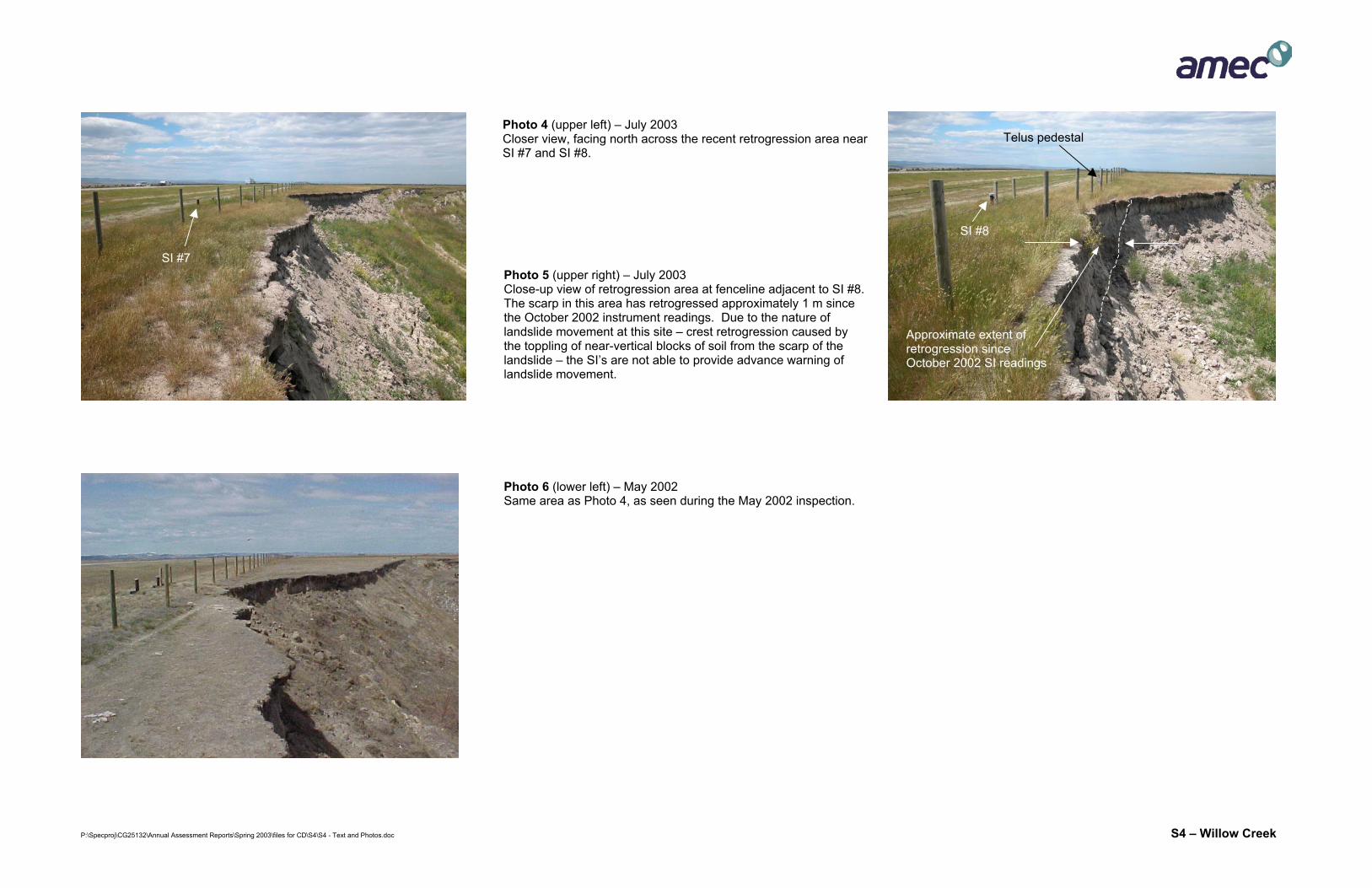
Photo 4 (upper left) – July 2003 Closer view, facing north across the recent retrogression area near SI #7 and SI #8.
Telus pedestal
SI #8
Approximate extent of retrogression since October 2002 SI readings
SI #7 Photo 5 (upper right) – July 2003 Close-up view of retrogression area at fenceline adjacent to SI #8. The scarp in this area has retrogressed approximately 1 m since the October 2002 instrument readings. Due to the nature of landslide movement at this site – crest retrogression caused by the toppling of near-vertical blocks of soil from the scarp of the landslide – the SI’s are not able to provide advance warning of landslide movement.
Photo 6 (lower left) – May 2002 Same area as Photo 4, as seen during the May 2002 inspection.
pecproj\CG25132\Annual Assessment Reports\Spring 2003\files for CD\S4\S4 - Text and Photos.doc S4 – Willow Creek

P:\Specproj\CG25132\Annual Assessment Reports\Spring 2003\files for CD\S4\S4 - Text and Photos.doc S4 – Willow Creek
Photo 7 (top) – July 2003 Facing south across retrogression area shown in Photos 4 and 5. This view shows the area that has retrogressed approximately 1 m since the October 2002 instrument readings and is now in contact with the fenceline adjacent to SI #8. This view also gives an indication of the relative positions of Willow Creek, the landslide complex, the landslide scarp/fenceline and the northbound lanes of Highway 2. As noted in the previous assessment reports, the SI’s will not give advance warning of the toppling of near-vertical blocks from the landslide scarp as the landslide continues to retrogress to the west in the future
Highway 2 (northbound lanes)
Landslide scarp, retrogressing via toppling of near-vertical blocks over time
Existing SI’s
SI #8
Photo 8 (lower left) – July 2003 General view of landslide scarp, facing south, as seen in July 2003.
Photo 9 (lower right) – May 2002 Same area as shown in Photo 8, from May 2002 inspection.
P:\Specproj\CG25132\Annual Assessment Reports\Spring 2003\files for CD\S4\S4 - Text and Photos.doc S4 – Willow Creek
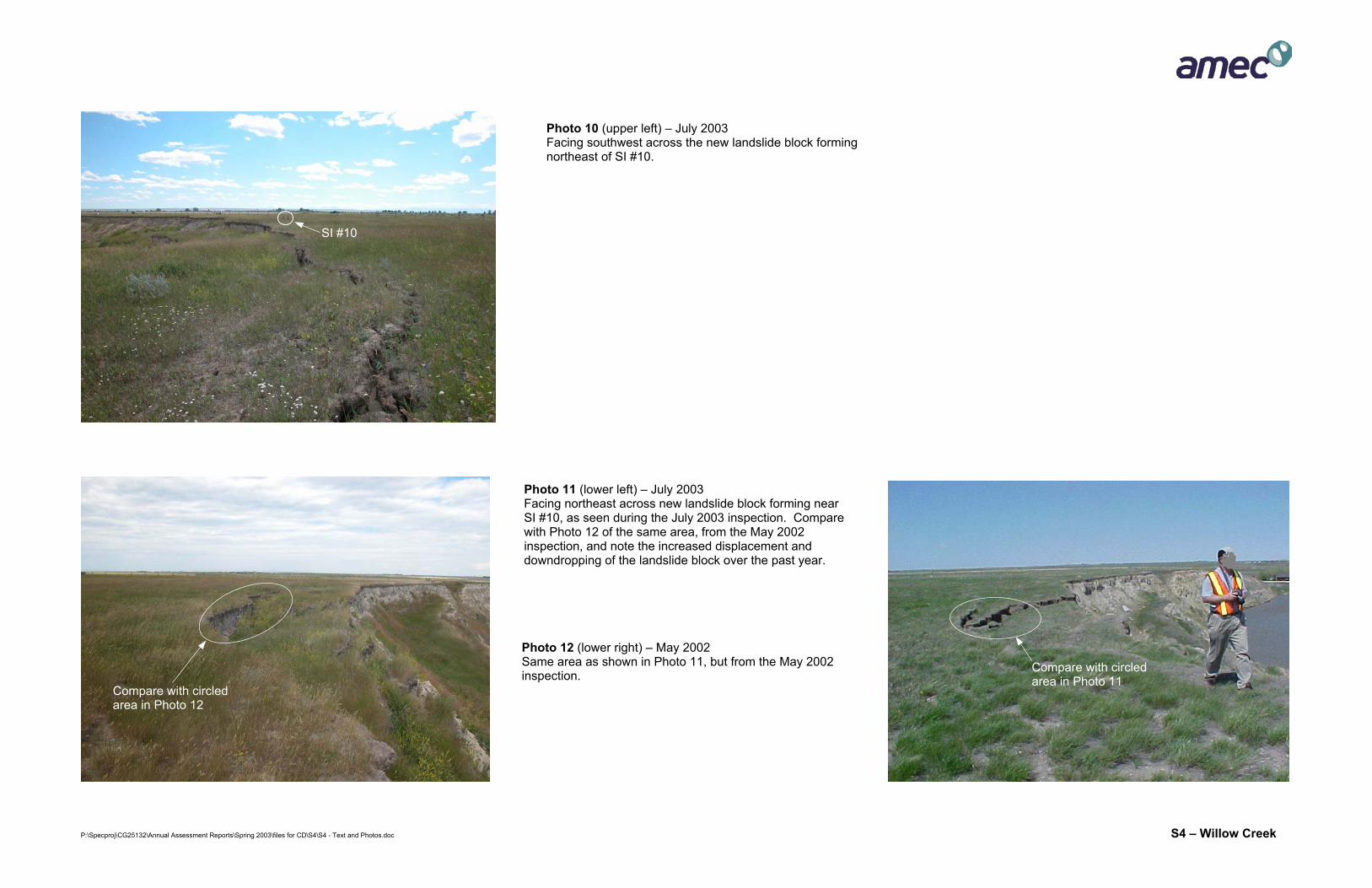
Photo 10 (upper left) – July 2003 Facing southwest across the new landslide block forming northeast of SI #10.
SI #10
Photo 12 (lower right) – May 2002 Same area as shown in Photo 11, but from the May 2002 inspection.
Compare with circled area in Photo 11
Compare with circled area in Photo 12
Photo 11 (lower left) – July 2003 Facing northeast across new landslide block forming near SI #10, as seen during the July 2003 inspection. Compare with Photo 12 of the same area, from the May 2002 inspection, and note the increased displacement and downdropping of the landslide block over the past year.
P:\Specproj\CG25132\Annual Assessment Reports\Spring 2003\files for CD\S4\S4 - Text and Photos.doc S4 – Willow Creek
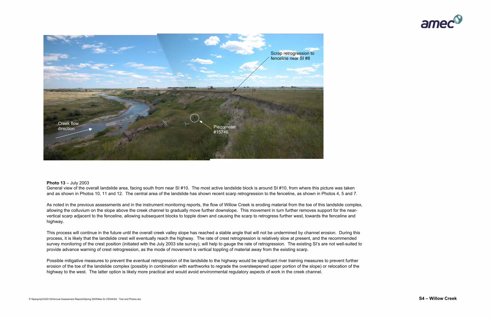
Scrap retrogression to fenceline near SI #8
Creek flow direction Piezometer
#15746
Photo 13 – July 2003 General view of the overall landslide area, facing south from near SI #10. The most active landslide block is around SI #10, from where this picture was taken and as shown in Photos 10, 11 and 12. The central area of the landslide has shown recent scarp retrogression to the fenceline, as shown in Photos 4, 5 and 7. As noted in the previous assessments and in the instrument monitoring reports, the flow of Willow Creek is eroding material from the toe of this landslide complex, allowing the colluvium on the slope above the creek channel to gradually move further downslope. This movement in turn further removes support for the near-vertical scarp adjacent to the fenceline, allowing subsequent blocks to topple down and causing the scarp to retrogress further west, towards the fenceline and highway. This process will continue in the future until the overall creek valley slope has reached a stable angle that will not be undermined by channel erosion. During this process, it is likely that the landslide crest will eventually reach the highway. The rate of crest retrogression is relatively slow at present, and the recommended survey monitoring of the crest position (initiated with the July 2003 site survey), will help to gauge the rate of retrogression. The existing SI’s are not well-suited to provide advance warning of crest retrogression, as the mode of movement is vertical toppling of material away from the existing scarp. Possible mitigative measures to prevent the eventual retrogression of the landslide to the highway would be significant river training measures to prevent further erosion of the toe of the landslide complex (possibly in combination with earthworks to regrade the oversteepened upper portion of the slope) or relocation of the highway to the west. The latter option is likely more practical and would avoid environmental regulatory aspects of work in the creek channel.
P:\Specproj\CG25132\Annual Assessment Reports\Spring 2003\files for CD\S4\S4 - Text and Photos.doc S4 – Willow Creek
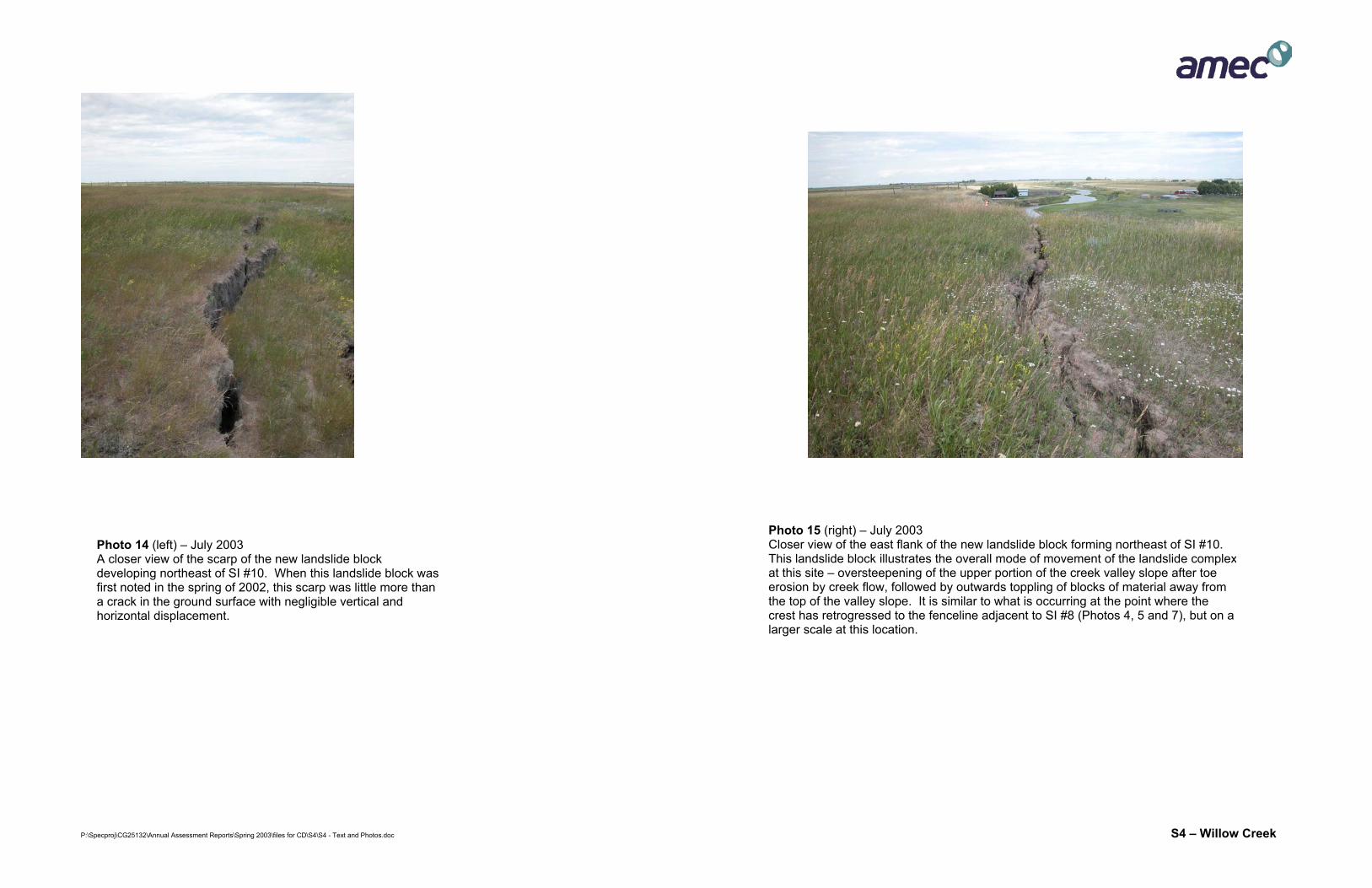
Photo 15 (right) – July 2003 Closer view of the east flank of the new landslide block forming northeast of SI #10. This landslide block illustrates the overall mode of movement of the landslide complexat this site – oversteepening of the upper portion of the creek valley slope after toe erosion by creek flow, followed by outwards toppling of blocks of material away from the top of the valley slope. It is similar to what is occurring at the point where the crest has retrogressed to the fenceline adjacent to SI #8 (Photos 4, 5 and 7), but on a larger scale at this location.
Photo 14 (left) – July 2003 A closer view of the scarp of the new landslide block developing northeast of SI #10. When this landslide block was first noted in the spring of 2002, this scarp was little more than a crack in the ground surface with negligible vertical and horizontal displacement.