Embed Size (px)
Citation preview
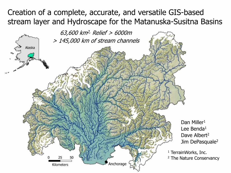
Creation of a complete, accurate, and versatile GIS-based stream layer and Hydroscape for the Matanuska-Susitna Basins
63,600 km2, Relief > 6000m
> 145,000 km of stream channels
Anchorage
Dan Miller1
Lee Benda1
Dave Albert2
Jim DePasquale2
1 TerrainWorks, Inc. 2 The Nature Conservancy

Hydrography “the science that measures and describes the physical features of bodies of water and the land areas adjacent to those bodies of water” NOAA

Hydrography
“the science that measures and describes the physical features of bodies of water and the land areas adjacent to those bodies of water” NOAA
Landscape
“features of an area of land, including the
physical elements of landforms such as mountains, hills,
water bodies such as rivers, lakes, ponds and the sea,
living elements of land cover including indigenous vegetation,
human elements including land use, buildings and structures, and
transitory elements such as lighting and weather conditions”
Wikipedia
Hydrography in a Landscape context: Hydroscape

Digital Hydroscape: Data structures, Computer programs Spatial Template, Interactions, Linkages
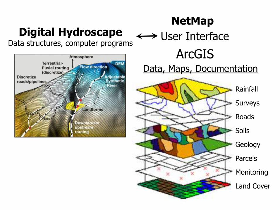
NetMap
Rainfall
Surveys
Roads
Soils
Geology
Parcels
Monitoring
Land Cover
Data, Maps, Documentation
ArcGIS
Digital Hydroscape Data structures, computer programs
User Interface

X
YZ
(i)
(ii)
(v)
(iii)
(iv)
Reach
Nodes - DEM resolution
Digital Elevation Model (DEM)
Flow Routing
Linked flow-path network Synthetic stream layer
Landforms & processes; a landscape context
Attributes: land cover, soils, geology, land use
Connectivity between elements
Components of a digital hydroscape

To build a flow-path network.
1. Contiguous DEM over entire watershed
2. Calibrate channel extent
3. Hydrologic conditioning
4. Build linked channel-node dataset
5. Build GIS output files
6. Verify, fix, repeat Reach
Nodes - DEM resolution
Linked flow-path network Synthetic stream layer

5-m IfSAR
~90m NED
1-m LiDAR
Elevation data sources
1.Warp - to match elevations exactly in areas of overlap
2.Sample to a single, contiguous DEM

You can delete channel segments, but you cannot subsequently add channels.
Calibration – flow-path extent. We want to include all potential channels.

Calibrate channel-network extent. Channel-initiation threshold calibrated to DEM.
Three thresholds:
1) Specific contributing area * slope squared; measure of erosive potential.
2) Plan curvature; measure of flow convergence.
3) Minimum flow length over which above two threshold musts be met.
High
Low
Candidate Initiation Sites
Too short
OK

Enforcement by: • Point (identified channel initiation points) • Line (surveyed channels) • Polygon (water mask)
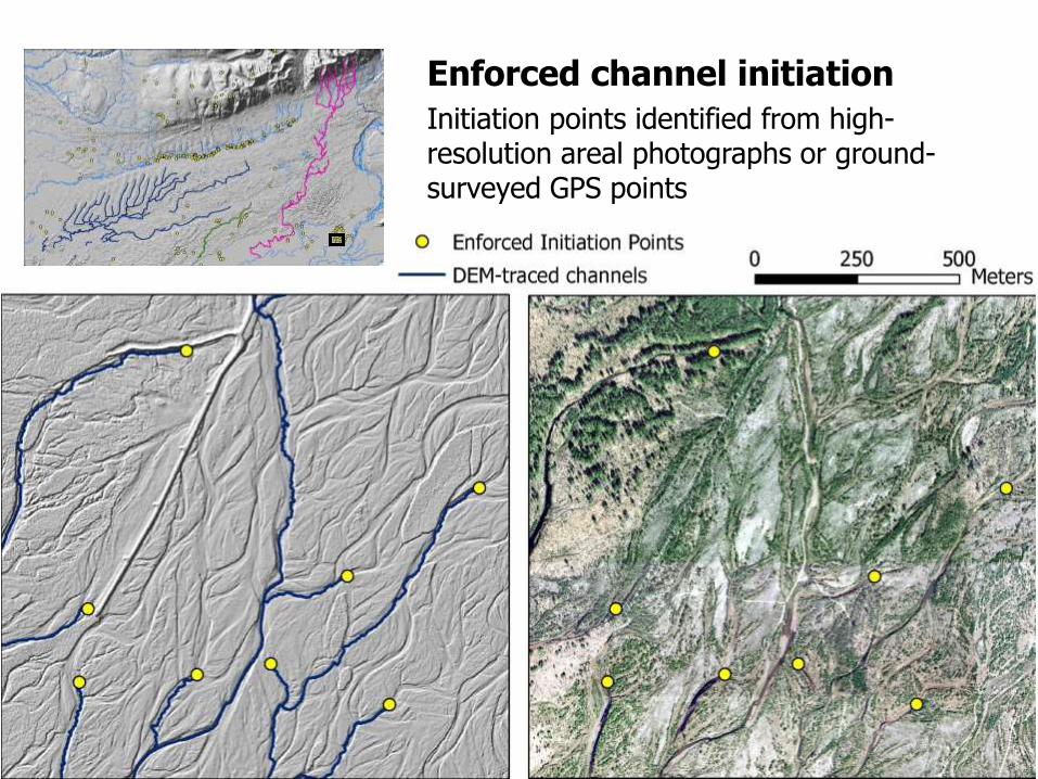
Initiation points identified from high-resolution areal photographs or ground-surveyed GPS points
Enforced channel initiation

Original DEM Excavated swale
1-m deep, 100-m wide
Excavated swale 2-m deep, 100-m wide
Drainage enforcement:
• Encourage flow toward preferred courses
• Degree of encouragement determined by depth and width of excavated swale
• Once flow directions set, swale is removed and all analyses done on original DEM

Water mask: Delineates surface water Derived from remotely sensed imagery
• Hydrologic enforcement – guides flow lines
• Provides channel and habitat attributes
Radar Intensity

NetMap: hydroscape in ArcGIS
Synthetic stream layer
• Attributed
• Validated
• Linked to a variety of models

Agenda
1:30 – 2:00pm, Introduction: What is NetMap? Under the hood: how does NetMap work? How is NetMap used?
2 – 2:30pm Demonstration exercise in the Goose Bay / Big Lake watershed Culverts and Habitat Connectivity
2:30 - 4:00pm Hands-on exercises for the Goose Bay / Big Lake watershed.
Impervious surfaces and water quality
Proximity of parcels to active river flood plain
Parcels near spawning streams
4:00 – 4:30pm Open Discussion
An Introduction to Integrated Hydrography with NetMap Digital Hydroscape
A mapping and analysis platform for stream and watershed assessment
1:30 – 4:30 Thursday, Nov. 20, Alaska Pacific University GIS Lab.

LiDAR reflections don’t see pipes and culverts, so drainage through road prisms and other areas drained by pipes need to be enforced.
Road Crossings


![Augmented Sketch: Faster and More Accurate Stream Processing · surements, web clicks and crawls, massive amounts of data are gen-erated as a high-rate stream [10, 26]. Processing](https://img.pdfslide.us/doc/110x75/5f28daf83c03d06f69515c8d/augmented-sketch-faster-and-more-accurate-stream-surements-web-clicks-and-crawls.jpg)