Embed Size (px)
Citation preview
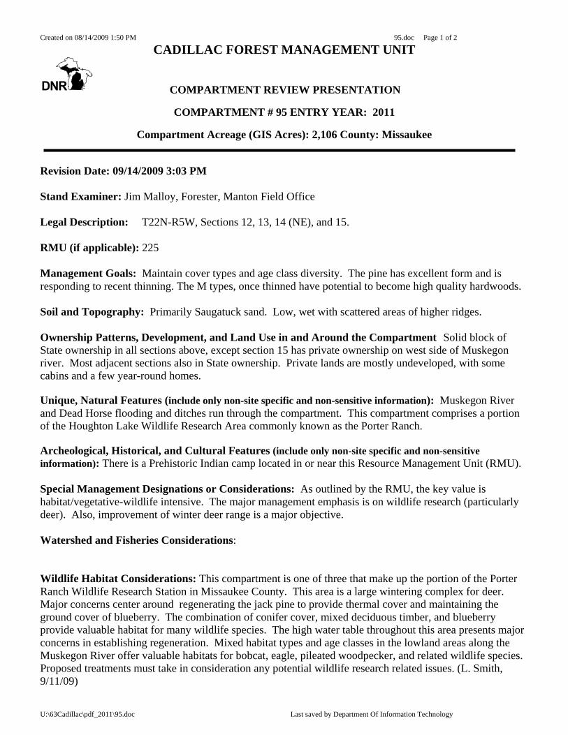
Created on 08/14/2009 1:50 PM 95.doc Page 1 of 2
U:\63Cadillac\pdf_2011\95.doc Last saved by Department Of Information Technology
CADILLAC FOREST MANAGEMENT UNIT
COMPARTMENT REVIEW PRESENTATION
COMPARTMENT # 95 ENTRY YEAR: 2011
Compartment Acreage (GIS Acres): 2,106 County: Missaukee Revision Date: 09/14/2009 3:03 PM Stand Examiner: Jim Malloy, Forester, Manton Field Office Legal Description: T22N-R5W, Sections 12, 13, 14 (NE), and 15. RMU (if applicable): 225 Management Goals: Maintain cover types and age class diversity. The pine has excellent form and is responding to recent thinning. The M types, once thinned have potential to become high quality hardwoods. Soil and Topography: Primarily Saugatuck sand. Low, wet with scattered areas of higher ridges. Ownership Patterns, Development, and Land Use in and Around the Compartment Solid block of State ownership in all sections above, except section 15 has private ownership on west side of Muskegon river. Most adjacent sections also in State ownership. Private lands are mostly undeveloped, with some cabins and a few year-round homes. Unique, Natural Features (include only non-site specific and non-sensitive information): Muskegon River and Dead Horse flooding and ditches run through the compartment. This compartment comprises a portion of the Houghton Lake Wildlife Research Area commonly known as the Porter Ranch. Archeological, Historical, and Cultural Features (include only non-site specific and non-sensitive information): There is a Prehistoric Indian camp located in or near this Resource Management Unit (RMU). Special Management Designations or Considerations: As outlined by the RMU, the key value is habitat/vegetative-wildlife intensive. The major management emphasis is on wildlife research (particularly deer). Also, improvement of winter deer range is a major objective. Watershed and Fisheries Considerations: Wildlife Habitat Considerations: This compartment is one of three that make up the portion of the Porter Ranch Wildlife Research Station in Missaukee County. This area is a large wintering complex for deer. Major concerns center around regenerating the jack pine to provide thermal cover and maintaining the ground cover of blueberry. The combination of conifer cover, mixed deciduous timber, and blueberry provide valuable habitat for many wildlife species. The high water table throughout this area presents major concerns in establishing regeneration. Mixed habitat types and age classes in the lowland areas along the Muskegon River offer valuable habitats for bobcat, eagle, pileated woodpecker, and related wildlife species. Proposed treatments must take in consideration any potential wildlife research related issues. (L. Smith, 9/11/09)
Created on 08/14/2009 1:50 PM 95.doc Page 2 of 2
U:\63Cadillac\pdf_2011\95.doc Last saved by Department Of Information Technology
Mineral Resource and Development Concerns and/or Restrictions:
Sections 12 - 15, T22N-R5W, Missaukee County Surface sediments consist of glacial outwash sand and gravel and postglacial alluvium and peat & muck. The glacial drift thickness varies between 400 and 600 feet. Beneath the glacial drift is the Pennsylvanian Saginaw Formation. The Saginaw is quarried for clay/shale in other parts of the State. Gravel pits are located in the area, and there may be some potential. The compartment is located four miles south of Enterprise Field. This field has produced nearly 5 million BO from the Devonian Richfield Formation and is in secondary recovery operations. The Compartment is not currently leased for oil and gas exploration.. (T. Hone 7/22/09) Vehicle Access: A forest road access plan is detailed on the compartment map. Identified are state and county roads as well as forest roads and trails under the jurisdiction of the DNR. Also indicated are forest roads and trails under the jurisdiction of the DNR that are proposed for abandonment. These roads were determined to be in excess of the access needs in the area, are a threat to the resources, or are a concern environmentally. Proposed new roads or roads recommended for substantial improvement are noted below: Survey Needs: None needed Recreational Facilities and Opportunities: No developed recreation. Hunting, Trapping and wildlife viewing are popular activities in this compartment. A portion of the Houghton Lake snowmobile trail passes through sections 14 & 15. Fire Protection: Much of this compartment has poor access for suppression equipment. Fuels could be support large fire growth. Initial Attack is from the Houghton Lake FO. Additional Compartment Information: There is a County road bridge on Kelly road crossing the Muskegon River. There is a culvert-tube style crossing in place to cross the Dead horse flooding dam with a flood-gateway. The forest road crosses the dam and is then closed and blocked on the east side of the dam to prevent wheeled traffic any further east. There is also a similar bridge crossing in place for Headquarters Rd. 2-track to cross Dead Horse creek in the NW corner of sec. 12. The following parcels are recommended for acquisition if they become available for sale: N/A
The following 5 reports from the Operations Inventory System (OIPC) are attached: ♦ Cover Type by Age Class ♦ Cover Type by Management Objective ♦ Compartment Volume Summary ♦ Proposed Treatments – No Limiting Factors ♦ Proposed Treatments – With Limiting Factors

Created on 08/14/2009 1:50 PM 95.doc Page 3 of 2
U:\63Cadillac\pdf_2011\95.doc Last saved by Department Of Information Technology
The following information is displayed, where pertinent, on the attached compartment maps: ♦ Base feature information, stand numbers, cover types ♦ Proposed treatments ♦ Proposed road access system ♦ Suggested potential old growth
7622-L0
28310-G0
44622-L0
26500-Z0
36622-L0
43623-N0
40500-Z0
52622-L0
46622-L0
48622-L0
51622-L0
24622-L0
14122-X0
38310-G0
21622-L0
23500-Z0
13622-L0
22500-Z0
9622-L0
56117-E5
66117-E9
34319-UM6
26113-E9
204222-J6
334222-J3
454222-J6
164212-J6
494222-J6
474222-J9
314222-J9
564229-MC6
354222-J6
254191-MD6
154130-A5
374222-J6
394222-J6
534221-R5 55
4221-R553
544130-A3
504130-A6
424132-A6
44130-A6
4
274229-MC6
304229-MC9
294222-J3
324311-UM3
344222-J9
106112-P3
124222-J5
176112-P6
186112-P6
114212-J6
181
4131-A3
84133-A3
196119-E9
414222-J6
S Je
ffs R
d
E Kelly Rd
S L
ong
Rd
E Erdman Rd
E Beeler Rd
Nellsvill
e Drain
Nellsville Drain
Muskegon River
84°55’0"W
84°55’0"W
84°54’0"W
84°54’0"W
84°53’0"W
84°53’0"W
84°52’0"W
84°52’0"W
84°51’0"W
84°51’0"W44
°18’
0"N
44°1
8’0"
N
44°1
9’0"
N
44°1
9’0"
N
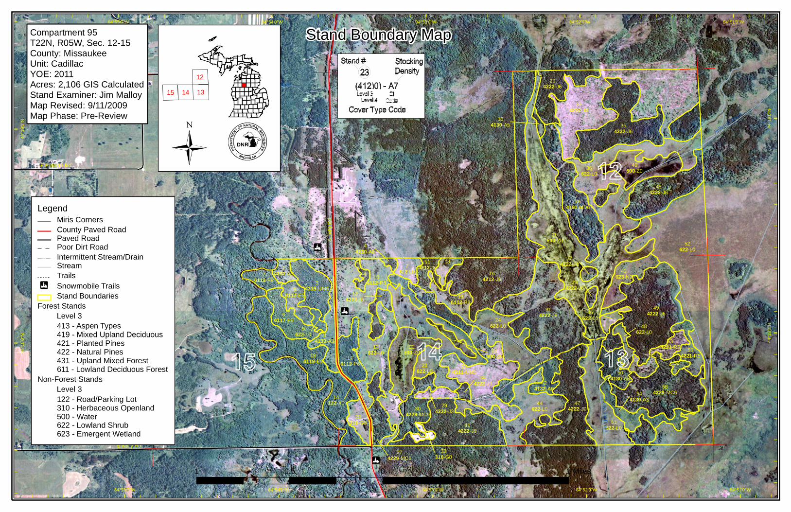
Stand Boundary Map
LegendMiris CornersCounty Paved RoadPaved RoadPoor Dirt RoadIntermittent Stream/DrainStreamTrailsSnowmobile TrailsStand Boundaries
Forest Stands Level 3
413 - Aspen Types419 - Mixed Upland Deciduous421 - Planted Pines422 - Natural Pines431 - Upland Mixed Forest611 - Lowland Deciduous Forest
Non-Forest Stands Level 3
122 - Road/Parking Lot310 - Herbaceous Openland500 - Water622 - Lowland Shrub623 - Emergent Wetland
1 0 10.5 Miles
1315 14
12
Compartment 95T22N, R05W, Sec. 12-15County: MissaukeeUnit: CadillacYOE: 2011Acres: 2,106 GIS CalculatedStand Examiner: Jim MalloyMap Revised: 9/11/2009Map Phase: Pre-Review
7622-L0
28310-G0
44622-L0
26500-Z0
36622-L0
43623-N0
40500-Z0
52622-L0
46622-L0
48622-L0
51622-L0
24622-L0
14122-X0
38310-G0
21622-L0
23500-Z0
13622-L0
22500-Z0
9622-L0
56117-E5
66117-E9
34319-UM6
26113-E9
204222-J6
334222-J3
454222-J6
164212-J6
494222-J6
474222-J9
314222-J9
564229-MC6
354222-J6
254191-MD6
154130-A5
374222-J6
394222-J6
534221-R5 55
4221-R553
544130-A3
504130-A6
424132-A6
44130-A6
4
274229-MC6
304229-MC9
294222-J3
324311-UM3
344222-J9
106112-P3
124222-J5
176112-P6
186112-P6
114212-J6
181
4131-A3
84133-A3
196119-E9
414222-J6
84°55’0"W
84°55’0"W
84°54’0"W
84°54’0"W
84°53’0"W
84°53’0"W
84°52’0"W
84°52’0"W
84°51’0"W
84°51’0"W44
°18’
0"N
44°1
8’0"
N
44°1
9’0"
N
44°1
9’0"
N
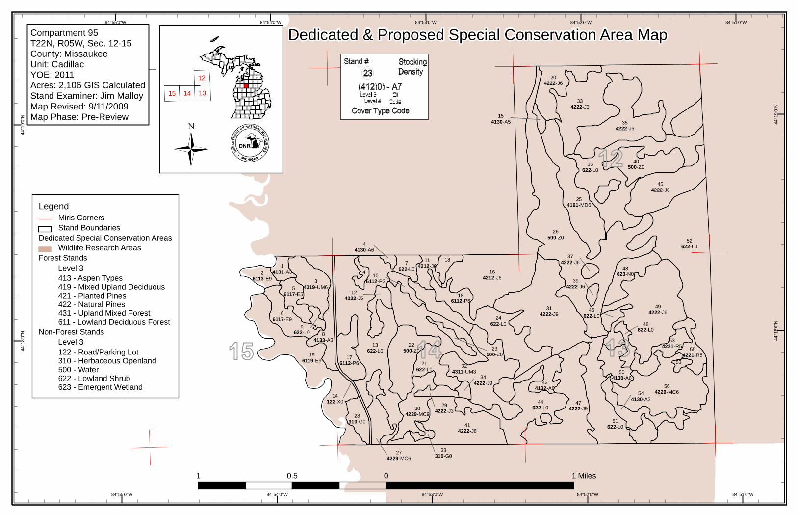
Dedicated & Proposed Special Conservation Area Map
LegendMiris CornersStand Boundaries
Dedicated Special Conservation AreasWildlife Research Areas
Forest Stands Level 3
413 - Aspen Types419 - Mixed Upland Deciduous421 - Planted Pines422 - Natural Pines431 - Upland Mixed Forest611 - Lowland Deciduous Forest
Non-Forest Stands Level 3
122 - Road/Parking Lot310 - Herbaceous Openland500 - Water622 - Lowland Shrub623 - Emergent Wetland
1 0 10.5 Miles
1315 14
12
Compartment 95T22N, R05W, Sec. 12-15County: MissaukeeUnit: CadillacYOE: 2011Acres: 2,106 GIS CalculatedStand Examiner: Jim MalloyMap Revised: 9/11/2009Map Phase: Pre-Review
7622-L0
28310-G0
44622-L0
26500-Z0
36622-L0
43623-N0
40500-Z0
52622-L0
46622-L0
48622-L0
51622-L0
24622-L0
14122-X0
38310-G0
21622-L0
23500-Z0
13622-L0
22500-Z0
9622-L0
56117-E5
66117-E9
34319-UM6
26113-E9
204222-J6
334222-J3
454222-J6
164212-J6
494222-J6
474222-J9
314222-J9
564229-MC6
354222-J6
254191-MD6
154130-A5
374222-J6
394222-J6
534221-R5 55
4221-R553
544130-A3
504130-A6
424132-A6
44130-A6
4
274229-MC6
304229-MC9
294222-J3
324311-UM3
344222-J9
106112-P3
124222-J5
176112-P6
186112-P6
114212-J6
181
4131-A3
84133-A3
196119-E9
414222-J6
Muskegon River
Nellsvill
e Drain
Nellsville Drain
S Je
ffs R
d
E Kelly Rd
S L
ong
Rd
E Erdman Rd
E Beeler Rd
84°55’0"W
84°55’0"W
84°54’0"W
84°54’0"W
84°53’0"W
84°53’0"W
84°52’0"W
84°52’0"W 84°51’0"W44
°18’
0"N
44°1
8’0"
N
44°1
9’0"
N
44°1
9’0"
N
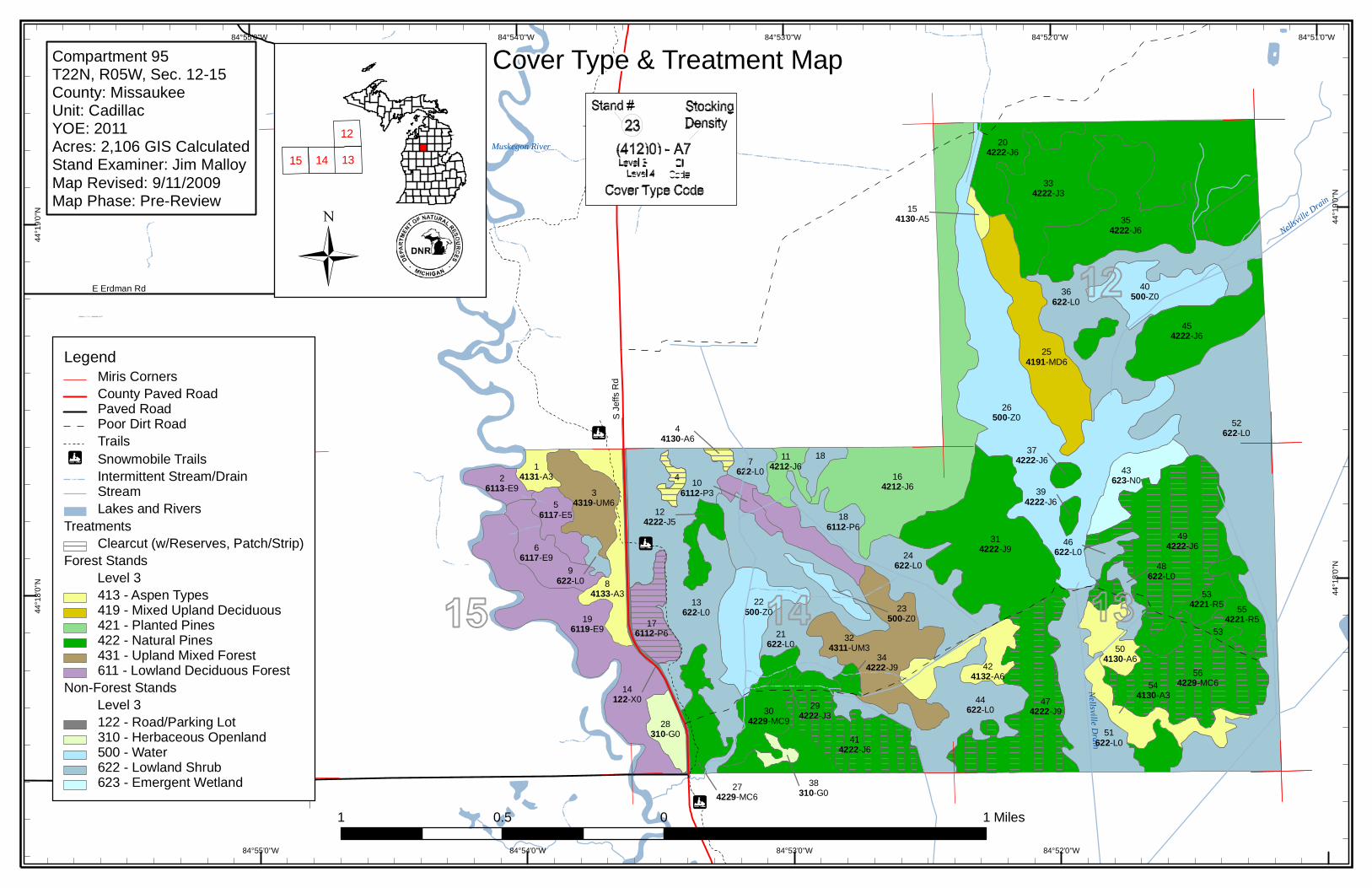
Cover Type & Treatment Map
LegendMiris CornersCounty Paved RoadPaved RoadPoor Dirt RoadTrailsSnowmobile TrailsIntermittent Stream/DrainStreamLakes and Rivers
TreatmentsClearcut (w/Reserves, Patch/Strip)
Forest Stands Level 3
413 - Aspen Types419 - Mixed Upland Deciduous421 - Planted Pines422 - Natural Pines431 - Upland Mixed Forest611 - Lowland Deciduous Forest
Non-Forest Stands Level 3
122 - Road/Parking Lot310 - Herbaceous Openland500 - Water622 - Lowland Shrub623 - Emergent Wetland
1 0 10.5 Miles
1315 14
12
Compartment 95T22N, R05W, Sec. 12-15County: MissaukeeUnit: CadillacYOE: 2011Acres: 2,106 GIS CalculatedStand Examiner: Jim MalloyMap Revised: 9/11/2009Map Phase: Pre-Review
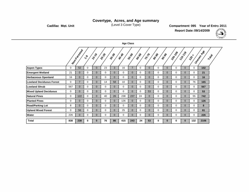
Covertype, Acres, and Age summaryCompartment
Report Date: 09/14/2009
Cadillac Mgt. Unit 095
Non
-For
este
d1-
9
10-1
9
20-2
9
30-3
9
40-4
9
50-5
9
60-6
9
70-7
9
80-8
9
Une
ven
Age
Tota
l
Year of Entry 2011
Age Class
(Level 3 Cover Type)
90-9
9
100-
109
110-
119
120
+
00Aspen Types 520 0 0 23 3 16 7 0 0 0 0 1020
00Emergent Wetland 021 0 0 0 0 0 0 0 0 0 0 210
00Herbaceous Openland 016 0 0 0 0 0 0 0 0 0 0 160
760Lowland Deciduous Forest 70 0 0 14 58 10 0 0 0 0 0 1650
00Lowland Shrub 0567 0 0 0 0 0 0 0 0 0 0 5670
00Mixed Upland Deciduous 00 0 0 0 0 0 0 0 53 0 0 530
550Natural Pines 1220 0 0 40 26 238 237 24 0 0 0 7420
00Planted Pines 00 0 0 0 0 126 0 0 0 0 0 1260
00Road/Parking Lot 08 0 0 0 0 0 0 0 0 0 0 80
00Upland Mixed Forest 560 0 0 0 0 25 0 0 0 0 0 810
00Water 0226 0 0 0 0 0 0 0 0 0 0 2260
0 0 13224238 0Total 838 0 76 86 415 243 53 0 0 2106
2011
TreatmentName
Acres StandAge
Cover TypeObjective
SizeDensity
TreatmentType
TreatmentMethod
Stage1CoverType
Mgt. Unit PROPOSED TREATMENTSNO LIMITING FACTORS
095Compartment: Entry Yr
Stand
Inventory Method: IFMAPCadillac
09/14/2009Date
Page 1 of 2
63095004-Cut 62High Density Pole
AspenHarvest Clearcut with Reserves
6.9
Clearcut aspen and jack pine. leave cherry and white pines. allow aspen to spread into adjacent grass opening.
RevCmnt:
RevSpec
4 4130 - Aspen
NextSteps:
63095017-Cut 48High Density Pole
AspenHarvest Clearcut with Reserves
19.2
Clear-cut. Leave oaks for mast.
RevCmnt:
RevSpec
17 6112 - Lowland Aspen
NextSteps:
63095041-Cut 59High Density Pole
Natural Jack Pine, Mixed Deciduous
Harvest Patch or Strip Clearcut
21.0
Winter cut due to wet conditions.
clearcut strips 2 chains wide throughout stand. No retention within clearcut strips.
RevCmnt:
RevSpec
41 42220 - Natural Jack Pine
NextSteps:
63095047-Cut 66High Density Log Natural Jack Pine, Mixed Deciduous
Harvest Patch or Strip Clearcut
28.0
Winter cut due to wet conditions.
clearcut strips 2 chains wide throughout stand. No retention within clearcut strips.
RevCmnt:
RevSpec
47 42220 - Natural Jack Pine
NextSteps:
63095049-Cut1
62High Density Pole
Natural Jack PineHarvest Patch or Strip Clearcut
47.3
Winter cut due to wet conditions
clearcut strips 2 chains wide throughout stand. No retention within clearcut strips.
RevCmnt:
RevSpec
49 42220 - Natural Jack Pine
NextSteps:
63095056-Cut 52High Density Pole
Natural Jack PineHarvest Patch or Strip Clearcut
33.1
Winter cut due to wet conditions.
clearcut strips 2 chains wide throughout stand. No retention within clearcut strips.
RevCmnt:
RevSpec
56 42290 - Natural Mixed Pine
NextSteps:

2011
TreatmentName
Acres StandAge
Cover TypeObjective
SizeDensity
TreatmentType
TreatmentMethod
Stage1CoverType
Mgt. Unit PROPOSED TREATMENTSNO LIMITING FACTORS
095Compartment: Entry Yr
Stand
Inventory Method: IFMAPCadillac
09/14/2009Date
Page 2 of 2
155.6Total Treatment
Acreage Proposed:

2011
TreatmentName
Acres StandAge
Cover TypeObjective
SizeDensity
TreatmentMethod
Treatment Type
Stage1Cover Type
Mgt. Unit PROPOSED TREATMENTSWITH LIMITING FACTORS
095Compartment: Entry Yr
Stand
Inventory Method: IFMAP
Cadillac
09/14/2009Date
Page 1 of 1
RevCmnt:
RevSpec:
Limiting Factorand Comment:
NextSteps:
No Treatment Reason
0Total Treatment
Acreage Proposed:

SCA Name Acres
Mgt. Unit
PROPOSED SPECIAL CONSERVATION AREA* (SCA) DETAILS
095Compartment:
Stand
Inventory Method: IFMAP
Cadillac
Comments
* This is a partial list of SCAs for this compartment. Not included are those areas identified under other Department initiatIves (Natural Rivers, Deer Wintering Areas, etc.). Those will be identified in separate, future map and report products.
09/14/2009Date:
Page 1 of 1
Type
Mgt. Unit
095Compartment:
Page 1 of 1
Cadillac
Description
09/14/2009Report Date:
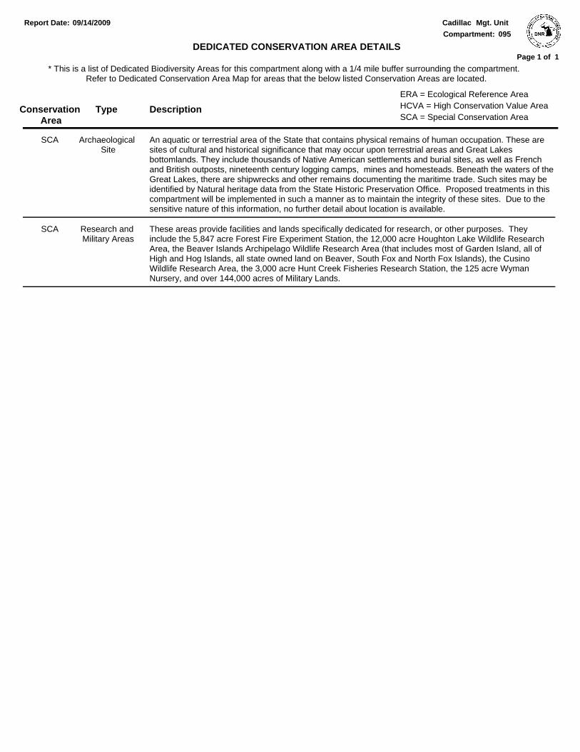
* This is a list of Dedicated Biodiversity Areas for this compartment along with a 1/4 mile buffer surrounding the compartment. Refer to Dedicated Conservation Area Map for areas that the below listed Conservation Areas are located.
DEDICATED CONSERVATION AREA DETAILS
Conservation Area SCA = Special Conservation Area
HCVA = High Conservation Value AreaERA = Ecological Reference Area
An aquatic or terrestrial area of the State that contains physical remains of human occupation. These are sites of cultural and historical significance that may occur upon terrestrial areas and Great Lakes bottomlands. They include thousands of Native American settlements and burial sites, as well as French and British outposts, nineteenth century logging camps, mines and homesteads. Beneath the waters of the Great Lakes, there are shipwrecks and other remains documenting the maritime trade. Such sites may be identified by Natural heritage data from the State Historic Preservation Office. Proposed treatments in this compartment will be implemented in such a manner as to maintain the integrity of these sites. Due to the sensitive nature of this information, no further detail about location is available.
Archaeological Site
SCA
These areas provide facilities and lands specifically dedicated for research, or other purposes. They include the 5,847 acre Forest Fire Experiment Station, the 12,000 acre Houghton Lake Wildlife Research Area, the Beaver Islands Archipelago Wildlife Research Area (that includes most of Garden Island, all of High and Hog Islands, all state owned land on Beaver, South Fox and North Fox Islands), the Cusino Wildlife Research Area, the 3,000 acre Hunt Creek Fisheries Research Station, the 125 acre Wyman Nursery, and over 144,000 acres of Military Lands.
Research and Military Areas
SCA