Embed Size (px)
Citation preview
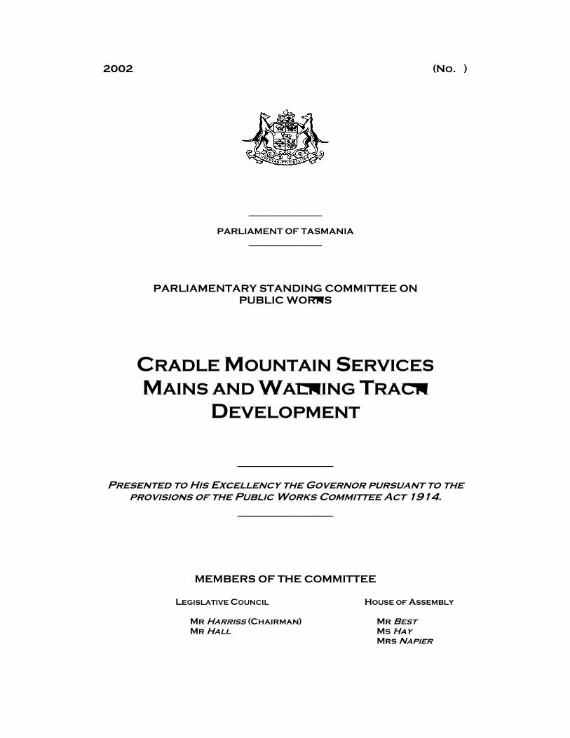
2002 (No. )
_______________
PARLIAMENT OF TASMANIA _______________
PARLIAMENTARY STANDING COMMITTEE ON PUBLIC WORKS
CRADLE MOUNTAIN SERVICES MAINS AND WALKING TRACK
DEVELOPMENT
______________
Presented to His Excellency the Governor pursuant to the provisions of the Public Works Committee Act 1914.
______________
MEMBERS OF THE COMMITTEE
LEGISLATIVE COUNCIL HOUSE OF ASSEMBLY
Mr Harriss (Chairman) Mr Best Mr Hall Ms Hay
Mrs Napier
2
To His Excellency the Honourable Sir Guy Stephen Montague Green, Companion of the Order of Australia, Knight Commander of the Most Excellent Order of the British Empire, Commander of the Royal Victorian Order, Governor in and over the State of Tasmania and its Dependencies in the Commonwealth of Australia.
MAY IT PLEASE YOUR EXCELLENCY The Committee has investigated the following proposal: -
CRADLE MOUNTAIN SERVICES MAINS AND WALKING TRACK DEVELOPMENT
and now has the honour to present the Report to Your Excellency in accordance with the Public Works Committee Act 1914. This reference sought the approval of the Committee for the development of a new walking track between the Cradle Mountain Visitor Centre and Ronny Creek, and the provision of sewage disposal via pumped mains to treatment, power and communications services within the Park. INTRODUCTION Background Cradle Mountain is located in the Cradle Mountain - Lake St Clair National Park and is part of the Tasmanian Wilderness World Heritage Area (WHA). The Park, and Cradle Mountain in particular, enjoys a popular international reputation and is a major tourism destination and one of the places most visited by tourists in the State. The Park caters for a variety of experiences for people, from short informative walks around the Visitor Centre to longer walks around Waldheim and Dove Lake, and the extended walk from Cradle Mountain to Lake St Clair on the Overland Track. Accommodation is available inside and outside the Park. The WHA Management Plan The Tasmanian Wilderness World Heritage Area (WHA) covers some 1.38 million hectares or about 20% of Tasmania. The WHA includes Tasmania’s four largest national parks: The Franklin-Gordon Wild Rivers National Park, the Southwest National Park, the Walls of Jerusalem National Park and Cradle-Mountain Lake St Clair National Park. The area was inscribed on the World Heritage list in 1982 and expanded in size in 1989 in recognition of it's outstanding natural and cultural values. Planning and management of the WHA is directed by the Tasmanian Wilderness World Heritage Area Management Plan 1999 (WHAMP) which is primarily administered by the Tasmanian Parks and Wildlife Service (PWS).
3
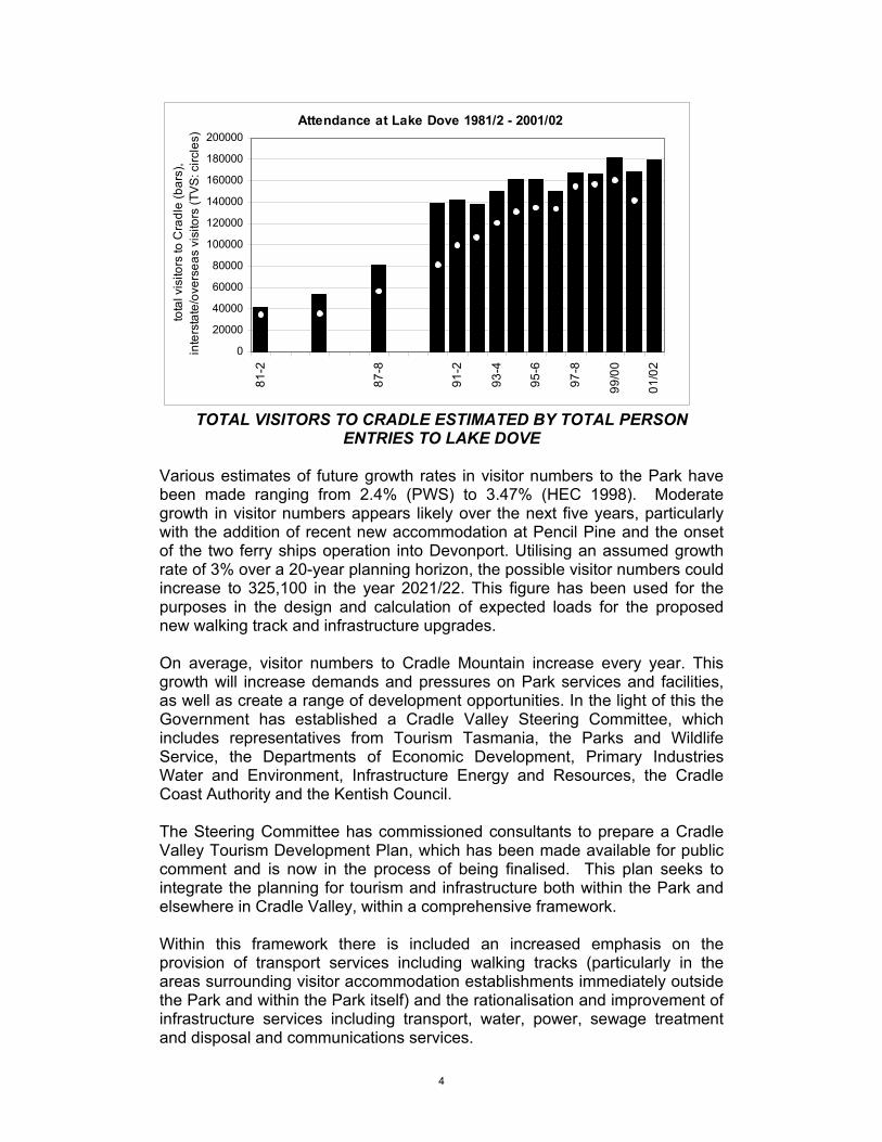
WHAMP defines a number of ‘Visitor Services Zones’ where major facilities for recreation and presentation are to be provided. Cradle Mountain Visitor Access and Information Strategy The Parks and Wildlife Service recognised the limitations of the existing sewage systems and as a result have been considering a range of options for the upgrading of infrastructure services within the Visitor Services Zone since the 1993 VSZ Plan was approved. A Cradle Mountain Visitor Access and Information Strategy (VAIS) was developed in 1999 by a Steering Committee (which included representatives from Tourism, DIER, Kentish Council, the North West District Consultative Committee, Friends of Cradle as well as a number of PWS staff) to address the demand on the Park access and infrastructure services within the Pencil Pine -Cradle Valley Visitor Services Zone. VAIS recommended a staged program for the provision of sewer, mains power and telecommunications to the Waldheim and Dove Lake Precincts of the VSZ. The recommendations in VAIS built on previous studies into the feasibility of under-grounding services and the options and feasibility of linked services within the VSZ, and included the new walking track option. The development priorities outlined in the Strategy specifically included transport, sewage treatment, power and telecommunications and gave rise to the infrastructure project, which is the subject of this reference. In response to these services issues and other infrastructure issues such as roads and transport, an infrastructure redevelopment program has been devised for the VSZ. The primary purpose of the program is to respond to the demand on the Park access and infrastructure services brought about by increasing visitation. The PWS re-established the Committee in early 2001 to progress the funded components of the overall program of works emerging as a consequence of the Strategy, including the services mains project, the new walking track and improvements to vehicle parking provisions. A Project Team was established to manage the combined services mains/walking track project, which is the subject of this reference. Visitation Cradle Mountain is one of the major visitor gateways into the WHA. In 2001/02 the Park received nearly 179,000 visitors. Of this number, the overseas and interstate visitors component represents nearly 30% of all visitors to Tasmania aged 15 years and over (Tourism Tas 2001). Cradle Mountain is also a popular destination for Tasmanians. Visitor survey data from 1999 indicates that roughly 16% of all visitors are from Tasmania. The revised historic series is shown in the figure below. Since 1993, visitor numbers have been increasing by an average of 2.4% per annum.
4
Attendance at Lake Dove 1981/2 - 2001/02
0
20000
40000
60000
80000
100000
120000
140000
160000
180000
200000
81-2
87-8
91-2
93-4
95-6
97-8
99/0
0
01/0
2
tota
l vis
itors
to C
radl
e (b
ars)
, in
ters
tate
/ove
rsea
s vi
sito
rs (T
VS: c
ircle
s)
TOTAL VISITORS TO CRADLE ESTIMATED BY TOTAL PERSON
ENTRIES TO LAKE DOVE Various estimates of future growth rates in visitor numbers to the Park have been made ranging from 2.4% (PWS) to 3.47% (HEC 1998). Moderate growth in visitor numbers appears likely over the next five years, particularly with the addition of recent new accommodation at Pencil Pine and the onset of the two ferry ships operation into Devonport. Utilising an assumed growth rate of 3% over a 20-year planning horizon, the possible visitor numbers could increase to 325,100 in the year 2021/22. This figure has been used for the purposes in the design and calculation of expected loads for the proposed new walking track and infrastructure upgrades. On average, visitor numbers to Cradle Mountain increase every year. This growth will increase demands and pressures on Park services and facilities, as well as create a range of development opportunities. In the light of this the Government has established a Cradle Valley Steering Committee, which includes representatives from Tourism Tasmania, the Parks and Wildlife Service, the Departments of Economic Development, Primary Industries Water and Environment, Infrastructure Energy and Resources, the Cradle Coast Authority and the Kentish Council. The Steering Committee has commissioned consultants to prepare a Cradle Valley Tourism Development Plan, which has been made available for public comment and is now in the process of being finalised. This plan seeks to integrate the planning for tourism and infrastructure both within the Park and elsewhere in Cradle Valley, within a comprehensive framework. Within this framework there is included an increased emphasis on the provision of transport services including walking tracks (particularly in the areas surrounding visitor accommodation establishments immediately outside the Park and within the Park itself) and the rationalisation and improvement of infrastructure services including transport, water, power, sewage treatment and disposal and communications services.
5
Cradle Valley Tourism Development Plan The Cradle Valley Tourism Development Plan states that Cradle Valley should be a place:
o ‘which is identifiable as the entrance to the WHA; o that is a transition between ‘humanised’ landscapes of the
surrounding region and the WHA where natural and cultural values are dominant;
o where the experiences available to visitors are compatible with the values of the WHA;
o where use and resource development reflect and respond to the natural and cultural values of the WHA;
o where use and development is managed to avoid degradation of WHA values;
o which supports the role of Cradle Mountain area as one of Tasmania’s tourist icons; and
o that provides a location for facilities and services to meet the needs of visitors to the WHA.’
The Vision Statement for Cradle Valley, based on a review of the extensive consultation and research carried out in a number of previous studies, is: ‘Cradle Valley is a place with world-class natural and cultural values where quality facilities and experiences are promoted, provided and managed in a sustainable manner.’ The vision can be more explicitly expressed as a set of objectives:
o ‘to identify and protect the natural and cultural values of the area. o to manage activities (recreation, tourism, education) to protect the
natural and cultural values of the area. o to promote and provide quality visitor experiences which reflect and
respond to the natural and cultural values of the area. o to develop the capacity to undertake the management of activities
necessary to achieve the above objectives. o to support the existing tourism investment within Cradle Valley and
provide opportunities for sustainable new development.’ Project Objectives The overall requirement is for a redevelopment that is sympathetic to the natural and heritage values of the area, and also resolves a number of issues that detract from these values relating to the arrangement of existing services infrastructure. In particular, the redevelopment is required to comply with the overall Planning provisions detailed in the Pencil Pine – Cradle Valley Visitor Services Zone Plan 1993 as amended. Generally, the objectives are:
□ To minimise further disturbance of the natural environment by making optimal use of existing facilities and structures and areas
6
already disturbed, and by the removal of redundant facilities and the restoration of some previously disturbed areas.
□ To maintain visitor services and safe visitor access throughout the development in a manner which continues to provide the quality of experience expected in a World Heritage Area.
□ Maintain the natural setting and cultural integrity of the Park and particular sites.
□ Protect the Park's visual and natural values through all stages, including construction and future operation.
□ Design solutions to be suited to the climatic conditions of the Valley. Provide protection for natural ecosystems including native vegetation and wildlife.
□ Employ adequate and appropriate measures to ensure that weeds and diseases (e.g. Phytophthora) are not carried into the Park by construction staff and vehicles or through imported construction material.
□ Ensure the safety of Park staff and maintenance contractors, in particular the safe and convenient access from car parks and roads to plant servicing points.
For the services mains, the particular objectives are:
□ To redevelop the Park’s power, sewerage and communication
services infrastructure in a manner that minimises the overall environmental, visual and social impacts as far as possible whilst using effective environmental design solutions with proven technology to minimise operational costs.
□ To ensure the design of the services mains is integrated with the walking track, the road works and other Program components to ensure the best possible outcomes in relation to both construction and long-term operation and maintenance.
□ Plant should be incorporated with other facilities and services in the one building envelope as far as possible.
□ Connection of services (power, water, sewage and telecommunications) to facilities, particularly shelters, to be provided for in a manner that provides ease of access for servicing with least disruption to vegetation and visitors.
For the walking track, the particular objectives are to:
□ Provide a safe walking trail from the Park entrance at Pencil Pine
to Dove Lake and Waldheim, and associated day walk areas (currently the only walking access option is along the narrow road alignment).
□ Provide a new stand-alone scenic and interpretive walking trail, which traverses a range of spectacular landforms and vegetation types thus enhancing the visitor experience.
□ Provide additional scope for guided interpretive walking tours within the Cradle Valley Visitor Services Zone.
7
□ Provide an extension to the Overland Track for walkers wishing to commence or finish their walking experience at the Park boundary (Pencil Pine).
□ Provide an integral link to the proposed integrated transport system.
□ Provide an environmentally sound route and appropriate infrastructure in which to install essential services i.e. power, sewerage mains and telecommunication cabling between the Visitor Centre, Ronny Creek and Waldheim.
EVIDENCE The Committee commenced its inquiry on Monday, 2 December 2002. The submission of the Department of Tourism Parks Heritage and the Arts was received and taken into evidence. The following witnesses appeared, made the Statutory Declaration and were examined by the Committee in public:-
o Peter Williams, General Manager, Parks & Wildlife Service; o Jane Foley, Tourism Tasmania o Bob Tyson, Manager Tourism Infrastructure Parks and Wildlife
Service; o Allen Carman-Brown, District Planner North West; o Hank Schinkel, Senior Ranger Cradle Mt; o Trevor Westren, Technical Officer o Brian Giles, Hydro Tasmania; o Roy Cordiner, Consultant Project Manager; o Jim Spinks, President, Friends of Cradle; o Richard Burns, Secretary, Friends of Cradle.
THE NEED FOR THE DEVELOPMENT Existing Infrastructure Services The existing infrastructure services within the Park are entirely inadequate to meet existing requirements let alone respond to future growth in demand, which is considered to be inevitable. The current arrangements have been arrived at over a number of years through an ad-hoc process responding to very limited funding and rapidly increasing visitor demand. The services have now reached a stage where the continued impact on, and degradation of, the environment is considered to be unacceptable if World Heritage Area status is to be maintained. In particular, the effluent disposal systems are posing potential health risks and environmental damage to native vegetation and pristine waterways through long-term seepage. The sewerage systems at Dove Lake, Waldheim and Waldheim Junction utilise stand-alone low quality treatment systems, which do not meet current
8
DPIWE Emission Limit Guidelines applicable to Inland Waters Accepted Modern Technology treatment methods. The systems do not comply with the requirements of the Tasmanian Health Act and the Tasmanian Plumbing Code. Communications services for visitors are non-existent, which poses risks for visitors, particularly after hours and in inclement weather, and difficulties for Park management staff in times of emergency. The rudimentary power supply systems that serve the accommodation for visitors at Waldheim and the staff accommodation at Waldheim Junction are high maintenance and have a negative impact on environmental values. The issues are the burning of wood, diesel fuel and gas; the potential risk of fire due to wood burning; the potential risk of the spillage of fuels during storage or transportation; noise pollution from the generator; and ongoing maintenance and servicing costs associated with separate infrastructure systems being used within the Park. Increased visitation to the VSZ in the future is likely to exacerbate all of these problems. Pedestrian Access within the Park Whilst the area around the Visitor Centre and Dove Lake is particularly well served with walking tracks that provide great amenity for visitors, the connection between the Visitor Centre and the track network within the Park is only accessible by road The road is certainly not ‘pedestrian friendly’ and has not been designed as such, even in it’s proposed upgraded and sealed form. Thus the concept of a walking track to overcome these problems, and provide a new visitor experience is considered to be essential. The fact that the track will additionally provide a lower impact, lower cost alternative for the carriage of the services mains is an added benefit. THE PROJECT PLANNING BACKGROUND Infrastructure Services Planning The Hydro Electric Corporation (HEC) conducted a feasibility study in 1998 for the Parks and Wildlife Service (PWS) that reviewed the existing infrastructure at Dove Lake, Waldheim and the Ranger accommodation at Waldheim Junction within the Visitor Services Zone at Cradle Mountain. The service capacities that are required to meet the future projected visitor numbers for the electricity, sewerage and communications services were established and a number of infrastructure development options for the delivery of these services were investigated. The options included:
o Linked mains for all services.
9
o Retaining and upgrading the existing systems. o Storage and disposal of sewage using pump trucks. o Stand-alone arrangements involving both on-site sewage
treatment and solid waste disposal. o Linked underground services with stand-alone power.
As the outcome of this study the HEC recommended that the linked services mains option be pursued and that the services be placed underground in a common trench within the proposed new road alignment between Dove Lake and the Cradle Mountain Visitor Centre. The cost of the preferred option was estimated to be $1.88 million. The Parks and Wildlife Service invited the HEC to provide a supplementary report on the option of construction at night. In doing this the HEC identified two further options to night-time construction in October 1999:
o Widening the existing road by 2 metres. o A new walking track route.
Costs were identified which suggested that night-time construction at $2.22 million was the cheapest option but the HEC concluded that further options analysis should be supported by more detailed site investigation and environmental analysis because of the sensitivity of the area. No recommendation was made as to a preferred option. Following this study concerns were expressed about the feasibility of installing underground services within the road alignment and the Departments of Infrastructure Energy and Resources and Primary Industries, Water and Environment jointly commissioned Gutteridge Haskins and Davey (GHD) in June 2000 to undertake a further study in relation to this. Three options were identified:
o Undertaking the installation work while still maintaining one lane vehicle access along the Cradle Valley road.
o Undertaking the works while maintaining pedestrian access along the Cradle Valley road.
o Undertaking the work at night with the road closed. Of these three options, the report concluded that closing the road and working at night was the only realistic option but also raised further environmental and social issues that would need to be addressed if this option was pursued. These included:
o The impact on adjacent vegetation in particular the roots of large trees as a result of excavating the trench to lay the services.
o The potential damage by the excavator to overhanging limbs along the construction corridor.
o Devaluation of the environmental experience for park visitors due to construction noise.
o Disruption to visitor’s holiday schedules due to delays associated with construction works.
10
The cost identified by GHD for this option was $4.1 million for night-time construction. Government funding support was obtained for the project and Hydro Tasmania were commissioned in May 2001 to undertake a detailed review and analysis of the three feasible options with a view to establishing the procurement path for the project. These options were identified as being:
1. Stand-alone services, with provision for storage of sewage, and trucking out to a treatment plant at the Park boundary.
2. Construction of a trench along the side of the Cradle Mountain – Dove Lake Road and the installation of the three services underground to the vicinity of the Visitors Centre.
3. Installation of the services within the board walk structure of a proposed new walking track between the Visitors Centre and Waldheim Junction; and with the installation of the three services underground within the alignment of the Waldheim road and the Dove Lake road from Waldheim Junction.
The work undertaken by Hydro Tasmania included detailed site investigations and preliminary design studies and it concluded in a report dated August 2001 that the services incorporating sewerage, communication and mains electricity supply should be installed within the proposed new walking track structure. Further detailed analysis in support of the Environmental Impact Assessment carried out by consultants Inspiring Place during the design development phase of this project also provided Hydro Tasmania with the opportunity to undertake a further review of the original options for the installation of infrastructure services. The design development phase of the project was reported on in June 2002 and clearly supported the original recommendation to install the services along the walking track route between the Visitors Centre and Ronny Creek. In current cost terms, the comparison is:
Option
Capital Cost
NPV Annual Recurrent
Costs Real
Discount Rate 8 %,
25 yrs
Total Cost in Present
Value Terms
Option 1 – Stand Alone Services - Store and Truck Out
$1,470,990 $977,596 $2,448,586
Option 2 – Road Route - Daylight $3,294,775 $181,254 $3,476,029 Option 2 – Road Route - Night $3,013,543 $181,254 $3,194,797 Option 3 – Walking Track Route - Mains
$2,414,991 $181,254 $2,138,727
Option 3 – Walking Track Route - Track
$1,256,209 $40,999 $2,138,727
Option 3 – Total $3,671,200 $222,253 $3,893,453
11
If Option 2 were to be pursued the disturbance to visitors would be the highest of all the options during the construction period and the impact on (and indirect cost to) the tourism industry and the environment would be substantial and unacceptable. Whilst the above estimates have factored in the direct construction risks, the other risks cannot be costed. Option 1 would involve ongoing and increased disturbance to visitors and unacceptable impacts on and risks to the environment due to the requirement to generate power within the Park and truck out sewage. For Option 3, the effective nett whole of life cost of providing the walking track varies between $700,000 and $420,000 (depending on the road option above) and the benefits in providing the new walking track are considerable, particularly at this low cost. The recommended option was endorsed by the PWS based on the conclusions that it:
□ Offered the highest possible standard of service provision and the opportunity to cater for future expansion of visitor facilities in the park if they are required.
□ Had the potential for environmental disturbance to the park to be minimised during construction activity.
□ Had the least impact on visitors during construction. □ Had the least risk involved in the implementation and future
operation of the system. □ Provided the most efficient, workable and cost efficient
maintenance regime for Aurora and the PWS in the long term. □ Facilitated the development of the new walking track, offering a
new visitor experience within the Park, which minimised risks for walkers sharing the roadway with vehicles.
Walking Track Planning Route Selection The selection of the proposed route is the result of:
□ initial site investigations by PWS Cradle Mountain staff and the identification of a preliminary route;
□ review of the preliminary route by Hydro Tasmania to consider requirements for safe and feasible installation of the services;
□ field review of the preliminary route by specialists from the Nature Conservation Branch (DPIWE) to identify sites where there were potential impacts on natural values;
□ further field investigations (involving Cradle Mountain PWS, Hydro Tasmania, PWS specialists and Inspiring Place Pty Ltd) to identify alternative route options for portions of the walking track to further avoid or minimise impacts on natural and cultural values and to reduce risk management concerns; and
□ GPS mapping of the final proposed walking track route.
12
As a consequence of the above investigations, the proposed route has been located such that it:
□ provides experiences of a variety of natural features by locating the walking track away from Cradle Mountain Road, where possible, and to minimise visual impact of the walking track from the road.
□ largely avoids disturbance to vegetation with known conservation values e.g. grasslands communities, areas of sphagnum bog, pencil pine (individuals and clusters) and beech (myrtle);
□ eliminates the risk to the Aboriginal shelter in the vicinity of Quailes Hill;
□ eliminates safety risks for users of the existing Dove Canyon track who presently return to the Visitor Centre via Cradle Mountain Road;
□ minimises the need for vegetation clearance; □ minimises potential impacts on the Ptunarra brown butterfly, a
species listed as endangered species by Threatened Species Protection Act 1995, by avoiding their preferred grassland habitat;
□ avoids changes to drainage patterns along the walking track route; □ minimises physical severance of wildlife grazing habitats; □ limits the need for major site works and rehabilitation by avoiding
the option of trenching the service mains and cables underground; □ minimises steep gradients thus limiting the requirement for using
steps on the walking track; □ minimises risks associated with trees and limbs falling across the
walking track; □ minimises the number of crossings over the Dove River or other
watercourses, which might require bridging; □ minimises tight turns in the track that pose difficulties for the
installation or operation of the service cables and pipes. Route Description The route is 5.75 km long from its start at the Visitor Centre to its terminus at the existing Ronny Creek Car Park, which is also the start of the Overland Track. Over its length, the proposed route passes at times through rainforest, open eucalypt forest and button grass, bridging the Dove River twice. Elsewhere watercourses are crossed using the normal construction arrangement of the walking track. Over its length, the route rises approximately 70m in altitude, an average gradient of ~1.2% or 1 in 82. However, the slope varies from this average along the route, with relatively steep pinches on the climb up and over the saddle at the rear of Quailes Hill and the climb up and over Snake Hill. The proposed alignment has been designed to avoid areas of steep gradient. Where steep gradients cannot be avoided (e.g. Snake Hill), stairs will be required. In other less steep but nonetheless sloping ground, a combination of steps and landings (on inclines/declines up to 17% or 1m in 5.8m
13
maximum) or ramps (on inclines/declines not to exceed 12% or 1m in 8.3m maximum) will be used. At the final stages near Waldheim Junction, the proposed route closely follows the Dove River. In this area, the track will be elevated above the exposed bedrock because of the steepness of the terrain and to also minimise disturbance to bedrock features. Alternative routes through this area were rejected because of their likely impact on Sphagnum bog and grassland vegetation communities. This first kilometre of the track replaces a portion of the existing Dove Canyon Track. In doing so, it serves to link the Dove Canyon Track directly to the Visitor Centre, taking walkers off Cradle Mountain Road. The rerouting of this portion of the Dove Canyon Track also serves to reduce potential impacts on known Aboriginal sites in the Quailes Hill area, which are located in close proximity to the existing Dove Canyon Track. Along the proposed route, one access track will be constructed at Snake Hill. The access track at Snake Hill follows the route of a previously used track at that location. During construction, the access track will be used to move material and equipment into the development site. Following construction, the track will become a link track, which will enable visitors to leave the main track and access a bus stop on Cradle Mountain Road. The track alignment will continue around to the existing Ronny Creek car park, which is the start of the Overland Track. From this point at Ronny Creek, the services mains will be placed under the road alignment, as part of the proposed road upgrading, until their terminus point at Dove Lake. It should be noted that the design of the walking track structure and the services enables minor refinement of the track alignment in the field, enabling features of local significance to be skirted if required (e.g. habitat trees, wet areas). THE DESIGN RESPONSE Design of the Walking Track The walking track and its components have been designed to meet the standards required for a Class 2 walking track as defined by Australian Standard 2156.1-2001 (Walking Tracks Part 1: Classification and Signage). The deck will have a width of 1000mm over a 700mm wide structure built using treated pine timbers and galvanised fixings. The structural design of the track has been designed in accordance with the Australian Standard 1170-SAA Loading Code and AS 2156.2 -2001 Walking Track – Infrastructure Design.
14
The track is supported on timber posts nominally spaced at 3 m centres and driven into the soil using a hand or machine piling system. The services tray is carried on timber bearers attached to the posts and located below the track. The timber decking will be covered with galvanised chicken wire to provide a non-slip surface. Bridge structures will be of galvanised steel construction, suitably painted or coated to reduce visual impacts with timber decking and handrails above. Handrails on the bridges will be of Type A construction as defined by AS 2156.2:2001 Walking Track – Infrastructure Design (the most stringent of the defined handrail types e.g. prevents a child under six from mounting the barrier). Bridge decking will also be designed to AS 2156.2:2001 requirements. The elevated walkway adjacent to the Dove River will be of timber construction with posts anchored to bedrock using chemical setting bolts. Handrails on the elevated walkway portion of the track will be of Type A construction as defined by AS 2156.2:2001 Walking Track – Infrastructure Design (the most stringent of the defined types). The economic life of the timber structure has been rated at a minimum of 25 years using CCA treated timbers and galvanised fixtures. At the end of the 25-year period an assessment will need to be made regarding the future economic life of the structures. They could be selectively replaced with no major impact. In relation to the visual impacts it is expected that most visitors would consider the viewing of walkers on the track as being something of visual interest rather than an impact and siting of boardwalk to take advantage of screening from existing vegetation cover and rehabilitation of selected roadside vegetation areas is a further intention during the construction phase. There is an opportunity to establish rest and relaxation areas at points of interest along the track, with interpretation of the surrounding natural environment thus providing further variation to the user’s experience. Design of the Services Mains General Arrangement In general, all of the services are to be housed within a galvanised steel protective tray suspended under the proposed walking track. Where the services enter or exit the walking track (as at the Visitor Centre and at Waldheim Junction), the services will be located in trenches (Hydro Tasmania Drawing TD 422-001) (nominally 1100mm in depth but encased within a steel pipe where the trench depth is less than 750mm). In any case, the protective tray will not be visible to users of the walking track. Accidental contact with the services will not be possible and intentional access difficult because of the encasement of the services within the protective steel
15
tray under the boardwalk. Encasement in the protective steel tray will also prevent wildlife accessing the services. In all cases, the economic life of the various mains is estimated to be 30 years. Electrical System The proposed electrical service mains are intended to provide power to facilities within the Visitor Services Zone including accommodation at Waldheim, Staff Accommodation at Waldheim Junction, interpretive and day use facilities at Waldheim, future park transport shelters, the existing toilets at Dove Lake and the proposed sewerage system. The key design components of the proposed electrical system are:
o upgrading of the existing sub-station at Cradle Mountain Lodge; o extension of the existing 22 kV electrical cable from the Visitors
Centre to Waldheim Junction with the cable located under the proposed timber walking track in a galvanised metal rack; and
o installation of a 22kV distribution pad (located adjacent the walking track) and a 415V distribution board located within the existing generator shed at Waldheim Junction.
The 22kV system (the minimum size equipment to meet current demand) accommodates not only existing loads but also current projected electrical loads, with a potential for a capacity for a further 50% loading for future expansion if required. On completion it will be operated and maintained by Aurora Energy. The proposed system is likely to produce an Electromagnetic Field (EMF) strength of 0.68 milligauss (mG) at a 5Amp load current and 1.35mG at a 10Amp load current. The British Government’s National Radiological Protection Board indicates that these levels are well below the recommended limits and well within the levels considered normal even within household electrical appliances. Suspension of the electrical cable beneath the boardwalk deviates from AS/NZS 3000:2000 and has required a special dispensation from the Chief Electrical Inspector, Electricity Standards and Safety, Department of Infrastructure, Energy and Resources which has been received. In consideration of safety issues involved in departing from standard practice of burying high voltage cables in outdoor locations, the following provisions have been made in the design:
o a circuit breaker at the Cradle Mountain Lodge end of the system;
o the cable will be fitted with sensitive earth fault leakage protection;
o enclosure of the cabling in a galvanised steel protective tray fitted with a screwed lid (the tray will be strengthened where there is a potential risk of significant trees or limbs falling onto
16
the track and the tray replaced by steel pipe at bridge crossings and at entry and exit points where burial is less than 750mm);
o labeling of the lid sections with DANGER HIGH VOLTAGE CABLE and signage at the commencement points to the track SERVICES INSTALLED WITHIN; and
o the walking track will be used by pedestrians only, with vehicle access strictly prohibited.
It is also intended that PWS staff will receive special training in safe work practices for track repair in the vicinity of high voltage cabling. Aurora Energy will be responsible for the high voltage equipment. Establishment of the new electrical mains will enable removal of the existing power generator at Waldheim Junction, thereby eliminating potential environmental impacts from spillage of fuel or lubricants, from the burning of fossil fuels and/or increased risk of fire. Sewerage System The proposed sewage services are intended to link all of the visitor services nodes within the VSZ to the existing P and O sewage treatment plant at Pencil Pine outside the park. The sewage system has been designed to meet a capacity of roughly 400,000 visitors per annum which is the estimated visitation expected by 2025 assuming a mid-range growth scenario of 3% per annum on current visitor numbers. A 40600-litre sewage retention tank will be installed under the existing car park next to the lower of the Staff houses at Waldheim Junction. This tank will store sewage received from the Waldheim area and from Dove Lake (where there will be smaller storage tanks as well) in transit to the Visitor Centre and on to the sewage treatment plant at Pencil Pine. The storage tanks at Dove Lake, Waldheim and Waldheim Junction will be fitted with both duty and standby ‘macerators’ (grinder pumps), which break solids into pieces for easier transport as an initial stage in the treatment process. All of the storage tanks provide a 24-hour retention capability at each location in the event of an emergency. Sewage will be pumped through the system via a Class 12 (the highest commercially available class of pipe), 63mm OD poly pipe from Dove Lake through to the Visitor Centre. Pulse pumping will be used in early morning hours and during periods of low ambient temperature to ensure that sewage does not freeze in the pipe system. Nonetheless, the proposed poly pipe has sufficient inherent strength/flexibility to withstand freezing and thawing in the event that pulse pumping should fail. The entire system is automated and alarmed, with cut off switches triggered in the event of a power failure by a differential flow sensor located at the Visitor Centre.
17
Amongst other things, the establishment of the sewerage system will enable the removal of the existing septic systems at Waldheim Junction and Dove Lake thus eliminating the environmental impacts, which are presently occurring at these locations. Communications System The proposed communications system has been developed to provide a communications backbone with a minimal number of connections initially but with the capability for expansion. The proposed system is composed of a 12-core fibre optic cable installed within the same protective galvanised steel tray as the sewerage pipe. The key outcomes of the proposed new system are that it:
o allows full control and monitoring of the sewerage and electrical systems;
o establishes PWS management and public telephone facilities throughout the VSZ, enabling emergency calls from all of the visitor nodes;
o enables removal of existing communication antennae at Waldheim Junction thereby eliminating a visual impact; and
o provides the ability for improved communications (including a secure and separate link to the Meteorology Bureau weather station at Waldheim Junction), interpretation (e.g. using a PC terminal, video display, digital camera, automated weather station and other capacity) and security/traffic management (enables video cameras to be remotely operated if required).
o Plus other management services which may become available during the 30-year life expectancy.
Post Construction Operation and Management Upon completion of the project, the entire high voltage electrical installation will become part of the Aurora Energy state electrical infrastructure and will be owned, operated and maintained by Aurora as an extension of the supply system in area. A contracted maintenance management, repair and inspection program will be developed for the sewerage system, low voltage power and communications systems. A maintenance and inspection program for the walking track structure and other services will be formalised by PWS. The Australian Standard for the class of the track requires that the inspection interval be 90 days or less. Parks and Wildlife Staff will receive training relative to maintenance of the walkway in light of the associated high voltage cable hazards. Specific procedures for the management of trees and vegetation and the replacement of walkway sections will be developed.
18
VALUE MANAGEMENT AND RISK MANAGEMENT The project has been subject to value management processes from its inception to ensure that the project fundamentals are soundly based and that the best value for money is achieved as one of the principal outcomes. Construction value management principles will also be used for the procurement phase of the Project. This means that if the audited cost of all the packages is less than the budget then the savings will be shared between the PWS, Hydro Tasmania and the package contractors (including day labour staff) on a pre-determined basis. Risk analysis has been undertaken and a Risk Management Plan will be developed and updated before the project proceeds into the construction phase. An Occupational Health and Safety Plan will also be developed and implemented. The Friends of Cradle made the following submission in relation to the proposal: “Friends have unanimously endorsed the construction of infrastructure separate from the Cradle Mountain Road for the following reasons 1. Our group has recognised for some years the urgency for having the
Cradle Mountain Road surface sealed. The earlier idea of installing services under the road would add extra years’ delay to getting this necessary work completed.
2. Separating the two projects means that it will be possible for each project to proceed immediately.
3. Laying the service lines on the surface would be less disruptive to the delicate environment than digging trenches, whether that be under the road or away from the road. We understand that there are stringent requirements regarding depth and surrounding material when services are to be buried. Removing spoil and bringing in special gravel would pose great hazards for the local vegetation. The bedrock in the valley is quartzite, an extremely hard and rock with few natural cracks or joints. It can be seen regularly exposed at the surface along the Dove River valley. Such outcrops were found to be a problem in the minor road works that followed the 2001 bus accident. If the buried services proposal were to proceed, encountering quartzite outcrops would result in further delays and expense.
4. Adequate provision has been made in the plans for access for maintenance and servicing once the mains and track are installed.
Concerning the walking track 5. On most days, especially during peak season, walkers are found
walking along the road between Dove Lake and the Park entrance. The sealing of the surface will eliminate the unpleasantness of road dust, but road walking will continue to be an unsafe exercise. We would expect the risk to actually increase since there is no doubt that the speed of cars breaking the law will increase.
19
6. The Friends of Cradle Valley have always believed that entering the Park and making your way to Cradle Mountain is an integral part of the experience of this unique place. Hence our advocacy of a narrow winding road for drivers. Walkers approaching Cradle Mountain need to be isolated from vehicle noise and exhaust. A separate walking track will enhance their experience.
Concerning the sewerage line 7. A regular item of discussion at Friends’ meetings since our inception
has been the unpleasant smell at Waldheim and Dove Lake due to the ineffective sewage treatment. The rangers and PWS have tried to increase the effectiveness of the process, but the low average temperature negates any attempted improvements. Piping the sewage out to where there is more space for a full treatment process seems the only option.
8. Overloading of those effluent treatment systems at present in the Valley could contaminate Dove River and Ronny Creek.
9. Currently no toilet facilities exist at Ronny Creek, one of the major starting points for walks. An early start on this project will eliminate this health hazard.
Concerning power and communications line 10. Bringing power in to Cradle Valley, particularly the Waldheim precinct,
will allow the Service to get rid of the noisy generator, and to install better interpretive displays in Waldheim Chalet, the Trailside Museum, the day hut and Mt Kate House. One major problem hindering the mounting of displays is that these buildings are too damp.
11. Some Friends regard a phone line as essential, some are unsure of its necessity.
The Friends of Cradle Valley are pleased that we have been invited to participate in the design process and know that our major concerns have been addressed. We endorse the development as stated in the submission made to this committee by the Department of Tourism Parks Heritage and the Arts, with the following extra comments regarding the walking track.
• Walkers’ entrance to the Cradle Valley has to be a pleasurable and wonderful experience. Being made aware regularly that they are walking over a sewerage pipe will not add to that experience. We have been assured that the running of the effluent through the pipe will be soundless. Some venting of the effluent is necessary. We have asked that these vents be led away from the track before rising, hidden by vegetation.
• Over 5km of track with the same surface will be boring, and from several Friends’ experience could lead to inattention and accidents. At a few stages during the design process, we have asked that some variation be introduced. This could be done without too much extra cost by using a different pattern of
20
boards on corners or introducing a different colour during the treatment of the pine timber, and laying this on corners.
• We ask that the effect of the box frame on the movement of small animals be monitored.”
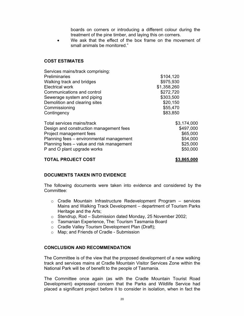
COST ESTIMATES Services mains/track comprising: Preliminaries $104,120 Walking track and bridges $975,930 Electrical work $1,358,260 Communications and control $272,720 Sewerage system and piping $303,500 Demolition and clearing sites $20,150 Commissioning $55,470 Contingency $83,850 Total services mains/track $3,174,000 Design and construction management fees $497,000 Project management fees $65,000 Planning fees – environmental management $54,000 Planning fees – value and risk management $25,000 P and O plant upgrade works $50,000 TOTAL PROJECT COST $3,865,000 DOCUMENTS TAKEN INTO EVIDENCE The following documents were taken into evidence and considered by the Committee:
o Cradle Mountain Infrastructure Redevelopment Program – services Mains and Walking Track Development – department of Tourism Parks Heritage and the Arts;
o Stendrup, Rod – Submission dated Monday, 25 November 2002; o Tasmanian Experience, The: Tourism Tasmania Board o Cradle Valley Tourism Development Plan (Draft); o Map; and Friends of Cradle - Submission
CONCLUSION AND RECOMMENDATION The Committee is of the view that the proposed development of a new walking track and services mains at Cradle Mountain Visitor Services Zone within the National Park will be of benefit to the people of Tasmania. The Committee once again (as with the Cradle Mountain Tourist Road Development) expressed concern that the Parks and Wildlife Service had placed a significant project before it to consider in isolation, when in fact the
21
strategic plan for the whole area in terms of development, had yet to be completed. The development will provide an improved visitor experience at one of the highly visited tourist destinations in the State, whilst addressing the critical environment issues related to the existing services infrastructure.
Accordingly, the Committee recommends the project, in accordance with the plans and specifications submitted, at an estimated total cost of $3,865,000.” Parliament House HOBART 3 January 2003
Hon. A. P. Harriss M.L.C.CHAIRMAN