Embed Size (px)
Citation preview

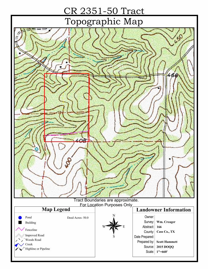
Owner:Survey:
Abstract:County:
Date Prepared:Prepared by:
Source:Scale:
Landowner InformationMap LegendN
EW
S
2015 DOQQScott Hammett
Cass Co., TX166Wm. CreagerBuilding
Improved RoadWoods RoadCreekHighline or Pipeline
Pond Deed Acres- 50.0
CR 2351-50 Tract
%#
CR 2351Cooper Road
CR 23
50
1"=660'
Tract Boundaries are approximate.For Location Purposes Only
Fenceline

© 1997 DeLorme. Street Atlas USA © 1997 DeLorme. Street Atlas USA © 1997 DeLorme. Street Atlas USA © 1997 DeLorme. Street Atlas USA © 1997 DeLorme. Street Atlas USA
77
77
77 77 77 77
MariettaMariettaMariettaMariettaMariettaCusseta
BethlehemBethlehemBethlehemBethlehemBethlehemBethlehemBethlehemBethlehemBethlehemBethlehemBethlehemBethlehemBethlehemBethlehemBethlehemBethlehemBethlehem
NickleberryNickleberryNickleberryNickleberryNickleberryNickleberryNickleberryNickleberryNickleberryNickleberryNickleberryNickleberryNickleberryNickleberryNickleberryNickleberryNickleberry
COUNTY RD 2359
CR 2348CR 2348
CR 2352
CR 2352
CR
2353
CR 2354
CR
2355
CR
2356
CR 2359
CR
236
0
CR
236
1C
R 2
578
CR
2589
CR 2590
CR 2590
591
CR 2591
C
CR
259
2
CR
259
6
CR 2
619
CR
262
1
CR
2621
CR 2622
2727
E MAINFRONTP
INE
VENS
WOMMACK
F-M 1399
F-M 1399
F-M
250
F-M 250
CR 2
345
CR 2345
CR 2348CR 2348
CR
2349
CR 2349
CR
235
0
CR 2351C
R 2
354
CR 2362
CR 2363
CR 2469 CR 2
CR
247
0
CR 2578
F-M
994
F-M
994
Elliot Creek
Floyd C
reek
ch
Holly Branch
Bear
Cre
ek
Bear Creek
Bear Creek
Brown Cre
Flat
Cre
ek
Flat Cree
k
Kings B
ranc
h
For Location Purposes OnlyNot to Scale
© 1997 DeLorme. Street Atlas USA © 1997 DeLorme. Street Atlas USA © 1997 DeLorme. Street Atlas USA © 1997 DeLorme. Street Atlas USA © 1997 DeLorme. Street Atlas USA
Elliot Creek
Floyd C
reek
ch
Holly Branch
Bear
Cre
ek
Bear Creek
Bear Creek
COUNTY RD 2359
CR 2348CR 2348
CR 2352
CR 2352
CR
2353
CR 2354
CR
2355
CR
2356
CR 2359
CR
236
0
CR
236
1C
R 2
578
CR
2589
CR 2590
CR 2590
591
CR 2591
C
CR
259
2
CR
259
6
CR 2
619
CR
262
1
CR
2621
CR 2622
2727
E MAINFRONTP
INE
VENS
WOMMACK
F-M 1399
F-M 1399
F-M
250
F-M 250
77
77
77
Brown Cre
Flat
Cre
ek
Flat Cree
k
Kings B
ranc
h
CR 2
345
CR 2345
CR 2348CR 2348
CR
2349
CR 2349
CR
235
0
CR 2351C
R 2
354
CR 2362
CR 2363
CR 2469 CR 2
CR
247
0
CR 2578
F-M
994
F-M
994
77 77 77
BethlehemBethlehemBethlehemBethlehemBethlehemBethlehemBethlehemBethlehemBethlehemBethlehemBethlehemBethlehemBethlehemBethlehemBethlehemBethlehemBethlehem
NickleberryNickleberryNickleberryNickleberryNickleberryNickleberryNickleberryNickleberryNickleberryNickleberryNickleberryNickleberryNickleberryNickleberryNickleberryNickleberryNickleberry
MariettaMariettaMariettaMariettaMarietta
Cusseta
For Location Purposes OnlyNot to Scale
Mag 14.00Fri Aug 05 09:00 2016Scale 1:37,500 (at center)
2000 Feet
1000 Meters
Local Road
Major Connector
State Route
Utility/Pipe
Small Town
Summit
Locale
Cemetery
Woodland
River/Canal
Intermittent River
CR 2351-50 Tract Location MapCR 2351-50 Tract Location MapCR 2351-50 Tract Location MapCR 2351-50 Tract Location MapCR 2351-50 Tract Location Map
Owner:Survey:
Abstract:County:
Date Prepared:Prepared by:
Source:Scale:
Landowner InformationMap LegendN
EW
S
2015 DOQQScott Hammett
Cass Co., TX166Wm. CreagerBuilding
Improved RoadWoods RoadCreekHighline or Pipeline
Pond Deed Acres- 50.0
CR 2351-50 TractTopographic Map
%#
CR 2351Cooper Road
CR 23
50
1"=660'
Tract Boundaries are approximate.For Location Purposes Only
Fenceline

Owner:Survey:
Abstract:County:
Date Prepared:Prepared by:
Source:Scale:
Landowner InformationMap LegendN
EW
S
2015 DOQQScott Hammett
Cass Co., TX166Wm. CreagerBuilding
Improved RoadWoods RoadCreekHighline or Pipeline
Pond
CR 2351-50 TractSoils Map
%#
CR 2351Cooper Road
CR 23
50
CtE
KiC SlCKiC
CtE
KiC BoC
1"=660'
Tract Boundaries are approximate.For Location Purposes Only
FencelineSoilmu_a_tx616.shp
BoCCtEKiCSlC

CR 2351-50Legal Description