Embed Size (px)
Citation preview

COUNTY OF NEVADA
NOTICE OF INTENT TO ADOPT AN
INITIAL STUDY/MITIGATED NEGATIVE DECLARATION
Project Name: Soda Springs Bridge Over South Yuba River Replacement Project
Bridge Number 17C-0010
NOTICE IS HEREBY GIVEN that the County of Nevada, as a lead agency, is circulating for public
review a Draft Initial Study/Mitigated Negative Declaration (IS/MND) in accordance with the California
Environmental Quality Act (CEQA) for the proposed Soda Springs Bridge Over South Yuba River
Replacement Project. The analysis within the Draft MND/IS finds that all potential environmental effects
are less than significant or can be mitigated to less than significant levels by incorporation of mitigation
measures.
Project Location: Soda Springs Road Bridge over South Yuba River, 750 feet south of the intersection
of Donner Pass Road and Soda Springs Road, within the community of Soda Springs, approximately 6
miles from the town of Truckee, California (see attached map).
Project Description: The Nevada County Department of Public Works, in cooperation with the California
Department of Transportation (Caltrans), is proposing to replace the two-lane Soda Springs Road Bridge
(Bridge #17C-0010) over the South Yuba River with a two-lane concrete slab bridge in the
unincorporated community of Soda Springs in Nevada County, California. As this bridge serves a rural
part of Nevada County, the annual average daily traffic (AADT) is less than 1,000 vehicles per day. The
proposed bridge will replace the existing structure with a single-span, approximately 44-foot long by 40-
foot wide, cast-in-place reinforced concrete slab bridge. The bridge will accommodate two 12-foot lanes,
two 3-foot shoulders, a 6-foot sidewalk, and bridge railings at each edge of deck. The bridge will be
supported by two spread footing abutments.
Public Review: Dokken Engineering has prepared a draft IS/MND for the Nevada County Department of
Public Works for the project identified above to assess the potential project impacts to the environment
and community. The draft IS/MND is being circulated for a 30-day public review period, from June 16,
2017 to July 17, 2017. Comments must be received by 5 p.m. on the last day of the comment
period, July 17, 2017. The IS/MND prepared for this project and the documents used in
preparation of the IS/MND can be reviewed at the Nevada County Public Works Department, 950
Maidu Ave., Nevada City, CA or online at http://dokkenbridges.com/nevada-county/. Nevada County
is inviting comments on the adequacy of the IS/MND. Interested parties may submit their comments to
Joshua H. Pack, Principal Civil Engineer, at [email protected], or at Nevada County Public
Works, 950 Maidu Avenue, Suite 170, Nevada City, CA 95959.
Final IS/MND: Following close of the public comment period, responses to comments received on the
Draft IS/MND will be prepared and together with any corresponding revisions to the Draft IS/MND will
constitute a Final MND. The Board of Supervisors will hold a public hearing before it considers adoption
of the IS/MND. A public hearing date has not yet been calendared for this project.


SODA SPRINGS BRIDGE OVER SOUTH YUBA RIVER
REPLACEMENT PROJECT
Nevada County
Bridge No. 17C-0010
BRLO-5917(079)
INITIAL STUDY WITH
PROPOSED MITIGATED NEGATIVE DECLARATION
Prepared by Dokken Engineering for the:
Nevada County Department of Public Works
June 2017


MITIGATED NEGATIVE DECLARATION
Project Name: Soda Springs Bridge Over South Yuba River Replacement Project
Bridge Number 17C-0010
This Document Is Considered Draft Until It Is Adopted By The Board Of Supervisors
In accordance with the California Environmental Quality Act (CEQA), the County of Nevada
has prepared an Initial Study to determine whether the following project may have a significant
adverse effect on the environment. This Mitigated Negative Declaration is comprised of this
form along with the Initial Study and Mitigation Monitoring and Reporting Program.
I. Project Location: Soda Springs Road Bridge over South Yuba River, 750 feet south of the
intersection of Donner Pass Road and Soda Springs Road, within the community of Soda
Springs, approximately 6 miles from the town of Truckee, California
II. Project Description: The Nevada County Department of Public Works, in cooperation with
the California Department of Transportation (Caltrans), is proposing to replace the two-lane
Soda Springs Road Bridge (Bridge #17C-0010) over the South Yuba River with a two-lane
concrete slab bridge in the unincorporated community of Soda Springs in Nevada County,
California. As this bridge serves a rural part of Nevada County, the annual average daily traffic
(AADT) is less than 1,000 vehicles per day. The proposed bridge will replace the existing
structure with a single-span, approximately 44-foot long by 40-foot wide, cast-in-place
reinforced concrete slab bridge. The bridge will accommodate two 12-foot lanes, two 3-foot
shoulders, a 6-foot sidewalk, and bridge railings at each edge of deck. The bridge will be
supported by two spread footing abutments.
III. Proposed CEQA Findings: That the Board of Supervisors has received and considered the
proposed Initial Study/Mitigated Negative Declaration attached hereto together with all
comments received during the public review process; that, based on the entire record before the
Board, there is no substantial evidence that the proposed project might have any significant
adverse impact on the environment; that the proposed Mitigated Negative Declaration reflects
the independent judgment of the Board of Supervisors; that the location and custodian of the
documents which constitute the record of these proceedings is the Nevada County Department of
Public Works, 950 Maidu Avenue, Nevada City, California.
IV. Mitigation Measures Included in the Initial Study to Avoid Potentially Significant Effects:
Refer to the attached Initial Study and Mitigation Monitoring and Reporting Program for
mitigation measures to avoid the following impacts: air quality, biological resources, cultural
resources, hazards and hazardous waste, hydrology and water quality, and noise.
Sean Powers
Community Development Agency Director
Trisha Tillotson
Director of Public Works
Sean Powers
Community Development Agency Director
Trisha Tillotson
Director of Public Works
COUNTY OF NEVADA
COMMUNITY DEVELOPMENT AGENCY DEPARTMENT OF PUBLIC WORKS 950 MAIDU AVENUE, NEVADA CITY, CA 95959 -8617 (530) 265-1411 FAX (530) 265 -9849 www.mynevadacounty .co m


Soda Springs Road over South Yuba River Replacement Project 1 of 63
June 2017
NEVADA COUNTY, CALIFORNIA INITIAL STUDY with
MITIGATED NEGATIVE DECLARATION
Date: June 2017
Prepared by: Dokken Engineering
110 Blue Ravine Road, Suite 200
Folsom, CA 95630
Reviewed by: Joshua Pack, Principal Civil Engineer
Nevada County Department of Public Works
950 Maidu Avenue
Nevada City, CA 95959
(530) 265-7059
Email: [email protected]
Project Location: Soda Springs Road Bridge over South Yuba River Replacement Project
is located approximately 750 feet south of the intersection of Donner
Pass Road and Soda Springs Road, within the community of Soda
Springs, and approximately 6 miles from the town of Truckee,
California.
Project Description
The Nevada County Department of Public Works, in cooperation with the California Department of
Transportation (Caltrans), is proposing to replace the two lane Soda Springs Road Bridge (Bridge # 17C-
0010) over the South Yuba River with a two lane concrete slab bridge in Nevada County, California
(Figure 1. Project Vicinity and Figure 2. Project Location). As this bridge serves a rural part of Nevada
County, the annual average daily traffic (AADT) is less than 1,000 vehicles per day.
The Soda Springs Road Bridge, constructed in 1965, spans the South Yuba River in a northeast-southwest
direction with the river flowing in a southeast-northwest direction. Soda Springs Road has two travel
lanes (approximately 12 feet wide). The existing bridge is a two-span continuous steel multi-girder
superstructure with a reinforced concrete deck. The spans are 15 feet long and the total bridge length is
approximately 32 feet long.
Caltrans maintenance inspection records show that the bridge is structurally deficient due to its deck
condition. In response, Nevada County Department of Public Works proposes to replace the bridge and
secure a combination of local and Highway Bridge Program funds for preliminary engineering,
environmental, right of way acquisition, construction, and construction engineering. The Project Area is
approximately 3.18 acres, which will encompass all project activities including potential staging areas,
temporary bridge construction, and bridge removal and replacement processes.
Purpose/Need
The purpose of the Soda Springs Road Bridge over the South Yuba River Replacement Project is to
replace a structurally deficient bridge by replacing the bridge with a structure that can withstand modern
traffic loading demands, that meets modern safety standards, and that accommodates river flows as the
existing bridge does not meet hydraulic requirements.

I0 10 20
Miles
Source: ESRI 2008; Dokken Engineering1/13/2017; Created By: llawson
_̂
Project Location
P L U M A S
P L A C E R
E L D O R A D O
B U T T E
S I E R R A
N E V A D A
Y U B A
W A S H O E
L A S S E N
A L P I N E
S A C R A M E N T O
D O U G L A S
SUTT
ERT E H A M A
A M A D O R
C A R S O N C I T Y
YOLO
§̈¦80
§̈¦80
£¤395
£¤50
£¤50
£¤50
£¤395
£¤395
£¤50
£¤395
£¤50
UV49
UV88
UV70
UV89
UV193
UV20
UV99
UV206
UV431
UV162
UV207
UV174
UV267
UV4
UV147
UV428
UV16UV99
UV89
UV49
UV89
UV89
UV89
UV70
UV49
UV89
UV20
UV70
UV70
UV70
UV89
Plumas National Forest
Eldorado National Forest
Toiyabe National Forest
Lassen National Forest
Stanislaus National Forest
Marshall Gold Discovery State Historic Park
Lake Oroville State Rec AreaLake Oroville State Rec Area
Auburn State Recreation AreaAuburn State Recreation Area
Lake Tahoe Nevada State ParkLake Tahoe Nevada State Park
Malakoff Diggings St Hist ParkMalakoff Diggings St Hist Park
Folsom Lake State Rec AreaFolsom Lake State Rec Area
DL Bliss State ParkDL Bliss State Park
Malakoff Diggins St Hist ParkMalakoff Diggins St Hist Park
Sugar Pine Point State ParkSugar Pine Point State Park
Lumsden ParkLumsden Park
Emerald Bay State ParkEmerald Bay State Park
Donner Memorial State ParkDonner Memorial State Park
Washoe Meadows State ParkWashoe Meadows State Park
Empire Mine State Hist ParkEmpire Mine State Hist ParkCondon ParkCondon Park
Gold Bug ParkGold Bug Park
Pioneer ParkPioneer Park
Old Sacramento State Historic ParkOld Sacramento State Historic Park
Kings Beach State Recreation AreaKings Beach State Recreation Area
Tahoe State Recreation AreaTahoe State Recreation Area
Delleker ParkDelleker Park
V:\21
01-S
oda_
Sprin
gs_R
d_BR
\F1_V
icinity
-2015
-01-07
.mxd
FIGURE 1Project Vicinity
Soda Springs Road over South Yuba River Bridge Replacement ProjectNevada County, California
PACIFIC OCEAN
NevadaCounty

I0 0.25 0.5
Miles
Source: USA Topo Map; Dokken Engineering1/13/2017; Created By: llawson
Lincoln Hwy
Lincoln Hwy
Soda Springs Rd
Project Location
Donner Pass Rd§̈¦80
V:\21
01-S
oda_
Sprin
gs_R
d_BR
\F2_L
ocati
on-20
15-1-
09mx
d.mxd
FIGURE 2Project Location
Soda Springs Road over South Yuba River Bridge Replacement ProjectNevada County, California

Soda Springs Road over South Yuba River Replacement Project 4 of 63
June 2017
The bridge is needed to replace the existing structure that has been determined to be structurally deficient
due to the condition of the existing deck. In addition to the deck deficiencies, the bridge replacement is
needed to increase the hydraulic capacity of the bridge and improve the functionality and safety of the
existing bridge crossing.
Surrounding Land Uses
The bridge serves various residential properties in Nevada County, including the Serene Lakes
subdivision, and provides access to the Soda Springs ski resort and a portion of the Tahoe National
Forest. The area surrounding the project is primarily “REC” recreation, as designated in the Nevada
County General Plan (Nevada County 2014a). Recreation lands are intended to provide for a wide range
of recreation uses and supporting services (e.g. ski resorts).
Replacement Alternative
The proposed bridge widening will replace the existing structure with a single span, approximately 44-
foot long by 40-foot wide, cast-in-place reinforced concrete slab bridge (Figure 3. Project Features). The
bridge will accommodate two 12-foot lanes, two 3-foot shoulders, a 6-foot sidewalk, and bridge railings
at each edge of deck. The bridge will be supported by two spread footing abutments.
The roadway will be maintained at two travel lanes. At least one lane of Soda Springs Road will remain
open during construction, as this road is the only all-weather access to the Serene Lakes residential
community. A temporary detour constructed on temporary embankment across the river just upstream of
the bridge is anticipated to accommodate traffic during bridge construction.
All roadway and structure improvements are anticipated to fall within existing right-of-way. It is
anticipated that the Project will require temporary easements to be acquired for the proposed bridge
replacement.
Project Background
The Soda Springs Road Bridge was constructed in 1965. The existing bridge is a two-span continuous
steel multi-girder superstructure with a reinforced concrete deck that requires continuous maintenance to
manage the delamination of the deck slab. During the winter months, the South Yuba River commonly
overtops the bridge, and heavy snowfall is known to block vehicle access. The bridge is the only all
season access to the residential community south of the Soda Springs Road Bridge, and is typically used
for a high level of bicycle access during the summer months.
Caltrans maintenance inspection records show that the bridge is structurally deficient due to its deck
condition. In response, Nevada County Department of Public Works proposes to replace the bridge and
secure a combination of local and Highway Bridge Program funds for preliminary engineering,
environmental, right of way acquisition, construction, and construction engineering.
Related Projects
The Van Norden Dam Modification Project, currently proposed by Truckee Donner Land Trust (TDLT),
would notch the Van Norden Lake dam level approximately 5 feet. In October 2015, TDLT opened the
22-inch culvert below the dam, in part to reduce the potential for dam failure and flooding of downstream
uses in anticipation of the 2015/16 El Nino winter season. The valve remains open as of this writing, and
this condition was in place during the technical studies prepared for and design of the current Soda
Springs Road Bridge project. Increased flows from the Van Norden Dam Modification Project have been
considered throughout the project planning process, technical studies, and design of the Soda Spring Road
Bridge replacement.

I0 150 300
Feet
Source: USA Topo Map; Dokken Engineering1/26/2017; Created By: angelas
Soda Springs Rd
V:\21
01-S
oda_
Sprin
gs_R
d_BR
\Biolo
gy\F3
_Proj
ect F
eatur
es_w
ithin
BSA_
2016
-1230
.mxd
FIGURE 3Project Features Within the BSA
Soda Springs Road at South Yuba River Bridge Replacement ProjectNevada County, California
Potential ESA FencingBiological Study Area (8.1 acres)Project Area (3.1 acres)
Project FeaturesEdge of PavementTemporary RoadwayCut and Fill LimitsRockSlopeProtection

Soda Springs Road over South Yuba River Replacement Project 6 of 63
June 2017
Other Permits Which May Be Necessary
The following permits may be required from the designated agencies:
1. NPDES General Construction Permit – Central Valley Regional Water Quality Control Board
2. Section 401 Water Quality Certificate – Central Valley Regional Water Quality Control Board
3. Section 404 Permit – US Army Corps of Engineers
4. Section 1602 Streambed Alteration Agreement – California Department of Fish and Wildlife
5. Dust control and operations permits - Northern Sierra Air Quality Management District
Environmental Factors Potentially Affected
All of the following environmental factors have been considered. Those environmental factors checked
below would be potentially affected by this project, involving at least one impact that is "Less Than
Significant with Mitigation" as indicated by the checklist on the following pages.
1. Aesthetics
2. Agriculture / Forestry
Resources
3. Air Quality
4. Biological Resources
5. Cultural Resources
6. Geology / Soils
7. Greenhouse Gas
Emissions
8. Hazards / Hazardous
Materials
9. Hydrology / Water
Quality
10. Land Use / Planning
11. Mineral Resources
12. Noise
13. Population / Housing
14. Public Services
15. Recreation
16. Transportation /
Circulation
17. Tribal Cultural
Resources
18. Utilities / Service
Systems
19. Mandatory Findings of
Significance

Soda Springs Road over South Yuba River Replacement Project 7 of 63
June 2017
SUMMARY OF IMPACTS and PROPOSED MITIGATION MEASURES
3. AIR QUALITY. To offset the potential air quality impacts associated with the project operation
and construction activities, the following avoidance and minimization measures will be required:
Measure 3B: NSAQMD recommendations for level B threshold projects. The following mitigation
measures are recommended for level B threshold projects.
AQ-1: Alternatives to open burning of vegetative material will be used unless otherwise
deemed infeasible by the District. Among suitable alternatives are chipping,
mulching, or conversion to biomass fuel.
AQ-2: A traffic detour shall be provided during all phases of the construction to maintain
access.
Measure 3C: Implement dust control measures. To reduce impacts of short-term construction, permits
will follow standards to the satisfaction of NSAQMD and the following standard measures will be
implemented for dust control during construction, which will be noted on all construction plans:
Recommended Dust Control Plan Conditions
AQ-3: The applicant shall be responsible for ensuring that all adequate dust control
measures are implemented in a timely manner during all phases of project
development and construction.
AQ-4: All material excavated, stockpiled, or graded shall be sufficiently watered, treated,
or covered to prevent fugitive dust from leaving the property boundaries and causing
a public nuisance or a violation of an ambient air standard. Watering should occur at
least twice daily, with complete site coverage
AQ-5: All areas with vehicle traffic shall be watered or have dust palliative applied as
necessary for regular stabilization of dust emissions.
AQ-6: All on-site vehicle traffic shall be limited to a speed of 15 mph on unpaved roads.
AQ-7: All land clearing, grading, earth moving, or excavation activities on a project shall
be suspended as necessary to prevent excessive windblown dust when winds are
expected to exceed 20 mph.
AQ-8: All inactive portions of the development site shall be covered, seeded, or watered
until a suitable cover is established, except for barren areas such as dirt and gravel
parking areas. Alternatively, the applicant may apply County-approved nontoxic soil
stabilizers (according to manufacturer’s specifications) to all inactive construction
areas (previously graded areas which remain inactive for 96 hours) in accordance
with the local grading ordinance.
AQ-9: All material transported off-site shall be either sufficiently watered or securely
covered to prevent public nuisance, and there must be a minimum of six (6) inches
of freeboard in the bed of the transport vehicle.
AQ-10: Paved streets adjacent to the project shall be swept or washed at the end of each day,
or more frequently if necessary, to remove excessive or visibly raised accumulations
of dirt and/or mud which may have resulted from activities at the project site.

Soda Springs Road over South Yuba River Replacement Project 8 of 63
June 2017
AQ-11: Prior to final occupancy, the applicant shall re-establish ground cover on the site
through seeding and watering in accordance with the local grading ordinance, except
for barren areas such as dirt and gravel parking areas.
4. BIOLOGICAL RESOURCES. To offset the potential biological impacts associated with the
project construction, the following avoidance and minimization measures will be implemented:
(Additional measures may be added for biological resources after Section 7 consultation with
USFWS) Measure 4A: Avoid impacts to riparian and other sensitive biological habitats. Project effects to
South Yuba River and associated riparian habitat will be avoided to the greatest extent practicable by
implementing the following measures:
BIO-1: Prior to the start of construction activities, the project limits in proximity to
jurisdictional waters (South Yuba River) will be marked with high visibility ESA
fencing or staking to ensure construction will not further encroach into waters. The
project biologist throughout construction will periodically inspect the ESA to ensure
sensitive locations remain undisturbed.
BIO-2: Contract specifications will include the following BMPs, where applicable, to
reduce erosion during construction:
Implementation of the project will require approval of a site-specific Storm
Water Pollution Prevention Plan (SWPPP) or Water Pollution Control Program
(WPCP) that will implement effective measures to protect water quality, which
may include a hazardous spill prevention plan and additional erosion prevention
techniques;
Existing vegetation will be protected in place where feasible to provide an
effective form of erosion and sediment control; and
Stabilizing materials will be applied to disturbed soil surfaces to prevent the
movement of dust from exposed soil surfaces on construction sites resulting from
wind, traffic, and grading activities.
Soil exposure must be minimized through the use of temporary BMPs,
groundcover, and stabilization measures;
The contractor must conduct periodic maintenance of erosion- and sediment-
control measures.
BIO-3: To conform to water quality requirements, the SWPPP or WPCP will include the
following:
Vehicle maintenance, staging and storing equipment, materials, fuels, lubricants,
solvents, and other possible contaminants will be a minimum of 100 feet from
surface waters. Any necessary equipment washing will occur where the water
cannot flow into surface waters. The project specifications will require the
contractor to operate under an approved spill prevention and clean-up plan;
Construction equipment will not be operated in flowing water;
Construction work will be conducted according to site-specific construction plans
that minimize the potential for sediment input to surface waters;
Raw cement, concrete or concrete washings, asphalt, paint or other coating
material, oil or other petroleum products, or any other substances that could be

Soda Springs Road over South Yuba River Replacement Project 9 of 63
June 2017
hazardous to aquatic life will be prevented from contaminating the soil or
entering surface waters;
Equipment used in and around surface waters will be in good working order and
free of dripping or leaking contaminants; and,
Any surplus concrete rubble, asphalt, or other debris from construction will be
taken to an appropriate disposal site.
BIO-4: All riparian areas and streambanks temporarily disturbed during project construction
will be restored onsite to pre-project conditions or better prior to project completion.
Where possible, vegetation will be trimmed rather than fully removed with the
guidance of the project biologist. When feasible riparian vegetation will be cut
above soil level.
BIO-5: Prior to arrival at the project site and prior to leaving the project site, construction
equipment that may contain invasive plants and/or seeds shall be cleaned to reduce
the spreading of noxious weeds.
BIO-6: Should landscaping be installed within the project area, the project must not
incorporate Cal-IPC invasive species. Any landscape treatments should incorporate
native plant materials to the maximum extent feasible.
Timing: Prior to and during construction
Reporting: Nevada County Department of Public Works
Measure 4B: Avoid impacts to Special Status Species and local wildlife. Construction activities
associated with the proposed project may affect Sierra Nevada Yellow-Legged Frog (SNYLF) and/or
SNYLF Critical Habitat. As a result, the project will implement the following measures into the project
design to minimize and avoid potential effects to aquatic wildlife.
BIO-7: Construction activities will be limited to daylight hours during the SNYLF active
period (approximately April-November).
BIO-8: Prior to initial ground disturbance activities, environmental awareness training will
be given to all construction personnel by the project biologist to brief them on how
to recognize SNYLF, and other sensitive species with potential to occur within the
project area. Construction personnel will also be informed that if a SNYLF is
encountered in the work area, construction will cease in work area and the USFWS
will be called for guidance before any construction activities are resumed. Personnel
will sign a form stating they attended environmental awareness training.
BIO-9: No more than 20 working days prior to any ground disturbance, preconstruction
SNYLF surveys will be conducted by a USFWS-approved biologist.
BIO-10: Water diversion pumps will utilize screening devices with low entry velocity to
minimize removal of aquatic species, including juvenile fish, amphibian egg masses
and tadpoles, from aquatic habitats.
BIO-11: If SNYLF are found at any time during project work, construction will stop in the
vicinity and USFWS will be contacted immediately for further guidance.
BIO-12: Plastic mono-filament netting (erosion control matting) or similar material
containing netting must not be used at the project. Acceptable substitutes include
coconut coir matting or tackified hydroseeding compounds.

Soda Springs Road over South Yuba River Replacement Project 10 of 63
June 2017
BIO-13: Vegetation must be removed in the fall before onset of snow or early spring
immediately after the snow melts (approximately September 15 – April 15).
Vegetation removal will be coordinated with the project biologist and the current
seasonal conditions.
BIO-14: If work will occur during the nesting season (April 15 – September 15), a pre-
construction nesting migratory bird survey and a pre-construction nesting raptor
survey shall be conducted by the project biologist within the project limits (plus an
approximate 600 foot buffer for raptors).
A minimum 100-foot no-disturbance buffer will be established around any active
nest of migratory birds, and a minimum 300-foot no-disturbance buffer will be
established around any nesting raptor. The contractor must immediately stop work in
the nesting area until the appropriate buffer is established and is prohibited from
conducting work that could disturb the birds (as determined by the project biologist
and in coordination with wildlife agencies) in the buffer area until the project
biologist determines the young have fledged. A reduced buffer can be established if
determined appropriate by the project biologist and approved by CDFW. Should a
nesting willow flycatcher or other sensitive bird species be identified within the
project area, the project would pause work in the vicinity and coordinate with
CDFW for further guidance.
BIO-15: During the environmental phase of the project, a project biologist familiar with the
willow flycatcher call will perform two additional surveys between June 1 and July
15 pursuant to the 2003 survey protocol “A Willow Flycatcher Survey Protocol for
California”. Should surveys identify willow flycatcher within the BSA, the project
will conduct additional willow flycatcher coordination with CDFW.
BIO-16: Prior to construction all known nesting cavities within the project limits shall be
temporarily sealed with wire mesh to prevent the occupation of cavity nesting birds.
Following construction, wire meshing shall be removed. Within the nesting season
(April 15 – September 15) the project biologist must confirm each nest cavity is
unoccupied within 7 days prior to sealing or removal (if activities require the
removal of a utility pole or other structure with a cavity nest). Should relocation of
utilities be necessary, the project biologist would coordinate with the appropriate
utilities prior to relocation to ensure no cavity nesting birds would be affected.
BIO-17: If construction on the existing bridge is planned to occur during the swallow nesting
season, measures will be taken to avoid impacts to migratory swallows. To protect
migratory swallows, unoccupied nests must be removed from the existing bridge
structure prior to the nesting season (April 15 – September 15). During the nesting
season, the bridge structure must be maintained through the active removal of
partially constructed nests. Swallows can complete nest construction in
approximately 3 days. After a nest is completed, it can no longer be removed until
an approved biologist has determined that all birds have fledged and the nest is no
longer being used.
BIO-18: If any wildlife is encountered during the course of construction, said wildlife will be
allowed to leave the construction area unharmed.
BIO-19: A pre-construction clearance survey will be conducted by the project biologist to
verify that no wildlife is located within the project area.

Soda Springs Road over South Yuba River Replacement Project 11 of 63
June 2017
BIO-20: The contractor must dispose of all food-related trash in closed containers, and must
remove it from the project area each day during construction. Construction
personnel must not feed or attract wildlife to the project area.
Timing: Prior to and during construction
Reporting: Nevada County Department of Public Works
5. CULTURAL RESOURCES. To offset potentially adverse cultural or historical resources
impacts associated with the proposed activities on site, the following avoidance and minimization
measures will be required:
Measure 5A: Avoid impacts to sensitive cultural sites and human remains. Halt work and contact the
appropriate agencies if cultural resources are discovered during project construction. To prevent cultural
resource disturbance the following measures will be implemented.
CUL-1: Prior to construction, environmental awareness training will be provided to all
construction workers onsite regarding the possibility of encountering subsurface
cultural resources. Native American groups have expressed concerns regarding the
Native American resources in the immediate area. Continued consultation will
continue throughout the course of the project.
CUL-2: If previously unidentified cultural materials are unearthed during construction, work
shall be halted within 200 feet of the affected area until a qualified archaeologist can
assess the significance of the find and develop a plan for documentation and removal
of resources, if necessary. Additional archaeological survey will be needed if project
limits are extended beyond the present survey limits.
Measure 5D: Avoid impacts to human remains. Halt work and contact the Nevada County Coroner if
human remains are discovered during project construction. To prevent disturbance to previously
undiscovered human remains, the following measures will be implemented.
CUL-3: Section 5097.94 of the Public Resources Code and Section 7050.5 of the California
Health and Safety Code protect Native American burials, skeletal remains and grave
goods, regardless of age and provide method and means for the appropriate handling
of such remains. If human remains are encountered, California law requires that
work should halt in that vicinity and the Nevada County Coroner should be notified
immediately to assess the remains. If the coroner determines the human remains to
be of Native American origin, the coroner must notify the Native American Heritage
Commission (NAHC) within twenty-four hours of such identification. The NAHC
shall then determine the Most Likely Descendant (MLD) of the human remains and
contact the MLD immediately. The County, the MLD, and a professional
archaeologist retained by the County shall then consult to determine the appropriate
plans for treatment and assessment of the human remains and any associated grave
goods.
Timing: During construction
Reporting: Nevada County Department of Public Works
6. GEOLOGY AND SOILS. To offset the potential for adverse soils or erosion impacts to result
from project grading and construction activities, the following avoidance and minimization
measures will be required:

Soda Springs Road over South Yuba River Replacement Project 12 of 63
June 2017
Mitigation: To offset the potential for significant impacts related to erosion/ sediment transport, soil
stabilization discussed in Measure 4A and Measure 9A will be implemented.
8. HAZARDS / HAZARDOUS MATERIALS. To offset the potential for impacts related to storage,
use, and transport of hazardous materials, the following avoidance and minimization measures will be
required:
Measure 8B: Minimize the release of hazardous materials into the environment. The following
measure has been incorporated into the project design to ensure that hazardous materials generated by the
project are not released into the environment
HAZ-1: The contractor shall prepare spill and leak prevention procedures prior to the
commencement of construction activities. The procedures shall include information
on the nature of all hazardous materials that shall be used on-site. The procedures
shall also include information regarding proper handling of hazardous materials, and
clean-up procedures in the event of an accidental release. The phone number of the
agency overseeing hazardous materials and toxic clean-up shall be provided.
HAZ-2: The contractor(s) will prepare and implement an Asbestos Dust Management Plan
(ADMP) that describes measures that will be taken to mitigate the potential airborne
suspension of NOA-containing dust from the soil/rock as a result of construction
excavation activities. Asbestos dust control to be implemented shall be in
compliance with the following:
CCR § 93105 (Asbestos Airborne Toxic Control measure for Construction,
Grading, Quarrying, and Surface Mining Operations (ATCM 930105);
CCR § 93106 ((Asbestos Airborne Toxic control measure for Surfacing
Applications (ATCM 93106));
Northern Sierra Air Quality Management District guidelines;
HAZ-3: According to Title 17 CCR, § 93106(i)(20), the soil/rock material within the
southwestern roadway shoulder of the site is considered Restricted Material because
the soil/rock material there contains asbestos at 0.25% or greater. Therefore, it
cannot be used under the definition of surfacing (Title 17 CCR, § 93106(i)(26)). As
required by the Title 17 CCR, § 93105(e)(4)(G), disturbed asbestos-containing
material (0.25% asbestos or greater) must be stabilized via options that include
paving or covering with at least 3 inches of non-asbestos-containing material (less
than 0.25% asbestos).
Any part, other than a permitted landfill, receiving NOA-containing soil must be
provided the following warning statement:
“WARNING!
This material may contain asbestos. It is unlawful to use this material for surfacing or any
application in which it would remain exposed and subject to possible disturbance.
Extreme care should be taken when handling this material to minimize the generation of dust.”

Soda Springs Road over South Yuba River Replacement Project 13 of 63
June 2017
HAZ-4: As is the case for any project that proposes excavation, the potential exists for
unknown hazardous contamination to be revealed during project construction. For
any previously unknown hazardous waste/ material encountered during construction,
the procedures outlined in the Caltrans Unknown Hazard Procedures (as seen Table
7-1.1 of the Caltrans 2006 Construction Manual) shall be followed.
Timing: Prior to and during construction
Reporting: Nevada County Department of Public Works
9. HYDROLOGY/WATER QUALITY. To offset the potential for impacts related to alteration of
slope and drainage features around the Soda Springs Bridge and storm water quality from
operational activities, the following avoidance and minimization measures will be required,
except within existing barren parking areas:
Measure 9A: Storm Water Best Management Practices. The proposed project has been designed to
minimize storm water impacts to the maximum extent practicable through the use of BMPs and
implementation of regulatory permit conditions.
WQ-1: BMPs will be incorporated into project design and project management to minimize
impacts on the environment including the release of pollutants (oils, fuels, etc.):
The area of construction and disturbance would be limited to as small an area
as feasible to reduce erosion and sedimentation.
Measures would be implemented during land-disturbing activities to reduce
erosion and sedimentation. These measures may include mulches, soil binders
and erosion control blankets, silt fencing, fiber rolls, temporary berms,
sediment desilting basins, sediment traps, and check dams.
Existing vegetation would be protected where feasible to reduce erosion and
sedimentation. Vegetation would be preserved by installing temporary fencing,
or other protection devices, around areas to be protected.
Exposed soils would be covered by loose bulk materials or other materials to
reduce erosion and runoff during rainfall events.
Exposed soils would be stabilized, through watering or other measures, to
prevent the movement of dust at the project site caused by wind and
construction activities such as traffic and grading activities.
All construction roadway areas would be properly protected to prevent excess
erosion, sedimentation, and water pollution.
All vehicle and equipment maintenance procedures would be conducted off-
site. In the event of an emergency, maintenance would occur away from the
South Yuba River.
All concrete curing activities would be conducted to minimize spray drift and
prevent curing compounds from entering the waterway directly or indirectly.
All construction materials, vehicles, stockpiles, and staging areas would be
situated outside of the stream channel as feasible. All stockpiles would be
covered, as feasible.
Energy dissipaters and erosion control pads would be provided at the bottom of
slope drains. Other flow conveyance control mechanisms may include earth
Soda Springs Road over South Yuba River Replacement Project 14 of 63
June 2017
dikes, swales, or ditches. Stream bank stabilization measures would also be
implemented.
All erosion control measures and storm water control measures would be
properly maintained until the site has returned to a pre-construction state.
All disturbed areas within the channel and associated banks would be restored
to pre-construction contours and revegetated, either through hydroseeding or
other means, with native or approved non-invasive exotic species.
All construction materials would be hauled off-site after completion of
construction.
WQ-2: Any requirements for additional avoidance, minimization, and/or mitigation
measures will be in contained in the permits obtained from all required regulatory
agencies.
WQ-3: The project limits in proximity to the South Yuba River will be marked as an
Environmental Sensitive Area (ESA) or either be staked or fenced with high
visibility material to ensure construction activities will not encroach further beyond
established limits.
WQ-4: The proposed project would require a National Pollution Discharge Elimination
System (NPDES) General Construction Permit for Discharges of storm water
associated with construction activities (Construction General Permit 2012-0006-
DWQ). As part of the Permit requirement, a Stormwater Pollution Prevention Plan
(SWPPP) or Water Pollution Control Program (WPCP) would also be developed and
implemented. The SWPPP or WPCP will incorporate all applicable BMPs to ensure
that adequate measures are taken during construction to minimize impacts to water
quality.
WQ-5: Post-construction storm water control requirements will be addressed in accordance
with Caltrans’ MS4 permit for areas within Caltrans right-of-way. Permanent
treatment control BMPs will be evaluated based on effectiveness and feasibility and
incorporated into the final design as applicable.
Timing: Prior and during construction
Reporting: Nevada County Department of Public Works
12. NOISE. To offset the potential for impacts related to construction related noise, the following
avoidance and minimization measures will be required:
Measure 12D: Construction Work Hours. The proposed project has been designed to minimize
construction related noise impacts to neighboring residences within the project vicinity.
NOI-1: Project construction activities will be limited to 7:00 am – 7:00 pm Monday to
Friday, and 8:00 am – 6:00 pm Saturday and Sunday.
17. TRIBAL CULTURAL RESOURCES. To offset the potential for impacts related to previously
undiscovered Tribal Cultural Resources, the following avoidance and minimization measures will
be required:
Mitigation: To reduce potentially significant impacts to previously undiscovered TCRs within the Project
Area to a less than significant level, Measure 5A and 5D has been incorporated into the project design.
Soda Springs Road over South Yuba River Replacement Project 15 of 63
June 2017
INITIAL STUDY AND CHECKLIST
Introduction
This checklist is to be completed for all projects that are not exempt from environmental review under the
California Environmental Quality Act (CEQA). The information, analysis and conclusions contained in
the checklist are the basis for deciding whether an Environmental Impact Report (EIR) or Negative
Declaration is to be prepared. If an EIR is determined to be necessary based on the conclusions of the
Initial Study, the checklist is used to focus the EIR on the effects determined to be potentially significant.
This Initial Study uses the following terms to describe the level of significance of adverse impacts. These
terms are defined as follows.
No Impact: An impact that would result in no adverse changes to the environment.
Less than Significant Impact: An impact that is potentially adverse but does not exceed the
thresholds of significance as identified in the impact discussions. Less than significant impacts do
not require mitigation.
Less than Significant with Mitigation: An environmental effect that may cause a substantial
adverse change in the environment without mitigation, but which is reduced to a level that is less
than significant with mitigation identified in the Initial Study.
Potentially Significant Impact: An environmental effect that may cause a substantial adverse
change in the environment; either additional information is needed regarding the extent of the
impact to make the significance determination, or the impact would or could cause a substantial
adverse change in the environment. A finding of a potentially significant impact would result in
the determination to prepare an EIR.

Soda Springs Road over South Yuba River Replacement Project 16 of 63
June 2017
1. AESTHETICS
Existing Setting: Soda Springs Road is not listed as an officially designated National Scenic Byway or
State Scenic Byway. Soda Springs Road provides views of Nevada County’s mixed conifer woodland
landscapes. The proposed project site has dispersed mixed conifer woodland areas, and small patches of
riparian vegetation along the banks of the South Yuba River. Additionally, views consist of a large gravel
parking areas to the northeast, southeast and west of the project site as well as filtered views of Lake Van
Norden. The proposed project will widen the existing bridge to 40 feet and lengthen the bridge by 12 feet,
with two spread footing abutments.
Would the project: Potentially
Significant
Impact
Less Than
Significant
with
Mitigation
Less Than
Significant
Impact
No
Impact
a. Have a substantial adverse effect on a scenic vista?
b. Substantially damage scenic resources, including but not
limited to trees, rock outcroppings, and historic buildings within
a state scenic highway?
c. Substantially degrade the existing visual character or quality
of the site and its surroundings?
d. Create a new source of substantial light or glare, which
would adversely affect day or nighttime views in the area?
Impact Discussion 1a & 1c: The project site contains broken patches of mixed conifer wooded, montane
riparian vegetation, and large barren gravel parking areas along Soda Springs Road as it passes over the
South Yuba River. The project will permanently affect 0.03 acres of montane riparian woodland during
the replacement project by widening the bridge and roadway, but the impact will not significantly change
the visual character or quality of the bridge location. The project is not anticipated to result in negative
adverse impacts to scenic vistas, views open to the public or the visual character of the site; therefore,
impacts to visual character will be less than significant.
Impact Discussion 1b: The project site is not located on a state scenic highway and does not house scenic
resources. No impact related to damaging scenic resources on a state scenic highway will occur.
Impact Discussion 1d: The nearest residential uses sensitive to light and glare in the project area are
approximately 750 feet away from the project site. This distance would preclude impacts to these
receptors. The proposed bridge will be made of similar materials as the existing bridge and would not
include lighting. Light and glare impacts from the proposed project are not anticipated; therefore, there
would be no impact related to light and glare.

Soda Springs Road over South Yuba River Replacement Project 17 of 63
June 2017
2. AGRICULTURAL/FORESTRY RESOURCES
Existing Setting: Agriculture and forest resources have been an integral part of Nevada County since the
discovery of gold in California. Agriculture in Nevada County is a mosaic of farmland intermingled with
other uses in the rural setting which typifies the county (Nevada County 2012). Forest resources within
the county consist of timberlands and woodlands. These forest resources provide commercial timber
production as well as wildlife habitat, vegetation diversity, watershed protection and recreation (Nevada
County 2014a).
The area surrounding the project location is zoned Recreation in the Nevada County Zoning Map in the
Nevada County General Plan (Nevada County 2014b). There are no Prime or Unique Farmlands or
Farmlands of Statewide Importance within or adjacent to the project area. None of the parcels adjacent to
the project area are under Williamson Act contracts (DOC 2015).
Would the project: Potentially
Significant
Impact
Less Than
Significant
with
Mitigation
Less Than
Significant
Impact
No
Impact
a. Convert Prime Farmland, Unique Farmland, or Farmland of
Statewide Importance (Farmland), as shown on the maps
prepared pursuant to the Farmland Mapping and Monitoring
Program of the California resource Agency, to non-agricultural
use?
b. Conflict with existing zoning for agricultural use or conflict
with a Williamson Act contract?
c. Conflict with existing zoning for, or cause rezoning of, forest
land (as defined in Public Resources Code section 12220(g) ),
timberland (as defined by Public Resources Code section 4526 ),
or timberland zoned Timberland Production (as defined by
Government Code section 51104(g))?
d. Result in the loss of forest land or conversion of forest land to
non-forest use?
e. Involve other changes in the existing environment, which
due to their location or nature, could result in conversion of
Farmland to non-agricultural use or conversion of forest land to
non-forest use?
Impact Discussion 2a: The project site does not contain any Important Farmlands as identified by the
Farmland Mapping and Monitoring Program. Therefore, there would be no impact to farmlands from the
proposed project.
Impact Discussion 2b: The project site does not contain agriculture areas and is not zoned for agriculture.
The project area and adjacent lands are not zoned or designated as Farmland, nor are within any lands
with Williamson Act contracts; therefore, there would be no impact to farmlands from the proposed
project.
Impact Discussion 2c: The project site is not within a Timberland Production Zone. No impact to
timberlands are anticipated.
Impact Discussion 2d: The project site is surrounded by dispersed mixed conifer woodland, but all
construction will be concentrated along already disturbed areas including roadways and the bridge
structure. No trees designated within a forest will be removed. There will be no impact on significant
timber resources.

Soda Springs Road over South Yuba River Replacement Project 18 of 63
June 2017
Impact Discussion 2e: Project implementation would not result in the conversion of farmland to
nonagricultural uses as noted above. There will be no impact to farmlands from this proposed project.

Soda Springs Road over South Yuba River Replacement Project 19 of 63
June 2017
3. AIR QUALITY
Existing Setting: Nevada County is located in the Mountain Counties Air Basin and is within the
jurisdiction of the Northern Sierra Air Quality Management District (NSAQMD). The overall air quality
in Nevada County has improved over the past decade, largely due to vehicles becoming cleaner. State and
Federal air quality standards have been established for specific “criteria” air pollutants including ozone,
carbon monoxide, nitrogen dioxide, sulfur dioxide, lead, and particulate matter. In addition, there are
State standards for visibility reducing particles, sulfates, hydrogen sulfide, and vinyl chloride. State
standards are called California Ambient Air Quality Standards (CAAQS) (CEPA 2009) and federal
standards are called National Ambient Air Quality Standards (NAAQS) (EPA 2014).
Particulate matter is the primary pollutant of concern in the NSAQMD area. Inhalable particulate or
PM10 (particulate matter 10 microns or less in diameter) and PM2.5 (particulate matter 2.5 microns or
less in diameter) refers to a wide variety of solid or liquid particles in the atmosphere. These include
smoke, dust, aerosols, and metallic oxides. Some of these particulates are considered toxic. Although
particulates are found naturally in the air, most particulate matter found in the region are emitted either
directly or indirectly by motor vehicles, industry, construction, wood burning, re-entrained road dust, and
wind erosion of disturbed areas. Most PM2.5 is comprised of combustion products (i.e., soot). High
levels of PM10 and PM2.5 can lead to adverse health effects, nuisance, concerns, and reduced visibility.
The NSAQMD area is considered a nonattainment area for PM10, relative to the State standard, and
unclassified for the federal standards. Additionally, the NSAQMD is listed as a federal nonattainment
area for PM2.5, and listed as unclassified as a state criteria pollutant area.
Ozone levels, measured by peak concentrations and the number of days over the State 1-hour standard,
have declined substantially as a result of aggressive programs by the NSAQMD and other regional, State
and federal agencies. The reduction of peak concentrations represents progress in improving public
health; however, the NSAQMD area still exceeds the State standard for 1-hour ozone. The NSAQMD
area of Nevada County is currently in nonattainment status for 8-hour ozone for State Designation, while
the project area within Eastern Nevada County is unclassified for Federal standards.
Ultramafic rock and its altered form, serpentine rock (or serpentinite), both typically contain asbestos, a
cancer-causing agent and may because airborne if disturbed. Ultramafic rock and serpentine exist in
several locations in Nevada County, mainly in the western half, but it is unlikely that these materials exist
in the project area (USGS 2011).
An evaluation of project impacts related to greenhouse gas emissions is provided in Section 7 of this
Initial Study.
Would the project: Potentially
Significant
Impact
Less Than
Significant
with
Mitigation
Less Than
Significant
Impact
No
Impact
a. Conflict with or obstruct implementation of the applicable air
quality plan?
b. Violate any air quality standard or contribute to an existing or
projected air quality violation?
c. Result in a cumulatively considerable net increase of any
criteria pollutant for which the project region is non-attainment
under an applicable federal or state ambient air quality standard
(including releasing emissions which exceed quantitative
thresholds for ozone precursors)?
d. Expose sensitive receptors to substantial pollutant
concentrations?

Soda Springs Road over South Yuba River Replacement Project 20 of 63
June 2017
Would the project: Potentially
Significant
Impact
Less Than
Significant
with
Mitigation
Less Than
Significant
Impact
No
Impact
e. Create objectionable odors affecting a substantial number of
people?
Impact Discussion 3a: The project replacement bridge will be wider than the current bridge but will not
increase vehicle capacity of the facility. Operational emissions of the roadway are not anticipated to
change as a result of the project. The project does not conflict with the County General Plan Air Quality
element and will have no impact on implementation applicable air quality plans.
Impact Discussion 3b: Construction of the proposed project would generate temporary construction
emissions. The NSAQMD recommended significance thresholds (Table 1) for project-specific
development found in the Guidelines for Assessing and Mitigating Air Quality Impacts of Land Use
Projects (NSAQMD, 2016). NSAQMD recommends that these significance thresholds be used during the
preparation of initial studies.
Table 1: NSAQMD-Recommended Significance Thresholds
Significance Level Project-Generated Emissions (lbs/day)
NOx ROG PM10
Level A <24 <24 <79
Level B 24-136 24-136 79-136
Level C ≥136 ≥136 ≥136
The project’s construction emissions were estimated using the Roadway Construction Emission Model by
the Sacramento Metropolitan Air Quality Management District (SMAQMD 2016), which is the accepted
model for all CEQA roadway projects throughout California. Table 2 shows the results of the model and
compares them to the NSAQMD significance thresholds. As summarized in Table 2, construction of the
project would not exceed emission thresholds established by the NSAQMD except for Level A of NOx
significance thresholds.
Table 2: Total Construction Emissions and Local Thresholds
Project Total
Construction Emissions
Exceed Level A
Significance
Thresholds?
Exceed Level B
Significance
Thresholds?
Exceed Level C
Significance
Thresholds?
NOx 49.43 Yes No No
ROG 5.22 No No No
PM10 3.87 No No No
Source: NSAQMD 2009
As described in the Guidelines for Assessing and Mitigating Air Quality Impacts of Land Use Projects, a
project with emissions meeting Level A thresholds will require the most basic mitigations; projects with
projected emissions in the Level B range will be considered potentially significant and require more
extensive mitigations; and those projects which exceed Level C thresholds will require the most extensive
mitigations and be considered a significant impact. Recommendations from NSAQMD are included in
Measure 3B to mitigate projects classified within the Level B threshold. Impacts would be less than
Significant with Mitigation.
Impact Discussion 3c: The California Clean Air Act (CCAA) of 1988 requires air districts to achieve and
maintain air quality standards for the following criteria pollutants: ozone (O3), carbon monoxide (CO),

Soda Springs Road over South Yuba River Replacement Project 21 of 63
June 2017
dust particles (PM10), fine particles (PM2.5), nitrogen dioxide (NO2), sulfur dioxide (SO2), lead (Pb),
sulfates (SO2−4), hydrogen sulfide (H2S), and visibility. The California Air Resources Board (CARB) is
required to designate areas as either attainment or nonattainment or nonattainment for any state standard.
An “attainment” designation for an area signifies that pollutant concentrations do not violate the standard
for that pollutant in that area. A “nonattainment” designation indicates that a pollutant concentration
violated the standard at least once. Nevada County’s CARB designated attainment status for each of the
CCAA criteria pollutants is shown on Table 3.
Table 3: Nevada County Attainment Status
Pollutant Federal State
1-hour Ozone (O3) - Nonattainment
8-hour Ozone (O3) Nonattainment Nonattainment
Coarse Particulate Matter (PM10) Unclassified Nonattainment
Fine Particulate Matter (PM2.5) Unclassified/Attainment Unclassified
Carbon Monoxide (CO) Unclassified/Attainment Unclassified
Nitrogen Dioxide (NO2) Unclassified/Attainment Attainment
Sulfur Dioxide (SO2) Unclassified Attainment
Hydrogen Sulfide (H2S) - Unclassified
Source: CARB 2015
Nevada County is currently in nonattainment for ozone (O3) and coarse particulate matter (PM10).
Construction of the proposed project would generate short term emissions of the nonattainment criteria
pollutants ozone (O3) and PM10 dust. Construction equipment used during construction would be powered
by diesel engines. Diesel exhaust contains nitrogen oxides (NOx) and volatile organic compounds (VOCs)
which readily react in sunlight to form ozone (O3). Soil disturbance during construction would release
windblown PM10 dust into the air. Construction related emissions of both of ozone (O3) and dust particles
(PM10) would be temporary.
As described in the Guidelines for Assessing and Mitigating Air Quality Impacts of Land Use Projects,
District Rule 226: Dust Control, a Dust Control Plan must be submitted to the to the NSAQMD for
approval prior to any surface disturbance, including clearing of vegetation. Mitigation Measure 3C
constitutes an approvable Plan under Rule 226. With implementation of the Recommended Dust Control
Plan Conditions, impacts would be less than Significant with Mitigation.
Impact Discussion 3d: Sensitive receptors include: Long-term health care facilities, rehabilitation centers,
convalescent centers, retirement homes, residences, schools, playgrounds, child care centers, and athletic
facilities. There are no sensitive receptors near the Project Area. Construction emissions will primarily
affect construction workers and any inspectors onsite.
The Project would have no impact on long term air quality. All air quality impacts will be related to
construction emissions. Construction of the project will temporarily increase diesel exhaust and PM10 dust
concentrations in the immediate vicinity. Diesel exhaust contains nitrogen oxides (NOx), volatile organic
compounds (VOCs), soot particles, and other compounds that are deleterious to human health (Krivoshto
et al. 2008). PM10 dust would be released predominantly during grading activities. If inhaled, PM10 dust is
harmful to the respiratory system. Daily construction emissions of all criteria pollutants would be
minimized by implementing Mitigation Measure 3B.
Although unlikely, the project site has the potential to contain ultramafic rock. As noted above, ultramafic
rock typically contains asbestos, a cancer-causing agent. Disturbance of this rock and adjacent soil during
project construction can result in the release of microscopic cancer-causing asbestos fibers into the air,
resulting in potential health and safety hazards. Short-term health risks related to potential disturbance of

Soda Springs Road over South Yuba River Replacement Project 22 of 63
June 2017
utramafic rock will minimized by incorporating the Recommended Dust Control Plan Conditions
specified in Mitigation Measure 3C. Therefore, impacts related to exposure of sensitive receptors to
substantial pollutant concentrations.as a result of construction of the Project would be less than
Significant with Mitigation.
Impact Discussion 3e: Construction of the Project may generate additional odors associated with diesel
exhaust from construction equipment. These odors are not anticipated to affect a substantial number of
people as the nearest residence is approximately 750 feet from the Project and odor generation will be
temporary. Generation of objectionable odors are anticipated to be less than significant.
Mitigation: To offset the potential air quality impacts associated with the project construction activities,
the following avoidance and minimization measures will be required:
Measure 3B: NSAQMD recommendations for level B threshold projects. The following mitigation
measures are recommended for level B threshold projects.
AQ-1: Alternatives to open burning of vegetative material will be used unless otherwise
deemed infeasible by the District. Among suitable alternatives are chipping,
mulching, or conversion to biomass fuel.
AQ-2: Temporary traffic control shall be provided during all phases of the construction to
improve traffic flow as deemed appropriate by the County.
Measure 3C: Implement dust control measures. To reduce impacts of short-term construction, permits
will follow standards to the satisfaction of NSAQMD and the following standard measures will be
implemented for dust control during construction, which will be noted on all construction plans:
Recommended Dust Control Plan Conditions
AQ-3: The applicant shall be responsible for ensuring that all adequate dust control
measures are implemented in a timely manner during all phases of project
development and construction.
AQ-4: All material excavated, stockpiled, or graded shall be sufficiently watered, treated,
or covered to prevent fugitive dust from leaving the property boundaries and causing
a public nuisance or a violation of an ambient air standard. Watering should occur at
least twice daily, with complete site coverage
AQ-5: All areas with vehicle traffic shall be watered or have dust palliative applied as
necessary for regular stabilization of dust emissions.
AQ-6: All on-site vehicle traffic shall be limited to a speed of 15 mph on unpaved roads.
AQ-7: All land clearing, grading, earth moving, or excavation activities on a project shall
be suspended as necessary to prevent excessive windblown dust when winds are
expected to exceed 20 mph.
AQ-8: All inactive portions of the development site shall be covered, seeded, or watered
until a suitable cover is established, except for barren areas such as dirt and gravel
parking areas. Alternatively, the applicant may apply County-approved nontoxic soil
stabilizers (according to manufacturer’s specifications) to all inactive construction
areas (previously graded areas which remain inactive for 96 hours) in accordance
with the local grading ordinance.
Soda Springs Road over South Yuba River Replacement Project 23 of 63
June 2017
AQ-9: All material transported off-site shall be either sufficiently watered or securely
covered to prevent public nuisance, and there must be a minimum of six (6) inches
of freeboard in the bed of the transport vehicle.
AQ-10: Paved streets adjacent to the project shall be swept or washed at the end of each day,
or more frequently if necessary, to remove excessive or visibly raised accumulations
of dirt and/or mud which may have resulted from activities at the project site.
AQ-11: Prior to final occupancy, the applicant shall re-establish ground cover on the site
through seeding and watering in accordance with the local grading ordinance.

Soda Springs Road over South Yuba River Replacement Project 24 of 63
June 2017
4. BIOLOGICAL RESOURCES
Existing Setting: The project is located along Soda Springs Road where the roadway crosses the South
Yuba River. The project area includes all permanent and temporary impacts, including proposed right-of-
way, construction easements, temporary access roads, cut and fill limits, and potential staging areas plus
an approximate 20 foot buffer. A Biological Study Area (BSA) was delineated with a 50-100 foot buffer
around the project area (see Figure 3. Project Features). The BSA is approximately 155 feet long and
approximately 7.00 acres in size. The project area is characterized by Sierran mixed conifer forest;
however, the project site is moderately disturbed from past road and bridge construction, and barren
gravel parking areas. The South Yuba River, and a tributary to South Yuba River occur within the BSA.
Vegetation Communities
The following habitats were classified within the BSA. Classification is based on the CDFW California
Wildlife Habitat Relationship Classification Scheme (CDFW 2016b) (Figure 4. Waters and Vegetation
Communities within the BSA).
Barren
Barren areas contain rock, gravel, soil, or pavement and are devoid of plant life. Barren areas within the
BSA include Soda Springs Road and Soda Springs Mountain Resort unpaved parking lot, which covers
approximately 4.8 acres (approximately 68%) of the BSA.
Sierran Mixed Conifer Forest
In the northern Sierra Foothills, common tree species includes ponderosa pine (Pinus ponderosa),
California black oak (Quercus kelloggii), bigleaf maple (Acer macrophyllum), Douglas-fir (Pseudotsuga
menziesii), incense-cedar (Calocedrus decurrens), white alder (Alnus rhombifolia), and dogwood (Cornus
sp.). The BSA contains highly fragmented conifer stands. Dominant species in this habitat type within the
BSA include white alder, white fir (Abies concolor), and Jeffrey pine (Pinus jeffreyi) canopy and an
understory of mountain gooseberry (Ribes montigenum). Sierran mixed conifer forest occupies 0.51 acres
(approximately 7%) within the BSA.
Riverine
Riverine habitats can occur in association with many terrestrial habitats. Riparian habitats are found
adjacent to many rivers and streams. Rivers and streams occur statewide, mostly between sea level and
8,000 feet. Riverine makes up 0.16 acres (approximately 2%) of the BSA.
Montane Riparian
Montane riparian habitat is of critical importance to many amphibian, reptile, bird, and mammal wildlife
species that rely on the habitat for food, water, cover, and migration corridors. Within the BSA, montane
riparian habitat is found flanking both banks of the South Yuba River, both upstream and downstream of
the Soda Springs Road Bridge. Dominant species in this habitat type within the BSA include white alder,
red alder (Alnus rubra), red elderberry (Sambucus racemosa) and pacific willow (Salix lasiandra).
Montane riparian makes up approximately 0.72 acres (approximately 10%) of the BSA.
Low Sage
Within the Sierra Nevada, low sage habitats are comprised of low sagebrush (Artemisia arbuscula) or
black sagebrush (Artemisia nova), often in association with Douglas rabbitbrush (Chrysothamnus
viscidiflorus), or big sagebrush (Artemisia tridentate); and found adjacent to Mixed Conifer, Jeffery Pine
(Pinus jeffreyi), or Ponderosa Pine (Pinus ponderosa) forests. The BSA contains button brush and Mixed
Conifer Forest, including Jeffrey Pine (Pinus jeffreyi). Low Sage makes up 0.72 acres (approximately
10%) of the BSA.

I0 150 300
Feet
Source: USA Topo Map; Dokken Engineering1/13/2017; Created By: llawson
Soda Springs Rd
South Yuba River
h
h
Tribu
tary t
o South
Yu b a River
V:\21
01-S
oda_
Sprin
gs_R
d_BR
\Biolo
gy\F5
_Wate
rs_Ve
getat
ion_C
ommu
nities
-2016
_123
0.mxd
FIGURE 4Waters and Vegetation Communities within the BSA
Soda Springs Road over South Yuba River Bridge Replacement ProjectNevada County, California
Biological Study AreaRiverine
Vegetation CommunitiesWet Meadow Barren Montane Riparian Sierran Mixed Conifer ForestLow Sage
Lake Van Norden

Soda Springs Road over South Yuba River Replacement Project 26 of 63
June 2017
Wet Meadow
Wet Meadows hold a great variety of plant species; therefore it is very difficult to generalize species
composition. Although species may differ greatly, several genera are shared with Wet Meadows
throughout California; Agrostis, Carex, Danthonia, Juncus, Salix, and Scirpus. The BSA contains
Lakeshore sedge (Carex lenticularis), Common rush (Juncus effusus), and Pacific willow (Salix
lasiandra). Wet Meadow makes up 0.23 acres (approximately 3%) of the BSA.
A Natural Environmental Study (NES 2017) was prepared for this project and approved in 2016. The
NES provides much of the basis of the discussion in this section and may be consulted for further
technical background.
Would the project: Potentially
Significant
Impact
Less Than
Significant
with
Mitigation
Less Than
Significant
Impact
No
Impact
a. Have a substantial adverse effect, either directly or through
habitat modifications, on any species identified as a candidate,
sensitive, or special-status species in local or regional plans,
policies, or regulations, or by the California Department of Fish
and Game or U.S. Fish and Wildlife Service?
b. Have a substantial adverse effect on any riparian habitat or
other sensitive natural community identified in local or regional
plans, policies, regulations, or by the California Department of
Fish and Game or US Fish and Wildlife Service?
c. Have a substantial adverse effect on federally protected
wetlands as defined by Section 404 of the Clean Water Act
(including, but not limited to, marsh, vernal pool, coastal, etc.)
through direct removal, filling, hydrological interruption, or other
means?
d. Interfere substantially with the movement of any native
resident or migratory fish or wildlife species or with established
native resident or migratory wildlife corridors, or impede the use
of native wildlife nursery sites?
e. Conflict with any local policies or ordinances protecting
biological resources, such as a tree preservation policy or
ordinance?
f. Conflict with the provisions of an adopted Habitat
Conservation Plan, Natural Community Conservation Plan, or
other approved local, regional, or state habitat conservation plan?
Impact Discussion 4a: Plant and wildlife species are considered to have special-status if they have been
listed as such by Federal or State agencies or by one or more special interest groups, such as the
California Native Plant Society (CNPS). Prior to the field surveys, queries of the United States Fish and
Wildlife Service (USFWS) Information for Planning and Conservation (IPaC), the California Natural
Diversity Database (CNDDB), and CNPS databases were conducted to identify species protected under
Federal Endangered Species Act (FESA) and the California Endangered Species Act (CESA). A complete
list of sensitive species listed returned by database searches can be found in Appendix D. CNDDB and
CNPS databases were queried using the USGS 7 ½ minute quadrangles of Soda Springs, Norden, Webber
Peak, Cisco Grove, Independence Lake and Royal Gorge. Quadrangles were selected based on proximity
to the Project and similarity of the predominant biomes within each quad to the Project Area. The
USFWS IPAC species list generator was queried using the footprint of the Biological Study Area.
Database searches identified 47 regional wildlife and plant species of special concern with potential to
occur within the project vicinity. An analysis of habitat requirements and recorded occurrences

Soda Springs Road over South Yuba River Replacement Project 27 of 63
June 2017
determined that only four (4) species (Sierra Nevada yellow-legged frog (Rana sierrae), Southern long-
toed salamander (Ambystoma macrodactylum sigillatum), willow flycatcher (Empidonax traillii), and
yellow warbler (Setophaga petechial) have the potential to occur within the BSA. None of the species were
observed within the BSA during biological field surveys, but are still considered to have potential to
occur within the BSA based on presence of potentially suitable dispersal habitat and regional occurrences.
Sierra Nevada Yellow-Legged Frog
The SNYLF is a federally listed endangered species under the FESA, and listed as threatened species
under the CESA. Habitat for SNYLF consists of a combination of specific aquatic habitats. SNYLF
commonly inhabit lakes, ponds, meadow streams, isolated pools, and sunny riverbanks. The SNYLF is
generally diurnal, spending much of its time basking within a normal range of one meter from the water’s
edge. Gentle slopes up to a depth of 5-8 centimeters seem to be preferred basking locations. Waters that
do not freeze to the bottom and which do not dry up are habitat requirements (California Herps 2016).
Adults and tadpoles are most frequently found in association with shallow water, presumably because
these microhabitats are warmer (Bradford 1984). Reproduction takes place immediately following
snowmelt, and clutches of 15 to 350 eggs are laid and attached to aquatic stems, rocks, gravel or other
substrates (Stebbins 2003).
Survey Results
Review of available literature and data sources of the species occurrence indicated that SNYLF may have
the potential to occur within the South Yuba River. In addition, based on USFWS 2016 Critical Habitat
maps, the project is located within designated Critical Habitat for the species (USFWS 2016b and
USFWS 2016c). A habitat assessment and focused survey for SNYLF was conducted by ECORP
Consulting, Inc in June 2015. No SNYLF were observed during the June 2015 focused surveys (ECORP
2015) and the July 2015 biological surveys. During the June 2015 and July 2015 surveys, small rainbow
trout (Oncorhynchus mykiss) were observed within parts of the South Yuba River. Trout have a predatory
nature and their presence within the BSA reduces the potential for SNYLF within the BSA. In addition,
with a combination of variables including high volume flows from Lake Van Norden, lack of exposed
banks and basking areas, and the project’s proximity to urban infrastructure renders the project area
marginally suitable for SNYLF.
Five records of SNYLF are documented in the California Natural Diversity Database (CNDDB) within 5
miles of the project area (CNDDB 2016). The closest (CNDDB record #675) is centered approximately 1
mile southeast of the project site at the upstream end of Lake Van Norden. Described as having come
from “deep ponds of winding mountain stream,” several frogs were collected from this locality in 1958.
There are no newer records for this location. The next nearest record is CNDDB record #245, from 1939,
which is located approximately 1.5 miles west of the project along the South Yuba River. The best
evidence for a nearby population of SNYLF is CNDDB record #686 located at Sand Ridge Lake
southwest of Basin Peak. At this locale, approximately 3.5 miles north of the project area, numerous
frogs, subadults, and tadpoles have been documented for several years, from 2004 to 2013. However, this
extant population is located over the Sand Ridge (beyond Andesite Peak) and in water bodies with no
hydric connectivity to the project area. The two other records from within 5 miles (#685 and #680) are
from the same general area and are recently reported (2009 and 2012 respectively) (ECORP 2015)
(Figure 5 SNYLF Occurrences and Critical Habitat within the Project Vicinity).
Considering the lack of recent occurrences, and the marginal habitat potential as determined by the
SNYLF Habitat Assessment, the SNYLF has a low potential of occurring within the BSA. Although no
SNYLF was observed during the focused surveys or biological surveys, the species does have a low
potential to occur. No direct effects to SNYLF are anticipated; however, should SNYLF occur within the
project area during construction, potential direct effects to SNYLF would include potential impairments
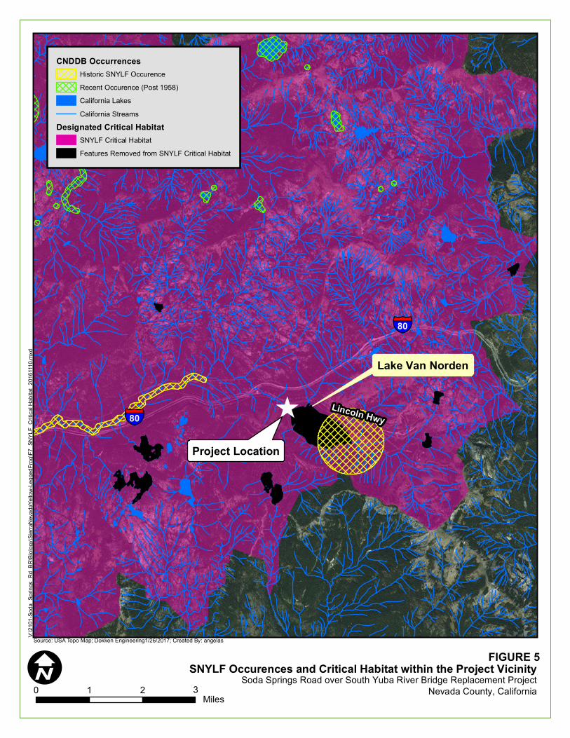
I0 1 2Miles
Source: USA Topo Map; Dokken Engineering1/26/2017; Created By: angelas
§̈¦80
§̈¦80Lincoln Hwy)
Lake Van Norden
V:\21
01-S
oda_
Sprin
gs_R
d_BR
\Biolo
gy\Si
erraN
evad
aYell
ow-Le
gged
Frog\F
7_SN
YLF_
Critic
al Ha
bitat_
2016
1110.m
xd
FIGURE 5SNYLF Occurences and Critical Habitat within the Project Vicinity
Soda Springs Road over South Yuba River Bridge Replacement Project3 Nevada County, California
CNDDB OccurrencesHistoric SNYLF OccurenceRecent Occurence (Post 1958)California LakesCalifornia Streams
Designated Critical HabitatSNYLF Critical HabitatFeatures Removed from SNYLF Critical Habitat
Project Location

Soda Springs Road over South Yuba River Replacement Project 29 of 63
June 2017
to water quality should potential increases in turbidity and, accidental spills of hazardous chemicals and
materials into water. Should SNYLF occur within the project area, indirect effects would be associated
with the replacement of the bridge over the natural bottomed South Yuba River and adjacent montane
riparian habitat. As discussed in Section 4.1.1.2., the project will have minor temporary and permanent
impacts to the South Yuba River and adjacent montane riparian habitat. With the implementation of
minimization and avoidance measures, the project will minimize potential effects to SNYLF.
Sierra Nevada Yellow-Legged Frog Critical Habitat
Critical Habitat for endangered species is identified by the physical and biological features that are
essential to the conservation of the species, and which require special management considerations or
protection. On August 26, 2016 USFWS published the Final Rule Critical Habitat designation (50 CFR
Part 17) for SNYLF (Figure 5. SNYLF Occurrences and Critical Habitat within the Project Vicinity).
Within the Final rule, the USFWS eliminated Lake Van Norden, within the Subunit 2C. Black Buttes as
Critical Habitat; however, the South Yuba River has been designated as Critical Habitat (USFWS 2016a,
USFWS 2013).
Critical Habitat for the SNYLF within the project area is as permanent high-elevation aquatic habitat and
adjacent lands that provide space for normal behavior and population growth. These aquatic habitats must
support a sustainable food web with a sufficient prey base, an absence of competition from introduced
fishes, exposure to solar radiation for basking, and require conditions that allow for overwinter survival
(water bodies that do not freeze to the bottom or refugia within or adjacent to such systems). Additionally,
habitats need the persistence of breeding and rearing areas and habitat connectivity of a diverse multi-
watershed (generally fish free) system throughout the extant of the species’ range (USFWS 2016c).
Based on USFWS 2016 Critical Habitat maps, the project is located within designated Critical Habitat for
the species (USFWS 2016b and USFWS 2016c). The South Yuba River potentially affected by the
project is designated within SNYLF Critical Habitat 2C (USFWS 2016c) (see Figure 5).
Primary constituent elements (PCEs) are the physical and biological features of that provide for a species’
life-history processes and are essential to the conservation of the species. PCE’s located within the project
area include PCE-2 (Aquatic, Non-breeding [including over-wintering] Habitat), permanent water body
(South Yuba River) and PCE-3 (Upland Areas) providing movement and feeding (montane riparian)
(Figure 6. SNYLF Critical Habitat PCE’s within the BSA). However, based on the habitat assessment and
focused survey for SNYLF in June 2015, a combination of variables (high volume flows from Lake Van
Norden (located less than 500 feet south east of the project area), lack of exposed banks and basking
areas, and the Project’s proximity to urban infrastructure) reduces the habitat quality of PCEs within the
project area.
Conclusion
The BSA is designated within the SNYLF Critical Habitat 2C (USFWS 2016c). The project will have
temporary and permanent affects to the South Yuba River and adjacent areas defined as Aquatic
Nonbreeding Habitat and Upland Areas Critical Habitat PCE’s. The proposed project is anticipated to
permanently affect less than 0.01 acres and temporarily affect approximately 0.05 acres of the South
Yuba River (Aquatic Nonbreeding Habitat) and would permanently affect approximately 0.03 acres and
temporarily affect 0.10 acre of montane riparian (Upland). Therefore, the project would have a total of
0.03 acres of permanent and 0.15 acres of temporary effects to SNYLF Critical Habitat. However, based
on the habitat assessment and focused survey for SNYLF in June 2015, habitat quality of the PCEs within
the project area is disturbed and marginally suitable for the SNYLF. In addition, the project is less than
500 feet northwest of Lake Van Norden, which the USFWS previously considered during their proposed
Critical Habitat ruling, but ultimately determined to eliminate the lake from the Final Critical Habitat
designation.
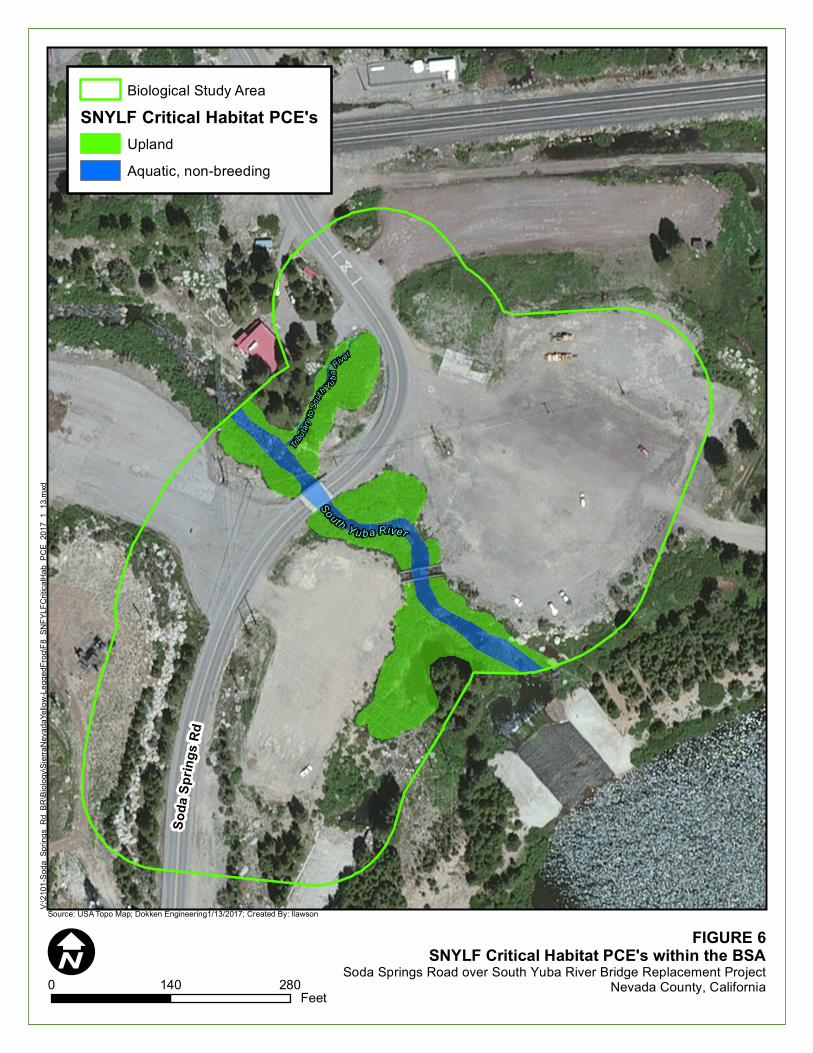
I0 140 280
Feet
Source: USA Topo Map; Dokken Engineering1/13/2017; Created By: llawson
Tributa
ryto
South
Yu baRive r
Soda
Sprin
gsRd
South Y u ba River
V:\21
01-S
oda_
Sprin
gs_R
d_BR
\Biolo
gy\Si
erraN
evad
aYell
ow-Le
gged
Frog\F
8_SN
FYLF
Critic
alHab
_PCE
_201
7_1_
13.m
xd
FIGURE 6SNYLF Critical Habitat PCE's within the BSA
Soda Springs Road over South Yuba River Bridge Replacement ProjectNevada County, California
Biological Study AreaSNYLF Critical Habitat PCE's
UplandAquatic, non-breeding
Soda Springs Road over South Yuba River Replacement Project 31 of 63
June 2017
Further, as a benefit to the channel, the project will remove the existing concrete piers from the South
Yuba River, creating improved flows and increased hydraulic capacity. Additionally, following
construction, the project would restore temporarily disturbed areas to pre-project conditions. The project
will be requesting USFWS concurrence with the determination that the project may affect, but is not
likely to adversely modify SNYLF Critical Habitat. Caltrans believes this is the appropriate determination
based on following reasons: the disturbed habitat value of SNYLF Critical Habitat PCEs, the close
proximity to Lake Van Norden (excluded from the Final SNYLF Critical Habitat 2C unit), the small
amount of disturbance to the South Yuba River and adjacent riparian habitat, the channel benefits from
the permanent removal of the existing concrete piers from the South Yuba River, the planned restoration
of temporarily disturbed areas to pre-project conditions, and implementation of site specific avoidance
and minimization measures.
To ensure the project minimizes and avoids potential adverse effects to SNYLF, BMP avoidance
Measure 4A will be implemented. In addition, species-specific mitigation Measure 4B has been
incorporated to minimize and avoid impacts to SNYLF; therefore, this impact is less than significant
with mitigation.
Southern Long-Toed Salamander
The Southern Long-Toed Salamander (Ambystoma macrodactylum sigillatum) is a CDFW species of
special concern. Within California, this species occurs in the Northeast and along the Northern Sierra
Nevada, south to Garner Meadows and Spicer Reservoir, and in Trinity and Siskiyou Counties near the
Trinity Alps. This species inhabits high mountain ponds and lakes, and alpine meadows at elevations up
to approximately 10,000 feet. Adults utilize tunnels burrowed out by mammals, such as moles and ground
squirrels, and spend much of their lives underground. Fully-developed adults can be found underneath
wood, logs, rocks, bark, and other objects in close proximity to breeding sites. Migration of adults and
juveniles to breeding sites occur in winter and spring, returning to wintering sites in the fall. Adults
become sexually mature between the ages of 1-3 years, with reproduction being fully aquatic and taking
place in permanent or temporary ponds, lakes, and flooded meadows (California Herps, 2016).
Survey Result
The South Yuba River is present within the BSA, which can act as suitable breeding habitat for the
species. A meadow, located just outside of the BSA, and Lake Van Norden, located approximately 300
feet upstream from the BSA, are suitable habitats for the species as well. The Southern Long-Toed
Salamander is considered to a have a low to moderate potential for occurring within the BSA. The species
was not observed during biological surveys but may still occur within the BSA due to presence of suitable
habitat and nearby recorded occurrences of the species.
Conclusion
Although no southern long-toed salamander was observed during the biological surveys, the species does
have a low to moderate potential due to recent known documented occurrences. Potential construction
related direct effects to the species include accidental spills of hazardous chemicals and materials into
water. Indirect effects include impacts associated with the removal of potential habitat, including rocks,
logs, and bark, in close proximity to South Yuba River. With the implementation of minimization and
avoidance measures, the project will minimize any potential effects to Southern Long-Toed Salamander.
Potential effects to southern long-toed salamander would be minimized and avoided through the use of
project Measure 4A and Measure 4B; therefore, this impact is less than significant with mitigation.
Willow Flycatcher
The willow flycatcher is state listed as endangered. Nesting habitat for willow flycatcher consists of dense
riparian systems comprised of willows, alders, cottonwoods or other riparian deciduous vegetation in
close proximity to water features including ponds, wetlands and backwaters. Diet for willow flycatcher is

Soda Springs Road over South Yuba River Replacement Project 32 of 63
June 2017
predominately flying insects with elderberry or blackberry when in season (Craig 1998). Breeding occurs
between April to August. The decline of the species is commonly due to parasitism by brown-headed
cowbirds (Molothrus ater) and a loss of habitat.
Survey Results
The BSA contains dense riparian vegetation dominated by willows and alders along both banks of the
South Yuba River upstream and downstream of the proposed bridge. Several occurrences of the species
have been documented along Lake Van Norden marsh habitat within dense willow shrubs (ebird 2016 and
CNDDB 2016). The habitat within the BSA lacks marsh environments preferred by the species; however,
the BSA does contain dense willow and alder riparian corridor along the South Yuba River adjacent to the
existing bridge. The BSA contains a small area of potentially suitable foraging and nesting habitat for the
species; therefore the species has a potential to occur. During the July 2015 biological surveys, no willow
flycatcher was observed or heard.
Conclusion
The project will affect potentially suitable foraging and nesting habitat. However, during the project
biological surveys, no willow flycatcher was observed or heard within the BSA. Considering all
vegetation suitable for willow flycatcher nesting would be removed outside the nesting season and the
implementation of project specific minimization and avoidance measures, the project will not result in
take of willow flycatcher.
Potential effects to willow flycatcher would be minimized and avoided through the use of project
Measure 4B; therefore, this impact is less than significant with mitigation.
Yellow Warbler
The yellow warbler is a CDFW Species of Special Concern. The species occurs in riparian woodlands,
montane chaparral, and open ponderosa pine and mixed conifer habitats with substantial amounts of
brush. Diet of the yellow warbler consists of insects including caterpillars, beetles, wasps and other
insects. Breeding occurs between mid-April to early August with a peak in June. The decline of the
species is commonly due to the parasitism by the brown-headed cowbirds.
Survey Results
The BSA contains riparian vegetation and mixed conifer habitats within the BSA. The nearest
occurrences of the species have been documented approximately 3.9 miles south of the project site. The
habitat within the BSA contains riparian environments preferred by the species and the South Yuba River,
potentially suitable for foraging and nesting; therefore, the species has a high potential to occur within the
BSA. During the July 2015 biological surveys, no yellow warbler was observed or heard.
Conclusion
The project will affect potentially suitable foraging and nesting habitat. However, during the project
biological surveys, no willow flycatcher was observed or heard within the BSA. Considering all
vegetation suitable for willow flycatcher nesting would be removed outside the nesting season and the
implementation of project specific minimization and avoidance measures, the project will not result in
take of willow flycatcher.
Potential effects to yellow warbler would be minimized and avoided through the use of project Measure
4B; therefore, this impact is less than significant with mitigation.
Impact Discussion 4b: Field surveys identified approximately 0.72 acres of montane riparian vegetation
within the BSA. The montane riparian vegetation is located adjacent to South Yuba River (see Figure 4:
Waters and Vegetation Communities within the BSA). The project will permanently affect 0.03 acres and
temporarily affect 0.10 acres of montane riparian habitat. The proposed project will minimize impacts to

Soda Springs Road over South Yuba River Replacement Project 33 of 63
June 2017
montane riparian area with the use of avoidance and minimization Measure 4A; therefore, this impact is
less than significant with mitigation.
Impact Discussion 4c: No wetland features are within the BSA. The proposed project would not result in
the direct removal, fill or hydrological interruption of federally protected wetland; therefore, no impact is
anticipated to federally protected wetlands.
Impact Discussion 4e: The South Yuba River may serve as a migration corridor for aquatic and terrestrial
species within the region, and may serve as an important dispersal corridor for aquatic animals such as
fish, turtles, and amphibians. Although Environmentally Sensitive Area fencing will be constructed along
project boundaries to protect the South Yuba River and montane riparian habitat, the remainder of the
project will remain open for wildlife movement. Additionally, no new lighting on the bridge is
anticipated. Multiple impassible barriers to migrating fish exclude anadromous fish from the project.
Therefore, the project affects to migratory wildlife corridors is less than significant.
Impact Discussion 4f: A number of local policies and ordinances that protect biological resources exist in
Nevada County; however, they are not applicable to the project. Therefore, no impact will conflict with
any local policies or ordinances.
Impact Discussion 4g: The proposed project will result in a temporary increase in noise and human
activity during the construction phase of the project. The project area is located along an existing county
road and construction activities would occur during daylight hours. Daytime noise impacts on wildlife
from construction activities are not anticipated to be substantial because most activities would occur near
the existing roadway with the nearest residence approximately 750 feet away where noise and activity
already commonly occurs (see Noise Section 12). Therefore, this impact would be less than significant.
Mitigation: To offset the potential biological impacts associated with the project construction, the
following avoidance and minimization measures will be required for all biological communities except
barren areas:
Measure 4A: Avoid impacts to riparian and other sensitive biological habitats. Project effects to
South Yuba River and associated riparian habitat will be avoided to the greatest extent practicable by
implementing the following measures:
BIO-1: Prior to the start of construction activities, the project limits in proximity to
jurisdictional waters (South Yuba River) will be marked with high visibility ESA
fencing or staking to ensure construction will not further encroach into waters. The
project biologist throughout construction will periodically inspect the ESA to ensure
sensitive locations remain undisturbed.
BIO-2: Contract specifications will include the following BMPs, where applicable, to
reduce erosion during construction:
Implementation of the project will require approval of a site-specific Storm
Water Pollution Prevention Plan (SWPPP) or Water Pollution Control Plan
(WPCP) that would implement effective measures to protect water quality, which
may include a hazardous spill prevention plan and additional erosion prevention
techniques;
Existing vegetation will be protected in place where feasible to provide an
effective form of erosion and sediment control; and

Soda Springs Road over South Yuba River Replacement Project 34 of 63
June 2017
Stabilizing materials will be applied to disturbed soil surfaces to prevent the
movement of dust from exposed soil surfaces on construction sites resulting from
wind, traffic, and grading activities.
Roughening and/or terracing will be implemented to create unevenness on bare
soil through the construction of furrows running across a slope, creation of stair
steps, or by utilization of construction equipment to track the soil surface.
Surface roughening or terracing reduces erosion potential by decreasing runoff
velocities, trapping sediment, and increasing infiltration of water into the soil,
and aiding in the establishment of vegetative cover from seed.
Soil exposure must be minimized through the use of temporary BMPs,
groundcover, and stabilization measures;
The contractor must conduct periodic maintenance of erosion- and sediment-
control measures.
BIO-3: To conform to water quality requirements, the SWPPP or WPCP will include the
following:
Vehicle maintenance, staging and storing equipment, materials, fuels, lubricants,
solvents, and other possible contaminants will be a minimum of 100 feet from
surface waters. Any necessary equipment washing will occur where the water
cannot flow into surface waters. The project specifications will require the
contractor to operate under an approved spill prevention and clean-up plan;
Construction equipment will not be operated in flowing water;
Construction work will be conducted according to site-specific construction plans
that minimize the potential for sediment input to surface waters;
Raw cement, concrete or concrete washings, asphalt, paint or other coating
material, oil or other petroleum products, or any other substances that could be
hazardous to aquatic life will be prevented from contaminating the soil or
entering surface waters;
Equipment used in and around surface waters will be in good working order and
free of dripping or leaking contaminants; and,
Any surplus concrete rubble, asphalt, or other debris from construction will be
taken to an appropriate disposal site.
BIO-4: All riparian areas and streambanks temporarily disturbed during project construction
will be restored onsite to pre-project conditions or better prior to project completion.
Where possible, vegetation will be trimmed rather than fully removed with the
guidance of the project biologist. When feasible riparian vegetation will be cut
above soil level.
BIO-5: Prior to arrival at the project site and prior to leaving the project site, construction
equipment that may contain invasive plants and/or seeds must be cleaned to reduce
the spreading of noxious weeds.
BIO-6: Should revegetation be installed within the project area, the project must not
incorporate Cal-IPC invasive species. Any revegetation treatments should
incorporate native plant materials to the maximum extent feasible.
Timing: Prior to and during construction
Reporting: Nevada County Department of Public Works
Soda Springs Road over South Yuba River Replacement Project 35 of 63
June 2017
Measure 4B: Avoid impacts to Special Status Species and local wildlife. Construction activities
associated with the proposed project may affect SNYLF and/or SNYLF Critical Habitat. As a result, the
project will implement the following measures into the project design to minimize and avoid potential
effects to aquatic wildlife.
BIO-7: Construction activities will be limited to daylight hours during the SNYLF active
period (approximately April-November).
BIO-8: Prior to initial ground disturbance activities, environmental awareness training will
be given to all construction personnel by the project biologist to brief them on how
to recognize SNYLF, and other sensitive species with potential to occur within the
project area. Construction personnel will also be informed that if a SNYLF is
encountered in the work area, construction will cease in work area and the USFWS
will be called for guidance before any construction activities are resumed. Personnel
will sign a form stating they attended environmental awareness training.
BIO-9: No more than 20 working days prior to any ground disturbance, preconstruction
SNYLF surveys will be conducted by a USFWS-approved biologist.
BIO-10: Water diversion pumps will utilize screening devices with low entry velocity to
minimize removal of aquatic species, including juvenile fish, amphibian egg masses
and tadpoles, from aquatic habitats.
BIO-11: If SNYLF are found at any time during project work, construction will stop in the
vicinity and USFWS will be contacted immediately for further guidance.
BIO-12: Plastic mono-filament netting (erosion control matting) or similar material
containing netting must not be used at the project. Acceptable substitutes include
coconut coir matting or tackified hydroseeding compounds.
BIO-13: Vegetation must be removed in the fall before onset of snow or early spring
immediately after the snow melts (approximately September 16th – April 14th).
Vegetation removal will be coordinated with the project biologist and the current
seasonal conditions.
BIO-14: If work will occur during the nesting season (April 15th – September 15th), a pre-
construction nesting migratory bird survey and a pre-construction nesting raptor
survey must be conducted by the project biologist within the project limits (plus an
approximate 600 foot buffer for raptors). A minimum 100 foot no-disturbance buffer
will be established around any active nest of migratory birds and a minimum 300
foot no-disturbance buffer will be established around any nesting raptor. The
contractor must immediately stop work in the nesting area until the appropriate
buffer is established and is prohibited from conducting work that could disturb the
birds (as determined by the project biologist and in coordination with wildlife
agencies) in the buffer area until the project biologist determines the young have
fledged. A reduced buffer can be established if determined appropriate by the project
biologist and approved by CDFW. Should a nesting willow flycatcher or other
sensitive bird species be identified within the project area, the project would pause
work in the vicinity and coordinate with CDFW for further guidance.
BIO-15: During the environmental phase of the project, a project biologist familiar with the
willow flycatcher call will perform two additional surveys between June 1 and July
15th pursuant to the 2003 survey protocol “A Willow Flycatcher Survey Protocol for
California”. Should surveys identify willow flycatcher within the BSA, the project
will conduct additional willow flycatcher coordination with CDFW.

Soda Springs Road over South Yuba River Replacement Project 36 of 63
June 2017
BIO-16: Prior to construction all known nesting cavities within the project limits must be
temporarily sealed with wire mesh to prevent the occupation of cavity nesting birds.
Following construction, wire meshing would be removed. Within the nesting season
(April 15th – September 15th) the project biologist must confirm each nest cavity is
unoccupied within 7 days prior to sealing or removal (if activities require the
removal of a utility pole or other structure with a cavity nest). Should relocation of
utilities be necessary, the project biologist would coordinate with the appropriate
utilities prior to relocation to ensure no cavity nesting birds would be affected.
BIO-17: If construction on the existing bridge is planned to occur during the swallow nesting
season, measures will be taken to avoid impacts to migratory swallows. To protect
migratory swallows, unoccupied nests must be removed from the existing bridge
structure prior to the nesting season (April 15th – September 15th). During the
nesting season, the bridge structure must be maintained through the active removal
of partially constructed nests. Swallows can complete nest construction in
approximately 3 days. After a nest is completed, it can no longer be removed until
an approved biologist has determined that all birds have fledged and the nest is no
longer being used.
BIO-18: If any wildlife is encountered during the course of construction, said wildlife will be
allowed to leave the construction area unharmed.
BIO-19: A pre-construction clearance survey will be conducted by the project biologist to
verify that no wildlife is located within the project area.
BIO-20: The contractor must dispose of all food-related trash in closed containers, and must
remove it from the project area each day during construction. Construction
personnel must not feed or attract wildlife to the project area.
Timing: Prior to and during construction
Reporting: Nevada County Department of Public Works

Soda Springs Road over South Yuba River Replacement Project 37 of 63
June 2017
5. CULTURAL RESOURCES
Existing Setting: The project vicinity was home to the Washoe Native American people. Washoe subsistence was marked
by adjusting resource exploitation dependent on the seasons. The Washoe left the Lake Tahoe area in late
summer and early fall to disperse in small groups to the valleys east of the Sierra to hunt antelope and
rabbit. The Washoe collected pine nuts along the eastern face of the Sierra and in the Pine Nut Mountains,
with deer hunting serving as an important ancillary activity in these locations.
During historic times, the discovery of gold caused an influx of miners into the Nevada County area.
Donner Pass was used by the California Trail, First Transcontinental Railroad, and the Lincoln Highway
to cross the mountains. The first group to cross this area was the Stephens-Townsend-Murphy Party in
November 1844.
The Soda Springs area has been a popular resting stop along the trail as early as 1864. Joseph Tinker and
Thomas Fenton, two of the original founding members of Soda Springs, built a hotel that year, called
Tinker’s Hotel at the intersection of the Dutch Flat Donner Lake Toll Wagon Road and a north/south trail
that corresponds with modern day Soda Springs Road.
The first ski resort in the area was Soda Springs Ski Area opened in 1926, which is southwest of the
project area. Opened by Oscar and Herstel Jones attracted winter sports enthusiasts by packing ski trails
and offering sleigh rides and is the longest running ski resort in California.
A Historic Property Survey Report (HPSR) and an Archeological Survey Report (ASR) were prepared to
document cultural resources within the project’s Area of Potential Effects (APE). The HPSR/ASR
provides much of the information used in this section; however, due to sensitive and confidential
information within the documents, they are not available for public review.
Would the proposed project: Potentially
Significant
Impact
Less Than
Significant with
Mitigation
Less Than
Significant
Impact
No
Impact
a. Cause a substantial adverse change in the significance
of a historical resource as defined in Section 15064.5 of the
CEQA Guidelines?
b. Cause a substantial adverse change in the significance
of an archaeological resource pursuant to Section 15064.5
of the CEQA Guidelines?
c. Directly or indirectly destroy a unique paleontological
resource or site or unique geologic feature?
d. Disturb any human remains, including those interred
outside of formal cemeteries?
Impact Discussion 5a-c: Archaeological surveys and search of archaeological site records and survey
reports on file at the North Central Information Center indicated that there were no cultural resources
within the area of potential effect (APE). On March 2, 2015, Dokken Engineering sent a letter and a map
of the project vicinity to the Native American Heritage Commission (NAHC) in West Sacramento, in
order to review sacred land files for any Native American cultural resources that might be affected by the
project. On March 19, 2015, Katy Sanchez informed Dokken Engineering via fax that a review of the
sacred lands file failed to indicate the presence of Native American cultural resources in the “immediate
project area”. Native American consultation letters were sent out on April 6, 2015 to the Native American
individuals on the list provided by the NAHC. For those who did not respond by letter a phone call was
placed on June 8, 2015 and June 18, 2015. No Native American individuals requested further consultation
on the project. In addition, an archaeological field investigation was conducted on July 1, 2015 by Brian
Marks (Ph.D.), and did not result in the identification of any cultural resources. The proposed project

Soda Springs Road over South Yuba River Replacement Project 38 of 63
June 2017
would be situated entirely within an area previously disturbed by construction and maintenance of the
existing bridge, roadway, and parking lot construction. As with any project that involves subsurface
excavation, there is the potential for accidental discovery of previously unidentified cultural resources.
Inclusion of Measure 5A into the project design will reduce potentially significant impacts to less than
significant levels with mitigation incorporated.
Impact Discussion 5d: Disturbance to human remains, including those interred outside of formal
cemeteries is not anticipated because no cemetery is documented within the Project Area. The Project
Area is previously disturbed from previous roadway construction, and there are no documented historic
resources within 1/2-mile of the project APE. With the inclusion of Measure 5D, project impacts to
human remains are anticipated to be less than significant with mitigation incorporated.
Mitigation: To offset potentially adverse cultural or historical resource impacts associated with the
proposed activities on site, the following avoidance and minimization measure will be required:
Measure 5A: Avoid impacts to sensitive cultural resources. Halt work and contact the appropriate
agencies if cultural resources are discovered during project construction. To prevent cultural resource
disturbance the following measures will be implemented.
CUL-1: Prior to construction, environmental awareness training will be provided to all
construction workers onsite regarding the possibility of encountering subsurface
cultural resources. Native American groups have expressed concerns regarding the
Native American resources in the immediate area. The Colfax-Todds Valley
Consolidated Tribe will be notified at least 2 weeks prior to construction to allow for
the tribe to monitor, if they choose to do so. Continued consultation will continue
throughout the course of the project.
CUL-2: If previously unidentified cultural materials are unearthed during construction, work
shall be halted in that area until a qualified archaeologist can assess the significance
of the find and develop a plan for documentation and removal of resources, if
necessary. Additional archaeological survey will be needed if project limits are
extended beyond the present survey limits.
Measure 5D: Avoid impacts to human remains. Halt work and contact the Nevada County Coroner if
human remains are discovered during project construction. To prevent disturbance to previously
undiscovered human remains, the following measures will be implemented.
CUL-3: Section 5097.94 of the Public Resources Code and Section 7050.5 of the California
Health and Safety Code protect Native American burials, skeletal remains and grave
goods, regardless of age and provide method and means for the appropriate handling
of such remains. If human remains are encountered, California Law requires that
work should halt in that vicinity and the Nevada County Coroner should be notified
immediately to assess the remains. If the coroner determines the human remains to
be of Native American origin, the coroner must notify the Native American Heritage
Commission (NAHC) within twenty-four hours of such identification. The NAHC
shall then determine the Most Likely Descendant (MLD) of the human remains and
contact the MLD immediately. The County, the MLD, and a professional
archaeologist retained by the County shall then consult to determine the appropriate
plans for treatment and assessment of the human remains and any associated grave
goods.
Timing: During construction
Reporting: Nevada County Department of Public Works

Soda Springs Road over South Yuba River Replacement Project 39 of 63
June 2017
6. GEOLOGY / SOILS
Existing Setting: The geology of the area consists of Mesozoic Metavolconic rocks, granitic formations,
and glacial deposits. The BSA is in the Soda Springs USGS 7½ minute quadrangle (T17N & R14E, S23).
Mountains and lakes including Lake Van Norden approximately 480 feet south of the project area
characterize topographical features in the project vicinity. Soil units within the BSA include Aquolls and
Borolls, 0 to 5 percent slopes, and Tallac-Cryumbrepts, wet complex, 2 to 30 percent slopes. Soils within
the BSA are very poorly drained to moderately well drained and have a medium runoff class. Depth to
water table is more than 130 inches (NRCS 2016). The County’s Master Environmental Inventory shows
the project site as being in an area of low potential for landslide or erosion activity and does not map the
site as being near a known earthquake fault (DOC 2010).
Would the project: Potentially
Significant
Impact
Less Than
Significant
with
Mitigation
Less Than
Significant
Impact
No
Impact
a. Expose people or structures to potential substantial adverse
effects, including the risk of loss, injury, or death involving:
i) Rupture of a known earthquake fault, as delineated on
the most recent Alquist-Priolo Earthquake Fault Zoning
Map issued by the State Geologist for the area or based
on other substantial evidence of a known fault?
ii) Strong seismic ground shaking?
iii) Seismic-related ground failure, including liquefaction?
iv) Landslides?
b. Result in substantial soil erosion or the loss of topsoil?
c. Be located on a geologic unit or soil that is unstable, or that
would become unstable as a result of the project, and potentially
result in on- or off-site landslide, lateral spreading, subsidence,
liquefaction or collapse?
d. Be located on expansive soil, as defined in Table 18-1-B of
the Uniform Building Code (1994), creating substantial risks to
life or property?
e. Have soils incapable of adequately supporting the use of
septic tanks or alternative waste water disposal systems where
sewers are not available for the disposal of waste water?
Impact Discussion 6a.i: The Project Area is not located on or near any known earthquake fault identified
on the Alquist-Priolo Earthquake Fault Zoning Map. The nearest fault zone is approximately 30 miles
from the project area (CGS 2015). No impact to known faults are anticipated.
Impact Discussion 6a.ii: The Project may generate minor amounts of surface ground shaking during
bridge demolition, but the nearest residence is approximately 750 feet from the project area. Any ground
shaking or vibration generated by the project is expected to dissipate and have no impact on local
residents.
Impact Discussion 6a.iii: Liquefaction is most commonly caused by strong seismic shaking affecting
saturated fine sand, silt or clay soils. Soils within the BSA are very poorly drained to moderately well
drained and have a medium runoff class. Lateral spreading, ground failure, or liquefaction are not
anticipated and the project will have no impact on seismic related ground failure.
Impact Discussion 6a.iv: The Project area is substantially flat other than minor slopes of the South Yuba
River banks. Additionally, the Project is not within a known area prone to landslide (CGS 2015);

Soda Springs Road over South Yuba River Replacement Project 40 of 63
June 2017
therefore, No impact to exposure of humans or structures to landslides is anticipated.
Impact Discussion 6b: The Project will remove vegetation on the banks of the South Yuba River,
potentially destabilizing these slopes. BMPs described in Measure 4A will minimize potential for erosion
and sediment transport during and post construction. In addition, the Project Area is greater than 1 acre in
size and the County will be required to obtain a 402 general construction permit for the Project. As a part
this permitting process, a Stormwater Pollution Prevention Plan (SWPPP) will be developed to protect
surface waters and prevent erosion and sediment transport. The Project related loss of topsoil or erosion
will be less than significant with mitigation incorporated.
Impact Discussion 6c: Soil units within the Project Area are considered stable and not prone to lateral
spreading, subsidence, liquefaction or collapse. The Project Area is not located on or near any large
slopes susceptible to landslides. Vegetation will be removed from the banks of South Yuba River within
the Project Area, potentially destabilizing the soil; however, BMPs and post construction re-vegetation
efforts described in Measure 4A will ensure that long-term project impacts to unstable soils will be less
than significant with mitigation.
Impact Discussion 6d: Expansive soils are typically comprised of heavy clays that expand and contract as
water content changes. The soil types found within the Project Area typically well drained and not
classified as expansive soils. The project would have no impact on creating risk associated with
expansive soils.
Impact Discussion 6e: The project site does not have septic tanks or alternative wastewater disposal
systems and will not add such facilities. No impact is anticipated to result from project implementation to
soils supporting the use of septic tanks or wastewater disposal systems.
Mitigation: To offset the potential for significant impacts related to erosion/sediment transport and
landslides, soil stabilization discussed in Measure 4A will be implemented.

Soda Springs Road over South Yuba River Replacement Project 41 of 63
June 2017
7. GREENHOUSE GAS EMISSIONS
Existing Setting: Greenhouse gases (GHGs) are those gases that trap heat in the atmosphere. GHGs are
emitted by natural and industrial processes, and the accumulation of GHGs in the atmosphere regulates
the earth’s temperature. GHGs that are regulated by the State and/or Environmental Protection Agency
(EPA) are carbon dioxide (CO2), methane (CH4), hydrofluorocarbons (HFCs), perfluorocarbons (PFCs),
sulfur hexafluoride (SF6) and nitrous oxide (NO2). CO2 emissions are largely from fossil fuel combustion.
In California, approximately 43 percent of the CO2 emissions come from cars and trucks. Electricity
generation is another important source of CO2 emissions. Agriculture is a major source of both methane
and NO2, with additional methane coming primarily from landfills. Most HFC emissions come from
refrigerants, solvents, propellant agents and industrial processes, and persist in the atmosphere for longer
periods of time and have greater effects at lower concentrations compared to CO2. The adverse impacts of
global warming include impacts to air quality, water supply, ecosystem balance, sea level rise (flooding),
fire hazards, and an increase in health related problems.
Assembly Bill 32 (AB 32), the California Global Warming Solutions Act, was adopted in September
2006 and requires that statewide GHG emissions be reduced to 1990 levels by the year 2020. This
reduction will be accomplished through regulations to reduce emissions from stationary sources and from
vehicles. The California Air Resources Board (ARB) is the State agency responsible for developing rules
and regulations to cap and reduce GHG emissions. In addition, the Governor signed Senate Bill 97 in
2007 directing the California Office of Planning and Research to develop guidelines for the analysis and
mitigation of the effects of greenhouse gas emissions and mandating that GHG impacts be evaluated in
CEQA documents. CEQA Guidelines Amendments for GHG Emissions were adopted by OPR on
December 30, 2009. The NSAQMD has prepared a guidance document, Guidelines for Assessing Air
Quality Impacts of Land Use Projects. Therefore, in order to satisfy CEQA requirements, projects should
make a reasonable attempt to quantify, minimize and mitigate GHG emissions as feasible.
Would the project: Potentially
Significant
Impact
Less Than
Significant
with
Mitigation
Less Than
Significant
Impact
No
Impact
a. Generate greenhouse gas emissions, either directly or
indirectly, that may have a significant impact on the
environment?
b. Conflict with any applicable plan, policy or regulation of an
agency adopted for the purpose of reducing the emissions of
greenhouse gases?
Impact Discussion 7a-b: CO2e is Carbon Dioxide Equivalent, a measurement that expresses units of
different greenhouse gases as equivalent to units of carbon dioxide in the ability to affect global warming.
For that reason, CO2e is evaluated here.
Given the complex interactions between various global and regional-scale physical, chemical,
atmospheric, terrestrial, and aquatic systems, it is not possible to determine to what extent this project’s
CO2 emissions would result in any altered physical conditions. Typically, cumulative impacts are
analyzed and mitigated in the County’s General Plan and associated EIR. In this case, the General Plan
for Nevada County does not address GHG Emissions. Additionally, no thresholds have been adopted by
the County, the NSAQMD, or the State, for project-specific greenhouse gas emission impacts. However,
it is possible to determine the level of GHG emissions that would result from the project and to disclose
that figure and its potential impact using other jurisdictions’ adopted thresholds. Several air districts in the
State of California have adopted thresholds in the range of 1,100 MT CO2e/year for de minimis impacts
(i.e., project impacts below 1,100 MT CO2e/year would be less than significant) and 10,000 MT

Soda Springs Road over South Yuba River Replacement Project 42 of 63
June 2017
CO2e/year for significant and unavoidable impacts. These standards apply to both construction and
operation of project.
The proposed project is anticipated to result in temporary increases in CO2e levels due to construction
equipment. Equipment anticipated for construction includes an excavator, concrete truck, transportation
truck, and backhoes. The total site disturbance will be approximately 3.18 acres and will include grading
for the roadway, fill for the bridge structure and storage areas. Total CO2e generated by project
construction would be approximately 385.49 metric tons (MT) per year. Long-term operational impacts
related to CO2e emissions are not anticipated to be higher than under existing conditions because the
bridge improvement project would facilitate circulation and movement and would not increase density or
development potential. Therefore, both construction and operational greenhouse gas emissions resulting
from the project are anticipated to be less than significant.

Soda Springs Road over South Yuba River Replacement Project 43 of 63
June 2017
8. HAZARDS / HAZARDOUS MATERIALS
Existing Setting: The property is not within or adjacent to any hazardous materials sites compiled
pursuant to Government Code Section 65962.5 (DTSC 2014), and is not located on an abandoned solid
waste disposal site known to the County Nevada County. The project area is designated as a High Fire
Hazard Area for wildland fire, and is bordered by Very High Fire Hazard Areas (Nevada County 2017).
Would the project: Potentially
Significant
Impact
Less Than
Significant
with
Mitigation
Less Than
Significant
Impact
No
Impact
a. Create a significant hazard to the public or the environment
through the routine transport, use, or disposal of hazardous
materials?
b. Create a significant hazard to the public or the environment
through reasonably foreseeable upset and accident conditions
involving the release of hazardous materials into the
environment?
c. Emit hazardous emissions or handle hazardous or acutely
hazardous materials, substances, or waste within one-quarter mile
of an existing or proposed school?
d. Be located on a site which is included on a list of hazardous
materials sites compiled pursuant to Government Code Section
65962.5 and, as a result, create a significant hazard to the public
or the environment?
e. For a project located within an airport land use plan or,
where such a plan has not been adopted, within two miles of a
public airport or public use airport, would the project result in a
safety hazard for people residing or working in the project area?
f. For a project within the vicinity of a private airstrip, would
the project result in a safety hazard for people residing or
working in the project area?
g. Impair implementation of or physically interfere with an
adopted emergency response plan or emergency evacuation plan?
h. Expose people or structures to a significant risk of loss,
injury or death involving wildland fires, including where
wildlands are adjacent to urbanized areas or where residences are
intermixed with wildlands?
Impact Discussion 8a: No additional transport, use, or disposal of hazardous materials is anticipated as a
result of the project; therefore, there will be no impact to the public or environment related to hazardous
materials.
Impact Discussion 8b: A search of federal, state, and local regulatory agency databases was conducted by
Environmental Data Resources, Inc. (EDR) for records of hazardous material within the study area.
Search distances varied for different databases, with a minimum search distance of 1/4-mile from the
study area. In addition, a visual survey of the project area was conducted on March 14, 2015 to identify
potentially hazardous materials within the Project Area. According to the EDR report, a Leaking
Underground Storage Tank (LUST) site is shown to be within the study area. However, the LUST site is
listed as the Soda Springs Ski Area, which is immediately adjacent southwest of the actual study area and
not actually within it. Therefore, the proposed project would not impact a known hazardous waste site and
no known hazardous waste sites exist within the study area.
On August 6, 2015 Entek assessed existing paints and applied coatings in an effort to determine if lead

Soda Springs Road over South Yuba River Replacement Project 44 of 63
June 2017
was present in these materials and conducted an asbestos inspection of the existing concrete associated
with the bridge structure. No paints or coatings associated with the bridge structure were observed. In
addition, on August 6, 2015 Entek took four (4) bulk samples of various materials suspected to contain
asbestos. The samples were evaluated and none were determined to contain detectable asbestos.
Further analysis and evaluation of sources of aerially deposited lead (ADL) were conducted on June 6th,
2016 by Geocon Consultants, Inc. Eleven (11) soil samples were collected for lead analysis and based on
testing results, no hazardous levels of ADL were identified within the project limits.
Geocon Consultants identified a potential recognized environmental condition (REC) with respect to
Naturally Occurring Asbestos (NOA) through testing of soil samples from hand augured borings and
determined a potential for aerial dispersion of NOA as a result of construction activities. Based on the
presence of fill containing serpentinized rocks and the associated presence of NOA, engineering controls
may be required for work at the site to minimize the potential aerial dispersion of NOA as described in
CCR 93105. Mitigation Measure 8B will be implemented to avoid and minimize any impacts from
hazardous NOA materials.
Concrete, gasoline, diesel fuel, paint, oil, and other petroleum products will be used during construction
of the project but would be transported in less than reportable quantities. The County and the contractor
would be responsible for preventing harmful chemicals including gasoline, diesel fuel, paint, oil, other
petroleum products, and other substances that could be deleterious to aquatic life from contaminating the
soil and/or entering South Yuba River. Mitigation Measure 8B, will be implemented to prevent and
minimize impacts if any spill of contaminants occur during construction, and to minimize the potential for
impacting public health by use of a spill cleanup kit. Release of hazardous materials is anticipated to be
less than significant with mitigation incorporated.
Impact Discussion 8c: The project area is not within one-quarter mile of an existing or proposed school.
Therefore, there would be no impact related to hazardous emissions or substances near a school.
Impact Discussion 8d: The proposed project site is not included on a list of hazardous materials sites
compiled pursuant to Government Code Section 65962.5 and, as a result, will not create a significant
hazard to the public or the environment and will have no impact.
Impact Discussion 8e-f: The proposed project is not located within an airport land use plan and is not
located within 2 miles of a public airport or private air strip. The project will have no impact on public
safety in the vicinity of an airport or air strip.
Impact Discussion 8g: Soda Springs Road is the only year round access to the rural community south of
the Project Area from Donner Pass Road. Soda Springs Road is anticipated to remain open to traffic
during construction. The replacement bridge will be wider than existing conditions and will not restrict
emergency responders or emergency evacuation plans. The project will not impair long term emergency
use of the facility and is anticipated to have a less than significant impact to emergency use during
construction.
Impact Discussion 8h: The project area and surrounding area are considered high-risk areas for wildfires;
however, the project only involves replacing a roadway facility and will not increase exposure of people
and structures to fires. The project will have no impact to exposure of people or structures to fires.
Mitigation: To offset the potential for impacts related to storage, use, and transport and hazardous
materials, the following avoidance and minimization measures will be required:
Measure 8B: Minimize the release of hazardous materials into the environment. The following

Soda Springs Road over South Yuba River Replacement Project 45 of 63
June 2017
measure has been incorporated into the project design to ensure that hazardous materials generated by the
project are not released into the environment
HAZ-1: The contractor shall prepare spill and leak prevention procedures prior to the
commencement of construction activities. The procedures shall include information
on the nature of all hazardous materials that shall be used on-site. The procedures
shall also include information regarding proper handling of hazardous materials, and
clean-up procedures in the event of an accidental release. The phone number of the
agency overseeing hazardous materials and toxic clean-up shall be provided.
HAZ-2: The contractor(s) will prepare and implement an Asbestos Dust Management Plan
(ADMP) that describes measures that will be taken to mitigate the potential airborne
suspension of NOA-containing dust from the soil/rock, as a result of construction
excavation activities. Asbestos dust control to be implemented shall be in
compliance with the following:
CCR § 93105 (Asbestos Airborne Toxic Control measure for Construction,
Grading, Quarrying, and Surface Mining Operations (ATCM 930105);
CCR § 93106 ((Asbestos Airborne Toxic control measure for Surfacing
Applications (ATCM 93106));
Northern Sierra Air Quality Management District guidelines;
HAZ-3: According to Title 17 CCR, § 93106(i)(20), the soil/rock material within the
southwestern roadway shoulder of the site is considered Restricted Material because
the soil/rock material there contains asbestos at 0.25% or greater. Therefore, it
cannot be used under the definition of surfacing (Title 17 CCR, § 93106(i)(26)). As
required by the Title 17 CCR, § 93105(e)(4)(G), disturbed asbestos-containing
material (0.25% asbestos or greater) must be stabilized via options that include
paving or covering with at least 3 inches of non-asbestos-containing material (less
than 0.25% asbestos).
Any part, other than a permitted landfill, receiving NOA-containing soil must be
provided the following warning statement:
“WARNING!
This material may contain asbestos.
It is unlawful to use this material for surfacing or any application in which it
would remain exposed and subject to possible disturbance.
Extreme care should be taken when handling this material to minimize the
generation of dust.”
HAZ-4: As is the case for any project that proposes excavation, the potential exists for
unknown hazardous contamination to be revealed during project construction. For
any previously unknown hazardous waste/ material encountered during construction,
the procedures outlined in the Caltrans Unknown Hazard Procedures (as seen Table
7-1.1 of the Caltrans Construction Manual) shall be followed.
Timing: Prior to and during construction
Reporting: Nevada County Department of Public Works

Soda Springs Road over South Yuba River Replacement Project 46 of 63
June 2017
9. HYDROLOGY / WATER QUALITY
Existing Setting: The proposed project is within the designated South Yuba Hydrologic Area (HA),
which is within the greater Rattlesnake Creek-South Yuba River Hydrologic Unit (HU) subwatershed of
the Upper South Yuba River Watershed (Caltrans, 2016). The Rattlesnake Creek-South Yuba River HU
drains an area of approximately 97 thousand acres and extends 15 miles from Donner Pass within the
Sierra Nevada Mountains to Lake Spaulding.
South Yuba River is located within the project area. The South Yuba River originates approximately 3
miles east of the project from Lake Angela. South Yuba River flows into Lake Van Norden, outfalls the
lake 200 feet to the southeast of the project area, and flows through the project area.
A Water Quality Assessment Report (Dokken Engineering, 2017) was prepared to document water
quality information within the project area. The Water Quality Assessment provides much of the
information used in this section and may be consulted for further technical background.
Would the project: Potentially
Significant
Impact
Less Than
Significant
with
Mitigation
Less Than
Significant
Impact
No
Impact
a. Violate any water quality standards or waste discharge
requirements?
b. Substantially deplete groundwater supplies or interfere
substantially with groundwater recharge such that there would be
a net deficit in aquifer volume or a lowering of the local
groundwater table level (e.g., the production rate of pre-existing
nearby wells would drop to a level, which would not support
existing land uses or planned uses for which permits have been
granted)?
c. Substantially alter the existing drainage pattern of the site or
area, including through the alteration of the course of a stream or
river, in a manner that would result in substantial erosion or
siltation on- or off-site?
d. Substantially alter the existing drainage pattern of the site or
area, including through the alteration of the course of a stream or
river, or substantially increase the rate or amount of surface
runoff in a manner which would result in flooding on- or off-site?
e. Create or contribute to runoff water which would exceed the
capacity of existing or planned storm water drainage systems or
provide substantial additional sources of polluted runoff?
f. Otherwise substantially degrade water quality?
g. Place housing within a 100-year flood hazard area as
mapped on a federal Flood Hazard Boundary or Flood Insurance
Rate Map or other flood hazard delineation map?
h. Place within a 100-year flood hazard area structures that
would impede or redirect flood flows?
i. Expose people or structures to a significant risk of loss,
injury or death involving flooding, including flooding as a result
of the failure of a levee or dam?
j. Create inundation by seiche, tsunami, or mudflow?
Impact Discussion 9a: The project will disturb greater than one acre; therefore, a Construction Storm
Water General Permit is required, consistent with Construction General Permit Order No. 2009-009-
DWQ, issued by the State Water Resources Control Board to address storm water runoff. The permit will

Soda Springs Road over South Yuba River Replacement Project 47 of 63
June 2017
address clearing, grading, grubbing, and disturbances to the ground, such as stockpiling, or excavation.
This permit will also require the County to prepare and implement a SWPPP or WPCP to minimize
erosion, sediment transport, and other water quality impacts. In addition to the BMPs described in
Measure 4A, additional water quality BMPs discussed in Measure 9A have been incorporated into the
project design. Project impacts to water quality and water quality standards will be less than significant
with mitigation.
Impact Discussion 9b: The proposed project would not directly or indirectly result in the construction of
uses that would utilize groundwater supplies. Therefore, there would be no impact related to depletion of
groundwater supplies or interference with groundwater recharge.
Impact Discussion 9c-d: No substantial alterations of the existing drainage patterns on site will occur.
Drainage on the site will remain along natural drainage courses, similar to prior construction conditions.
The project storm water drainage would be designed consistent with County requirements and Caltrans
Project Planning and Design Guide and Storm Water Management Plan and will remain natural. The
project is anticipated to have a less than significant impact to erosion or flooding as a result of altered
drainage patters.
Impact Discussion 9e-f: The Project Area is not located within a developed area and does not flow into a
storm drain system. The project would result in an increase in paved surface area, which would increase
the volume of storm water runoff from the roadways surface that could eventually enter South Yuba
River. Roadways may contain oil, grease, petroleum projects, zinc, copper, lead, cadmium, iron, and other
trace metals, which could harm wildlife. Concentrations of these pollutants in storm water runoff would
be greatest during storm events. The project will not increase traffic capacity of the facility and additional
operational pollutant concentrations are not expected.
Construction activities associated with the project would include disturbances to the ground surface from
demolition and removal of the existing bridge, grading, and new bridge construction. Removal of the
existing riparian vegetation would increase the potential for slope erosion and suspended sediment load in
South Yuba River. In addition, operation of mechanized equipment near South Yuba River may increase
the risk of petroleum products, paints, and other construction related chemicals from accidentally entering
South Yuba River and negatively impacting wildlife, groundwater, and downstream water quality. Any
accidental spill would be minimal and not cause long-term water quality impacts.
The project may have short-term impacts associated with sediment and runoff during grading and
construction. Compliance with existing regulations and implementation of BMPs would reduce
potentially significant impacts associated erosion or siltation on- or offsite to levels less than significant.
Water quality BMPs discussed in Measure 4B and Measure 9A have been incorporated into the project
design. Project generated polluted runoff is anticipated to be less than significant with mitigation
incorporated.
Impact Discussion 9g: The project does not include construction of housing. No impact to housing within
the 100-year floodplain is anticipated.
Impact Discussion 9h: According to the Federal Emergency Management Agency (FEMA) Flood
Insurance Rate Map (FIRM), the project area is not located within a 100-year flood area of concern. The
project is within Zone D, which is an area that remains undetermined as a flood risk because no
assessment has been complete, and Lake Van Norden is typically inundated with large rain and snow
events. Impacts to floodplain would be reduced due to the project design in removing the existing in
channel pier, creating improved flows and increased hydraulic capacity. The project would not place any
structures within a 100-year flood hazard area; therefore, the project would have no impact related to
impeding or redirect flood flows.

Soda Springs Road over South Yuba River Replacement Project 48 of 63
June 2017
Impact Discussion 9i: The project does not involve work on or near levees or dams, and would not expose
people or structures to a significant risk of loss, injury or death involving flooding, including flooding as a
result of the failure of a levee or dam. The project will have no impact to levees or dams.
Impact Discussion 9j: The project area is not located near any lake susceptible to seiche fluctuations and
is located approximately 6,760 feet above mean sea level and 160 miles from the coast, well above the
reach of tsunamis. The project area is not located on any steep slopes that would put downslope properties
at risk of mudflows if destabilized. The Project is anticipated to have no impact on exposing people or
structures to inundation by seiche, tsunami, or mudflow.
Mitigation: To offset the potential for impacts related to alteration of slope and drainage features around
the Soda Springs Bridge and storm water quality from operational activities, the following avoidance and
minimization measures will be required, except within existing barren parking areas:
Measure 9A: Storm Water Best Management Practices. The proposed project has been designed to
minimize storm water impacts to the maximum extent practicable through the use of BMPs and
implementation of regulatory permit conditions.
WQ-1: BMPs will be incorporated into project design and project management to minimize
impacts on the environment including the release of pollutants (oils, fuels, etc.):
The area of construction and disturbance would be limited to as small an area
as feasible to reduce erosion and sedimentation.
Measures would be implemented during land-disturbing activities to reduce
erosion and sedimentation. These measures may include mulches, soil binders
and erosion control blankets, silt fencing, fiber rolls, temporary berms,
sediment desilting basins, sediment traps, and check dams.
Existing vegetation would be protected where feasible to reduce erosion and
sedimentation. Vegetation would be preserved by installing temporary fencing,
or other protection devices, around areas to be protected.
Exposed soils would be covered by loose bulk materials or other materials to
reduce erosion and runoff during rainfall events.
Exposed soils would be stabilized, through watering or other measures, to
prevent the movement of dust at the project site caused by wind and
construction activities such as traffic and grading activities.
All construction roadway areas would be properly protected to prevent excess
erosion, sedimentation, and water pollution.
All vehicle and equipment maintenance procedures would be conducted off-
site. In the event of an emergency, maintenance would occur away from the
South Yuba River.
All concrete curing activities would be conducted to minimize spray drift and
prevent curing compounds from entering the waterway directly or indirectly.
All construction materials, vehicles, stockpiles, and staging areas would be
situated outside of the stream channel as feasible. All stockpiles would be
covered, as feasible.
Energy dissipaters and erosion control pads would be provided at the bottom of
slope drains. Other flow conveyance control mechanisms may include earth

Soda Springs Road over South Yuba River Replacement Project 49 of 63
June 2017
dikes, swales, or ditches. Stream bank stabilization measures would also be
implemented.
All erosion control measures and storm water control measures would be
properly maintained until the site has returned to a pre-construction state.
All disturbed areas within the channel and associated banks would be restored
to pre-construction contours and revegetated, either through hydroseeding or
other means, with native or approved non-invasive exotic species.
All construction materials would be hauled off-site after completion of
construction.
WQ-2: Any requirements for additional avoidance, minimization, and/or mitigation
measures will be in contained in the permits obtained from all required regulatory
agencies.
WQ-3: The project limits in proximity to the South Yuba River will be marked as an
Environmental Sensitive Area (ESA) or either be staked or fenced with high
visibility material to ensure construction activities will not encroach further beyond
established limits.
WQ-4: The proposed project would require a National Pollution Discharge Elimination
System (NPDES) General Construction Permit for Discharges of storm water
associated with construction activities (Construction General Permit 2012-0006-
DWQ). As part of the Permit requirement, a Stormwater Pollution Prevention Plan
(SWPPP) or Water Pollution Control Program (WPCP) would also be developed and
implemented. The SWPPP or WPCP will incorporate all applicable BMPs to ensure
that adequate measures are taken during construction to minimize impacts to water
quality.
WQ-5: Post-construction storm water control requirements will be addressed in accordance
with Caltrans’ MS4 permit for areas within Caltrans right-of-way. Permanent
treatment control BMPs will be evaluated based on effectiveness and feasibility and
incorporated into the final design as applicable.
Timing: Prior and during construction
Reporting: Nevada County Department of Public Works

Soda Springs Road over South Yuba River Replacement Project 50 of 63
June 2017
10. LAND USE / PLANNING
Existing Setting: The project is located in the eastern side of Nevada County. The project is
approximately 750 feet south of the Lincoln Highway/Donner Pass Road and approximately 0.75 miles
southeast from Interstate-80. The topographic features in the project vicinity are characterized by Sierra
Nevada Mountains and water features. The project site contains the existing water feature, South Yuba
River. According to the Soda Springs Area Plan (2016), the project site and surrounding area is located
within the Soda Springs Rural Center. The Soda Springs Area Plan has recently updated land use
designations within the Plan Area. With these updates, the project site is specifically located in a
Recreation (REC) land use designation, with adjacent land uses of Urban Single Family (R1), Urban
Medium Density (R2-RC), Neighborhood Commercial (C1), Community Commercial (CC), and Forest
40-acre (FOR-40). The Soda Springs Area Plan updated land use designations are displayed in Figure 7
Soda Springs Area Plan Land Use Designations.
Would the project: Potentially
Significant
Impact
Less Than
Significant
with
Mitigation
Less Than
Significant
Impact
No
Impact
a. Physically divide an established community?
b. Conflict with any applicable land use plan, policy, or
regulation of an agency with jurisdiction over the project
(including, but not limited to the general plan, specific plan, local
coastal program, or zoning ordinance) adopted for the purpose of
avoiding or mitigating an environmental effect?
c. Conflict with any applicable habitat conservation plan or
natural community conservation plan?
Impact Discussion 10a: The Project consists of the replacement of an existing structure, which is
compatible with the existing land use. The roadway will remain open for the duration of construction and
will not divide any established community present along Soda Springs Road. The project would have no
impact on dividing communities.
Impact Discussion 10b: The Project will not affect land use, either in the surrounding area or regionally.
The new bridge will benefit the local and visiting recreation users and replace the structurally deficient
current bridge. No impact to the general plan is anticipated.
Impact Discussion 10c: There are no habitat conservation plans or natural community conservation plans
within Nevada County. No impact to habitat conservation plans or natural community conservation plans
will occur.
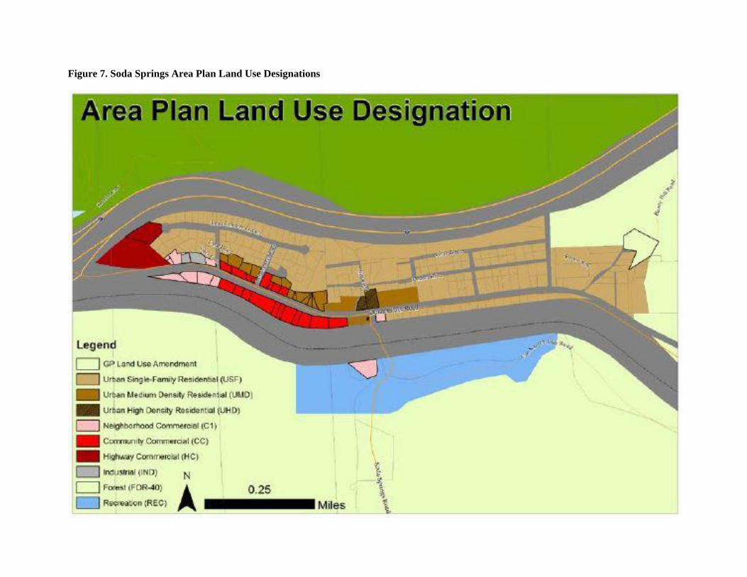
Figure 7. Soda Springs Area Plan Land Use Designations

Soda Springs Road over South Yuba River Replacement Project 52 of 63
June 2017
11. MINERAL RESOURCES
Existing Setting: Nevada County was part of the California gold rush in the late 1840s and early 1850s
with numerous historic mines throughout western Nevada County. The Project Area is not zoned for
mineral extraction nor are any adjacent lands within the project vicinity in mineral extraction land use
designations. The nearest mineral resource zone MRZ-2 land is located just outside of Truckee about 8.5
miles east of the project area. The nearest mineral extraction combining district is about 17 miles east.
Would the project: Potentially
Significant
Impact
Less Than
Significant
with
Mitigation
Less Than
Significant
Impact
No
Impact
a. Result in the loss of availability of a known mineral resource
that would be of value to the region and the residents of the state?
b. Result in the loss of availability of a locally important
mineral resource recovery site delineated on a local general plan,
specific plan or other land use plan?
Impact Discussion 11 a-b: The proposed project is not located within or near a mineral extraction
combining district. Mineral resources are not presumed to be present within the Project Area and the
Project would not change existing land uses on the project site. No impact to mineral resources are
anticipated.

Soda Springs Road over South Yuba River Replacement Project 53 of 63
June 2017
12. NOISE
Existing Setting: The project area is within a rural-residential area of Nevada County, which is an area
with moderate levels of existing noise due to existing commercial areas and roadways. The Nevada
County Noise Standards (Nevada County Land Use and Development Code, Section L-II 4.1.7) establish
exterior noise limits ranging from 40-90 dBA (A-weighted decibel) depending on land use categories
(rural, residential and public, commercial and recreation, business park, and industrial) (see Table below).
Nevada County Noise Standards
Exterior Noise Limits
Land Use
Category Zoning Districts Time Period
Noise Level, dBA
Leq Lmax
Rural AG, TPZ, AE, OS,
FR, IDR
7am - 7pm
7pm - 10pm
10pm – 7am
55
50
40
75
65
55
Residential and
Public
RA, R1, R2, R3, P 7am - 7pm
7pm - 10pm
10pm – 7am
55
50
45
75
65
55
Commercial and
Recreation
C1, CH, CS, C2,
C3, OP, REC 7am - 7pm
7pm - 10pm
70
65
90
75
Business Park BP 7am - 7pm
7pm - 10pm
65
60
85
70
Industrial M1, M2 Anytime 80 90
Construction noise is exempt from these standards. The nearest sensitive noise receptor to the project
vicinity is a single-family residence approximately 750 feet to the northeast of the project area. This
receiver is sufficiently far from the project area that no significant noise impact will occur.
Would the project result in: Potentially
Significant
Impact
Less Than
Significant
with
Mitigation
Less Than
Significant
Impact
No
Impact
a. Exposure of persons to or generation of noise levels in excess
of standards established in the local general plan or noise
ordinance, or applicable standards of other agencies?
b. Expose persons to or generate excessive ground borne
vibration or ground borne noise levels (e.g., blasting)?
c. A substantial permanent increase in ambient noise levels in
the project vicinity above levels existing without the project?
d. A substantial temporary or periodic increase in ambient noise
levels in the project vicinity above levels existing without the
project?
e. For a project located within an airport land use plan or, where
such a plan has not been adopted, within two miles of a public
airport or public use airport, would the project expose people
residing or working in the project area to excessive noise levels?
f. For a project within the vicinity of a private airstrip, would
the project expose people residing or working in the project area to
excessive noise levels?
Impact Discussion 12a: The project would replace the existing bridge with a facility in approximately the

Soda Springs Road over South Yuba River Replacement Project 54 of 63
June 2017
same location and will not increase the traffic capacity of the roadway. All noise impacts will be related
to construction of the project. Construction noise is exempt from local standards and ordinances;
therefore, the proposed project would not expose persons to noise levels in excess of standards established
in the local general plan or noise ordinance, and no impacts would occur.
Impact Discussion 12b: The proposed project would not result in blasting or other activities that could
cause substantial vibration impacts. Therefore, there would be no impact related to ground borne
vibration.
Impact Discussion 12c: The replacement bridge will be in approximately the same vertical and horizontal
alignment and will not increase the traffic capacity of the roadway. No impact from long-term or
operational noise is anticipated.
Impact Discussion 12d: The nearest potential noise receptor to the project site is a rural residence
approximately 750 feet to the northeast of the project area. Construction of the Project would result in a
temporary increase in the noise environment. During construction of the project, noise from construction
activities may intermittently dominate the noise environment in the immediate area of construction.
Construction equipment is expected to generate noise levels ranging from 70 to 90 dB at a distance of 50
feet, and noise produced by construction equipment would be reduced over distance at a rate of about 6
dB per doubling of distance. At a distance of 750 feet, construction related noise will decrease by
approximately 20 dBA and is anticipated to be less than the 75 dBA Lmax; therefore anticipated temporary
construction noise would be less than Lmax standards set for Nevada County, and construction activities
will not be continuous or significantly raise Leq. Additionally, construction activities are exempt from
County noise standards; however, given the increase in temporary noise from existing levels and to
minimize impacts to neighbors, Mitigation Measure NOI-1 will be implemented and impacts related to
temporary noise would be less than significant with mitigation.
Impact Discussion 12e - f: The project is not located in or within 2 miles of an airport boundary or in the
vicinity of a private air strip. No impact is anticipated.
Mitigation: To offset the potential for significant impacts related to the addition of temporary
construction noise within the vicinity of the project, the following measures will be required:
Measure 12D: Construction Work Hours. The proposed project has been designed to minimize
construction related noise impacts to neighboring residences within the project vicinity.
NOI-1: Project construction activities will be limited to 7:00 am – 7:00 pm Monday to
Friday, and 8:00 am – 6:00 pm Saturday and Sunday.

Soda Springs Road over South Yuba River Replacement Project 55 of 63
June 2017
13. POPULATION / HOUSING
Existing Setting: The project is within unincorporated Nevada County, which, according to the 2010
U.S. Census, has a total population of 98,764. The project area and surrounding area contains fewer than
20 persons per square mile, which is considered to be low-density (U.S. Census, 2014). Population of the
County is concentrated within the City of Grass Valley and the Town of Truckee, where population
densities are between 2,711 and 500 persons per square mile, respectively. The population within the
County has grown 14% since 2000 (U.S. Census 2014).
Within the Nevada County General Plan (Nevada County 2014b), the Project Area is designated as
Recreation, and is also zoned for this category. Directly adjacent land use areas area designated and zoned
for Forest, Urban Single-Family Residential, and Neighborhood Commercial. Recreation lands are
characterized as parcels that support recreation and associated services. The parcels in the general
vicinity support the Soda Springs ski resort and associated parking.
Would the project: Potentially
Significant
Impact
Less Than
Significant
with
Mitigation
Less Than
Significant
Impact
No
Impact
a. Induce substantial population growth in an area, either
directly (for example, by proposing new homes and businesses)
or indirectly (for example, through extension of roads or other
infrastructure)?
b. Displace substantial numbers of existing housing,
necessitating the construction of replacement housing elsewhere?
c. Displace substantial numbers of people, necessitating the
construction of replacement housing elsewhere?
Impact Discussion 13a-c: The project is located in a commercial-residential area of the Soda Springs
Rural Center, which supports low- and medium-density family housing, commercial areas, and
recreational opportunities. The project does not directly involve construction of any new housing and
would not indirectly promote future growth because the project does not increase the traffic capacity of
the roadway. The project would not result in population growth or displacement of housing or people and
will have no impact related to these issues.
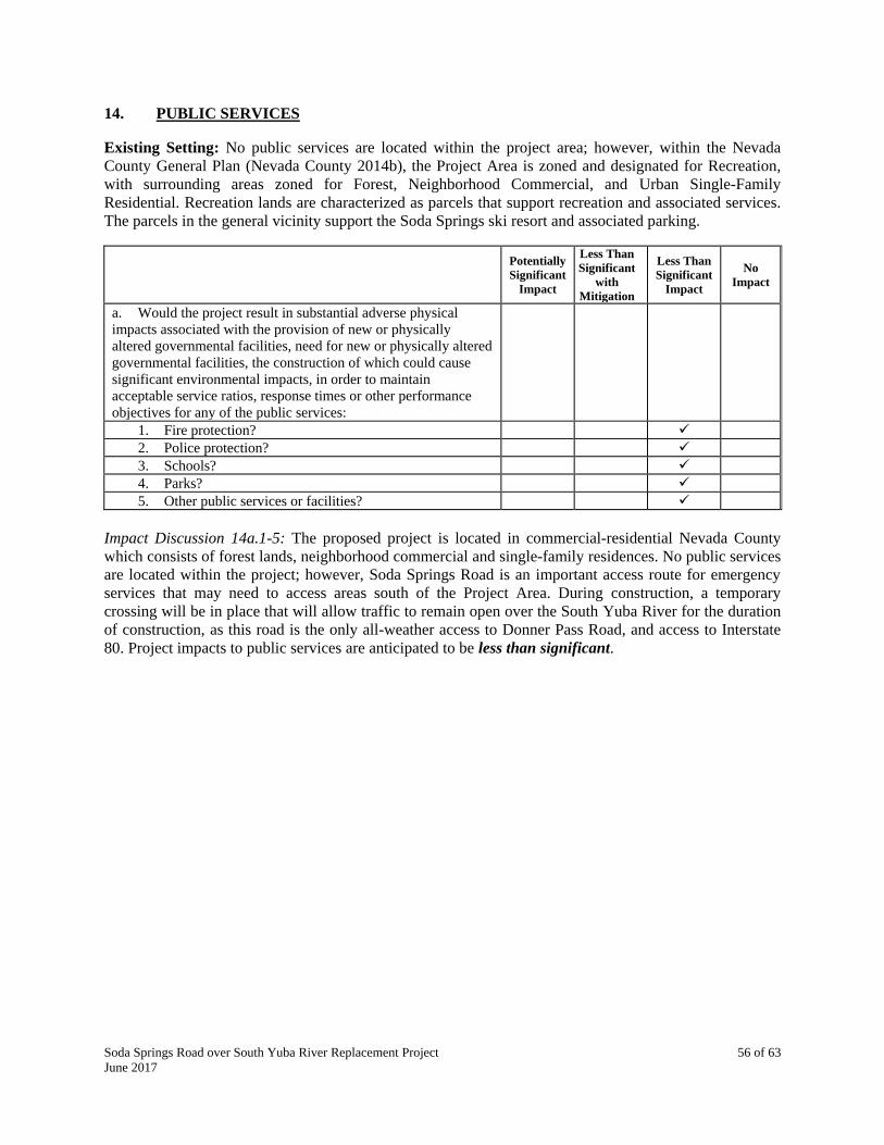
Soda Springs Road over South Yuba River Replacement Project 56 of 63
June 2017
14. PUBLIC SERVICES Existing Setting: No public services are located within the project area; however, within the Nevada
County General Plan (Nevada County 2014b), the Project Area is zoned and designated for Recreation,
with surrounding areas zoned for Forest, Neighborhood Commercial, and Urban Single-Family
Residential. Recreation lands are characterized as parcels that support recreation and associated services.
The parcels in the general vicinity support the Soda Springs ski resort and associated parking.
Potentially
Significant
Impact
Less Than
Significant
with
Mitigation
Less Than
Significant
Impact
No
Impact
a. Would the project result in substantial adverse physical
impacts associated with the provision of new or physically
altered governmental facilities, need for new or physically altered
governmental facilities, the construction of which could cause
significant environmental impacts, in order to maintain
acceptable service ratios, response times or other performance
objectives for any of the public services:
1. Fire protection?
2. Police protection?
3. Schools?
4. Parks?
5. Other public services or facilities?
Impact Discussion 14a.1-5: The proposed project is located in commercial-residential Nevada County
which consists of forest lands, neighborhood commercial and single-family residences. No public services
are located within the project; however, Soda Springs Road is an important access route for emergency
services that may need to access areas south of the Project Area. During construction, a temporary
crossing will be in place that will allow traffic to remain open over the South Yuba River for the duration
of construction, as this road is the only all-weather access to Donner Pass Road, and access to Interstate
80. Project impacts to public services are anticipated to be less than significant.
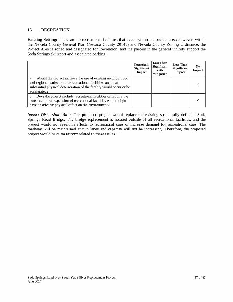
Soda Springs Road over South Yuba River Replacement Project 57 of 63
June 2017
15. RECREATION
Existing Setting: There are no recreational facilities that occur within the project area; however, within
the Nevada County General Plan (Nevada County 2014b) and Nevada County Zoning Ordinance, the
Project Area is zoned and designated for Recreation, and the parcels in the general vicinity support the
Soda Springs ski resort and associated parking.
Potentially
Significant
Impact
Less Than
Significant
with
Mitigation
Less Than
Significant
Impact
No
Impact
a. Would the project increase the use of existing neighborhood
and regional parks or other recreational facilities such that
substantial physical deterioration of the facility would occur or be
accelerated?
b. Does the project include recreational facilities or require the
construction or expansion of recreational facilities which might
have an adverse physical effect on the environment?
Impact Discussion 15a-c: The proposed project would replace the existing structurally deficient Soda
Springs Road Bridge. The bridge replacement is located outside of all recreational facilities, and the
project would not result in effects to recreational uses or increase demand for recreational uses. The
roadway will be maintained at two lanes and capacity will not be increasing. Therefore, the proposed
project would have no impact related to these issues.

Soda Springs Road over South Yuba River Replacement Project 58 of 63
June 2017
16. TRANSPORTATION / CIRCULATION
Existing Setting: The project is located on Soda Springs Road, 750 feet south of the intersection of
Donner Pass Road and Soda Springs Road. The Soda Springs Road Bridge is the only all-weather access
to the Serene Lakes residential community, and Soda Springs Ski Resort. No public transportation occurs
on Soda Springs Road.
Would the project: Potentially
Significant
Impact
Less Than
Significant
with
Mitigation
Less Than
Significant
Impact
No
Impact
a. Conflict with an applicable plan, ordinance or policy
establishing measures of effectiveness for the performance of
the circulation system, taking into account all modes of
transportation including mass transit and non-motorized travel
and relevant components of the circulation system, including but
not limited to intersections, streets, highways and freeways,
pedestrian and bicycle paths, and mass transit?
b. Conflict with an applicable congestion management
program, including, but not limited to level of service standards
and travel demand measures, or other standards established by
the county congestion management agency for designated roads
or highways?
c. Result in a change in air traffic patterns, including either an
increase in traffic levels or a change in location that results in
substantial safety risks?
d. Substantially increase hazards due to a design feature (e.g.,
sharp curves or dangerous intersections) or incompatible uses
(e.g., farm equipment)?
e. Result in inadequate emergency access?
f. Conflict with adopted policies, plans, or programs
regarding public transit, bicycle, or pedestrian facilities, or
otherwise decrease the performance or safety of such facilities?
Impact Discussion 16a-c: The proposed bridge widening will replace the existing structurally deficient
Soda Springs Road Bridge with a single span, approximately 44-foot long by 40-foot wide, cast-in-place
reinforced concrete slab bridge The bridge will accommodate two 12-foot lanes, two 3-foot shoulders, a
6-foot sidewalk, and bridge railings at each edge of deck. The roadway will be maintained at two travel
lanes. At least one lane of Soda Springs Road will remain open during construction, as this road is the
only all-weather access to the Serene Lakes residential community. A temporary detour constructed on
temporary embankment across the river just upstream of the bridge is anticipated to accommodate traffic
during bridge construction. Traffic control as stated as in AQ- 2 will help reduce any traffic issues during
construction. All roadway and structure improvements are anticipated to fall within existing right-of-way.
Soda Springs Road is currently a County maintained road access for residences and will continue after
construction. This project will have no impact on increased traffic and public or private road
maintenance.
Impact Discussion 16b: Soda Springs Road is designated as a minor collector roadway in the County’s
General Plan. The road serves local residents living along Soda Springs Road and its feeder streets, and is
not subject to a congestion management plan. In addition, the Project will not alter the number of through
lanes on the roadway and will have no impact on long term traffic demand.
Impact Discussion 16c: The Project is related to a local roadway and will have no impact on air traffic
patterns.

Soda Springs Road over South Yuba River Replacement Project 59 of 63
June 2017
Impact Discussion 16d: The new bridge will be approximately 12 feet wider than the existing bridge
structure and will be in approximately the same alignment. The Project Area does not contact significant
sharp curves or dangerous intersection and the proposed project will no increase hazards along Soda
Springs Road. No impact to hazardous design features will occur.
Impact Discussion 16e: The Project will replace the existing bridge with a wider structure in
approximately the same alignment. No long term or operational impacts to emergency access will occur.
Soda Springs Road will remain open during construction, as this road is the only all-weather access from
Donner Pass Road to many properties. At least one lane of Soda Springs Road will remain open during
construction, as this road is the only all-weather access to the Serene Lakes residential community. A
temporary detour constructed on temporary embankment across the river just upstream of the bridge is
anticipated to accommodate traffic during bridge construction. Emergency access may be slightly
impaired during construction if the speed limit of the temporary creek crossing is lower than the design
speed of Soda Springs Road. Any impediments will be temporary, minor and have a less than significant
impact on emergency access.
Impact Discussion 16f: There are no mass transit routes along Soda Springs Road and the Project Area is
not included in the County’s Bicycle Master Plan (Nevada County 2007). Pedestrians and cyclists utilize
the existing bridge, which does not have sidewalks or bike lanes. The replacement bridge will be
construct 3-foot shoulders and 6-foot sidewalk with bridge railings along each edge of deck, which will
increase pedestrian and bicycle safety by allowing motor vehicles to pass pedestrians and bicyclists
safely. The new sidewalk and should will accommodate the connection of the Van Norden History Trail
around Lake Van Norden and other bicycle and multi-use trails with proximity to the project. No impact
to bicycle or pedestrian safety is anticipated.
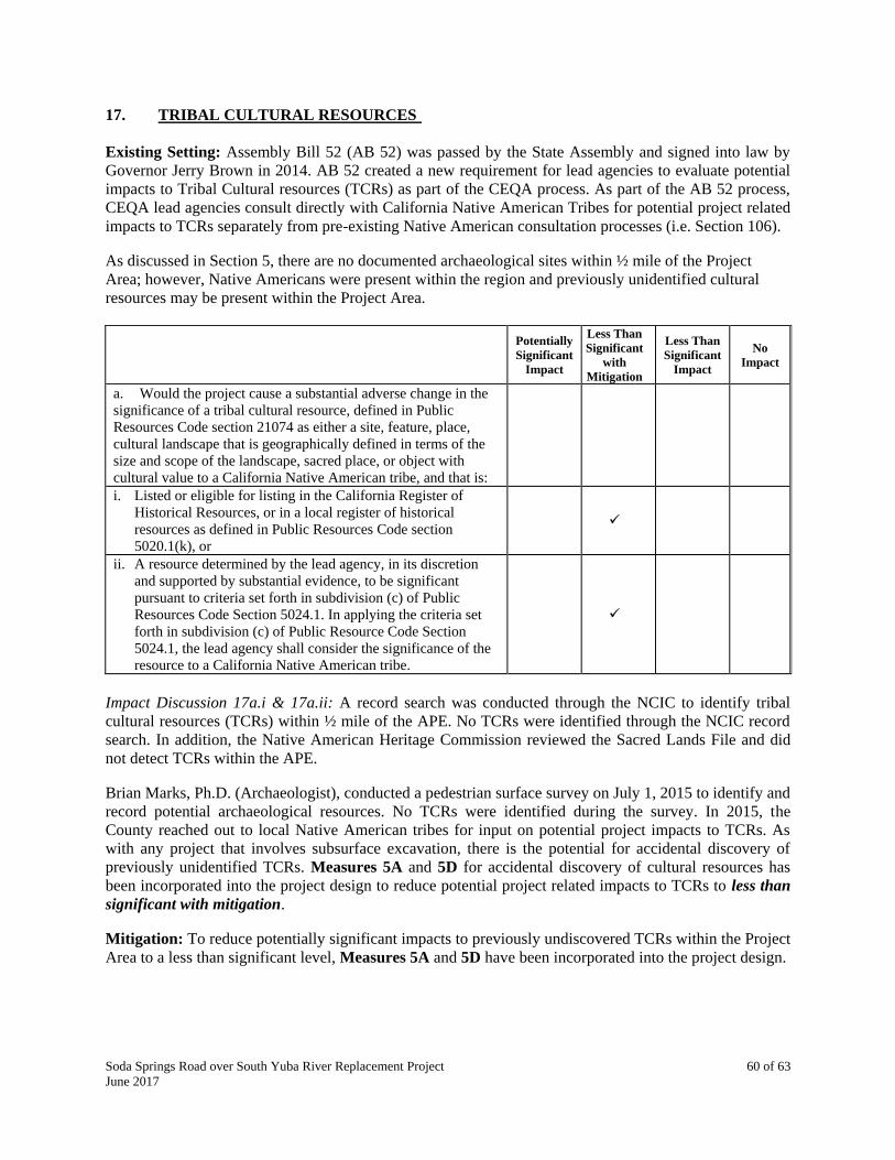
Soda Springs Road over South Yuba River Replacement Project 60 of 63
June 2017
17. TRIBAL CULTURAL RESOURCES
Existing Setting: Assembly Bill 52 (AB 52) was passed by the State Assembly and signed into law by
Governor Jerry Brown in 2014. AB 52 created a new requirement for lead agencies to evaluate potential
impacts to Tribal Cultural resources (TCRs) as part of the CEQA process. As part of the AB 52 process,
CEQA lead agencies consult directly with California Native American Tribes for potential project related
impacts to TCRs separately from pre-existing Native American consultation processes (i.e. Section 106).
As discussed in Section 5, there are no documented archaeological sites within ½ mile of the Project
Area; however, Native Americans were present within the region and previously unidentified cultural
resources may be present within the Project Area.
Potentially
Significant
Impact
Less Than
Significant
with
Mitigation
Less Than
Significant
Impact
No
Impact
a. Would the project cause a substantial adverse change in the
significance of a tribal cultural resource, defined in Public
Resources Code section 21074 as either a site, feature, place,
cultural landscape that is geographically defined in terms of the
size and scope of the landscape, sacred place, or object with
cultural value to a California Native American tribe, and that is:
i. Listed or eligible for listing in the California Register of
Historical Resources, or in a local register of historical
resources as defined in Public Resources Code section
5020.1(k), or
ii. A resource determined by the lead agency, in its discretion
and supported by substantial evidence, to be significant
pursuant to criteria set forth in subdivision (c) of Public
Resources Code Section 5024.1. In applying the criteria set
forth in subdivision (c) of Public Resource Code Section
5024.1, the lead agency shall consider the significance of the
resource to a California Native American tribe.
Impact Discussion 17a.i & 17a.ii: A record search was conducted through the NCIC to identify tribal
cultural resources (TCRs) within ½ mile of the APE. No TCRs were identified through the NCIC record
search. In addition, the Native American Heritage Commission reviewed the Sacred Lands File and did
not detect TCRs within the APE.
Brian Marks, Ph.D. (Archaeologist), conducted a pedestrian surface survey on July 1, 2015 to identify and
record potential archaeological resources. No TCRs were identified during the survey. In 2015, the
County reached out to local Native American tribes for input on potential project impacts to TCRs. As
with any project that involves subsurface excavation, there is the potential for accidental discovery of
previously unidentified TCRs. Measures 5A and 5D for accidental discovery of cultural resources has
been incorporated into the project design to reduce potential project related impacts to TCRs to less than
significant with mitigation.
Mitigation: To reduce potentially significant impacts to previously undiscovered TCRs within the Project
Area to a less than significant level, Measures 5A and 5D have been incorporated into the project design.

Soda Springs Road over South Yuba River Replacement Project 61 of 63
June 2017
18. UTILITIES / SERVICE SYSTEMS
Existing Setting: No utilities or service systems are located within the project.
Would the project: Potentially
Significant
Impact
Less Than
Significant
with
Mitigation
Less Than
Significant
Impact
No
Impact
a. Exceed wastewater treatment requirements of the applicable
Regional Water Quality Control Board?
b. Require or result in the construction of new water or
wastewater treatment facilities or expansion of existing facilities,
the construction of which could cause significant environmental
effects?
c. Require or result in the construction of new storm water
drainage facilities or expansion of existing facilities, the
construction of which could cause significant environmental
effects?
d. Have sufficient water supplies available to serve the project
from existing entitlements and resources, or are new or expanded
entitlements needed?
e. Result in a determination by the wastewater treatment
provider which serves or may serve the project that it has
adequate capacity to serve the project’s projected demand in
addition to the provider’s existing commitments?
f. Be served by a landfill with sufficient permitted capacity to
accommodate the project’s solid waste disposal needs?
g. Comply with federal, state, and local statutes and regulations
related to solid waste?
Impact Discussion 18a-g: As a non-capacity increasing transportation project, the project would not
promote future growth or require expansion of services. In addition, no sewer or septic facilities are
present within the Project Area. Construction of the Project would not generate substantial solid waste
during operation. Bridge demolition would generate concrete debris; however, the amount generated
would not exceed landfill intake capabilities at the Tahoe Truckee Sierra Disposal, Eastern Regional
Landfill Materials Recovery Facility and Transfer Station, located at 900 Cabin Creek Road on State
Highway 89. Additionally, the project will comply with all federal, state, local statutes and regulation
related to solid waste. Therefore, the project would have no impact related to utilities or public service
systems.

Soda Springs Road over South Yuba River Replacement Project 62 of 63
June 2017
19. MANDATORY FINDINGS OF SIGNIFICANT ENVIRONMENTAL EFFECT
Potentially
Significant
Impact
Less Than
Significant
with
Mitigation
Less Than
Significant
Impact
No
Impact
a. Does the project have the potential to degrade the quality of
the environment, substantially reduce the habitat of a fish or
wildlife species, cause a fish or wildlife population to drop below
self-sustaining levels, threaten to eliminate a plant or animal
community, reduce the number or restrict the range of a rare or
endangered plant or animal, or eliminate important examples of
major periods of California's history or prehistory?
b. Does the project have environmental effects that are
individually limited but cumulatively considerable?
(“Cumulatively considerable” means that the incremental effects
of the project are considered when viewed in connection with the
effects of past, current, and probable future projects.)
c. Does the project have environmental effects, which will
cause substantial adverse effects on human beings, either directly
or indirectly?
Impact Discussion 19a: Development of the proposed project would comply with all local, state, and
federal laws governing general welfare and environmental protection. The project will not substantially
reduce habitat for fish or wildlife, cause wildlife populations to decrease, threaten plant and animal
communities, restrict plant and animals range, or eliminate important examples of California’s history or
prehistory. During construction, the project has the potential for significant impacts to biological and
cultural resources. With the implementation of Measures 4A, 4B, 5A, 5D, 8B, and 9A these potential
project impacts will be reduced to a less than significant level. The project would have impacts of less
than significant with mitigation related to biological and cultural resources.
Impact Discussion 19b: The proposed project is not growth inducing; thus, it would not contribute to the
cumulative effects of population growth. Potentially significant impacts to air quality, biological
resources, cultural and tribal resources, geology and soils, hazards and hazardous materials,
hydrology/water quality, and noise would be reduced to less than significant levels by adhering to local,
regional, state, and federal impact standards and by the adherence to the project-specific mitigation
measures outlined in this Initial Study. However, the project will have an individually limited but
cumulatively considerable effect on hydrology when considering the future impacts of the Van Norden
Dam Modification Project. Results of Bridge Design Hydraulic Study Report (2016) found that the Soda
Springs Road Bridge Replacement Project will meet Caltrans standard freeboard for both current and dam
removal scenarios, and would reduce water surface elevations upstream of the bridge by 2 feet.
Hydrology impacts and flood risk would not be increased by the bridge replacement when cumulatively
considered with the Van Norden Dam Modification Project. Collectively, these potentially negative
impacts would be less than significant, and no additional mitigation is required.
Impact Discussion 19c: The proposed project would comply with all local, state, and federal laws
governing general welfare and environmental protection. Project implementation would not substantially
degrade the quality of the existing environment, since the proposed project is a replacement of an existing
structure and would not result in any significant adverse and un-mitigatable impacts that could cause
adverse effects to humans. Therefore, project impacts on human beings would be less than significant,
and no additional mitigation is required.


APPENDIX A – REFERENCE SOURCES
ASR 2016. Archaeological Survey Report for Soda Springs Road Bridge Replacement Project.
Bradford, D.F. 1984. Temperature modulation in a high elevation amphibian, Rana muscosa. (accessed
09/12/16).
California Herps. 2016. Southern Long-toed Salamander-Ambystoma macrodactylum sigillatum.
Available at: <http://www.californiaherps.com/salamanders/pages/a.m.sigillatum.html> (accessed
09/12/16).
CDFW 2016a. CWHR Life History Accounts and Range Maps. Available at:
<http://www.dfg.ca.gov/biogeodata/cwhr/cawildlife.aspx> (accessed 09/13/16).
CDFW 2016b. The California Wildlife Habitat Relationship Classification Scheme. Available at:
<http://www.dfg.ca.gov/biogeodata/cwhr/wildlife_habitats.asp#Tree> (accessed 03/03/16).
CEPA 2009. California Environmental Protection Agency. Air Resources Board-California Ambient Air
Quality Standards (CAAQS). Available at: <http://www.arb.ca.gov/research/aaqs/caaqs/caaqs.htm>
(accessed 09/26/16).
CGS 2015. California Geologic Survey. Alquist-Priolo Fault Zone and Sesimic Hazard Zone Map.
<Available at: http://www.conservation.ca.gov/cgs/rghm/ap> (accessed 02/24/17).
CNDDB 2016. California Natural Diversity Database, Rarefind 5. Available at:
<http://www.dfg.ca.gov/biogeodata/cnddb/> (accessed on 03/03/16).
CNPS 2016. Inventory of Rare and Endangered Plants (online edition, v8-02). California Native Plant
Society, Sacramento, CA. Available at: <http://cnps.site.aplus.net/cgi-
bin/inv/inventory.cgi/BrowseAZ?name=quad> (accessed 03/03/16).
DOC 2000. Department of Conservation – Division of Mines and Geology. A General Location Guide for
Ultramafic Rocks in California – Areas More Likely to Contain Naturally Occurring Asbestos. Available
at: <ftp://ftp.consrv.ca.gov/pub/dmg/pubs/ofr/ofr_2000-019.pdf> (accessed 09/26/16).
DOC 2010. Fault Activity Map of California (2010). Available at:
http://maps.conservation.ca.gov/cgs/fam/#skip-to-content. (accessed 2/24/17).
DOC 2015. Department of Conservation. Important Farmland Categories. Available at:
<http://www.conservation.ca.gov/dlrp/fmmp/mccu/Pages/map_categories.aspx> (accessed on 09/26/16).
DTSC 2017. Department of Toxic Substances Control, Hazardous Waste and Substances Site List
Available at: <http://www.dtsc.ca.gov/SiteCleanup/Cortese_List.cfm/> (accessed 02/24/17).
ECORP. 2015. Sierra Nevada Yellow-Legged Frog Survey Results and Habitat Assessment for the Soda
Springs Bridge Replacement Project.
EPA. 2016. EnviroAtlas. Available at:
https://enviroatlas.epa.gov/enviroatlas/InteractiveMapEntrance/InteractiveMap/index.html (accessed
10/18/16).
FEMA 2015. Federal Emergency Management Agency. Available at: <http://www.fema.gov/> (accessed
09/16/16).

FHWA 2011. Federal Highways Administration. Roadway Construction Noise Model –RCNM. Available
at: <http://www.fhwa.dot.gov/environment/noise/construction_noise/rcnm/> (accessed 09/27/16).
HPSR 2016. Historic Property Survey Report for the Soda Springs Road over South Yuba River Bridge
Replacement Project.
ISA 2016. Initial Site Assessment for the Soda Springs Road over South Yuba River Bridge Replacement
Project.
NES 2017. Natural Environment Study for the Soda Springs Road over South Yuba River Bridge
Replacement Project.
Nevada County 2017. Nevada County My Neighborhood Interactive Map. Available at:
https://gis.nevcounty.net/myneighborhood/ (Accessed 01/26/17).
Nevada County 2015. Nevada County Solid Waste Division. Available at:
<http://www.mynevadacounty.com/nc/cda/pw/sw/Pages/Home.aspx> (accessed 09/26/16).
Nevada County 2014a. Nevada County General Plan. 1996 drafted and amended in 2014. Available at:
<http://www.mynevadacounty.com/nc/cda/planning/Pages/Nevada-County-General-Plan.aspx> (accessed
09/26/16).
Nevada County 2014b. Eastern Nevada County District Zoning Map. Available at:
<https://www.mynevadacounty.com/nc/igs/gis/Pages/Zoning.aspx> (accessed 09/26/16).
Nevada County 2012. Nevada County Interactive Map Gallery. Available at:
<http://www.mynevadacounty.com/nc/igs/gis/Pages/NCMapGallery.aspx> (accessed 09/26/16).
Nevada County 1991. Nevada County General Plan Master Environmental Inventory. Available at:
<https://www.mynevadacounty.com/nc/cda/planning/Pages/Nevada-County-General-Plan.aspx>
(accessed on 09/26/16).
NMFS. 2016. California Species List Tools. Available at:
<http://www.westcoast.fisheries.noaa.gov/maps_data/california_species_list_tools.html> (accessed
10/18/16).
NOAA. 2016. NOAA Habitat Conservation NMFS Essential Fish Habitats Mapper. Available at:
<http://www.habitat.noaa.gov/protection/efh/efhmapper/index.html> (accessed 08/26/2106).
NRCS. 2016. Natural Resource Conservation Service Web Soil Survey. Available at:
<http://websoilsurvey.sc.egov.usda.gov/App/WebSoilSurvey.aspx> (accessed 03/02/16).
USACE. 2008. Regional Supplement to the Corps of Engineers Wetland Delineation Manual: Arid West
Region (Version 2.0). Available at:
<http://www.usace.army.mil/Portals/2/docs/civilworks/regulatory/reg_supp/trel08-28.pdf> (accessed
03/03/16).
NSAQMD 2016. Northern Sierra Air Quality Management District. Available at:
<http://myairdistrict.com/index.php?Itemid=70> (accessed 09/26/16).
SMAQMD 2016. Sacramento Metropolitan Air Quality Management District-Road Construction
Emissions Model, Version 8.1.0. Available at: <http://www.airquality.org/residents/ceqa-land-use-
planning/ceqa-guidance-tools> (accessed 09/26/16).

Stebbins, R. C. (2003). Western Reptiles and Amphibians, Third Edition. Houghton Mifflin, Boston.
SWRCB 2016. Central Valley Regional Water Quality Control Board. Available at:
<http://www.swrcb.ca.gov/rwqcb5/> (accessed 9/13/16).
USACE. 1987. Corps of Engineers Wetland Delineation Manual, Technical Report Y-87-1. Available at:
<http://el.erdc.usace.army.mil/elpubs/pdf/wlman87.pdf> (accessed 03/03/16).
U.S. Census 2014. American FactFinder for Nevada County, California. Available at:
<http://factfinder.census.gov/faces/nav/jsf/pages/community_facts.xhtml> (accessed 09/13/16).
usclimatedata.com. 2016. U.S. climate data. Available at: <http://usclimatedata.com/climate/grass-
valley/california/united-states/usca0437> (accessed 03/04/16).
USFS, 2014. Sierra Nevada Forest Plan Implementation. Available at:
http://www.placer.ca.gov/~/media/cdr/ECS/EIR/VSVSP/references/04%20land%20us/USFS%202014_W
ebsite.pdf (accessed 12/30/16).
USFWS. 2016a. U.S. Fish & Wildlife Service Critical Habitat Portal. Available at:
<http://ecos.fws.gov/crithab/> (accessed 08/25/16).
USFWS. 2016b. U.S. Fish & Wildlife Service Critical Habitat Mapper. Available at:
<http://fws.maps.arcgis.com/home/webmap/viewer.html?webmap=9d8de5e265ad4fe09893cf75b8dbfb77
> (accessed 08/25/16).
USFWS. 2016c. U.S. Fish & Wildlife Service. Federal Register Vol. 81, No. 166. 50 CFR Part 17.
Endangered and Threatened Wildlife and Plant; Designation of Critical Habitat for the Sierra Nevada
Yellow- legged frog, the Northern DPS of the Mountain Yellow-legged frog, and the Yosemite Toad
Final Rule. Available at: <https://ecos.fws.gov/ecp0/profile/speciesProfile?spcode=D04M> (accessed
11/7/16).
USFWS. 2015. Species Report. Sierra Nevada Red Fox (Vulpes vulpes necator). Available at:
<https://www.fws.gov/sacramento/outreach/2015/10-07/docs/20150814_SNRF_SpeciesReport.pdf>
(accessed 10/12/16).
USFWS. 2014. Programmatic Biological Opinion on Nine Forest Programs on Nine National Forests in
the Sierra Nevada of California for the Endangered Sierra Nevada Yellow-legged Frog, Endangered
Northern Distinct Population Segment of the Mountain Yellow-legged Frog and Threatened Yosemite
Toad. (accessed 11/7/16).
USFWS. 2013. Designation of Critical Habitat for the Sierra Nevada Yellow-Legged Frog, the Northern
Distinct Population Segment of the Mountain Yellow-Legged Frog, and the Yosemite Toad; Proposed
Rule. 78 FR 24515 24574. Available at: <https://www.gpo.gov/fdsys/pkg/FR-2013-04-25/pdf/2013-
09598.pdf> (accessed 01/23/17).
USFWS. 2007. National Bald Eagle Management Guidelines. Available at:
<https://www.fws.gov/southdakotafieldoffice/NationalBaldEagleManagementGuidelines.pdf> (accessed
11/10/16).
USFWS. 1995. Recovery Plan for the Lahontan Cutthroat Trout. USFWS Region 1, Portland, Oregon.
Available at: <http://ecos.fws.gov/docs/recovery_plan/950130.pdf> (accessed 10/12/16).
USGS 2011. Reported Historic Asbestos Mines, Historic Asbestos Prospects, and Other Natural

Occurrences of Asbestos in California. Available at:
<ftp://ftp.consrv.ca.gov/pub/dmg/pubs/ms/59/MS59_Plate.pdf > (accessed 09/26/16).
Wang, J. C. S. 2010. Fishes of the Sacramento–San Joaquin Estuary and Adjacent Waters, California: A
Guide to the Early Life Histories. Technical Report #9. Interagency Ecological Study Program for the
Sacramento–San Joaquin Estuary. Available at:
<https://www.usbr.gov/mp/TFFIP/tracyreports/Tech%20Report%209r.pdf> (accessed 5/21/16).
Zeiner 1988-1990. Zeiner, D.C., W.F.Laudenslayer, Jr., K.E. Mayer, and M. White, eds. 1988-1990.
California's Wildlife. Vol. I-III. CDFG, Sacramento, California.


APPENDIX B – ACRONYMS
AB 52 Assembly Bill 52
ADL Aerially Deposited Lead
APE Area of Potential Effects
ARB California Air Resources Board
ASR Archeological Survey Report
BMPs Best Management Practices
BSA Biological Study Area
CAAQS California Ambient Air Quality Standards
Cal-IPC California Invasive Plant Council
Caltrans California Department of Transportation
CESA California Endangered Species Act
CEQA California Environmental Quality Act
CH4 Methane
CO2 Carbon dioxide
dBA Weighted decibel
DOC California Department of Conservation
DTSC Department of Toxic Substance Control
EDR Environmental Data Resources, Inc.
EIR Environmental Impact Report
ESA Environmentally Sensitive Area
FEMA Federal Emergency Management Agency
FESA Federal Endangered Species Act
FIRM Flood Insurance Rate Map
GHG Greenhouse Gases
HFCs Hydrofluorocarbons
HPSR Historic Property Survey Report
LUST Leaking Underground Storage Tank
mph Mile per hour
NAAQS National Ambient Air Quality Standards
NES Natural Environmental Study
NO2 Nitrogen oxide
NPDES National Pollutant Discharge Elimination System
NSAQMD Northern Sierra Air Quality Management District
PCEs Primary Constituent Elements
PFC Perfluorocarbons
PM (2.5 and 10) Particulate matter
REC Recognized Environmental Condition
SF6 Sulfur hexafluoride
SNYLF Sierra Nevada Yellow-Legged Frog
SWPPP Storm Water Pollution Prevention Plan
SWRCB State Water Resources Control Board
VOC Volatile organic compounds
USACE United States Army Corps of Engineers
USFWS United States Fish and Wildlife Service


APPENDIX C – FTIP and RTP PAGES


APPENDIX D – SPECIAL STATUS SPECIES POTENTIAL TABLE


Chapter 3 Results: Environmental Setting
Soda Springs Road over Soda Springs Road Bridge Replacement- Natural Environment Study 20 2017
Table 3: Special Status Species with Potential to Occur in the Project Vicinity
Common Name Scientific Name Status General Habitat Description
Habitat
Present/
Absent
Potential for Occurrence and Rationale
Amphibian Species
Sierra Nevada
yellow-legged frog Rana sierrae
Fed:
State:
CDFW:
E
T
SSC
The species exists in montane regions of Sierra Nevada, historically inhabiting lakes, ponds, marshes, meadows and streams at elevations ranging from 4,500 – 12,000 feet. The species is highly aquatic and rarely found more than 4 feet from water. At lower elevations the species is associated with rocky streambeds and mesic meadows within coniferous forests.
HP
Low to Moderate Potential: Habitat
Assessments conducted June 2015
determined marginally suitable high elevation
stream channel and montane riparian is
present within the BSA. The site was
determined to contain only marginal habitat
for the species based on lack of exposed
banks, basking sites, unsuitable volume and
velocity of water, and the site’s proximity to
urban infrastructure. In addition, the BSA is
located within designated Critical Habitat and
there are numerous occurrences of the
species within 5 miles of the project area.
However, the nearest occurrences with 2
miles are historic occurrences (dating back
approximately 60 to 80 years). The nearest
known recent population is approximately 3.5
miles north of the project and is located over
the Sand Ridge (beyond Andesite Peak).
There is no hydric connectivity to the BSA to
any recent SNYLF occurrences.
Southern long toed
salamander
Ambystoma
macrodactylum
sigillatum
Fed:
State:
CDFW:
--
--
SSC
Species predominately live under wood, logs, rocks, bark or burrows excavated by ground squirrel and moles in close proximity to breeding sites (ponds, lakes and streams). Breeding requires permanent or temporary ponds, lakes and flooded meadows.
HP
Low to Moderate Potential: The South
Yuba River and a wet meadow habitat are
present within the BSA, which can act as
suitable breeding habitat for the species.
Lake Van Norden, approximately 300 feet
upstream of the BSA, is suitable habitat for
the species as well. Nearest CNDDB
occurrence is approximately 2.7 miles east of

Chapter 3 Results: Environmental Setting
Soda Springs Road over Soda Springs Road Bridge Replacement- Natural Environment Study 21 2017
the project area near Donner Pass (2005).
Bird Species
Bald eagle Haliaeetus
leucocephalus
Fed:
State:
CDFW:
DL
E
FP
Species occurs near ocean shores, lakes, rivers, rangelands and coastal wetlands for nesting and wintering. Nesting occurs within 1 mile of a water source with abundant fish near mountain forests and woodlands. Species prefers ponderosa pines for nesting.
A
Presumed Absent: No suitable nesting
habitat or foraging habitat occurs within the
BSA. However, Lake Van Norden which lies
approximately 300 feet upstream of the BSA
may provide suitable foraging habitat and
established lodgepole pines, Jeffery pines
and white firs adjacent to the BSA may
provide suitable roosting habitat for bald
eagle. No current or historic nests were
observed within the BSA or the immediate
vicinity. The nearest occurrence of the
species has been recorded along Lake Van
Norden (ebird 2016). The nearest CNDDB
occurrence is approximately 6.3 miles east of
the project area near Donner Lake.
Black swift Cypseloides
niger
Fed:
State:
CDFW:
--
--
SSC
Returns to California in May where the species breeds locally in the San Gabriel Mountains from June through August. Nests in small colonies within moist crevices or caves on sea cliffs over the surf, or within cliffs of deep canyons behind or immediately adjacent to waterfalls; species very specific with requisite nesting conditions. Species forages over many habitats and may undergo long distance foraging flights.
A
Presumed Absent: The BSA does not
contain moist crevices, caves, or waterfall
habitat commonly associated with the
species. A single occurrence of the species
recorded in 1956 was found within the search
quads approximately 1 mile from the BSA
along the east shore of Lake Van Norden.
The species is not common in the Sierra
Nevada.
Greater sandhill
crane
Grus canadensis
tabida
Fed:
State:
CDFW:
--
T
FP
The species nests and forages in mesic meadows, bogs, fens, marshes, and grasslands. Prefers grain fields and irrigated pastures within 4 miles of a shallow body of water. It California, the species is a winter resident in the Honey Lake Basin, Imperial Valley, and parts of the Sacramento Valley.
A
Presumed Absent: The BSA is
predominately disturbed land lacking any
suitable nesting or foraging habitat for the
species. The nearest occurrence of the
species is approximately 11 miles from the
BSA within Sierra County. No local
occurrences of the species have been
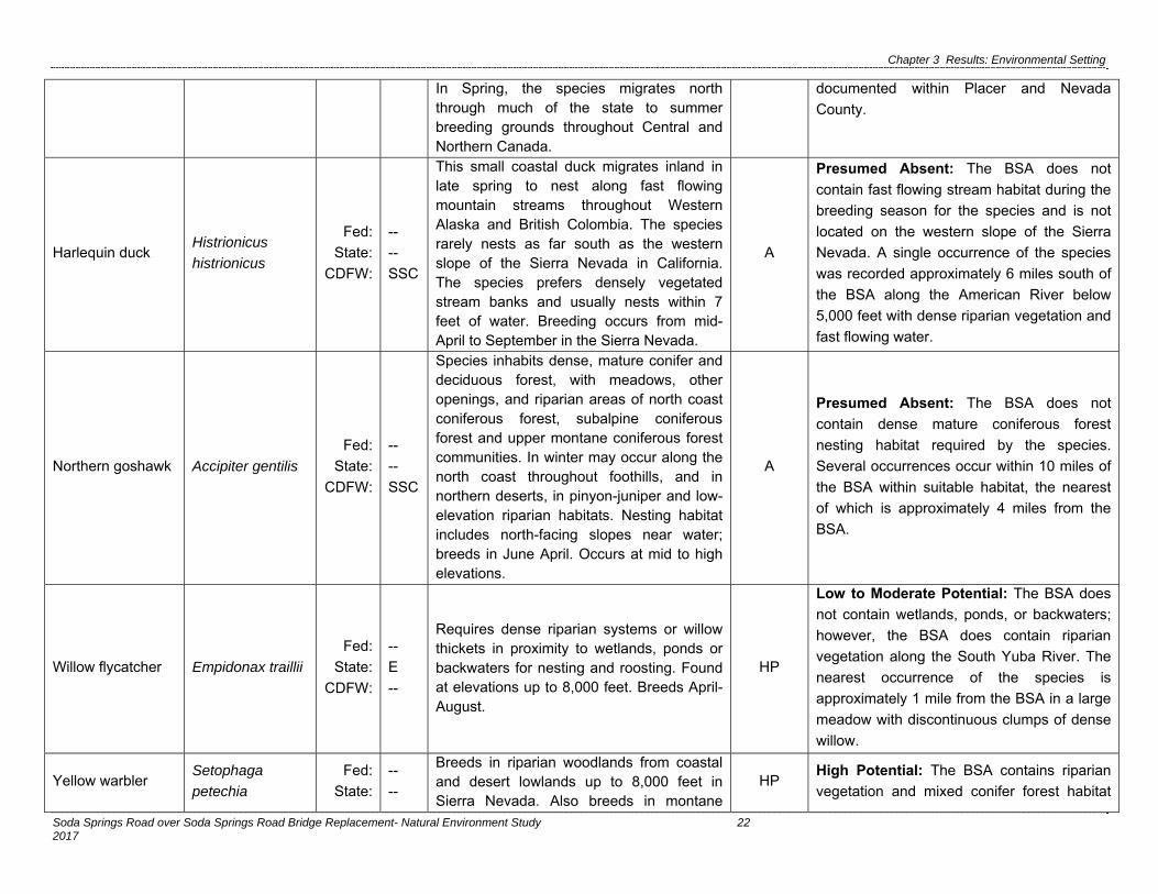
Chapter 3 Results: Environmental Setting
Soda Springs Road over Soda Springs Road Bridge Replacement- Natural Environment Study 22 2017
In Spring, the species migrates north through much of the state to summer breeding grounds throughout Central and Northern Canada.
documented within Placer and Nevada
County.
Harlequin duck Histrionicus
histrionicus
Fed:
State:
CDFW:
--
--
SSC
This small coastal duck migrates inland in late spring to nest along fast flowing mountain streams throughout Western Alaska and British Colombia. The species rarely nests as far south as the western slope of the Sierra Nevada in California. The species prefers densely vegetated stream banks and usually nests within 7 feet of water. Breeding occurs from mid-April to September in the Sierra Nevada.
A
Presumed Absent: The BSA does not
contain fast flowing stream habitat during the
breeding season for the species and is not
located on the western slope of the Sierra
Nevada. A single occurrence of the species
was recorded approximately 6 miles south of
the BSA along the American River below
5,000 feet with dense riparian vegetation and
fast flowing water.
Northern goshawk Accipiter gentilis
Fed:
State:
CDFW:
--
--
SSC
Species inhabits dense, mature conifer and deciduous forest, with meadows, other openings, and riparian areas of north coast coniferous forest, subalpine coniferous forest and upper montane coniferous forest communities. In winter may occur along the north coast throughout foothills, and in northern deserts, in pinyon-juniper and low-elevation riparian habitats. Nesting habitat includes north-facing slopes near water; breeds in June April. Occurs at mid to high elevations.
A
Presumed Absent: The BSA does not
contain dense mature coniferous forest
nesting habitat required by the species.
Several occurrences occur within 10 miles of
the BSA within suitable habitat, the nearest
of which is approximately 4 miles from the
BSA.
Willow flycatcher Empidonax traillii
Fed:
State:
CDFW:
--
E
--
Requires dense riparian systems or willow thickets in proximity to wetlands, ponds or backwaters for nesting and roosting. Found at elevations up to 8,000 feet. Breeds April-August.
HP
Low to Moderate Potential: The BSA does
not contain wetlands, ponds, or backwaters;
however, the BSA does contain riparian
vegetation along the South Yuba River. The
nearest occurrence of the species is
approximately 1 mile from the BSA in a large
meadow with discontinuous clumps of dense
willow.
Yellow warbler Setophaga
petechia
Fed:
State:
--
--
Breeds in riparian woodlands from coastal and desert lowlands up to 8,000 feet in Sierra Nevada. Also breeds in montane
HP High Potential: The BSA contains riparian
vegetation and mixed conifer forest habitat

Chapter 3 Results: Environmental Setting
Soda Springs Road over Soda Springs Road Bridge Replacement- Natural Environment Study 23 2017
CDFW: SSC chaparral, and in open ponderosa pine and mixed conifer habitats with substantial amounts of brush. Breeds from mid-April into early August with peak activity in June, and susceptible to brood parasitism by brown-headed cowbirds
potentially suitable for the species. The
nearest occurrence of the species is
approximately 4 miles from the BSA.
Fish Species
Central Valley
Steelhead
Oncorhynchus
mykiss
Fed:
State:
CDFW:
T
--
--
Spawning occurs in small tributaries on coarse gravel beds in riffle areas. Central Valley steelhead are found in the Sacramento River system; the principal remaining wild populations spawn annually in Deer and Mill Creeks in Tehama County, in the lower Yuba River, a small population in the lower Stanislaus River.
A
Presumed Absent: Multiple impassible
barriers to migrating fish exclude
anadromous fish from the BSA including the
Camp Far West Spillway, Lake Spaulding
Dam, and Englebright Dam. There are no
occurrences of the species within the search
quads.
Chinook Salmon
(Winter-run)
Oncorhynchus
tshawytscha
Fed:
State:
CDFW:
E
--
--
Spawning occurs in rivers and streams with cool, clear, water and suitable substrate. Winter-run Chinook salmon include all naturally spawned populations of winter-run Chinook salmon in the Sacramento River and its tributaries in California, as well as two artificial propagation programs.
A
Presumed Absent: Multiple impassible
barriers to migrating fish exclude
anadromous fish from the BSA, including the
Camp Far West Spillway, Lake Spaulding
Dam, and Englebright Dam. There are no
occurrences of the species within the search
quads.
Delta smelt Hypomesus
transpacificus
Fed:
State:
CDFW:
T
E
--
Occurs within the Sacramento-San Joaquin Delta and seasonally within the Suisun Bay, Carquinez Strait and San Pablo Bay. Most often occurs in partially saline waters.
A
Presumed Absent: Multiple impassible
barriers to migrating fish exclude
anadromous fish from the BSA including the
Camp Far West Spillway, Lake Spaulding
Dam, and Englebright Dam. Additionally, the
project is located outside the Sacramento-
San Joaquin Delta and lacks partially saline
waters. There are no occurrences of the
species within the search quads.

Chapter 3 Results: Environmental Setting
Soda Springs Road over Soda Springs Road Bridge Replacement- Natural Environment Study 24 2017
Lahontan cutthroat
trout
Oncorhynchus
clarkii henshawi
Fed:
State:
CDFW:
T
--
--
This completely land locked salmonid is endemic to the Lahontan Basin in Northern Nevada including Pyramid and Walker Lakes and associated tributaries. Major threats to the species include habitat alteration or destruction and hybridization with introduced non-native species of trout.
A
Presumed Absent: The project is located on
the west side of the Sierra crest and no
surface water connection between surface
waters within the BSA and the Lahontan
basin where the species is endemic.
Mammal Species
American badger Taxidea taxus
Fed:
State:
CDFW:
--
--
SSC
Prefers treeless, dry, open stages of most shrub and herbaceous habitats with friable soils and a supply of rodent prey. Species also inhabits forest glades and meadows, marshes, brushy areas, hot deserts, and mountain meadows. Species maintains burrows within home ranges estimated between 338-1,700 acres, dependent on seasonal activity. Burrows are frequently re-used, but new burrows may be created nightly. Young are born in March and April within burrows dug in relatively dry, often sandy, soil, usually in areas with sparse overstory cover. Species is somewhat tolerant of human activity, but is sensitive to automobile mortality, trapping, and persistent poisons (up to 12,000 feet).
A
Presumed Absent: Large tracks of treeless
shrubby habitat are absent from the BSA and
the surrounding area. Additionally, the BSA
lacks a sufficient rodent prey base to support
the species. No suitable habitat for the
species is present within the BSA. The
nearest occurrence of the species is
approximately 14 miles from the BSA.
California
wolverine
Gulo gulo ssp.
luscus
Fed:
State:
CDFW:
--
T
FP
Wolverines are opportunistic omnivores found in a wide variety of alpine, boreal and arctic habitats throughout North America. The main habitat requirement for the species are caves, logs, burrows and deep persistent snow sufficient for maternal den construction so the species is limited to high elevation alpine habitats within the contiguous United States. The species also requires open areas for hunting and are easily disturbed by human presence.
HP
Presumed Absent: The BSA does contain
potentially suitable alpine habitat and
sufficient snow depth to sustain the species;
however, the BSA is located along a busy
road near Soda Springs ski resort and close
proximity to human residences. Reference
occurrences of the species occur in isolated
locations lacking human presence. The
nearest occurrence of the species is
approximately 1.5 miles from the BSA.

Chapter 3 Results: Environmental Setting
Soda Springs Road over Soda Springs Road Bridge Replacement- Natural Environment Study 25 2017
Fisher - West
Coast DPS Pekania pennanti
Fed:
State:
CDFW:
PT
CT
SSC
Inhabits mature, dense habitats of north coast coniferous forest and old growth and riparian forest communities with a high percent of canopy closure, large trees and snags with cavities and other deformities, large diameter downed wood and multiple canopy layers. Forest structural composition is critical for species; diversity in tree size and shape, light gaps and associated understory vegetation, natural structures (downed trees, broken limbs, snags, etc.) and limbs close to the ground. Breeds from late February to late April (1,970-8530 feet).
A
Presumed Absent: The BSA does not
contain mature dense coniferous forests with
closed multiple layered canopy and snags
with cavities required by the species. The
BSA and adjacent areas have largely been
cleared of large trees to facilitate parking for
the Soda Springs Ski Resort. There are
numerous occurrences of the species within
10 miles of the BSA but all of these are
located far from human development. The
nearest occurrence of the species was
recorded in 1969 and is approximately 6
miles from the BSA.
Sierra Nevada
mountain beaver
Aplodontia rufa
californica
Fed:
State:
CDFW:
--
--
SSC
The species is found in deciduous and coniferous forests, wet soils and seepage areas, and abundance of forbs within the Sierra Nevada, primarily concentrated in the Tahoe/Truckee Region. The species requires dense understory of coyote brush (Baccharis pilularis), sword fern (Polystichum munitum), blackberry (Rubus sp.), and poison oak (Toxicodendrom diversilobum) with succulent plants for food and cover and soft soil for burrowing in sheltered gulches, steep north facing slopes or old dune systems. The species is not related to true beavers but is still generally found in proximity to water due to an inability to concentrate urine. The species does not hibernate and is poor at conserving body heat and is not found in extremely cold climates.
A
Presumed Absent: The project is located
within the Tahoe/Truckee Region where the
species is concentrated. The BSA contains
wet soils and abundance of forbs in proximity
to the South Yuba River; however, the BSA
lacks sheltered gulches, steep north facing
slopes with dense understory of species
required vegetation and soft soils. The
nearest recorded occurrence of the species
is approximately 9 miles from the BSA.
Sierra Nevada red
fox
Vulpes vulpes
necator
Fed:
State:
CDFW:
C
T
--
The species is found within the Sierra Nevada and Southern Cascade Ranges in open coniferous woodlands and meadows near the treeline. Diet consists of small
A
Presumed Absent: No open coniferous
woodland or meadow habitat is found within
the BSA. The majority of the BSA is heavily
disturbed with compacted soils and a lack of

Chapter 3 Results: Environmental Setting
Soda Springs Road over Soda Springs Road Bridge Replacement- Natural Environment Study 26 2017
mammals including mice, ground squirrels, and, gophers. Threats to the species likely include competition with coyotes and disease spread from domestic dogs.
burrowing species required by the species.
No suitable habitat for the species is present
within the BSA. The nearest occurrence of
the species is approximately 5 miles from the
BSA.
Sierra Nevada
snowshoe hare
Lepus
americanus
tahoensis
Fed:
State:
CDFW:
--
--
SSC
The species occurs in high elevation riparian habitats above the yellow pine zone, approximately 7,500 feet. Typical habitat is characterized by dense thickets of deciduous trees and shrubs. Predators include bobcats, red foxes, coyotes, hawks and owls. The primary threat to the species is loss of high elevation riparian habitat.
A
Presumed Absent: The BSA is below the
species’ elevation range. The nearest
occurrence of the species is approximately 8
miles from the BSA. For this reason, the
species is presumed absent.
Plant Species
Alder buckthorn Rhamnus
alnifolia
Fed:
State:
CNPS:
--
--
2B.2
A perennial shrub found within moist areas of red fir forests or lodge pole forest In the High Sierra Nevada. Blooms May – July (3,700 – 6,600 feet).
A
Presumed Absent: The BSA and
surrounding areas have been cleared to
provide parking for the adjacent Soda
Springs Ski Resort and do not contain red fir
or lodge pole forest habitat required for the
species. No suitable habitat for the species is
present within the BSA. The nearest
occurrence of the species is approximately 7
miles from the BSA.
Austin's astragalus Astragalus
austiniae
Fed:
State:
CNPS:
--
--
1B.3
A perennial herb found along exposed ridges and meadows within subalpine forests or above the treeline. Blooms July – September (7,600 – 9,000 feet).
A
Presumed Absent: The BSA does not
contain exposed ridge or alpine ridge habitat
for the species and the BSA is approximately
900 feet below the lower elevation range of
the species. The nearest occurrence of the
species is approximately 2 miles from the
BSA.
Broad-nerved
hump moss Meesia uliginosa
Fed:
State:
CNPS:
--
--
2B.2
A moss found on damp soils within bogs, fens, meadows and seeps within subalpine coniferous forest and upper montane coniferous forest. Reproduces in October
A
Presumed Absent: Although the BSA does
contain meadow habitat required for the
species and is within the species’ elevation

Chapter 3 Results: Environmental Setting
Soda Springs Road over Soda Springs Road Bridge Replacement- Natural Environment Study 27 2017
(4,200 – 9,200 feet). range, no individuals were identified during
the focused botanical survey conducted July,
2015. The nearest occurrence of the species
is approximately 8 miles from the BSA.
Common
moonwort
Botrychium
lunaria
Fed:
State:
CNPS:
--
--
2B.3
A fern found in meadows or wetland margins within coniferous forests in the High Sierra Nevada. Reproduces in August (7,500 – 11,150 feet).
A
Presumed Absent: Although the BSA does
contain meadow required by the species, the
BSA is approximately 900 feet below the
lower elevation range of the species. The
nearest occurrence of the species is
approximately 11 miles from the BSA.
Davy's sedge Carex davyi
Fed:
State:
CNPS:
--
--
1B.3
A perennial herb found in dry often sparse meadows and open slopes within subalpine forest and red fir forest. Blooms May – August (4,600 – 11,000 feet).
A
Presumed Absent: The BSA does not
contain dry meadow or open slope habitat
required by the species. The nearest
occurrence of the species is approximately
10 miles from the BSA.
Donner Pass
buckwheat
Eriogonum
umbellatum var.
torreyanum
Fed:
State:
CNPS:
--
--
1B.2
A perennial herb found in meadows within lodgepole forests and red fir forests on steep slopes and ridgetops with rocky, volcanic soils in the High Sierra Nevada. Blooms July – September (6,200 – 8,600 feet).
A
Presumed Absent: Although the BSA does
contain meadow habitat and is within the
species’ elevation range, no individuals were
identified during the blooming season
focused botanical survey conducted in July,
2015. The nearest occurrence of the species
is approximately 2 miles from the BSA.
English sundew Drosera anglica
Fed:
State:
CNPS:
--
--
2B.3
A perennial carnivorous herb found within high elevation meadows, bogs and fens within yellow pine forest and wetland-riparian communities within calcium rich soils. In California, the species ranges from the Northern Sierra Nevada (North of Lake Tahoe) through the Southern Cascade Ranges. Blooms June - August (4,200 – 7,500 feet).
A
Presumed Absent: The BSA does contain
meadow habitat required for the species and
is within the species’ habitat range. However,
no individuals were identified during the
blooming season focused botanical survey,
conducted in July, 2015. All recorded
occurrences of the species within the search
quads were recorded in 1975, the nearest of
which is approximately 9.5 miles from the
BSA.

Chapter 3 Results: Environmental Setting
Soda Springs Road over Soda Springs Road Bridge Replacement- Natural Environment Study 28 2017
Fell-fields
claytonia
Claytonia
megarhiza
Fed:
State:
CNPS:
--
--
2B.3
A perennial herb found on gravely soils, talus, fell fields, or in crevices within lodgepole or subalpine forest in the High Sierra Nevada. Blooms July-August (8,100-10,800 feet).
A
Presumed Absent: The BSA does not
contain gravely soils, talus, or fell field habitat
suitable for the species. In addition, the BSA
is approximately 1,400 feet below the
elevation range of the species. The nearest
recorded occurrence of the species is
approximately 8 miles from the BSA.
Hiroshi's flapwort Nardia hiroshii
Fed:
State:
CNPS:
--
--
2B.3
A liverwort found on damp granitic bedrock within meadows and seeps. Species is a relatively recent discovery in California and is currently only known near the community of Norden, Nevada County but may be present elsewhere in the state.
A
Presumed Absent: The BSA does contain
damp soils associated with the South Yuba
River, as well as meadow habitat; however,
the BSA does not seep habitat with granitic
bedrock required by the species. The nearest
occurrence of the species is approximately
2.5 miles from the BSA. Additionally, during
rare plant surveys, the species was not
observed.
Hutchison's
lewisia
Lewisia kelloggii
ssp.hutchisonii
Fed:
State:
CNPS:
--
--
3.2
A perennial herb endemic to the high Sierra Nevada within California. The species is found on granitic, volcanic or slate soils within coniferous forest. Blooms July – August (5,200 – 7,300 feet).
A
Presumed Absent: The BSA is located in
the High Sierra Nevada; however, the site
does not contain granitic or slate soils within
coniferous forest habitat. No recorded
occurrences have been located in the vicinity
of the project.
Kellogg's lewisia Lewisia kelloggii’
ssp.kelloggii
Fed:
State:
CNPS:
--
--
3.2
A perennial herb endemic to the High Sierra Nevada and Cascade Range within California. The species is found on slate or sometimes rhyolite tuff rocks within openings on ridgetops with coniferous forest. Blooms June-July (4,500 – 7,700 feet).
A
Presumed Absent: The BSA does not
contain slate and rhyolite tuff rock, ridgetop
habitat required by the species. No recorded
occurrences have been located in the vicinity
of the project.
Long-petaled
lewisia
Lewisia
longipetala
Fed:
State:
CNPS:
--
--
1B.3
A perennial herb found on granitic soils within alpine boulder and rock fields and crevices. The species is also found in rocky mesic subalpine forest. Blooms July –
A
Presumed Absent: The BSA is primarily
disturbed barren lands and does not contain
rock fields or granitic soils with crevices. The
nearest occurrence of the species is more

Chapter 3 Results: Environmental Setting
Soda Springs Road over Soda Springs Road Bridge Replacement- Natural Environment Study 29 2017
August (6,200 – 9,600 feet). than 4 miles from the BSA.
Mingan moonwort Botrychium
minganense
Fed:
State:
CNPS:
--
--
2B.2
A rhizomoatous fern inhabiting mesic soils of bogs and fens, lower montane coniferous forests, meadow and seeps edges and upper montane coniferous forest communities. Spores produced July-September (4,773-10,170 feet).
A
Presumed Absent: The BSA contain
meadow habitat required by the species and
is within the species’ elevation range. No
individuals were identified during the
blooming season, focused botanical survey
conducted July, 2015. The nearest, most
recent occurrence of the species is
approximately 7 miles southeast from the
BSA (2013).
Mud sedge Carex limosa
Fed:
State:
CNPS:
--
--
2B.2
A perennial rhizomatous herb found in bogs and fens within red fir forest and yellow pine forest. Within California, the species is limited to the High Sierra Nevada. Blooms July – August (3,900 – 8,900 feet).
A
Presumed Absent: The BSA does not
contain bog and fen habitats required by the
species. The nearest occurrence of the
species is approximately 10 miles from the
BSA.
Plumas ivesia Ivesia
sericoleuca
Fed:
State:
CNPS:
--
--
1B.2
A perennial herb found in vernally mesic areas, usually dry volcanic meadows within the High Sierra Nevada south of the Modoc Plateau. Blooms May – September (4,300 – 7,600 feet).
A
Presumed Absent: The BSA does not
contain vernally mesic areas or dry meadow
habitat suitable for the species. . The nearest
occurrence of the species is more than 11
miles from the BSA.
Rayless mountain
ragwort Packera indecora
Fed:
State:
CNPS:
--
--
2B.2
A perennial herb found in damp areas including meadows or seeps. In California, the species is restricted to the High Sierra Nevada and Modoc Plateau. Blooms July – August (5,250 – 6,560 feet).
A
Presumed Absent: Although the BSA does
contain meadow habitat potentially suitable
for the species, the BSA is located
approximately 200 feet above the species’
elevation range. The only recorded
occurrence of the species within the search
quads is approximately 11 miles from the
BSA within Sierra County and was recorded
in 1912.
Robbins'
pondweed
Potamogeton
robbinsii
Fed:
State:
CNPS:
--
--
2B.3
A perennial rhizomatous herb found in deep water habitat within freshwater marshes and lakes in the High Sierra Nevada. Blooms in August (5,100 – 10,800 feet).
A
Presumed Absent: The BSA does not
contain deep water marsh or lake habitat. No
suitable habitat for the species is present
within the BSA. The nearest recorded
occurrence of the species is approximately

Chapter 3 Results: Environmental Setting
Soda Springs Road over Soda Springs Road Bridge Replacement- Natural Environment Study 30 2017
10 miles from the BSA.
Sagebrush
bluebells
Mertensia
oblongifolia var.
oblongifolia
Fed:
State:
CNPS:
--
--
2B.2
A perennial herb found on open slopes, dry meadows or sagebrush scrub. In California, the species ranges from the High Sierra Nevada through the Modoc Plateau. Blooms April – June (5,300 – 8,300 feet).
A
Presumed Absent: The BSA does not
contain open slope, dry meadow and
sagebrush scrub habitats required by the
species. The nearest occurrence of the
species is approximately 13 miles from the
BSA.
Santa Lucia dwarf
rush Juncus luciensis
Fed:
State:
CNPS:
--
--
1B.2
An annual herb found in wet sandy soils of seeps, meadows, vernal pools, streams and roadsides. Blooms April – July (1,000 – 6,200 feet).
A
Presumed Absent: The BSA contains
potentially suitable stream margin habitat but
the BSA is more than 500 feet above the
elevation range of the species. The nearest
occurrence of the species is approximately 3
miles from the BSA.
Scalloped
moonwort
Botrychium
crenulatum
Fed:
State:
CNPS:
--
--
2B.2
A rhizomatous fern found in saturated hard water seeps, stream margins, meadows, freshwater marshes, bogs and fens. Blooms June – September (4,900 – 11,800 feet).
A
Presumed Absent: The BSA contains
stream margin and meadow habitats
potentially suitable for the species and is
located within the elevation range of the
species. The nearest occurrence of the
species is more than 7 miles from the BSA.
During focused rare plant surveys taken in
July within the species blooming period, the
species was not observed.
Starved daisy Erigeron miser
Fed:
State:
CNPS:
--
--
1B.3
A perennial herb limited to crevices and rocky soils and granitic outcrops in upper montane coniferous forests within the High Sierra Nevada. Blooms July – October (5,700 – 8,100 feet).
A
Presumed Absent: The BSA is heavily
disturbed and barren and does not contain
granitic outcrops or naturally rocky soils
required by the species. . While there are
numerous historic occurrences of the species
within 1 mile of the BSA, the nearest recent
occurrence is approximately 3 miles from the
BSA within granitic outcrops unlike the BSA
During rare plant surveys, the species was
not observed.

Chapter 3 Results: Environmental Setting
Soda Springs Road over Soda Springs Road Bridge Replacement- Natural Environment Study 31 2017
Stebbins' phacelia Phacelia
stebbinsii
Fed:
State:
CNPS:
--
--
1B.2
An annual herb endemic to Nevada, Placer, and El Dorado Counties. Species is associated with gravelly soils and benches, meadows, lower montane coniferous forests, and yellow pine forest. Blooms May – July (2,000 – 6,600 feet).
A
Presumed Absent: Although the BSA does
not contain meadow habitat associated with
the species, the BSA is located slightly above
the elevation range of the species. The
nearest recorded occurrence of the species
is approximately 10 miles from the BSA.
Threetip
sagebrush
Artemisia
tripartita ssp.
tripartita
Fed:
State:
CNPS:
--
--
2B.3
A perennial shrub found in openings of upper montane coniferous forests on rocky volcanic soils. Blooms in August (7,200 – 8,500 feet).
A
Presumed Absent: The BSA does not
contain rocky forest opening habitat suitable
for the species. Additionally, the BSA is
approximately 450 feet below the elevation
range of the species. The nearest recorded
occurrence of the species is approximately
3.5 miles from the BSA.
Upswept
moonwort
Botrychium
ascendens
Fed:
State:
CNPS:
--
--
2B.3
A perennial rhizomatous herb found in moist meadows, open woodlands near streams or seeps. Blooms in July-August (4,990-10,500 feet).
A
Presumed Absent: The BSA does contain a
moist meadow required by the species and is
within the species’ elevation range, however
no individuals were identified during the
blooming season focused botanical survey
conducted July, 2015. The nearest recorded
CNDDB occurrence of the species is
approximately 13 miles south of the project
area (2002).
Vernal barley Hordeum
intercedens
Fed:
State:
CNPS:
--
--
3.2
An annual herb found in coastal dunes, coastal scrub, valley foothill grassland and Vernal pools. Blooms March – June (0 – 3,300 feet).
A
Presumed Absent: The BSA does not
contain coastal or valley foothill grassland
habitat suitable for the species and is
approximately 3,400 feet above the elevation
range of the species. A single occurrence of
the species was recorded in 1881
approximately 200 feet from the BSA. This is
the only recorded occurrence of this species
within the Sierra Nevada Mountains in the
CNPS or CalFlora Databases and may
represent a misidentification. There are no
occurrences of the species within the

Chapter 3 Results: Environmental Setting
Soda Springs Road over Soda Springs Road Bridge Replacement- Natural Environment Study 32 2017
CNDDB database. Focused floral surveys
occurred just outside blooming season;
however species would have been visible
during surveys, however no individuals were
identified.
Water bulrush Schoenoplectus
subterminalis
Fed:
State:
CNPS:
--
--
2B.3
A perennial rhizomatous herb found in bogs, fens, marshes and swamps and montane lake margins. Blooms June – August (0 – 7,500 feet).
A
Presumed Absent: The BSA does not
contain bog, fen, marsh, swamp, or lake
margin habitat suitable for the species. The
nearest occurrence of the species is
approximately 11 miles from the BSA.
white beaked-rush Rhynchospora
alba
Fed:
State:
CNPS:
--
--
2B.2
A perennial rhizomatous herb found in open areas of bogs, fens, marshes, swamps, meadows, and seeps. Blooms July – August (0 – 6,700 feet).
A
Presumed Absent: The BSA does contain
meadow habitat suitable for the species and
is within the species’ elevation range,
however no individuals were identified during
the blooming season focused botanical
survey conducted July, 2015. The only
occurrence of the species is approximately
11 miles from the BSA.
white-stemmed
pondweed
Potamogeton
praelongus
Fed:
State:
CNPS:
--
--
2B.3
A perennial rhizomatous herb found in deep water areas of marshes, swamps, and lakes. In California, the species is limited to the High Sierra Nevada. Blooms July – August (2,200 – 9,800 feet).
A
Presumed Absent: The BSA does not
contain deep water marsh, swamp, or lake
habitat. The nearest occurrence of the
species is approximately 11.5 miles from the
BSA.

Chapter 3 Results: Environmental Setting
Soda Springs Road over Soda Springs Road Bridge Replacement- Natural Environment Study 33 2017
Federal Designations (Fed): (FESA, USFWS) E: Federally listed, endangered T: Federally listed, threatened C: Candidate CT: Federal candidate, threatened PT: Federally proposed, threatened DL: Delisted
State Designations (CA): (CESA, CDFW) E: State-listed, endangered T: State-listed, threatened CT: State-candidate, threatened R: State-designated, rare
Other Designations CDFW_SSC: CDFW Species of Special Concern CDFW_FP: CDFW Fully Protected California Native Plant Society (CNPS) Designations: *Note: according to CNPS (Skinner and Pavlik 1994), plants on Lists 1B and 2 meet definitions for listing as threatened or endangered under Section 1901, Chapter 10 of the California Fish and Game Code. This interpretation is inconsistent with other definitions. 1A: Plants presumed extinct in California. 1B: Plants rare and endangered in California and throughout their range. 2: Plants rare, threatened, or endangered in California but more common elsewhere in their range. 3: Plants about which need more information; a review list. Plants 1B, 2, and 3 extension meanings: _.1 Seriously endangered in California (over 80% of occurrences threatened / high degree and immediacy of threat) _.2 Fairly endangered in California (20-80% occurrences threatened) _.3 Not very endangered in California (<20% of occurrences threatened or no current threats known) Habitat Potential Absent [A] - No habitat present and no further work needed. Habitat Present [HP] - Habitat is, or may be present. The species may be present. Critical Habitat [CH] – Project is within designated Critical Habitat. Potential for Occurrence Criteria: Present: Species was observed on site during a site visit or focused survey. High: Habitat (including soils and elevation factors) for the species occurs on site and a known occurrence has been recorded within 5 miles of the site. Low-Moderate: Either low quality habitat (including soils and elevation factors) for the species occurs on site and a known occurrence exists within 5 miles of the site; or suitable habitat strongly associated with the species occurs on site, but no records were found within the database search. Presumed Absent: Focused surveys were conducted and the species was not found, or species was found within the database search but habitat (including soils and elevation factors) do not exist on site, or the known geographic range of the species does not include the survey area. Sources: Bennet 2005, CDFG 2010, CDFG 2010b, CDFW 2016, CNDDB 2016, CNPS 2016, Hickman 1996, IUCN 2016, [NMFS 2005, 2009, 2012], Placer County, 2014, Popper et al. 2006, Sullivan 1996, [USFWS 1995, 2007, 2014, 2015], Wang 2010, Zeiner 1988-1990

APPENDIX E – DISTRIBUTION LIST


21995 Lincoln Highway LLC
In Care Of Cliff Busby
P.O. Box 979
Soda Springs, Ca 95728
Adele V Larson:
In Care Of Lawrence J Larson Trste
14227 Mandolin Way
Nevada City, Ca 95959
Alexander J Medveczky
P.O. Box 1002
Soda Springs, Ca 95728
Andrei Gorbatenko
266 30th Ave
San Francisco, Ca 94121
Ayame O Flint
2646 Vallejo St
San Francisco, Ca 94123
Bens Truck & Equipment Inc
P.O. Box 732
Red Bluff, Ca 96080
Boreal Ridge Corp In Care Of Marvin
F Poer & Company
18818 Teller Ave #277
Irvine Ca., 92612
Daniel H Anderson
P.O. Box 1321
Susanville, Ca 96130
Hans R & Marian Z Baldauf
165 Edgewood Ave
San Francisco, Ca 94117
Herbert J & Anne M Busboom
16148 Fairway Glen Pl
Grass Valley, Ca 95949
James R Ullom
328 First St
Healdsburg, Ca 95448
Jeffrey J & Ursula Heffernon
1115 Silverado Dr
Woodland, Ca 95695
John A & Linda Myers
759 Hidden Meadow Way
Applegate, Ca 95703
John M & Melinda Munoz
536 Broderick Dr
San Jose, Ca 95111
Joseph I Sison
920 44th St
Sacramento, Ca 95819
Ksw Enterprises:
In Care Of Scarpello & Alling Ltd
600 E. William #300
Carson City, Nv 89701
Lee Slaughter
P.O. Box 267
Forest Knolls, Ca 94933
Marin Ski Club Inc A Corp
P.O. Box 150334
San Rafael, Ca 94915
Mark & Rena Lantz
11521 Mother Lode Cir
Gold River, Ca 95670
Maurice E Fox
P.O. Box 547
Copperopolis, Ca 95228
Melissa B Herkt
P.O. Box 309
Auburn, Al 36831
Norman L Sayler
P.O. Box 9
Norden, Ca 95724
Oblates Of St Joseph A Corp: In Care
Of Fr. Johh Warburton Osj
P.O. Box 547
Loomis, Ca 95650
Richard L Langford
81 Fawn Pl
Danville, Ca 94506
Rick & Jaime Dillon
30 Santa Barbara
San Anselmo, Ca 94960
Robert W Sherwood
P.O. Box 1022
Soda Springs, Ca 95728
Ryan Amborn
7935 Portola Rd
Atascadero, Ca 93422
Sean Lenihan
555 Pierce St #1208
Albany, Ca 94706
Shatterhand Holding Co Llc
P.O. Box 29177
San Francisco, Ca 94129
Southern Pacific Trans Co: In Care Of
Union Pacific Railroad Company
1400 Douglas St #1640
Omaha, Ne 68179

Thomas Hallendorf
5500 Spanish Dry Diggins Rd
Georgetown, Ca 95634
Thomas R Jacobson
15053 Arrowhead Ln
Grass Valley, Ca 95945
Thomas S & Elaine C Mcmahon
1085 Royal Acres Ct
San Jose, Ca 95136
Truckee Donner Land Trust
P.O. Box 8816
Truckee, Ca 96162
Twyla L Royer
7721 Oakwood Ln
Citrus Heights, Ca 95621
Venkat S G & Blanca I Maktal
175 W. Saint James St #606
San Jose, Ca 95110
Wiese Investments Inc
5120 Manzanita Ave #120
Carmichael, Ca 95608
William J & Nancy C Oudegeest
P.O. Box 728
Soda Springs, Ca 95728
William T & Ella M Douglas
2218 Rainbow Ave
Sacramento, Ca 95821
Yuba River Holdings Llc
244 Mullen Ave
San Francisco, Ca 94110
Kevin Johnston
2288 Buena Vista Avenue
Livermore, CA 94550

APPENDIX F – MITIGATION AND MONITORING REPORTING PROGRAM


1
MITIGATION MONITORING AND REPORTING PROGRAM FOR THE SODA SPRINGS BRIDGE OVER SOUTH YUBA RIVER REPLACEMENT PROJECT
Mitigation Measure Reporting Milestone
Reporting / Responsible
Party
VERIFICATION OF COMPLIANCE
Initials Date
AIR QUALITY AQ-1: Alternatives to open burning of vegetative material will be used unless otherwise
deemed infeasible by the District. Among suitable alternatives are chipping, mulching, or conversion to biomass fuel.
During construction
County
and
Contractor
AQ-2: A traffic detour shall be provided during all phases of the construction to maintain access.
During construction
County
and
Contractor
AQ-3: The applicant shall be responsible for ensuring that all adequate dust control measures are implemented in a timely manner during all phases of project development and construction.
Prior to and During
construction
County
and
Contractor
AQ-4: All material excavated, stockpiled, or graded shall be sufficiently watered, treated, or covered to prevent fugitive dust from leaving the property boundaries and causing a public nuisance or a violation of an ambient air standard. Watering should occur at least twice daily, with complete site coverage
During construction
Contractor
AQ-5: All areas with vehicle traffic shall be watered or have dust palliative applied as necessary for regular stabilization of dust emissions.
During construction
Contractor
AQ-6: All on-site vehicle traffic shall be limited to a speed of 15 mph on unpaved roads.
During construction
Contractor
AQ-7: All land clearing, grading, earth moving, or excavation activities on a project shall be suspended as necessary to prevent excessive windblown dust when winds are expected to exceed 20 mph.
During construction
Contractor

2
Mitigation Measure Reporting Milestone
Reporting / Responsible
Party
VERIFICATION OF COMPLIANCE
Initials Date
AQ-8: All inactive portions of the development site shall be covered, seeded, or watered until a suitable cover is established. Alternatively, the applicant may apply County-approved nontoxic soil stabilizers (according to manufacturer’s specifications) to all inactive construction areas (previously graded areas which remain inactive for 96 hours) in accordance with the local grading ordinance.
During construction
County
and
Contractor
AQ-9: All material transported off-site shall be either sufficiently watered or securely covered to prevent public nuisance, and there must be a minimum of six (6) inches of freeboard in the bed of the transport vehicle.
During Construction
Contractor
AQ-10: Paved streets adjacent to the project shall be swept or washed at the end of each day, or more frequently if necessary, to remove excessive or visibly raised accumulations of dirt and/or mud which may have resulted from activities at the project site.
During Construction
Contractor
AQ-11: Prior to final occupancy, the applicant shall re-establish ground cover on the site through seeding and watering in accordance with the local grading ordinance.
During Construction
Contractor
BIOLOGICAL RESOURCES BIO-1: Prior to the start of construction activities, the project limits in proximity to
jurisdictional waters (South Yuba River) will be marked with high visibility ESA fencing or staking to ensure construction will not further encroach into waters. The project biologist throughout construction will periodically inspect the ESA to ensure sensitive locations remain undisturbed.
Prior to Construction
County
and
Contractor
BIO-2: Contract specifications will include the following BMPs, where applicable, to reduce erosion during construction:
• Implementation of the project will require approval of a site-specific Storm Water Pollution Prevention Plan (SWPPP) or Water Polution Control Program (WPCP) that would implement effective measures to protect water quality, which may include a hazardous spill prevention plan and additional erosion prevention techniques;
• Existing vegetation will be protected in place where feasible to provide an
Prior to and During
Construction
County
and
Contractor

3
Mitigation Measure Reporting Milestone
Reporting / Responsible
Party
VERIFICATION OF COMPLIANCE
Initials Date
effective form of erosion and sediment control; and
• Stabilizing materials will be applied to disturbed soil surfaces to prevent the movement of dust from exposed soil surfaces on construction sites resulting from wind, traffic, and grading activities.
• Soil exposure must be minimized through the use of temporary BMPs, groundcover, and stabilization measures;
• The contractor must conduct periodic maintenance of erosion- and sediment-control measures.
BIO-3: To conform to water quality requirements, the SWPPP or WPCP will include the following:
• Vehicle maintenance, staging and storing equipment, materials, fuels, lubricants, solvents, and other possible contaminants will be a minimum of 100 feet from surface waters. Any necessary equipment washing will occur where the water cannot flow into surface waters. The project specifications will require the contractor to operate under an approved spill prevention and clean-up plan;
• Construction equipment will not be operated in flowing water;
• Construction work will be conducted according to site-specific construction plans that minimize the potential for sediment input to surface waters;
• Raw cement, concrete or concrete washings, asphalt, paint or other coating material, oil or other petroleum products, or any other substances that could be hazardous to aquatic life will be prevented from contaminating the
Prior to and During
Construction
County
and
Contractor

4
Mitigation Measure Reporting Milestone
Reporting / Responsible
Party
VERIFICATION OF COMPLIANCE
Initials Date
soil or entering surface waters;
• Equipment used in and around surface waters will be in good working order and free of dripping or leaking contaminants; and,
• Any surplus concrete rubble, asphalt, or other debris from construction will be taken to an appropriate disposal site.
BIO-4: All riparian areas and streambanks temporarily disturbed during project construction will be restored onsite to pre-project conditions or better prior to project completion. Where possible, vegetation will be trimmed rather than fully removed with the guidance of the project biologist. When feasible riparian vegetation will be cut above soil level.
Prior, During, and Post
Construction
County
And
Contractor
BIO-5: Prior to arrival at the project site and prior to leaving the project site, construction equipment that may contain invasive plants and/or seeds must be cleaned to reduce the spreading of noxious weeds.
Prior to and During
Construction
Contractor
BIO-6: Should landscaping be installed within the project area, the project must not incorporate Cal-IPC invasive species. Any landscape treatments should incorporate native plant materials to the maximum extent feasible.
Prior to Construction
County
and
Contractor
BIO-7: Construction activities will be limited to daylight hours during the SNYLF active period (approximately April-November).
During Construction
Contractor
BIO-8: Prior to initial ground disturbance activities, environmental awareness training will be given to all construction personnel by the project biologist to brief them on how to recognize SNYLF, and other sensitive species with potential to occur within the project area. Construction personnel will also be informed that if a SNYLF is encountered in the work area, construction will cease in work
Prior to Construction
County

5
Mitigation Measure Reporting Milestone
Reporting / Responsible
Party
VERIFICATION OF COMPLIANCE
Initials Date
area and the USFWS will be called for guidance before any construction activities are resumed. Personnel will sign a form stating they attended environmental awareness training.
BIO-9: No more than 20 working days prior to any ground disturbance, preconstruction SNYLF surveys will be conducted by a USFWS-approved biologist.
Prior to Construction
County
BIO-10: Water diversion pumps will utilize screening devices with low entry velocity to minimize removal of aquatic species, including juvenile fish, amphibian egg masses and tadpoles, from aquatic habitats.
During Construction
Contractor
BIO-11: If SNYLF are found at any time during project work, construction will stop in the vicinity and USFWS will be contacted immediately for further guidance.
During Construction
County
and
Contractor
BIO-12: Plastic mono-filament netting (erosion control matting) or similar material containing netting must not be used at the project. Acceptable substitutes include coconut coir matting or tackified hydroseeding compounds.
During Construction
Contractor
BIO-13: Vegetation must be removed in the fall before onset of snow or early spring immediately after the snow melts (approximately September 16nd – April 14th). Vegetation removal will be coordinated with the project biologist and the current seasonal conditions.
Prior to and During
Construction
County
and
Contractor
BIO-14: If work will occur during the nesting season (April 15th – September 15th), a pre-construction nesting migratory bird survey and a pre-construction nesting raptor survey must be conducted by the project biologist within the project
Prior to and During
Construction
County
and
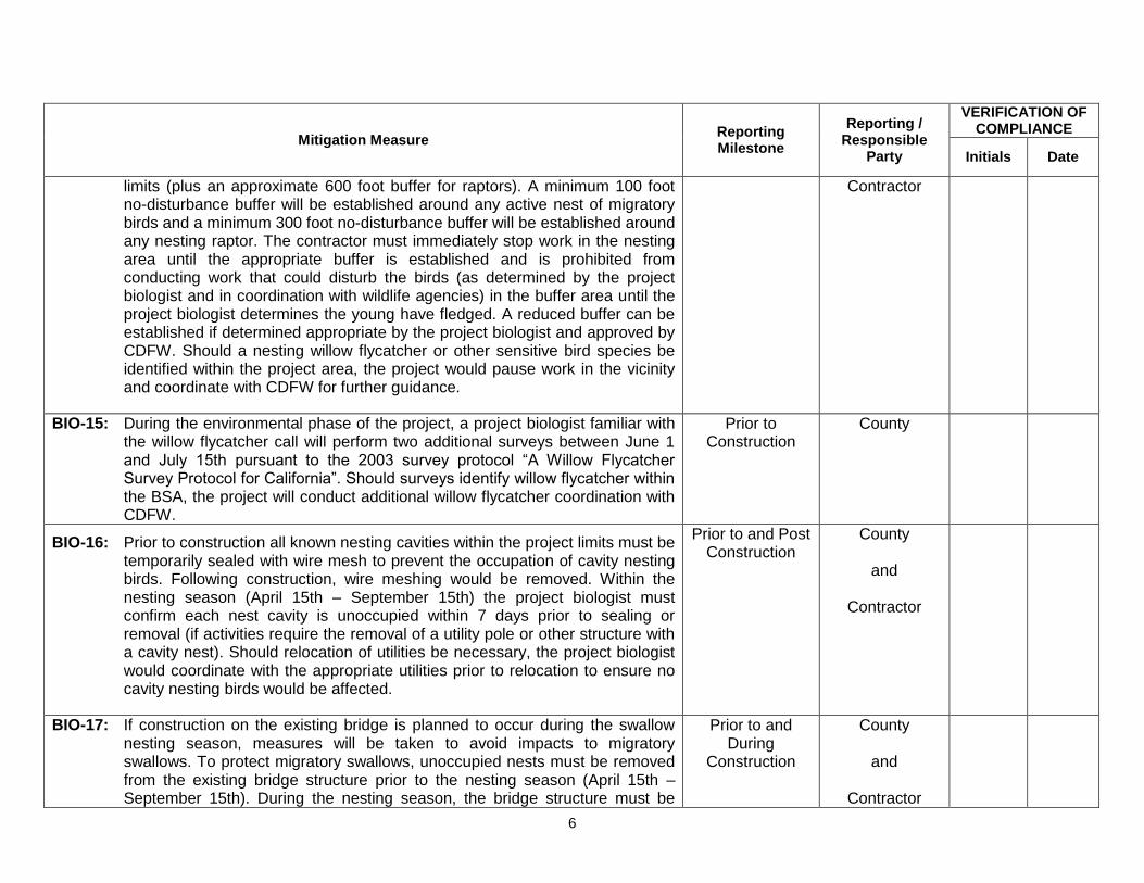
6
Mitigation Measure Reporting Milestone
Reporting / Responsible
Party
VERIFICATION OF COMPLIANCE
Initials Date
limits (plus an approximate 600 foot buffer for raptors). A minimum 100 foot no-disturbance buffer will be established around any active nest of migratory birds and a minimum 300 foot no-disturbance buffer will be established around any nesting raptor. The contractor must immediately stop work in the nesting area until the appropriate buffer is established and is prohibited from conducting work that could disturb the birds (as determined by the project biologist and in coordination with wildlife agencies) in the buffer area until the project biologist determines the young have fledged. A reduced buffer can be established if determined appropriate by the project biologist and approved by CDFW. Should a nesting willow flycatcher or other sensitive bird species be identified within the project area, the project would pause work in the vicinity and coordinate with CDFW for further guidance.
Contractor
BIO-15: During the environmental phase of the project, a project biologist familiar with the willow flycatcher call will perform two additional surveys between June 1 and July 15th pursuant to the 2003 survey protocol “A Willow Flycatcher Survey Protocol for California”. Should surveys identify willow flycatcher within the BSA, the project will conduct additional willow flycatcher coordination with CDFW.
Prior to Construction
County
BIO-16: Prior to construction all known nesting cavities within the project limits must be temporarily sealed with wire mesh to prevent the occupation of cavity nesting birds. Following construction, wire meshing would be removed. Within the nesting season (April 15th – September 15th) the project biologist must confirm each nest cavity is unoccupied within 7 days prior to sealing or removal (if activities require the removal of a utility pole or other structure with a cavity nest). Should relocation of utilities be necessary, the project biologist would coordinate with the appropriate utilities prior to relocation to ensure no cavity nesting birds would be affected.
Prior to and Post Construction
County
and
Contractor
BIO-17: If construction on the existing bridge is planned to occur during the swallow nesting season, measures will be taken to avoid impacts to migratory swallows. To protect migratory swallows, unoccupied nests must be removed from the existing bridge structure prior to the nesting season (April 15th – September 15th). During the nesting season, the bridge structure must be
Prior to and During
Construction
County
and
Contractor

7
Mitigation Measure Reporting Milestone
Reporting / Responsible
Party
VERIFICATION OF COMPLIANCE
Initials Date
maintained through the active removal of partially constructed nests. Swallows can complete nest construction in approximately 3 days. After a nest is completed, it can no longer be removed until an approved biologist has determined that all birds have fledged and the nest is no longer being used.
BIO-18: If any wildlife is encountered during the course of construction, said wildlife will be allowed to leave the construction area unharmed.
During Construction
Contractor
BIO-19: A pre-construction clearance survey will be conducted by the project biologist to verify that no wildlife is located within the project area.
Prior to Construction
County
BIO-20: The contractor must dispose of all food-related trash in closed containers, and must remove it from the project area each day during construction. Construction personnel must not feed or attract wildlife to the project area.
During Construction
Contractor
CULTURAL RESOURCES CR-1: Prior to construction, environmental awareness training will be provided to all
construction workers onsite regarding the possibility of encountering subsurface cultural resources. Native American groups have expressed concerns regarding the Native American resources in the immediate area. The Colfax-Todds Valley Consolidated Tribe will be notified at least 2 weeks prior to construction to allow for the tribe to monitor, if they choose to do so. Continued consultation will continue throughout the course of the project.
Prior to Construction
County
and
Contractor
CR-2: If previously unidentified cultural materials are unearthed during construction, work shall be halted within 200 feet of the affected area until a qualified archaeologist can assess the significance of the find and develop a plan for documentation and removal of resources, if necessary. Additional archaeological survey will be needed if project limits are extended beyond the present survey limits.
Prior to and During
Construction
County
and
Contractor
CR-3: Section 5097.94 of the Public Resources Code and Section 7050.5 of the California Health and Safety Code protect Native American burials, skeletal remains and grave goods, regardless of age and provide method and means for the appropriate handling of such remains. If human remains are encountered, work should halt in that vicinity and the county coroner should be
During Construction
County
and
Contractor

8
Mitigation Measure Reporting Milestone
Reporting / Responsible
Party
VERIFICATION OF COMPLIANCE
Initials Date
notified immediately. At the same time, an archaeologist should be contacted to evaluate the situation. If the human remains are of Native American origin, the coroner must notify the Native American Heritage Commission within twenty-four hours of such identification. CEQA details steps to be taken if human burials are of Native American origin.
HAZARDS AND HAZARDOUS WASTE HAZ-1: The contractor shall prepare spill and leak prevention procedures prior to the
commencement of construction activities. The procedures shall include information on the nature of all hazardous materials that shall be used on-site. The procedures shall also include information regarding proper handling of hazardous materials, and clean-up procedures in the event of an accidental release. The phone number of the agency overseeing hazardous materials and toxic clean-up shall be provided.
Prior to During Construction
Contractor
HAZ-2: The contractor(s) will prepare and implement an Asbestos Dust Management Plan (ADMP) that describes measures that will be taken to mitigate the potential airborne suspension of NOA-containing dust from the soil/rock as a result of construction excavation activities. Asbestos dust control to be implemented shall be in compliance with the following: • CCR § 93105 (Asbestos Airborne Toxic Control measure for Construction,
Grading, Quarrying, and Surface Mining Operations (ATCM 930105); • CCR § 93106 ((Asbestos Airborne Toxic control measure for Surfacing
Applications (ATCM 93106)); • Northern Sierra Air Quality Management District guidelines;
Prior to During Construction
Contractor
HAZ-3: According to Title 17 CCR, § 93106(i)(20), the soil/rock material within the southwestern roadway shoulder of the site is considered Restricted Material because the soil/rock material there contains asbestos at 0.25% or greater. Therefore, it cannot be used under the definition of surfacing (Title 17 CCR, § 93106(i)(26)). As required by the Title 17 CCR, § 93105(e)(4)(G), disturbed asbestos-containing material (0.25% asbestos or greater) must be stabilized via options that include paving or covering with at least 3 inches of non-asbestos-containing material (less than 0.25% asbestos).
During Construction
County
and
Contractor

9
Mitigation Measure Reporting Milestone
Reporting / Responsible
Party
VERIFICATION OF COMPLIANCE
Initials Date
Any part, other than a permitted landfill, receiving NOA-containing soil must be provided the following warning statement:
“WARNING! This material may contain asbestos.
It is unlawful to use this material for surfacing or any application in which it would remain exposed and subject to possible disturbance.
Extreme care should be taken when handling this material to minimize the generation of dust.”
HAZ-4: As is the case for any project that proposes excavation, the potential exists for unknown hazardous contamination to be revealed during project construction. For any previously unknown hazardous waste/ material encountered during construction, the procedures outlined in the Caltrans Unknown Hazard Procedures (as seen Table 7-1.1 of the Caltrans Construction Manual) shall be followed.
During Construction
Contractor

10
Mitigation Measure Reporting Milestone
Reporting / Responsible
Party
VERIFICATION OF COMPLIANCE
Initials Date
HYDROLOGY AND WATER QUALITY WQ-1: BMPs will be incorporated into project design and project management to
minimize impacts on the environment including the release of pollutants (oils,
fuels, etc.):
The area of construction and disturbance would be limited to as small an
area as feasible to reduce erosion and sedimentation.
Measures would be implemented during land-disturbing activities to
reduce erosion and sedimentation. These measures may include mulches,
soil binders and erosion control blankets, silt fencing, fiber rolls, temporary
berms, sediment desilting basins, sediment traps, and check dams.
Existing vegetation would be protected where feasible to reduce erosion
and sedimentation. Vegetation would be preserved by installing temporary
fencing, or other protection devices, around areas to be protected.
Exposed soils would be covered by loose bulk materials or other materials
to reduce erosion and runoff during rainfall events.
Exposed soils would be stabilized, through watering or other measures, to
prevent the movement of dust at the project site caused by wind and
construction activities such as traffic and grading activities.
All construction roadway areas would be properly protected to prevent
excess erosion, sedimentation, and water pollution.
All vehicle and equipment maintenance procedures would be conducted
off-site. In the event of an emergency, maintenance would occur away from
the South Yuba River.
All concrete curing activities would be conducted to minimize spray drift and
During Construction
Contractor
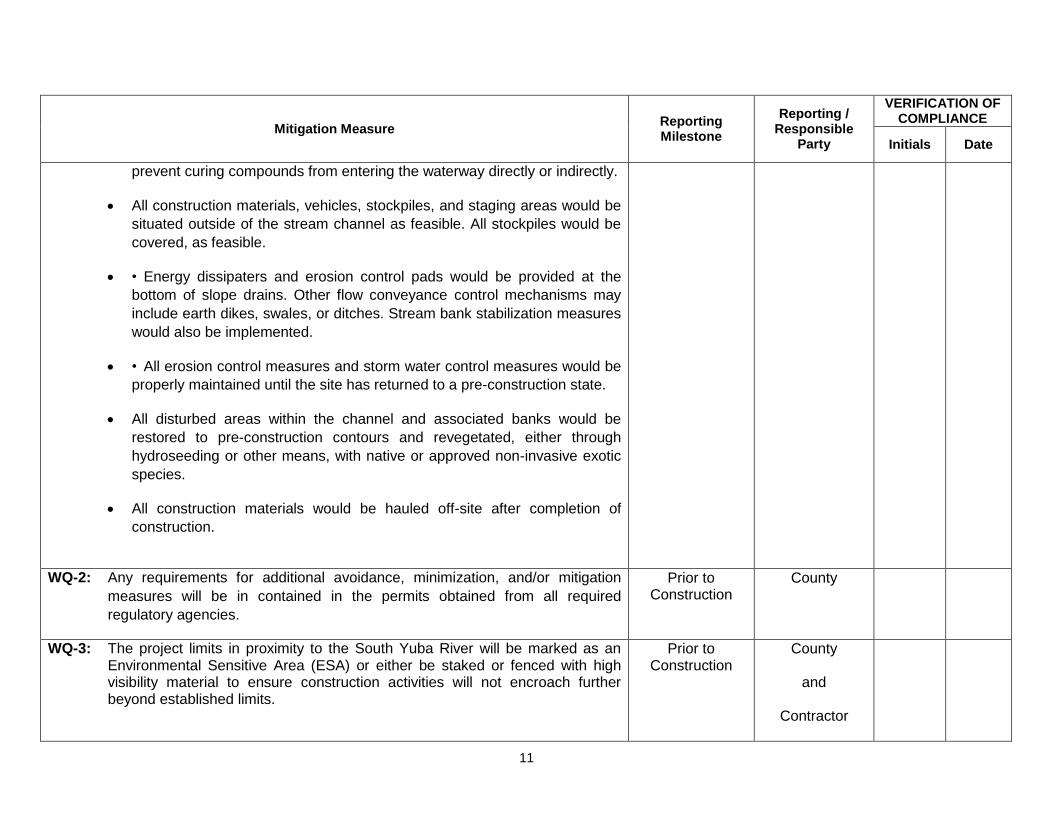
11
Mitigation Measure Reporting Milestone
Reporting / Responsible
Party
VERIFICATION OF COMPLIANCE
Initials Date
prevent curing compounds from entering the waterway directly or indirectly.
All construction materials, vehicles, stockpiles, and staging areas would be
situated outside of the stream channel as feasible. All stockpiles would be
covered, as feasible.
• Energy dissipaters and erosion control pads would be provided at the
bottom of slope drains. Other flow conveyance control mechanisms may
include earth dikes, swales, or ditches. Stream bank stabilization measures
would also be implemented.
• All erosion control measures and storm water control measures would be
properly maintained until the site has returned to a pre-construction state.
All disturbed areas within the channel and associated banks would be
restored to pre-construction contours and revegetated, either through
hydroseeding or other means, with native or approved non-invasive exotic
species.
All construction materials would be hauled off-site after completion of
construction.
WQ-2: Any requirements for additional avoidance, minimization, and/or mitigation
measures will be in contained in the permits obtained from all required
regulatory agencies.
Prior to Construction
County
WQ-3: The project limits in proximity to the South Yuba River will be marked as an Environmental Sensitive Area (ESA) or either be staked or fenced with high visibility material to ensure construction activities will not encroach further beyond established limits.
Prior to Construction
County
and
Contractor

12
Mitigation Measure Reporting Milestone
Reporting / Responsible
Party
VERIFICATION OF COMPLIANCE
Initials Date
WQ-4: The proposed project would require a National Pollution Discharge Elimination System (NPDES) General Construction Permit for Discharges of storm water associated with construction activities (Construction General Permit 2012-0006-DWQ). As part of the Permit requirement, a Stormwater Pollution Prevention Plan (SWPPP) or Water Pollution Control Program (WPCP) would also be developed and implemented. The SWPPP or WPCP will incorporate all applicable BMPs to ensure that adequate measures are taken during construction to minimize impacts to water quality.
Prior to and During
Construction
County
and
Contractor
WQ-5: Post-construction storm water control requirements will be addressed in accordance with Caltrans’ MS4 permit for areas within Caltrans right-of-way. Permanent treatment control BMPs will be evaluated based on effectiveness and feasibility and incorporated into the final design as applicable.
Prior to and During
Construction
County
and
Contractor
NOISE NOI-1: Project construction activities will be limited to 7:00 am – 7:00 pm Monday to
Friday, and 8:00 am – 6:00 pm Saturday and Sunday.
During Construction
Contractor

APPENDIX G – RESPONSE TO PUBLIC COMMENTS
This appendix contains the comments received during the public circulation and comment period
from ____________, to ____________. A response follows each comment presented.