1
County Mapbook 2014 County Mapbook 2014 Page iv Vehicle Miles Traveled, or VMT, is the sum of miles traveled by all vehicles on a specific segment of road within a period of time. VMT is calculated by multiplying the annual average daily traffic (AADT) volume for a specific segment of road - collected at traffic monitoring stations - by the length of that road segment to derive the total number of vehicle miles traveled on that road segment annually. The calculated VMT estimates are then aggregated by county to provide an estimate of the percent change in VMT for each county. This map depicts total VMT for each county in Texas overlaid with oil & gas production areas and shows a strong correlation between increases in VMT and increased oil & gas activities. Change in VMT (2000 - 2012) 86% to 506% 35% to 85% 12% to 34% - 3% to 11% - 41% to - 4% Oil and Gas Production Areas 2000-2012 Sources: VMT derived from 2000 - 2012 AADT data - Transportation Planning & Programming Division, TxDOT Oil & Gas map data obtained from the Railroad Commission of Texas Percent Change in Daily Vehicle Miles Traveled (VMT) Contact Information Transportation Planning and Programming Division Attn: Data Management Section P.O. Box 149217 Austin, Texas 78714-9217 Phone: (512) 486-5052 Fax: (512) 486-5099 Email: [email protected] Copyright 2014 Texas Department of Transportation This book was produced for internal use within the Texas Department of Transportation. Accuracy is limited to the validity of available data as of December 31, 2013. No portion of this map may be reproduced or stored electronically without the express written permission of the Texas Department of Transportation. The Texas Department of Transportation makes no claim as to the accuracy of the information contained within this book and some lands or roads depicted therein may be privately held. Always respect landowner privacy and follow the law. To report errors found within the County Mapbook 2014, or to make suggestions for future versions of the book, please contact us by mail, phone or email. Help keep Texas roadways safe and clean. Always buckle up and put litter in its place. Abbreviations Miscellaneous NF = National Forest NHP = National Historic Park NHS = National Historic Site NM = National Monument NP = National Park NPS = National Park Service NRA = National Recreation Area NWR = National Wildlife Refuge RES = Reservoir SHP = State Historic Park SNA = State Natural Area SP = State Park USFS = US Forest Service USFWS = US Fish & Wildlife Service WMA = Wildlife Management Area SS = State Highway Spur PR = Park Road FM = Farm to Market Road RM = Ranch to Market Road RR = Ranch Road RE = Recreation Road RP = Recreation Road Spur FS = Farm to Market Spur RS = Ranch to Market Spur PA = Principal Arterial Street BF = Off Farm or Ranch Road Business Route Roadways IH = Interstate Highway BI = Off Interstate Business Route US = US Highway UA = US Highway Alternate UP = US Highway Spur SH = State Highway BS = Off State Highway Business/SH Alternate BU = Off State Highway Business/US Alternate SL = State Highway Loop Connecting Page 83 About the Mapbook Design The County Mapbook divides the state into 551 maps. These maps are referenced using the grid index on the inside front cover. Also contained within the Mapbook are feature indices and a reference map, which are located in the front of the book. The scale for core maps is 1:120,000 and one inch equals approximately 1.89 miles. Navigation Every map in the book is aligned with true geographic north. Additionally, each of the maps connects on one or more sides with surrounding maps, so you can follow a road north or south into the next county simply by turning the page. The number highlighted in blue is the page number. Adjacent maps are indicated by the number highlighted in orange. I Miles 0 2 4 1 No Adjoining Page - Map Page Page -131 Table of Contents Grid Index District Map Legend Maps Airports Cemeteries Cities Counties County Roads Federal Roads - Inside Cover - iii - iv - 5 - 556 - 558 - 571 - 577 - 579 - 770 Highways Major Lakes Military State and Federal Parks Prisons Railroads Rivers Schools Tollroads - 775 - 789 - 794 - 795 - 799 - 801 - 806 - 808 - 810 Legend Incorporated City ! ( Unincorporated Community Tollroad SH, BS U V 45 US, BU, UA, UP £ ¤ 77 SL, SS, PR 360 IH, BI § ¨ ¦ 35 FM, BF, RM, RR, RE, RS, PA 1889 County Line Railroad City Street or other Non-County Maintained Road County Road Campground Prison Military Installation School Park or Protected Land Dam Body of Water Gulf Intracoastal Waterway Flowing Stream Intermittent Stream Canal River Cemetery " ) C Airport Runway Airport e Airport [ t

County Mapbook 2014 Mapbook 2014 Page iv Vehicle Miles Traveled, or VMT, is the sum of miles traveled by all vehicles on a specific segment of road within a period of time. VMT is

Embed Size (px)

Citation preview

County Mapbook 2014County Mapbook 2014

Page iv

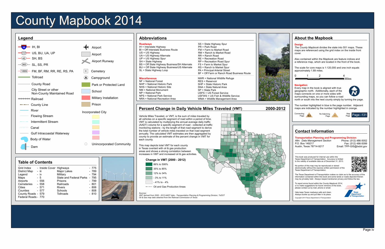
Vehicle Miles Traveled, or VMT, is the sum of miles traveled byall vehicles on a specific segment of road within a period of time.VMT is calculated by multiplying the annual average daily traffic(AADT) volume for a specific segment of road - collected at trafficmonitoring stations - by the length of that road segment to derivethe total number of vehicle miles traveled on that road segmentannually. The calculated VMT estimates are then aggregated bycounty to provide an estimate of the percent change in VMT foreach county.This map depicts total VMT for each countyin Texas overlaid with oil & gas productionareas and shows a strong correlation betweenincreases in VMT and increased oil & gas activities.

Change in VMT (2000 - 2012)86% to 506%35% to 85%12% to 34%- 3% to 11%- 41% to - 4%Oil and Gas Production Areas

2000-2012

Sources:VMT derived from 2000 - 2012 AADT data - Transportation Planning & Programming Division, TxDOTOil & Gas map data obtained from the Railroad Commission of Texas

Percent Change in Daily Vehicle Miles Traveled (VMT)

Contact InformationTransportation Planning and Programming DivisionAttn: Data Management SectionP.O. Box 149217Austin, Texas 78714-9217

Phone: (512) 486-5052Fax: (512) 486-5099

Email: [email protected]

Copyright 2014 Texas Department of Transportation

This book was produced for internal use within the Texas Department of Transportation. Accuracy is limited to the validity of available data as of December 31, 2013.No portion of this map may be reproduced or stored electronically without the express written permission of the Texas Department of Transportation.The Texas Department of Transportation makes no claim as to the accuracy of the information contained within this book and some lands or roads depicted therein may be privately held. Always respect landowner privacy and follow the law.To report errors found within the County Mapbook 2014, or to make suggestions for future versions of the book,please contact us by mail, phone or email.Help keep Texas roadways safe and clean.Always buckle up and put litter in its place.

Abbreviations

MiscellaneousNF = National ForestNHP = National Historic ParkNHS = National Historic SiteNM = National MonumentNP = National ParkNPS = National Park ServiceNRA = National Recreation Area

NWR = National Wildlife RefugeRES = ReservoirSHP = State Historic ParkSNA = State Natural AreaSP = State ParkUSFS = US Forest ServiceUSFWS = US Fish & Wildlife ServiceWMA = Wildlife Management Area

SS = State Highway SpurPR = Park RoadFM = Farm to Market RoadRM = Ranch to Market RoadRR = Ranch RoadRE = Recreation RoadRP = Recreation Road SpurFS = Farm to Market SpurRS = Ranch to Market SpurPA = Principal Arterial StreetBF = Off Farm or Ranch Road Business Route

RoadwaysIH = Interstate HighwayBI = Off Interstate Business RouteUS = US HighwayUA = US Highway AlternateUP = US Highway SpurSH = State HighwayBS = Off State Highway Business/SH AlternateBU = Off State Highway Business/US AlternateSL = State Highway Loop

ConnectingPage 83

About the MapbookDesignThe County Mapbook divides the state into 551 maps. These maps are referenced using the grid index on the inside front cover.Also contained within the Mapbook are feature indices anda reference map, which are located in the front of the book.The scale for core maps is 1:120,000 and one inch equalsapproximately 1.89 miles.

NavigationEvery map in the book is aligned with true geographic north. Additionally, each of the maps connects on one or more sides with surrounding maps, so you can follow a road north or south into the next county simply by turning the page. The number highlighted in blue is the page number. Adjacentmaps are indicated by the number highlighted in orange.

IMiles

0 2 41

No AdjoiningPage - Map

Page Page -131

Table of ContentsGrid IndexDistrict MapLegendMapsAirportsCemeteriesCitiesCountiesCounty RoadsFederal Roads

- Inside Cover- iii- iv- 5- 556- 558- 571- 577- 579- 770

HighwaysMajor LakesMilitaryState and Federal ParksPrisonsRailroadsRiversSchoolsTollroads

- 775- 789- 794- 795- 799- 801- 806- 808- 810

Legend

Incorporated City

!( Unincorporated Community

Tollroad

SH, BSUV45US, BU, UA, UP£¤77

SL, SS, PR360

IH, BI§̈¦35

FM, BF, RM, RR, RE, RS, PA1889

County LineRailroad

City Street or otherNon-County Maintained Road

County RoadCampground

PrisonMilitary InstallationSchoolPark or Protected Land

DamBody of WaterGulf Intracoastal Waterway

Flowing StreamIntermittent StreamCanal

River

Cemetery")C

Airport RunwayAirport

e Airport

[t