Embed Size (px)
Citation preview
COUNTRYASSESSMENTREPORT FORCAMBODIA
Strengthening ofHydrometeorological Servicesin Southeast Asia
ACKNOWLEDGMENTS
This Country Assessment Report for Cambodia is part of a study that aimed to strengthen the hydro-meteor-ological services in South East Asia. The production was a collaborative effort of the World Bank, the United Nations Office for Disaster Risk Reduction (UNISDR), the National Hydrological and Meteorological Services (NHMS) and the World Meteorological Organization (WMO) with financial support from the Global Facility for Disaster Reduction and Recovery (GFDRR).
The study investigated the capacity of the NHMS of five ASEAN Member States, namely Lao PDR, Cam-bodia, Indonesia, the Philippines and Viet Nam - to respond to the increasing demands for improved me-teorological and hydrological information by various socio-economic sectors. Taking a regional approach, it recommended investment plans to improve the NHMS with the ultimate goal for reducing losses due to natural hazard-induced disasters, sustainable economic growth and abilities of the countries to respond to climate change.
The Department of Meteorology (DOM) under the Ministry of Water Resources and Meteorology (MOWRAM) supported the country assessment and coordinated the participation of various ministries and departments, including the National Committee for Disaster Management (NCDM), the Department of Hydraulic Work, MOWRAM, the Ministry of Agriculture, Forestry and Fisheries (MAFF), the Ministry of Industry and Energy (MIME), Ministry of Environment, Cambodia Red Cross and others, to provide information, particularly on the sector needs.
The Disaster Risk Reduction Division of the WMO provided technical inputs and facilitated peer review of the draft reports, which have resulted in significant quality improvements.
The final draft report was reviewed by concerned national agencies and DOM supported the report finaliza-tion.
CONTENTS
EXECUTIVE SUMMARY 5 1 CAMBODIA IN A NUTSHELL 14 1.1 GENERAL DESCRIPTION 14 1.2 ECONOMY-OVERVIEW 16
2 SOCIO-ECONOMIC BENEFITS OF HYDRO-METEOROLOGICAL SERVICES 18 2.1 WEATHER AND CLIMATE-DEPENDENT ECONOMIC SECTORS 18 2.2 METHODOLOGY FOR COMPUTING SOCIO-ECONOMIC BENEFITS 18 2.3 RESULTS AND ANALYSIS 19
3 NEEDS ASSESSMENT OF SERVICES AND HYDROMETEOROLOGICAL INFORMATION 25 3.1 AGRICULTURE AND FOOD PRODUCTION 25 3.2 FISHERY 26 3.3 FOREST INDUSTRY 27 3.4 WATER MANAGEMENT 28 3.5 ENERGY 30 3.6 TRANSPORTATION 31 3.6.1 Land Transportation 31 3.6.2 Water Transportation 33 3.6.3 Air transportation 33 3.7 CONSTRUCTION 34 3.8 LAND USE AND PLANNING 34 3.9 TOURISM 35 3.10 INSURANCE 36 3.11 HEALTH 36 3.12 ENVIRONMENT 37 3.12.1 Water quality 37 3.12.2 Air quality 37 3.13 DISASTER RISK REDUCTION 38 3.14 MILITARY 39 3.15 CLIMATE CHANGE 40 3.16 MEDIA 44
4 THE METEOROLOGICAL AND HYDROLOGICAL SERVICE OF CAMBODIA IN A NUTSHELL 45 4.1 BRIEF HISTORY 45 4.2 ORGANIZATIONS WITH RESPONSIBILITY FOR HYDROMETEOROLOGICAL AND RELATED SERVICES IN CAMBODIA 46 4.3 GENERAL INFORMATION 46 4.4 EVALUATION CRITERION 47 4.5 ANNUAL REPORT 47 4.6 ORGANIZATIONAL STRUCTURE 47 4.7 REGIONAL CENTRES AND OFFICES 48 4.8 BUDGET AND ACCOUNTING SYSTEM 48 4.9 HUMAN RESOURCES 48 4.10 TRAINING PROGRAMMES 49 4.11 PREMISES 49

4.12 VISIBILITY OF DOM 49 4.13 INTERNATIONAL MEMBERSHIPS AND NETWORKING 50 4.14 COOPERATION WITH OTHER USERS OF HYDRO-METEOROLOGICAL SERVICES IN CAMBODIA 50
5 CURRENT SERVICES OF DOM 51 5.1 WEATHER SERVICES 51 5.1.1 Forecasts and Tropical Cyclone Warnings Dissemination 51 5.2 EARLY WARNING SYSTEM 53 5.3 CLIMATOLOGICAL SERVICES 54 5.4 AGROMETEOROLOGICAL SERVICES 55 5.5 HYDROLOGICAL SERVICES 55 5.6 MARINE SERVICES 57 5.7 ENVIRONMENTAL SERVICES 57 5.7.1 Water quality 57 5.7.2 Air quality 57 5.8 UV RADIATION: NONE 57 5.9 CLIMATE CHANGE RELATED SERVICES 57 5.10 R&D BASED EXPERT SERVICES 57 5.11 INFORMATION SERVICES 57
6 CAMBODIA’S NETWORK OF OBSERVING STATIONS 58 6.1 METEOROLOGICAL STATIONS 58 6.2 CLIMATOLOGICAL STATIONS 58 6.3 RAINFALL STATIONS 59 6.4 HYDROLOGICAL STATIONS 59 6.5 AGROMETEOROLOGICAL OBSERVATIONS 60 6.6 MARINE OBSERVATIONS 60 6.7 AIR QUALITY OBSERVATIONS 60 6.8 WATER QUALITY OBSERVATIONS 60 6.9 LIGHTNING 61 6.10 SATELLITE 61
7 MAINTENANCE, CALIBRATION AND MANUFACTURING OF MEASUREMENT SYSTEMS 62 7.1 METEOROLOGICAL OBSERVATIONS 62 7.2 HYDROLOGICAL OBSERVATIONS 62 7.3 ENVIRONMENTAL OBSERVATIONS 62
8 NUMERICAL WEATHER PREDICTION (NWP) 63 8.1 OPERATIONAL MODELS 63 8.2 VERIFICATION OF NWPS 64
9 INFORMATION, COMMUNICATION AND TECHNOLOGY 65 9.1 COMMUNICATION FACILITIES 65 9.2 DATA MANAGEMENT 67 9.3 IT INFRASTRUCTURE 67 9.4 IT PERSONNEL 67 9.5 NEEDS TO IMPROVE COMMUNICATION SYSTEM AND DATA MANAGEMENT 67
10 NATIONAL AND INTERNATIONAL COOPERATION AND DATA SHARING 68 10.1 NATIONAL 68 10.2 INTERNATIONAL 68
11 RECENT DEVELOPMENT PLANS PROPOSED BY CAMBODIA 69
12 SUMMARY 72
13 RECOMMENDATIONS TO STRENGTHEN THE HYDROMETEOROLOGICAL SERVICES 76
14 PROJECT PROPOSAL 78 14.1 INTERNATIONAL COOPERATION 79 14.2 TELECOM, IT AND DATA MANAGEMENT 79 14.3 METEOROLOGICAL OBSERVATION NETWORK 80 14.4 HYDROLOGICAL STATIONS (UNDER DHRW, MOWRAM) 80 14.5 ENVIRONMENTAL STATIONS 80 14.6 REMOTE SENSING NETWORK 80 14.7 VISUALIZATION DISPLAY SYSTEM 82 14.8 LIGHTNING DETECTION SYSTEM 82 14.9 CLIMATE CHANGE 82 14.10 TRAINING 82
PEOPLE MET DURING THE MISSION 89 REFERENCES 90
APPENDICES - TABLES 92
FIGURES
Figure 1.1 Geographical location of Cambodia Figure 3.1 Distribution of Agricultural lands in CambodiaFigure 3.2 Total rice production in Cambodia from 1980 to 2006Figure 3.3 Distribution of water utilization in Cambodia Figure 3.4 The main tourist attraction in Cambodia, the Angkor Wat TempleFigure 3.5 Organizational structure of the NCDM Figure 3.6 Climate management structure in Cambodia Figure 3.7 Historical and future mean temperature over land area of Cambodia (based on PRECIS) Figure 3.8 Historical change (trend) of seasonal rainfall in Cambodia (1960-2000) Figure 4.1 New Organizational Structure of DOM Figure 4.2 Headquarters building of DOM and BHRW Figure 4.3 Computer facility of the DOM Figure 5.1 Dissemination of Weather Bulletins and warnings Figure 5.2 Flood warnings and bulletin from Flood forecast model by the DHRW (Source: Saravuth, 2005) Figure 5.3 Flood warning procedures based on observed and forecast water levels Figure 5.4 Relationship of rice production and wet season rainfall anomaly (Source: Ponlok, 2010) Figure 5.5 Organizational structure of the DHRW Figure 5.6 BHRW website where hydrological information and flood bulletin are posted Figure 6.1 Meteorological network of stations in Cambodia Figure 6.2 Locations of hydrological stations in Cambodia Figure 6.3 Location of water quality monitoring stations in Cambodia Figure 6.4 Training on MTSAT operation by JICA at Pochentong Figure 6.5 The MTSAT satellite disc to be reinstalled at the rooftop of the new building Figure 8.1 DSF output showing the status of the river system in Cambodia Figure 9.1 Communication facility for domestic stations Figure 9.2 Regional telecommunication network for Region II (Asia) Figure 11.1 Cambodia Post Disaster Needs Assessment Report prepared through the assistance of the World Bank Figure 14.1 Existing network of weather radars in Indochina
Table 1 Options, Costs, Discounted Total Benefits, Discounted Net Benefits and Cost-Benefit ratios for improvements in NMHS in Cambodia, 2010-2029 Table 2.1 Percent share of value added by weather and climate-dependent economic sector to Gross Domestic Product at 1990 constant prices of the Cambodia, 2000-2007Table 2.2 Socio-economic sectors and the potential direct damages due to weather and climate-related natural disasters on different economic and social sectors Table 2.3 Selected statistics related to weather and climate-related disasters in the Cambodia, 1990 to 20099 Table 2.4 Actual and Estimated economic value of damages due to weather and climate-related natural disasters in Cambodia, 1990-2029 (million US dollars) Table 2.5 Estimated reduction in the socio-economic damages, or the socio-economic benefits due to improvements in NMHS in Cambodia, 2010-2029 (million US dollars) Table 2.6 Discounted value of the estimated reduction in socio-economic damages, or the socio-economic benefits, due to improvements in NMHS in Cambodia, 2010-2029 (million US dollars) Table 2.7 Options, Costs, Discounted Total Benefits, Discounted Net Benefits and Cost-Benefit ratios for improvements in NMHS in Cambodia, 2010-2029 Table 3.1 Water Resource Potential in Cambodia Table 3.2 Power Demand Forecast (MW)Table 9.1 Communication facilities for transmission, reception and exchange of data and products. RD = to receive data/observations, RI = to receive information/products, SD = to send data/ observation, SI = to send information/products, RW = to receive warnings, SW = to send warnings. Table 11.1 Recovery and Reconstruction Needs of Cambodia after TY Ketsana Table 11.2 Recovery framework and tentative donor commitment Table 12.1 Issues, institutional capacities, gaps and needs of DOM and DHRWTable 12.2 Meteorological and hydrological data, products and services required by sectorTable 12.3 Evaluation of level of different skills of DMHTable 14.1 Distribution of the costs of a 5 year project in the case all the investments are done in the first year Table 14.2 JICA Proposal for the provision of 24 Automatic Weather Station (AWS) For the Improvement of Meteorological Observation in Cambodia
Appendix TablesTable 1 Number of weather and climate-related disasters in Cambodia, 2005-2009Table 2 Number of weather and climate-related deaths in Cambodia, 2005-2009Table 3 Actual socio-economic damages due to weather and climate-related disasters in Cambodia, 2005-2029 (million US dollars)Table 4 Summary of damages caused by natural disasters, Cambodia 2000-2009Table 5 The main qualitative benefits and impacts of meteorological and hydrological information services in general level
TABLES
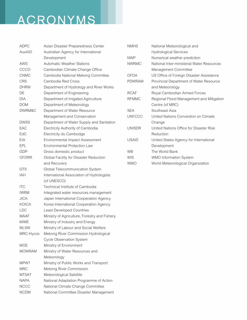
ACRONYMS
ADPC Asian Disaster Preparedness CenterAusAID Australian Agency for International DevelopmentAWS Automatic Weather StationsCCCO Cambodian Climate Change Office CNMC Cambodia National Mekong CommitteeCRS Cambodia Red CrossDHRW Department of Hydrology and River WorksDE Department of EngineeringDIA Department of Irrigated Agriculture DOM Department of Meteorology DWRM&C Department of Water Resource Management and Conservation DWSS Department of Water Supply and Sanitation EAC Electricity Authority of Cambodia EdC Electricity du Cambodge EIA Environmental Impact AssessmentEPL Environmental Protection LawGDP Gross domestic productGFDRR Global Facility for Disaster Reduction and RecoveryGTS Global Telecommunication SystemIAH International Association of Hydrologists (of UNESCO)ITC Technical Institute of CambodiaIWRM Integrated water resources managementJICA Japan International Cooperation AgencyKOICA Korea International Cooperation AgencyLDC Least Developed CountriesMAAF Ministry of Agriculture, Forestry and FisheryMIME Ministry of Industry and EnergyMLSW Ministry of Labour and Social WelfareMRC-Hycos Mekong River Commission Hydrological Cycle Observation SystemMOE Ministry of EnvironmentMOWRAM Ministry of Water Resources and MeteorologyMPWT Ministry of Public Works and TransportMRC Mekong River CommissionMTSAT Meteorological SatelliteNAPA National Adaptation Programme of ActionNCCC National Climate Change Committee NCDM National Committee Disaster Management
NMHS National Meteorological and Hydrological ServicesNWP Numerical weather predictionNWRMC National Inter-ministerial Water Resources Management Committee OFDA US Office of Foreign Disaster Assistance PDWRAM Provincial Department of Water Resource and Meteorology RCAF Royal Cambodian Armed Forces RFMMC Regional Flood Management and Mitigation Centre (of MRC)SEA Southeast AsiaUNFCCC United Nations Convention on Climate ChangeUNISDR United Nations Office for Disaster Risk Reduction USAID United States Agency for International DevelopmentWB The World BankWIS WMO Information SystemWMO World Meteorological Organization
5
EXECUTIVE SUMMARY
All human activities are linked to weather and climate.As a matter of fact, various economic sectors have started to appreciate the value of weather forecasts due to worsening impacts of hydrometeorological related hazards as a result of changing weather patterns. The extreme events that were experienced in recent years are precursors of the impacts of a changing climate. With climate change, the impacts will exacerbate and will continuously affect all sectors in unprecedented ways, particularly in many areas where water is a limited resource. On the other hand, tropical cyclones can generate extreme rainfall event resulting to catastrophic flooding. The attendant weather extremes manifested in floods and droughts considerably decrease agricultural productivity and aquaculture. Accelerated sea level rise will expose more people to the risk of coastal flooding while increased exposure to vector-borne infectious diseases and heat stress will threaten human health. Moreover, tourism which is an impor-tant source of income would be affected by severe disruption from climate change and sea level rise.
As more weather extremes start to unfold, demand for more accurate, timely and effective weather forecasts and climate prediction at all time scales and other crucial information will be sought for the human safety and well being and for planning. Hence, national meteorological and hydrological services (NMHS) will need to expand to meet the emerging needs of the various economic sectors.
To achieve or address such demand, it is urgent to put in place or enhance the very basic requirements for an NMHS to function effectively: 1) adequate networks to monitor hydrometeorological parameters;2) a robust communication system for data trans-mission, disseminate of forecasts and sharing of information; 3) high speed computing system for data assimilation and ensemble forecasting;
4) human resource equipped with appropriatetrainings; and 5) more interaction with users of weather and climate information. But the transboundarynature of weather-causing phenomena would requirecollaboration among NMHS in the region; hence there is now an urgent need to enhance regional cooperation and data sharing which is currently being undertaken by the World Meteorological Organization (WMO) through its WMO Information System (WIS).
Assessment of needs of improved hy-drometeorological services in Cambodia
In its current capacity, the Department of Meteorology(DOM) is mandated to provide the basic services needed for disaster risk reduction in Cambodia. It has recently undergone a major change in leadership. After some internal administrative problems, the new acting Director is making his best effort to cope with the challenges facing the department. Compared to other countries in the region, DOM is lagging behind in terms of equipment and forecasting technologies such as numerical weather and climate modeling as well as human resources and institutional capacity. It has a research and development unit but it does not work on the advancement of their services. With its current state of physical and human resources, it cannot cope with the increasingdemand from different socio-economic sectors.
After the Typhoon Ketsana that hit Cambodia in 2009, DOM faces a great challenge to improve on its tropical cyclone forecasting. All sectors of the society were seriously affected by the typhoon, leading to a massive rehabilitation program. Assistance from foreign donors came in. However, the upgrading of DOM’s capabilities was not given
The role of hydro-meteorological services
6
due consideration in the rehabilitation program. Accurate and advance forecast of the cyclone’s track could have saved lives and properties. Advance warning would enable the people to move to safer grounds and make precautionary measures.There are large spatial, temporal and parameters data gaps for effective integrated water resource development and planning as well. This study hopes to highlight the importance of DOM’s services.
There is the lack of knowledge of the available hydrometeorological services in more economically advanced countries and the possibilities to produce more end-user specific services have not been well recognized by most of the socio-economic sectors in Cambodia. Also the sectors have not yet appreciated the importance of hydrometeorological services for the improvement of their production and productivity. It seems that DOM is performing its task as a separate entity and not linked with the other sectors. The DOM has no annual budget. It has no program to network or link with the end users and stakeholders of weather services. It does not have a well defined linkage with many of the potential users of hydrometeorological services despite the increasing need and potential market for improved meteorological services especially after the passage of Tropical Cyclone Ketsana. There is a need to increase dialogue and partnerships between DOM and the socio-economic sectors. This gap on communication and cooperationwith the stakeholders and users of weather and climate information should therefore be reduced if not eliminated. This would yield better services and obviously also promote private sector participation to invest in the establishment or enhancement of meteorological observation network.
National set-up for production of hydro-meteorological services in Cambodia
The DOM is under the Ministry of Water Resources and Meteorology (MOWRAM) which is mandated to provide weather services for Cambodia. It is responsible for the operation and maintenance of all the meteorological observation and measurements, issuance of weather forecasts and severe weather warnings all over the country. It provides weather services to aviation and land transportation, agri-culture and other sectors. It plays a vital role in disaster management being a member of the National Committee for Disaster Management (NCDM) to assist in decision making for taking prompt actions toward hydro-meteorological induced disasters. It assists the National Climate Change Committee (NCCC) by providing climatological information particularly for climate change projections.
The local visibility of the DOM to the public and in the science community is poor. MOWRAM and DOM officials should exert efforts to communicate with the media to publicize their services. Currently, DOM has no website to publish its activities and services to the public. DOM’s activities are mostly confined to provision of weather forecasts and meteorological data to other sectors and provision of lectures. Collaborative projects with other government agencies like the Ministry of Environment (MOE), Ministry of Agriculture, Forestry and Fisheries (MAFF), etc. should be enhanced. Most importantly, the DOM should work closely with the Department of Hydrology and River Works (DHRW), also under MOWRAM to expand flood forecasting currently covers only three days forecast for five stations along the Mekong mainstream to cover vulnerable areas on major tributaries.
7
The Kingdom of Cambodia, as an agrarian country,is highly vulnerable to the impacts of extreme climate events. It is vulnerable to weather and water related hazards as more than 80 percent of its population is subsistence farmers. Adverse impacts are already being felt and these include increased flood and drought damages, reduction in crop yields, decrease water availability and increase in the number of people exposed to vector and water-borne diseases. Based on data from the past five years, Cambodia’s paddy production was destroyed by as much as 70 percent by floods, and 20 percent and 10 percent, respectively by droughts and diseases. The recent strong typhoon Ketsana was a manifestation of a severe weather event that devastated the country. It is therefore important to upgrade the capabilities of the DOM and DHRW to provide quality products and services such as timely and accurate forecasts and warnings.
The Department of Hydrology and River Works (DHRW) is responsible for hydrological services in Cambodia. It maintains and monitors hydrological stations along the rivers systems of Cambodia particularly the major rivers of Mekong, Bassac and Tonle Sap. It provides three days water level and flood forecasting for seven stations along the Mekong-Tonle Sap- Bassac rives using simple regression models.
In order to cope up with the growing demand for hydrometeorological information/services and the fast technological advancement, automation in the DOM is a necessity. It is therefore critical that there is a national vision, development plan and strategy to improve the network of monitoring and production of weather and climate services in order to meet the basic need of environment protection through the provision of accurate weather forecasts.
State of affairs of the DOM
Compared to most of the NMHSs in the Southeast Asian countries, DOM has relatively limited technical, human and financial resources to carry out its mission. Its observation network, production system and its current financial resources are not adequate to ensure the expected quantity and quality of data to meet the rapidly growing needs of global and regional weather forecasting, early warning systems for natural hazards, and of national public and ifferent socio-economic sectors.
The DOM is one of the six technical departments of the MOWRAM, which is mandated to install and manage the weather monitoring network throughout Cambodia; monitor weather condition happening in the region; and issue weather forecast and provide warning on weather condition to relevant ministries and public via media. In dealing with hydromete-orological hazards, DOM partners with the DHRW, which is responsible for flood forecasting and warning. As regards to its duties and responsibilities,DOM has special relationships and responsibilities with several ministries and state bodies such as Ministry of Environment, Ministry of Agriculture Forestry and Fishery, National Committee for Disaster Management, Ministry of Public Works and Transport (MPWT), Ministry of Labor and Social Welfare (MLSW), Ministry of Industry, Mines and Energy (MIME), and the Cambodian Red Cross (CRS).
The DOM is headed by a Director who reports directly to the Minister. It is composed of six offices namely: Administrative Office, Observation Office, Equipment Office, Forecasts and Researches Office, and Climate Office and Hydrometeorological Office.
8
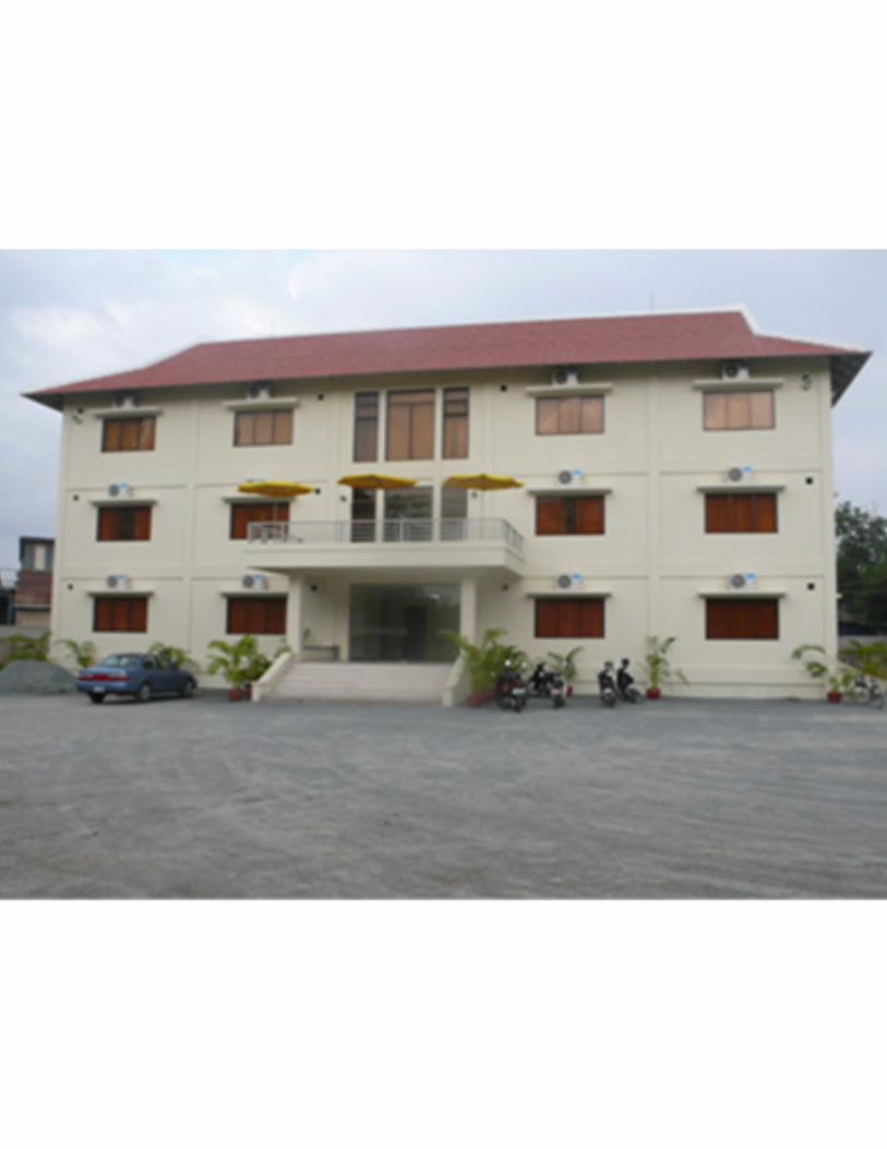
In each of the 24 provinces and municipalities, the Hydrometeorological Offices are established under the Provincial Department of Water Resource and Meteorology (PDWRAM). The DOM’s head-quarters is presently housed at the ground floor of a new 3-storey building of MOWRAM located and at the Doppler Radar building at M.V. Preah Monivong, Phnom Penh, Cambodia.
DOM employs a total of 44 staff at the Headquarters in Phnom Penh distributed in 5 offices: Administration = 5, Observation = 10, Research and Forecasting = 9, Climate = 9, and Equipment Management = 9. There are 34 males and 10 females. Five staffs are trained as professional meteorologists (with bachelor or master degree) other three undergraduates were trained in other disciplines, and 35 technicians. All the Master’s Degree holders obtained their diplomafrom Russian universities through scholarship grants and the engineers and Bachelor Degree holders from Belgium, Viet Nam, Russia some twenty years ago and Cambodia (technicians meteorolo-gists CL3). There are only one or two technicians meteorologists or hydrologists in some of the Provincial Hydrometeorological offices, totaling only 13 staffs, retired staffs are not replaced. DOM has recently recruited five IT staffs to handle the technical requirements of the newly installed Doppler rainfall radar. There is a big gap to fill in terms of the personnel complement of DOM. There is a need to increase the number of staff with higher academic education (MSc and PhD), employ more young technical staff and promote the retention of the newly recruited IT staff.
The DOM’s observation network in its current status is not capable of providing high quality information and services to the people. In the as-sessment made by the Asian Disaster Preparedness Center (ADPC) of the 13 surface meteorological observatories in Cambodia in July 2007, all the observatories are reported to be in primitive stage. Observed data consists mainly of temperature and
rainfall. Other instruments i.e. cup anemometers, barographs, are not working. The main constrains in the observation and monitoring network are the lack of automatic meteorological stations (some 10 automatic weather stations installed between 2001 and 2002 are no more operational), no upper-air observing station, the new weather radar could still not effectively operated and lack fast and modern telecommunication system. Moreover, DOM is not running any NWP models resulting to the low accuracy of the forecasts.
The Government is exerting efforts to upgrade the capability of DOM. The provision of new headquarters office1 is a proof to this. There have also been some significant changes related to hydrometeorological network development and management in Cambodia.In terms of meteorological equipment, the Asian Disaster Preparedness Center (ADPC) provided 10 sets of semi-automatic weather stations in 2009. Nevertheless, these stations have not been installed due to lack of funds and expertise.
In 2012, MOWRAM installed and put into operation under the government budget a Doopler Rainfall radar (C band), which is expected to improve weather and rainfall forecasting. However, it is still facing with many difficulties, mainly the lack of experience and dedicated meteorologist to operate the system including conversion software.
The DOM is negotiating for the provision of 24 Automatic Weather Stations (AWS) to be installed at each of the province/municipalities, includingtraining.
1It is to be noted that the DOM new office building includes office space in the new radar tower is merely office space. As a technical service, the DOM needs more space as store room, for calibration and maintenance of equipment that are yet available at the current location. For activities expansion, DOM would need space for upper air station, national standard synoptic/ agro-meteorological stations, training facilities etc. The new site of the Pochentong (relocated station) must be carefully planned.
9
For hydrology, the Mekong River Commission Hydrological Cycle Observation System (MRC-Hycos) is under discussion for its extension. In terms of policy and institutional reform, the ADB in collaboration with a number of donors is financing the capacity technical assistance by providing specialist support to MOWRAM to: i. Develop its capacity to manage water resources through strengthening the strategy, policy and legal framework for integrated water resources management (IWRM); ii. Improve coordination and cooperation with other ministries and agencies, and at the river basin level; and iii. Strengthen MOWRAM's technical capacity to promote IWRM and climate change adaptation; and develop human resources capacity.
Component (ii) will establish the National Inter-ministerial Water Resources Management Committee (NWRMC) and component (iii) intends to support the training of some 300 water resources engineers in collaboration with the Technical Institute of Cambodia (ITC) in the next five years and the strengthening the capacity of MOWRAM in climate change policy and strategy. DOM and DHRW should in the same way try to plan and train their new staffs to enable them to deliver expected services.
The Government cannot fully support all the financialrequirements of DOM to produce increased and improved hydrometeorological services to support economic growth and the safety and wellbeing of the citizens. As a Least Developed Country (LDC), Cambodia has been striving for DOM’s enhancementthrough bilateral cooperation schemes. For instance,the grant assistance from the Government of Japan facilitated the transfer of knowledge and upgraded facilities, resulting in better forecasts. This also included the re-installation of the MTSAT in the new building and retraining of DOM’s staff.
Regional and international initiatives on disaster risk management are being implemented. Donors include World Bank, AusAID, UNDP, ADPC, among others. International support to DOM and other NMHSs in the SEA countries is a must to provide an opportunity to enhance the hydrometeorological measurements and services in Cambodia and in the region to a level sufficient to meet the national and regional needs for sustainable development of DOM and other NMHSs. However, on the contrary to DHRW, the DOM has never received a project but only some patchy technical assistance on an ad-hoc basis. It does not even have vehicles for field works such as station installation and inspections.
Project proposal to strengthen the DOM
To strengthen DOM and DHRW institutional and human capacity, a medium to long term plan is required to fill in the significant professional generation gaps of some twenty years and shortage of qualified staffs at all level as well as lack of leadership. This might need up to twenty years.
The first five years would be to focus on the restructuration planning of the DOM and DHRW in line with the Policy and Institutional Reform and Capacity Development in Water Sector of the MOWRAM. In this period, to enhance the capability of DOM as a warning institution for hydrometeoro-logical hazards, it is proposed to upgrade its physical and human resources. It needs to upgrade the 12 synoptic stations and manual or analogue instruments be replaced with automatic observation system2 . An upper-air observation station, one radar facility3 and about 3 lightning detectors4 should
2 JICA has proposed the provision of new AWS including training. The 10 semi-automatic stations provided by ADPC must also be installed immediately.3 The installed Doppler radar must be put to work more effectively requiring extra software and training as well as incentive to retain staff.4 Are essentials to make Doppler radar more effectively by detecting rainstorm activities

10
also be established for better assessment of the vertical structure of the atmosphere especiallyduring occurrence of tropical cyclones and deep mesoscale convective systems such thunderstorms and tornadoes. Composite radar images from all radar equipment from the neighbouring countries should be utilized through stronger regional cooperation. Advanced telecommunication system is necessary for the transmission of data from field stations and for fast dissemination of forecasts and warnings to the public and other end-users. A website should also be developed to make the weather forecasts readily available to the public. DOM needs to hone the skills of its human resources through the conduct of specialized and highly technical training courses to keep abreast with the fast pace of technology.
Climate change is another challenge for Cambodia. In addition to the increased reliability and timely weather forecasting and dissemination, information is also required for the grass root level to understand and adapt to the imminent foreseen impacts of climate change. Rainfall data collection is far from being adequate for flood/drought forecasting as well as medium to long term water availability in each of the sub-basin. The DOM and DHRW must review, upgrade and expand the national rainfall network at least to cover half of the country 1620 communes. A total of 800 manual raingauges are proposed to be installed in 800 communes to be the asset of the communes that can report near real time data for flood/drought forecasting for each of the major sub-basin in the country. This also includes the existing raingauges that need complete review.
Investment plan
The proposed project is designed to enable the DOM to provide reliable, timely, and accurate forecasts and warnings on weather related hazards for the safety and well being of the people and to promote the economic growth of Cambodia. This can be achieved through upgrading and modernizationof the facilities, capacity building and establishment of a strong research and development arm. This entails a significant investment particularly on the automation of the meteorological observing network including telecommunication facilities and other equipment. Investment will be reduced if cooperation with other Asian countries is strengthened through data sharing and training on compositing of all radar data and images available in the region. Joint projects on climate change and other global issues could also be considered to promote cooperation. Scholarship grants from international funding institutions can also reduce the required investment.
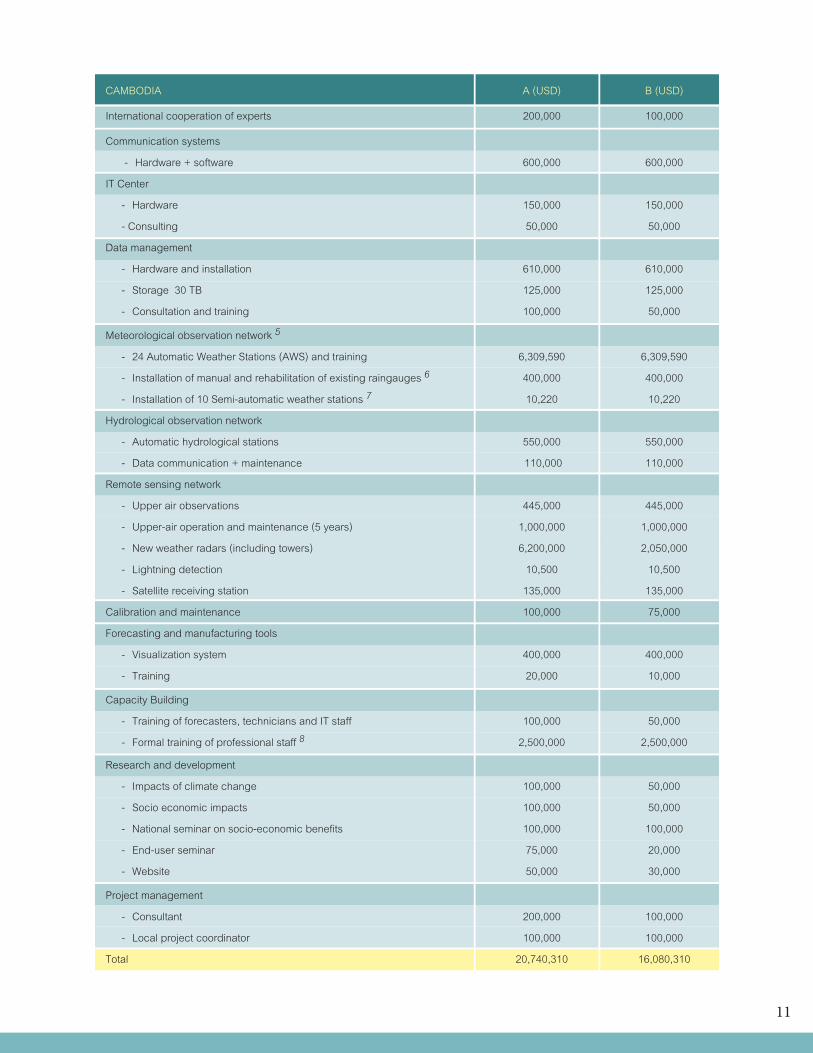
An investment plan is designed which includes funding for operation and maintenance cost during the implementation of the project. Two options for investment are proposed:
A) Strengthening of NHMS as “Stand-alone system”,B) Planning and implementing the strengthening as part of the cooperative project.
11
CAMBODIA A (USD) B (USD)
International cooperation of experts 200,000 100,000
Communication systems
- Hardware + software 600,000 600,000
IT Center
- Hardware 150,000 150,000
- Consulting 50,000 50,000
Data management
- Hardware and installation 610,000 610,000
- Storage 30 TB 125,000 125,000
- Consultation and training 100,000 50,000
Meteorological observation network 5
- 24 Automatic Weather Stations (AWS) and training 6,309,590 6,309,590
- Installation of manual and rehabilitation of existing raingauges 6 400,000 400,000
- Installation of 10 Semi-automatic weather stations 7 10,220 10,220
Hydrological observation network
- Automatic hydrological stations 550,000 550,000
- Data communication + maintenance 110,000 110,000
Remote sensing network
- Upper air observations 445,000 445,000
- Upper-air operation and maintenance (5 years) 1,000,000 1,000,000
- New weather radars (including towers) 6,200,000 2,050,000
- Lightning detection 10,500 10,500
- Satellite receiving station 135,000 135,000
Calibration and maintenance 100,000 75,000
Forecasting and manufacturing tools
- Visualization system 400,000 400,000
- Training 20,000 10,000
Capacity Building
- Training of forecasters, technicians and IT staff 100,000 50,000
- Formal training of professional staff 8 2,500,000 2,500,000
Research and development
- Impacts of climate change 100,000 50,000
- Socio economic impacts 100,000 50,000
- National seminar on socio-economic benefits 100,000 100,000
- End-user seminar 75,000 20,000
- Website 50,000 30,000
Project management
- Consultant 200,000 100,000
- Local project coordinator 100,000 100,000
Total 20,740,310 16,080,310
12
5 These include (i) the 24 AWS proposed by JICA (Table 14.2) and the 800 near real time manual raingauges.6 Existing rainfall station networks is in a very bad shapes since there was no systematic inspection, maintenance and repair as well as station history records and documentation7 There were some 10 semi automatic weather stations provided by ADPC that are not yet installed due to lack of funds and technical capacity8 Since the last 20 years there were no single staffs trained in Hydrology and Meteorology. The impact of investment in equipment will be minimal with declined number of well trained staffs (retirement and leaving for other better paid jobs)
It should be noted that the proposed investment plan has changed from the first draft, proposed by the consultant as the result of a national workshop to review the draft report. The changes include: adding the proposed installation of the 24 AWS by JICA (US$ 6,309,590), the cost to install and make operational the 10 semi-automatic weather stations (US$ 10,220) and the installation of manual and rehabilitation of existing raingauges. Specifically, a long-term professional training totaling US$ 2,500,000 was also added, recognizing the urgent and challenging task to build technical human resources.
Economic value of weather forecasts and hydro-meteorological services in Cambodia
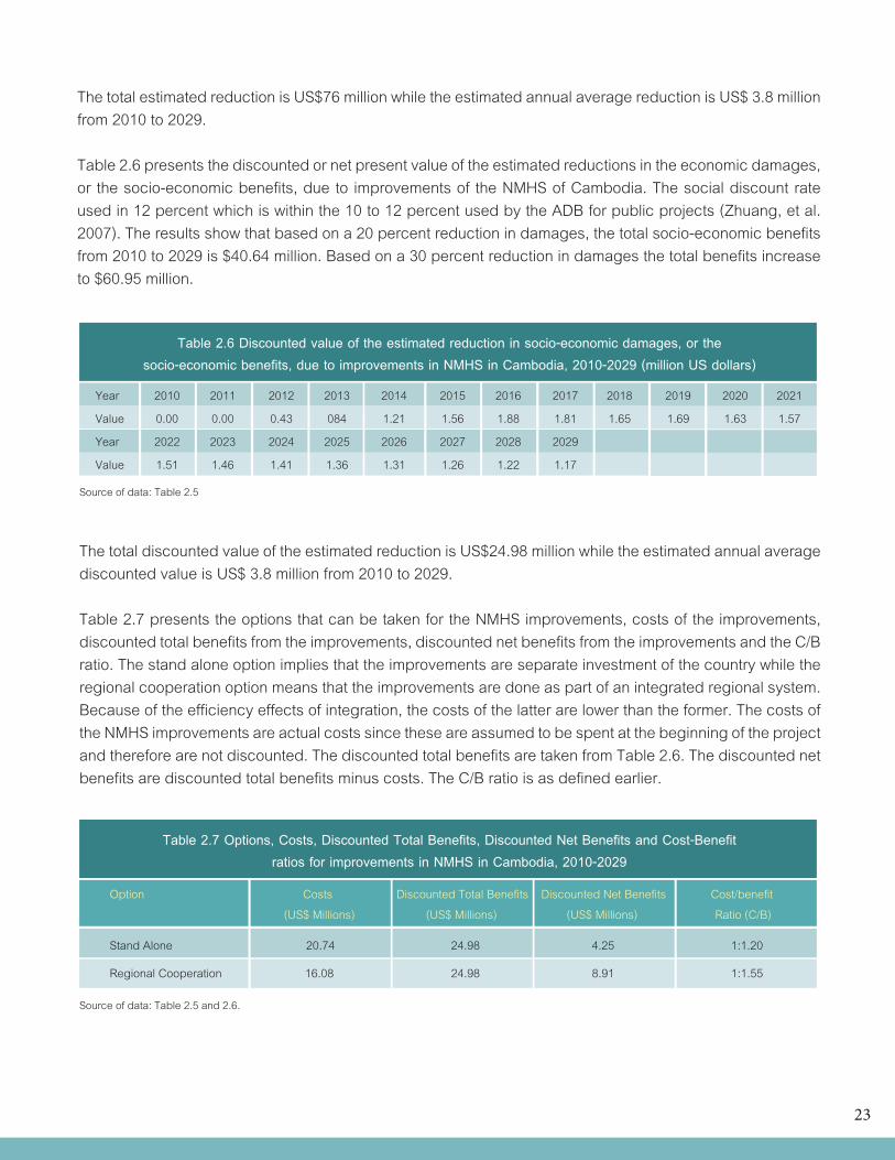
For the stand alone option, the results of the computations show that using a 10 percent reduction in damages as a measure of benefits, the total costs of NMHS improvements are $20.74 million, discounted total benefits are $24.98 million, discounted net benefits are $4.24 million and C/B ratio is 1:1.20.
For a regional integration option, the results of the computations show that using a 10 percent reduction in damages as a measure of benefits, the total costs of NMHS improvements are $16.08 million, discounted total benefits are $24.98 million, discounted net benefits are $8.90 million and C/B ratio is 1:1.55.
Option Total Costs Discounted Total Benefits Discounted Net Benefits Cost/benefit (Million US$) (Million US$) (Million US$) Ratio (C/B)
Stand alone 20.74 24.98 4.24 1:1.20
With regional cooperation 16.08 24.98 8.90 1:1.55
Table 1 Options, Costs, Discounted Total Benefits, Discounted Net Benefits and Cost-Benefit ratios for improvements in NMHS in Cambodia, 2010-2029
13
In retrospect, the following are the main findings of the computations done for Cambodia: • ThediscountednetbenefitsduetotheimprovementsintheNMHSofCambodia,basedevenonlyon the decrease in damages due to the improvements, are high and more than enough to pay for the cost of improvements; • TheC/BratiosbasedontheactualcostsofNMHSimprovementsandthediscountedvaluesofthe total benefits from the improvements, however, are inferior to the 1:7 ratio set by the WMO; • TheC/Bratioforthesystemwithregionalintegrationarebetterthantheratioforthestandalone system which implies that being more efficient the former system is also more desirable; and • TheC/BratioswouldimprovefurtheriftheindirectbenefitsoftheNMHSimprovements, productivity gains in the economy and the benefits beyond 2029 are included in the computation of benefits.
Environmental impacts of enhancement of the observation network
Automation of observation network does not produce harmful effects on the environment. The only activity that relates to this is the operation of upper-air observation and weather radars. The upper-air observation involves tracking of a pilot weather balloon in the atmosphere through an attached transmitter. Weather radars emit radioactive waves which is a threat to public health hence they must be located over remote and high areas.
Financing of the proposed project
Funds for the implementation of the project will be a big burden for DOM hence out sourcing is necessary. Foreign donors such as JICA, KOICA, USAID, AusAID or World Bank could be tapped. Assistance from neighboring countries who will be sharing the data and the products should also be sought.
14
The following data and information presented in the following sections are mainly taken from the World Factbook of the Central Intelligence Agency, USA.
Cambodia is generally populated by Khmers who are the descendants of the Angkor Empire that extended over much of Southeast Asia and reached its peak during the 10th to the 13th centuries. After the Japanese occupation in World War II, Cambodia gained full independence from France in 1953. In 1975, Communist Khmer Rouge forces took over Cambodia but were later driven out by Vietnamese invasion in 1978. About 13 years of civil war followed. In 1991, the Paris Peace Accords was negotiated which mandated democratic elections. Elections were held first held in 1993 followed by a second one in 1998 and a third one in 2003. These elections led to coalition governments which were initially stable but later on became more cohesive. In 2004, King Norodom Sihanouk abdicated the throne and his son, Prince Norodom Sihamoni succeeded. Local elections were held in Cambodia in 2007 while national elections were conducted in 2008 both of which were relatively peaceful compared to previous ones.
1.1 General Description
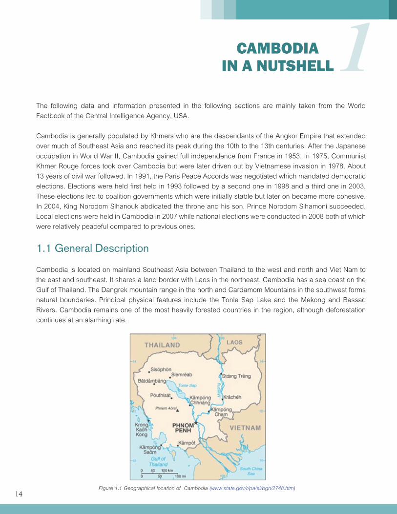
Cambodia is located on mainland Southeast Asia between Thailand to the west and north and Viet Nam to the east and southeast. It shares a land border with Laos in the northeast. Cambodia has a sea coast on the Gulf of Thailand. The Dangrek mountain range in the north and Cardamom Mountains in the southwest forms natural boundaries. Principal physical features include the Tonle Sap Lake and the Mekong and Bassac Rivers. Cambodia remains one of the most heavily forested countries in the region, although deforestation continues at an alarming rate.
1
CAMBODIA IN A NUTSHELL
Figure 1.1 Geographical location of Cambodia (www.state.gov/r/pa/ei/bgn/2748.htm)
15
Ninety percent of Cambodia’s population is ethnically Cambodian. Other ethnic groups include Chinese, Vietnamese, hill tribes, Cham, and Lao. Theravada Buddhism is the religion of 95% of the population; Islam, animism, and Christianity also are practiced. Khmer is the official language and is spoken by more than 95% of the population. Some French is still spoken in urban areas, and English is increasingly popular as a second language.
Geography and land Use •Location:SoutheasternAsia,borderingthe Gulf of Thailand, between Thailand, Vietnam, and Laos •Totalarea:181,035sqkm;landarea: 176,515 sq km; water area: 4,520 sq km •Totallandboundaries:2,572km •Coastline:443km •Maritimeclaims:territorialsea-12nm; contiguous zone-24 nm; exclusive economic zone-200 nm; continental shelf-200 nm •Climate:tropicalclimate;rainy,monsoon season (May to November); dry season (December to April); little seasonal temperature variation •Terrain:mostlylow,flatplains;mountainsin the southwest and north •Elevationextremes:lowestpoint-Gulfof Thailand; highest point-Phnom Oral 1,810 m •Landuse:arableland-20.44%;permanent crops-0.59%; other-78.97% (2005) •Irrigatedland:2,700sqkm(2003) •Totalrenewablewaterresources:476.1 cu km (1999) •Freshwaterwithdrawal(domestic/industrial/ agricultural): total-4.08 cu km/yr (1%/0%/ 98%); per capita-290 cu m/yr (2000) •Naturalhazards:monsoonalrains(Juneto November); flooding; occasional droughts •Environment-currentissues:illegallogging activities and strip mining have resulted in habitat loss and declining biodiversity; soil erosion; in rural areas, low or no access to potable water; declining fish stocks because of illegal fishing and overfishing
People •Nationality: Noun and adjective--Cambodian(s), Khmer. •Population:14,494,293 •Lifeexpectancyatbirth,totalpopulation: 62.1 years •Avg. annual growth rate (2008 census)1.54%. •Ethnicgroups:Khmer90%,Vietnamese5%, Chinese 1%, other 4%, small numbers of hill tribes, Cham, and Lao. •Languages:Khmer(official)95%,French, English Literacy (definition: age 15 and over can read and write): total population-73.6% •Religions:TheravadaBuddhism95%;Islam; animism; Christian. •Education:Yearscompulsory--nineyears. Enrolment--primary school, 94.4%; grades 7 to 9, 33.9%; grades 10 to 12, 16.4%; and tertiary, 2.8%. Completion rates--primary school, 85.58%; lower secondary school, 49.05%; upper secondary school, 20.58%; university, 6%. Literacy (total population over 15 that can read and write, 2007)--75.1% (male approx. 85%; female approx. 64%).
Government •Governmenttype:multipartydemocracy under a constitutional monarchy •Capital:PhnomPenh •Administrativedivisions:23provincesand one municipality (Phnom Penh) •Independence:November9,1953. •Constitution:September24,1993;amended March 6, 1999 and March 2, 2006. •Branches:Executive--KingSihamony(head of state since October 29, 2004), prime minister (Hun Sen since January 14, 1985), ten deputy prime ministers, 16 senior ministers, 26 ministers, 206 secretaries of state, and 205 undersecretaries of state. Legislative--National Assembly, consisting of 123 elected members; Senate, consisting of 61 members. Judicial--Supreme Court and lower courts.
16
Administrative subdivisions: 23 provinces and 1 capital municipality. •Politicalpartiesandleaders:Ruling parties--A coalition government of the Cambodian People’s Party (CPP), led by Samdech Chea Sim; and the National United Front for an Independent, Neutral, Peaceful, and Cooperative Cambodia (FUNCINPEC), led by Keo Puth Reasmey. Norodom Ranariddh Party representatives will serve out their term in parliament but announced in June 2009 their renaming as the Nationalist Party, which plans to join in a coalition with FUNCINPEC prior to 2012 commune elections. Opposition parties--The Sam Rainsy Party (SRP), led by Sam Rainsy; Human Rights Party, led by Kem Sokha.
Transnational issues •CambodiaandThailandlandborderdispute: Thailand accuses Cambodia of obstructing inclusion of Thai areas near Preah Vihear temple ruins, awarded to Cambodia by ICJ decision in 1962, as part of a planned UN World Heritage site; dispute over sovereignty over offshore islands with Vietnam
1.2 Economy-overview
From 2004 to 2007, the economy of Cambodia grew about 10% per year, driven largely by an expansion in the garment sector, construction, agriculture, and tourism. Growth dropped to below 7% in 2008 as a result of the global economic slowdown. With the January 2005 expiration of a WTO Agreement on Textiles and Clothing, Cambodian textile producers were forced to compete directly with lower-priced countries such as China, India, Viet Nam, and Bangladesh. The garment industry currently employs more than 320,000 people and contributes more than 85% of Cambodia’s exports. In 2005, exploitable oil deposits were found beneath Cambodia’s territorial waters, representing a new revenue stream for the government if commer-
cial extraction begins. Mining also is attracting significant investor interest, particularly in the northern parts of the country. Rubber exports declined more than 15% in 2008 due to falling world market prices. The tourism industry has continued to grow rapidly, with foreign arrivals exceeding 2 million per year in 2007-08. The global financial crisis is weakening demand for Cambodian exports, and construction is declining due to a shortage of credit.
The GDP growth performance of the country significantly decreased from 10.2 percent in 2007 to 5.2 percent in 2008 which was directly attributable to the prevailing global financial crisis. Other economic indicators are as follows:
Gross Domestic Product •GDP(purchasingpowerparity):$27.92 billion (2009 est.) •GDP(officialexchangerate):$10.9billion (2009 est.) •GDP–growth:-1.5%(2009est.) •GDP-percapita(PPP):$1,900(2009est.) •GDP-compositionbysector - agriculture: 29% - industry: 30% - services: 41% (2007 est.) •Budget: - revenues: $1.186 billion - expenditures: $1.748 billion (2009 est.)
Labor market •Laborforce:8.6million(2008est.) •Laborforce-byoccupation - agriculture: 75% - industry: NA% - services: NA% (2004 est.) •Unemploymentrate:3.5%(2007est.) •Populationbelowpovertyline:35%(2004) •Agriculture-products:rice,rubber,corn, vegetables, cashews, tapioca, silk •Industries:tourism,garments,construction, rice milling, fishing, wood and wood products, rubber, cement, gem mining, textiles •Industrialproductiongrowthrate:-6.5% (2009 est.)
17
Energy •Electricity - production: 1.273 billion kWh (2007 est.) - consumption: 1.272 billion kWh (2007 est.) - exports: 0 kWh (2008 est.) - imports: 167 million kWh (2007 est.) •Oil - production: 0 bbl/day (2008 est.) - consumption: 4,000 bbl/day (2008 est.) - proved reserves: 0 bbl (1 January 2009 est.) •Naturalgas - production: 0 cu m (2008 est.) - consumption: 0 cu m (2008 est.) - exports: 0 cu m (2008 est.) - imports: 0 cu m (2008 est. - proved reserves: 0 cu m (1 January 2009 est.)
Exports and imports •Exports-commodities:clothing,timber, rubber, rice, fish, tobacco, footwear •Exports–partners:US54.5%,Germany 7.7%, Canada 5.9%, UK 5.5%, Vietnam 4.5% (2008) •Imports–commodities:petroleumproducts, cigarettes, gold, construction materials, machinery, motor vehicles, pharmaceutical products •Imports–partners:Thailand27.1%,Vietnam 19.2%, China 14.7%, Hong Kong 8.2%, Singapore 7%, Taiwan 5.6% (2008) •Naturalresources:oilandgas,timber, gemstones, iron ore, manganese, phosphates, hydropower potential
Reserve, Debt, Aid •Reservesofforeignexchangeandgold: $2.951 billion (31 December 2009 est.) •Debt-external:$4.157billion (31 December 2009 est.)
Communications •Telephones-mainlinesinuse:45,100(2008) •Telephones-mobilecellular:4.237 million (2008)
•Radiobroadcaststations:AM1,FM50, shortwave NA (2008) •Televisionbroadcaststations:9(including 2 TV relay stations with French and Vietnamese broadcasts); excludes 18 regional relay stations (2009) •Internethosts:2,480(2009) •Internetusers:74,000(2008)
Transportation •Airports-withpavedrunways - total: 6 - 2,438 to 3,047 m: 3 - 1,524 to 2,437 m: 2 - 914 to 1,523 m: 1 (2009) •Airports-withunpavedrunways - total: 11 - 1,524 to 2,437 m: 1 - 914 to 1,523 m: 9 - under 914 m: 1 (2009) •Heliports:1(2009) •Railways,total:602km - narrow gauge: 8,529 km 1.067-m gauge (565 km electrified) (2008) •Roadways:38,093km - paved: 2,977 km - unpaved: 35,116 km (2007) •Waterways:2,400km(mainlyonMekong River) (2008) •Merchantmarine:total–626;bytype:bulk carrier 41, cargo 530, carrier 3, chemical tanker 10, container 8, passenger/cargo 6, petroleum tanker 11, refrigerated cargo 15, roll on/roll off 1, vehicle carrier 1; foreign-owned: 467 (Canada 2, China 193, Cyprus 7, Egypt 13, Gabon 1, Greece 3, Hong Kong 8, Indonesia 2, Japan 1, South Korea 22, Latvia 1, Lebanon 8, Netherlands 1, Romania 1, Russia 83, Singapore 4, Syria 48, Taiwan 1, Turkey 26, Ukraine 34, UAE 2, US 6) (2008) •Portsandterminals:PhnomPenh, Kampong Saom (Sihanoukville)
18
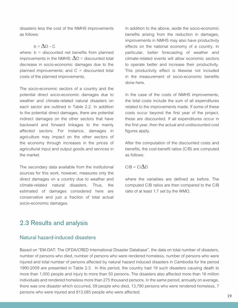
2.1 Weather and climate-dependent economic sectors Of the weather and climate-dependent economic sectors of Cambodia, manufacturing and agriculture have been the most dominant contributors to the national economy. In 2007, these sectors contributed 20.5 percent and 18.1 percent to the GDP respectively (Table 2.1). In totality the weather and climate-dependent economic sectors contributed 65.4 percent to the GDP in the same year. Because of this large contribution, improvements in the NMHS that would reduce the damages due to weather and climate-related natural disasters will have significant impacts on the overall economy.
2
SOCIO-ECONOMIC BENEFITS OF HYDRO-METEOROLOGICAL
SERVICES
Table 2.1 Percent share of value added by weather and climate-dependent economic sector to Gross Domestic Product at 1990 constant prices of the Cambodia, 2000-2007
Sector 2000 2001 2002 2003 2004 2005 2006 2007
Agriculture, hunting and related service activities Forestry, logging and related service activities
FishingMining and quarryingManufacturingElectricity, gas and water supply
ConstructionHotels and restaurants
Transport storage and communication
Total
21.7 20.7 18.7 20.2 18.2 19.5 18.7 18.1
3.5 3.2 2.9 2.6 2.3 2.2 2.1 1.9
10.8 10.5 9.9 9.3 8.3 7.7 7.3 6.60.2 0.2 0.3 0.3 0.4 0.4 0.4 0.4
16.0 17.1 18.3 18.9 20.2 19.6 20.8 20.5
0.4 0.5 0.5 0.5 0.5 0.5 0.6 0.6
5.2 4.7 5.6 5.8 5.9 6.4 6.9 6.7
3.7 4.2 4.7 3.6 4.0 4.3 4.4 4.4
6.6 7.1 7.1 6.8 6.7 6.8 6.2 6.1
68.1 68.2 67.9 67.9 66.4 67.3 67.3 65.4
Source: United Nations Statistics Division. Retrieved from http://data.un.org/Data.aspx?d=SNA&f=group_code%3a202
2.2 Methodology for computing socio-economic benefits The methodology employed here for computing the potential socio-economic benefits from planned improvements in the NMHS of a country is based on secondary data available from institutional sources. These secondary data were enhanced by informed assumptions provided by institutional key informants.
The monetized net socio-economic benefits from planned improvements in the NMHS of a country are defined as the monetized total decrease in socio-economic damages due to weather and climate-related natural
19
disasters less the cost of the NMHS improvements as follows:
b = ∆D–Cwhere: b = discounted net benefits from planned improvements in the NMHS; ∆D = discounted total decrease in socio-economic damages due to the planned improvements; and C = discounted total costs of the planned improvements.
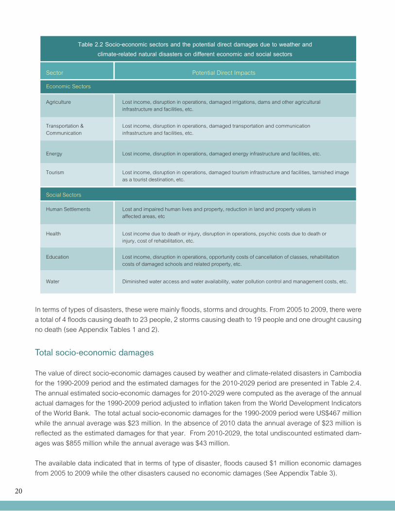
The socio-economic sectors of a country and the potential direct socio-economic damages due to weather and climate-related natural disasters on each sector are outlined in Table 2.2. In addition to the potential direct damages, there are potential indirect damages on the other sectors that have backward and forward linkages to the mainly affected sectors. For instance, damages in agriculture may impact on the other sectors of the economy through increases in the prices of agricultural input and output goods and services in the market.
The secondary data available from the institutional sources for this work, however, measures only the direct damages on a country due to weather and climate-related natural disasters. Thus, the estimated of damages considered here are conservative and just a fraction of total actual socio-economic damages.
In addition to the above, aside the socio-economic benefits arising from the reduction in damages, improvements in NMHS may also have productivity effects on the national economy of a country. In particular, better forecasting of weather and climate-related events will allow economic sectors to operate better and increase their productivity. This productivity effect is likewise not included in the measurement of socio-economic benefits done here.
In the case of the costs of NMHS improvements, the total costs include the sum of all expenditures related to the improvements made. If some of these costs occur beyond the first year of the project, these are discounted. If all expenditures occur in the first year, then the actual and undiscounted cost figures apply.
After the computation of the discounted costs and benefits, the cost-benefit ratios (C/B) are computed as follows: C/B = C/∆D
where the variables are defined as before. The computed C/B ratios are then compared to the C/B ratio of at least 1:7 set by the WMO.
2.3 Results and analysis
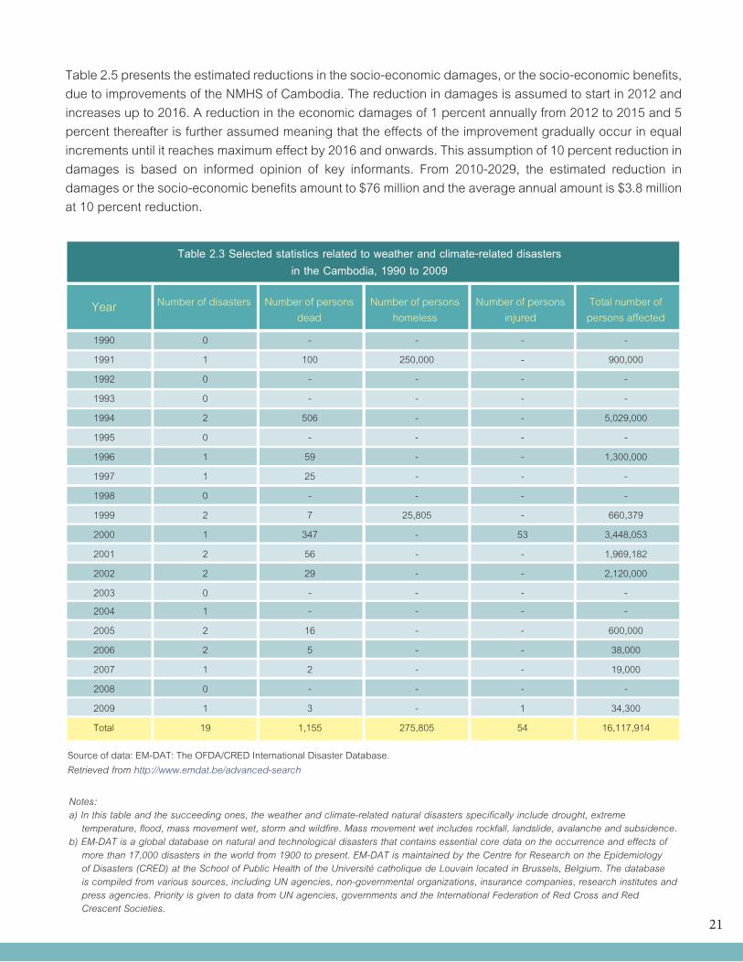
Natural hazard-induced disasters Based on “EM-DAT: The OFDA/CRED International Disaster Database”, the data on total number of disasters, number of persons who died, number of persons who were rendered homeless, number of persons who were injured and total number of persons affected by natural hazard induced disasters in Cambodia for the period 1990-2009 are presented in Table 2.3. In this period, the country had 19 such disasters causing death to more than 1,000 people and injury to more than 50 persons. The disasters also affected more than 16 million individuals and rendered homeless more than 275 thousand persons. In the same period, annually on average, there was one disaster which occurred, 59 people who died, 13,790 persons who were rendered homeless, 7 persons who were injured and 813,085 people who were affected.
20
Table 2.2 Socio-economic sectors and the potential direct damages due to weather and climate-related natural disasters on different economic and social sectors
Sector Potential Direct Impacts
Economic Sectors
Agriculture Lost income, disruption in operations, damaged irrigations, dams and other agricultural infrastructure and facilities, etc.
Transportation & Lost income, disruption in operations, damaged transportation and communication Communication infrastructure and facilities, etc.
Energy Lost income, disruption in operations, damaged energy infrastructure and facilities, etc.
Tourism Lost income, disruption in operations, damaged tourism infrastructure and facilities, tarnished image as a tourist destination, etc.
Social Sectors
Human Settlements Lost and impaired human lives and property, reduction in land and property values in affected areas, etc
Health Lost income due to death or injury, disruption in operations, psychic costs due to death or injury, cost of rehabilitation, etc.
Education Lost income, disruption in operations, opportunity costs of cancellation of classes, rehabilitation costs of damaged schools and related property, etc.
Water Diminished water access and water availability, water pollution control and management costs, etc.
In terms of types of disasters, these were mainly floods, storms and droughts. From 2005 to 2009, there were a total of 4 floods causing death to 23 people, 2 storms causing death to 19 people and one drought causing no death (see Appendix Tables 1 and 2).
Total socio-economic damages
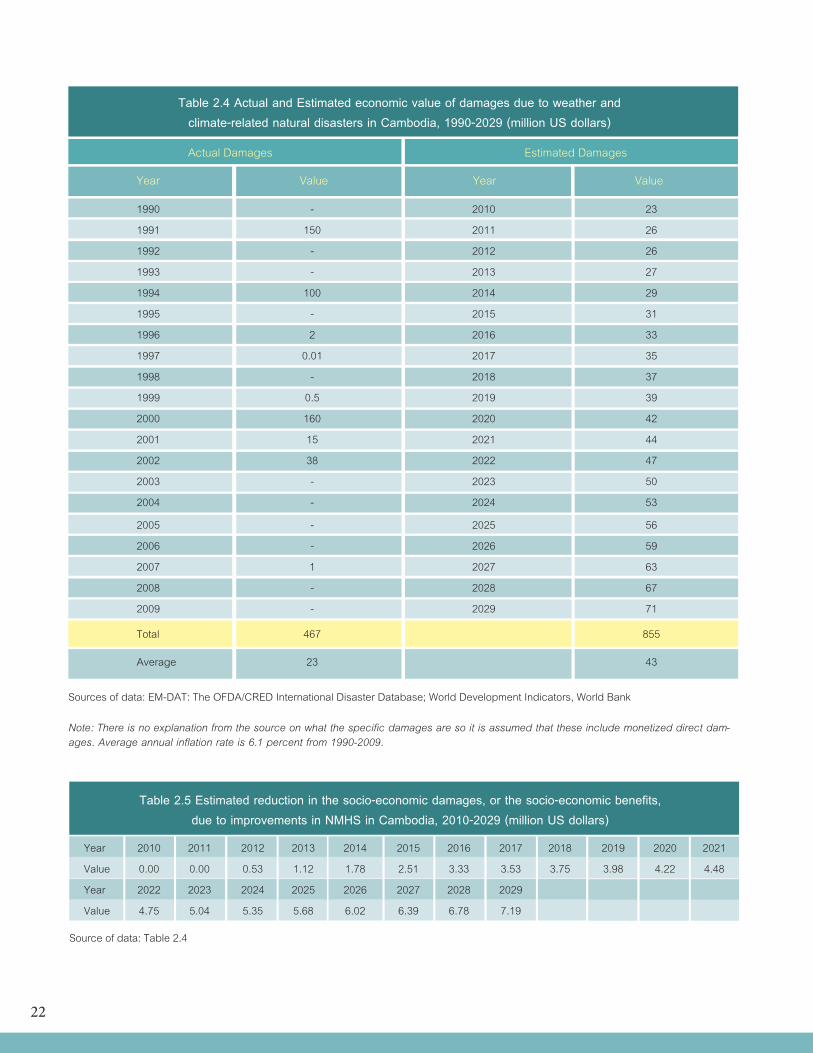
The value of direct socio-economic damages caused by weather and climate-related disasters in Cambodia for the 1990-2009 period and the estimated damages for the 2010-2029 period are presented in Table 2.4. The annual estimated socio-economic damages for 2010-2029 were computed as the average of the annual actual damages for the 1990-2009 period adjusted to inflation taken from the World Development Indicators of the World Bank. The total actual socio-economic damages for the 1990-2009 period were US$467 million while the annual average was $23 million. In the absence of 2010 data the annual average of $23 million is reflected as the estimated damages for that year. From 2010-2029, the total undiscounted estimated dam-ages was $855 million while the annual average was $43 million.
The available data indicated that in terms of type of disaster, floods caused $1 million economic damages from 2005 to 2009 while the other disasters caused no economic damages (See Appendix Table 3).
21
Table 2.5 presents the estimated reductions in the socio-economic damages, or the socio-economic benefits, due to improvements of the NMHS of Cambodia. The reduction in damages is assumed to start in 2012 and increases up to 2016. A reduction in the economic damages of 1 percent annually from 2012 to 2015 and 5 percent thereafter is further assumed meaning that the effects of the improvement gradually occur in equal increments until it reaches maximum effect by 2016 and onwards. This assumption of 10 percent reduction in damages is based on informed opinion of key informants. From 2010-2029, the estimated reduction in damages or the socio-economic benefits amount to $76 million and the average annual amount is $3.8 million at 10 percent reduction.
Table 2.3 Selected statistics related to weather and climate-related disasters in the Cambodia, 1990 to 2009
Year Number of disasters Number of persons dead
Number of persons homeless
Number of persons injured
Total number of persons affected
1990 0 - - - -
1991 1 100 250,000 - 900,000
1992 0 - - - -
1993 0 - - - -
1994 2 506 - - 5,029,000
1995 0 - - - -
1996 1 59 - - 1,300,000
1997 1 25 - - -
1998 0 - - - -
1999 2 7 25,805 - 660,379
2000 1 347 - 53 3,448,053
2001 2 56 - - 1,969,182
2002 2 29 - - 2,120,000
2003 0 - - - -
2004 1 - - - -
2005 2 16 - - 600,000
2006 2 5 - - 38,000
2007 1 2 - - 19,000
2008 0 - - - -
2009 1 3 - 1 34,300
Total 19 1,155 275,805 54 16,117,914
Source of data: EM-DAT: The OFDA/CRED International Disaster Database. Retrieved from http://www.emdat.be/advanced-search
Notes: a) In this table and the succeeding ones, the weather and climate-related natural disasters specifically include drought, extreme temperature, flood, mass movement wet, storm and wildfire. Mass movement wet includes rockfall, landslide, avalanche and subsidence. b) EM-DAT is a global database on natural and technological disasters that contains essential core data on the occurrence and effects of more than 17,000 disasters in the world from 1900 to present. EM-DAT is maintained by the Centre for Research on the Epidemiology of Disasters (CRED) at the School of Public Health of the Université catholique de Louvain located in Brussels, Belgium. The database is compiled from various sources, including UN agencies, non-governmental organizations, insurance companies, research institutes and press agencies. Priority is given to data from UN agencies, governments and the International Federation of Red Cross and Red Crescent Societies.
22
Table 2.4 Actual and Estimated economic value of damages due to weather and climate-related natural disasters in Cambodia, 1990-2029 (million US dollars)
Actual Damages Estimated Damages
Year Value Year Value
1990 - 2010 23
1991 150 2011 26
1992 - 2012 26
1993 - 2013 27
1994 100 2014 29
1995 - 2015 31
1996 2 2016 33
1997 0.01 2017 35
1998 - 2018 37
1999 0.5 2019 39
2000 160 2020 42
2001 15 2021 44
2002 38 2022 47
2003 - 2023 50
2004 - 2024 53
2005 - 2025 56
2006 - 2026 59
2007 1 2027 63
2008 - 2028 67
2009 - 2029 71
Total 467 855
Average 23 43
Sources of data: EM-DAT: The OFDA/CRED International Disaster Database; World Development Indicators, World Bank
Note: There is no explanation from the source on what the specific damages are so it is assumed that these include monetized direct dam-ages. Average annual inflation rate is 6.1 percent from 1990-2009.
Table 2.5 Estimated reduction in the socio-economic damages, or the socio-economic benefits, due to improvements in NMHS in Cambodia, 2010-2029 (million US dollars)
Year 2010 2011 2012 2013 2014 2015 2016 2017 2018 2019 2020 2021
Value 0.00 0.00 0.53 1.12 1.78 2.51 3.33 3.53 3.75 3.98 4.22 4.48
Year 2022 2023 2024 2025 2026 2027 2028 2029
Value 4.75 5.04 5.35 5.68 6.02 6.39 6.78 7.19
Source of data: Table 2.4
23
The total estimated reduction is US$76 million while the estimated annual average reduction is US$ 3.8 million from 2010 to 2029.
Table 2.6 presents the discounted or net present value of the estimated reductions in the economic damages, or the socio-economic benefits, due to improvements of the NMHS of Cambodia. The social discount rate used in 12 percent which is within the 10 to 12 percent used by the ADB for public projects (Zhuang, et al. 2007). The results show that based on a 20 percent reduction in damages, the total socio-economic benefits from 2010 to 2029 is $40.64 million. Based on a 30 percent reduction in damages the total benefits increase to $60.95 million.
Table 2.6 Discounted value of the estimated reduction in socio-economic damages, or the socio-economic benefits, due to improvements in NMHS in Cambodia, 2010-2029 (million US dollars)
Year 2010 2011 2012 2013 2014 2015 2016 2017 2018 2019 2020 2021
Value 0.00 0.00 0.43 084 1.21 1.56 1.88 1.81 1.65 1.69 1.63 1.57
Year 2022 2023 2024 2025 2026 2027 2028 2029
Value 1.51 1.46 1.41 1.36 1.31 1.26 1.22 1.17
Source of data: Table 2.5
The total discounted value of the estimated reduction is US$24.98 million while the estimated annual average discounted value is US$ 3.8 million from 2010 to 2029.
Table 2.7 presents the options that can be taken for the NMHS improvements, costs of the improvements, discounted total benefits from the improvements, discounted net benefits from the improvements and the C/B ratio. The stand alone option implies that the improvements are separate investment of the country while the regional cooperation option means that the improvements are done as part of an integrated regional system. Because of the efficiency effects of integration, the costs of the latter are lower than the former. The costs of the NMHS improvements are actual costs since these are assumed to be spent at the beginning of the project and therefore are not discounted. The discounted total benefits are taken from Table 2.6. The discounted net benefits are discounted total benefits minus costs. The C/B ratio is as defined earlier.
Option Costs Discounted Total Benefits Discounted Net Benefits Cost/benefit (US$ Millions) (US$ Millions) (US$ Millions) Ratio (C/B)
Stand Alone 20.74 24.98 4.25 1:1.20
Regional Cooperation 16.08 24.98 8.91 1:1.55
Table 2.7 Options, Costs, Discounted Total Benefits, Discounted Net Benefits and Cost-Benefit ratios for improvements in NMHS in Cambodia, 2010-2029
Source of data: Table 2.5 and 2.6.
24
For the stand alone system, the total cost of NMHS improvements is $20.74 million while the discounted total benefits due to NMHS improvements is $24.98 million benefits (Table 2.7). Therefore, the discounted net benefits are $4.25 million while the C/B ratio is 1:1.20.
For a system based on regional cooperation, the total cost of NMHS improvement is $16.08 million which is lower than the cost of a standalone system. Again, the discounted total benefits due to the NMHS improvements are $24.98 million. Therefore, the discounted net benefits are $8.91 million and the C/B ratio is 1:1.55.
It is noted that the mentioned C/B ratios generated above for both of the two systems considered are inferior to the C/B ratios computed by other studies on benefits of meteorological and hydrological services. These studies derived C/B ratios which are better than the WMO minimum accepted ratio of 1:7 (Hautala et al., Tammelin 2007, Leviakangas et al. 2007). It should also be noted that the computed C/B takes into consideration only direct benefits from reduced disaster losses. In reality there are indirect benefits such as from improved decision making in water resource management and climate change etc.
Sectoral damages
The physical data of the damages for the various social and economic sectors of Cambodia, including social, agriculture and infrastructure for the period 2000 to 2009 are presented in Appendix Table 4. It is shown that the physical damages are pervasive and have great impacts on the country and popula-tion. There are no available data, however, on the
economic value of these sectoral physical damages that can be used to compute the expected benefits from NMHS improvements by sector. There are also no data on the estimated total value of damages in Cambodia over the years.
Sectorally, the main qualitative benefits and impacts of meteorological and hydrological information ser-vices in general level for a given country are pre-sented in Appendix Table 5.
2.4 Summary of findings
In retrospect, the following are the main findings of the computations done for Cambodia:
•Thediscountednetbenefitsduetothe improvements in the NMHS of Cambodia, based even only on the decrease in damages due to the improvements, are high and more than enough to pay for the cost of improvements; •TheC/Bratiosbasedontheactualcostsof NMHS improvements and the discounted values of the total benefits from the improvements, however, are inferior to the 1:7 ratio set by the WMO; •TheC/Bratioforthesystemwithregional integration are better than the ratio for the stand alone system which implies that being more efficient the former system is also more desirable; and •TheC/Bratioswouldimprovefurtherifthe indirect benefits of the NMHS improvements, productivity gains in the economy and the benefits beyond 2029 are included in the computation of benefits.
25
3.1 Agriculture and food production
The contribution of agriculture, hunting and related service activities to the GDP of Cambodia in 2007 was 18.1 percent (Table 2.1). Cambodia has a predominantly rural population, with some 85 per cent of people living in rural areas. Half of its work force is employed in agriculture. Despite most farming activity being at a subsistence level, Cambodian rice production has seen large increases over the past decade-a result of the introduction of new varieties. Output of other crops, meanwhile, has been fairly static. Not surprisingly, use of mechanisation is limited, but draft animals are commonly used both for cultivation and transporting produce.
Access to land is one significant facto also impinging on the potential of Cambodia for agricultural development, particularly among the poorest. A lack of credit systems in rural areas makes breaking out of the cycle of subsistence production more difficult while limited access to market information and inadequate infrastructure and transport hinder the activities of those farmers who are in a position to produce commercially.
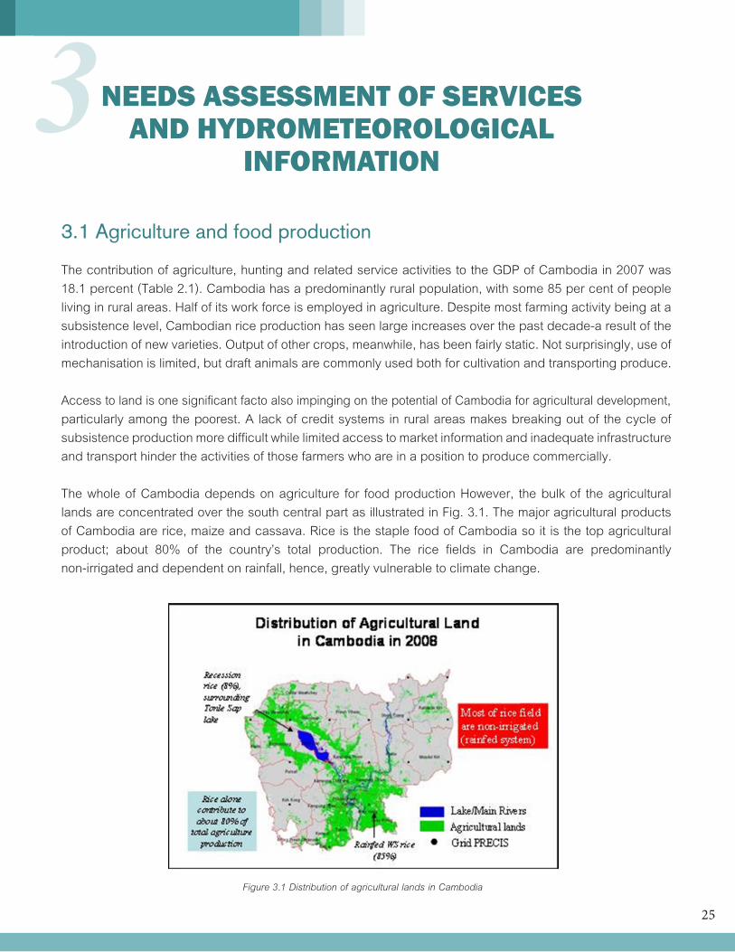
The whole of Cambodia depends on agriculture for food production However, the bulk of the agricultural lands are concentrated over the south central part as illustrated in Fig. 3.1. The major agricultural products of Cambodia are rice, maize and cassava. Rice is the staple food of Cambodia so it is the top agricultural product; about 80% of the country’s total production. The rice fields in Cambodia are predominantly non-irrigated and dependent on rainfall, hence, greatly vulnerable to climate change.
NEEDS ASSESSMENT OF SERVICES AND HYDROMETEOROLOGICAL
INFORMATION3
Figure 3.1 Distribution of agricultural lands in Cambodia
26
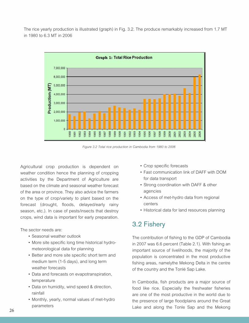
The rice yearly production is illustrated (graph) in Fig. 3.2. The produce remarkably increased from 1.7 MT in 1980 to 6.3 MT in 2006
Figure 3.2 Total rice production in Cambodia from 1980 to 2006
Agricultural crop production is dependent on weather condition hence the planning of cropping activities by the Department of Agriculture are based on the climate and seasonal weather forecast of the area or province. They also advice the farmers on the type of crop/variety to plant based on the forecast (drought, floods, delayed/early rainy season, etc.). In case of pests/insects that destroy crops, wind data is important for early preparation.
The sector needs are: •Seasonalweatheroutlook •Moresitespecificlongtimehistoricalhydro- meteorological data for planning •Betterandmoresitespecificshorttermand medium term (1-5 days), and long term weather forecasts •Dataandforecastsonevapotranspiration, temperature •Dataonhumidity,windspeed&direction, rainfall •Monthly,yearly,normalvaluesofmet-hydro parameters
•Cropspecificforecasts •FastcommunicationlinkofDAFFwithDOM for data transport •StrongcoordinationwithDAFF&other agencies •Accessofmet-hydrodatafromregional centers •Historicaldataforlandresourcesplanning
3.2 Fishery
The contribution of fishing to the GDP of Cambodia in 2007 was 6.6 percent (Table 2.1). With fishing an important source of livelihoods, the majority of the population is concentrated in the most productive fishing areas, namelythe Mekong Delta in the centre of the country and the Tonlé Sap Lake.
In Cambodia, fish products are a major source of food like rice. Especially the freshwater fisheries are one of the most productive in the world due to the presence of large floodplains around the Great Lake and along the Tonle Sap and the Mekong
27
Rivers. Marine fishery and aquaculture are small compared to the inland fishery.
Cambodia has a small coastline of 435 km. The marine fishing grounds are located on the eastern bank of the Gulf of Thailand. Marine fisheries were slowly developed compared to freshwater fisheries. The coastal zone statistics only report on the fishing effort (by boat and gear) for taxable gears which are largely confined to inshore waters. The offshore fishery is largely fished by international fleets of which there are no estimates of effort, catches or revenue collection.
The aquaculture sector is of minor significance to the fishery production of Cambodia. The wild fishery in Cambodia has been so productive that there has been little incentive for development of aquaculture.
The inland fisheries of Cambodia produce an estimated 295,000 – 420,000 tons of fish eachyear with an estimated value at landing of between US$150 m and US$200 m and a retail value of up to US$500 million. The total volume of seafood harvested is speculated to be 30,000 to 50,000 tons per year, valued at about US$30 million to US$50 million (US$1/kg of seafood on average).
Six million people or 50% of the population of Cambodia are employed full or part time in fisheries. The labor force involved in the marine fishery sector, including fishing, gathering, processing, and marketing and is estimated to be only 10 000 people (10% of the coastal inhabitants).
Needs: •1-5dayweatherforecasts •Windspeedanddirection •Windforecastsincludinglocalwind, •Thunderstormswithgusts •visibility •Waveheights •Waterlevels •Historicaldataforstrategy,policyand management planning
3.3 Forest industry
The contribution of forestry, logging and related service activities to the GDP of Cambodia in 2007 was 14 percent (Table 2.1). Parts of the country, particularly the southwest and the north and northeast, are heavily forested, but while in the mid-1960s, 75 per cent of the country was covered in rainforest, a survey in 1993 revealed that this had been reduced to 49 per cent. Logging is a problem in Cambodia and the strong demand for timber and stricter regulations in neighbouring countries mean that its forests continue to be exploited by foreign timber companies. Economic and mining land concessions have put extra pressure on forest resource of Cambodia; this can extend even into protected areas.
About three-fourths of Cambodia was forested in 1970, but by the early 21st century that portion had decreased to roughly half, with Cambodia carrying one of the highest deforestation rates in the world. The provinces bordering Thailand and Vietnam con-tinue to be logged by large companies to whom the government has granted concessions, as well as by smaller entrepreneurs, many of whom do not obtain official permits. Illegal logging is a persistent and serious problem despite efforts to curb it.
Needs: •Forest-meteorologicalobservationstations •Nearrealtimedataoncriticalparameters (incl. soil humidity) •Sitespecificweatherforecasts •Productionoftheforestfireindex •Numericalweatherforecastingmodelsto produce site specific parameters required to calculate the forest fire index •Modellingandforecastingofdispersion of smoke •Estimatesofbiomassproductionandits impacts on land use management •Studyintheimpactofclimatechangeonthe forest sector •Watershedmanagementandplanning

28
3.4 Water management
Cambodia has a unique hydrological system. The Mekong River and Lake Tonle Sap are connected by the Tonle Sap River which twice a year reverses its direction of flow. From July to the end of October, when the level of the Mekong is high, water flows into the Tonle Sap River, which fills Lake Tonle Sap, thereby increasing the size of the lake from 2,600 km2 to about 10,500 km2 at its maximum. The storage capacity of Lake Tonle Sap is estimated at 72 km3. In October, when the level of the Mekong decreases, the Tonle Sap River reverses its flow, and water flows from Lake Tonle Sap to the Mekong River and thence to the Mekong Delta.
About 86% of Cambodia's territory (156,000 km2) is included in the Mekong River basin, the remaining 14% draining directly towards the Gulf of Thailand.
Water and other related natural resources are essential elements in the interests of every level actors of the Mekong Region as they are the base of the macro- and microeconomics as well as human rights.
The Vision for Water Resources in Cambodia is: 1. Access for all to safe, adequate and affordable drinking water hygiene and sanitation; 2. Freedom for all from the threat of loss of life and livelihood as a result of floods and droughts; 3. Sufficient water where it is needed, to provide for food security, peoples livelihood and economic activity; and 4. A water environment that is unpolluted and support healthy fisheries and aquatic ecosystems.
However, the water management in Cambodia seems to be ecologically unsustainable as there is a growing competition of the resources and the decision-making is characterized by economical and personal interests. These features related to the interest show that water management in Cambodia is planned for the elite rather that the population as a whole.
Figure 3.3 Distribution of water utilization in Cambodia
29
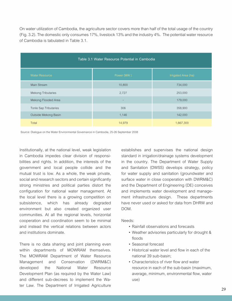
On water utilization of Cambodia, the agriculture sector covers more than half of the total usage of the country (Fig. 3.2). The domestic only consumes 17%, livestock 13% and the industry 4%. The potential water resource of Cambodia is tabulated in Table 3.1.
Table 3.1 Water Resource Potential in Cambodia
Water Resource Power (MW ) Irrigated Area (ha)
Main Stream 10,800 734,000
Mekong Tributaries 2,727 253,000
Mekong Flooded Area - 179,000
Tonle Sap Tributaries 306 358,900
Outside Mekong Basin 1,146 142,000
Total 14,979 1,667,300
Source: Dialogue on the Water Environmental Governance in Cambodia, 25-26 September 2008
Institutionally, at the national level, weak legislation in Cambodia impedes clear division of responsi-bilities and rights. In addition, the interests of the government and local people collide and the mutual trust is low. As a whole, the weak private, social and research sectors and certain significantly strong ministries and political parties distort the configuration for national water management. At the local level there is a growing competition on subsistence, which has already degraded environment but also created organized user communities. At all the regional levels, horizontal cooperation and coordination seem to be minimal and instead the vertical relations between actors and institutions dominate.
There is no data sharing and joint planning even within departments of MOWRAM themselves. The MOWRAM Department of Water Resource Management and Conservation (DWRM&C) developed the National Water Resource Development Plan (as required by the Water Law) and different sub-decrees to implement the Wa-ter Law. The Department of Irrigated Agriculture
establishes and supervises the national design standard in irrigation/drainage systems development in the country. The Department of Water Supply and Sanitation (DWSS) develops strategy, policy for water supply and sanitation (groundwater and surface water in close cooperation with DWRM&C) and the Department of Engineering (DE) conceives and implements water development and manage-ment infrastructure design. These departments have never used or asked for data from DHRW and DOM.
Needs: •Rainfallobservationsandforecasts •Weatheradvisoriesparticularlyfordrought& floods •Seasonalforecast •Historicalwaterlevelandflowineachofthe national 39 sub-basin; •Characteristicsofriverflowandwater resource in each of the sub-basin (maximum, average, minimum, environmental flow, water use)
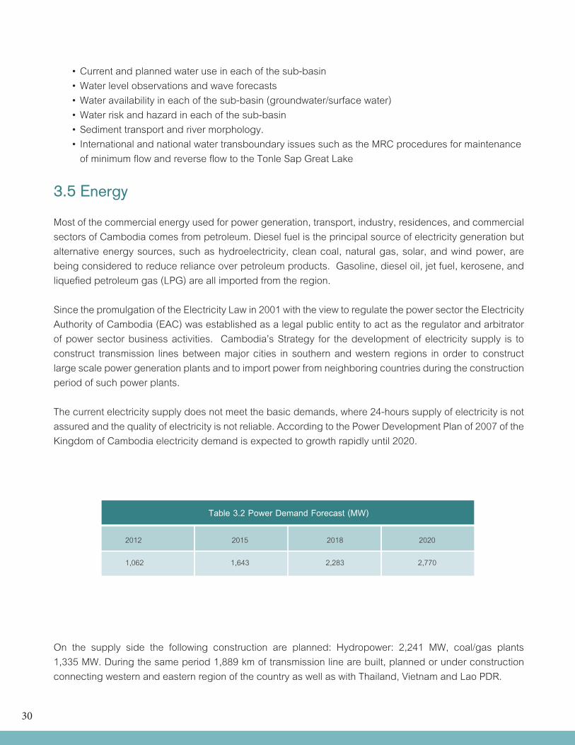
30
•Currentandplannedwateruseineachofthesub-basin •Waterlevelobservationsandwaveforecasts •Wateravailabilityineachofthesub-basin(groundwater/surfacewater) •Waterriskandhazardineachofthesub-basin •Sedimenttransportandrivermorphology. •InternationalandnationalwatertransboundaryissuessuchastheMRCproceduresformaintenance of minimum flow and reverse flow to the Tonle Sap Great Lake
3.5 Energy
Most of the commercial energy used for power generation, transport, industry, residences, and commercial sectors of Cambodia comes from petroleum. Diesel fuel is the principal source of electricity generation but alternative energy sources, such as hydroelectricity, clean coal, natural gas, solar, and wind power, are being considered to reduce reliance over petroleum products. Gasoline, diesel oil, jet fuel, kerosene, and liquefied petroleum gas (LPG) are all imported from the region.
Since the promulgation of the Electricity Law in 2001 with the view to regulate the power sector the Electricity Authority of Cambodia (EAC) was established as a legal public entity to act as the regulator and arbitrator of power sector business activities. Cambodia’s Strategy for the development of electricity supply is to construct transmission lines between major cities in southern and western regions in order to construct large scale power generation plants and to import power from neighboring countries during the construction period of such power plants.
The current electricity supply does not meet the basic demands, where 24-hours supply of electricity is not assured and the quality of electricity is not reliable. According to the Power Development Plan of 2007 of the Kingdom of Cambodia electricity demand is expected to growth rapidly until 2020.
Table 3.2 Power Demand Forecast (MW)
2012 2015 2018 2020
1,062 1,643 2,283 2,770
On the supply side the following construction are planned: Hydropower: 2,241 MW, coal/gas plants 1,335 MW. During the same period 1,889 km of transmission line are built, planned or under construction connecting western and eastern region of the country as well as with Thailand, Vietnam and Lao PDR.
31
The three main government institutions responsible for energy in Cambodia are listed: •MinistryofIndustry,MinesandEnergy (MIME)–responsibleforenergyplanning, policy and management •ElectricityAuthorityofCambodia (EAC)–responsibleforregulatingthe electricity industry (www.eac.gov.kh); and •ElectricityduCambodge (EdC)–governmentownedpowerutility responsible for the generation, transmission and distribution of power in nine areas of the country.
Sector needs: •Thunderstorm/lightningmonitoringand forecasting •Morereal-timeobservationsonprecipitation and water level •Moreaccuratesitespecificweatherforecasts for estimation of energy consumption and optimization of power production •Moreobservationsandmodelingofsolar radiation •Betterwinddataforassessmentinwind energy potential •0-24forecastsforwindpowerproduction •Seasonalforecasts •Nationalandinternationalcooperation •Strengtheningofexistingrivermonitoring network including their expansion to cover ungauged sub-basins
3.6 Transportation
Cambodia’s transportation system was greatly damaged during the war and is inadequately rehabilitated during peacetime. Cambodia received technical assistance and equipment from other countries i.e. France, Germany, Soviet Union, Australia, etc. for the transportation system; roads and railways network.
3.6.1 Land Transportation
Road transport in Cambodia has a total system length of 50,441 km, of which 2,115 km are one digit national, 3,372 km two digit national road, 6,467 km are 4 & 5 digits provincial road, and 38,527 km are rural road. Most rural roads are unpaved, but due to high maintenance cost, under the new government policy, they will be progressively paved.
Road traffic level are generally low though the number of vehicles has grown rapidly during the last decade, the total number of registered vehicles are 1,400, 000 in 2009. Cambodia has one of the highest road traffic dead rate 12.1/100,000 of population, especially mopeds and motocycles of which there were 680,002 in 2009 (IFR 2009). Cambodia also has one of the highest incidences of road accidents in Asia.
Cambodia’s rail network is currently being recon-structed as part of the Trans-Asian Railway project. Two rail lines exist, both originating in Phnom Penh with a total of about 641 kilometers of metre gauge single track. A third line is planned to connect Phnom Penh with Vietnam, the last missing link of the planned rail corridor between Singapore and the city of Kunming, China.
The rehabilitation Project is a large and complex project involving the following main track and components and related facilities: - Rehabilitation or reconstruction of 641 km of main line railway, comprising 385 km on the Northern line and 256 km of the Southern Line; - Rehabilitation of spur lines to the Green Trade Warehouse complex in the port of Phnom Penh and into Sihanoukville Port; - Construction of two new freight facilities: a railway container yard located inside Sihanoukville Port and a new freight and maintenance railway yard at Samrong.
32
The Northern Line was built to carry 15 tons axle load while the Southern Line was built to carry 20 tons axle load. Both lines are being rehabilitated to their respective axle load standards. The Southern Line is being converted from bolted track to continu-ously welded track. All bridges are being repaired and, where possible, upgraded to 20 tons axles load. Where bridge replacement is required, the new structures will be built for 20 ton axle load. The Government of Cambodia is considering additional upgrading of the northern line to 20 tons axle load to attain a homogenous network and match expected upgrades in Thailand. This would require additional financing.
Southern LineThe 110 km section between Samrong and Tuk Meas opened to traffic in October 2010. Commercial traffic between K-Cement’s factory in Tuk Meas and Phnom Penh (3,000 tons per week) started in the same month.The 146 km section between Touk Meas and Siha-noukville is expected to open traffic in late 2012.
Nothern LineThe 10 km section from Phnom Penh to Samrong was repaired and opened for low speed traffic in October 2010.The section is being upgraded to 20 tons axle load, which is expected to be completed in October 2012 to match opening of traffic to Sihanoukville.
The 21 km section from Samrong to Bat Doeung is rehabilitated and will open for traffic in June 2012.
The 48 km missing link between Poipet and the Thai border is being reconstructed to 20 tons axle load and is nearing completion. The first 42 km to Poipet will be completed in late 2012. Accrual reconnection to the railway network in Thailand depends on reconstruction of the last 6 km track of the border railway line from Aranya Phrathet Station in Thailand. This expected to be completed in 2013 or early 2014.
The 306 km section between Bat Doeung and Poipet is expected to be opened in several phases between 2014 or early 2015.
Spur LinesThe section from Sihanoukville Station into Sihnoukville Port, where the existing post track is being rehabilitated, will open in October 2012.
The section from Phnom Penh to the Green Trade Warehouse complex and Port of Phnom Penh will be upgraded to 20 tons axle load at low speed (15 km/hour). It is expected that this section will open to traffic in 2013.
Freight FacilitiesThe new container yard in Sihanoukville Port is expected to open in 2014. The timing is determined by the site for the new container yard, which is filled-pond that requires several years to settle before construction can start. In the meantime, existing tracks inside the port will be used for container operations.
The new freight maintenance facility in Samroang is expected to open in 2014, in step with opening of new container yard in Sihnoukville. In the interim, the exiting track in Phnom Penh Station will be used for container operations.The Ministry of Public Works and Transport (MPWT) need hydrometeorological data particularly for constructions of roads and bridges. Normally, the consultants request for these data from the DOM.
Needs: - Historical data of river flows and water level , wind speed and wind direction for road and water crossing design; - Historical annual rainfall data; - Short duration data for water crossing structure, drainage and sewage design; - Analysis on model results of different scenarios options for road development planning across flood plain;
33
- Weather forecasts especially during rainy season for road hazard warning - Mesoscale weather forecasts (convective activities like thunderstorms) - Rainfall monitoring and forecasts - Thunderstorm forecast - Seasonal weather outlook
3.6.2 Water Transportation
Cambodia has extensive inland waterways which were important historically in domestic trade. The Mekong and the Tonle Sap Rivers, their numerous tributaries, provided avenues of considerable length, including 3,700 kilometers navigable all year by craft drawing 0.6 meters and another 282 kilometers navigable to craft drawing 1.8 meters. In some areas, especially along the Mekong-Tonle Sap-Bassac river systems, the villages were completely dependent on waterways for commu-nications. Launches, junks, or barges transport passengers, rice, and other food in the absence of roads and railways.
Cambodia has two major ports, Phnom Penh Port and Sihanoukville Port, also known as Kampong Som, and five minor ones. Phnom Penh, located at the junction of the Bassac, the Mekong, and the Tonle Sap rivers, is the only river port capable of receiving 8,000-ton ships during the wet season and 5,000-ton ships during the dry season. It remains an important port for international commerce as well as for domestic communications.
On merchant marines, there are 626 ships (as of 2008) and 467 of which are foreign owned. These include 41 bulk carrier, 530 cargoes, 3 carriers, 10 chemical tankers, 6 passenger/cargo ships, 15 refrigerated cargoes, 11 petroleum tankers, 1 roll-on/off, and 1 vehicle carrier.
All the domestic ports suffer from insufficient or total absence of supporting infrastructure. There is presently no any reliable data on domestic cargo
movements on the river system. In 1994, it was estimated (in depth survey of boat operators) that about 40 to 50,000 tons could constitute the domestic cargo. The absence of reliable figures makes the task of designing and promoting river ports extremely difficult. The shallower Mekong, rather the Bassac River is declared international channel for navigation to Phnom Penh, Kampong Cham and Kratie, restricting vessel size. Small seagoing vessels (up to 4,500 DWT) are able to serve Phnom Penh in Cambodia Needs for information and services: - Rainfall and wind observations and forecasts - Water level monitoring and forecast - Seasonal forecast (for drought or flood) - Thunderstorm forecasts - Severe weather bulletins and typhoon forecast - Updated river chart (hydrographic atlas) - Sediment transport and information on river morphology
3.6.3 Air transportation
Cambodia possesses twenty-six airfields, eight airfields had permanent-surface runways. Phnom Penh International Airport is the largest airport. It also serves as the main base for the renascent Cambodian Air Force. Cambodia’s second largest airport is Siem Reap International Airport in the major tourist city of Siem Reap. Tourist traffic into Angkor International Airport saw passenger numbers overtake those of Phnom Penh in 2006, the airport now being the country’s busiest.
Cambodia also opened a new Soviet-built airfield at Ream, Sihanoukville International Airport in late 1983, which now is increasingly used linking Siha-noukville Siem Reap three flights per week. There is an additional secondary airport in Battambang.
Air Kampuchea was established in 1982 and flew only one route - from Phnom Penh to Ho Chi Minh
34
City in Viet Nam. In 1984 commercial air service was inaugurated between Phnom Penh and Ha Noi with the arrival at Hanoi International Airport of the Kampuchean Civil Aviation Company’s (AKASCHOR) first flight. Since then, there has been regular air service from Phnom Penh to Ha Noi, Vientiane, and Moscow.
The new national airline Cambodia Angkor Air was launched in 2009, with a large financial investment from Vietnam Airlines.
Needs: - Aerodrome forecasts - Real time meteorological data, i.e. winds, visibility, upper-air soundings - Seasonal weather forecasts - Mesoscale model forecasts - Severe weather bulletins
3.7 Construction
Construction is an important contributor to the economy of Cambodia. However, it is also vulnerable today due to global financial crisis and highly speculative spending in real estate. The construction sector was estimated to contribute about 7-8 percent a year to the country’s GDP.
However, inflation in Cambodia seems to be the challenge to the construction industry, the inflation rate (consumer price) was 4% (est.) in 2010 and 6% (est.) in 2011. The cost of investing in construction has grown rapidly. This price rise has also reduced the capability of investors to finance and finish construction projects. Moreover, even if projects are completed as planned, rising housing costs have the potential to drive buyers out of the market. Needs: •Climatologicaldataofmeteorological parameters (wind strength & prevailing direction, temperature, rainfall, humidity, etc.) in specific locations for building design and constructions
•Accuratesitespecificweatherforecast (precipitation, wind, temperature, lightning,..): 1 day, nowcasting •Meteorologicalmeasurementbasedload factors (wind, snow, water,..) for a renewed Regulations for Construction •Intensitiesofprecipitationforplanningof drainage system •Infuture:mesoscaleandmicroscaledataon solar radiation on inclined surfaces, local wind, temperature chill factor for planning and site purposes of buildings •Improvedcustomerspecifieddissemination of information
3.8 Land use and planning
Cambodia faces serious problems concerning land issues and diminishing natural resources. The concession system is a major source of land conflict as concessions deprive some of the local population of the basic resources needed for their livelihood, thus keeping them from achieving long term, sustainable development. This is one of the main reasons behind rural urban migration.
There is uncontrolled growth of settlements in the urban centres of Cambodia, along with insufficient physical and social infrastructure in newly built up areas. Also large scale construction along na-tional roads and along the national borders withoutconsidering regional development objectives are only some of the issues in land use and planning that have to deal with. Encroachment of flood plains for urban expansion and agricultural use threatens valuable wetlands resources and increase flood risks to surrounding areas affecting principally poor communities in surrounding suburb.
Legal and institutional frameworks for land management already exist in Cambodia, but implementation seems to be difficult due to struc-tural deficits in the Cambodian Planning system. There are no environmental or ecological planning
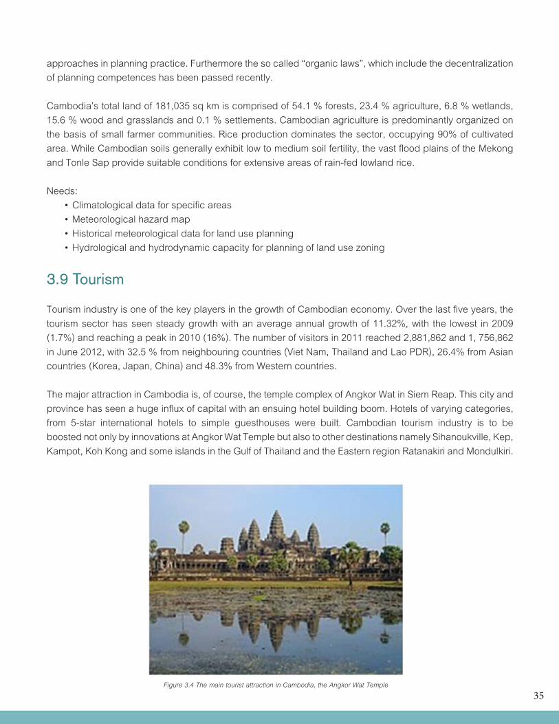
35
approaches in planning practice. Furthermore the so called “organic laws”, which include the decentralization of planning competences has been passed recently.
Cambodia’s total land of 181,035 sq km is comprised of 54.1 % forests, 23.4 % agriculture, 6.8 % wetlands, 15.6 % wood and grasslands and 0.1 % settlements. Cambodian agriculture is predominantly organized on the basis of small farmer communities. Rice production dominates the sector, occupying 90% of cultivated area. While Cambodian soils generally exhibit low to medium soil fertility, the vast flood plains of the Mekong and Tonle Sap provide suitable conditions for extensive areas of rain-fed lowland rice.
Needs: •Climatologicaldataforspecificareas •Meteorologicalhazardmap •Historicalmeteorologicaldataforlanduseplanning •Hydrologicalandhydrodynamiccapacityforplanningoflandusezoning
3.9 Tourism
Tourism industry is one of the key players in the growth of Cambodian economy. Over the last five years, the tourism sector has seen steady growth with an average annual growth of 11.32%, with the lowest in 2009 (1.7%) and reaching a peak in 2010 (16%). The number of visitors in 2011 reached 2,881,862 and 1, 756,862 in June 2012, with 32.5 % from neighbouring countries (Viet Nam, Thailand and Lao PDR), 26.4% from Asian countries (Korea, Japan, China) and 48.3% from Western countries.
The major attraction in Cambodia is, of course, the temple complex of Angkor Wat in Siem Reap. This city and province has seen a huge influx of capital with an ensuing hotel building boom. Hotels of varying categories, from 5-star international hotels to simple guesthouses were built. Cambodian tourism industry is to be boosted not only by innovations at Angkor Wat Temple but also to other destinations namely Sihanoukville, Kep, Kampot, Koh Kong and some islands in the Gulf of Thailand and the Eastern region Ratanakiri and Mondulkiri.
Figure 3.4 The main tourist attraction in Cambodia, the Angkor Wat Temple
36
Needs: •Weatherforecaststailoredfortouristresorts •Meteorologicaldataforenvironmentalimpact and risk assessment and management planning •Monthlyandseasonalforecasts •Extremeweatherphenomena •Riverwaterlevel,flow,groundwaterdatafor integrated watershed management particularly for Stung Siem Reap and Stung Sen river basins.
3.10 Insurance
Insurance industry in Cambodia is still at its devel-opment stage, and might be explained by the fol-lowing fact: - Sociologically Cambodians and business societies are not fully informed about the insurance system, even though the awareness has been notably improved in recent time; - Limited local expertise in the field; - Weak judicial system; - Limited number of compulsory insurance; and - Licensing requirement are generally considered high taking into account the size of the market, particularly for micro-insurance business.
The sector is still small but growing. It is managed by the Ministry of Economy and Finance, under the Financial Industry Department and InsuranceDivision. Regulatory and institutional frameworks have been established in 2000. Currently there are 6 insurance companies operating in the country with a Gross premium of US$20,012,933.64 in 2009 and 24,755,038.27 in 2010, a growth rate of 23.7%. Neither life insurance nor micro-insurance exists yet. Needs: •Historicaldata/climatologicalnormalforrisk assessment
•Localizedorsitespecificmeteorologicaldata for insurance claims due to weather disturbance •Meteorologicalandfloodshazardmaps
3.11 Health
Like many developing countries, Cambodia faces a range of vulnerabilities and risks, including traditional, modern and emerging health and environmental risks. These risks emanate from unsafe water and inadequate sanitation; unsafe food supplies, especially from street vendors; indoor air pollution and solid fuel use; as well as disease-vector transmission.
In Cambodia, 65% of the total population has sustainable access to an improved water source (80% in urban and 61% in rural areas) and only 28% to improved sanitation (62% in urban and 19% in rural areas) in 2006. Other environmental health hazards include bacteriological contamination of drinking water, the most important health-related concern; arsenic in groundwater, which poses a health threat in seven provinces, exposing around 2.24 million people; indoor and urban air pollution, which is a se-rious health threat due to almost 98% of the popula-tion using biomass fuels for cooking or heating; use of banned pesticides and fertilizers, which has the potential to contaminate food and water; and finally, the serious environmental health impacts from solid and hazardous wastes, including health care waste.
There are around half a million cases of malaria with 5-10,000 deaths per year in Cambodia. Incidence rates vary in different parts of the country. Malaria control is hampered by multiple drug resistance of Plasmodium falciparum, inaccessibility to the major vector, poor security in most malarias areas, and lack of resources. The control strategy emphasises improvement of clinical management and provision of prompt and accurate diagnosis in order to reduce morbidity and to prevent mortality. In addition health information and drug distribution systems are being
37
improved. The use of pyrethroid-treated mosquito nets and health education are being promoted. Particular attention is given to returning refugees as they settle into the country.
Climate is a major driving force behind malaria transmission and climate data are often used to account for the spatial, seasonal and inter-annual variation in malaria transmission.
Needs: •Dataandinformationonweatherrelated diseases •CoordinationbetweenDOM&Health agencies •Researchstudyonimpactsofweather changes on health •Floodanddroughtforecasts •Seasonalforecast
3.12 Environment
Cambodia has a deteriorating natural environment over the years brought about by a poorly managed pursuit of economic development and a rapidly increasing population. The major environmental issues in Cambodia include illegal logging activities throughout the country, and strip mining for gems in the western region along the border with Thailand and recent mining concession areas. These have resulted in habitat loss and declining biodiversity (in particular, destruction of mangrove swamps threatens natural fisheries, destruction of headwater in some sub-basins); soil erosion; in rural areas, most of the population does not have access to potable water; declining fish stocks because of illegal fishing and over fishing.
With regard to international agreements on environment, Cambodia is a party to a number of the United Nations Conventions: Biodiversity, Climate Change, the Kyoto Protocol, Desertification, Endangered Species, Hazardous Wastes, Marine
Life Conservation, Ozone Layer Protection, Ship Pollution, Tropical Timber 94, Wetlands, Whaling. In addition, the Law of the Sea has been signed but not ratified.
3.12.1 Water quality
In Cambodia, the following has been identified as potential causes of deterioration of water quality:a) waste from Residential Areas; b) waste from industries; c) waste from recreation areas; d) waste from agricultural activities; e) pollution from port activities and development; f) pollution from maritime activities; g) pollution from offshore development; h) effects from charcoal production; i) effects from illegal fishing; and j) pollution hotspots
Since 2005, RDI has been conducting groundwater surveying activities from province-to-province, collecting samples and analyzing them in our laboratory. Over 7,000 wells have been tested in three priority provinces. Some areas have been found to have unsafe levels of Arsenic, Manganese, Fluoride, and Nitrate which can cause serious impacts to human health. Many areas have high Iron, Turbidity, Hardness, etc. which do not impact human health but may make the water taste and look bad, damage clothes, or cause rice to turn colour when cooked. Groundwater contamination is another risk due to lack of management regulation.
Needs: - Rainfall and water level monitoring - Regular rain water sampling analysis to check if polluted/acidic - Flood forecast - Development of water quality (surface and groundwater) information system
3.12.2 Air quality
In Cambodia, it is only in Phnom Penh where air quality is monitored regularly. All three monitoring points at Phnom Penh use passive tubes for 24
38
hours at the roadside and not ambient data; hence, the results obtained do not allow comparison to the WHO guidelines. The data indicate that the average annual levels of NO2 and SO2 are within the national standards of 100μg/m3 for NO2 and the United States Environmental Protection Agency’s (USEPA) standard of 80μg/m3 for SO2. Currently, Cambodia has no annual standards for SO2. Cambodia’s nation-al standards for TSP (100 μg/m3) are not met, and the contributions of mobile emissions and road dust re-suspension are of concern.
Respiratory diseases are among the leading causes of morbidity in Cambodia and PM has been tagged as the potential cause. Vehicle emissions, as well as road dust re-suspension, contribute to increasing amounts of TSP. Despite concerns about the possible impacts of air pollution in Cambodia, currently there is no information about studies that can support this claim.
Needs: - Upper air observations to enhance the data on meteorological conditions of dispersion - Dispersion modeling (traffic, industry, forest fires, dumping areas, ..) - Monitoring network for transboundary transportation of airborne pollutants - Monitoring of urban air quality - Mobile monitoring stations - National database for air quality measurements - Quality control and traceability of measurements to international standards - Forecasting and warnings of quality of air - Dissemination of information to the public - Environmental databank
3.13 Disaster Risk Reduction
The National Committee for Disaster Management (NCDM) was established by the Royal Government of Cambodia in 1995 not only to provide timely and effective emergency relief to victims of disasters but also to develop preventive measures to reduce loss of lives and property.
NCDM is a Ministerial level Agency, chaired by the Prime Minister that formed to assist the Royal Government in its Mission to lead the Disaster Management in the Kingdom of Cambodia. Its functions and responsibilities are as follows:
1. Manage data of disaster risk and develop report on the disaster situation; 2. Proposal on reserves of resources for Disaster intervention in Emergency Response; 3. Capacity Building and human resource development on disaster management; 4. Coordination in implementation of disaster management policies; 5. Exchange and sharing information; 6. Coordination and mobilization of resources for disaster response;
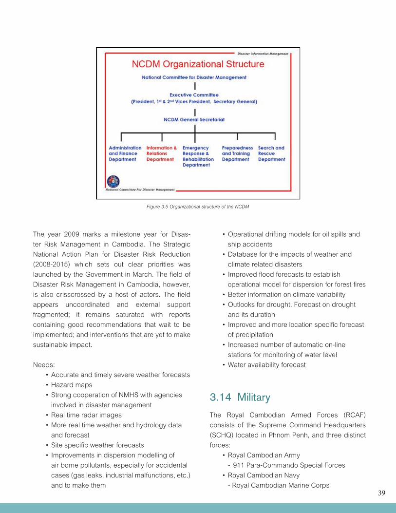
39
Figure 3.5 Organizational structure of the NCDM
The year 2009 marks a milestone year for Disas-ter Risk Management in Cambodia. The Strategic National Action Plan for Disaster Risk Reduction (2008-2015) which sets out clear priorities was launched by the Government in March. The field of Disaster Risk Management in Cambodia, however, is also crisscrossed by a host of actors. The fieldappears uncoordinated and external support fragmented; it remains saturated with reports containing good recommendations that wait to be implemented; and interventions that are yet to make sustainable impact.
Needs: •Accurateandtimelysevereweatherforecasts •Hazardmaps •StrongcooperationofNMHSwithagencies involved in disaster management •Realtimeradarimages •Morerealtimeweatherandhydrologydata and forecast •Sitespecificweatherforecasts •Improvementsindispersionmodellingof air borne pollutants, especially for accidental cases (gas leaks, industrial malfunctions, etc.) and to make them
•Operationaldriftingmodelsforoilspillsand ship accidents •Databasefortheimpactsofweatherand climate related disasters •Improvedfloodforecaststoestablish operational model for dispersion for forest fires •Betterinformationonclimatevariability •Outlooksfordrought.Forecastondrought and its duration •Improvedandmorelocationspecificforecast of precipitation •Increasednumberofautomaticon-line stations for monitoring of water level •Wateravailabilityforecast
3.14 Military The Royal Cambodian Armed Forces (RCAF) consists of the Supreme Command Headquarters (SCHQ) located in Phnom Penh, and three distinct forces: •RoyalCambodianArmy - 911 Para-Commando Special Forces •RoyalCambodianNavy - Royal Cambodian Marine Corps
40
•RoyalCambodianAirForce •RoyalGendarmerieofCambodia (Military Police)
The RCAF was created in 1993 by the merger of the Cambodian People’s Armed Forces and the two non communist resistance armies. At the time, there were also resistance forces opposing the Government comprising the Khmer Rouge and a separate royalist resistance movement (also known as the National United Army or NUA). The armed forces currently operate under the jurisdiction of theMinistry of National Defence.
The Royal Cambodian Army is the largest force with troops stationed in each province of the country. The Royal Cambodian Navy is the second largest force and operates at sea, along the Mekong and Bassac rivers and in the Tonle Sap Lake. The military police force numbers around 7,800 employees and runs parallel to the civilian policeforce. The military police have posts in every province and municipality across the country. The Royal Cambodian Air Force is the smallest of the three forces and has around 1,000 employees. The air force operates in every province with an airport. The Gendarmarie, or “Military Police”, is a para-military unit with about 7,000 soldiers deployed in all provinces. It is headquartered in Phnom Penh, with the unit’s chain of command through the Royal Cambodia Armed Force High Command. The Gendarmerie is under the direct supervision of a commander with an equivalent rank to Lieutenant-General. The military police headquarters are in Phnom Penh, and are responsible for monitoring all of the units of Gendarmerie as well as general training.
The Conscription Law of October 2006 requires all males between 18-30 years old to register for an 18-month military service obligation. The available manpower fit for service is: males between the age 16-49: 2,751,618 and females between the age 16-49: 2,835,807 (2010 est.). The Military expenditures of Cambodia is estimated at 3% of GDP (2005 est.)
Needs: •Weatheroutlookandimprovedforecast •Informationandforecastoncloudheight •Upperairobservations •Dopplerradardata/images(horizontaland vertical cross sections) •Goodcommunicationlink
3.15 Climate change
In Cambodia, the direct impact of climate change may be seen in the change in natural rainfall patterns in the country. Though incidences of flood and drought are common in Cambodia, global warming may increase the country’s wet season rainfall and decrease its dry season rainfall in addition to existing great spatial and temporal variability.
As an essentially agrarian country, the Kingdom of Cambodia is highly vulnerable to the impacts of climate change. Cambodia, like other agrarian economies, is especially vulnerable to weather-related disasters as more than 80 percent of its population is subsistence farmers. Adverse impacts include increased in frequencies and magnitude of flood and drought damages, reduction in crop yields, decrease water availability and increase in the number of people exposed to vector andwater-borne diseases. Based on data from the past five years, Cambodia’s paddy production was destroyed as much as 70 percent by floods, and 20 percent and 10 percent respectively by droughts and diseases.
Results showed that under the high emission scenarios, Dry Season rainfalls will decrease with high probability and Wet Season rainfall may increase but with lower probability than the Dry Season rainfall. This suggests that the onset of rainy season may delay in the future under this emission scenario. Moreover, Wet Season rainfall will decrease until 2025 and then increase again in 2050 and 2080. Similarly, for low emission scenarios, Dry Season rainfall will decrease but with lower
41
probability. However, Wet Season rainfall will increase in 2025 then decreases again in 2050 and 2080.
Available studies indicate the following impacts of climate change on the different sectors in Cambodia:
On AgricultureThe increase in future rainfall variability will have im-pacts on agriculture production: •Affectyieldvariability •Increasecropproductionlossduetothe increase in frequency and intensity of extreme climate events •Ricefarmingsystemmightbeexposedto higher flood and drought risks in the future •Increasefrequencyofcroppestanddiseases outbreak (emergence of new pests and diseases, etc)
On Forestry •Increasedprecipitationwouldincreasesoil erosion, which in turn would accelerate forest degradation •Basedonstudiesofneighboringcountries, forest productivity and some of species of Cambodia may change and disappear •Needtofurtherstudyontheimpactofclimate change on forest productivity and biodiversity
On Human Health: •Numberofmalariacasesisnegatively correlated with dry season rainfall, mean annual temperature and percent literate, and positively correlated with wet season rainfall. The Ministry of the Environment estimates that under changing climatic conditions Cambodia may experience increasing incidences of malaria, up 16 percent from its current rate
On Coastal Zone: •Risingseaswillincreasetheriskoflow-lying areas to flood. Koh Kong province will be the
most vulnerable to sea level rise •Coastalerosionwillincrease •Saltwaterintrusionwillincrease •Mangroveecosystemisthewidestarea that would be inundated •Coastalindustriesandeconomies,tourism and wildlife habitats would be seriously affected •Aone-metersealevelrisewouldsubmerge about 56% of the low lying coastal city of Koh Kong
Natural hazard-induced disasters have upset fragile ecosystems, which in turn have triggered other changes that have consequence in rising poverty and malnutrition of children.
Meanwhile, damage to infrastructure and land has compelled people to relocate, which has caused psychological disorders in many. This illustrates how vulnerable Cambodia is in facing the impact of climate change due to a lack of infrastructure and mechanisms to lessen the effects. With these direct and indirect impacts of climate change, different levels of impacts can be analyzed at the national, community and individual levels.
On the country level, with less agricultural activity and losses due to natural hazard and climate related disasters, Cambodia, which largely depends on the agricultural sector, will experience slow economic growth. In addition, poor and underdeveloped health infrastructure will aggravate the health problems and further burden the gov-ernment. On the community level, the livelihoods of many will be affected by disasters, which would not only adversely affect homes and properties, agricultural produce and health, but also community collaboration and trust when the economic downturn would lead to more social crimes. On the individual level, people will face with issues such as pollution and access to clean water. Depletion of natural resources and bad economic policies will discourage foreign direct investment, which otherwise provides employment to local people.
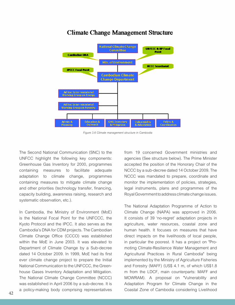
42
Figure 3.6 Climate management structure in Cambodia
The Second National Communication (SNC) to the UNFCC highlight the following key components: Greenhouse Gas Inventory for 2000, programmes containing measures to facilitate adequate adaptation to climate change, programmes containing measures to mitigate climate change and other priorities (technology transfer, financing, capacity building, awareness raising, research and systematic observation, etc.).
In Cambodia, the Ministry of Environment (MoE) is the National Focal Point for the UNFCCC, the Kyoto Protocol and the IPCC. It also serves as the Cambodia’s DNA for CDM projects. The Cambodian Climate Change Office (CCCO) was established within the MoE in June 2003. It was elevated to Department of Climate Change by a Sub-decree dated 14 October 2009. In 1999, MoE had its first ever climate change project to prepare the Initial National Communication to the UNFCCC, the Green-house Gases Inventory Adaptation and Mitigation. The National Climate Change Committee (NCCC) was established in April 2006 by a sub-decree. It is a policy-making body comprising representatives
from 19 concerned Government ministries and agencies (See structure below). The Prime Minister accepted the position of the Honorary Chair of the NCCC by a sub-decree dated 14 October 2009. The NCCC was mandated to prepare, coordinate and monitor the implementation of policies, strategies, legal instruments, plans and programmes of the Royal Government to address climate change issues.
The National Adaptation Programme of Action to Climate Change (NAPA) was approved in 2006. It consists of 39 ‘no-regret’ adaptation projects in agriculture, water resources, coastal zone and human health. It focuses on measures that have direct impacts on the livelihoods of local people, in particular the poorest. It has a project on "Pro-moting Climate-Resilience Water Management and Agricultural Practices in Rural Cambodia" being implemented by the Ministry of Agriculture Fisheries and Forestry (MAFF) (US$ 4.1 m, of which US$1.8 m from the LDCF, main counterparts: MAFF and MOWRAM). A proposal on "Vulnerability and Adaptation Program for Climate Change in the Coastal Zone of Cambodia considering Livelihood
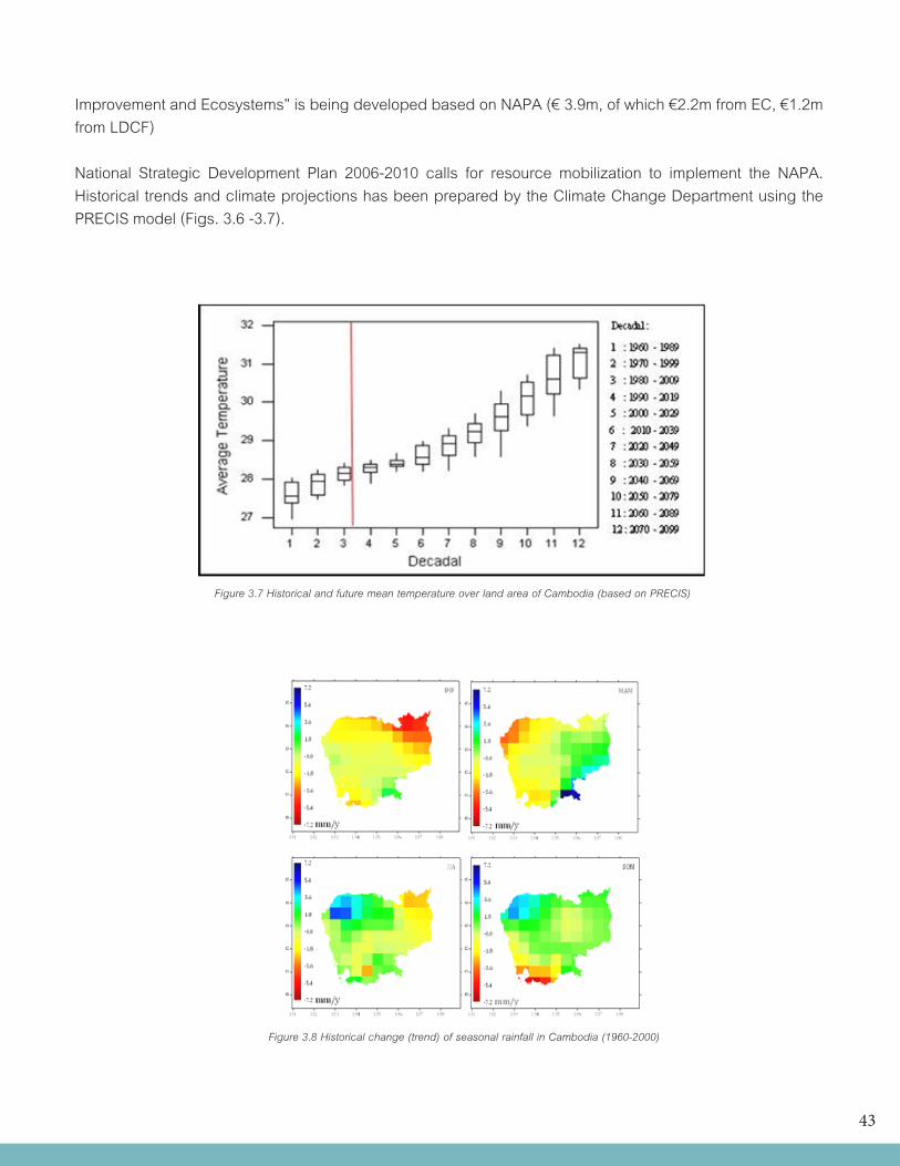
43
Improvement and Ecosystems” is being developed based on NAPA (€ 3.9m, of which €2.2m from EC, €1.2m from LDCF)
National Strategic Development Plan 2006-2010 calls for resource mobilization to implement the NAPA. Historical trends and climate projections has been prepared by the Climate Change Department using the PRECIS model (Figs. 3.6 -3.7).
Figure 3.7 Historical and future mean temperature over land area of Cambodia (based on PRECIS)
Figure 3.8 Historical change (trend) of seasonal rainfall in Cambodia (1960-2000)
44
Based on data 1960-2000, Cambodian climate (rainfall and temperature) has already changed, and the future rainfall pattern will continue to change depending on emission scenarios
Needs: •Vulnerabilityandriskassessment •Improvementondatamanagementsystem •Climatemodelers •Coordinationamongagenciesrelatedtoclimatechangeactivities •RegionalcooperationforCCproject •Understandingoftheimpactsofclimatechangeondifferenteconomicsectors •Downscalingcapacitytosupportlocaladaptationtoclimatechange
3.16 Media
The Cambodian Media sector is vibrant and largely unregulated. This situation has led to the establishment of numerous radio, television and print media outlets. Many private sector companies have moved into the media sector, which represents a significant change from many years of state-run broadcasting and publishing.
Since emerging from the communist governments of the Khmer Rouge and the Viet Nam-backed People's Republic of Kampuchea regime, the Cambodian media sector has become one of Southeast Asia's liveliest and most free, although a lack of professional journalism training and ethics, and intimidation by both government and private interests limit the Cambodian media's influence.
There are 11 TV stations nationwide, including two relay stations with French, Thai and Vietnamese broad-casts, as well as 12 regional low-power stations (as of 2006). On radio, Cambodia has two AM stations and at least 52 FM stations. There are over 100 registered newspapers in Cambodia, of which only a handful publish regularly. Perhaps less than 20 of these could be regarded as ‘real’ newspapers, with paid staff and a predictable publishing schedule. The leading Khmer daily newspaper is Rasmei Kampuchea (Light of Kampuchea) Daily, established in 1993, which has a section on arts and culture. Kampuchea Thmei Daily, another broadsheet, has emerged recently as its strongest competitor.
Responsibility for regulation of the media sector in Cambodia is shared between the Ministry of Information and the Ministry of Posts and Telecommunications, with the Minister of the Interior as the ultimate upholder and enforcer of the law. While the duties of these ministries in relation to the media are set out in their respective Decrees and Sub Decrees, there is at present no comprehensive legislation relating to broadcast, print and digital media in Cambodia.
45
4 THE METEOROLOGICAL AND HYDROLOGICAL SERVICE OF CAMBODIA IN A NUTSHELL
4.1 Brief History
Meteorological observation in Cambodia was established for measurement of climate in 1894. However, meteorological service was not properly established until after independence in 1954. Although there had been some minimal activities before Cambodia had became a member of the World Meteorological Organization (WMO) on November 08, 1955.
In 1964 the meteorological network consisted of 10 synoptic and climatological stations and more than 100 rain gauges across the country. There was the National Forecasting Center at Pochentong International Airport, located at southwest of Phnom Penh. In 1971, WMO had introduced some programs for further strengthening the Cambodia National Meteorological Services (CNMS). The project, funded by the United Nations Development Programme (UNDP) and planned for 1972-1977 was discontinued in 1975 due to political upheavals in Cambodia. Between 1975 and 1979 the CNMS was abandoned, resulting in a complete disruption of entire meteorological network. After 1979, with the assistance of Russia, some services for the aviation purposes have been restored. Since 1982 some out-of-date Russia instruments and about 33 rain gauges were brought in and installed at selected five synoptic stations. However in 1992, all the supports from Russia assistance ended and the Meteorological services had many difficulties.
The Department of Agriculture Hydraulic and Hydro-Meteorology (DAHHM) has become the General Directorate of Irrigation, Meteorology and Hydrology (GDIMH) on September 30, 1996. The GDIMH then became the Ministry of Water Resources and Meteorology (MOWRAM) on November 30, 1998. At the present, all meteorological activities in Cambodia are conducted by the Department of Meteorology (DOM), under the umbrella of MOWRAM.
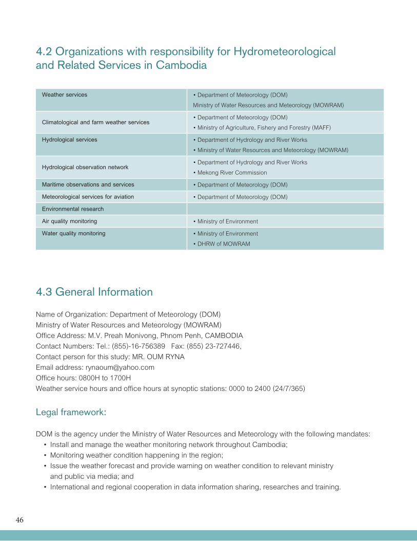
46
4.2 Organizations with responsibility for Hydrometeorologicaland Related Services in Cambodia
Weather services •Department of Meteorology (DOM)Ministry of Water Resources and Meteorology (MOWRAM)
Climatological and farm weather services•Department of Meteorology (DOM)•Ministry of Agriculture, Fishery and Forestry (MAFF)
Hydrological services •Department of Hydrology and River Works •Ministry of Water Resources and Meteorology (MOWRAM)
Hydrological observation network•Department of Hydrology and River Works •Mekong River Commission
Maritime observations and services •Department of Meteorology (DOM)
Meteorological services for aviation •Department of Meteorology (DOM)
Environmental research
Air quality monitoring •Ministry of Environment
Water quality monitoring •Ministry of Environment•DHRW of MOWRAM
4.3 General Information
Name of Organization: Department of Meteorology (DOM)Ministry of Water Resources and Meteorology (MOWRAM)Office Address: M.V. Preah Monivong, Phnom Penh, CAMBODIAContact Numbers: Tel.: (855)-16-756389 Fax: (855) 23-727446,Contact person for this study: MR. OUM RYNAEmail address: [email protected] hours: 0800H to 1700HWeather service hours and office hours at synoptic stations: 0000 to 2400 (24/7/365)
Legal framework:
DOM is the agency under the Ministry of Water Resources and Meteorology with the following mandates: • InstallandmanagetheweathermonitoringnetworkthroughoutCambodia; •Monitoringweatherconditionhappeningintheregion; • Issuetheweatherforecastandprovidewarningonweatherconditiontorelevantministry and public via media; and • Internationalandregionalcooperationindatainformationsharing,researchesandtraining.
47
The Department of Hydrology and River Works (DHRW) which is also under the umbrella of MOWRAM is in charge of all hydrological activities in Cambodia. DHRW consists of 5 offices: Administration Office, Research and Flood Fore-casting Office, Water Quality Analysis Office, Hydrological Works Office, and River BankProtection Office. DHRW has the followingfunctions:
• Strategic of installing hydrology stations on the main water courses in order to serve water resources sector development and management; •Short,mediumandlongtermstrategicplanon river bank protectionerosion control, sediment and morphology monitoring ; • To establish hydrological and groundwater observation/ monitoring stations to collect data to assess national water resource potential for use in national economic development and environmental management ; • To implement water level, discharge and sediment transport at each major rivers in the national 39 river basins including the Mekong-Tonle Sap-Bassac river systems and transboundary rivers; • Tocollect,analyseandmonitorwaterqualityat key hydrological stations and sub-river basins including transboundary rivers ; • Todevelopcapacity inanalyticalhydrologyat sub-basin level supporting integrated resource evaluation, development and management ;
• To provide short, medium and long term forecast for water availability at each sub- catchment for planning and management ; and •Todisseminatehydrologicalinformationthrough regular publication of primary data, near real time data, flood/drought hazards maps using geographical information system .
4.4 Evaluation criterion Concerning the duties and responsibilities of DOM, it has special relationships and responsibilities with several ministries and state bodies. - Ministry of Environment - Ministry of Agriculture Forestry and Fishery, - National Committee for Management (NCDM) - Ministry of Public Works and Transport - Ministry of Labor and Social Welfare - Ministry of Industry, Mines and Energy - Cambodian Red Cross - Cambodia National Mekong Committee - Ministry of Land Management Urban and Construction
4.5 Annual report
DOM does not publish an annual report.
4.6 Organizational structure
The organizational structure of DOM is illustrated in Figure 4.1. It is headed by a Director who reports directly to the Minister. In line with its responsibilities, DOM organizational structure is divided into 6 main offices namely: Administrative Office, Observation Office, Equipment Office, Forecasts and Researches Office, Climate Office and Hydrometeorological Office. The Hydrometeorological Office is in charge of the 21 provincial stations all over Cambodia.
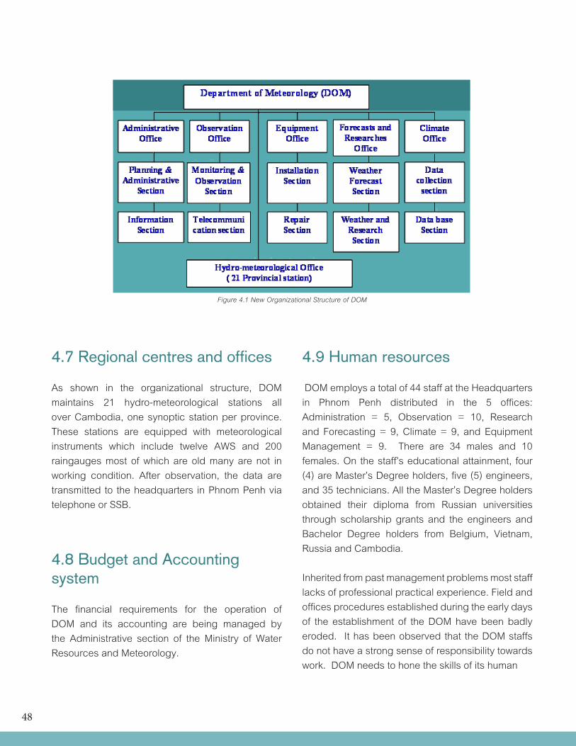
48
4.7 Regional centres and offices
As shown in the organizational structure, DOM maintains 21 hydro-meteorological stations all over Cambodia, one synoptic station per province. These stations are equipped with meteorological instruments which include twelve AWS and 200 raingauges most of which are old many are not in working condition. After observation, the data are transmitted to the headquarters in Phnom Penh via telephone or SSB.
4.8 Budget and Accounting system
The financial requirements for the operation of DOM and its accounting are being managed by the Administrative section of the Ministry of Water Resources and Meteorology.
4.9 Human resources
DOM employs a total of 44 staff at the Headquarters in Phnom Penh distributed in the 5 offices: Administration = 5, Observation = 10, Research and Forecasting = 9, Climate = 9, and Equipment Management = 9. There are 34 males and 10 females. On the staff’s educational attainment, four (4) are Master’s Degree holders, five (5) engineers, and 35 technicians. All the Master’s Degree holders obtained their diploma from Russian universities through scholarship grants and the engineers and Bachelor Degree holders from Belgium, Vietnam, Russia and Cambodia.
Inherited from past management problems most staff lacks of professional practical experience. Field and offices procedures established during the early days of the establishment of the DOM have been badly eroded. It has been observed that the DOM staffs do not have a strong sense of responsibility towards work. DOM needs to hone the skills of its human
Figure 4.1 New Organizational Structure of DOM
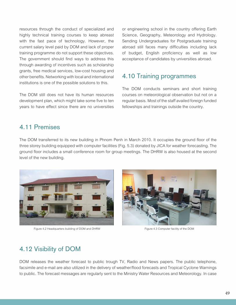
49
resources through the conduct of specialized and highly technical training courses to keep abreast with the fast pace of technology. However, the current salary level paid by DOM and lack of proper training programme do not support these objectives. The government should find ways to address this through awarding of incentives such as scholarship grants, free medical services, low-cost housing and other benefits. Networking with local and international institutions is one of the possible solutions to this.
The DOM still does not have its human resources development plan, which might take some five to ten years to have effect since there are no universities
4.11 Premises
The DOM transferred to its new building in Phnom Penh in March 2010. It occupies the ground floor of the three storey building equipped with computer facilities (Fig. 5.3) donated by JICA for weather forecasting. The ground floor includes a small conference room for group meetings. The DHRW is also housed at the second level of the new building.
or engineering school in the country offering Earth Science, Geography, Meteorology and Hydrology. Sending Undergraduates for Postgraduate training abroad still faces many difficulties including lack of budget, English proficiency as well as low acceptance of candidates by universities abroad.
4.10 Training programmes
The DOM conducts seminars and short training courses on meteorological observation but not on a regular basis. Most of the staff availed foreign funded fellowships and trainings outside the country.
Figure 4.2 Headquarters building of DOM and DHRW Figure 4.3 Computer facility of the DOM
4.12 Visibility of DOM
DOM releases the weather forecast to public trough TV, Radio and News papers. The public telephone, facsimile and e-mail are also utilized in the delivery of weather/flood forecasts and Tropical Cyclone Warnings to public. The forecast messages are regularly sent to the Ministry Water Resources and Meteorology. In case
50
of extreme natural disaster, urgent warnings and advisories are reported to and announced by the Prime Minister on TV. National and Municipal Radio Stations are frequently broadcasting in many programs every day. DOM needs to enhance its relationship to the media
4.13 International memberships and networking Cambodia, through DOM is a member of the World Meteorological Organization with the Minister of the MOWRAM as the Permanent Representative. Cambodia is also a member of the Typhoon Committee and the Mekong River Commission, International Association of Hydrologists (IAH) and IAHS of UNESCO.
4.14 Cooperation with other users of hydro-meteorological servicesin Cambodia
There is a need for DOM to enhance its linkages with other government agencies like, the Ministry of Public Works and Transport, Ministry of Environment, Ministry of Industry, Mines and Energy, Ministry of Agriculture, Forestry and Fishery (MAFF), National Committee for Disaster Management, Cambodia Red Cross, etc. Protocols on sharing and transfer of hydrometeorological data and information should be established. Collaborative projects (seminars/workshops) and IEC campaigns among the ministries/agencies should be undertaken to improve hydrometeorological services.
51
5 CURRENT SERVICES OF DOM
5.1 Weather services
The increasing frequency and intensity of extreme weather events such as floods and drought have caught the attention of the general public on the importance of weather services being provided by NMHSs. Advance forecasts of El Niño/La Niña, warnings for approaching tropical cyclone and heavy rains enable all sectors and the communities to plan their activities and the people to prepare to reduce or avoid damages from these natural hazards. Of all the sectors, the agriculture and transportation industries particularly shipping and aviation are the major beneficiaries of these weather services.
The DOM is the technical department directly under the Ministry of Water Resources and Meteorology mandated to issue weather forecasts and provide warning on weather condition to relevant ministries and public. It provides short, medium and long range weather forecasts and issues Tropical Cyclone Warnings to inform the public of impending hazards.
When there is a tropical cyclone activity in the vicinity of Indochina Peninsula, DOM conducts non-stop monitoring 24 hours a day. Typhoon forecasting is made through subjective analysis of weather maps and weather reports of surrounding countries including weather forecasts for marine issued by the Royal Observatory of Hong Kong. DOM continuously monitors its meteorological observation network, satellite images, and weather charts for tracking of the cyclone.
5.1.1 Forecasts and Tropical Cyclone Warnings Dissemination
Tropical Cyclone forecast Methodology: The forecast methodologies used are: • Theprocedureisbasedonthemethoddelivered by Dvorak technique. • Analysissurfaceobservationbyusingcompass method to determine pressure center of Tropical Cyclone. • TheuseofJapan’sMTSATimageriesoftropical cyclones, has improved the operational work of DOM in analysing and determination of the cyclone’s eye and rainfall.
• Pressure falling method: the use of pressure changes can be especially helpful in short range forecasting.
DOM also utilizes NWP products from the following foreign forecasting centers: • Typhoon forecast from RSMC (JMA) and products from Hong Kong Observatory • FNMOCWXMAP, oneweek forecastwith time interval every 6 hours • ADPC–RIMES: DOM receives through e-mail daily advisory from the Regional Integrated Multi – Hazards EarlyWarning System for the Asia Pacific Region which has been developed under the agreement between WMO and ADPC
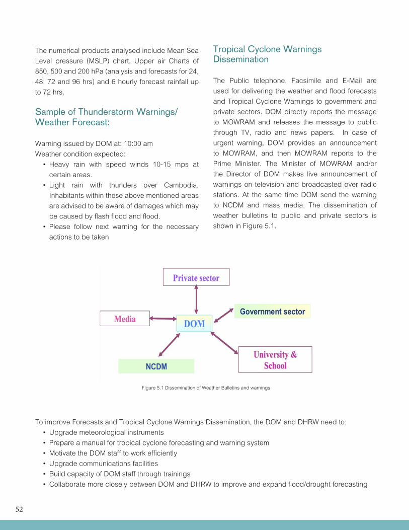
52
The numerical products analysed include Mean Sea Level pressure (MSLP) chart, Upper air Charts of 850, 500 and 200 hPa (analysis and forecasts for 24, 48, 72 and 96 hrs) and 6 hourly forecast rainfall up to 72 hrs.
Sample of Thunderstorm Warnings/Weather Forecast:
Warning issued by DOM at: 10:00 amWeather condition expected: • Heavy rain with speed winds 10-15 mps at certain areas. • Light rain with thunders over Cambodia. Inhabitants within these above mentioned areas are advised to be aware of damages which may be caused by flash flood and flood. • Please follow next warning for the necessary actions to be taken
Tropical Cyclone Warnings Dissemination
The Public telephone, Facsimile and E-Mail are used for delivering the weather and flood forecasts and Tropical Cyclone Warnings to government and private sectors. DOM directly reports the message to MOWRAM and releases the message to public through TV, radio and news papers. In case of urgent warning, DOM provides an announcement to MOWRAM, and then MOWRAM reports to the Prime Minister. The Minister of MOWRAM and/or the Director of DOM makes live announcement of warnings on television and broadcasted over radio stations. At the same time DOM send the warning to NCDM and mass media. The dissemination of weather bulletins to public and private sectors is shown in Figure 5.1.
To improve Forecasts and Tropical Cyclone Warnings Dissemination, the DOM and DHRW need to: • Upgrademeteorologicalinstruments • Prepareamanualfortropicalcycloneforecastingandwarningsystem •MotivatetheDOMstafftoworkefficiently • Upgradecommunicationsfacilities • BuildcapacityofDOMstaffthroughtrainings • CollaboratemorecloselybetweenDOMandDHRWtoimproveandexpandflood/droughtforecasting
Figure 5.1 Dissemination of Weather Bulletins and warnings
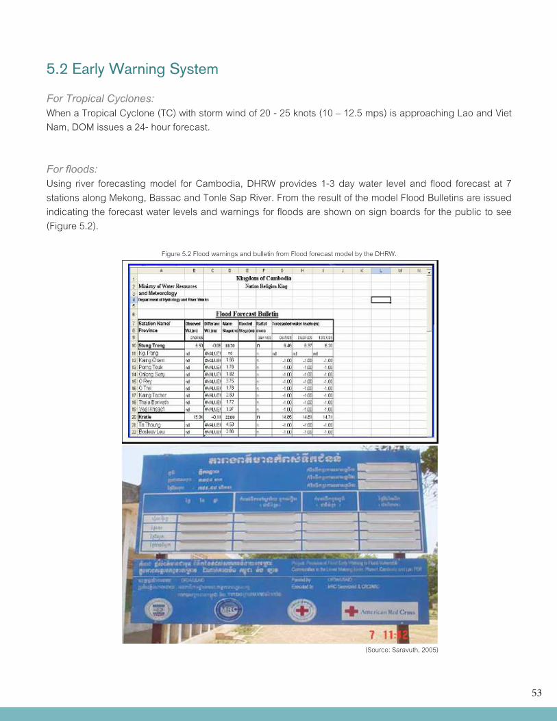
53
5.2 Early Warning System
For Tropical Cyclones: WhenaTropicalCyclone(TC)withstormwindof20-25knots(10–12.5mps)isapproachingLaoandVietNam, DOM issues a 24- hour forecast.
For floods:Using river forecasting model for Cambodia, DHRW provides 1-3 day water level and flood forecast at 7 stations along Mekong, Bassac and Tonle Sap River. From the result of the model Flood Bulletins are issued indicating the forecast water levels and warnings for floods are shown on sign boards for the public to see (Figure 5.2).
Figure 5.2 Flood warnings and bulletin from Flood forecast model by the DHRW.
(Source: Saravuth, 2005)
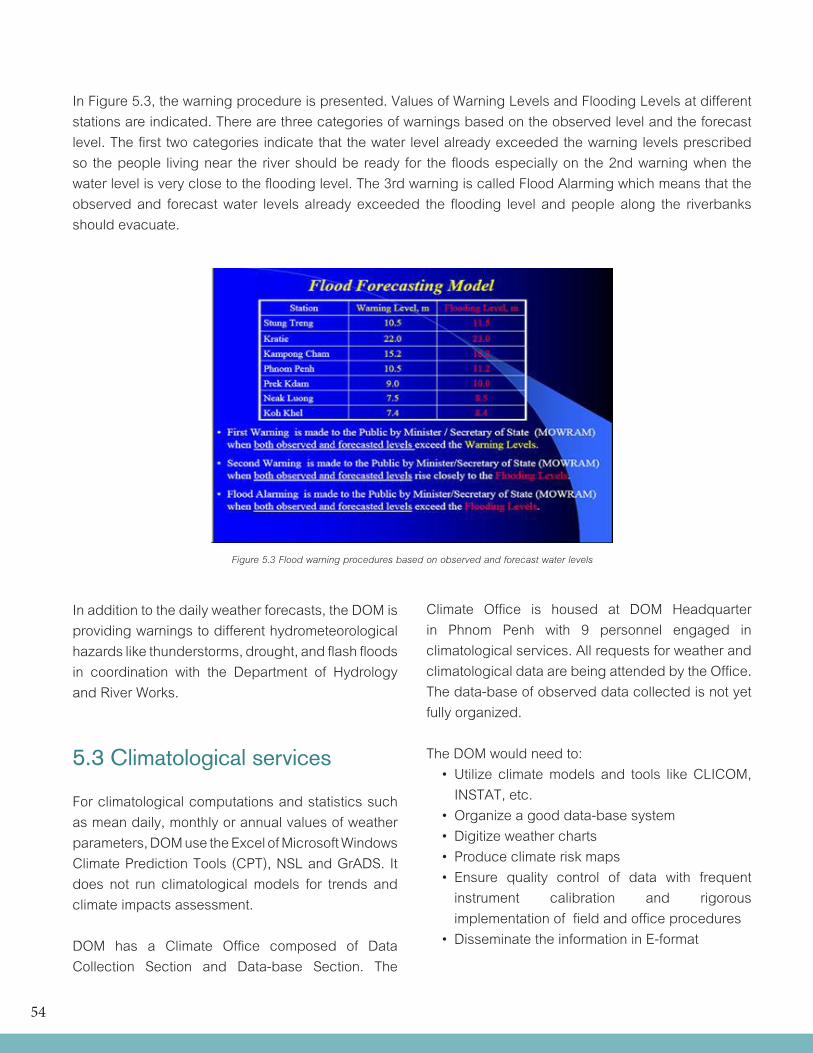
54
In Figure 5.3, the warning procedure is presented. Values of Warning Levels and Flooding Levels at different stations are indicated. There are three categories of warnings based on the observed level and the forecast level. The first two categories indicate that the water level already exceeded the warning levels prescribed so the people living near the river should be ready for the floods especially on the 2nd warning when the water level is very close to the flooding level. The 3rd warning is called Flood Alarming which means that the observed and forecast water levels already exceeded the flooding level and people along the riverbanks should evacuate.
In addition to the daily weather forecasts, the DOM is providing warnings to different hydrometeorological hazards like thunderstorms, drought, and flash floods in coordination with the Department of Hydrology and River Works.
5.3 Climatological services
For climatological computations and statistics such as mean daily, monthly or annual values of weather parameters, DOM use the Excel of Microsoft Windows Climate Prediction Tools (CPT), NSL and GrADS. It does not run climatological models for trends and climate impacts assessment.
DOM has a Climate Office composed of Data Collection Section and Data-base Section. The
Figure 5.3 Flood warning procedures based on observed and forecast water levels
Climate Office is housed at DOM Headquarter in Phnom Penh with 9 personnel engaged in climatological services. All requests for weather and climatological data are being attended by the Office. The data-base of observed data collected is not yet fully organized.
The DOM would need to: • Utilize climatemodels and tools likeCLICOM, INSTAT, etc. • Organizeagooddata-basesystem • Digitizeweathercharts • Produceclimateriskmaps • Ensure quality control of data with frequent instrument calibration and rigorous implementation of field and office procedures • DisseminatetheinformationinE-format
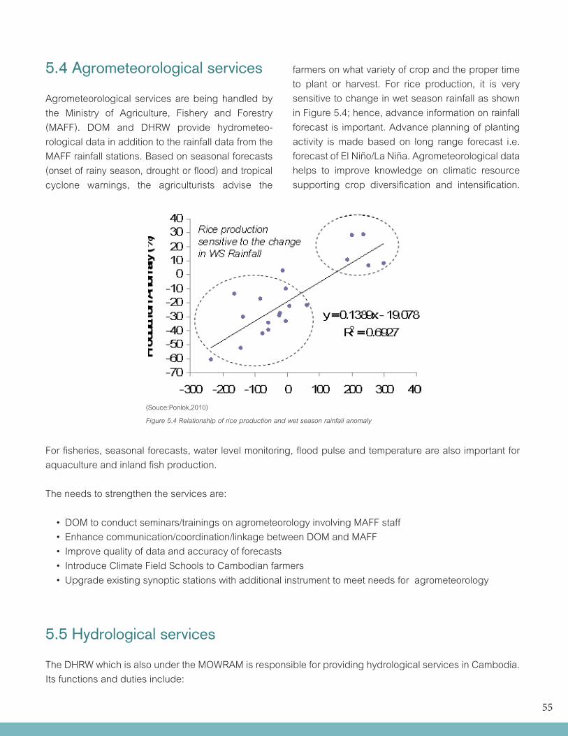
55
5.4 Agrometeorological services
Agrometeorological services are being handled by the Ministry of Agriculture, Fishery and Forestry (MAFF). DOM and DHRW provide hydrometeo-rological data in addition to the rainfall data from the MAFF rainfall stations. Based on seasonal forecasts (onset of rainy season, drought or flood) and tropical cyclone warnings, the agriculturists advise the
farmers on what variety of crop and the proper time to plant or harvest. For rice production, it is very sensitive to change in wet season rainfall as shown in Figure 5.4; hence, advance information on rainfall forecast is important. Advance planning of planting activity is made based on long range forecast i.e. forecast of El Niño/La Niña. Agrometeorological data helps to improve knowledge on climatic resource supporting crop diversification and intensification.
Figure 5.4 Relationship of rice production and wet season rainfall anomaly
(Souce:Ponlok,2010)
For fisheries, seasonal forecasts, water level monitoring, flood pulse and temperature are also important for aquaculture and inland fish production.
The needs to strengthen the services are:
• DOMtoconductseminars/trainingsonagrometeorologyinvolvingMAFFstaff • Enhancecommunication/coordination/linkagebetweenDOMandMAFF • Improvequalityofdataandaccuracyofforecasts • IntroduceClimateFieldSchoolstoCambodianfarmers • Upgradeexistingsynopticstationswithadditionalinstrumenttomeetneedsforagrometeorology
5.5 Hydrological services
The DHRW which is also under the MOWRAM is responsible for providing hydrological services in Cambodia. Its functions and duties include:
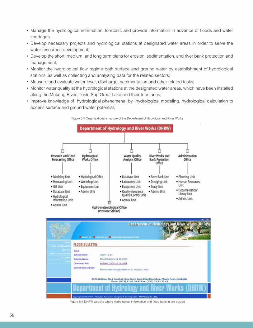
56
• Managethehydrologicalinformation,forecast,andprovideinformationinadvanceoffloodsandwater shortages. • Developnecessaryprojectsandhydrologicalstationsatdesignatedwaterareas inorder toserve the water resources development; • Developtheshort,medium,andlongtermplansforerosion,sedimentation,andriverbankprotectionand management; • Monitor thehydrological flow regimebothsurfaceandgroundwaterbyestablishmentofhydrological stations, as well as collecting and analyzing data for the related sectors; • Measureandevaluatewaterlevel,discharge,sedimentationandotherrelatedtasks; •Monitorwaterqualityatthehydrologicalstationsatthedesignatedwaterareas,whichhavebeeninstalled along the Mekong River, Tonle Sap Great Lake and their tributaries; • Improveknowledgeofhydrologicalphenomena,byhydrologicalmodeling,hydrologicalcalculationto access surface and ground water potential;
Figure 5.5 Organizational structure of the Department of Hydrology and River Works
Figure 5.6 DHRW website where hydrological information and flood bulletin are posted
57
The DHRW maintains a website where it posts hydrological data and information i.e. water level forecasts, flood bulletin etc. for public to see.
5.6 Marine services
DOM does not provide marine services but hydrological information for waterways along the Mekong River are provided by the BHRW. With hydrological network expansion to the coastal areas, tidal stations will be established at some important ports.
5.7 Environmental services
5.7.1 Water quality
As one of its functions, DHRW monitors water quality at key hydrological stations, along the Mekong River, Tonle Sap Great Lake and their tributaries. A number of line ministries are involved in defining and implementing drinking water quality standard namely: Ministry of Health (MOH), Ministry of Industry Mine and Energy (MIME) and the Ministry of Rural Development (MRD). The MOH defines the water quality for human health, the MIME for industrial water supply and sanitation and the MRD for rural water supply and sanitation.
5.7.2 Air quality
As regards to air quality, the Department of Air Pollution Control of the MoE is responsible agency. DOM only provides information on atmospheric condition and meteorological parameters such as winds and temperature.
5.8 UV radiation: None
5.9 Climate Change relatedservices
The Climate Change Department of the MoE undertake studies and provides climate change related services in Cambodia. The Greenhouse Gas inventory was completed in year 2000. Climate change adaptation, mitigation and vulnerability assessment projects are being undertaken under the UNDP Climate Change Programme.
Historical trends and climate projections have been prepared by the Climate Change Department using the PRECIS model. Climatological data of rainfall and temperature from the DOM are used in the climate trends and projections.
5.10 R&D based Expert Services
The DOM staff at present are not involved in any research activities.
5.11 Information services
The DOM used to have a website ([email protected]) but due to some internal problems, it was terminated. Creation of new website is being planned. At this time, information services of the DOM are through radio, TV and newspaper. A brochure on the profile of DOM is available; however, it needs to be updated.
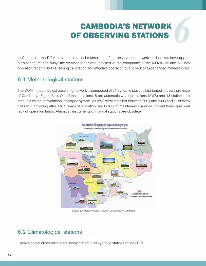
58
6 CAMBODIA’S NETWORK OF OBSERVING STATIONS
In Cambodia, the DOM only operates and maintains surface observation network. It does not have upper-air stations, marine buoy, the weather radar was installed at the compound of the MOWRAM and put into operation recently but still facing calibration and effective operation due to lack of experienced meteorologist.
6.1 Meteorological stations
The DOM meteorological observing network is composed of 21 Synoptic stations distributed in every province of Cambodia (Figure 6.1). Out of these stations, 8 are automatic weather stations (AWS) and 13 stations are manuals by the conventional analogue system. All AWS were installed between 2001 and 2003 and all of them ceased functioning after 1 to 2 years of operation due to lack of maintenance and insufficient training as well lack of operation funds. Almost all instruments of manual stations are obsolete.
6.2 Climatological stations
Climatological observations are incorporated in all synoptic stations of the DOM.
Figure 6.1 Meteorological network of stations in Cambodia
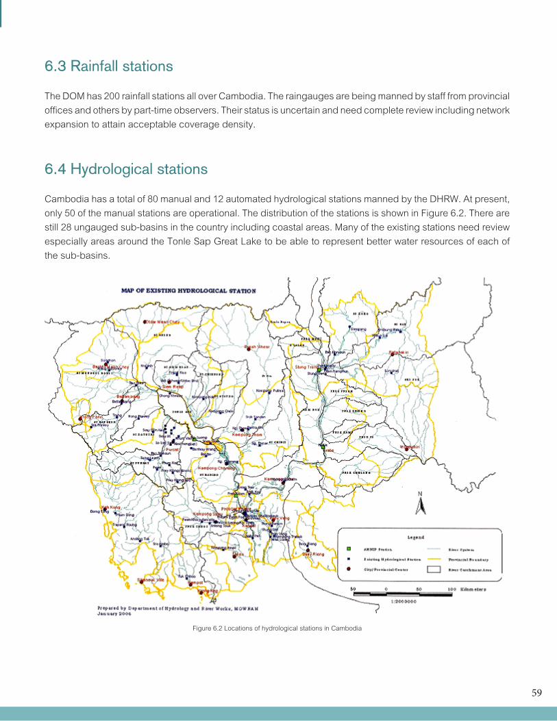
59
6.3 Rainfall stations
The DOM has 200 rainfall stations all over Cambodia. The raingauges are being manned by staff from provincial offices and others by part-time observers. Their status is uncertain and need complete review including network expansion to attain acceptable coverage density.
6.4 Hydrological stations
Cambodia has a total of 80 manual and 12 automated hydrological stations manned by the DHRW. At present, only 50 of the manual stations are operational. The distribution of the stations is shown in Figure 6.2. There are still 28 ungauged sub-basins in the country including coastal areas. Many of the existing stations need review especially areas around the Tonle Sap Great Lake to be able to represent better water resources of each of the sub-basins.
Figure 6.2 Locations of hydrological stations in Cambodia
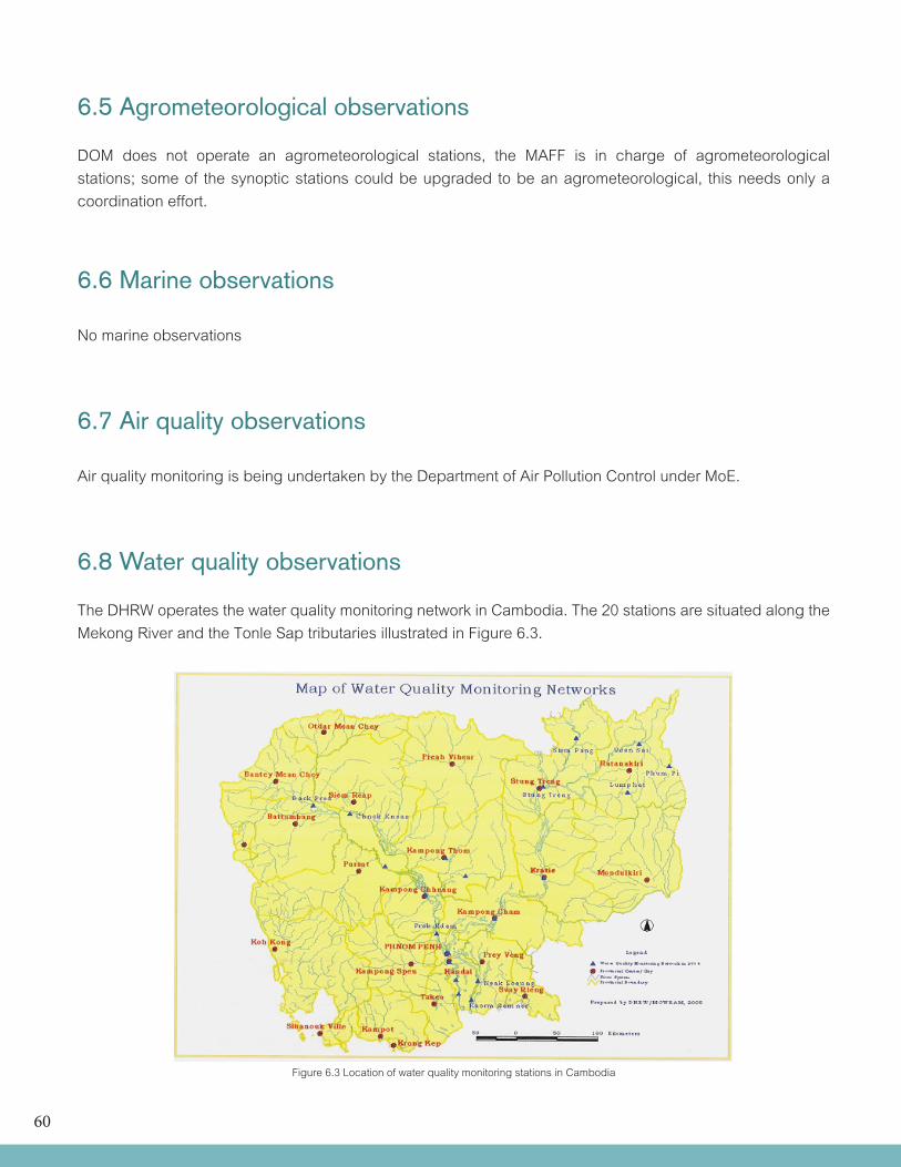
60
Figure 6.3 Location of water quality monitoring stations in Cambodia
6.5 Agrometeorological observations
DOM does not operate an agrometeorological stations, the MAFF is in charge of agrometeorological stations; some of the synoptic stations could be upgraded to be an agrometeorological, this needs only a coordination effort.
6.6 Marine observations
No marine observations
6.7 Air quality observations
Air quality monitoring is being undertaken by the Department of Air Pollution Control under MoE.
6.8 Water quality observations
The DHRW operates the water quality monitoring network in Cambodia. The 20 stations are situated along the Mekong River and the Tonle Sap tributaries illustrated in Figure 6.3.
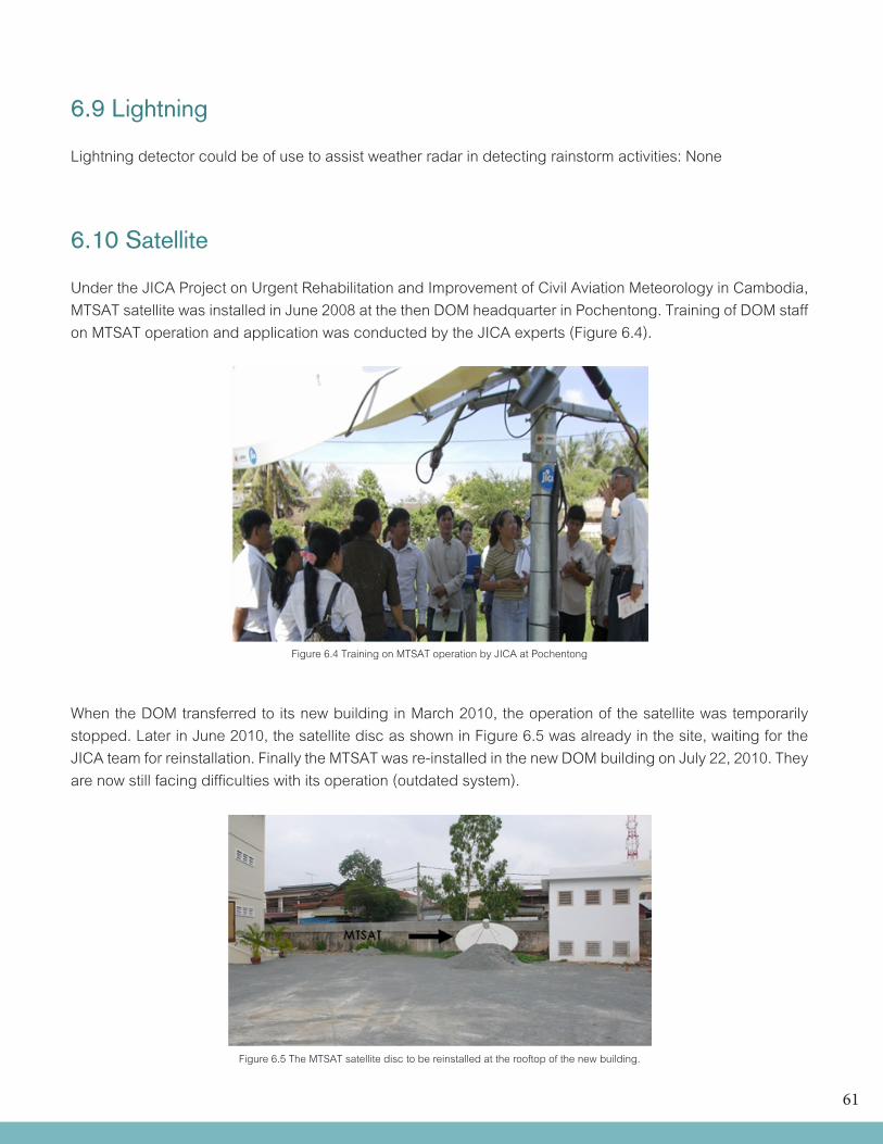
61
6.9 Lightning
Lightning detector could be of use to assist weather radar in detecting rainstorm activities: None
6.10 Satellite
Under the JICA Project on Urgent Rehabilitation and Improvement of Civil Aviation Meteorology in Cambodia, MTSAT satellite was installed in June 2008 at the then DOM headquarter in Pochentong. Training of DOM staff on MTSAT operation and application was conducted by the JICA experts (Figure 6.4).
When the DOM transferred to its new building in March 2010, the operation of the satellite was temporarily stopped. Later in June 2010, the satellite disc as shown in Figure 6.5 was already in the site, waiting for the JICA team for reinstallation. Finally the MTSAT was re-installed in the new DOM building on July 22, 2010. They are now still facing difficulties with its operation (outdated system).
Figure 6.4 Training on MTSAT operation by JICA at Pochentong
Figure 6.5 The MTSAT satellite disc to be reinstalled at the rooftop of the new building.
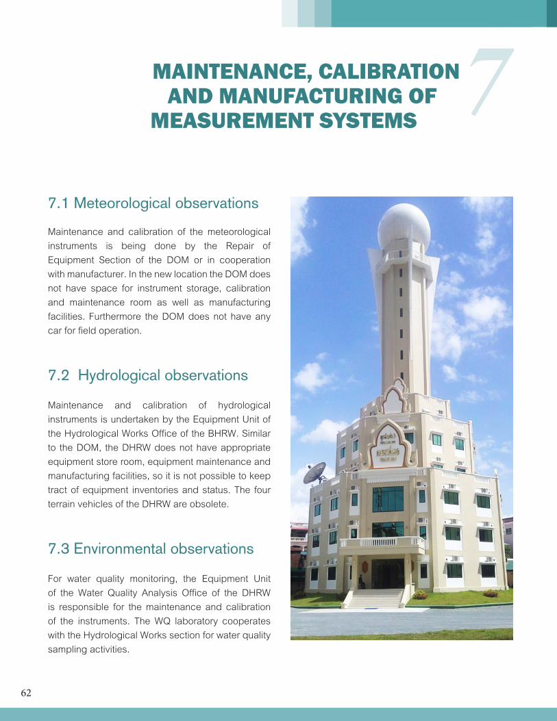
62
7 MAINTENANCE, CALIBRATION AND MANUFACTURING OF MEASUREMENT SYSTEMS
7.1 Meteorological observations
Maintenance and calibration of the meteorological instruments is being done by the Repair of Equipment Section of the DOM or in cooperation with manufacturer. In the new location the DOM does not have space for instrument storage, calibration and maintenance room as well as manufacturing facilities. Furthermore the DOM does not have any car for field operation.
7.2 Hydrological observations
Maintenance and calibration of hydrological instruments is undertaken by the Equipment Unit of the Hydrological Works Office of the BHRW. Similar to the DOM, the DHRW does not have appropriate equipment store room, equipment maintenance and manufacturing facilities, so it is not possible to keep tract of equipment inventories and status. The four terrain vehicles of the DHRW are obsolete.
7.3 Environmental observations
For water quality monitoring, the Equipment Unit of the Water Quality Analysis Office of the DHRW is responsible for the maintenance and calibration of the instruments. The WQ laboratory cooperates with the Hydrological Works section for water quality sampling activities.
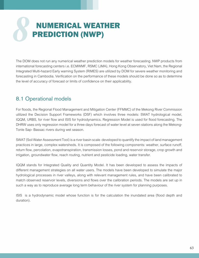
63
8 NUMERICAL WEATHER PREDICTION (NWP)
The DOM does not run any numerical weather prediction models for weather forecasting. NWP products from international forecasting centers i.e. ECMWMF, RSMC (JMA), Hong Kong Observatory, Viet Nam, the Regional Integrated Multi-hazard Early warning System (RIMES) are utilized by DOM for severe weather monitoring and forecasting in Cambodia. Verification on the performance of these models should be done so as to determine the level of accuracy of forecast or limits of confidence on their applicability.
8.1 Operational models
For floods, the Regional Flood Management and Mitigation Center (FFMMC) of the Mekong River Commission utilized the Decision Support Frameworks (DSF) which involves three models: SWAT hydrological model, IQQM, URBS, for river flow and ISIS for hydrodynamics. Regression Model is used for flood forecasting. The DHRW uses only regression model for a three days forecast of water level at seven stations along the Mekong-Tonle Sap- Bassac rivers during wet season.
SWAT (Soil Water Assessment Tool) is a river basin scale developed to quantify the impact of land management practices in large, complex watersheds. It is composed of the following components: weather, surface runoff, return flow, percolation, evapotranspiration, transmission losses, pond and reservoir storage, crop growth and irrigation, groundwater flow, reach routing, nutrient and pesticide loading, water transfer.
IQQM stands for Integrated Quality and Quantity Model. It has been developed to assess the impacts of different management strategies on all water users. The models have been developed to simulate the major hydrological processes in river valleys, along with relevant management rules, and have been calibrated to match observed reservoir levels, diversions and flows over the calibration periods. The models are set up in such a way as to reproduce average long term behaviour of the river system for planning purposes.
ISIS is a hydrodynamic model whose function is for the calculation the inundated area (flood depth and duration).
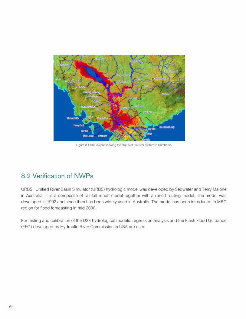
64
8.2 Verification of NWPs
URBS, Unified River Basin Simulator (URBS) hydrologic model was developed by Seqwater and Terry Malone in Australia. It is a composite of rainfall runoff model together with a runoff routing model. The model was developed in 1992 and since then has been widely used in Australia. The model has been introduced to MRC region for flood forecasting in mid 2000.
For testing and calibration of the DSF hydrological models, regression analysis and the Flash Flood Guidance (FFG) developed by Hydraulic River Commission in USA are used.
Figure 8.1 DSF output showing the status of the river system in Cambodia
65
9 INFORMATION, COMMUNICATION AND TECHNOLOGY
9.1 Communication facilities
The communication facilities of DMH are summarized in Table 9.1.
Table 9.1 Communication facilities for transmission, reception and exchange of data and products.RD = to receive data/observations, RI = to receive information/products, SD = to send data/ observation,
SI = to send information/products, RW = to receive warnings, SW = to send warnings.
RD RI SD SI RW SW Remarks
Telephone X X
Mobile Phone X X
Telefax X X X X X
Dedicated Leased Lines X X X X X
UHF radio transceiver
High frequency/Single side band radio X X X
HF Radio Email
Aeronautical Fixed Telecommunication Network
Very Small Aperture Terminal
Data Collection Platforms used to transmit data from AWSs
Global Telecommunication system (WMO-GTS) X X X X
MTSAT Satellite system X
Other satellite systems
Internet X X X X
Email X X X X
Post/mail
Print media
TV–national X X
TV-commercial
Radio X X
Bulletins
66
At national level: Data transmission from the provincial stations is manually operated using HF single side band radio, public telephone, and Fax (Figure 9.1) then the data are compiled into the prepared format for transmission to the GTS link.
International level: DOM in Phnom Penh has been reconnected to Bangkok through GTS since June 14, 2010. It now receives and transmits meteorological data for international use.
Figure 9.1Communication facility for domestic stations
Figure 9.2 Regional telecommunication network for Region II (Asia)
67
9.2 Data management
The observed data at the synoptic stations are reported to the Phnom Penh headquarter through SSB radio or telephone twice daily to be used in the weather forecast preparation. The data at the synoptic stations are also sent to Department of Meteorology headquarters in paper form several months after observation time for collection and future reference. These data are digitized or encoded into a data base.
Data Handling • Data transmission and data collection from different sources • Decoding of observations and plotting on weather maps • Analysis,briefingandforecasts
Quality monitoring of collected dataDOM does not conduct real-time quality control monitoring on logical checking for manned stations. A non real-time quality control system or checking is done during the encoding of collecteddata.
9.3 IT infrastructure
The DOM network has two internet connections, one for public IP for GTS Broadband (ADSL), with speed of 128/256 kbps.
9.4 IT Personnel
There are five IT personnel recruited and have been trained in France but how MOWRAM will retain them remains a problem.
9.5 Needs to improve communication systemand data management
DOM needs the following to improve its commu-nication system and data management:
• automationforreal-timedata • increasedatadensity • develop the data base system and data management • upgradediskstorageandbackupsystem • upgradethedevicesandsystem • enteringhistoricaldataintoelectronicdatabase • upgradeofsafetysystems • developmentofdataQCsystems • upgradetheexistingdatamanagementsystem • promotecommonreal-timeandotheruseofall hydro-meteorological and environmental data, user friendly system • upgrade the IT infrastructure, both hardware and software
68
10 NATIONAL AND INTERNATIONAL COOPERATION AND DATA SHARING
10.1 National
Meteorological and climatological data and information are provided to the public in hardcopy upon request. Most common users are those from agriculture, energy, education, transportation and environmental sectors.
On the national level, there is a need for DOM to strengthen its interaction or linkages with both public and private agencies. It is high time for them to go out of their shell and explore the opportunity to collaborate with other agencies that needs meteorological information and services like those mentioned above. They should collaborate with NDCM and the Media in Information Education and Communication campaign for public awareness on natural disasters; with MAFF on agrometeorological crop weather modelling and other activities for farmers and fishermen, with power sectors for wind energy utilization and many others.
It has been observed that DOM works independently at present, even coordination with DHRW is very poor. It only looks up to MOWRAM for support and guidance.
10.2 International
Cambodia is reconnected with WMO-GTS: to RTH Bangkok; FTP, TCP/IP protocol since June 14, 2010. They are now receiving meteorological data from other countries and sending SYNOP reports to WMO through GTS.
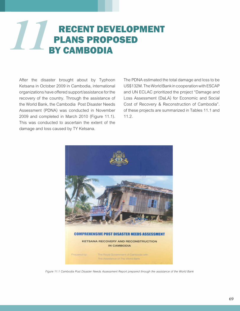
69
11
Figure 11.1 Cambodia Post Disaster Needs Assessment Report prepared through the assistance of the World Bank
RECENT DEVELOPMENT PLANS PROPOSED BY CAMBODIA
After the disaster brought about by Typhoon Ketsana in October 2009 in Cambodia, international organizations have offered support/assistance for the recovery of the country. Through the assistance of the World Bank, the Cambodia Post Disaster Needs Assessment (PDNA) was conducted in November 2009 and completed in March 2010 (Figure 11.1). This was conducted to ascertain the extent of the damage and loss caused by TY Ketsana.
The PDNA estimated the total damage and loss to be US$132M. The World Bank in cooperation with ESCAP and UN ECLAC prioritized the project “Damage and Loss Assessment (DaLA) for Economic and Social Cost of Recovery & Reconstruction of Cambodia”. of these projects are summarized in Tables 11.1 and 11.2.
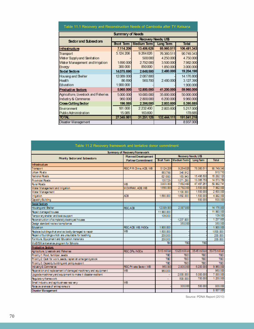
70
Source: PDNA Report (2010)
Table 11.1 Recovery and Reconstruction Needs of Cambodia after TY Ketsana
Table 11.2 Recovery framework and tentative donor commitment
71
The major concern of DOM is to strengthen its services through the following: • Improvement of forecasting capacity through advance studies and trainings • Improvement of severe weather monitoring capability, especially for typhoon when it approaches Indochina Peninsula • Improvementofprecisionofrainfallmonitoring • Establishment of real-time data transmission system • InstallationofAutomaticWeatherStation, • Request to WMO establish Sub - Regional Forecast Support Center to provide Severe Weather guidance to Southeast Asia • Strengtheningofwithregionalandinternational organization in term of disaster prevention and mitigation. • Medium to long term human resource development plan
The assistance being provided through these projects is generally for recovery of the different sectors of the society. For disaster management, US$8.937M is necessary; however nothing is specifically mentioned about the rehabilitation of the Department of Meteorology. It is important to strengthen the capacity of the DOM as a warning agency for preparedness to reduce damages from these natural disasters. Prevention is better than cure hence it is better to invest on forewarning or preventive measures to reduce if not avoid the damages.
From 2002 to 2007, US Office of Foreign Disaster Assistance (OFDA) provided funding to the American Red Cross to develop a community-based disaster preparedness capacity within the Cambodian Red Cross. The program included support for the establishment of a preparedness unit called Community Based Flood Early Warning System (CBFEWS) where community volunteers are trained to read and transmit rainfall data to the Red Cross Central Office then to DHRW to be used for flood forecasting. Villagers were provided with cell phones, flood markers and flood information boards, as well as training as observers to take wet-season water level measurements at 14 Villages in Leuk Dek and Peam Ro Districts, in Prey Veng Province, bordering Viet Nam. The processed data in the form of flood forecast or bulletin are sent back to the community for warning. The project also involved vulnerability assessment as well as the implementation of flood preparedness measures in flood-prone communities. In 2009, GTZ reactivated the CBFEWS in two districts operating only during flood season.
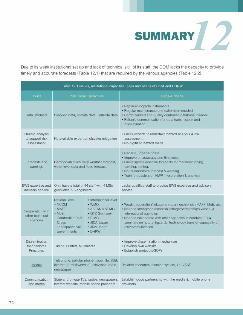
72
12 SUMMARY
Due to its weak institutional set up and lack of technical skill of its staff, the DOM lacks the capacity to provide timely and accurate forecasts (Table 12.1) that are required by the various agencies (Table 12.2).
Table 12.1 Issues, institutional capacities, gaps and needs of DOM and DHRW
Issues Institutional Capacities Gaps & Needs
Data products Synoptic data, climate data, satellite data,
•Replace/upgradeinstruments•Regularmaintenanceandcalibrationneeded•Computerizedandqualitycontrolleddatabaseneeded•Reliablecommunicationfordatatransmissionand dissemination
Hazard analysis to support risk assessment
No available expert on disaster mitigation•Lacksexpertstoundertakehazardanalysis&risk assessment•Nodigitizedhazardmaps
Forecasts and warnings
Cambodian cities daily weather forecast, water level data and flood forecast
•Radar&upper-airdata•Improveonaccuracyandtimeliness•Lacksspecial/specificforecastsformarine/shipping, farming, mining,•Nothunderstormforecast&warning•TrainforecastersonNWPinterpretation&analysis
EWS expertise and advisory service
Only have a total of 44 staff with 4 MSc graduates & 5 engineers
Lacks qualified staff to provide EWS expertise and advisory service
Cooperation with other technical
agencies
National level : •NCDM•MAFF•MoE•CambodianRed Cross•Local/provincial governments
•Internationallevel:•WMO•ASEAN’sSCMG•GTZGermany•RIMES•JICAJapan•JMAJapan•DHRW
•Weakcooperation/linkageandpartnershipwithMAFF,MoE,etc.•Needtostrengthen/establishlinkage/partnershipsw/local& international agencies•NeedtocollaboratewithotheragenciesinconductIEC& seminars on natural hazards, technology transfer especially on telecommunication
Dissemination mechanisms
PrinciplesOnline, Printed, Multimedia
•Improvedisseminationmechanism•Developownwebsite•Establishprotocols/SOPs
MeansTelephone, cellular phone, facsimile, SSB, internet (e-mail/website), television, radio, newspaper
Reliable telecommunication system, i.e. VSAT
Communicationand media
State and private TVs, radios, newspapers, internet website, mobile phone providers
Establish good partnership with the media & mobile phone providers
73
Table 12.2 Meteorological and hydrological data, products and services required by secto
SECTOR NEEDS
Agriculture
•Seasonalweatheroutlook•Moresitespecificlongtimehistoricalhydro-meteorologicaldataforplanning•Betterandmoresitespecificshorttermandmediumterm(1-5days),andlongtermweatherforecasts•Dataandforecastsonevapotranspiration,temperature•Dataonhumidity,windspeed&direction,rainfall•Monthly,yearly,normalvaluesofmet-hydroparameters•Cropspecificforecasts•FastcommunicationlinkofDAFFwithDOMfordatatransport•StrongcoordinationwithDAFF&otheragencies•Accessofmet-hydrodatafromregionalcenters•Historicaldataforlandresourcesplanning
Fisheries
•1-5dayweatherforecasts•Windspeedanddirection•Windforecastsincludinglocalwind,•Thunderstormswithgusts•visibility•Waveheights•Waterlevels•Historicaldataforthedevelopmentofstrategy,policyandplans
Forestry
•Forest-meteorologicalobservationstations•Nearrealtimedataoncriticalparameters(incl.soilhumidity)•Sitespecificweatherforecasts•Productionoftheforestfireindex•Numericalweatherforecastingmodelstoproducesitespecificparametersrequiredtocalculatetheforest fire index•Modellingandforecastingofdispersionofsmoke•Estimatesofbiomassproductionanditsimpactsonlandusemanagement•Studyintheimpactofclimatechangeontheforestsector•Watershedmanagementandplanning
WaterResources
•Rainfallobservationsandforecasts•Weatheradvisoriesparticularlyfordrought&floods•Seasonalforecast•Historicalwaterlevelandflowineachofthenational39sub-basin;•Characteristicsofriverflowandwaterresourceineachofthesub-basin(maximum,average,minimum, environmental flow, water use)•Currentandplannedwateruseineachofthesub-basin•Waterlevelobservationsandwaveforecasts•Wateravailabilityineachofthesub-basin(groundwater/surfacewater)•Waterriskandhazardineachofthesub-basin•Sedimenttransportandrivermorphology•Internationaltrans-boundarywaterobligationssuchastheMRCproceduresformaintenanceofminimum flow and reverse flow to the Tonle Sap Great Lake
Energy
•Thunderstorm/lightningmonitoringandforecasting•Morereal-timeobservationsonprecipitationandwaterlevel•Moreaccuratesitespecificweatherforecastsforestimationofenergyconsumptionandoptimizationof power production
74
Energy
•Moreobservationsandmodelingofsolarradiation•Betterwinddataforassessmentinwindenergypotential•0-24forecastsforwindpowerproduction•Seasonalforecasts•Nationalandinternationalcooperation•Strengtheningofexistingrivermonitoringnetworkincludingtheirexpansiontocoverungaugedsub-basins
Transportation
•Historicaldataofriverflowsandwaterlevel,windspeedandwinddirectionforroadandwatercrossing design;•Historicalannualrainfalldata;•Shortdurationdataforwatercrossingstructure,drainageandsewagedesign;•Analysisonmodelresultsofdifferentscenariosoptionsforroaddevelopmentplanningacrossfloodplain;•Weatherforecastsespeciallyduringrainyseasonforroadhazardwarning•Mesoscaleweatherforecasts(convectiveactivitieslikethunderstorms)•Rainfallandwindobservationsandforecasts•Waterlevelmonitoringandforecast•Thunderstormforecast•Seasonalweatheroutlook•Severeweatherbulletinsandtyphoonforecast•Updatedriverchart(hydrographicatlas)•Sedimenttransportandinformationonrivermorphology•Aerodromeforecasts
Construction
•Climatologicaldataofmeteorologicalparameters(windstrength&prevailingdirection,temperature,rainfall, humidity, etc.) •Accuratesitespecificweatherforecast(precipitation,wind,temperature,lightning,..):1day,nowcasting•Meteorologicalmeasurementbasedloadfactors(wind,snow,water,..)•Intensitiesofprecipitation•Mesoscaleandmicroscaledataonsolarradiationoninclinedsurfaces,localwind,temperaturechillfactorfor planning and site purposes of buildings
Tourism
•Weatherforecaststailoredfortouristresorts•Meteorologicaldataforenvironmentalimpactandriskassessmentandmanagementplanning•Monthlyandseasonalforecasts•Extremeweatherphenomena•Riverwaterlevel,flow,groundwaterdataforintegratedwatershedmanagementparticularlyforStungSiem Reap and Stung Sen river basins.
Disaster risk management
•Accurateandtimelysevereweatherforecasts•Hazardmaps•StrongcooperationofNMHSwithagenciesinvolvedindisastermanagement•Realtimeradarimages•Morerealtimeweatherandhydrologydataandforecast•Sitespecificweatherforecasts•Improvementsindispersionmodellingofairbornepollutants,especiallyforaccidentalcases(gasleaks, industrial malfunctions, etc.) •Databasefortheimpactsofweatherandclimaterelateddisasters•Improvedfloodforecaststoestablishoperationalmodelfordispersionforforestfires•Outlooksfordrought.Forecastondroughtanditsduration•Improvedandmorelocationspecificforecastofprecipitation•Increasednumberofautomaticon-linestationsformonitoringofwaterlevel•Wateravailabilityforecast
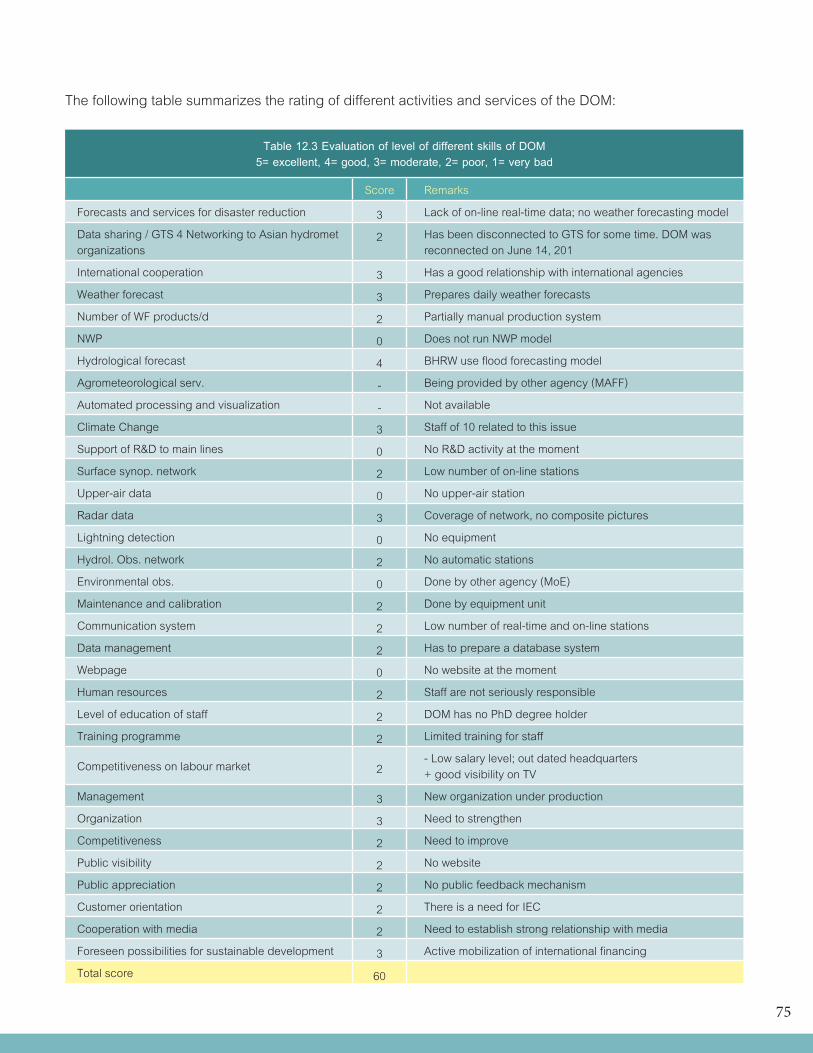
75
The following table summarizes the rating of different activities and services of the DOM:
Table 12.3 Evaluation of level of different skills of DOM5= excellent, 4= good, 3= moderate, 2= poor, 1= very bad
Score Remarks
Forecasts and services for disaster reduction 3 Lack of on-line real-time data; no weather forecasting model
Data sharing / GTS 4 Networking to Asian hydromet organizations
2 Has been disconnected to GTS for some time. DOM wasreconnected on June 14, 201
International cooperation 3 Has a good relationship with international agencies
Weather forecast 3 Prepares daily weather forecasts
Number of WF products/d 2 Partially manual production system
NWP 0 Does not run NWP model
Hydrological forecast 4 BHRW use flood forecasting model
Agrometeorological serv. - Being provided by other agency (MAFF)
Automated processing and visualization - Not available
Climate Change 3 Staff of 10 related to this issue
Support of R&D to main lines 0 No R&D activity at the moment
Surface synop. network 2 Low number of on-line stations
Upper-air data 0 No upper-air station
Radar data 3 Coverage of network, no composite pictures
Lightning detection 0 No equipment
Hydrol. Obs. network 2 No automatic stations
Environmental obs. 0 Done by other agency (MoE)
Maintenance and calibration 2 Done by equipment unit
Communication system 2 Low number of real-time and on-line stations
Data management 2 Has to prepare a database system
Webpage 0 No website at the moment
Human resources 2 Staff are not seriously responsible
Level of education of staff 2 DOM has no PhD degree holder
Training programme 2 Limited training for staff
Competitiveness on labour market 2- Low salary level; out dated headquarters+ good visibility on TV
Management 3 New organization under production
Organization 3 Need to strengthen
Competitiveness 2 Need to improve
Public visibility 2 No website
Public appreciation 2 No public feedback mechanism
Customer orientation 2 There is a need for IEC
Cooperation with media 2 Need to establish strong relationship with media
Foreseen possibilities for sustainable development 3 Active mobilization of international financing
Total score 60

76
13 RECOMMENDATIONS TO STRENGTHEN THE HYDROMETEOROLOGICAL SERVICES
Based on the assessment of the current status of DOM, there is a big gap to fill to meet the requirements for hydrometeorological services. First and foremost is the human resource. It has been observed that the DOM staffs do not have a strong sense of responsibility to work. Many do not report to work on time; others just come and go as they wish. The salary rate of government employees is not competitive with the private companies. The government should find ways to address this through award of incentives such as scholarship grants, free medical services, low-cost housing projects and other benefits. Another issue on human resources is the lack of trained personnel to do the technical jobs hence, capacity building is necessary. The second major concern is on physical resource. DOM compared to other Asian countries is way far behind in terms of technical equipment/instruments and facilities.
To be able to fill the gaps and meet the requirements of good hydrometeorological service, the following recommendations are made:
1) Adequate networks to monitor hydrometeoro- logical parameters •Upgrade or modernize DOM stations / instru- ments together with data communication network (domestic links): •automationofraingaugestations; •automationofsynopticstations; •Establish stations for upper air sounding facilities, with training of professional staff •Improveprecisioninrainfallmonitoring; •Upgradesurfacemainstationaby introducing automatic weather station (AWS); convert manual (analogue) instruments to digital; •Automate thehydrologicalstations (water level gage, rain gage); •Increase the number of on-line hydro- meteorological stations;
•Improvethequalityofobservations,equipment maintenance, automatic quality control and data management; •Enhance Severe Weather monitoring and forecasting capability, especially for typhoon when it approaches Indochina Peninsula;
2) Robust communication system for data trans- mission, disseminate of forecasts and sharing of information •UpgradecommunicationfromHFtoGSMfrom field stations to HQ; •Establish tools (hardware & software) for climatological applications with training of professional staff; •Establishvisualizationdisplaysystem; •Facilitate exchange of real time rainfall data observation during passage of Typhoon.
77
•Integrated decision and information system to forecast severe hydrometeorological and environmental events;
3) High speed computing system for data assimilation and ensemble forecasting •Promote IT-supported data collection, smooth and user friendly data management of all data, and automated manufacturing of products; The data collected from the automatic stations could be based on GPRS system in order to reduce communication costs;
4) Human resources •Capacitate the DOM staff through advance studies and technical training of the professional and sub-professional staff; •Activate the R&D arm to produce studies that would be useful for operational forecasting, the DOM and DHRW need to be restructured and given financial autonomy in planning and implementation of their own programmes
5) More interaction with users of weather and climate information •Strengthen its collaboration with local and national agencies particularly those involved in disaster management and environmental issues like climate change; •Planactivities incooperationwithstakeholders and end-users to promote collection, sharing and use of data, extending their use to meet local, regional and international demand; •Promote theroleofDOMas the focalpoint for Early Warning System; •RaisethevisibilityofDOM,throughcollaborative projects with the media i.e. IEC campaign; and •Improve cooperation and data sharing with agriculture, energy, transportation, road sector and other sectors providing hydro-meteorological and environmental data;
•Promote cooperation and data sharing with neighboring countries particularly radar, upper- air and other meteorological data; •Request WMO to establish Sub-Regional Forecast Support Center that provides Severe Weather guidance to Southeast Asian country; •Strengthen collaboration with regional and international organization in term of disaster prevention and mitigation;
The DOM and DHRW must start to plan for their medium to long term human resources development. Both departments need to reorganize their space needs to be able to manage their assets.
DHRW and DOM must be decentralized to a number of hydromet centers in different locations of the country.
78
14 PROJECT PROPOSAL
Based on the assessment of the DOM, there are needs to be addressed to strengthen the basic weather services in Cambodia. Strategies include upgrading of meteorological instruments and equipment; improvement of network density of monitoring stations, establishment of a good real-time communication system, activation of research and development studies for the advancement of the operational activities of the agency and capacity building of its personnel. The weather forecasting is ineffective unless it is used for flood/drought forecasting, in collaboration with the DHRW and the MRC’s Regional Flood Management and Mitigation Centre (RFMMC). Flood/drought forecasting must expand far beyond current covering areas of only mainstream to cover also tributaries to serve the real need of the people for their day to day planning and concerned economic sectors to adapt their plan accordingly.
To allow appropriate time for DOM and DHRW to develop and strengthen their institutional and human resources capacity, a medium to long term plan must be carefully considered since past experiences have shown that main causes of equipment failures were inadequate training, poor management, lack of staff’s motivation and lack of learning environment in both departments. There are very significant professional generation gaps of some twenty years and shortage of qualified staffs at all level including lack of leadership. Another critical issue is that the MOWRAM is not able to retain qualified staffs due to its centralized system, lack of appropriate staff’s policy and managers in key departments. To bring a significant change, it might need up to 20 years divided into two phases.
The first ten years will be an adjustment plan that could be subdivided into two periods of five years each. The first five years would be to focus on the restructuration planning of the DOM and DHRW in line with the Policy and Institutional Reform and Capacity Development in Water Sector of the MOWRAM. In parallel with the medium to long term planning process which will include institutional capacity building, human resource development will be planned and implemented under the plan. Capacity strengthening of existing staffs will be progressively made to support effective operation of invested equipment namely the Doppler radar system, the installation and put into operation of (i) the 10 set of semi-automatic weather stations provided by ADPC in 2009, (ii) the review and installation of 800 manual rainfall stations with near real time data transmission, (iii) the initiation of the flood/drought forecasting in major tributaries by DHRW and (iv) the training plan for professional hydrologists and meteorologists including the reestablishment and restructuring of the DOM and DHRW human resources.
Similarly the DHRW shall re-establish its medium to long term plan to maintain existing stations and related infrastructure; to review the status of exiting stations and expand the network to cover ungauged sub-basins; to expand activities towards operational hydrology rather than sticking to hydrometry, as usual. The expected outcome of the first phase of the DHRW would be to begin the integration of the national water resource planning and management into their annual plan. This includes the provision of regular water resource status (annual) of all 39 sub-basins in the country, initiating a support programme for water law and related sub-decrees development, implementation and the programme
79
for flood/drought, river monitoring in each of the sub-basins and initiating the application of the integration of the radar data and synoptic data into the day to day water resource management including the downscaling of potential impact of climate change for use in development of policy and strategy for climate change adaptation.
During this first five years phase, both departments will require adequate logistics supply for their field works and facilities for their need handling and management of technical equipments (store rooms, calibration maintenance facilities), appropriate physical space for new installation (upper air stations, new standard synoptic stations, training centres etc. (DOM within the new site of synoptic stations), and the DHRW in the compound of the MRC.
Building on the success of the first phase, in the second five years period, both departments should work more closely together while strengthening their business relationship with potential data users. The second 10 years period is the full business development period which at the end, both departments will be fully financed by the government and their own generated incomes.
Early in the second 10 years period, it is envisaged that five Hydromet Centers will be established (Kratie, Kampong Thom, Pursat, Sihanoukville and Prey Veng).
The following 5-year project proposal is based on the requirements for disaster reduction and management of DOM services in Cambodia.
14.1 International cooperation
As a least developed country (LDC) recovering from war, the DOM will be most benefited by the enhancement of international cooperation and networking.
Activities: International cooperation, attendance/participation at meetings & conferencesBudget: US$200,000
14.2 Telecom, IT andData management
Taking into account the JICA proposal (Table 14.2), the estimated budget for 5 years is as follows:
Telecom IT Center Data Management
Hardware + software 600,000 150,000 610,000
Consultation & training 50,000 100,000
Storage 30 TB 125,000
Additional staff 25,000*
TOTAL 600,000*** 225,000 835,000
* Shall be shouldered by DOM.***The communication network will be upgraded from HF to GSM. This will involve telecommunication system of about 400 field stations to headquarters.
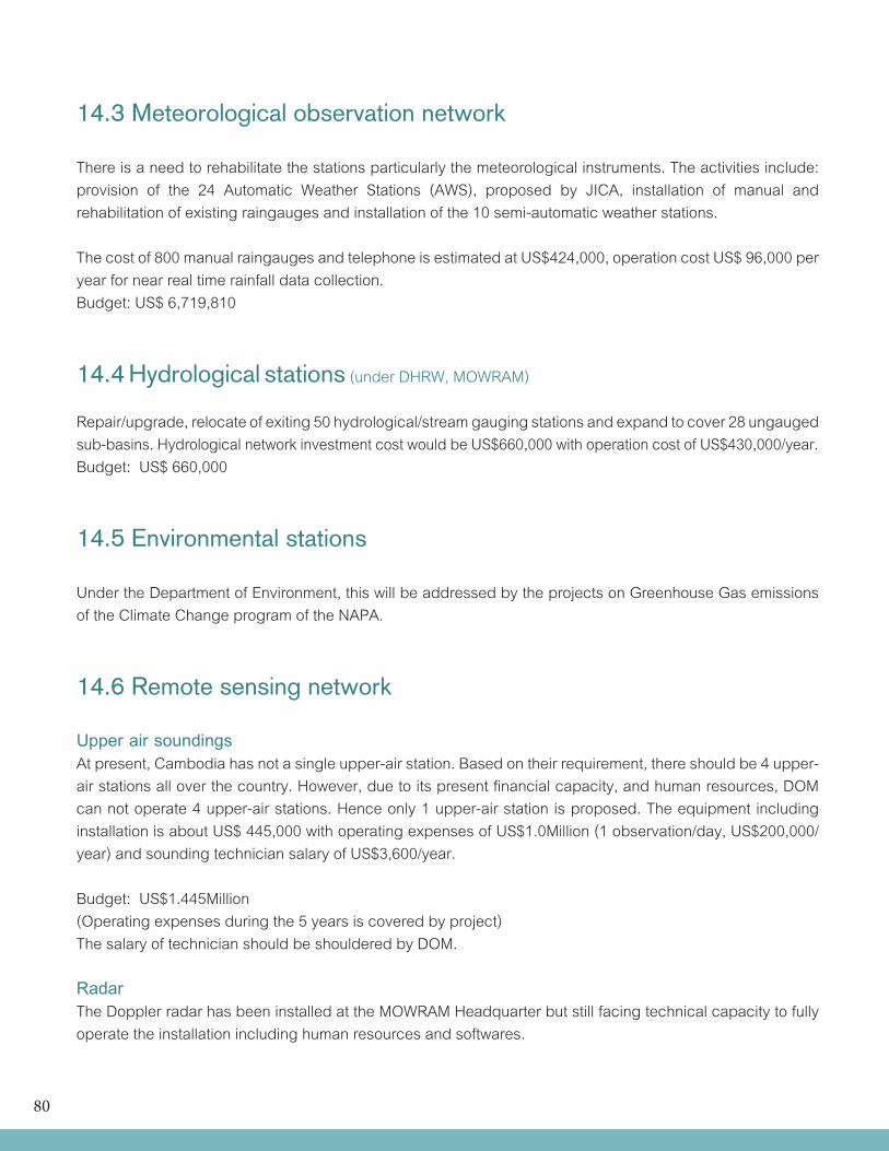
80
14.3 Meteorological observation network
There is a need to rehabilitate the stations particularly the meteorological instruments. The activities include: provision of the 24 Automatic Weather Stations (AWS), proposed by JICA, installation of manual and rehabilitation of existing raingauges and installation of the 10 semi-automatic weather stations.
The cost of 800 manual raingauges and telephone is estimated at US$424,000, operation cost US$ 96,000 per year for near real time rainfall data collection. Budget: US$ 6,719,810
14.4 Hydrological stations (under DHRW, MOWRAM)
Repair/upgrade, relocate of exiting 50 hydrological/stream gauging stations and expand to cover 28 ungauged sub-basins. Hydrological network investment cost would be US$660,000 with operation cost of US$430,000/year.Budget: US$ 660,000
14.5 Environmental stations
Under the Department of Environment, this will be addressed by the projects on Greenhouse Gas emissions of the Climate Change program of the NAPA.
14.6 Remote sensing network
Upper air soundingsAt present, Cambodia has not a single upper-air station. Based on their requirement, there should be 4 upper-air stations all over the country. However, due to its present financial capacity, and human resources, DOM can not operate 4 upper-air stations. Hence only 1 upper-air station is proposed. The equipment including installation is about US$ 445,000 with operating expenses of US$1.0Million (1 observation/day, US$200,000/year) and sounding technician salary of US$3,600/year. Budget: US$1.445Million (Operating expenses during the 5 years is covered by project)The salary of technician should be shouldered by DOM.
RadarThe Doppler radar has been installed at the MOWRAM Headquarter but still facing technical capacity to fully operate the installation including human resources and softwares.
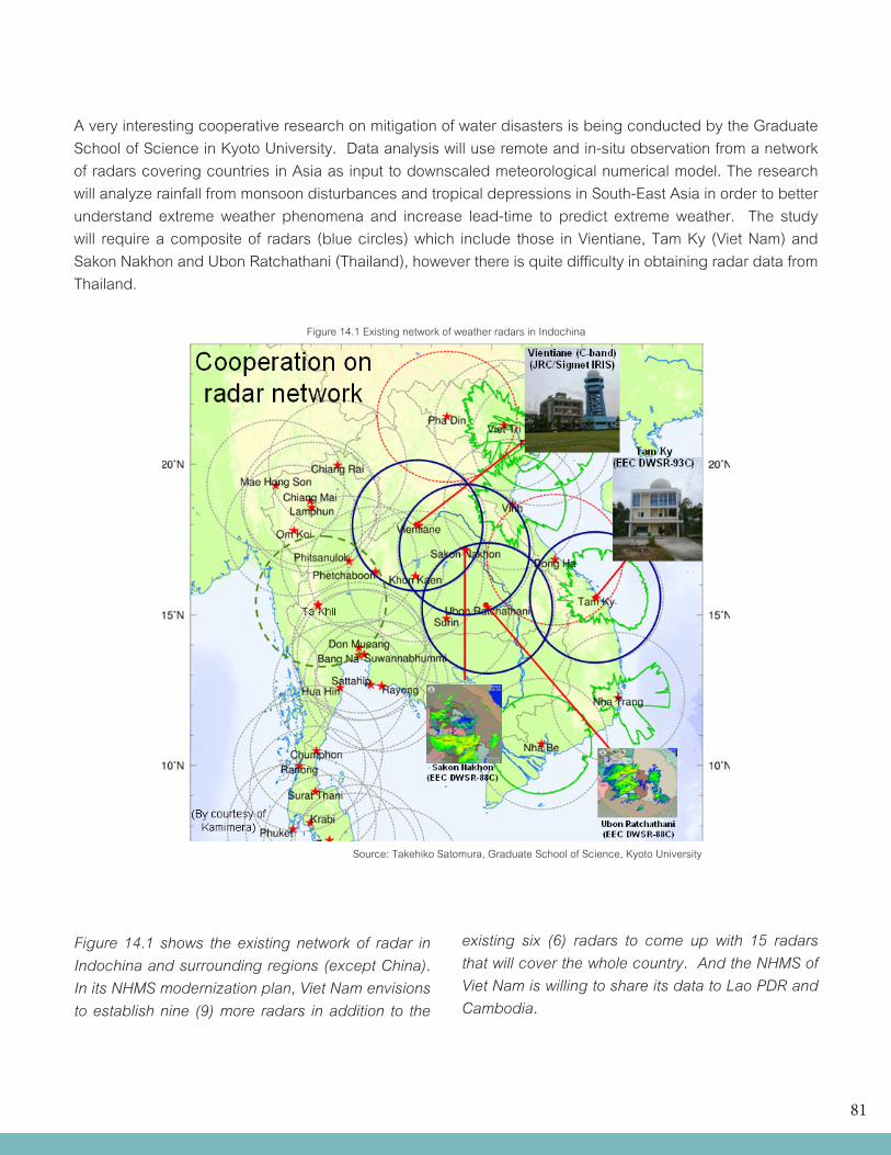
81
A very interesting cooperative research on mitigation of water disasters is being conducted by the Graduate School of Science in Kyoto University. Data analysis will use remote and in-situ observation from a network of radars covering countries in Asia as input to downscaled meteorological numerical model. The research will analyze rainfall from monsoon disturbances and tropical depressions in South-East Asia in order to better understand extreme weather phenomena and increase lead-time to predict extreme weather. The study will require a composite of radars (blue circles) which include those in Vientiane, Tam Ky (Viet Nam) and Sakon Nakhon and Ubon Ratchathani (Thailand), however there is quite difficulty in obtaining radar data from Thailand.
Source: Takehiko Satomura, Graduate School of Science, Kyoto University
Figure 14.1 Existing network of weather radars in Indochina
Figure 14.1 shows the existing network of radar in Indochina and surrounding regions (except China). In its NHMS modernization plan, Viet Nam envisions to establish nine (9) more radars in addition to the
existing six (6) radars to come up with 15 radars that will cover the whole country. And the NHMS of Viet Nam is willing to share its data to Lao PDR and Cambodia.
82
Satellite receiving stationAcquire one (1) additional satellite receiving facility, Fengyun Cast from ChinaBudget: US$135,000
14.7 Visualization display system
As an aide to forecasters in weather prediction, a visualization display system i.e. SYNERGIE is a necessity. This would facilitate fast and proper analysis of weather charts and NWP products to meet the growing demands of the different sectors of society.Budget: US$400,000
Website DevelopmentDOM has no existing website at present. To enhance its visibility, a website showcasing its services should be developed.Budget: US$50,000
14.8 Lightning detection system
As per report of NDCM, the number of deaths due to lightning has been increasing for the past year. At present, Cambodia has no lightning detector so there is also a need to put up about 3 lightning stations but these can be integrated in the network of AWS. Budget: US$10,500
14.9 Climate change
Conduct studies on climate change including seminars in cooperation with Ministry of Environment and Ministry of Agriculture, Forestry and Fishery. Budget: US$100,000
14.10 Training
Additional assistance is also required for the development of forecasting system through support for human resources development. This will include training of personnel on climate change, numerical modelling, disaster management, etc. Trainings on IT, equipment operations and maintenance, they are incorporated in the budget for IT, telecom and data management.Budget: US$ 100,000
In addition, two professional training programmes are proposed: 1) postgraduates/master degrees (to seek scholarships), 2) Bachelor degree at ITC, which requires additional lecturers in Hydrology and Meteorology; Technician in Hydrology and Meteorology (CL3 at ITC) and Technician CL4 at a vocational school. The training will not only target the need of the DHRW and DOM but also the universities and the media. It is proposed to train for the next ten years:
• Hydrologists:Msc/Postgraduates(13),Bachelor (16) Technician CL3(65), Technician CL4 (40). • Meteorologist: Msc/Post graduates (14) Bachelor (21), Technician CL3 (40), Technician CL4 (48)
Estimated cost: US$ 2,500,000.
The summary of proposed activities and corresponding budgetary requirements as stand alone organization is listed in Table 14.1 with Column A a “Stand alone “ system and Column B with regional cooperation.
83
Table 14.1 Distribution of the costs of a 5 year project in the case all the investments are done in the first year
CAMBODIA A (USD) B (USD)International cooperation of experts 200,000 100,000
Communication systems
•Hardware+software 600,000 600,000IT Center •Hardware 150,000 150,000•Consulting 50,000 50,000•ITstaff(byDOM) Salary by DOM: 25,000
Data management
•Hardwareandinstallation 610,000 610,000•Storage30TB 125,000 125,000•Consultationandtraining 100,000 50,000Meteorological observation network•24AutomaticWeatherStationsandtraining 6,309,590 6,309,590•Installationofmanualandrehabilitationofexistingraingauges 400,000 400,000•Installationof10Semi-automaticweatherstations 10,220 10,220Hydrological observation network •Automatichydrologicalstations•Upgradedandexpansionofnewstations
550,000110,000
550,000110,000
Remote sensing network •Upperairobservations 445,000 445,000•Soundingtechnicians Salary by DOM: 20,000•Upper-airoperationandmaintenance(5years) 1,000,000 1,000,000•Newweatherradars(includingtowers) 6,200,000 2,050,000•Radartechnicians Salary by DOM: 20,000•Lightningdetection 10,500 10,500•Satellitereceivingstation 135,000 135,000Calibration and maintenance 100,000 75,000Forecasting and manufacturing tools •Visualizationsystem 400,000 400,000•Training 20,000 10,000•Stafftopromote24/7/365 Salary by DOM: 40,000Capacity Building•Trainingandcapacitybuildingforstaff 100,000 50,000•Formaltrainingofprofessionalstaffs 2,500,000 2,500,000Research and development •Impactsofclimatechange 100,000 50,000•Socioeconomicimpacts 100,000 50,000•Nationalseminaronsocio-economicbenefits 100,000 100,000•End-userseminar 75,000 20,000Website 50,000 30,000Project management •Consultant 200,000 100,000•Localprojectcoordinator 100,000 100,000Total 20,850,310 16,190,310
84
Table 14.2: JICA Proposal for the provision of 24 Automatic Weather Station (AWS)For the Improvement of Meteorological Observation in Cambodia
Summary:
1. Installation of the 24 AWS US$ 2,877,020.00
2. Domestic Telecommunication Systems US$ 369,020.00
3. Upgrading the GTS Information Systems US$ 530,090.00
4. Improvement of weather forecasting tools US$ 296,470.00
5. Community Warning Facility US$ 190,820.00
6. Domestic Data Gathering and Distribution Systems US$ 1,327,730.00
7. Calibration System for Meteorological measuring equipment and networks US$ 450,990.00
8. Vehicles for maintenance on site AWS stations US$ 167,500.00
9. Digitizing historical meteorological data of Cambodia US$ 99,950.00
GRAND TOTAL US$ 6,309,590
Detailed proposal:
1) Installation of the 24 AWS
Classification Item Cost (US$)
Facilities(1)Observatory shed (building) 30,000.00
Sensor pole & Foundation base 17,330.00
Sub-total 47,330.00
Equipment(2)
Weather Sensors 28,960.00
AWS data logger 9,900.00
Solar Power Supply System 24,520.00
Communication devices 1,440.00
Accessories & Spare parts 5,460.00
Sub-total 70,280.00
Soft (Non-physical) components(3)
Training course for operations 30,000.00
Training course for maintenance 20,000.00
Sub-total 50,000.00
Design/Supervision(4) 4,380.00
Total 1 (1)+(2)x 24 sites + (3)+(4) 2,877,020.00
85
2) Domestic Telecommunication Systems
Classification Item Cost (US$)
FacilitiesAntenna towers (30m) 133,300.00
Foundation base 26,670.00
Sub-total 159,970.00
Equipment
Radio-wave telemetry system 28,800.00
Microwave communications 126,140.00
GPRS communication devices 3,200.00
DCP satellite communications 8,030.00
Accessories & Spare parts 16,610.00
Sub-total 182,780.00
Soft (Non-physical) components
Training course for operation 3,650.00
Training course for maintenance 5,480.00
Sub-total 9,130.00
Design/Supervision 17,140.00
Total 2 369,020.00
3) Upgrading the GTS Information Systems
Classification Item Cost (US$)
Equipment
Message Switching Systems 240,000.00
Upgrading software for TDCF 160,000.00
Connection with 2nd RTH 48,000.00
Communication equipment 9,600.00
AC power backup system (UPS) 8,000.00
Accessories & Spare parts 25,750.00
Sub-total 491,350.00
Soft (Non-physical) components
Training course for operation 14,740.00
Training course for maintenance 9,830.00
Sub-total 24,570.00
Design/Supervision 14,170.00
Total 3 530,090.00
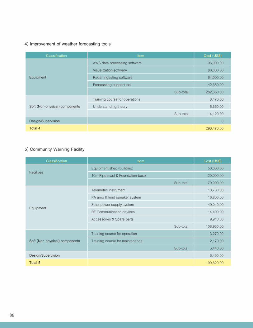
86
4) Improvement of weather forecasting tools
Classification Item Cost (US$)
Equipment
AWS data processing software 96,000.00
Visualization software 80,000.00
Radar ingesting software 64,000.00
Forecasting support tool 42,350.00
Sub-total 282,350.00
Soft (Non-physical) components
Training course for operations 8,470.00
Understanding theory 5,650.00
Sub-total 14,120.00
Design/Supervision 0
Total 4 296,470.00
5) Community Warning Facility
Classification Item Cost (US$)
FacilitiesEquipment shed (building) 50,000.00
10m Pipe mast & Foundation base 20,000.00
Sub-total 70,000.00
Equipment
Telemetric instrument 18,780.00
PA amp & loud speaker system 16,800.00
Solar power supply system 49,040.00
RF Communication devices 14,400.00
Accessories & Spare parts 9,910.00
Sub-total 108,930.00
Soft (Non-physical) components
Training course for operation 3,270.00
Training course for maintenance 2,170.00
Sub-total 5,440.00
Design/Supervision 6,450.00
Total 5 190,820.00
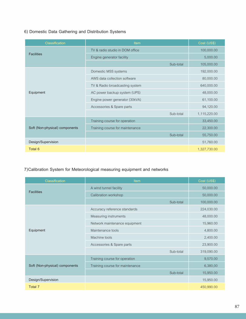
87
6) Domestic Data Gathering and Distribution Systems
Classification Item Cost (US$)
FacilitiesTV & radio studio in DOM office 100,000.00
Engine generator facility 5,000.00
Sub-total 105,000.00
Equipment
Domestic MSS systems 192,000.00
AWS data collection software 80,000.00
TV & Radio broadcasting system 640,000.00
AC power backup system (UPS) 48,000.00
Engine power generator (30kVA) 61,100.00
Accessories & Spare parts 94,120.00
Sub-total 1,115,220.00
Soft (Non-physical) components
Training course for operation 33,450.00
Training course for maintenance 22,300.00
Sub-total 55,750.00
Design/Supervision 51,760.00
Total 6 1,327,730.00
7) Calibration System for Meteorological measuring equipment and networks
Classification Item Cost (US$)
FacilitiesA wind tunnel facility 50,000.00
Calibration workshop 50,000.00
Sub-total 100,000.00
Equipment
Accuracy reference standards 224,030.00
Measuring instruments 48,000.00
Network maintenance equipment 15,960.00
Maintenance tools 4,800.00
Machine tools 2,400.00
Accessories & Spare parts 23,900.00
Sub-total 319,090.00
Soft (Non-physical) components
Training course for operation 9,570.00
Training course for maintenance 6,380,00
Sub-total 15,950.00
Design/Supervision 15,950.00
Total 7 450,990.00
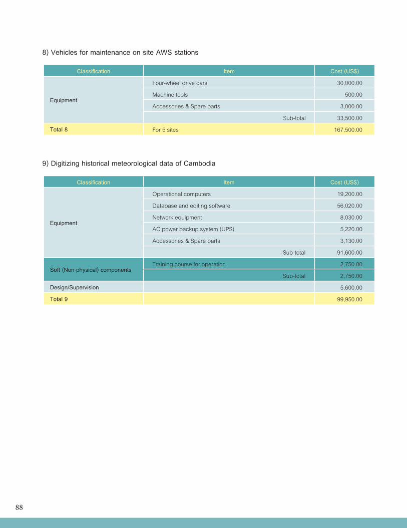
88
8) Vehicles for maintenance on site AWS stations
Classification Item Cost (US$)
Equipment
Four-wheel drive cars 30,000.00
Machine tools 500.00
Accessories & Spare parts 3,000.00
Sub-total 33,500.00
Total 8 For 5 sites 167,500.00
9) Digitizing historical meteorological data of Cambodia
Classification Item Cost (US$)
Equipment
Operational computers 19,200.00
Database and editing software 56,020.00
Network equipment 8,030.00
AC power backup system (UPS) 5,220.00
Accessories & Spare parts 3,130.00
Sub-total 91,600.00
Soft (Non-physical) componentsTraining course for operation 2,750.00
Sub-total 2,750.00
Design/Supervision 5,600.00
Total 9 99,950.00
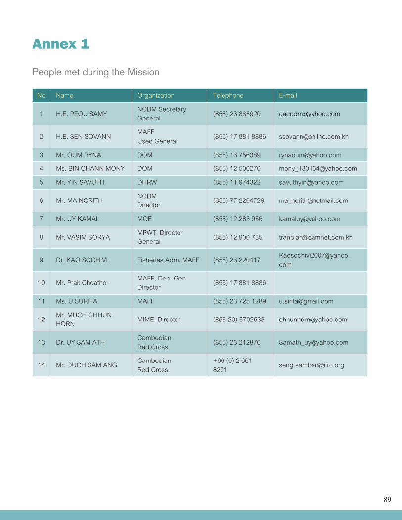
89
Annex 1
People met during the Mission
No Name Organization Telephone E-mail
1 H.E. PEOU SAMY NCDM Secretary General (855) 23 885920 [email protected]
2 H.E. SEN SOVANN MAFFUsec General (855) 17 881 8886 [email protected]
3 Mr. OUM RYNA DOM (855) 16 756389 [email protected]
4 Ms. BIN CHANN MONY DOM (855) 12 500270 [email protected]
5 Mr. YIN SAVUTH DHRW (855) 11 974322 [email protected]
6 Mr. MA NORITH NCDMDirector (855) 77 2204729 [email protected]
7 Mr. UY KAMAL MOE (855) 12 283 956 [email protected]
8 Mr. VASIM SORYA MPWT, Director General (855) 12 900 735 [email protected]
9 Dr. KAO SOCHIVI Fisheries Adm. MAFF (855) 23 220417 [email protected]
10 Mr. Prak Cheatho - MAFF, Dep. Gen. Director (855) 17 881 8886
11 Ms. U SURITA MAFF (856) 23 725 1289 [email protected]
12 Mr. MUCH CHHUN HORN MIME, Director (856-20) 5702533 [email protected]
13 Dr. UY SAM ATH CambodianRed Cross (855) 23 212876 [email protected]
14 Mr. DUCH SAM ANG CambodianRed Cross
+66 (0) 2 661 8201 [email protected]
90
References
Hautala, R., P. Leviakangas, J. Rasanen, R. Oorni, S. Sonninen, P. Vahanne, M. Hekkanen, M. Ohlstrom, S. Saku, B. Tammelin and A. Venalainen. 2008. of Meteorological Services in South Eastern Europe: An Assessment of Potential Benefits in Albania, Bosnia-Herzegovina, FYR Macedonia, Moldova and Montenegro. VTT Technical Research Centre of Finland and FMI Finnish Meteorological Institute, VTT Working Papers 109. p. 63.
Leviakangas, P., R. Hautala, J. Rasanen, R. Oornie, S. Sonninen M. Hekkanen, M. Ohlstrom, A. Venalainen and S. Sakku. 2007. Benefits of Meteorological Services in Croatia. VTT TIEDOTTEITA Research Notes 2420. P. 71.Tammelin, B. 2007. Country Profile: Serbia for the UN/ISDR Project “Strengthening of Hydrometeorological Services in South Eastern Europe.” In Cooperation with Staff of RHMSS. p. 115.
Zhuang, J., Zhihong, L., Tun, L. and F. De Guzman. 2007. Theory and Practice in the Choice of Social Discount Rate for Cost -benefit Analysis: A Survey. ERD Working Paper No. 94, Asian Development Bank. Manila, Philippines. p. 40.
Internet Sources:“Flood Forecasting and Warning System in Vulnerable Areas in Cambodia” by Long Saravuth, BHRW, MOWRAM, Presentation during the Workshop on Disaster Management for MDG, 5-9 Sept. 2005, Malaysia
The OFDA/CRED International Disaster Database. Retrieved from http://www.emdat.be/advanced-search
Mekong River Commission. Annual Flood Report Retrieved from http://www.mrcmekong.org/free_download/research.htm.
United Nations Statistics Division. Retrieved from http://data.un.org/Data.aspx?d=SNA&f=group_code%3a202
World Bank. World Development Indicators. Retrieved from http://www.gdnet.org/proxy/wdi.html
http://www.state.gov/r/pa/ei/bgn/2732.htm#profile
www.recambodia.org/biomass.htm
http://www.business-in-asia.com/cambodia/cambodia_constructions.html
http://www.zi-online.info/en/artikel/zi_CamBuild_2010_Cambodia_ InternationalBuilding_ Construction_Industry_Show_816447.html.
un.org.kh/undp/.../296-Cambodia-Project-Document-SLM.html
91
http://www.adb.org/Documents/Reports/Urban-Air-Quality-Management/cambodia.pdf, Country Synthesis Report on Urban Air Quality Management, Cambodia,
http://www.delkhm.ec.europa.eu/en/events/dec-22-09/005%20-%20Climate%20Change%20in%20Cambodia%20by%20Dr%20Tin%20Ponlok.pdf
http://en.wikipedia.org/wiki/Royal_Gendarmerie_of_Cambodia
(http://www.eoearth.org/article/Water_profile_of_Cambodia)
http://en.wikipedia.org/wiki/SWAT_model
http://www.water.nsw.gov.au/Water-Management/Modelling/River-systems/River-systems/default.aspx
http://www.mrcmekong.org/.../InterSWAT_IQQMOutput20-21May06modi_2.pdf
http://www.mot.gov.kh/GeneralInformation.aspx?sm=63&Ads=1
http://www.usaid.gov/kh/humanitarian_assistance.htm
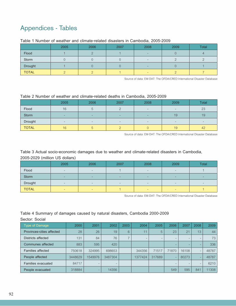
92
Appendices - Tables
Table 1 Number of weather and climate-related disasters in Cambodia, 2005-20092005 2006 2007 2008 2009 Total
Flood 1 2 1 - 0 4
Storm 0 0 0 - 2 2
Drought 1 0 0 - 0 1
TOTAL 2 2 1 - 2 7
Source of data: EM-DAT: The OFDA/CRED International Disaster Database
Table 2 Number of weather and climate-related deaths in Cambodia, 2005-2009 2005 2006 2007 2008 2009 Total
Flood 16 5 2 - - 23
Storm - - - - 19 19
Drought - - - - - -
TOTAL 16 5 2 0 19 42
Source of data: EM-DAT: The OFDA/CRED International Disaster Database
Table 3 Actual socio-economic damages due to weather and climate-related disasters in Cambodia,2005-2029 (million US dollars)
2005 2006 2007 2008 2009 Total
Flood - - 1 - - 1
Storm - - - - - -
Drought - - - - - -
TOTAL - - 1 - - 1
Source of data: EM-DAT: The OFDA/CRED International Disaster Database
Table 4 Summary of damages caused by natural disasters, Cambodia 2000-2009Sector: Social
Type of Damage 2000 2001 2002 2003 2004 2005 2006 2007 2008 2009
Provinces-cities affected 28 26 19 6 11 5 23 21 13 44
Districts affected 131 84 76 7 - - - - - 73
Communes affected 883 595 420 - - - 336
Families affected 750618 324995 698653 344356 71517 71870 16108 - 48787
People affected 3448629 1549976 3487304 1377424 317689 - 80273 - 48787
Families evacuated 84717 - - - - - 6210
People evacuated 318884 - 14356 549 595 841 11308
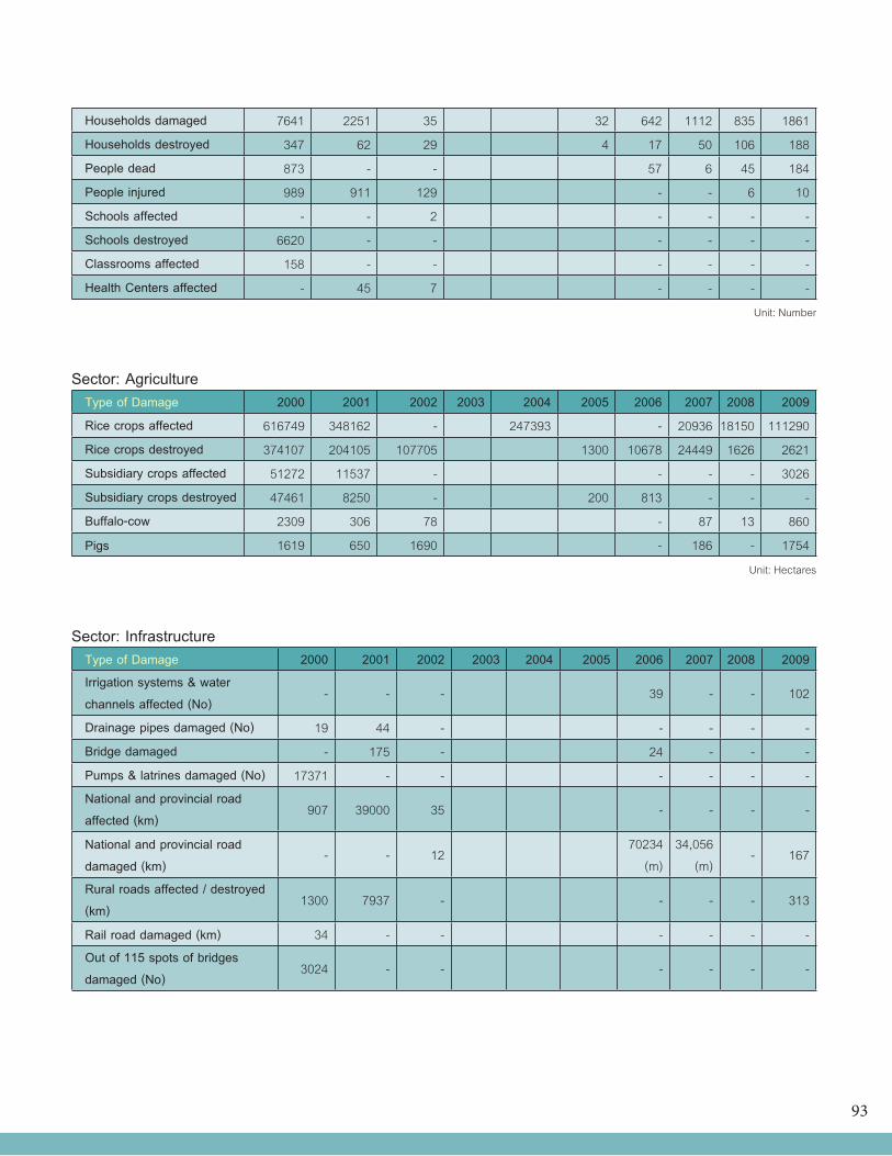
93
Households damaged 7641 2251 35 32 642 1112 835 1861
Households destroyed 347 62 29 4 17 50 106 188
People dead 873 - - 57 6 45 184
People injured 989 911 129 - - 6 10
Schools affected - - 2 - - - -
Schools destroyed 6620 - - - - - -
Classrooms affected 158 - - - - - -
Health Centers affected - 45 7 - - - -
Unit: Number
Sector: AgricultureType of Damage 2000 2001 2002 2003 2004 2005 2006 2007 2008 2009
Rice crops affected 616749 348162 - 247393 - 20936 18150 111290
Rice crops destroyed 374107 204105 107705 1300 10678 24449 1626 2621
Subsidiary crops affected 51272 11537 - - - - 3026
Subsidiary crops destroyed 47461 8250 - 200 813 - - -
Buffalo-cow 2309 306 78 - 87 13 860
Pigs 1619 650 1690 - 186 - 1754
Unit: Hectares
Sector: InfrastructureType of Damage 2000 2001 2002 2003 2004 2005 2006 2007 2008 2009
Irrigation systems & water channels affected (No)
- - - 39 - - 102
Drainage pipes damaged (No) 19 44 - - - - -
Bridge damaged - 175 - 24 - - -
Pumps & latrines damaged (No) 17371 - - - - - -
National and provincial road affected (km)
907 39000 35 - - - -
National and provincial road damaged (km)
- - 1270234
(m)34,056
(m)- 167
Rural roads affected / destroyed (km)
1300 7937 - - - - 313
Rail road damaged (km) 34 - - - - - -
Out of 115 spots of bridges damaged (No)
3024 - - - - - -
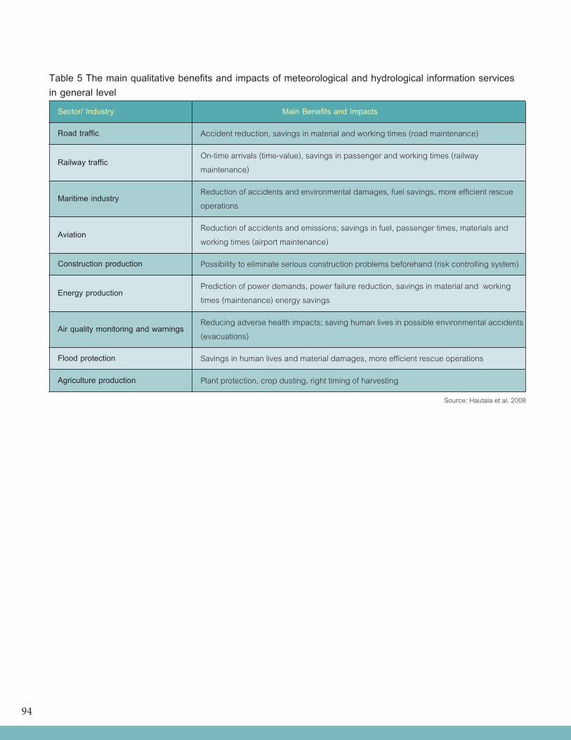
94
Table 5 The main qualitative benefits and impacts of meteorological and hydrological information servicesin general level
Sector/ Industry Main Benefits and Impacts
Road traffic Accident reduction, savings in material and working times (road maintenance)
Railway trafficOn-time arrivals (time-value), savings in passenger and working times (railway maintenance)
Maritime industryReduction of accidents and environmental damages, fuel savings, more efficient rescue operations
AviationReduction of accidents and emissions; savings in fuel, passenger times, materials and working times (airport maintenance)
Construction production Possibility to eliminate serious construction problems beforehand (risk controlling system)
Energy productionPrediction of power demands, power failure reduction, savings in material and working times (maintenance) energy savings
Air quality monitoring and warningsReducing adverse health impacts; saving human lives in possible environmental accidents (evacuations)
Flood protection Savings in human lives and material damages, more efficient rescue operations
Agriculture production Plant protection, crop dusting, right timing of harvesting
Source: Hautala et al. 2008