Embed Size (px)
Citation preview

Agenda
Introductions (2 min.)• Paul Tetrault - • Ralph Segal - • Lesley Beale -
1. The Need for Affordable Rental Housing (5 mins.)
2. Context, Project & Impact (10 mins.)
3. Transportation, Traffic & Access (5 mins.)
4. Policy & Process (5 mins.)
5. Our Requests (3 min.)• Proponent hosted Neighbourhood Open House• Update our Neighbourhood Plan before any Rezoning• Site Visit with Councillor(s) hosted by our Committee
6. Discussion/Questions (15 min.)

2400/2500 SE Marine & Elliott: Issues & Objections1. The Need for Affordable Housing:
We all agree that Vancouver needs more rental housing, particularly affordable rental, which should be produced in a way that doesn’t "destroy neighbourhoods” (Kennedy Stewart Vancouver Sun, Feb.15th). Ideally, large developments in presently low density areas would be in accordance with a new City-Wide Plan. This is obviously a balancing act and every project must be examined through the lens of this balancing act. We support the objectives of the Moderate Income Rental Housing Pilot Project (MIRHPP). However, in this specific case, MIRHPP’s stated site selection and urban design criteria as well as long established long standing planning and contextual principles, are being ignored.
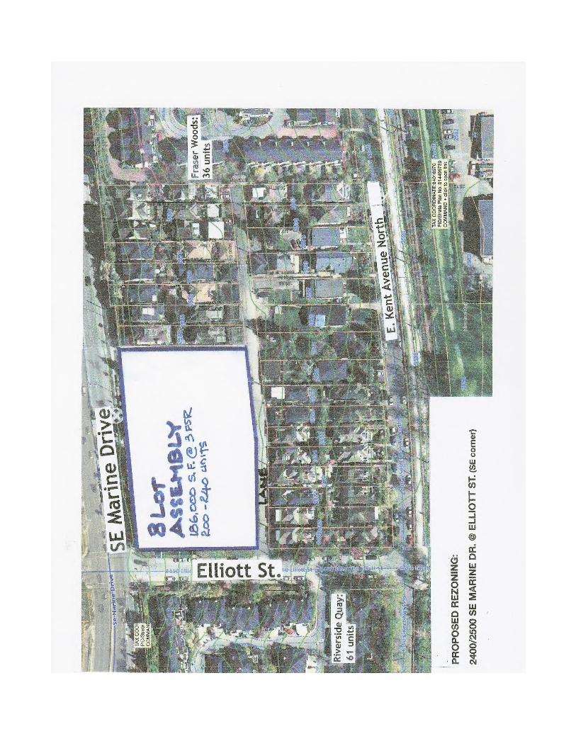
2. Context, Project & Impact:The Context: The Victoria-Fraserview/Killarney Community Vision adopted by Vancouver City Council in 2002 following extensive consultation with the community does not anticipate or support this proposal. The Community Vision stated that the character and scale of the comprehensively planned and urban designed West Fraserlands community should be maintained, an already moderately dense integrated mixture of single-family homes (RS-1B) and predominantly townhouse stratas, social, co-op and affordable rental housing (507 non-market units in 6 developments see page 4). No major changes were proposed other than to add community services and facilities. These services and facilities were never added. Any project of this size should be part of a revised comprehensive neighbourhood plan. See Appendix 1: Context & Project.The Project: This proposed spot rezoning proposal currently at the “enquiry stage” (the Project) is situated on the southeast corner of SE Marine Drive and Elliott Street in the West Fraserlands/Riverside Neighbourhood which, would require the demolition of 13 houses recently redeveloped as part of the RS-1B zone allowing 2 houses on 1 lot. The Project, as illustrated on the website of the architect (Leckie Studios) acting for the Proponent (Jason del Vicario), consists of two 6-storey U-shaped buildings on an 8-lot land assembly with up to 240 rental units pursuant to the MIRHPP. It is possible that only one building with 120 units will be in this spot rezoning project if the more extensive land assembly is not successful. The Project is in the 2400/2500 blocks of SE Marine and E. Kent N., zoned RS-1B. This unique Riverside RS-1B zone (with Riverside RS-1B Design Guidelines) was the forerunner of Vancouver’s laneway housing concept with 2 houses on a single lot.The Urban Design Impacts: The Project is too dense and massive for the neighbourhood and as such does not respect the immediate context or the transitions to its surrounding area including single-family houses as called for by MIRHPP. The Project will be built on the north-side of an existing east-west lane with an 8 metre (26 ft.) drop from SE Marine Drive to the lane. Thus the 6-storey building will feel like 8 storeys creating scale, overlook and privacy concerns for the 43 remaining houses in the block. The Project, at this density and height, is not appropriate in this location. The chosen form of development, with N/S oriented courtyards (vs. preferable E/W-oriented courtyards that would optimize sun access) pushes 6-storey building massing to the site’s east, west and south (lane) edges, thereby absolutely maximizing impact on immediately adjacent houses and neighbouring townhouse developments rather than transitioning down to its neighbours. See Appendix 2 for letters to Council and Staff that contain a detailed analysis of the Project.
3. Transportation, Traffic & Access: The Lane: The Project will cause serious traffic and safety concerns in the neighbourhood. The only access and egress to the Project will be through the dead end lane onto Elliott Street. Adding between 160 and 200 cars to the lane, which is already at capacity will seriously impact traffic in the lane including Elliott Street, which has a 15% slope, with traffic impacts extending onto East Kent Ave.

The Neighbourhood Road Network: East Kent Avenue N & S between Argyle and Elliott Streets is already busy with commuter traffic attempting to bypass congestion associated with the Knight Street Bridge/SE Marine Drive Interchange. This Project will increase the volume of traffic on local neighbourhood streets. The local street network is highly constrained and discontinuous with East Kent Ave. N & S jogging back and forth across the CPR rail line and East Kent N blocked east of Elliott Street to discourage commuter traffic. The Elliott and East Kent bikeways will also be impacted and the increased traffic will be a serious safety concern. Access to & Transit & Shopping: The Project site has limited access to public transit with a single bus line on SE Marine and is remote from shopping and services (nearest shopping is 2.4 kms away) which will compel future residents of this Project to be car-dependent. Other MIRHPP projects that we are aware of are being built adjacent to shopping and transportation. See Appendix 2 for letters to Council and Staff that contain a detailed analysis of the Project.
4. Policy & Process: Policy Changes & Process: The MIRHPP advances from the Rental 100 Program by requiring a minimum 20% affordability component and notably adds RS zones to those areas eligible for additional density and height. However, we are concerned about the elimination of several key site selection criteria for future housing projects including the need to be located near arterials with both north-south and east-west transit routes and within convenient walking distance to nearby shopping and services. This rezoning “enquiry” has been dealt with by Staff for over a year. The proposed development and all aspects of it other than its 3 FSR density, 6-storey height and number of units (240) remain confidential. A Neighbourhood Petition objecting to this proposed development was signed by at least 243 neighbourhood property owners and submitted to Staff (see Appendix 3). A neighbourhood committee has now been formed, the West Fraserlands/S. Elliott Neighbourhood Committee. A Neighbourhood Flyer has been circulated (see Appendix 4). Given the level of neighbourhood concern regarding this proposed development, the lack of communication either from the City or the Proponent is disturbing.
5. Our Requests: Public Open House: We request that Council instruct Staff to direct the Proponent (see Appendix 5) to host a public open house that includes details of the proposed development with Staff in attendance.Neighbourhood Plan: If the City intends to pursue this Project or this extent of additional density in our neighbourhood ahead of a new City-Wide Plan, we request that Council instruct Staff to immediately undertake a focused Neighbourhood Plan before any rezoning application can be considered.Site Visit: We request and cordially invite any and all Councillors and Staff to visit this site and our West Fraserlands/S. Elliott Neighbourhood Committee would be happy host this site visit.
6. Appendices: Appendix 1: The Context & Project - page 4Appendix 2: Recent Correspondence - page 14Appendix 3: Neighbourhood Petition - page 29Appendix 4: Neighbourhood Flyer - page 33Appendix 5: Globe & Mail Article regarding the Proponent - page 35Appendix 6: Summary of Neighbourhood Strata Corps & Co-ops - page 39
Riverside Neighbourhood Co-ops,Social and Affordable Housing - Total 507 Unit• Longwater Place Family Housing: 1768 East Kent S., 42 units (BC Housing• Marin Vista Co-op: 8430 Duff St/2100 Southside Dr., 54 units• Riverside Landing Co-op: 2288 Lower Skipper Pl., 58 units• Fraser Lands Family Housing Co-op 2680 East Kent N. 43 units (Red Door Housing)• Vancouver Land Trust Affordable Housing: 2780/2800 SE Marine Dr., 220 units (including shelter-level)• Vancouver Land Trust Co-op: 2910 East Kent S., 90 units

Appendix 1: The Context & Project
This Appendix contains:1 Context Plan of the immediate area surrounding the proposed development site;1 Site Plan based on assumptions from the Architect’s renderings; 1 X-Section through the proposed development site based on the Architect’s renderings; 3 Architectural Renderings (from the Leckio Studio Architecture + Design website) including a view of the proposed site from along SE Marine Drive, two proposed courtyard images and one view looking north between the 2 proposed 6-storey buildings.
�

Approximated site plan of the proposed development extending from SE Marine Drive on the north to the east-west lane on the south, illustrating two proposed 6-storey U-shaped buildings containing up to 240 rental units.
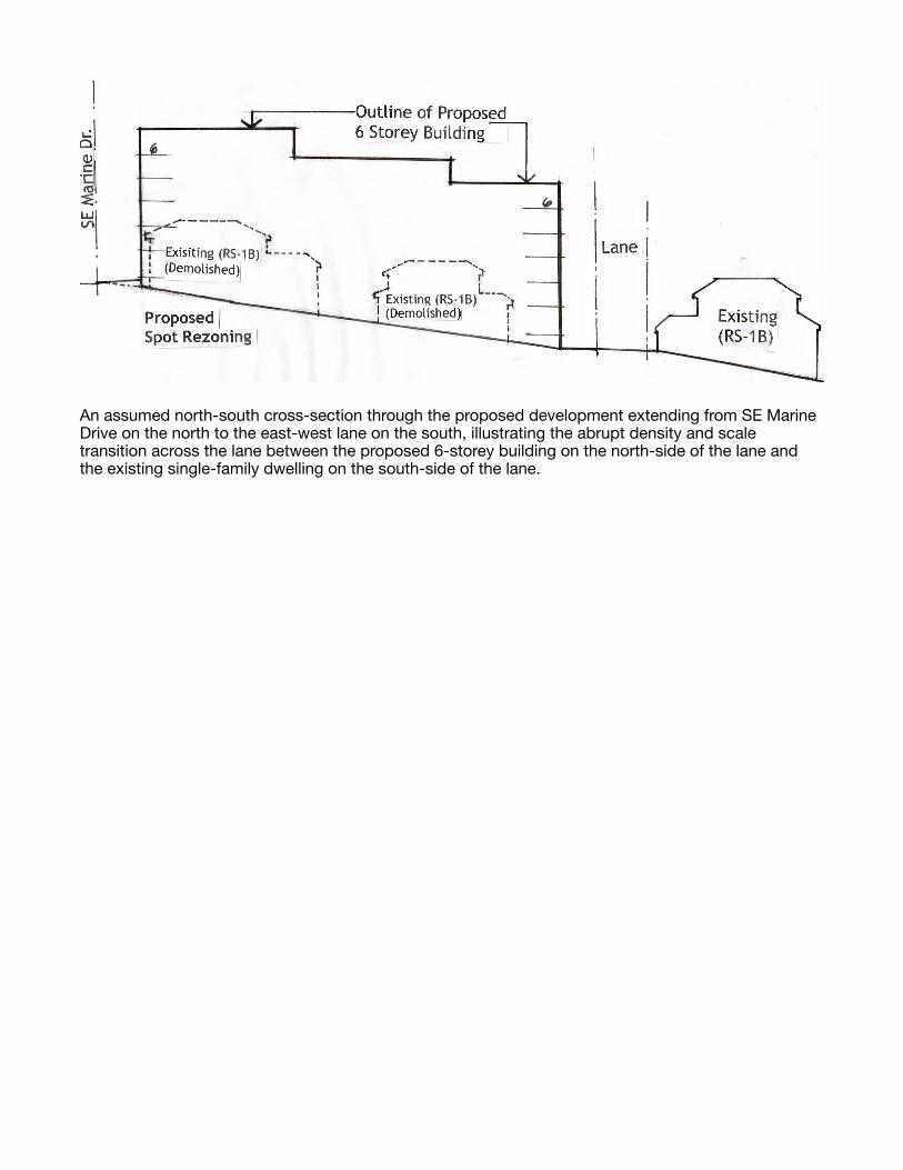
An assumed north-south cross-section through the proposed development extending from SE Marine Drive on the north to the east-west lane on the south, illustrating the abrupt density and scale transition across the lane between the proposed 6-storey building on the north-side of the lane and the existing single-family dwelling on the south-side of the lane.

Architect’s Visualization (Leckie Studio Architecture + Design)View looking east along SE Marine Drive near Elliott Street illustrating two proposed 6-storey buildings located on the southeast corner of the SE Marine Drive and Elliott Street intersection.

Architect’s Visualization (Leckie Studio Architecture + Design)View looking north into the common open space of one proposed 6-storey U-shaped building illustrating a landscaped courtyard for the use of the residents in the proposed rental development.

Architect’s Visualization (Leckie Studio Architecture + Design)View looking north into courtyard of one of the two proposed 6-storey U-shaped building for the use of the residents in the proposed multi-family rental development.

Architect’s Visualization (Leckie Studio Architecture + Design)View looking north between the two proposed 6-storey U-shaped buildings illustrating a pedestrian walkway connection between the existing east-west lane and SE Marine Drive.

Appendix 2: Recent Correspondence
2.1 Initial Letter to Staff - May 30, 2018
2.2 Initial Letter to Councillors - November 9, 2018
3.3 Follow-up Email & Letter to Staff - March 14, 2019
Appendix 2.1: Initial Letter to Staff - May 30, 2018May 30, 2018
Karen Hoese, Assistant Director - Rezoning Centre Michelle McGuire, Senior Planner Karima Mulji, Projects & Development Services - Engineering Dan Garrison, Assistant Director - Housing Policy Zak Bennett, Planner - Vancouver South
City of Vancouver Planning Department, 515 W 10th Avenue, Vancouver, BC V5Z 4A8
Pre-Enquiry Rezoning Proposal: 2400/2500 SE Marine Dr. and Elliott St. (southeast corner)
We are writing to express our concern regarding a pre-enquiry rezoning proposal from present RS-1B zoning at 2.5 storey height and 0.75 FSR to a 6-storey, 3.0 FSR residential rental development at the above location involving a site assembly of up to 13 lots (including up to 24 present owners). See location plan attached. As a preface to our concerns, we applaud the City’s recent initiatives including: • Housing Vancouver Strategy (2018-2027) and 3-Year Action Plan; • Affordable Housing Choices Interim Rezoning Policy (Oct. 11, 2017); • Moderate Income Rental Housing Pilot Program (Dec. 15, 2017); and • Rental Incentive Guidelines (Jan. 26, 2018). In our immediate West FraserLands Neighbourhood within SouthEast Vancouver, we also commend the Vancouver Land Trust for development of 400 units of affordable rental and seniors housing nearing completion on City land at 2780 and 2800 SE Marine Dr. and 2910 E. Kent Ave. S. In addition, the 5 designated affordable housing sites, with a further 5 potential sites (up to 10 sites) targeting 2,000 affordable rental and social housing units in the River District (East FraserLands) illustrate how such housing can be fully integrated into a comprehensively masterplanned neighbourhood with a well conceived street network designed to accommodate higher densities. Our concern regarding this “pre-enquiry” rezoning proposal is that, at 3 FSR and 6-storeys, it fails to recognize the particularly unique characteristics of its West FraserLands Neighbourhood context and will not be able to respond to sound urban planning, urban design and transportation planning principles. Specifically, it would not achieve long standing City principles dealing with contextual fit, livability, sensitive massing transition and respect for existing neighbourhood scale and character among others, which are referenced throughout all the Rental Housing Policy and Guideline documents listed above. If this proposal proceeds to an application, it will send an inappropriate and unfortunate message that serious neighbourhood impacts are to be discounted and disregarded as the City implements its affordable rental housing initiative, ignoring legitimate, demonstrable impacts on neighbourhoods in the pursuit of rental housing. The following elaborates on our concerns.
1. Context: West FraserLands is a comprehensively planned riverfront neighbourhood plan approved in 1989, comprising a predominantly townhouse model as an alternative to single family RS-1 zoning to achieve “gentle densification” at low scale within a street and lane network that responded to the significant cross slope grade change, limited access to SE Marine Dr. (major, region-serving arterial) and a rail line that bisected the site. The resulting form of development is very successful. Within this framework is yet another successful housing experiment, the pocket of RS-1B zoned land east of Elliott St. between SE Marine Dr. and E. Kent Ave. N. The RS-1B zone was the forerunner of Vancouver’s innovative laneway housing concept and demonstrated how another “gentle densification” housing alternative can work on a steeply sloping site, with two modestly sized houses, front and back on 9-10 m (30-33 ft.) wide lots. Each of the two detached single-family

houses per lot has its own private garden patio, which achieve excellent livability and more affordable housing. This self-contained, low-scale, modestly denser West FraserLands precinct with its diverse housing mix, including co-op and social housing, provides many lessons in neighbourhood planning that are still relevant today. The Victoria-Fraserview/Killarney Community Vision (2002) considered West Fraserlands to be a “successful neighbourhood” and further that (item 15.1) “The pattern of land uses, parks and streets in (Champlain Heights and) Fraserlands should be kept once Fraserlands housing has been completed as planned.” The capacity of the local street and lane network, with few access points to SE Marine Dr., a major city and region-serving arterial, is barely sufficient to serve the neighbourhood’s present density of development given the commuter traffic shortcutting through the neighbourhood. Specific to the RS-1B pocket is the anomalous dead-end east/west lane, with access and egress only at Elliott St., serving both the northern and southern lots of this low-density residential enclave.
2. Density, Built Form Transition and Urban Design: The proposed density of 3 FSR (increased from RS-1B’s 0.75 FSR) and the resulting built form on this site assembly along the north-side of the existing east/west lane would represent a quadrupling of density and more than doubling of height across a narrow, busy lane from the remaining southerly RS-1B houses. The predictable large footprint, 6-storey apartment structure(s), likely to be more than one 60-75 m (200-250 ft.) wide building on the north-side of the lane, would tower over the existing small footprint, 2-storey single-family houses south of the lane, creating overlook and privacy concerns for remaining south-side residents. The 6-storey height of the proposed development along Marine Dr. will look and feel like 8-storeys as viewed by neighbours across the lane, further exaggerating the height and scale difference between the proposed development and the existing houses on the south-side of the lane. This results from the steep cross slope of the proposed development site, approximately an 8 m (26 ft.) drop from Marine Dr. down to the lane (14% slope). This abrupt and massive increase in built form scale across this narrow lane would disregard the urban design objectives of contextual fit, respect for livability and sensitive massing transition and will not be mitigated by terracing back one or two upper floors or the insertion of lane-fronting townhouses. Depending on the extent of site assembly, from 22 to 34 neighbouring houses both across the lane and to the east of this proposal would be directly and seriously impacted. If the 6-storey greater height, but perceived as 8-storeys as viewed from across the lane, is being rationalized by the presence of higher 12-storey towers further east, it should be noted that these large, deep tower sites extend from Marine Dr. to E. Kent Ave. N., almost twice the depth of the proposed site. In addition, the townhouses and City park to the south of these tower sites are separated by two city streets, E. Kent Ave. N. and S., plus the rail right-of-way, a separation of approximately 40 m (132 ft.), all of which allows for a generous transition from higher to lower height and density. The separation between this proposed development, on a site about half as deep as these tower sites and the remaining southerly RS-1B neighbours (16 houses) is just a 6 m (20 ft.) wide lane. The combined impact of the proposed density transition and the predictable built form massing across the existing lane will create an insensitive and disproportionate massing relationship between not only the north and south-sides of this narrow, dead-end lane, but also for the neighbouring adjacent townhouse complexes to the east (Fraser Woods - 36 units) and to the west across Elliott St. (Riverside Quay - 61 units).
3. Neighbourhood Disruption: The proposed 3.0 FSR development will likely generate 130 to 320 additional housing units depending on the size of the site assembly, the proposed type of built form and the floor area of the future units. This represents a 200 to 500% increase in the number of residential units along this existing 175 m (575 ft.) long dead-end lane. The impact of this added population, with its increased user demands, would likely exceed the capacity of neighbourhood amenities and facilities. In addition, the limited access to this proposed development site (i.e., the dead-end lane with Elliott St. the only access) would make the multi-year construction process significantly more intrusive than on properly served development sites.
2. Traffic, Parking and Access: Critical to the unique RS-1B pocket comprising the 2400/2500 blocks of SE Marine Dr. and E. Kent Ave. N (16 lots on each frontage - 32 lots total) is the local street layout and non-standard east/west lane, with access and egress only from Elliott St. There is no opportunity to open this dead-end lane at its east-end through the Fraser Woods residential complex and connecting to E. Kent Ave. N. further east without major disruption to and concerted disagreement from these residents. All parking, garbage and recycling access for this 175 m (575 ft.) long, dead-end lane serving the existing 56 houses (typically two houses per lot) is solely from Elliott St. The 56 existing houses together with an additional potential 8 future houses would generate the need for 64 parking spaces at final build-out utilizing this laneway, at an environmentally friendly one space per household. At the current density of 0.75 FSR (with the potential for 8 more modest-sized houses), this dead-end lane functions marginally with frequent intermittent congestion and blockages. Adding 14,679 s.m. (158,000 s.f.) of residential development, assuming 3.0 FSR on 7 assembled lots would yield potentially 130-160 units and require roughly 120 parking stalls plus visitor spaces, even with possible parking relaxations. Alternatively, assuming 13 assembled lots adding 24,340 s.m. (262,000 s.f.) and potentially yielding 280-320 units with roughly 200 parking spaces plus visitor parking, this would add approximately 400% more vehicles utilizing this already congested lane. Presently, the City’s garbage and recycling trucks must back up the entire length of this lane, with alarms beeping, and all other vehicle movement halted for 15-20 minutes each pick-up. The extent of vehicular conflicts and safety impacts would increase significantly with this proposed development, extending onto Elliott St. and up to the Elliott St./Marine Dr. intersection. It would be disturbing to learn that Engineering might assess these conditions as satisfactory and achieving City standards for this street and lane circumstance. Neighbourhood residents who would have to deal daily with such impacts would find these conditions unacceptable regardless of any City standards.
2. Transportation and Traffic Implications: E. Kent Ave. N. between Elliott and Jellicoe Streets is currently closed by a road-end park area specifically designed and incorporated to discourage high volume commuter traffic on SE Marine Dr. from diverting onto this neighbourhood residential street, thereby maintaining livability and safety. However, the increased neighbourhood traffic generated by this proposed development would create additional pressure to open E. Kent Ave. N., which would attract increased commuter traffic along E. Kent Ave. N. wishing to bypass frequent traffic congestion on SE Marine Dr. The traffic impacts resulting from this proposed development would not only affect the dead-end lane but also spill out into the neighbourhood and adversely affect the local residential road network. The proximity of the lane to the Marine Dr./Elliott St. intersection will further complicate and congest vehicle circulation in the immediate vicinity of the proposed development without any consideration for the existing grade change along Elliott St., 16 m (52 ft.) slope down from Marine Dr. to E. Kent Ave. N. A cursory look at all recently approved or in-process rezoning applications (outside the Downtown) pursuing the City’s rental housing policies at densities comparable to this proposal (26 such applications on City’s Rezoning Applications website) confirms that, in each and every case, the rezoning site in question is served by a complete, fully functional street and lane network that can properly support the increased density without appreciably impacting the surrounding neighbourhood. This 2400/2500 SE Marine Dr. proposal would be the first recent instance where a quadrupling of the existing density would be imposed on a sub-standard, non-contiguous street and lane system that is unable to properly and safely support the resulting added load. We urge that the City not support this development proposal, with such significant transportation and traffic impacts. In regard to the above 26 rezoning applications, it is noteworthy that consideration of each rezoning site was informed and supported by one or more of the following: • It was located within a Council-approved Community Plan area (i.e. Mt. Pleasant, Kensington
Cedar Cottage, Marpole, Grandview-Woodland, etc.) providing guidance as to densification; • The existing zoning was either commercial on an established shopping street (C-1, C-2,
C-2C1, C-2B, C-7) with densities ranging from 1.2 - 3 FSR and height from 10.7 to 18.3 m (35 - 60 ft.) or apartment RM zoning (RM-3A, RM-4) at densities of 1.25 - 1.45 FSR and height from 10.7 m (35 ft.) to a Director of Planning discretionary height. One application’s existing zone was MC-1 at 2.5 FSR and 13.7 m (45 ft.) height;

• It was located within close walking distance to convenient shopping and well served by transit. • Typically, no more than two (2) adjacent houses across a lane from the rezoning site were
directly impacted, but in no case were more than four (4) directly affected. No such future direction or site considerations exist for this proposed RS-1B site. Quite the contrary, the Victoria-Fraserview/Killarney Community Vision speaks consistently to maintaining the status quo in West FraserLands, with suggestions about how existing attributes of the neighbourhood can be reinforced with upgrades to the public realm and improved neighbourhood facilities. Critically, the disproportionate number of compromised houses across the lane and immediately east of the proposed site, 22 existing remaining RS-1B houses directly and seriously impacted by this proposed rezoning, should trigger both Staff and Council concerns as to whether pursuing the proposed development any further is in the public interest.
3. Commuter Traffic Impacts: For the most part, the existing road network in the West FraserLands Neighbourhood discourages through-traffic with the exception of E. Kent Ave. between Argyle and Elliott Streets. Since it is possible for traffic to jog onto E. Kent S between Argyle and Portside Streets, there is already a significant volume of commuter traffic that shortcuts through the West FraserLands residential neighbourhood, particularly at rush hours, creating nuisance, noise and safety concerns, especially as there is no sidewalk on E. Kent Ave. N. west of Elliott St. This proposed development would only serve to increase traffic shortcutting through the neighbourhood. It should be noted that the West FraserLands Neighbourhood previously requested that the Engineering Department consider dead-ending E. Kent Ave. N. and S. at the railway crossing near Portside Dr. but this request was rejected. The introduction of several stop signs and numerous speed bumps at various E. Kent Ave. locations has neither deterred nor slowed down shortcutting motorists who utilize Elliott St. If this “pre-enquiry” development proposal proceeds any further, it should be anticipated that the neighbourhood will once again and more vigorously seek the road closure of E. Kent Avenue in the vicinity of Portside Dr. Further to the existing RS-1B houses on the south-side of the lane that will be directly affected by this proposed development, there are approximately 575 multi-family residential units to the west between Elliott and Argyle Streets that will experience increased traffic impacts from this proposed development. In addition, there are another roughly 830 multi-family residential units to the east between Elliott and Jellicoe Streets that will experience traffic impacts if E. Kent Ave. is opened by removal of the road-end mini-park between Elliott and Jellicoe Streets. Given the concerns these and other residents have previously raised, which resulted in this closure of E. Kent Ave. N., it can be predicted that they will make known their opposition to this proposal should it proceed beyond this “pre-enquiry” stage because of the added traffic it would generate and the increased pressure to open up E. Kent Ave. N. Knowledge of this rezoning proposal will also renew efforts by local residents to press for the closure of E. Kent Ave. N. and S. in the vicinity of the present railway crossing west of Portside Dr.
4. Lack of Access to Efficient Transit Service: The lack of frequent, convenient and grade-easy accessible public transit along SE Marine Dr. for residents of the West FraserLands Neighbourhood will result in more vehicle trips to and from the proposed development, adding further congestion to an already busy and dead-end lane.
5. Proximity to Convenient Shopping/Amenities: The closest local shopping area to this proposal is Champlain Mall approximately 3 km away, with the future River District commercial shopping only slightly closer. The Affordable Housing Choices Interim Rezoning Policy (most recently amended Oct. 11, 2017), calls for such rental housing developments to be within a 5-minute walk or within 500 m (1,640 ft.) of a local shopping area. From a location standpoint, this site as a higher density rental proposal seriously underperforms in terms of convenience for its residents, who will be forced into their cars for shopping and other needs, adding to the frequency of vehicular trips and congestion in the lane and on Elliott St.
Conclusion
The success or failure of the Housing Vancouver Strategy will not hinge on the approval of this particular proposal. The SouthEast Vancouver neighbourhoods of West and East FraserLands have already added significant stock of co-op and affordable rental housing to the City of Vancouver including the 310 units by the Vancouver Land Trust nearing completion west of Jellicoe St. and the existing Fraser Point l and ll market rental developments between Jellicoe and Kerr Streets, in addition to the future multiple affordable rental housing sites (up to 10 sites identified targeting 2,000 affordable rental and social housing units) in the River District. With all of the cited serious concerns and anticipated disproportionate impacts that this proposed development would impose on the immediate and broader neighbourhood context, we implore Staff to eliminate this candidate site from further consideration under the Affordable Rental Housing Policies for additional density and height (i.e., 6-storeys and 3 FSR). Surely there are other more suitable candidate sites with far less significant neighbourhood impacts that will be easier to approve and construct with less need for fractious public meetings during the implementation of Council’s important affordable housing initiative. We urge Staff to advise the applicant at this early pre-enquiry stage that the City does not support this out-of-scale, disruptive proposal for reasons that can be clearly articulated and readily understood. Early notice of this Staff position would save the developer considerable time and expense pursuing a Rezoning Application on this site. This would also save many neighbours the profound angst as well as the huge effort they would undoubtedly mount in strenuously opposing it for, at the very least, the reasons outlined above.
Ralph Segal, MAIBC (ret) Architect, Urban Designer, Development Planner
Brian Guzzi, PIBC (ret), BCSLA (ret), Planner, Landscape Architect
Douglas Massie, MAIBC, MRAIC Architect
cc George Affleck, Neighbourhood Council Liaison [email protected] Kerry Jang, Neighbourhood Council Liaison [email protected]

Location Plan
�

Appendix 2.2: Initial Letter to Councillors - November 9, 2018November 9, 2018
Vancouver City Mayor and Councillors 453 W 12th Avenue, Vancouver, BC V5Y1V4
Re: Proposed Spot Rezoning at the southeast corner of SE Marine Drive and Elliott Street To the Recently Elected Mayor & Councillors, This letter is submitted, at last count, on behalf of 243 concerned West FraserLands Neighbourhood property owners in southeast Vancouver, who have signed and submitted the attached petition opposing a proposed rezoning at SE Marine Drive and Elliott Street, which we understand is 1 of 20 rezoning enquiries to be expedited under the City’s recently initiated “Moderate Income Rental Housing Pilot Program” (MIRHPP). Please see attached below: • A Letter of concern to City staff dated May 30, 2018; • Our Petition signed and submitted by 243 property owners in our neighbourhood; and • A recent Globe and Mail article about Jason del Vicario, the land speculator who initiated this proposed
development at the southeast corner of SE Marine Drive and Elliott Street.
The specific proposed development is located at 8428 Elliott St & 2408-2516 SE Marine Drive (i.e., southeast corner of SE Marine Drive & Elliott Street). This development enquiry proposes an 8 lot assembly with a spot rezoning from present RS-1B that would increase density from 0.7 FSR to 3 FSR (an increase of approximately 430%) and height from 2-1/2 storeys to 6 storeys. In terms of applicable Planning policy, the Victoria/Fraserview/Killarney Community Vision approved by Council in 2002 sets out a neighbourhood future of low scale built form, with new development to be consistent with this density. It does NOT contemplate such a drastic increase in density or scale of building(s) as is proposed adjacent to 2-1/2 storey houses and townhouses. Regarding the MIRHPP, its stated criteria for City staff to judge the suitability of proposals reads as follows: “Does the proposed building massing integrate well with neighbouring buildings?” (i.e., from MIRHPP Evaluation Criteria). The insertion of a large scale 6-storey building into a small scale, 2-1/2 storey context absent of any supporting neighbourhood plan does not speak to proper integration and should be unacceptable given this criteria.
In addition to the above Planning policy conflicts, our further reasons for opposing this proposal, based on specific site characteristics and location, atypical context, affordability and process issues, are as follows:
1. The proposed 6-storey built form on this approximately 100m wide site, in combination with the 8m slope from SE Marine Drive to the lane would be equivalent to an 8-storey building as viewed from the lane, further exaggerating the density and scale transition;
2. This location is poorly served by public transit with only one SE Marine Drive east-west bus line;
3. This proposed development site is also remote from a Local Shopping Area, as the nearest commercial area Champlain Mall is 2.4km away, further reinforcing car dependency.
4. The existing dead-end lane is accessed only at Elliott Street and is frequently congested serving 56 houses. Garbage and recycling pick-up trucks must back-up two blocks since there is no turn around at the end of the lane. Adding 120-160 cars plus private garbage and other service vehicles required for this proposal, would generate such a significant increase to congestion in the lane and onto Elliott Street raising safety issues. Contemplation of a new north-south lane at the east edge of the proposed development site connecting to SE Marine Drive would introduce serious safety concerns with an uncontrolled right-in, right-out only access to this regional serving, high-volume, high-speed arterial truck route;
5. The existing discontinuous and circuitous local street network between Elliott and Argyle Streets along E. Kent Avenue N and S is frequently and increasingly congested with SE Marine Drive commuter and truck traffic short-cutting through the neighbourhood, attempting to avoid traffic congestion along SE Marine Drive particularly at rush hours. Adding the vehicular load from this major development to Elliott Street would significantly increase safety concerns given the steep slope on Elliott Street and notoriously dangerous intersection at SE Marine Drive attributable to the curving road alignment, restricted visibility combined with the high volumes and speeds along SE Marine Drive;

6. Regarding affordability, the MIRHPP requires that only 20% of the units be below market rents. The 6-storey building type needed to achieve this density, with underground parking, elevators, exit stairs, corridors, common storage and amenity space, sophisticated fire safety and construction systems, plus other requirements typically adds 2-3 times to construction costs over lower density ground-oriented housing. In addition, the land speculator is offering a 40% purchase premium over assessed value to homeowners in the land assembly, substantially increasing land costs not to mention demolition of 13 houses, several brand new, all contributing to overall costs which diminishes the ability to deliver affordable housing.
7. Another concern is the confidentiality of rezoning “enquiries” wherein City staff review a submission and intensively negotiate a proposal with an applicant over many months while keeping the adjacent property owners and the affected neighbourhood in the dark. In this regard, we reference a letter from Dan Garrison, Assistant Director Housing Policy - Planning, Urban Design & Sustainability to the applicant Michael Leckie at the Leckie Studio (acting on behalf of the land speculator, Jason del Vicario) dated March 19, 2018 in which Mr. Garrison states:
“Staff have reviewed your submission against the program objectives and relevant local and city-wide policies. Given its performance on key policy elements, your “Option B” proposal for 8428 Elliott Street & 2408-2516 Southeast Marine Drive site currently ranks amongst the top 20 active submissions, and you are invited to proceed with submission of a formal application for rezoning advice (a rezoning enquiry).”
Staff have been discussing and negotiating with the applicant on this proposal for at least the past 9-10 months. According to our current understanding of this proposed development, we are concerned that the process of sound, properly considered, rational city planning and urban design has degenerated into an exercise that essentially serves the proforma of land speculators and developers (i.e. Planning by proforma). Furthermore, a spot rezoning with significant increases in both density and scale feeds the very land speculation process that has been one of the underlying causes of our City’s housing crisis.
Moderate Income Rental Housing Pilot Program (MIRHPP):
As background, the MIRHPP was first approved by Council on November 27, 2017 with Councillor de Genova opposed as well as then Councillors Affleck, Ball and Bremner, as part of the Housing Vancouver Strategy 2018-2027. The understood premise of the MIRHPP was that insufficient latitude and/or incentives for developers was being offered by existing policies such as the Affordable Housing Choices Interim Rezoning Policy (IRP) under which some 30 to 50 rezonings for rental housing have been approved or continue to be processed. In part, the IRP lays out clearly stated and delineated location criteria for rental housing proposals to qualify for 6-storey height and 3 FSR, specifically that such higher density rental developments should be located either at or very close to intersecting arterials, well served by public transit (both east/west and north/south), and be within 500m or reasonable walking distance of a Local Shopping Area to reduce car dependency. The MIRHPP simply dispenses with such criteria, essentially permitting this increased density (i.e., 3 FSR and 6-storeys), without public consultation, along any arterial in the City regardless of whether a neighbourhood has a Community Vision or a Neighbourhood Plan to the contrary or is without such neighbourhood planning direction but which has a consistent low density and scale.
Subsequent to our having learned of this spot rezoning proposal, a letter of concern was submitted to Planning staff with copies to our Neighbourhood Liaison Councillors (George Affleck & Kerry Jang) dated May 30, 2018. This attached letter outlines numerous detailed concerns illustrating how the proposed development does not comply with various city policies and development guidelines in contradiction to Mr. Garrison”s assessment. Despite the concerns expressed in our letter, this development proposal continues to move forward since the applicant has now submitted “a formal application for rezoning advice (a rezoning enquiry)” .
In the meantime, a neighbourhood petition expressing concerns regarding this development proposal was prepared and circulated to adjacent and nearby property owners including 25 RS-1B lot owners,14 strata corporations between Argyle and Elliott Streets containing 538 units plus 112 co-op units, totalling 650 strata units. At last count, this petition (see attached below) has been supported and signed by 19 individual RS-1B lot owners plus 61 strata owners in Riverside Quay (VR2263) plus 36 strata owners in Fraser Woods (VAS2874) plus 102 strata owners in Tugboat Landing (LMS1220) plus 25 strata owners in Waterside (VAS2446), which totals 243 property owners in our neighbourhood opposed to this proposed spot rezoning. Thus far, Planning staff have been instructed not to discuss this proposed development with neighbourhood residents while at the same time providing advice and counsel to the applicant and land speculator.

The Alternative: Nearby City Land:
The City currently owns four (4) large, vacant parcels of land near the south-end of Victoria Drive, which total approximately 22,262m2 or roughly 5.5ac including:
1. Seven (7) contiguous lots on the south side of SE Marine Drive between Victoria Drive and Duff Street, which total approximately 6,775m2;
2. Three (3) contiguous lots on the south side of SE Marine Drive between Beatrice Street and Victoria Drive, which total approximately 4,034m2;
3. Three (3) contiguous lots on the north side of E Kent Avenue N between Beatrice Street and 8485 Victoria Drive, which total approximately 5,686m2; and
4. Five (5) contiguous lots on the north side of E Kent Avenue N between Argyle Street and 1785 E Kent Avenue N which total approximately 5,767m2;
If all 4 parcels of vacant City owned land were developed for affordable housing (with all units at below market rents) they could generate approximately 37,845m2 (22,262m2 x 2 x 0.85 efficiency) of net residential floor area at 2 FSR and height of 3-1/2 to 4-storeys or approximately 582 units of affordable housing assuming an average 65m2 unit size. All these City owned parcels are at or very close to SE Marine Drive and Victoria Drive with intersecting east-west and north-south bus lines providing optimum public transit service. In addition, development at 2 versus 3 FSR allows for a site sensitive design, responsive to the surrounding conditions with a neighbourly and respectful transition to adjacent properties. Even if just the largest of these City owned parcels was developed for affordable housing, it could generate approximately 11,518m2 (6,775m2 x 2 x 0.85 efficiency) of net residential floor area at 2 FSR or approximately 177 units of affordable housing assuming an average 65m2 unit size.
By comparison, the currently proposed development site at the southeast corner of Marine Drive and Elliott Street, which totals approximately 5,739m2 could potentially generate roughly 14,634m2 (5,739m2 x 3 x 0.85 efficiency) of net residential floor area or 225 units of housing at 3 FSR as currently proposed assuming an average 65m2 unit size. However given that only 20% are required to be affordable units according to the MIRHPP, this would yield only 45 units of affordable housing.
Thus if all the currently vacant City owned land at the south end of Victoria Drive were developed for affordable housing, it would generate approximately 537 (582 - 45) more affordable housing units than the proposed development at the SE corner of Marine Drive and Elliott Street. Alternatively, if only the largest City owned parcel was developed for affordable housing, it would generate 132 (177 - 45) more affordable housing units than the proposed development at the SE corner of Marine Drive and Elliott Street. In addition, these affordable housing units on City land: • could be developed at lower density (2 versus 3 FSR) and would create a more appropriate and sensitive
transition to existing adjacent housing; • would be closer and more convenient to both east-west and north-south bus lines at the intersection of SE
Marine Drive and Victoria Drive; and • should cost significantly less since this approach would avoid additional profit to the land speculator given the
40% premium offered by the speculator for property purchase, which would be further escalated by the eventual developer and ultimately passed on to the final property owners/renters.
Moving Forward
Our community generally supports the recently announced “Making Room” city policy of gentle, appropriate neighbourhood densification and the recent Council approval to allow duplexes in all RS zoning districts. We live in a diverse neighbourhood that already has many co-ops, social and affordable rental housing developments as well as strata townhouses and single-family homes. We support densification that respects the general scale of the immediate neighbourhood context and does not encourage land speculation. We are concerned that the MIRHPP, which encourages speculative, spot rezoning applications without neighbourhood plan updates or comprehensive public consultation will result in significantly disruptive neighbourhood impacts. Our neighbourhood understands the urgency of dealing with the housing crisis in Vancouver but advocates for caution to ensure the proposed implementation strategies are contextually appropriate and responsive to neighbourhood concerns.

During the recent civic election campaign in Vancouver, we asked all candidates the following questions. If elected, do you commit to the following:
1. Review the MIRHPP to ensure that it is compatible with the objectives of appropriate gentle densification.
2. Engage with comprehensive neighbourhood consultation during the planning and design of any proposed spot rezoning application in any residential zoning district and in particular consult with our neighbourhood community before approving the proposed development at 2400-2500 SE Marine Drive.
3. Investigate and address increasingly disruptive regional commuter traffic short-cutting through our local residential neighbourhood in order to avoid congestion on SE Marine Drive.
4. Refocus and reallocate planning staff resources to place greater emphasis on the preparation of a comprehensive city-wide plan in concert with updated and detailed neighbourhood visions.
Several elected candidates indicated that they understood our concerns, committed to investigate them further and would work with our neighbourhood to stop intrusive and inappropriate spot rezonings.
Since the Planning staff have been specifically instructed not to discuss the details of any enquiries through the MIRHP program, which will affect hundreds if not thousands of City residents, we are requesting more transparency and openness with affected property owners regarding this housing program.
In conclusion, it would be greatly appreciated if the Mayor and Council would: • Review the attached documents; • Investigate our concerns with the Vancouver Planning Department: • Initiate a City-wide Plan followed by updates to neighbourhood plans and vision statements before any spot
rezoning enquiries are allowed to proceed to the formal rezoning application stage; and • Instruct Planning staff to initiate contact and have open discussions with our neighbourhood
regarding this intrusive and inappropriate spot rezoning enquiry.
If appropriate, please respond via email to Ralph Segal at or by telephone .
Sincerely, Ralph Segal, AIBC (ret) Architect, Urban Designer, Planner
Doug Massie, AIBC Architect Jerry Doll, AIBC Architect Brian Guzzi, BCSLA, PIBC Landscape Architect, Planner cc Gil Kelley, General Manager - Planning, Urban Design - Sustainability ( [email protected] ) Dan Garrison, Assistant Director - Housing Policy ( [email protected] ) Michelle McGuire, Senior Planner ( [email protected] ) Karima Mulji, Projects & Development Services - Engineering ( [email protected] ) Zak Bennett, Planner - Vancouver South ( [email protected] ) Attachments • Letter of Concern dated May 30, 2018; • Neighbourhood Petition signed by 243 resident property owners; and • Link to the Globe & Mail article/interview with the Land Speculator (Jason del Vicario)
https://www.theglobeandmail.com/real-estate/vancouver/vancouvers-push-for-density-presents-opportunities-for-small-time-investors/article36248111/

Appendix 2.3: Follow-up Email & Letter to Staff - March 14, 2019Dear Mr. Kelley:
RE: 2400/2500 SE Marine @ Elliott St. Rezoning Enquiry
We are writing on behalf of the newly formed West Fraserlands/S.Elliott Neighbourhood Committee.
Members of our Committee have been writing to your office in regard to the above rezoning enquiry for almost one year. We have received no substantive response regarding our concerns about the 2400/2500 SE Marine @ Elliott spot rezoning project other than that it is confidential.
Our concerns about 2400/2500 SE Marine @ Elliott have only increased, as we explain in the attached LETTER TO STAFF, regarding its inappropriateness at this location, particularly when compared to other MIRHPP projects that we have learned about.
While City Staff have been dealing with the proponent for over a year on this proposal, we, the most affected neighbours, are kept in the dark. We ask, in all fairness, to please respond to our concerns regarding this proposal.
Please advise us as to the status of this project.
Thank you for your attention to this file.
Yours truly,
West Fraserlands/S.Elliott Neighbourhood Committee Paul Tetrault Contact Person
Begin forwarded message:From: Paul Tetrault Subject: RE: 2400/2500 SE Marine @ Elliott St. Rezoning EnquiryDate: March 14, 2019 at 2:26:09 PM PDTTo: "Kelley, Gil" <[email protected]>Cc: "Anderson, Graham" <[email protected]>, [email protected], [email protected]

2400/2500 SE Marine @ Elliott Rezoning Enquiry: LETTER TO STAFF Mar. 7, 2019 A number of MIRHPP proposals have come to our attention (two Rezoning Applications and several Open Houses). We note that their respective sites all exhibit certain basic attributes. These include that the proposed site is well served by public transit (SkyTrain and/or N/S & E/ W bus lines), is within easy walking distance of shopping and services and that the site has the benefit of a complete, fully functioning surrounding street and lane network, all of which are critical in considering a site for increased density for moderate income rental housing. (NOTE: No representation is made here as to the merits or deficiencies of any of these proposals-we are simply noting observable conditions on the ground and stated facts). The proposals are:
1. 2810-2830 Grandview Highway This is the very first MIRHPP project submitted as a Rezoning Application. On a presently zoned C-1 site, half a block from Renfrew SkyTrain Station and close to shopping, it proposes 57 units at 3 FSR and 6 storeys, with lane-facing 2-storey townhouse units across from adjacent RS-1 houses.
2. 1805 Larch @ W. 2nd Ave. This Rezoning Application (developer held Open House at enquiry stage) would replace a disused church. The site, presently zoned RT-8, is across Larch St. from RM-4 zoning and is within 1-1/2 to 2-1/2 blocks of both E/W & N/S bus lines as well as shopping and services. 63 units are proposed in 5 storeys at 2.55 FSR.
3. 2543-2583 Renfrew @ E. 10th Ave4. 2603-2655 Renfrew @ E. 10th AveStill an enquiry (developer held Open House), these two projects, replacing 11 Renfrew-fronting RS-1 houses on either side of E. 10th Ave., are between adjacent Renfrew C-1 zoning and several high density, 4-7 storey office CD-1 sites (Broadway Tech Centre, La Salle College, etc.). The site is one block from Renfrew SkyTrain Station, with nearby shopping on Broadway. At 6 storeys and presumably 3 FSR, 167 units are proposed above ground floor retail.
5. 3600 E. Hastings @ Boundary 6. 3680 E. Hasting @ KootenayStill an enquiry (developer held Open House), these two projects are on separate C-2C sites across the street from the Kootenay Bus Loop providing extensive bus service, with shopping on E. Hastings. 214 units in two 14 storey towers on mid-rise podiums at 7.02 and 6.84 FSR respectively are proposed, noting that across Boundary are two similar height Burnaby towers.
7. 1296 W. Broadway @ Birch Still an enquiry (developer held Open House), this site, previously rezoned from C-3A to 16 storeys and 7 FSR for market rental, now proposes 28 storeys at 10 FSR in exchange for 53 affordable rental units, with a total of 262 rental units.
8. 3084 W. 4th/2010 Balaclava
Still an enquiry (developer held Open House) this relatively small RM-4 site is half a block from extensive C-2 shopping, is served by the 4th Ave bus and is two blocks from the Macdonald N/S bus. 6 storeys at 3 FSR will provide 32 units.
And then we have the 2400/2500 SE Marine @ Elliott proposal, which we can only assume is proceeding. None of the basic site attributes cited above, needed to properly support a major increase in density for moderate income rental housing, are present in respect to this site. The site’s limited access to public transit (single bus line on SE Marine) and remoteness from shopping and services (nearest shopping is 2.4 km. away) will compel the project’s future residents to be car-dependent. The existing 56 houses in this RS-1B “pocket” (2400-2500 SE Marine & E.Kent N.) are served by a dead-end lane accessed only at Elliott Street, a marginal situation, particularly on garbage pick-up days, with trucks backing down the entire 575 ft. lane length.

Adding 160-200 cars plus private garbage pick-up and service vehicles to this lane will seriously exacerbate congestion on Elliott St., particularly given its extreme slope and limited visibility. This compromised, even dangerous circumstance will spread onto the surrounding highly constrained, discontinuous neighbourhood street network, which has E. Kent N. & S. west of Elliott jogging back and forth across the CPR rail line and E. Kent N. east of Elliott purposefully blocked to deal with commuter traffic short-cutting through the neighbourhood.
This last measure (blocking E. Kent N.) was necessitated by commuter traffic from Marine Drive seeking to avoid rush hour congestion at the Knight St. Bridge/SE Marine Dr. interchange diverting down to E. Kent Ave. Should the proposed spot rezoning be approved, the additional load on this highly unusual, severely constrained lane and street network would create a deteriorated, even dangerous traffic situation impacting neighbourhood livability, particularly as E.Kent N. & S. are respectively 33 & 41.2 ft. wide vs. typical residential street widths of 66 ft.
Regarding SE Marine @ Elliott’s selection as a MIRHPP site, we wonder if, in looking at a City zoning map, this relatively small “pocket” of RS-1B zoning (5.3 ac.+/-) might have been assumed to be an anomaly. It is not an anomaly but rather an intended integral component (innovative for its time - two smaller houses per lot) of the diverse, comprehensively planned and urban designed West Fraserlands/Riverside neighbourhood. These RS-1B houses in conjunction with the neighbouring townhouse complexes, were intended to achieve a mix of modestly densified low-rise housing types and tenure, all part of an extensive planning program, complete with coordinated zoning and Riverside Design Guidelines. As was contemplated, the plan has incorporated a total of 507 units of co-op, social and affordable rental housing in 6 individual developments in our neighbourhood.
Allowing this spot rezoning enquiry to proceed to a formal application would invalidate and squander all the good work that went into delivering this well integrated, highly functional neighbourhood. This would also effectively ignore the Victoria-Fraserview/Killarney Community Vision in respect to West Fraserlands which concluded that neighbourhood character and scale should be maintained “once Fraserlands housing has been completed as planned” and that “no major changes were proposed other than to add needed facilities (safety, community services and facilities).”
In terms of form of development, we assume the proposal’s design is essentially as depicted on the Architect’s website. Let’s put aside the issue that this spot rezoning site is fundamentally flawed as a location for such significantly increased density. This specific design, as depicted, absolutely maximizes the footprint, height and massing of the two proposed buildings, with substantial 6 storey height extending close to the lane across from numerous 2-1/2 storey houses. Full 6 storey massing is also positioned at minimal setback to the east property line, again adjacent to 2-1/2 storey houses and nearby townhouses. No attempt is made to transition in height and massing to immediately adjacent houses in response to MIRHPP’s Evaluation Criteria which asks “Does the proposed building massing integrate well with neighbouring buildings?”. This major form of development issue is in addition to this site being fundamentally inappropriate for such a drastic increase in density, given our neighbourhood’s discontinuous, constrained street and lane network.
This enquiry has been in review, confidentially, by the City for over a year. As neighbours, we have been well aware of it for 10+ months. When a land speculator tries to assemble a huge development site, neighbours will learn about it. We ask in all fairness, that some of the issues and questions identified in the previous paragraphs as to the proposal’s status be answered. Surely an Open House at this enquiry stage is in order, as other proponents have undertaken.
All this is offered in the spirit of Mayor Stewart’s recent Vancouver Sun Opinion (Feb.15, 2019)- to quote: “our No. 1 challenge: building housing that is truly affordable for all income levels in a way that doesn’t destroy neighbourhoods”. This spot rezoning proposes an entirely incompatible form of development at a location ill-suited to the needs of future intended tenants, at a density (quadruple the existing density) that would over-burden the surrounding atypical, discontinuous street and lane network. All of this would irrevocably impair the livability and functioning of our neighbourhood, with these impacts extending well beyond the directly

compromised residents across the lane. This would violate not only the Mayor’s stated undertaking above but numerous sound, proven effective city and neighbourhood planning principles. These same underlying planning principles will undoubtedly guide a new City-Wide Plan, under which a spot rezoning such as this would not even be considered, much less approved. We note that a more appropriate planning approach for our neighbourhood, “gentle densification”, has already been adopted with Council’s approval for duplexes in RS zones, including ours. We ask that this proposed spot rezoning be rejected, thereby avoiding a serious and unnecessary planning mistake that would harm so many residents in our neighbourhood.
West Fraserlands/South Elliott Neighbourhood Committee

Appendix 3: The Neighbourhood Petition
West FraserLands Neighbourhood Petition Re: Objections to the Proposed Rezoning located at 2400/2500 SE Marine Drive and Elliott Street (SE corner) We, the undersigned, as residents of the West FraserLands Neighbourhood, object to the proposed rezoning at 2400/2500 SE Marine Drive and Elliott Street (SE corner) from existing RS-1B (2.5 storey height & 0.75 FSR (floor space ratio) to CD-1 (6 storeys & 3.0 FSR), containing 200 - 240 dwelling units with parking for +/-150 cars. This proposal is one of 20 that have been selected under the City’s Moderate Income Rental Housing Pilot Program to be expedited by the City and is now being reviewed as a rezoning enquiry. We strongly support the City’s Housing Vancouver Strategy and initiatives to deliver much needed rental housing. Our objections to this proposed “spot-rezoning” are based on the particular constraints of this site, the specific scale and density of townhouse development in the immediate surrounding context and the existing constrained street/lane network that cannot support the added traffic that this proposal would impose. The following elaborates on these issues: • The proposed density at 3.0 FSR (quadruple the present density) and 6-storey building(s)
(more than twice the present height limit) would tower over neighbouring residences and be entirely out-of-scale with this low-scale residential enclave. The height difference between the proposed 6-storey building(s) and the single family dwellings across the 6 m (20 ft.) wide lane is further exaggerated by the steep cross slope of the proposed development site, with proposed buildings seen as 8-storeys in height as viewed from across the lane.
• The criteria by which City Staff are to judge the built form suitability of this proposal is
stated as follows: “Does the proposed building massing integrate well with neighbouring buildings?” Clearly, it does not. Staff would have to abandon or ignore well-accepted planning and urban design principles such as the number of neighbours directly affected (24 houses in this case), contextual fit of building massing, livability impacts on immediate neighbours and others. However, preliminary comments from City Staff appear to suggest that 6-storey buildings are acceptable in this location, which we strenuously dispute.
• The existing dead-end lane is already busy servicing the existing 56 single family dwellings. In addition, the surrounding street system, its original configuration having had to deal with the steeply sloping topography, limited access points to SE Marine Drive (major region- serving arterial) and the rail line, is already stressed with the existing load of local traffic plus the increasing volume of commuter traffic short-cutting through our neighbourhood to avoid traffic congestion on SE Marine Drive. This development proposal would add +/-150 cars plus private service/garbage vehicles to the existing traffic along the lane, which is accessed only from Elliott St. Presently, the City’s garbage and recycling trucks must back

up the entire length of the lane (175 m or 575 ft.), blocking all other vehicle movements for 15-20 minutes each pick-up. The added load from this proposal, with resulting congestion and vehicular conflicts, would spill out onto Elliott Street with its 14% slope and further congest the Elliott Street/Marine Drive intersection. In terms of neighbourhood traffic, East Kent Avenue North was closed east of Elliott Street and its alignment jogged across the rail line twice specifically to discourage short-cutting commuter traffic. However, these deterrents to commuter traffic shortcutting through the neighbourhood are not sufficient as commuter traffic is increasing. Even with additional deterrents along East Kent Avenue N. & S., such as numerous stop signs, which are often ignored and the introduction of speed bumps, commuter traffic increasingly continues to speed through our neighbourhood resulting in not only nuisance and disturbance for residents but compromised pedestrian safety because of discontinuous sidewalks. The added traffic from this proposed development would exert further pressure on the existing local street network.
• The proposed development site is poorly served by public transit (single route Marine Drive bus service) with the nearest local area shopping and services (Champlain Mall at E. 54th Ave. and Kerr St.) over 3 kms away. This will result in more frequent vehicle trips by future residents of the proposed development.
• The existing unique RS-1B zone from SE Marine Drive to E. Kent Avenue N., is a small pocket of lots typically developed with 2 houses per lot, a form of residential development found only in the West FraserLands neighbourhood. This zoning was the forerunner to the City’s innovative laneway housing program. The proposed “spot-rezoning” would insert an incongruous, massive building form into the existing RS-1B pocket eliminating 30% of its area, leaving the remaining 70% (43 remaining seriously impacted houses) as a compromised remnant of the existing enclave and imposing substantial impacts on many more surrounding neighbours. The proponent of this rezoning, a self-proclaimed land speculator* (not a developer), who has bragged in the press about the profit he will make when he flips the property once his rezoning application is expedited through approval, will clearly be the winner. We, the losers across the lane and in the surrounding neighbourhood strata developments, are being told we must, in effect, subsidize his expected multi-million dollar profit by way of our disproportionate sacrifice of livability and deterioration in the quality of our urban environment that will be foisted onto our neighbourhood. In SouthEast Vancouver hundreds of new rental units are now in place at Marine Way and Boundary Road (northwest corner) together with the Vancouver Land Trust project at 2800 SE Marine Dr. (density at 1.43 FSR) plus the 2,000 rental and social housing units in the River District between Kerr Street and Boundary Road to be delivered, all without any negative neighbouring impacts. Other far more appropriate, well served nearby sites in the vicinity of Victoria Drive (some City owned) sit vacant, available to fulfill rental housing objectives.
• Click on the link below to a Globe and Mail article about the land speculator trying to assemble the proposed development site and consider how land speculation contributes to housing affordability in Vancouver. Obviously, it does not! https://www.theglobeandmail.com/real-estate/vancouver/vancouvers-push-for-density- presents-

opportunities-for-small-time-investors/article36248111/ It would be interesting to know how many of the 20 projects selected for the Rental Pilot Program are located in the Vancouver east-side versus the west-side. We would expect that a fair and equitable apportionment between east and west would have been applied in the project selection process, given that inevitably, increases in density and height result in some degree of negative impacts, although we would hope far less in the other 19 submissions than those described above for this 2400/2500 SE Marine Drive proposal.
In addition to the forty-three (43) RS-1B home owners, there are twenty (20) Strata Corporations between Argyle and Jellicoe Streets containing 930 units + 155 co-op units totalling 1,128 units that will experience varying degrees of impact from the proposed development at the SE corner of SE Marine Drive and Elliott Street. Given the number of directly affected residents and the seriousness of the impacts that this proposed 6-storey development will impose on its immediate and surrounding neighbours, we ask that this rezoning be rejected.
signed individually or on behalf of a Strata Corporation:
——————————————————————————— (representing _____ units)
address:——————————————————————————— Contact Information: ——————————————————————————— ——————————————————————————— ———————————————————————————
If you and/or your Strata Council agree with any or all of the concerns expressed in this petition, then please sign and email to the following individuals: George Affleck, Vancouver Councillor & Neighbourhood Council Liaison
Kerry Jang, Vancouver Councillor & Neighbourhood Council Liaison
Gil Kelley, General Manager, Planning, Urban Design & Sustainability [email protected]
Karen Hoese, Assistant Director, Rezoning Centre [email protected]
Dan Garrison, Assistant Director, Housing Policy [email protected]
Zachary Bennett, Planner [email protected]
See attached Area Plan


Appendix 4: The Neighbourhood Flyer
Let’s Protect Our Neighbourhood! Say NO to Huge Housing Project on the corner of
Elliott St. & Marine Drive A land speculator is proposing an assembly of 8 properties for a “spot rezoning” to develop two 6-storey buildings containing 240 rental units on the southeast corner of Elliott St. and Marine Drive. (See picture below)
The project would demolish existing housing, allow increased density of over 400% over the existing density, and introduce approximately 160-200 cars into the dead-end lane off Elliott. A development of this scale and density, at such a problematic location, would have serious repercussions for the entire West Fraserlands neighbourhood.
“The project is contrary to most relevant principles of Vancouver’s city planning and urban design”, according to two urban planner/architects living in the neighbourhood. “In addition, the project’s footprint, height and massive building volume is much too large for its neighbouring context. The only vehicle access will be from Elliott St. through the lane. Elliott St. and the dead-end lane are already busy and cannot sustain any significant new car traffic, let alone 160-200 vehicles.”
“The proposed new project runs counter to the Victoria-Fraserview/Killarney Community Vision adopted by Vancouver City Council in 2002” noted a long-time East Kent resident who worked on the Vision.
“The Community Vision stated that the character and scale of the Fraserlands community should be maintained (an already dense mixture of stratas, social, co-op and rental housing) and no major changes were proposed other than to add community services and facilities.”
What can we do? Many neighbours have already expressed concerns about the project to Vancouver’s City staff. The staff insists that the project is at an “enquiry” stage and is

“confidential”. They will only consider public input once a formal application for rezoning has been received by the City.
We have formed a committee to protect our neighbourhood and to oppose this rezoning. We understand the need for affordable rental housing in Vancouver and would welcome the opportunity to work with the City on appropriate projects as part of the new City-Wide Plan.
YOU can help. The Committee is open to everyone. If you want to be part of the committee or just want to be kept informed please send your contact information (name and home address) to:
West Fraserlands /S. Elliott Neighbourhood Committee ____________________________________________________________________________________
____________________________________________________________________________________

Appendix 5: Globe & Mail Article - Proponent
The Globe and Mail Vancouver’s push for density presents opportunities for small-time investors
Jason Del Vicario, on the porch of his house, sought to build five two-bedroom units on his
single-family lot, but conditional zoning only allows for a 6,800-square-foot duplex on the
property.
KERRY GOLD/THE GLOBE AND MAIL
KERRY GOLD
VANCOUVER SPECIAL TO THE GLOBE AND MAIL PUBLISHED SEPTEMBER 14, 2017 UPDATED SEPTEMBER 14, 2017
Vancouver's push for more housing could be a potentially big profit maker for small- time hobby investors.

An east-side dad who purchased a large property says that after years of arguing for a far denser development, he's got no choice but to build a luxury duplex.Jason Del Vicario had wanted to build five two-bedroom units on his single-family lot in the Cedar Cottage neighbourhood, where he lives, at 3282 Dumfries St.
But the conditional zoning only allows for a 6,800-square-foot duplex on the property, which is 48 feet wide and 196 feet deep. Mr. Del Vicario guesses that he will be able to sell the half-duplex for about $2-million, and he will live in the other half with his family.
The 41-year-old portfolio manager says he's frustrated that he can only maximize the potential of his oversized lot by building luxury duplexes at 3,400 square feet each. He argues that it contradicts city policies for more density in central areas, such as the plan to rezone nearby the Grandview-Woodland neighbourhood for more multifamily housing.
If he had his druthers, he'd build five units at 1,200 square feet each and sell them for about $1.2-million. In that case, however, he would not live in one of the units because it would be too small for his three children. "It's a very unique proposition, right? Because find me a 3,000-plus-square-foot duplex with a view in East Van. It doesn't exist. And [the duplex] will be 15 feet higher than this, so the view will be awesome," Mr. Del Vicario says.
"Let me be clear: We bought the house and realized we could take advantage of the development potential, and it snowballed," he adds. "But I never sat down and said, 'How can I make more money on the side?'" His property is in a neighbourhood with zoning that allows the construction of duplex or multifamily homes, but only under certain circumstances. Mr. Del Vicario says he's been told his property is 450 square feet too small for multifamily housing. He's working on a design for a duplex and he'll submit a proposal to the city.
He paid a little more than $1-million for the property four years ago, which was a good deal at a time when the average 33-foot east-side lot was selling for around $900,000. He estimates construction costs at $300 a square foot, which brings total costs to around $3-million. He figures his own half-duplex will be worth $2.5-million. And he acknowledges that he will be creating housing that is in no way affordable to the average Vancouverite.
"It makes no sense," he says. "[The city] flat-out won't support [multi], even though it makes zero sense to build a 6,800-square-foot duplex."He previously purchased and lived in another house on the east side of the city and maximized its value by adding a coach house.

"I was looking at my wife and saying, 'There's $600,000 tax-free lying in our backyard, where we play bocce ball or whatever. So we ran the numbers and it was obvious."He is also a hobby property investor with a group of partners. They've purchased two Vancouver properties so far. They've acquired development and building permits to build a multifamily structure on a Kitsilano lot now occupied by a single-family home. In that case, they found the zoning allowed renovation for a multifamily home if the character of the house was retained. They purchased the site for $2-million and have accepted an offer of $4.1-million, although the deal has not yet closed. And they've applied to rezone a large single-family lot on Southeast Marine Drive to 18 rental units, under the city's interim rezoning policy for affordable housing.
They paid $1.7-million and Mr. Del Vicario estimates it will be worth $3.5-million to $4-million if approved for rental. He says that price would still allow a profit margin for the builder. The group doesn't take on construction.
Mr. Del Vicario spends about an hour a week searching the Multiple Listing Service for potential investments. He says they are flipping the sites, but not in the way that others merely purchase properties in Vancouver and flip them without any improvements. "We are changing the use of the site and then flipping it. But we are buying with a view to increase the value through changing the use of the property.”
If he were to practise property investment full time, he says he'd buy in Toronto, where prices have dipped, in part, he says, because of the new tax on foreign buyers. He says that market will rebound the way the Vancouver market did six months after its foreign-buyers tax was introduced.
Although prices look as if they've maxed out in Vancouver, Mr. Del Vicario says the push for densification opens up the door to tremendous potential."As far as I'm concerned, that's the only place left to make money in Vancouver real estate," Mr. Del Vicario says. "If you think about it, most of the people in our group, we own our own homes. So if Vancouver real estate keeps going up, we do well."I analyze asset prices and manage people's money and when people say, 'Vancouver is in a bubble' or 'this can't continue,' think about it ... If the single-family house with a backyard is going the way of the dodo bird in Vancouver, then places are cheap here – which is a complete shift in thought," he adds.
When the city rezones areas of single-family houses to multifamily, "it will double the value of everything," Mr. Del Vicario says.

Realtor Matt Scalena says chasing after profit to be made from higher-density housing is a hobby for many rookie investor types. However, most are just trying to predict an area that will undergo rezoning for more density. They don't usually apply for a
rezoning, because that takes a sophisticated level of understanding about how the city works, and what's allowed. "The people that we're working with generally are seeing that the city has moved from talking about preservation and heritage, to talking about density and affordability – people are seeing opportunities there, around the main arteries, and those are the regular Joe types," Mr. Scalena says.
"They are people with some money who are very interested in real estate but don't do it full time, and have a little bit of capital they can throw around. They are looking at the community plans, predicting where things are going.”
In other words, rezonings are the next big money-maker. But it only works if the investor purchases before the city blanket-zones areas for higher density, Mr. Del Vicario says. Once that happens, the gains are lost.
Mr. Del Vicario says higher density is needed to solve the affordability crisis. He says the "not in my backyard" people who've owned single-family homes for decades need to step aside."My parents' generation needs to, like, get lost. The city needs to rip the Band-Aid off." "The other problem in this city is we build way too much housing that nobody needs," he says. "All those condos downtown are useless, the bachelors and one-bedroom apartments – that stuff is rife for speculation. They are basically a commodity, like gold or oil. So, there is separate housing for residents and housing for investors. That's a big problem."

Appendix 6: Neighbourhood Stratas & Co-ops The following is a list of West FraserLands Neighbourhood Multi-family Residential Developments that would be affected by the Project. This is in addition to the 43 impacted single-family homes that would remain if the Project was to proceed. A. There are 13 strata corporations between Argyle and Elliott Streets that include 538 family
units plus 154 co-op units totalling 692 residential units including Captain’s Walk, Tugboat Landing, Harbour House, Pilot House, Marin Vista Housing Co-operative, Riverside Terrace, Riverside Landing Housing Co-operative, River’s Edge, Leslie Terrace, Southside Terrace, Waterside, South Shore and Riverside Quay.
B. To the east of the subject RS-1B zone, is Fraser Woods strata corp with 36 family units and Fraserlands Family Housing Co-operative with 43 family units, totalling 79 family units.
C. Total number of residential units cited above that would be affected by the Project is 814.