Embed Size (px)
Citation preview
Cotton Wind FarmNon-Technical Summary
Volume 4July 2008
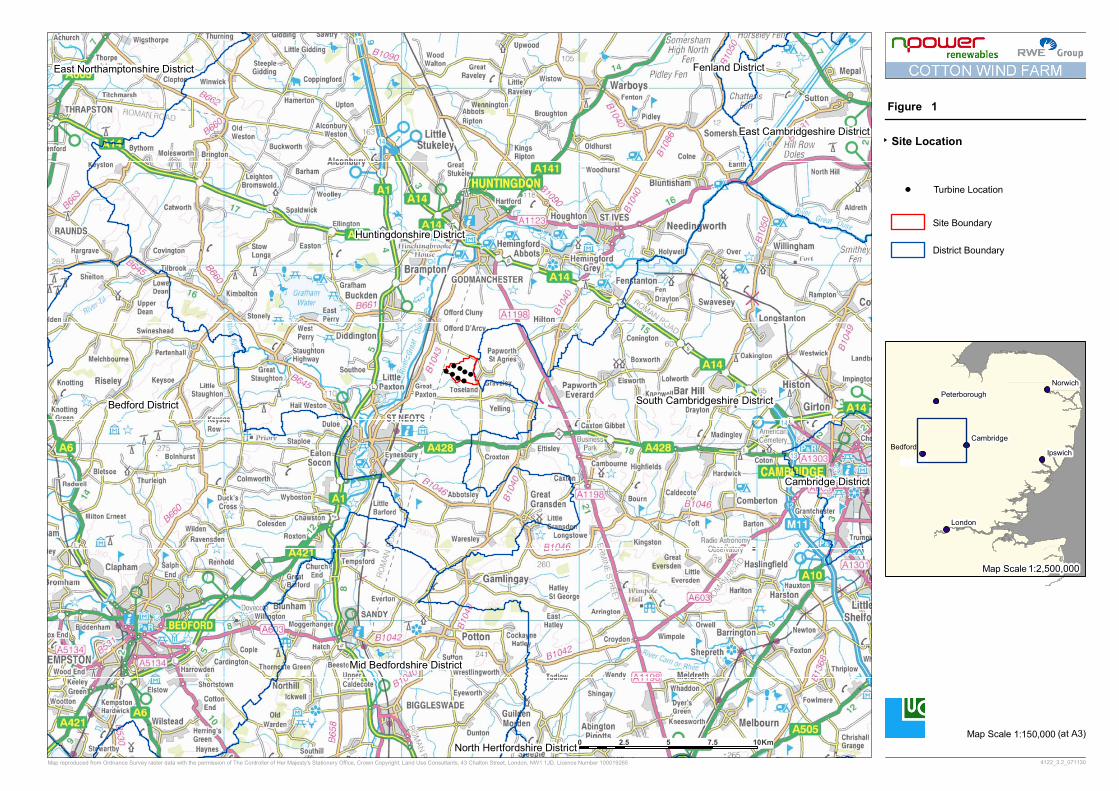
Cotton Wind Farm: Non Technical Summary i July 2008
This Non Technical Summary summarises the findings of an Environmental Statement for the proposed Cotton Wind Farm prepared by Land Use Consultants on behalf of npower
renewables Ltd.
The full Environmental Statement can be purchased, by writing to the address given below at a
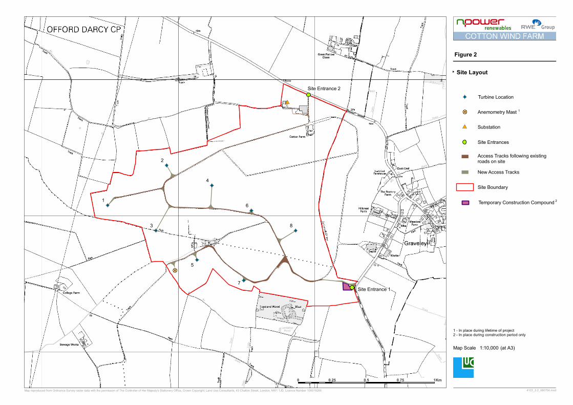
cost of £80 in hard copy format (including postage and packaging) or on CD-ROM (free) (including postage and packaging). Further copies of this Non Technical Summary are available
free of charge from the same address, and can also be downloaded from www.npower-
renewables.com/cottonfarm
Cotton Wind Farm
npower renewables Ltd. East of England Office
2nd Floor, 2 Kinsbourne Court 96-100 Luton Road
Harpenden, Hertfordshire AL5 3BL
Tel: 01582 641910
The Environmental Statement is also available for viewing during normal opening hours at: Huntingdonshire District Council
Pathfinder House
St Mary�s Street
Huntingdon
Cambridgeshire
PE29 3TN

Cotton Wind Farm: Non Technical Summary iii July 2008
NON TECHNICAL SUMMARY
CONTENTS
Introduction........................................................................................................................................... 1
Site Context and Scheme Description ............................................................................................ 1
Site Context....................................................................................................................................... 1
Scheme Description ......................................................................................................................... 2
EIA and the Design Process ........................................................................................................... 2
Construction Programme............................................................................................................... 3
Operation and Decommissioning ................................................................................................. 3
Rationale for Scheme........................................................................................................................... 3
Combating Climate Change ........................................................................................................... 3
Site Selection ......................................................................................................................................... 4
Planning Policy Context ...................................................................................................................... 5
Identifying the Environmental Issues ................................................................................................ 5 Key Environmental Impacts................................................................................................................ 6
Landscape and Visual Impacts ........................................................................................................ 6
Hydrology and Hydrogeology........................................................................................................ 9
Ecology .............................................................................................................................................. 10
Ornithology...................................................................................................................................... 11
Traffic and Transport..................................................................................................................... 12
Noise ................................................................................................................................................. 13
Arhcaeology and Cultural Heritage............................................................................................ 13
Aviation and Telecommunications.............................................................................................. 14
Social and Economic Impacts ....................................................................................................... 14
Shadow Flicker ................................................................................................................................ 15
Conclusion ....................................................................................................................................... 15
FIGURES Figure 1: Site Location
Figure 2: Site Layout

Cotton Wind Farm: Non Technical Summary 1 July 2008
NON TECHNICAL SUMMARY
INTRODUCTION
1. npower renewables Ltd. is proposing to build a wind farm known as Cotton Wind Farm on Cotton Farm in Huntingdonshire. This will involve construction of eight wind
turbines and associated infrastructure, including approximately 1.1km of new, additional access tracks.
2. The planning application will be determined by Huntingdonshire District Council under the Town and Country Planning Act 1990. As required by the Environmental Impact
Assessment (England and Wales) Regulations 1999, the planning application is accompanied
by an Environmental Statement (ES). This Non-Technical Summary summarises the
findings and conclusions of the ES in non-technical language.
3. The Environmental Impact Assessment (EIA) was carried out by Land Use Consultants (LUC) and specialist consultants on behalf of npower renewables Ltd (hereafter referred
to as NRL). NRL agreed the scope of the EIA with Huntingdonshire District Council
and a wide range of additional interested parties. The ES is based on the results of
studies of the potential environmental impacts, and includes a description of how the work was undertaken and any assumptions made during the assessment process. It sets
out the results of the assessment of likely impacts of the wind farm development on the environment, including mitigation measures to minimise any identified environmental
impacts.
SITE CONTEXT AND SCHEME DESCRIPTION
Site Context
4. The site is within Cotton Farm, situated approximately 1km west of Graveley, 2km
south east of Offord D�Arcy and 2km east of Great Paxton (see Figure 1). The site lies
within the district of Huntingdonshire, although the eastern boundary of the site is adjacent to South Cambridgeshire District. The closest village to the site, Graveley, lies
within South Cambridgeshire District. The total wind farm site occupies an area of approximately 179 hectares (or 1.79 square kilometres, equivalent to 442 acres).
5. The site, formerly an airfield in World War II and known as RAF Graveley up until 1968, is currently in private ownership and intensively farmed with arable crops. It is
extremely open and flat and there is an almost total absence of hedgerows except
around the farm boundary as a result of the site�s previous use as an airfield. The site lies at an elevation of 50m AOD and forms part of the plateau east of the Ouse Valley.
Many of the tracks laid during the site�s use as an airfield remain and are used for the existing farming activities. These tracks will be re-used wherever possible to form the
basis of the access tracks for the proposed wind farm.
6. There is one unnamed brook on the site itself, flowing out of the south west corner, in
addition to four small waterbodies located in a small area of woodland also in the south west of the site. Beyond the southern site boundary is Toseland Wood, which is home
to two ponds and a medieval moated Scheduled Ancient Monument. Lordship Pond lies
to the south of the wood. With the exception of a public footpath that runs
approximately along the southern boundary of the site from Toseland Road to Toseland Wood, there are no public rights of way within the site.
Cotton Wind Farm: Non Technical Summary 2 July 2008
7. Within the site boundary there is one dwelling (Cotton Farm) and a number of farm
buildings. A temporary 50m high anemometer mast to monitor wind speed was erected in Summer 2005 and removed in Spring 2008
Scheme Description
8. The main components of the scheme (see Figure 2) are:
• installation of eight wind turbines (each with a maximum height to blade tip of
127m);
• construction of approximately 1.1km of new onsite access tracks and the upgrading
of 4.6km of existing access track;
• construction of ancillary development comprising an onsite substation, crane hard-
standing areas, one external transformer adjacent to each turbine where required,
connecting cabling and one permanent wind monitoring mast;
• creation of a temporary construction compound close to site entrance and one
temporary wind monitoring mast which will be in place during the construction
period only;
• proposals for additional habitat management.
9. Access to the site during construction will be via two entrances: one via Toseland Road (Site Entrance 1) in the south east corner of the site; and one via the existing farm
entrance off Offord Road to the north (Site Entrance 2). With the exception of the materials required for the construction of the substation, all of the construction
materials including the turbine components (tower sections, blades, hubs, nacelle units), will be delivered to the site via Site Entrance 1. Only equipment and material required
for the construction of the substation will be brought to site via Site Entrance 2. The route for the majority of construction traffic will be via the A428(T) and along Toseland
Road (and Offord Road for the substation only), up to the proposed site entrances.
10. The proposed wind farm will be connected to the local distribution network, owned and operated by EDF, via an underground cable running from the onsite substation into one
of two existing 33kV lines which run approximately 1.5km north west and 1km north of the onsite substation. An application for connection to the grid has been lodged
separately with EDF, detailing both potential grid connection routes. A decision on the route to be used will be made in consultation with EDF; however, an initial assessment
of the two potential grid connection routes contained within the ES has found that grid
connection works could be undertaken without any significant environmental impacts.
EIA and the Design Process
11. Good practice advises that EIA should be treated as an iterative process, rather than a
one-off, post design environmental appraisal. In this way, the findings from the EIA can be fed into the design process, to avoid and minimise environmental impacts. This
approach was used for the Cotton Wind Farm EIA. Where potentially adverse environmental impacts were identified, the EIA was used to influence the scheme design
and formulate appropriate mitigation measures.
Cotton Wind Farm: Non Technical Summary 3 July 2008
Construction Programme
12. Subject to the granting of planning permission, construction is likely to be completed
over twelve months, depending on site-specific issues such as weather and ground conditions. The main phases of construction comprise:
• upgrading and widening of existing access tracks and construction of new access
track;
• construction of temporary construction compound;
• construction of turbine foundations, bases and hardstandings;
• construction of onsite substation;
• cable laying adjacent to site tracks;
• connection of distribution and signal cables;
• movement onto site and erection of wind turbines;
• commissioning of site equipment;
• site restoration.
13. It is estimated that the number of people that will be directly employed on the site during the 12-month construction period would range from between 10 and 30, with an
average of 20 persons employed on the site at any one time. Working hours are
proposed to be 8am to 6pm (Monday to Friday) and 8am to 1pm (on Saturday). Before
any construction work takes place, NRL will submit a construction method statement to Huntingdonshire District Council. This will contain more detailed information on the
design and construction of the main infrastructure components associated with the project.
Operation and Decommissioning
14. The wind farm has been designed with an operational life of 25 years. At the end of this period the turbines will be dismantled and removed from the site. It is estimated that the
decommissioning of the wind farm will be carried out over a period of approximately
two months.
15. No full time staff member will be required onsite during the operation of the proposed
wind farm as the site would be monitored remotely on a daily basis. However, some periodic maintenance and inspection checks will be required.
RATIONALE FOR SCHEME
Combating Climate Change
16. Global climate change is widely recognised as being one of the greatest environmental
challenges facing the world today. The UK Climate Impact Programme (UKCIP) has
predicted a range of possible climate change futures, reflecting assumptions about the
direction of socio-economic change and consequent amounts of greenhouse gases emitted.
Cotton Wind Farm: Non Technical Summary 4 July 2008
17. A scientific paper entitled �Extinction Risk from Climate Change� examined the effect of
climate change upon biodiversity. It estimated that up to 37% of all species of wildlife in the regions it studied could be faced with extinction due to climate change that is likely
to occur between now and 20501.
18. The Environment Agency predicts that the East of England climate is set to get warmer,
with wetter winters and drier summers compared with the present. It is suggested that by 2080 the climate in the East of England will be 3 to 5 degrees Celsius warmer than
current temperatures.
19. In February 2007, Huntingdonshire District Council committed to tackling climate
change, by signing the Nottingham Declaration on Climate Change and has become the
21st authority out of 54 in the East of England to do so. Signing of the declaration means that the Council has a commitment to develop plans with partners and local
communities to address the causes and impacts of climate change and to reduce emissions country-wide.
20. Reducing dependency on fossil fuels is a key element in tackling climate change and there is now a great deal of support from the UK Government for sustainable energy
solutions. The UK Government has made a commitment to reduce its carbon dioxide emissions by 20% (of 1990 levels), by 2010 and 60% by 2050. The Government has set a
target that 10% of the UK�s electricity requirements should be met via renewables by 2010 and this is being implemented via the Renewables Obligation2.
21. It is estimated that Cotton Wind Farm will meet the annual power needs of between
6,900 to 10,000 households - which is equivalent to approximately 11-16% of all the households within the district of Huntingdonshire.3
SITE SELECTION
22. NRL identify potential sites for wind farms by assessing areas of land against various
criteria, and this was the approach adopted in identifying the proposed site for Cotton Wind Farm. The criteria included predicted wind resource; proximity to dwellings;
electricity grid capacity; landscape and nature conservation factors such as presence of national designations; access; availability of land; and military or aviation interests. NRL
considered that the proposed Cotton Wind Farm was potentially acceptable when
considered against these criteria and on this basis NRL progressed the EIA work.
1 C.D. Thomas et al. (2004). Extinction Risk from Climate Change. Nature, Volume 427. 2 The Renewables Obligation obliges electricity suppliers to increase the proportion of electricity provided by
renewable sources to 10% by 2010, subject to the cost to consumers being acceptable. It is envisaged that the
Renewables Obligation will remain in place until 2026. 3 Based on an annual electricity consumption per home of 4700 kWh, which is derived from a total UK
domestic electricity consumption of 117.589 terawatt-hours (TWh), and 25.2 million UK households giving
4,666 kWh per year per household. UK energy consumption is as stated for 2004 in The Digest of UK Energy
Statistics (2005). The number of UK households is as stated for 2003 in the Mid-year Household Estimates
published in 2004 by the Office for National Statistics, with the number of households in Huntingdonshire
taken from the 2001 Census. The energy predicted to be generated by the proposal is derived from monitoring wind speeds in the area and
correlating this data to wind speeds measured at Met. Office stations. This enables a calculation to be made to estimate the average annual energy production for the site based on 8 turbines each of rated capacity of
between 2.0 and 3.0 MW. The energy capture and equivalent homes figure relating to this project may change
as more information is gathered.
Cotton Wind Farm: Non Technical Summary 5 July 2008
PLANNING POLICY CONTEXT
23. The proposed development lies within the District of Huntingdonshire and the adopted development plan comprises:
• The East of England Plan, the Revision to the Regional Spatial Strategy for the East of
England (May 2008).
• Cambridgeshire and Peterborough Structure Plan (2003) � saved policies.
• Huntingdonshire Local Plan (1995) � saved policies.
• Huntingdonshire Local Plan Alterations (2002) � saved policies.
24. The East of England Plan: The Revision to the Regional Spatial Strategy for the East of England (May 2008) contains policies specifically relating to wind energy developments. The East
of England Plan contains targets for the generation of electricity from renewable energy, with further, indicative targets for each county in the region. It also contains other
relevant policies on environmental matters.
25. There are also two adopted Supplementary Planning Documents (SPD) and Supplementary Planning Guidance (SPG) which are key material considerations for the
proposed wind farm:
• Huntingdonshire Landscape and Townscape Assessment SPD (2007).
• Huntingdonshire Wind Power SPD (2006).
• Cambridgeshire Landscape Guidelines Supplementary Planning Guidance (1993).
26. Whilst the SPDs and SPGs do not form part of the development plan, they can be used as material considerations in the determination of the application. The Huntingdonshire
Draft Core Strategy Preferred Options (2007) will also carry some weight in the
development control decision making process. Volume 1 sets out the draft policies and reasoned justification. Consultation on the Preferred Options took place from 30
November 2007 to 11 January 2008.
27. Given that the site lies adjacent to the district boundary between Huntingdonshire and
South Cambridgeshire it is also important to have regard for other relevant plans such as the South Cambridgeshire Core Strategy Development Plan Document (January 2007).
28. National planning guidance produced by Communities and Local Government (formerly
known as the Office of the Deputy Prime Minister (ODPM)), along with other
Government guidance, is also material to the planning decision.
IDENTIFYING THE ENVIRONMENTAL ISSUES
29. Consultation was an integral component throughout the EIA process, helping to set out
the range of environmental issues the EIA should address. It was also used to:
• obtain initial feedback on the proposal from statutory consultees and clarify the
scope of environmental work expected;
• collect baseline information and confirm survey methodologies;
• discuss opportunities for scheme modifications and additional mitigation and
enhancement measures where appropriate; and
Cotton Wind Farm: Non Technical Summary 6 July 2008
• inform the local public on the details of the proposed development, via newsletters and a public exhibition.
KEY ENVIRONMENTAL IMPACTS
Landscape and Visual
30. The landscape and visual impact assessment considered the impact that the wind farm
development will have upon the landscape and the people who view that landscape. The
assessment was informed by current good practice guidance prepared by the Landscape Institute and the Institute of Environmental Management and Assessment4, and
photomontages were prepared in accordance with Scottish Natural Heritage�s Visual Representation of Windfarms Good Practice Guidance5.
31. The assessment involved a desk study, field survey and computer modelling. The assessment methodology and choice of representative viewpoints for the assessment
were adopted in response to comments received from Huntingdonshire District Council, South Cambridgeshire District Council, Bedford Borough Council, East
Cambridgeshire District Council, and Fenland District Council. Photomontages and computer generated drawings were produced for 29 viewpoints around the site to
illustrate the likely nature of impacts. These are presented in the main Environmental
Statement.
32. The site is flat and open, situated on a plateau, and is an actively cultivated arable
landscape composed of large-scale arable fields. As a result of the establishment of the airfield in WWII there are no hedgerows within the site itself. However, there are some
more intact hedges beyond the site boundary. Toseland Wood, a semi-natural broad-
leaved woodland dominated by ash, is located just outside the southern boundary of the
site. Since there are relatively few individual landscape components on the site itself, it makes a limited positive contribution to the wider landscape. The absence of national
landscape designations indicates that this site is not valued at the national scale for its landscape quality or scenic beauty.
33. The Cotton Wind Farm site is located in the South East Claylands Landscape Character Area within Huntingdonshire District. Huntingdonshire District Council has undertaken
a landscape sensitivity and capacity assessment specifically in relation to commercial scale wind turbines which is set out in the Huntingdonshire Supplementary Planning
Document: Wind Power (February 2006). The SPD Wind Power document states that the South East Claylands landscape �generally has a low sensitivity to a single turbine or a
small scale turbine group, i.e. these developments could be accommodated without any adverse
effect on overall landscape character�. The big skies, distant horizons, and the presence of
existing man-made structures (such as industrial sheds, transport infrastructure and large
scale farm buildings) all contribute to the landscape�s ability to accommodate wind farms.
34. Although the topography of the landscape gives rise to a large zone of theoretical
visibility, layers of hedgerows, woodlands and built development substantially reduce actual visibility across the landscape at ground level. There are however, clear views of
the site from the edges of the closest villages (including Graveley, Toseland, Yelling, Great Paxton, and Offord D�Arcy).
4 Landscape Institute and the Institute of Environmental Management and Assessment (Second Edition 2002)
Guidelines for Landscape and Visual Impact Assessment. 5 Scottish Natural Heritage. (2006). Visual Representation of Windfarms Good Practice Guidance.
Cotton Wind Farm: Non Technical Summary 7 July 2008
35. To the south of the site, the well wooded nature of the Lower Greensand means views
are limited to those on the edge of the scarp and from here views are focussed north-west away from the site. Beyond it, the East Anglian Chalk Ridge provides elevated
views towards the site and the surrounding landscape from Royston. The flat expansive nature of the Fens allows potentially long-distance views from the north and east of the
study area. However, views are filtered by successive lines of vegetation. To the west
of the site the Yardley Whittlewood Ridge allows some views towards the site, while the
low-lying character of the Northamptonshire Vales beyond limits opportunities for views.
36. The proposed wind farm has been designed to minimise potential landscape and visual
impacts by ensuring that the turbines are seen as a coherent group from any viewpoint. In addition, a light grey colour and semi-matt finish are proposed to reduce the visibility
and reflectivity of the turbines. The substation building will be constructed in local brick to match the local building style.
Results of the Assessment of Landscape and Visual Impacts
37. The landscape and visual impact assessment concludes that the proposed wind farm will not result in any significant impacts on the landscape features of the site during
construction, operation or decommissioning.
38. In relation to landscape character, the assessment concludes that there will be a moderate (significant) impact on the character of parts of the Bedfordshire and
Cambridgeshire Claylands Countryside Character Area, the Western Claylands Landscape Character Area (Cambridgeshire Landscape Guidelines) and the South East Claylands
Landscape Character Area (Huntingdonshire Landscape and Townscape Assessment). However, this impact will decline with distance from the site and impact on these
character areas as a whole will not be significant.
39. The assessment also concludes that there will also be a moderate (significant) indirect
impact on the Ouse Valley Landscape Character Area (as identified in the Cambridgeshire Landscape Guidelines and Huntingdonshire Landscape and Townscape Assessment) as a
result of a change in views to and from the valley. However, the more sensitive features of the valley such as the river, flood plains and grazing meadows will not be affected by
the wind farm.
40. Significant impacts on views will all occur within 10km of the site, with the majority within 5km from the site. Within this area some properties will have a clear view of the
turbines, but many views would be obscured by vegetation or existing buildings. There are likely to be views of the turbines from nearby properties such as College Farm, and
from the edge of surrounding settlements, notably Graveley, Toseland, Yelling, Great Paxton, The Offords and Papworth. Generally, the impact on these views from
surrounding settlements is considered to be significant.
41. Walkers along the elevated dam at Grafham Water will see the turbines, however the
turbines will not be visible from the main car park areas, and north and south banks of
the reservoir. There will be glimpsed views of the turbines from the Ouse Valley Way
at Brampton Mill, from the Pathfinder Long Distance south of Godmanchester, from the A14 where it crosses the Ouse Valley, and from the A428 at Caxton Gibbet where the
roadside vegetation is less dense, but none of these changes will be significant.
42. Beyond 10km, the turbines would appear small and opportunities to view them will be
greatly limited by presence of landform, vegetation and built features in the landscape.
However, turbines will be seen from the Pathfinder Long Distance Footpath where it is
Cotton Wind Farm: Non Technical Summary 8 July 2008
elevated at Wyton Hill and the Three Shires Way footpath at the far western end of
Grafham Water where there are unobstructed views over open water. Turbines may also be glimpsed from parts of the Greensand Ridge Walk some 13km away, from parts
of the Three Shires Way long distance footpath 18km away, from the John Bunyan Trail 25km away, and from the chalk ridge at Therfield Heath 25km away. However, the
turbines will be extremely small and could go unnoticed in some views at these
distances.
43. There will be no views of the turbines from the major settlements of Cambridge, Peterborough, and Bedford.
44. It is unlikely that a proposal for a new wind farm in the UK would not result in some
significant impacts on views in the immediate locality. However, it should be acknowledged that impacts may be positive or negative. In the case of a wind farm,
whether impacts are perceived as positive or negative will depend in part on the sympathies of the viewer. Although the turbines are tall and would be clearly visible,
they are slender structures that would not obscure views across the landscape � a viewer would be able to see �through� the wind farm, between the turbines.
45. An assessment of potential cumulative impacts arising from the Cotton Wind Farm in combination with the existing turbines at Wood Green, Red Tile and Glass Moor; and
the proposed turbines at St Mary�s Road Ramsey, Airfield Farm, and Rockery Farm was informed by Scottish Natural Heritage�s guidance on the �Cumulative Effect of Wind
Farms�6. The wind farm developments considered in the cumulative assessment occur in
three distinct clusters, and the separation this affords means the landscape character
areas are not dominated by wind energy developments, and the fundamental character of the landscapes, or the differences between landscape types, will not be changed. All
the wind farms are over 20km from the Cotton Farm site, except for Wood Green (4km away) and Rockery Farm (11km away), and the assessment concluded that there
will be no significant cumulative impacts on landscape character or designated
landscapes.
46. In terms of cumulative visual impacts, there are few places from which more than one
wind farm will be visible at the same time, due to the distance between developments and the presence of vegetation at ground level in a relatively flat landscape. Cumulative
visual impact was assessed from 29 viewpoints (360 degree views were considered) and 12 key local routes (roads, footpaths and cycle routes). The assessment concluded that
there will be significant cumulative effects on two of the viewpoints: at Hemingford Grey, from where the Wood Green turbine and Cotton Wind Farm turbines will both
be visible, and at Wyton Hill, from where the Wood Green turbine and all eight of the Cotton Wind Farm turbines will be visible on the skyline.
47. The assessment also concluded that there will be a significant cumulative impact on
sequential views from one of the 12 routes considered across the study area. Route 6,
the Pathfinder Long Distance Walk, will experience cumulative effects of moderate significance due to several wind farms theoretically being visible from this footpath, with
Cotton Wind Farm the most likely to affect views (800m away at its closest point).
6 Scottish Natural Heritage. (2005). Cumulative Effect of Wind Farms.
Cotton Wind Farm: Non Technical Summary 9 July 2008
Hydrology and Hydrogeology
48. This assessment considered whether the construction, operation and decommissioning of the wind farm could have an impact on existing site conditions including surface
water, groundwater and flooding.
49. The proposed development site is in the catchment of the River Great Ouse, and is
divided into four subcatchments: two drain to the River Great Ouse north of St Neots and two drain to the River Great Ouse east of St Ives. There are a number of field
ditches and small brooks that drain the land in the vicinity of the site. There is one unnamed brook on the site itself, flowing out of the south west corner of the site. The
existing land use at the proposed development site is arable farmland, which allows infiltration and slows surface water runoff, although the concrete and tarmac access
tracks are impermeable and water runs off into the surrounding fields.
50. The geology in and around the proposed Cotton Wind Farm comprises Boulder Clay
overlying Oxford Clay, neither of which are aquifers and therefore do not contain
significant groundwater. Huntingdonshire District Council and South Cambridgeshire District Council confirmed that there are no private water supplies within the local
vicinity of the site, and the Environment Agency has confirmed that there are no groundwater or surface water abstraction licenses.
51. The entire site is in Flood Zone 1 (a low probability of flooding). However, as the site area is greater than 1ha, a Flood Risk Assessment for the proposed wind farm has been
carried out. The Flood Risk Assessment confirmed that the site is within Flood Zone 1, and that the site is not at risk from sewer flooding, groundwater flooding or flooding
from an artificial source. The Flood Risk Assessment also identified the need for artificial drainage due to the increase in hard surface areas (e.g. new access tracks), which can
prevent water from soaking into the ground. The Huntingdonshire Strategic Flood Risk Assessment (2004) also demonstrates that the site is in Flood Zone 1 when considering
climate change up to the year 2054. The sensitivity of the site to flooding was therefore determined to be low.
52. Excavated or stockpiled material during construction of the proposed development
could be washed into local watercourses or drains, resulting in blockages and therefore an increased flood risk. However, prevention of stockpiled and excavated materials
from washing into watercourses and drains would reduce the likelihood of this occurring, so the proposed development is unlikely to result in a significant impact on
local watercourses, drains and flood risk. Similarly, controlled working practices reduce the likelihood of the accidental pollution of surface water bodies and groundwater. As
such, there is unlikely to be a significant impact on surface water bodies and groundwater as a result of any accidental pollution from the development.
53. The probability of surface water runoff increasing due to the development is likely due to the increase in the impermeable surface area at the site. In accordance with national
guidance and following consultation with the Environment Agency, soakaways will be
built into the scheme to reduce surface water runoff and volume. These measures mean that there is unlikely to be any significant impact on the surface water runoff rates and
volumes within the site as a result of the proposed development.
54. There is no significant groundwater at the site due to the hydrogeology of the soil
therefore it is unlikely that ground excavations will affect groundwater.
Cotton Wind Farm: Non Technical Summary 10 July 2008
Ecology
55. The assessment of the impacts on ecology was undertaken, based on advice received from Natural England, the Environment Agency, the RSPB and the Wildlife Trust for
Bedfordshire, Cambridgeshire, Northamptonshire and Peterborough. An extended
Phase 1 Habitat Survey was completed, supplemented by more detailed surveys of rare
and scarce plants, bats, badger, brown hare and great crested newt. These surveys, coupled with existing biological records, were used to assess the impacts of the wind
farm on ecology.
56. There are no designated sites within the site. The nearest statutory site is Little Paxton
Pits Site of Special Scientific Interest (SSSI) situated approximately 2km to the west. Three non-statutory sites, all of which are County Wildlife Sites, lie within 2km of the
site at Toseland Churchyard, Bankside Nature Reserve and parts of the River Great Ouse. No adverse impact on any of these sites is predicted.
57. The site is primarily arable farmland, although 5% of the survey area included other
habitat types, such as semi-natural broad-leaved woodland (Toseland Wood bordering the southern site boundary and a remnant spinney within the site), plantation woodland
(surrounding the farm buildings), scrub semi-improved grassland (as verges) and improved grassland (sheep grazed paddocks). These habitats do provide variation in the
arable landscape but are limited in extent and are all abundant in the wider area. The value and extent of hedgerows across the survey area was relatively limited and
assessment in respect of the Hedgerow Regulations was not deemed appropriate.
However, those present do have some value in terms of connectivity and this has been
taken into account when assessing the site in respect of protected species. No rare or scarce species of arable weed were recorded on the site - species present were all
common and typical of the habitats surveyed. Waterbodies present were not of notable value in themselves but both the static ponds and streams were considered in respect of
protected species. No significant impacts on the habitats present within or immediately surrounding the site are predicted.
58. The wind farm will not result in the direct loss of any bat roost. Foraging and
commuting opportunities are associated with the hedgerows and wooded habitats at the fringes of the site, which support low levels of bat activity. Activity is also very low in
the open arable areas at the centre of the site. No bat dispersal corridors will be severed for temporary access or permanent landtake and turbines have been located as
far as practicable from features supporting bat activity.
59. The lack of evidence of badger activity, including foraging, across the site means that no
detrimental impacts are predicted.
60. Brown hare were distributed throughout the site, particularly in open arable habitat.
Statistical analysis suggests a brown hare density at Cotton Farm that exceeds the national average (1996 UK National Brown Hare Survey) and is therefore considered to
form a high population density. Impacts during construction are likely to be limited,
primarily associated with disturbance during the construction phase.
61. The suite of amphibian surveys identified a small population of great crested newt in a
single pond within the spinney. Associated terrestrial habitats suitable for great crested newt include a relatively limited extent of associated ditches and hedgerows. Potential
impacts relate to the low risk of killing and/or injury during movement of construction vehicles on tracks in the vicinity of the pond, and to indirect accidental pollution and/or
siltation of the pond itself.
Cotton Wind Farm: Non Technical Summary 11 July 2008
62. Should the wind farm be granted permission, the detailed positioning of turbines will
take full account of ecological issues. Construction will follow best practice, for example to minimise encroachment into retained habitats, to minimise impacts associated with
lighting and to avoid pollution and/or siltation of waterbodies. A site-wide speed limit on vehicles during construction and operation will be enforced, to minimise the risk of
collision with species such as hare. It will also be possible to minimise the risk of
vehicles killing great crested newt by managing their habitat to discourage newts near to
the access roads.
63. It is also intended that enhancement measures will be implemented in line with relevant
Environmental Stewardship policies of the Rural Development Service, such as the provision of buffer strips, beetle banks and sown floristically enhanced margins. These
measures seek to provide greater diversity of habitat structure throughout the year, particularly following harvest. Habitat will be provided both in linear form as wildlife
corridors, complementing existing features, and as islands to provide habitat amongst the crop monoculture.
64. Taking into account proposed mitigation, no significant ecological impacts are predicted
during construction. During operation, impacts of minor negative significance remain for bats, with minor beneficial impacts predicted for brown hare resulting from the creation
of additional habitat.
Ornithology
65. The ornithological assessment was based on a combination of desk and field surveys,
with the latter comprising specific surveys for breeding and wintering birds (including
vantage point surveys) and flight activity across the site. Natural England, the Environment Agency, the Royal Society for the Protection of Birds (RSPB) and the
Wildlife Trust for Bedfordshire, Cambridgeshire, Northamptonshire and Peterborough
were consulted to identify relevant data and agree survey methodologies.
66. There are no sites designated under Natura 2000 as Special Protection Ares (SPA)
within 10km of the site. Portholme Special Area of Conservation (SAC) is some 5.2km to the north although this is not designated for its bird interest. Little Paxton Pits Site of
Special Scientific Interest (SSSI) is of national importance for wintering wildfowl and an important stopping point for migrant species, and Grafham Water SSSI is considered one
of the most important sites for migrants and wintering species in the region.
67. A total of 49 species of breeding bird were recorded during the surveys, of which 38
were recorded holding territory or displaying signs of breeding. The remaining 11 species that were observed did not display any evidence of breeding within the survey
area. Many of the birds recorded are important because they are nationally rare or have experienced substantial declines in their populations and their protection is accorded a
high priority. Notable examples include common quail, barn owl and skylark.
68. Some 50 species of bird were recorded during the winter walkover surveys, including several hundred lapwing and golden plover feeding and roosting in open parts of the site,
and 13 target species were recorded during the vantage point surveys.
69. It is considered that wildfowl using the Little Paxton Pits and Grafham Water SSSIs
would not be disturbed by the wind farm due to the limited number of recorded flights at the site of species for which the areas are designated.
Cotton Wind Farm: Non Technical Summary 12 July 2008
70. With regard to individual species, particular attention was paid to peregrine, hobby and
kite due to their conservation importance. It is considered that there will be no significant impact on these species because they are not prevalent at the site, nor were
they found to be breeding within 2km of the proposed turbines. The impacts on breeding quail, wintering golden plover, lapwing, breeding and hunting barn owls, and
breeding and wintering farmland birds were also considered in detail.
71. While the wind farm is being built (and decommissioned) birds could be affected by
noise and the presence of the construction workforce, leading to disruption of breeding and foraging. However all of these impacts were not judged to be significant. Where
minor impacts are predicted, vegetation clearance will be undertaken outside the breeding season (usually March to August) to limit breeding in proximity to the
construction areas. If necessary, appropriate mitigation to protect barn owls from disturbance will also be agreed in advance of construction work taking place.
72. Once the wind farm is operational, individual turbines may present a barrier to the
movement of birds, which may in turn affect populations across a wider area. However studies have shown that in general, species are not disturbed beyond 600 � 800m from
turbines, and in some cases birds have not been disturbed at all. There is also the risk of birds colliding with turbines which is almost certain to result in death of the bird. The
assessment has demonstrated that the impact on bird movement and the risk of collisions is low, and the impacts are therefore minor.
Traffic and Transport
73. The key objective of the traffic and transport assessment was to assess the
environmental impacts that are potentially significant where the proposed wind farm is likely to give rise to changes in traffic flows. Potentially significant environmental impacts
are likely to derive from the movement commercial HGVs and other specialist equipment and vehicles (including abnormal loads) travelling to and from the site during
construction.
74. Abnormal loads will access the site from the Port of Felixstowe, travelling westbound along the A428 and then heading north along Toseland Road, Croxton Road, and
Graveley Road until they reach site entrance 1 in the south east corner of the site. With the exception of the materials required for the construction of the substation, all
of the construction traffic will use Site Entrance 1 during the construction phase. During the operational phase, NRL�s Operations team, who are likely to visit the site in a light
van up to twice a week, will use site entrance 2 in the north eastern corner of the site. Any vehicle larger than a light van will use Site Entrance 1 during the operational period
to allow access for cranes etc. that may be required for maintenance purposes.
75. The maximum traffic impact associated with the construction of the proposed wind farm
is predicted to occur in the third month of the construction programme. During this month, an average of 42 two-way trips (excluding concrete for turbine bases) and 118
two-way trips (delivering concrete for turbine bases only which will occur on a total of 8
days) are predicted to be generated during each working day.
76. The maximum potential increases in HGV traffic generated during construction (on days
with no concrete delivery for turbine bases) for the A428 east of Toseland Road, the A428 west of Toseland Road, and Toseland Road itself are 2.2%, 2.3% and 41.6%
respectively. For days when deliveries of concrete for the turbine bases occur, these figures increase to 6.1% (A428 east of Toseland Road), 6.4% (A428 west of Toseland
Road), and 116.8% (Toseland Road). The predicted increases in traffic on Toseland
Cotton Wind Farm: Non Technical Summary 13 July 2008
Road, as a result of traffic generated during construction, exceeds recommended
thresholds and, therefore, a assessment of the potentially significant environmental impacts on Toseland Road was conducted.
77. This assessment considered the potentially significant environmental impacts of
severance, driver delay, pedestrian delay, pedestrian amenity, fear and intimidation, and
accidents and safety. These impacts were judged to be not significant on Toseland Road. However, mitigation measures have been proposed in order to control environmental
impacts that could occur and that could be significant during construction. Such measures include vehicle wheel and body washing facilities to ensure debris and mud is
not carried onto the highway.
Noise
78. An assessment was made of the potential noise impact from the proposed Cotton Wind
Farm on the residents of nearby dwellings during construction, operation and
decommissioning. The noise impact assessment was undertaken in line with
Government guidance on assessing construction noise generally and noise from wind turbines in particular. Measurements of existing background noise levels were made at 4
residential locations around the site.
79. The operational noise assessment was carried out by comparing predicted operational
noise levels (based on manufacturer information about the type of turbine that could be installed at Cotton Wind Farm) with the existing background noise levels. Calculated
construction noise levels were compared with the existing background noise in the vicinity of the wind farm site and also with absolute noise limits for temporary
construction activities that are normally used to gauge the acceptability of construction noise.
80. Results of the construction noise assessment show that the predicted noise levels,
including for onsite activity and construction traffic on public roads, should be below the lowest absolute limits, and is therefore not expected to be significant. Notwithstanding
this, best practicable means will be used to reduce noise levels. As such it is proposed that site working hours will be limited to 08:00 to 18:00 Monday to Friday and 08:00 to
13:00 on Saturdays.
81. The predicted levels of noise during the operational and decommissioning phases are in
accordance with Government guidance, and deemed to be acceptable.
Archaeology and Cultural Heritage
82. The archaeology and cultural heritage assessment evaluated the impacts of the proposed
Cotton Wind Farm on archaeological features, historic landscape character, and built heritage including registered parks and gardens.
83. The significance of potential impacts was assessed by taking into account the sensitivity of archaeological and heritage features and the extent to which they would be affected,
by construction activities and the operation of the wind farm. Sensitivity of the archaeological and heritage resources is dependent on factors such as the condition and
heritage value of the site. Impact magnitude is a function of the nature, scale and type of disturbance, or damage, to the archaeological or heritage resource.
84. Information on archaeology, historic buildings and other cultural assets was gathered
from the National Monuments Record, from the Cambridgeshire Historic Environment
Record, Cambridgeshire Records Office and Huntingdonshire Records Office.
Cotton Wind Farm: Non Technical Summary 14 July 2008
85. Following evaluation of the site and the specific turbine locations it is considered that
there will be no significant impacts upon archaeological remains and the setting of listed buildings, conservation areas and registered parks and gardens during construction and
operation of the wind farm.
Aviation and Telecommunications
86. Wind farms potentially can affect civilian and military airspace and radar, telecommunications links (including mobile phone links and fixed microwave links), and
radio and television reception. Information on existing aviation and telecommunications links was obtained through consultation with Ofcom, the Civil Aviation Authority,
Ministry of Defence, Cambridge Airport, mobile phone operators, the BBC and the Joint Radio Company.
87. Interference with communications links is highly location dependent and the relocation
of turbines by just a few metres can usually resolve any problems. Due to the distances
between the turbines proposed at Cotton Wind Farm and the scope to adjust their
positions, existing communication links are unlikely to be affected.
88. It is considered that the wind farm would not affect TV reception in the local area.
However NRL will carry out a survey of reception prior to construction of the wind farm. Should interference to TV reception occur as a result of the operation of the
wind farm, NRL will implement the necessary remedial measures. These might include providing improved receiving aerials, realigning existing aerials or re-tuning to receive
transmissions from an alternative TV transmitter. Alternatively, another source of suitable television signals could be provided. Digital television signals are generally more
robust and therefore less likely to be subject to interference effects from a wind farm.
89. Safeguarded airports are normally consulted on any development proposals within their consultation zones. There is a 15km consultation zone and a 30km or 32km advisory
zone around every civilian and military air traffic radar respectively. Nine aviation facilities in the vicinity of the proposed site were identified and discussions have taken
place with the Ministry of Defence. However Cotton Farm is located far enough from these sites for impacts on air traffic services and radars to be insignificant.
Social and Economic Impacts
90. The assessment of social and economic impacts of the wind farm concentrated on four
topics: recreation and public access, employment, farm diversification and tourism.
Recreation and Public Access
91. While no public rights of way cross the site, there are several public footpaths and
bridleways in the vicinity. None of these will be affected by the construction or
operation of the wind farm.
92. Part of the south east corner of the site is used by a model aircraft club for flying. It is
likely that the club may have to temporarily suspend activities while the wind farm is being built.
93. Concern is sometimes expressed by members of the public with regard to horses and horse-riding near to wind farms. The British Horse Society (BHS) recommends a
separation of 200 metres between operational turbines and bridleways. This recommendation has been incorporated into the design of the scheme.
Cotton Wind Farm: Non Technical Summary 15 July 2008
Employment
94. A potential benefit of a project of this sort is local employment and economic activity
during the construction phase, where local businesses are often best placed to secure
contracts. During the construction phase it is likely that the equivalent of around 1.0-1.5 full time workers7 would be employed. Goods and services, including construction
materials, labour, transport and plant hire would be used during the construction phase,
providing the potential for indirect employment and expenditure in the area. Similarly, there would be some additional employment arising from the need to maintain turbines
while they are in operation.
Farm Diversification
95. The wind farm will provide an opportunity for diversification of the farming activities
already taking place on site. Also, while some land would be lost due to the presence of
the individual turbines, this will not affect the overall viability of farming activities.
Tourism
96. There are no direct impacts on tourism predicted as a result of the wind farm, although
it is possible that the wind farm could become a feature of interest in the local area.
Shadow Flicker
97. Shadow flicker is the name given to the shadow cast over properties when the sun
passes behind the rotor of a turbine. It only occurs inside buildings where the flicker appears through a narrow window. The further a property is from the turbine, the less
pronounced any shadow flicker will be. This is because there are fewer times when the sun is low enough to cast a long enough shadow; because there is a higher likelihood of
the sun being obscured by either cloud on the horizon or intervening land, buildings and vegetation; or because, at distance, the blades do not cover the sun but only partly mask
it, substantially weakening the shadow. Also, the extent of shadow flicker effects is in
practice limited to a distance of 10 rotor diameters from the wind farm. For the Cotton
Wind Farm this corresponds to a distance of 900m from each turbine.
98. In the event that any local residents within 10 rotor diameters of the wind farm find impacts of shadow flicker to be of annoyance once the turbines are operational, NRL
will work with them in order to establish the most effective mitigation. Possible
solutions can include providing blinds for the windows of rooms affected, or providing
planting or landscaping in gardens at the properties concerned. It can be possible to switch off wind turbines during periods where shadow flicker can occur, taking into
account the weather conditions present.
CONCLUSION
99. The EIA of the proposed Cotton Wind Farm was carried out in accordance with
regulatory requirements and guidance on good practice. The ES shows that, with the
proposed mitigation measures in place, many potential environmental impacts associated
with the construction and operation of the wind farm can be avoided or minimised.
100. The ES concludes that significant impacts will only occur in relation to the visual impact
of the development during construction and operation. However, the assessment
reveals that the majority of representative viewpoints predicted to experience significant
impacts are located within 5km of the nearest turbine. Within this area some properties
7 This is full time equivalent � approximately 10-15 people are expected to be employed in total.
Cotton Wind Farm: Non Technical Summary 16 July 2008
will have a clear view of the turbines but many would be screened by vegetation or
existing buildings.
101. The cumulative landscape and visual assessment revealed that there will be significant
cumulative effects on two of the viewpoints: at Hemingford Grey, from where the
Wood Green turbine and Cotton Wind Farm turbines will both be visible, and at Wyton
Hill, from where the Wood Green turbine and all eight of the Cotton Wind Farm turbines will be visible on the skyline.
102. No other significant impacts in relation to hydrology, noise, ecology, traffic and
transport, archaeology, aviation and telecommunications, shadow flicker, the economy
and public access are predicted to occur.
Huntingdonshire District
Bedford District South Cambridgeshire District
East Northamptonshire District
Mid Bedfordshire District
East Cambridgeshire District
Cambridge District
Fenland District
North Hertfordshire District
Map reproduced from Ordnance Survey raster data with the permission of The Controller of Her Majesty's Stationery Office, Crown Copyright. Land Use Consultants, 43 Chalton Street, London, NW1 1JD. Licence Number 100019265
Figure 1
Site Location
0 2.5 5 7.5 10Km
4122_3.2_071130
Turbine Location
London
Ipswich
Norwich
Cambridge
Peterborough
Bedford
Map Scale 1:150,000 (at A3)
1:2,500,000Map Scale
Site Boundary
District Boundary

Site Entrance 1
Site Entrance 2
8
7
6
5
4
3
2
1
Map Scale
Map reproduced from Ordnance Survey raster data with the permission of The Controller of Her Majesty's Stationery Office, Crown Copyright. Land Use Consultants, 43 Chalton Street, London, NW1 1JD. Licence Number 100019265
Figure 2
Site Layout
0 0.25 0.5 0.75 1Km
4122_3.2_080704.mxd
Anemometry Mast
Substation
Turbine Location
Temporary Construction Compound
Site Boundary
Access Tracks following existing roads on site
New Access Tracks
1:10,000 (at A3)
Site Entrances
1
2
1 - In place during lifetime of project2 - In place during construction period only


npower renewables - East of England Office
2nd Floor
2 Kinsbourne Court
96-100 Luton Road
Harpenden
Hertfordshire
AL5 3BL
Tel: 01582 641910
www.npower-renewables.com
Land Use Consultants - Bristol Office
14 Great George Street
Bristol
BS1 5RH
www.landuse.co.uk
printed on recycled paper