Embed Size (px)
Citation preview
Facts
The Costa Concordia was
> the largest Italian cruise ship ever conceived
> carrying 2380 tons of fuel on board, which was removed in March 2012
> transporting more than 4200 passengers and crew.
Benefits
> Monitoring of recovery operations day and night and in all weather conditions over a long period with radar satellite imagery
> Up-to-date information to better plan risk mitigation and immediate response in case of an oil spill
Policy Objectives
> European Maritime Transport Policy Until 2018
> Marine Strategy Framework Directive
> MARPOL Convention
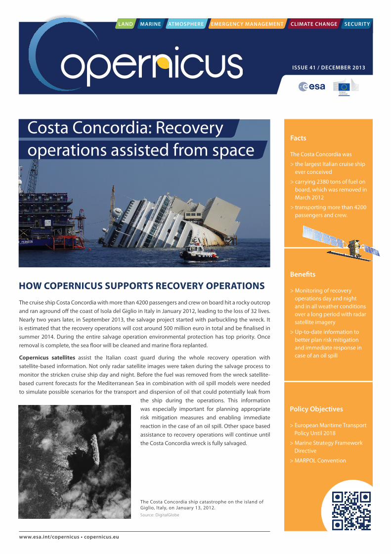
The Costa Concordia ship catastrophe on the island of Giglio, Italy, on January 13, 2012. Source: DigitalGlobe
HOW COPERNICUS SUPPORTS RECOVERY OPERATIONS
www.esa.int/copernicus • copernicus.eu
The cruise ship Costa Concordia with more than 4200 passengers and crew on board hit a rocky outcrop and ran aground off the coast of Isola del Giglio in Italy in January 2012, leading to the loss of 32 lives. Nearly two years later, in September 2013, the salvage project started with parbuckling the wreck. It is estimated that the recovery operations will cost around 500 million euro in total and be finalised in summer 2014. During the entire salvage operation environmental protection has top priority. Once removal is complete, the sea floor will be cleaned and marine flora replanted.
Copernicus satellites assist the Italian coast guard during the whole recovery operation with satellite-based information. Not only radar satellite images were taken during the salvage process to monitor the stricken cruise ship day and night. Before the fuel was removed from the wreck satellite-based current forecasts for the Mediterranean Sea in combination with oil spill models were needed to simulate possible scenarios for the transport and dispersion of oil that could potentially leak from
the ship during the operations. This information was especially important for planning appropriate risk mitigation measures and enabling immediate reaction in the case of an oil spill. Other space based assistance to recovery operations will continue until the Costa Concordia wreck is fully salvaged.
Costa Concordia: Recovery operations assisted from space
LAND MARINE ATMOSPHERE EMERGENCY MANAGEMENT CLIMATE CHANGE SECURITY
ISSUE 41 / DECEMBER 2013
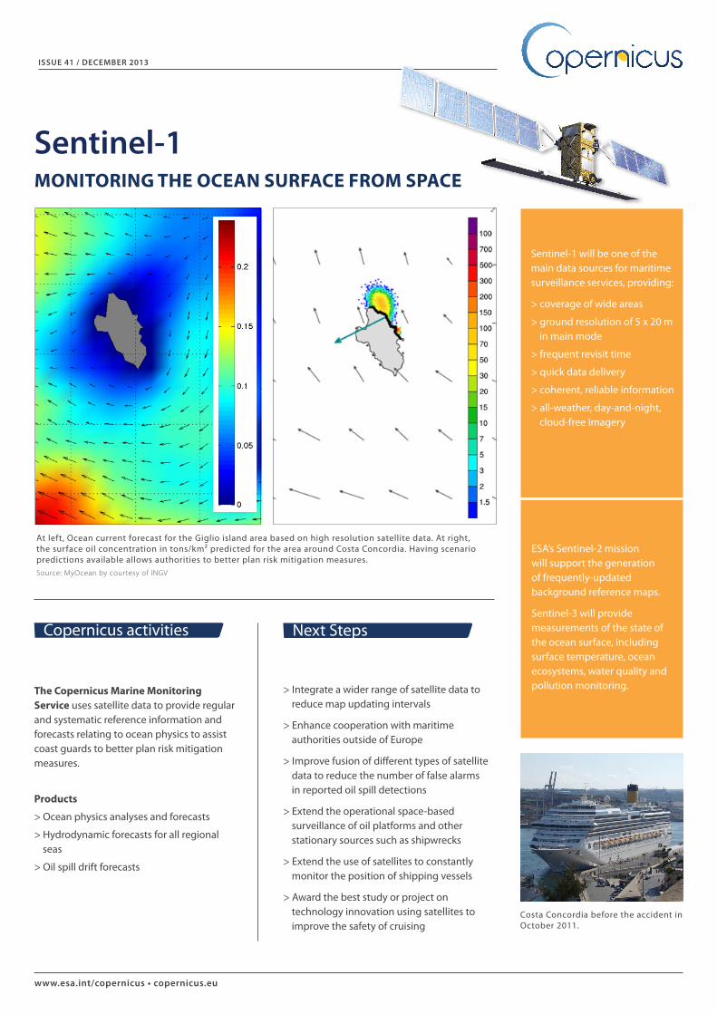
At left, Ocean current forecast for the Giglio island area based on high resolution satellite data. At right, the surface oil concentration in tons/km² predicted for the area around Costa Concordia. Having scenario predictions available allows authorities to better plan risk mitigation measures. Source: MyOcean by courtesy of INGV
www.esa.int/copernicus • copernicus.eu
> Integrate a wider range of satellite data to reduce map updating intervals
> Enhance cooperation with maritime authorities outside of Europe
> Improve fusion of different types of satellite data to reduce the number of false alarms in reported oil spill detections
> Extend the operational space-based surveillance of oil platforms and other stationary sources such as shipwrecks
> Extend the use of satellites to constantly monitor the position of shipping vessels
> Award the best study or project on technology innovation using satellites to improve the safety of cruising
The Copernicus Marine Monitoring Service uses satellite data to provide regular and systematic reference information and forecasts relating to ocean physics to assist coast guards to better plan risk mitigation measures.
Products
> Ocean physics analyses and forecasts
> Hydrodynamic forecasts for all regional seas
> Oil spill drift forecasts
Copernicus activities Next Steps
Sentinel-1 will be one of the main data sources for maritime surveillance services, providing:
> coverage of wide areas
> ground resolution of 5 x 20 m in main mode
> frequent revisit time
> quick data delivery
> coherent, reliable information
> all-weather, day-and-night, cloud-free imagery
ISSUE 41 / DECEMBER 2013
Sentinel-1MONITORING THE OCEAN SURFACE FROM SPACE
ESA’s Sentinel-2 mission will support the generation of frequently-updated background reference maps.
Sentinel-3 will provide measurements of the state of the ocean surface, including surface temperature, ocean ecosystems, water quality and pollution monitoring.
Costa Concordia before the accident in October 2011.