Embed Size (px)
Citation preview
COSPAS-SARSAT PRESENTATIONSystem protection issues examined through agenda item 9.1.1
Dany St-Pierre, Principal Technical officer Cospas-Sarsat secretariat,
Montreal, CanadaJean PLA, spectrum management,
Centre National d’Etudes Spatiales, Toulouse, France
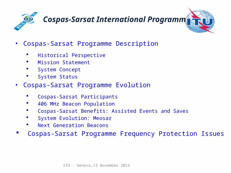
Cospas-Sarsat International Programme
• Cospas-Sarsat Programme Description
Historical Perspective Mission Statement System Concept System Status
• Cospas-Sarsat Programme Evolution
Cospas-Sarsat Participants 406 MHz Beacon Population Cospas-Sarsat Benefits: Assisted Events and Saves System Evolution: Meosar Next Generation Beacons
Cospas-Sarsat Programme Frequency Protection Issues
ITU - Geneva,13 November 2014
ITU - Geneva,13 November 2014
Cospas-Sarsat Programme: Historical Perspective
• 1978: Canada, France and the USA agree to co-operate on the development of the SARSAT low-altitude polar orbiting system to:
• Locate existing 121.5 MHz beacons
• Develop new 406 MHz technology for improved performance
• During the same period the USSR was also considering a satellite concept aimed at detecting and locating ships in distress worldwide also using the 406 MHz band, the COSPAS project
• The four countries declared their interest in co-operating and ensuring the inter-operability of their systems in an MOU signed in 1979
• The International Cospas-Sarsat Programme Agreement (ICSPA) was signed on July 1, 1988 among the governments of Canada, France, the former U.S.S.R and the United States. The ICSPA ensured continuity of the space system and availability to all States on a non-discriminatory basis
• 406 MHz beacons accepted by IMO for GMDSS in 1988
ITU - Geneva,13 November 2014
Cospas-Sarsat Programme: Mission, Objective and Strategy
Mission Statement
The International Cospas-Sarsat Programme provides accurate, timely and reliable distress alert and location data to help search and rescue authorities assist persons in distress.
Objective
The objective of the Cospas-Sarsat system is to reduce, as far as possible, delays in the provision of distress alerts to SAR services, and the time required to locate a distress and provide assistance, which have a direct impact on the probability of survival of the person in distress at sea or on land.
StrategyCospas-Sarsat Participants implement, maintain, co-ordinate and operate a satellite system capable of detecting distress alert transmission from radiobeacons and of determining their position anywhere on the globe. The distress alert and location data is provided by Cospas-Sarsat Participants to the responsible SAR services.
Services are provided world-wide and free of charge for the user in distress.
ITU - Geneva,13 November 2014
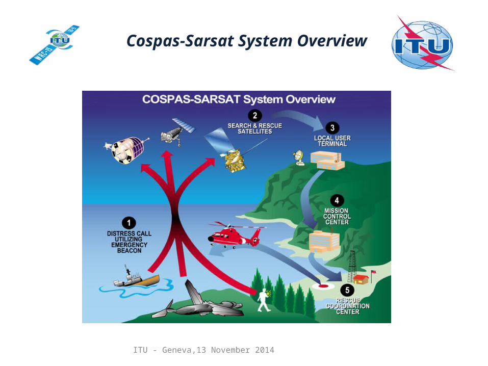
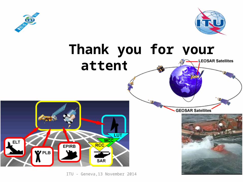
Cospas-Sarsat System Overview
ITU - Geneva,13 November 2014
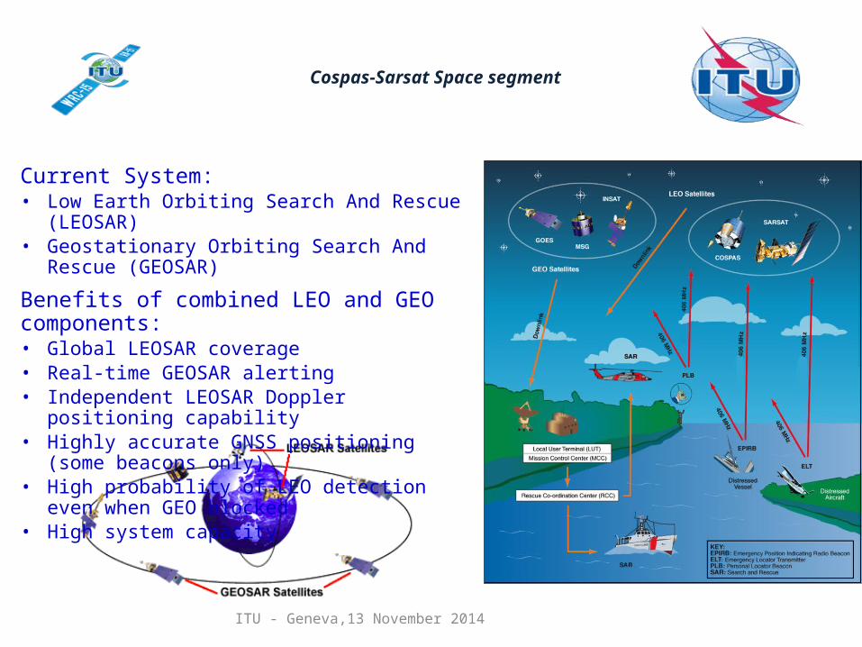
Cospas-Sarsat Space segment
Current System:• Low Earth Orbiting Search And Rescue (LEOSAR)• Geostationary Orbiting Search And Rescue (GEOSAR)
Benefits of combined LEO and GEO components:• Global LEOSAR coverage• Real-time GEOSAR alerting• Independent LEOSAR Doppler positioning capability• Highly accurate GNSS positioning (some beacons only)• High probability of LEO detection even when GEO
blocked• High system capacity
ITU - Geneva,13 November 2014
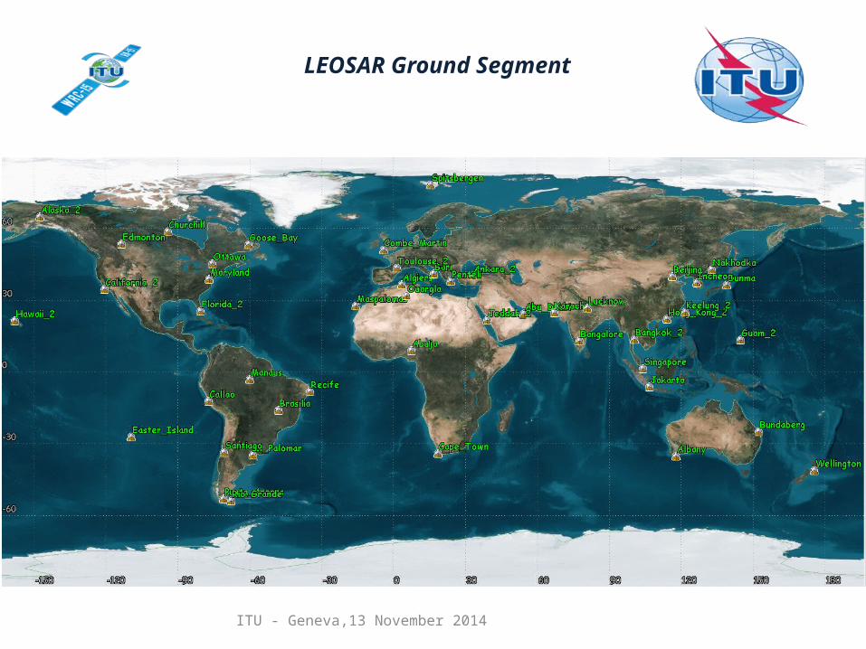
LEOSAR Ground Segment
ITU - Geneva,13 November 2014
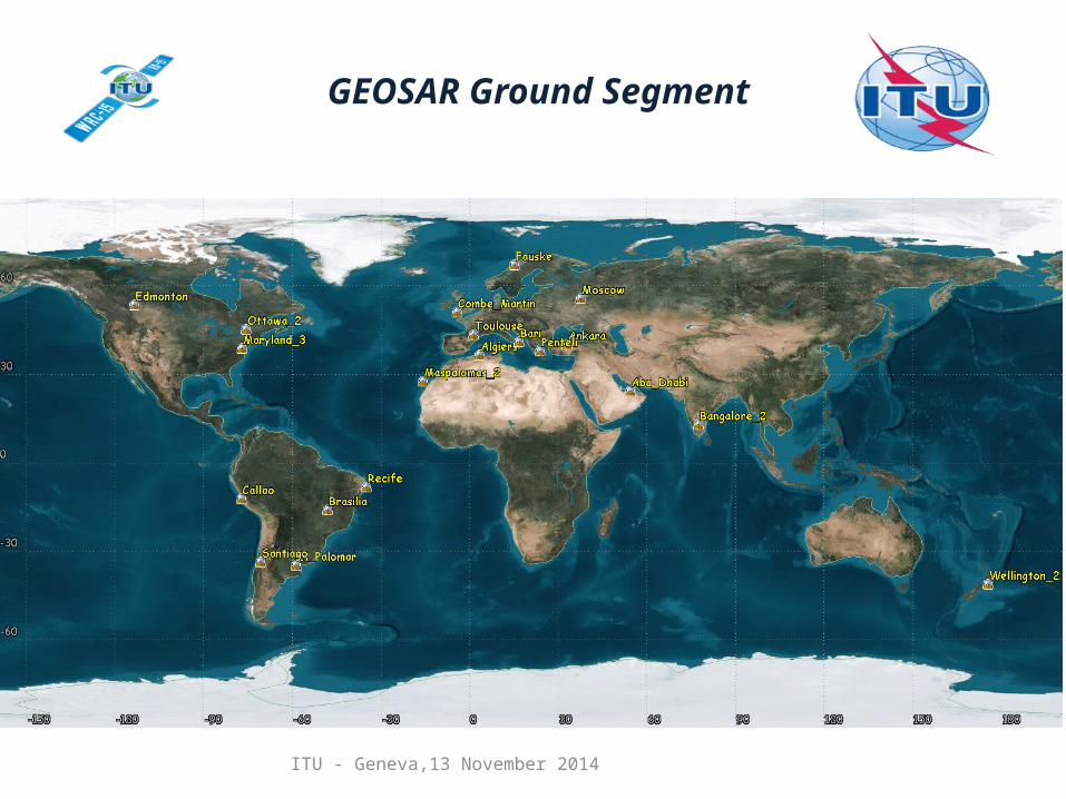
GEOSAR Ground Segment
ITU - Geneva,13 November 2014
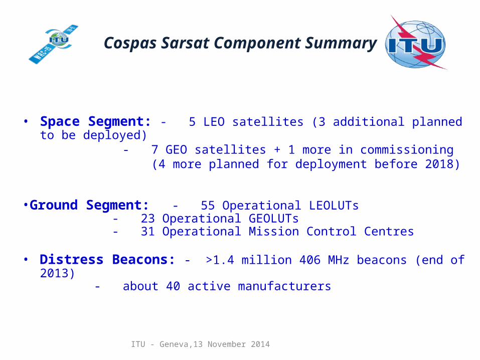
Cospas Sarsat Component Summary
• Space Segment: - 5 LEO satellites (3 additional planned to be deployed) - 7 GEO satellites + 1 more in commissioning (4 more planned for deployment before 2018)
•Ground Segment: - 55 Operational LEOLUTs - 23 Operational GEOLUTs - 31 Operational Mission Control Centres
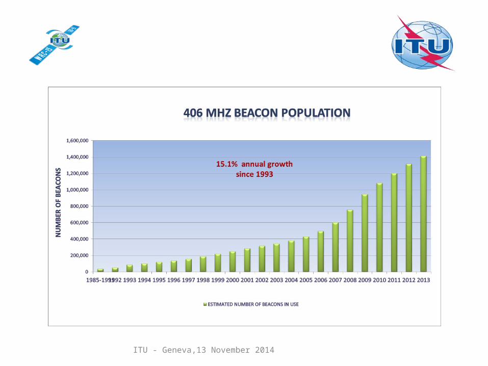
• Distress Beacons: - >1.4 million 406 MHz beacons (end of 2013)- about 40 active manufacturers
ITU - Geneva,13 November 2014
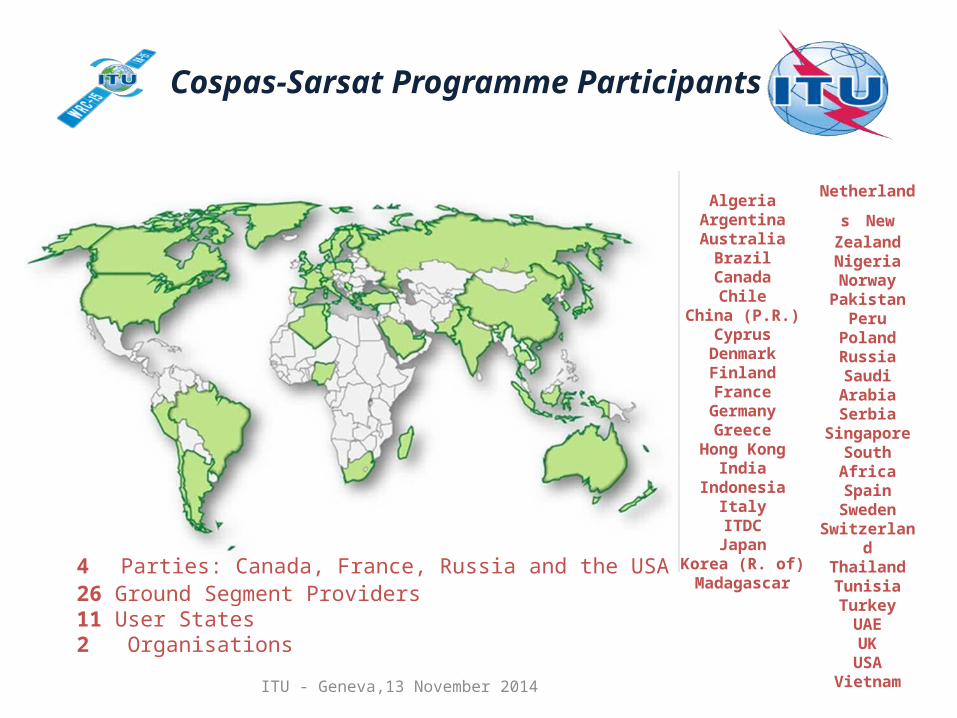
Cospas-Sarsat Programme Participants (2014)
AlgeriaArgentinaAustralia
BrazilCanada
ChileChina (P.R.)
CyprusDenmarkFinlandFrance
GermanyGreece
Hong KongIndia
IndonesiaItalyITDC
JapanKorea (R. of)Madagascar
Netherlands New Zealand
Nigeria NorwayPakistan
PeruPolandRussia
Saudi ArabiaSerbia
SingaporeSouth Africa
SpainSweden
SwitzerlandThailandTunisiaTurkeyUAEUK
USAVietnam
4 Parties: Canada, France, Russia and the USA26 Ground Segment Providers11 User States2 Organisations
ITU - Geneva,13 November 2014
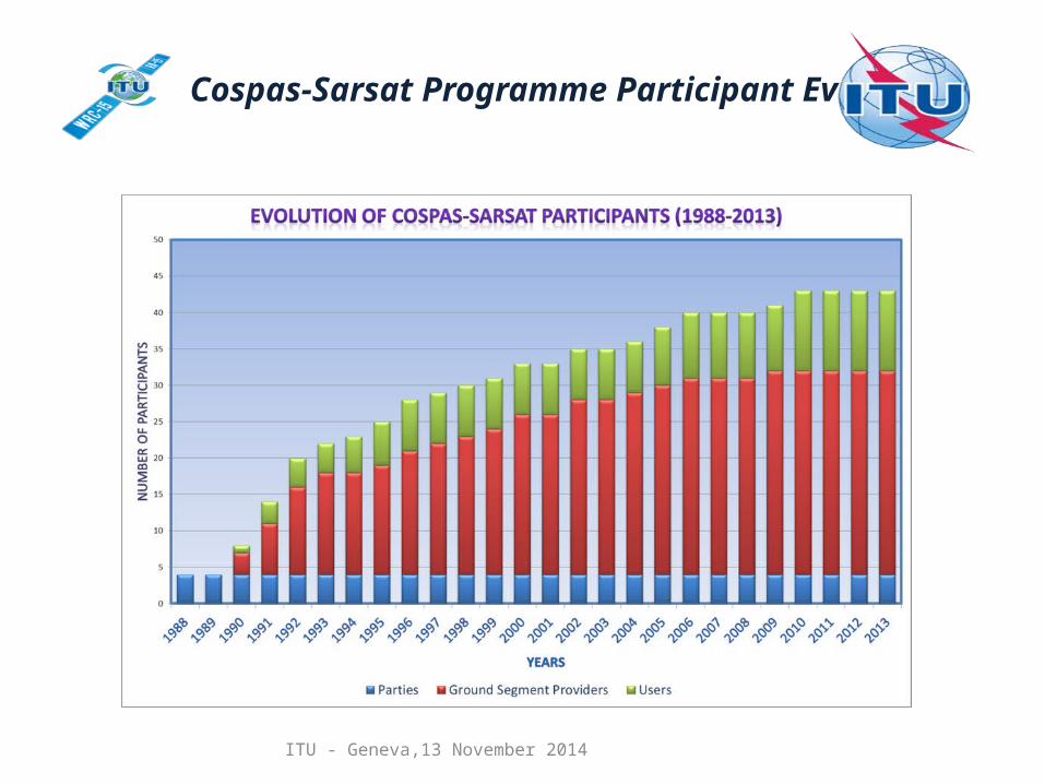
Cospas-Sarsat Programme Participant Evolution
ITU - Geneva,13 November 2014
ITU - Geneva,13 November 2014
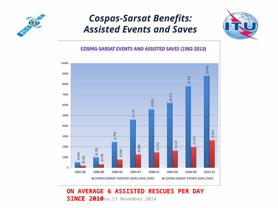
Cospas-Sarsat Benefits:Assisted Events and Saves
ON AVERAGE 6 ASSISTED RESCUES PER DAY SINCE 2010
ITU - Geneva,13 November 2014
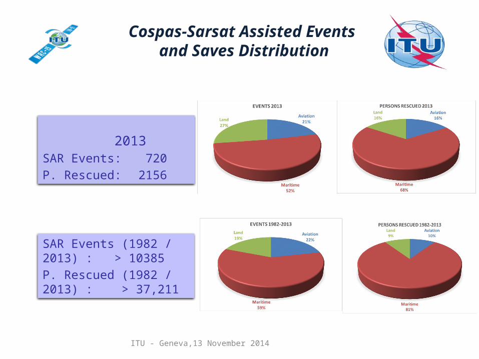
Cospas-Sarsat Assisted Events and Saves Distribution
SAR Events (1982 / 2013) : > 10385P. Rescued (1982 / 2013) : > 37,211
2013SAR Events: 720 P. Rescued: 2156
ITU - Geneva,13 November 2014
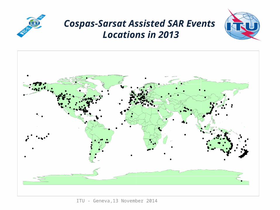
Cospas-Sarsat Assisted SAR Events Locations in 2013
ITU - Geneva,13 November 2014
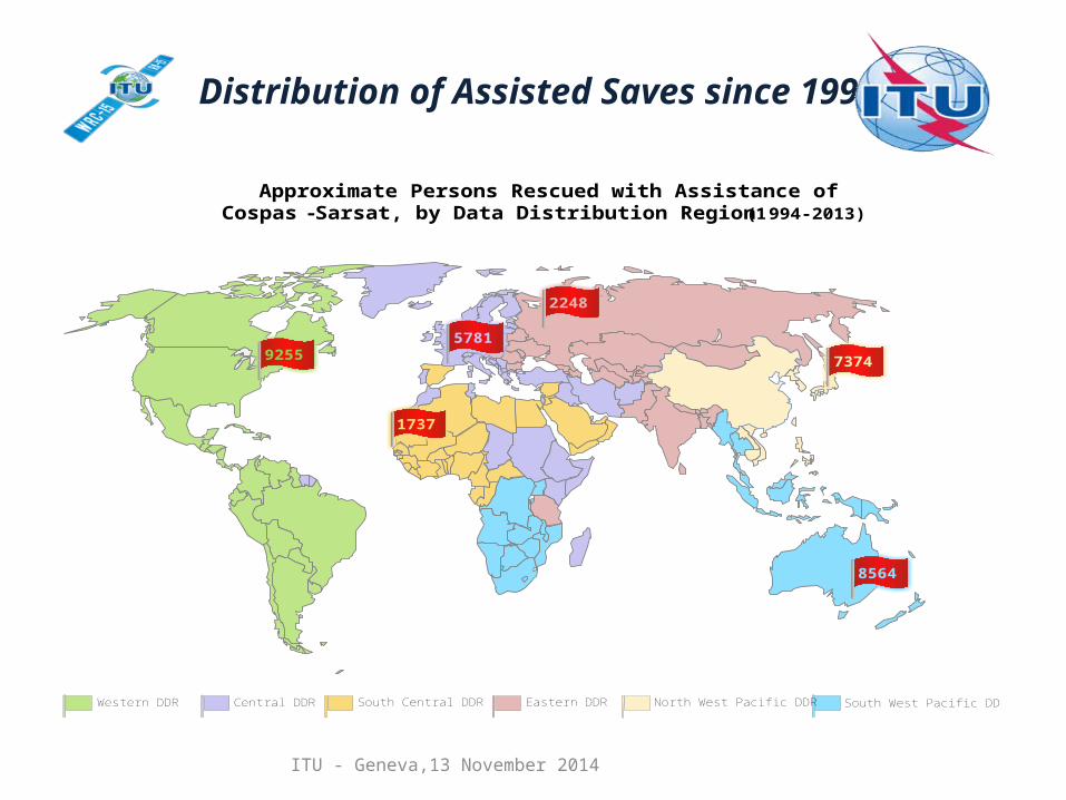
Distribution of Assisted Saves since 1994
Approximate Persons Rescued with Assistance ofCospas-Sarsat, by Data Distribution Region (1994-2013)
9255
1737
5781
2248
8564
Western DDR Central DDR South Central DDR Eastern DDR North West Pacific DDR South West Pacific DDR
7374
ITU - Geneva,13 November 2014
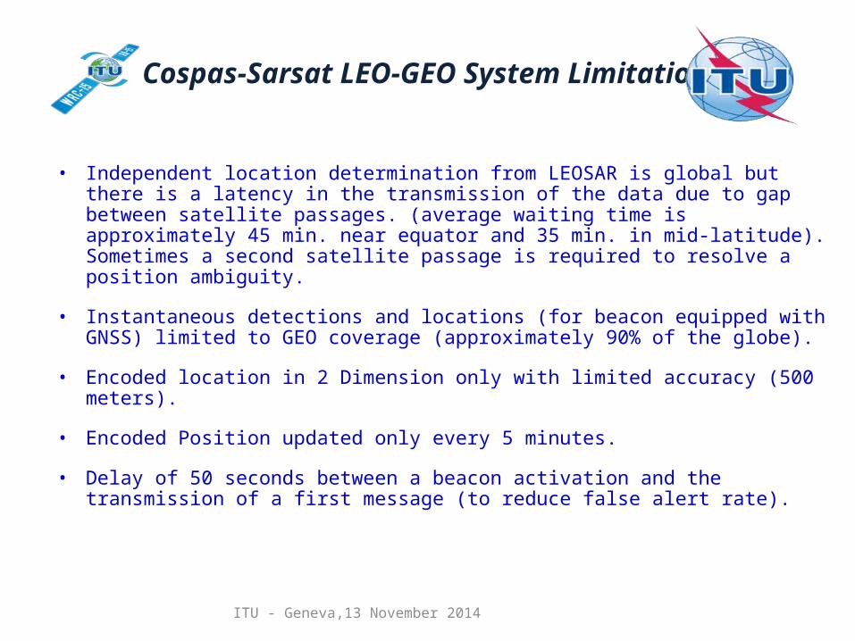
Cospas-Sarsat LEO-GEO System Limitations
• Independent location determination from LEOSAR is global but there is a latency in the transmission of the data due to gap between satellite passages. (average waiting time is approximately 45 min. near equator and 35 min. in mid-latitude). Sometimes a second satellite passage is required to resolve a position ambiguity.
• Instantaneous detections and locations (for beacon equipped with GNSS) limited to GEO coverage (approximately 90% of the globe).
• Encoded location in 2 Dimension only with limited accuracy (500 meters).
• Encoded Position updated only every 5 minutes.
• Delay of 50 seconds between a beacon activation and the transmission of a first message (to reduce false alert rate).
ITU - Geneva,13 November 2014
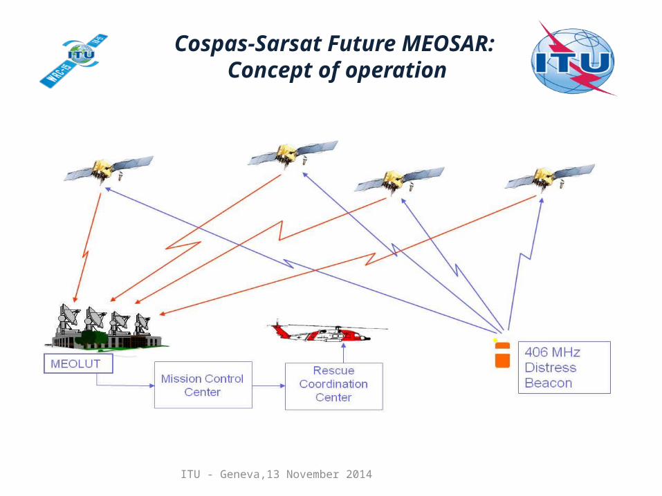
Cospas-Sarsat Future MEOSAR: Concept of operation
ITU - Geneva,13 November 2014
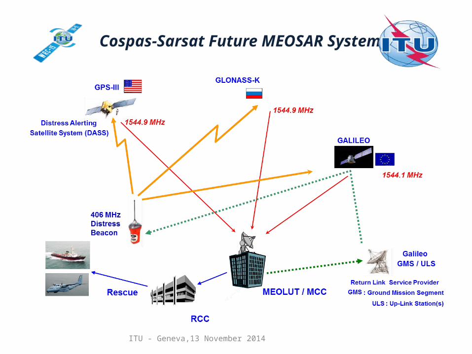
Cospas-Sarsat Future MEOSAR System
ITU - Geneva,13 November 2014
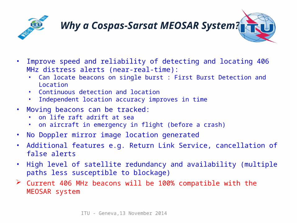
Why a Cospas-Sarsat MEOSAR System?
• Improve speed and reliability of detecting and locating 406 MHz distress alerts (near-real-time):• Can locate beacons on single burst : First Burst Detection and Location• Continuous detection and location• Independent location accuracy improves in time
• Moving beacons can be tracked:• on life raft adrift at sea• on aircraft in emergency in flight (before a crash)
• No Doppler mirror image location generated• Additional features e.g. Return Link Service, cancellation of false alerts• High level of satellite redundancy and availability (multiple paths less susceptible to
blockage) Current 406 MHz beacons will be 100% compatible with the MEOSAR system
ITU - Geneva,13 November 2014
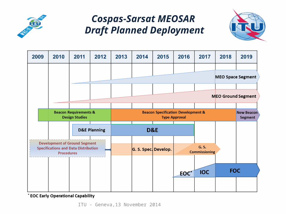
Cospas-Sarsat MEOSAR Draft Planned Deployment
ITU - Geneva,13 November 2014
Cospas-Sarsat MEOSAR Space Segment
• MEOSAR operational payloads (with L-Band downlink) will be mounted on three constellations of navigation satellites (Galileo, GPS III (9+), and Glonass K) providing more than 72 payloads in orbits after 2025.
• Today’s MEOSAR Development and Evaluation (D&E) is made primarily via non-operational DASS payloads (S-Band downlink) mounted on GPS II satellites. DASS payloads will also be utilized for MEOSAR pre-operational use.
• 16 DASS POC payloads (S-Band) are currently in orbit and an additional 12 payloads are expected to be deployed by 2019.
• Two L-Band MEOSAR payloads (part of future operational system) are currently available for MEOSAR use, one on Glonass K-1 satellite and on Galileo IOV satellite . A second Glonass K is expected to be deployed in 2014. More Galileo FM satellites are expected to be made available in 2015.
• Approximately 35 L-Band payloads are planned to be deployed for operational use by 2019.
ITU - Geneva,13 November 2014
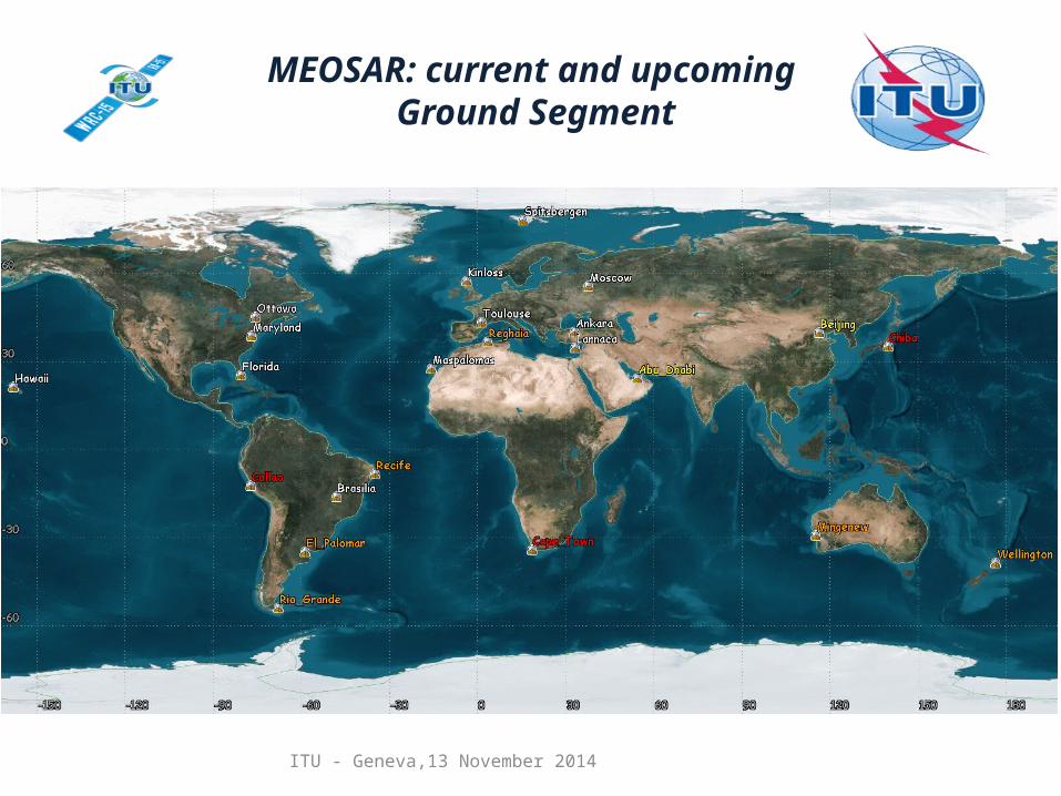
MEOSAR: current and upcoming Ground Segment
ITU - Geneva,13 November 2014
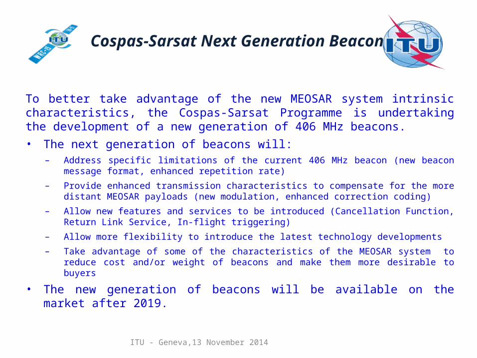
Cospas-Sarsat Next Generation Beacons
To better take advantage of the new MEOSAR system intrinsic characteristics, the Cospas-Sarsat Programme is undertaking the development of a new generation of 406 MHz beacons.• The next generation of beacons will:
– Address specific limitations of the current 406 MHz beacon (new beacon message format, enhanced repetition rate)
– Provide enhanced transmission characteristics to compensate for the more distant MEOSAR payloads (new modulation, enhanced correction coding)
– Allow new features and services to be introduced (Cancellation Function, Return Link Service, In-flight triggering)
– Allow more flexibility to introduce the latest technology developments– Take advantage of some of the characteristics of the MEOSAR system to reduce cost and/or weight of
beacons and make them more desirable to buyers
• The new generation of beacons will be available on the market after 2019.
ITU - Geneva,13 November 2014
Cospas-Sarsat Programme and frequency protection
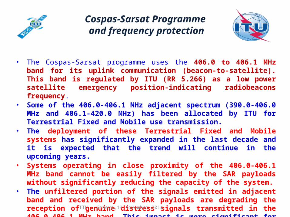
• The Cospas-Sarsat programme uses the 406.0 to 406.1 MHz band for its uplink communication (beacon-to-satellite). This band is regulated by ITU (RR 5.266) as a low power satellite emergency position-indicating radiobeacons frequency.
• Some of the 406.0-406.1 MHz adjacent spectrum (390.0-406.0 MHz and 406.1-420.0 MHz) has been allocated by ITU for Terrestrial Fixed and Mobile use transmission.
• The deployment of these Terrestrial Fixed and Mobile systems has significantly expanded in the last decade and it is expected that the trend will continue in the upcoming years.
• Systems operating in close proximity of the 406.0-406.1 MHz band cannot be easily filtered by the SAR payloads without significantly reducing the capacity of the system.
• The unfiltered portion of the signals emitted in adjacent band and received by the SAR payloads are degrading the reception of genuine distress signals transmitted in the 406.0-406.1 MHz band. This impact is more significant for the upcoming MEOSAR system which would be highly dependant to a clear reception of distress signals.
ITU - Geneva,13 November 2014
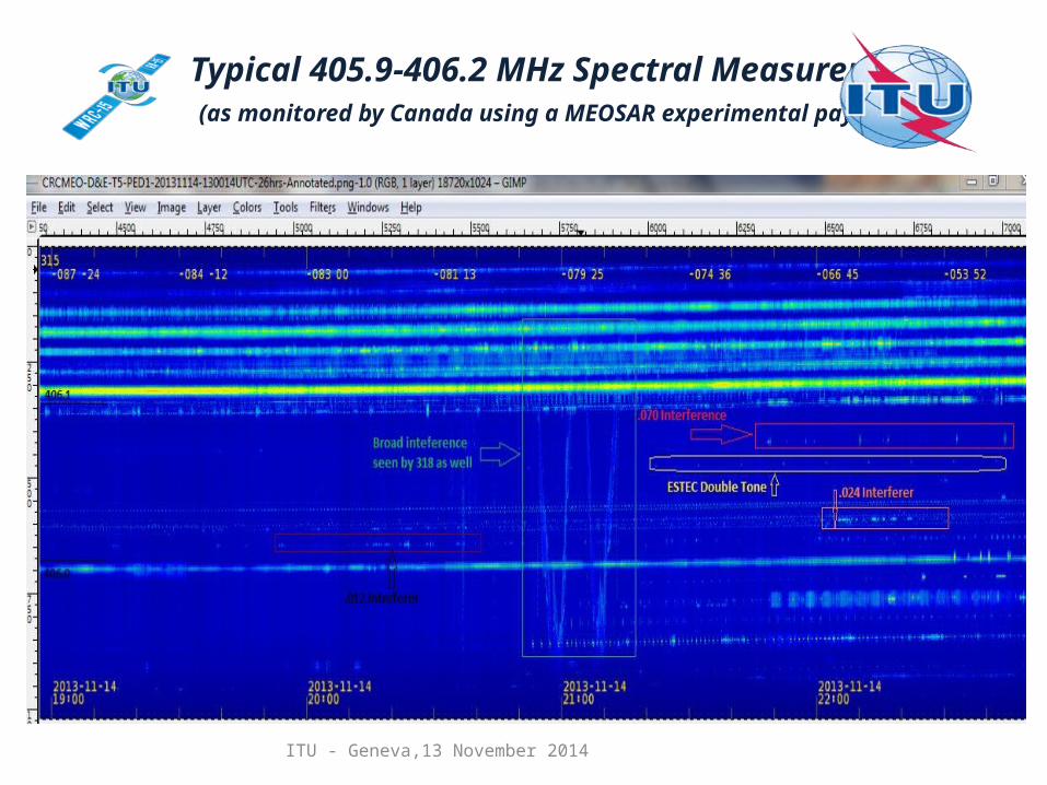
Typical 405.9-406.2 MHz Spectral Measurement (as monitored by Canada using a MEOSAR experimental payload)
ITU - Geneva,13 November 2014
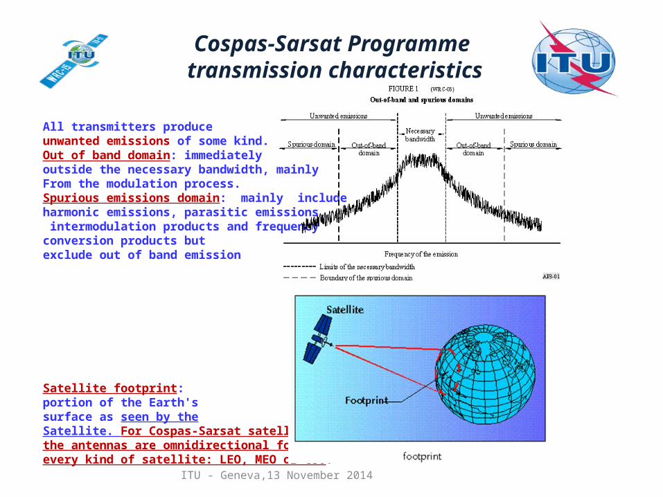
All transmitters produce unwanted emissions of some kind.Out of band domain: immediately outside the necessary bandwidth, mainly From the modulation process.Spurious emissions domain: mainly include harmonic emissions, parasitic emissions, intermodulation products and frequency conversion products but exclude out of band emission
Satellite footprint: portion of the Earth'ssurface as seen by theSatellite. For Cospas-Sarsat satellites,the antennas are omnidirectional for every kind of satellite: LEO, MEO or GSO.
Cospas-Sarsat Programme transmission characteristics
ITU - Geneva,13 November 2014
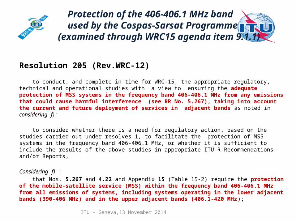
Resolution 205 (Rev.WRC-12)
to conduct, and complete in time for WRC-15, the appropriate regulatory, technical and operational studies with a view to ensuring the adequate protection of MSS systems in the frequency band 406-406.1 MHz from any emissions that could cause harmful interference (see RR No. 5.267), taking into account the current and future deployment of services in adjacent bands as noted in considering f);
to consider whether there is a need for regulatory action, based on the studies carried out under resolves 1, to facilitate the protection of MSS systems in the frequency band 406-406.1 MHz, or whether it is sufficient to include the results of the above studies in appropriate ITU-R Recommendations and/or Reports, Considering f) :
that Nos. 5.267 and 4.22 and Appendix 15 (Table 15-2) require the protection of the mobile-satellite service (MSS) within the frequency band 406-406.1 MHz from all emissions of systems, including systems operating in the lower adjacent bands (390-406 MHz) and in the upper adjacent bands (406.1-420 MHz);
Protection of the 406-406.1 MHz band used by the Cospas-Sarsat Programme (examined through WRC15 agenda item 9.1.1)
ITU - Geneva,13 November 2014
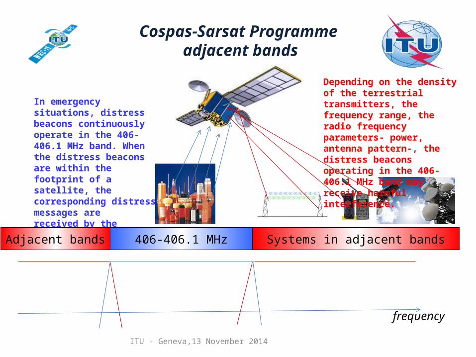
406-406.1 MHz
frequency
In emergency situations, distress beacons continuously operate in the 406-406.1 MHz band. When the distress beacons are within the footprint of a satellite, the corresponding distress messages arereceived by the satellite.
Depending on the density of the terrestrial transmitters, the frequency range, the radio frequency parameters- power, antenna pattern-, the distress beacons operating in the 406-406.1 MHz band may receive harmful interference.
Systems in adjacent bandsAdjacent bands
Cospas-Sarsat Programme adjacent bands
ITU - Geneva,13 November 2014
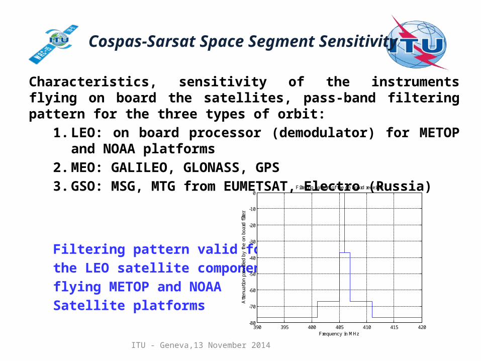
Characteristics, sensitivity of the instruments flying on board the satellites, pass-band filtering pattern for the three types of orbit:
1. LEO: on board processor (demodulator) for METOP and NOAA platforms
2. MEO: GALILEO, GLONASS, GPS3. GSO: MSG, MTG from EUMETSAT, Electro (Russia)
Filtering pattern valid for the LEO satellite componentflying METOP and NOAA Satellite platforms
390 395 400 405 410 415 420-80
-70
-60
-50
-40
-30
-20
-10
0
Frequency in MHz
Atte
nuat
ion
prov
ided
by
the
on b
oard
filte
r
Filtering pattern of the on board receiver
Cospas-Sarsat Space Segment Sensitivity
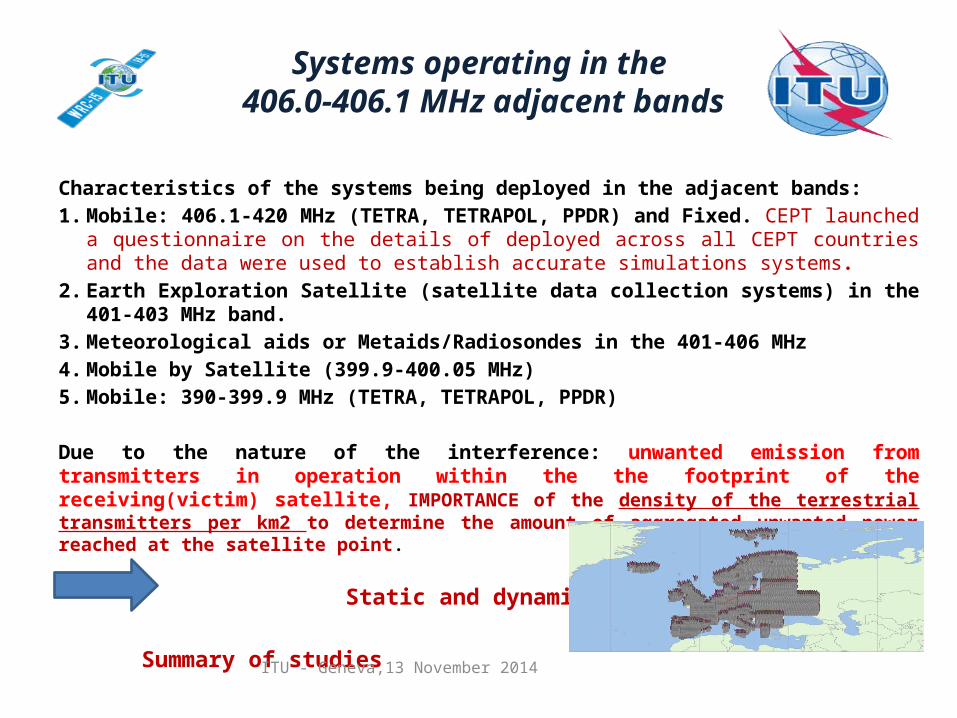
Characteristics of the systems being deployed in the adjacent bands:1. Mobile: 406.1-420 MHz (TETRA, TETRAPOL, PPDR) and Fixed. CEPT launched a
questionnaire on the details of deployed across all CEPT countries and the data were used to establish accurate simulations systems.
2. Earth Exploration Satellite (satellite data collection systems) in the 401-403 MHz band.3. Meteorological aids or Metaids/Radiosondes in the 401-406 MHz4. Mobile by Satellite (399.9-400.05 MHz) 5. Mobile: 390-399.9 MHz (TETRA, TETRAPOL, PPDR)
Due to the nature of the interference: unwanted emission from transmitters in operation within the the footprint of the receiving(victim) satellite, IMPORTANCE of the density of the terrestrial transmitters per km2 to determine the amount of aggregated unwanted power reached at the satellite point.
Static and dynamic simulations
Summary of studiesITU - Geneva,13 November 2014
Systems operating in the 406.0-406.1 MHz adjacent bands
ITU - Geneva,13 November 2014
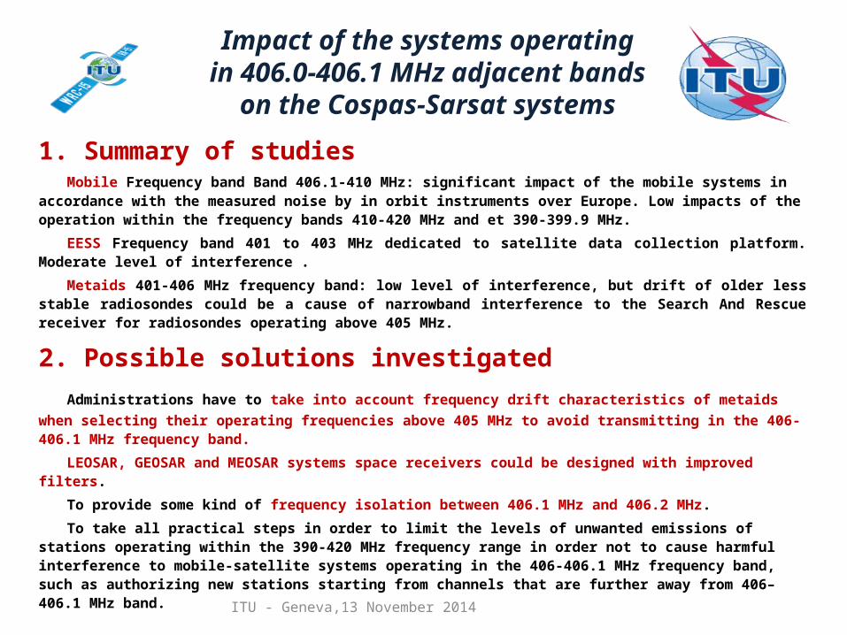
1. Summary of studiesMobile Frequency band Band 406.1-410 MHz: significant impact of the mobile systems in accordance
with the measured noise by in orbit instruments over Europe. Low impacts of the operation within the frequency bands 410-420 MHz and et 390-399.9 MHz.
EESS Frequency band 401 to 403 MHz dedicated to satellite data collection platform. Moderate level of interference .
Metaids 401-406 MHz frequency band: low level of interference, but drift of older less stable radiosondes could be a cause of narrowband interference to the Search And Rescue receiver for radiosondes operating above 405 MHz.
2. Possible solutions investigatedAdministrations have to take into account frequency drift characteristics of metaids when selecting their
operating frequencies above 405 MHz to avoid transmitting in the 406-406.1 MHz frequency band.
LEOSAR, GEOSAR and MEOSAR systems space receivers could be designed with improved filters.
To provide some kind of frequency isolation between 406.1 MHz and 406.2 MHz.
To take all practical steps in order to limit the levels of unwanted emissions of stations operating within the 390-420 MHz frequency range in order not to cause harmful interference to mobile-satellite systems operating in the 406-406.1 MHz frequency band, such as authorizing new stations starting from channels that are further away from 406–406.1 MHz band.
Impact of the systems operating in 406.0-406.1 MHz adjacent bands
on the Cospas-Sarsat systems
ITU - Geneva,13 November 2014
Thank you for your attention