Embed Size (px)
Citation preview
CORS USERS FORUM
Richard Snay
NOAA’s National Geodetic Survey
CGSIC Meeting
Fort Worth, TX
September 26, 2006
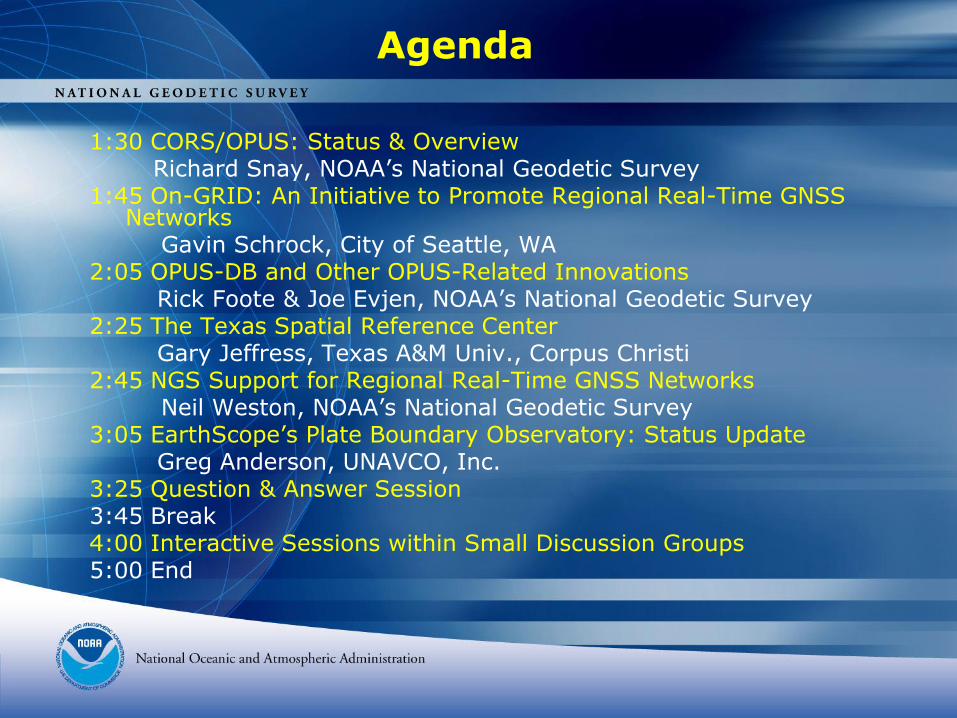
Agenda
1:30 CORS/OPUS: Status & OverviewRichard Snay, NOAA’s National Geodetic Survey
1:45 On-GRID: An Initiative to Promote Regional Real-Time GNSS Networks
Gavin Schrock, City of Seattle, WA2:05 OPUS-DB and Other OPUS-Related Innovations
Rick Foote & Joe Evjen, NOAA’s National Geodetic Survey2:25 The Texas Spatial Reference Center
Gary Jeffress, Texas A&M Univ., Corpus Christi2:45 NGS Support for Regional Real-Time GNSS Networks
Neil Weston, NOAA’s National Geodetic Survey3:05 EarthScope’s Plate Boundary Observatory: Status Update
Greg Anderson, UNAVCO, Inc.3:25 Question & Answer Session3:45 Break4:00 Interactive Sessions within Small Discussion Groups5:00 End

Interactive Sessions (4:00 – 5:00 pm)
A. Supporting real-time positioningNeil Weston, Giovanni Sella and Bill Henning
B. OPUSJoe Evjen and Rick Foote
C. Texas Spatial Reference CenterCliff Middleton and Casey Brennan
D. Ionospheric modelsJoe Kunches
E. Tropospheric modelsSeth Gutman

Continuously Operating Reference Stations

CORS OVERVIEW
• National CORS Network contains 817 sites
• Cooperative CORS Network contains 168 sites
• California CORS Network contains 350+ sites
• Combined CORS Network growing at rate of 15 sites per month
• More than 180 organizations participate in the CORS program
• Provides code range (C/A, P1, P2)
– and carrier phase observations (L1, L2)

CORS APPLICATIONS
• Postmission Static Positioning (cm-level accuracy with a few hours of data, dm-level accuracy with one minute of data)
• Postmission Kinematic Positioning (dm-level accuracy for an aircraft, boat, or land vehicle)
• Geophysics / Crustal Motion
• Meteorology / Water Vapor in Atmosphere
• Space Weather / Free Electrons in Ionosphere
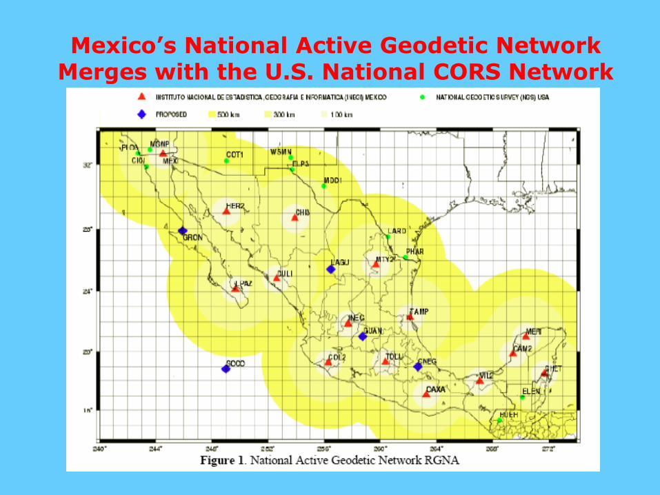
Mexico’s National Active Geodetic NetworkMerges with the U.S. National CORS Network
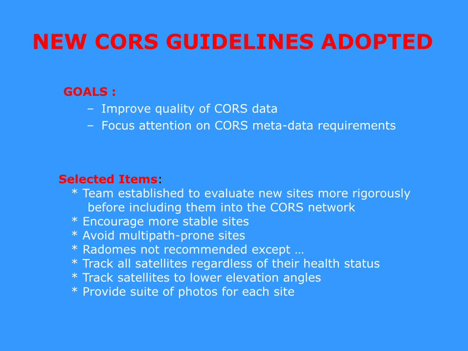
NEW CORS GUIDELINES ADOPTED
GOALS :
– Improve quality of CORS data
– Focus attention on CORS meta-data requirements
Selected Items:* Team established to evaluate new sites more rigorously
before including them into the CORS network* Encourage more stable sites* Avoid multipath-prone sites* Radomes not recommended except …* Track all satellites regardless of their health status* Track satellites to lower elevation angles* Provide suite of photos for each site
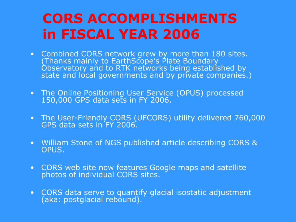
CORS ACCOMPLISHMENTS in FISCAL YEAR 2006
• Combined CORS network grew by more than 180 sites. (Thanks mainly to EarthScope’s Plate Boundary Observatory and to RTK networks being established by state and local governments and by private companies.)
• The Online Positioning User Service (OPUS) processed 150,000 GPS data sets in FY 2006.
• The User-Friendly CORS (UFCORS) utility delivered 760,000 GPS data sets in FY 2006.
• William Stone of NGS published article describing CORS & OPUS.
• CORS web site now features Google maps and satellite photos of individual CORS sites.
• CORS data serve to quantify glacial isostatic adjustment (aka: postglacial rebound).
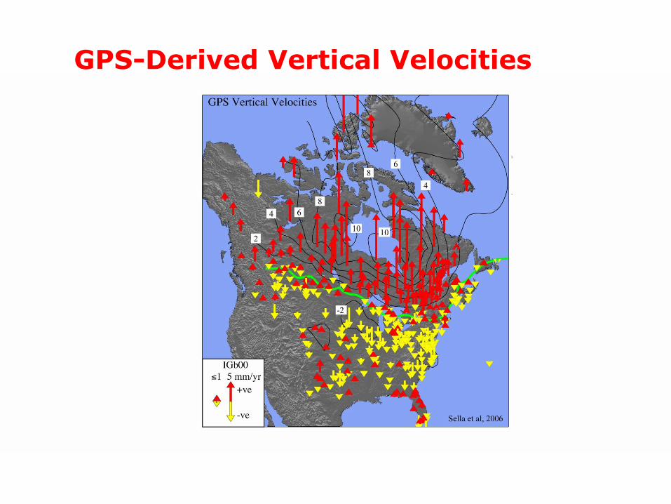
GPS-Derived Vertical Velocities

US-TEC Product:http://www.sec.noaa.gov/ustec
Real-time ionospheric maps of total electron content updated every 15
minutes. Currently uses about 110 real-time GPS stations from the
CORS, GPS/MET, and Canadian rtIGS networks.
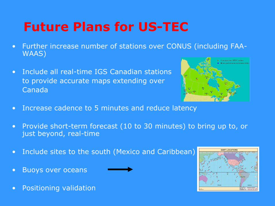
Future Plans for US-TEC
• Further increase number of stations over CONUS (including FAA-WAAS)
• Include all real-time IGS Canadian stations
to provide accurate maps extending over
Canada
• Increase cadence to 5 minutes and reduce latency
• Provide short-term forecast (10 to 30 minutes) to bring up to, or just beyond, real-time
• Include sites to the south (Mexico and Caribbean)
• Buoys over oceans
• Positioning validation

NOAATrop: Product Overview
• Available now for real-time correction of
positioning and navigation errors caused by
the neutral (non-dispersive) atmosphere.
• NOAATrop is currently a 1-D model available
for download at:
ftp://aftp.fsl.noaa.gov/gpsmet/zwdgrids/.
• Provides ZWD and ALT (a proxy for ZHD)
grids with 13 km resolution over CONUS
domain.
• NOAATrop is based on RUC, an operational
model that is updated hourly.
• 2DRMS accuracy of model is currently 2 cm
in cold season and < 4 cm in warm season.
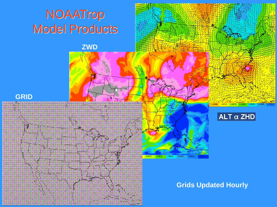
GRID
ZWD
NOAATrop
Model Products
Grids Updated Hourly

NOAATrop: Product Overview
• Here’s how it works:
user provides approximate ;
product interpolates ZWD to
at time t;
product (1) interpolates ALT to
at time t, (2) uses GEOID03 and h to
calculate H, then (3) calculates ZHD
from ALT using and H;
product returns ZHD and ZWD at time t;
user then scales ZHD and ZWD to the
elevation (E) of each satellite using the
Neill Mapping Function or similar
technique.
ON THE CORS HORIZON
* NOAA will determine ITRF 2005 positional coordinates and velocities for all CORS sites.
* NOAA will add about 10 GPS/GLONASS receivers to CORS network.
* NOAA will establish CORS sites at about 6 additional U.S. tide gauge stations.
* NOAA will publish a scientific article on the use of CORS data to calibrate tide gauge data for determining absolute sea level rise.
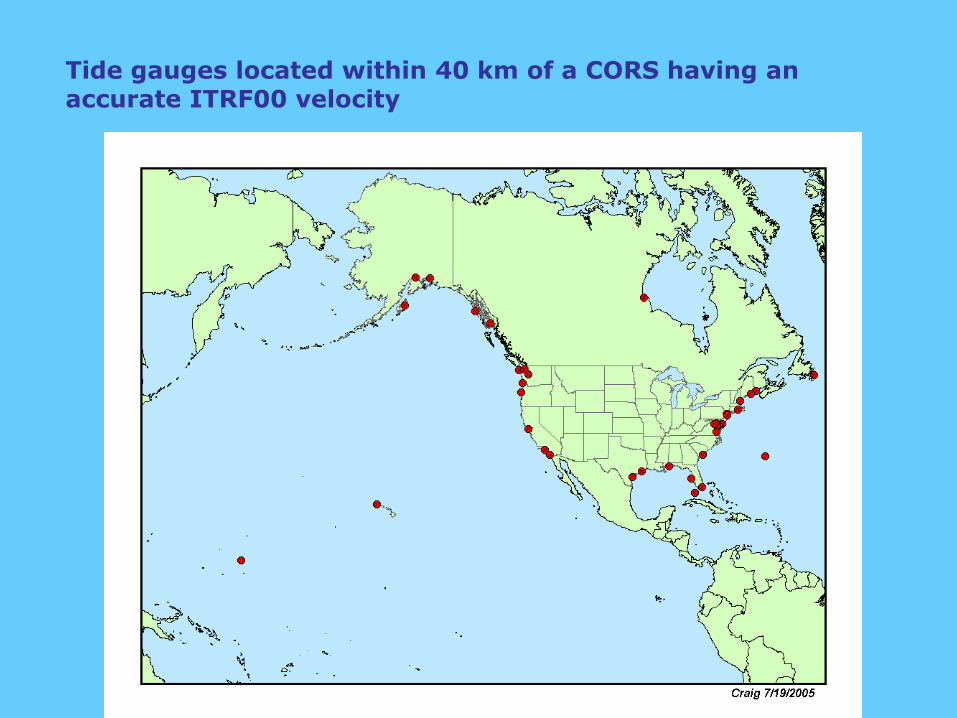
Tide gauges located within 40 km of a CORS having an accurate ITRF00 velocity
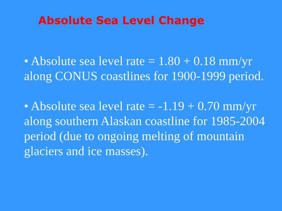
Absolute Sea Level Change
• Absolute sea level rate = 1.80 + 0.18 mm/yr
along CONUS coastlines for 1900-1999 period.
• Absolute sea level rate = -1.19 + 0.70 mm/yr
along southern Alaskan coastline for 1985-2004
period (due to ongoing melting of mountain
glaciers and ice masses).


![CORS Program FY0945]09... · 2009-10-01 · CORS Program FY09 Giovanni Sella CORS Program Manager NOAA- National Geodetic Survey giovanni.sella @ noaa.gov CGSIC Savannah, GA CORS](https://img.pdfslide.us/doc/110x75/5f09f82f7e708231d4296126/cors-program-4509-2009-10-01-cors-program-fy09-giovanni-sella-cors-program.jpg)