Embed Size (px)
Citation preview
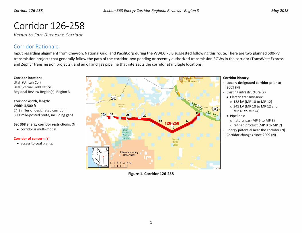
Corridor 126-258 Section 368 Energy Corridor Regional Reviews - Region 3 May 2018
1
Corridor 126-258 Vernal to Fort Duchesne Corridor
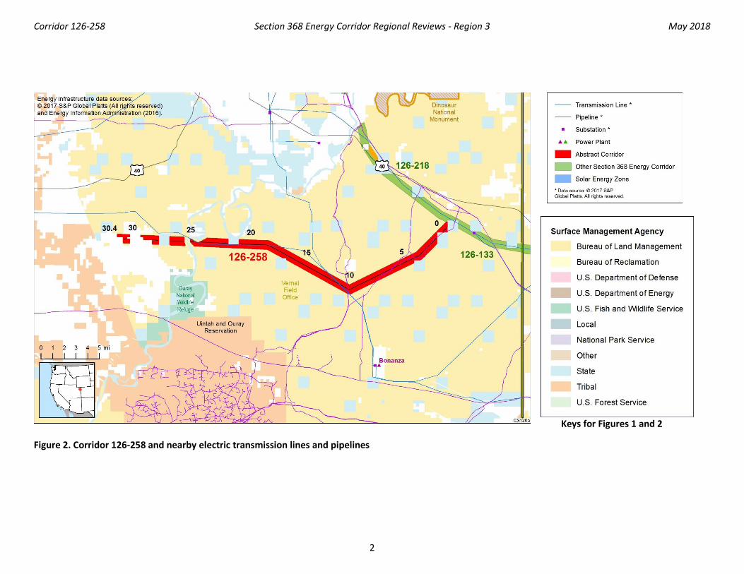
Corridor Rationale Input regarding alignment from Chevron, National Grid, and PacifiCorp during the WWEC PEIS suggested following this route. There are two planned 500-kV transmission projects that generally follow the path of the corridor, two pending or recently authorized transmission ROWs in the corridor (TransWest Express and Zephyr transmission projects), and an oil and gas pipeline that intersects the corridor at multiple locations.
Corridor location: Utah (Uintah Co.) BLM: Vernal Field Office Regional Review Region(s): Region 3 Corridor width, length: Width 3,500 ft 24.3 miles of designated corridor 30.4 mile-posted route, including gaps Sec 368 energy corridor restrictions: (N) • corridor is multi-modal
Corridor of concern (Y) • access to coal plants.
Corridor history: - Locally designated corridor prior to
2009 (N) - Existing infrastructure (Y) • Electric transmission: o 138 kV (MP 10 to MP 12) o 345 kV (MP 10 to MP 12 and
MP 18 to MP 24) • Pipelines: o natural gas (MP 5 to MP 8) o refined product (MP 0 to MP 7)
- Energy potential near the corridor (N) - Corridor changes since 2009 (N)
Figure 1. Corridor 126-258
Corridor 126-258 Section 368 Energy Corridor Regional Reviews - Region 3 May 2018
2
Keys for Figures 1 and 2
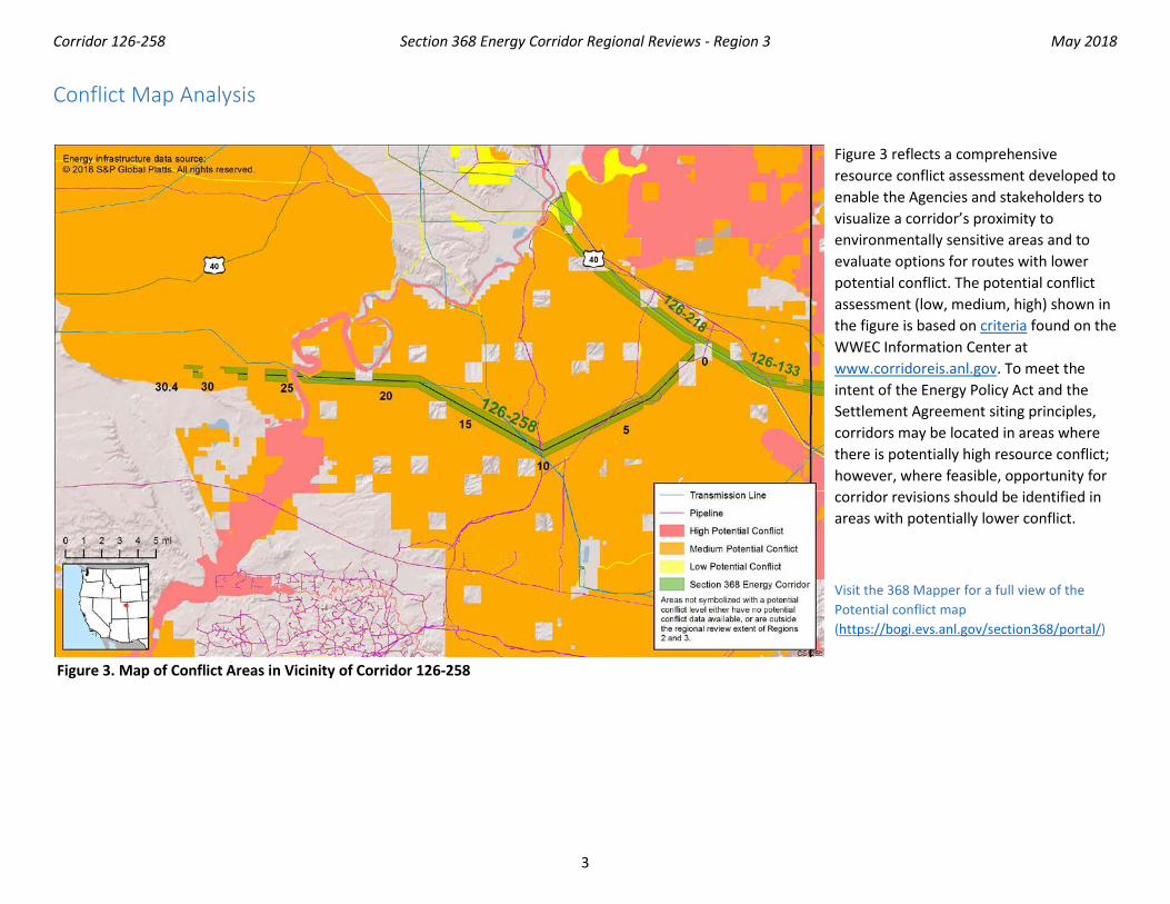
Figure 2. Corridor 126-258 and nearby electric transmission lines and pipelines
Corridor 126-258 Section 368 Energy Corridor Regional Reviews - Region 3 May 2018
3
Conflict Map Analysis
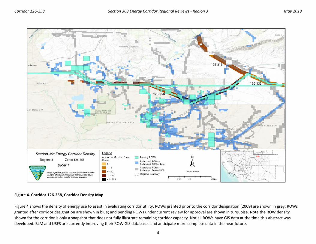
Figure 3. Map of Conflict Areas in Vicinity of Corridor 126-258
Figure 3 reflects a comprehensive resource conflict assessment developed to enable the Agencies and stakeholders to visualize a corridor’s proximity to environmentally sensitive areas and to evaluate options for routes with lower potential conflict. The potential conflict assessment (low, medium, high) shown in the figure is based on criteria found on the WWEC Information Center at www.corridoreis.anl.gov. To meet the intent of the Energy Policy Act and the Settlement Agreement siting principles, corridors may be located in areas where there is potentially high resource conflict; however, where feasible, opportunity for corridor revisions should be identified in areas with potentially lower conflict.
Visit the 368 Mapper for a full view of the Potential conflict map (https://bogi.evs.anl.gov/section368/portal/)
Corridor 126-258 Section 368 Energy Corridor Regional Reviews - Region 3 May 2018
4
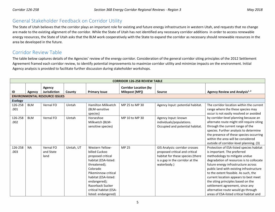
Figure 4. Corridor 126-258, Corridor Density Map
Figure 4 shows the density of energy use to assist in evaluating corridor utility. ROWs granted prior to the corridor designation (2009) are shown in grey; ROWs granted after corridor designation are shown in blue; and pending ROWs under current review for approval are shown in turquoise. Note the ROW density shown for the corridor is only a snapshot that does not fully illustrate remaining corridor capacity. Not all ROWs have GIS data at the time this abstract was developed. BLM and USFS are currently improving their ROW GIS databases and anticipate more complete data in the near future.
Corridor 126-258 Section 368 Energy Corridor Regional Reviews - Region 3 May 2018
5
General Stakeholder Feedback on Corridor Utility The State of Utah believes that the corridor plays an important role for existing and future energy infrastructure in western Utah, and requests that no change are made to the existing alignment of the corridor. While the State of Utah has not identified any necessary corridor additions in order to access renewable energy resources, the State of Utah asks that the BLM work cooperatively with the State to expand the corridor as necessary should renewable resources in the area be developed in the future.
Corridor Review Table The table below captures details of the Agencies’ review of the energy corridor. Consideration of the general corridor siting principles of the 2012 Settlement Agreement framed each corridor review, to identify potential improvements to maximize corridor utility and minimize impacts on the environment. Initial Agency analysis is provided to facilitate further discussion during stakeholder workshops.
CORRIDOR 126-258 REVIEW TABLE
ID Agency Agency Jurisdiction
County Primary Issue
Corridor Location (by Milepost [MP]) Source Agency Review and Analysis1, 2
ENVIRONMENTAL RESOURCE ISSUES Ecology 126-258 .001
BLM Vernal FO Uintah Hamilton Milkvetch (BLM-sensitive species)
MP 25 to MP 30 Agency Input: potential habitat. The corridor location within the current range where the these species may occur is not easily resolved or avoided by corridor-level planning because an alternate route might still require siting through the current range of the species. Further analysis to determine the presence of these species occurring within the area will be considered outside of corridor-level planning. (3)
126-258 .002
BLM Vernal FO Uintah Horseshoe Milkvetch (BLM-sensitive species)
MP 10 to MP 30 Agency Input: known individuals/populations. Occupied and potential habitat.
126-258 .003
NA Vernal FO and State land
Uintah, UT Western Yellow-billed Cuckoo proposed critical habitat (ESA-listed: threatened); Colorado Pikeminnow critical habitat (ESA-listed: endangered); Razorback Sucker critical habitat (ESA-listed: endangered)
MP 25 GIS Analysis: corridor crosses proposed critical and critical habitat for these species (there is a gap in the corridor at the waterbody.)
Protection of ESA-listed species habitat is important. The preferred methodology to mitigate undue degradation of resources is to collocate future energy infrastructure across public land with existing infrastructure to the extent feasible. As such, the current location appears to best meet the siting principles based on the settlement agreement, since any alternative route would go through areas of ESA-listed critical habitat and
Corridor 126-258 Section 368 Energy Corridor Regional Reviews - Region 3 May 2018
6
CORRIDOR 126-258 REVIEW TABLE
ID Agency Agency Jurisdiction
County Primary Issue
Corridor Location (by Milepost [MP]) Source Agency Review and Analysis1, 2
would not lend-itself to collocation and would further fragment critical habitat. (1)
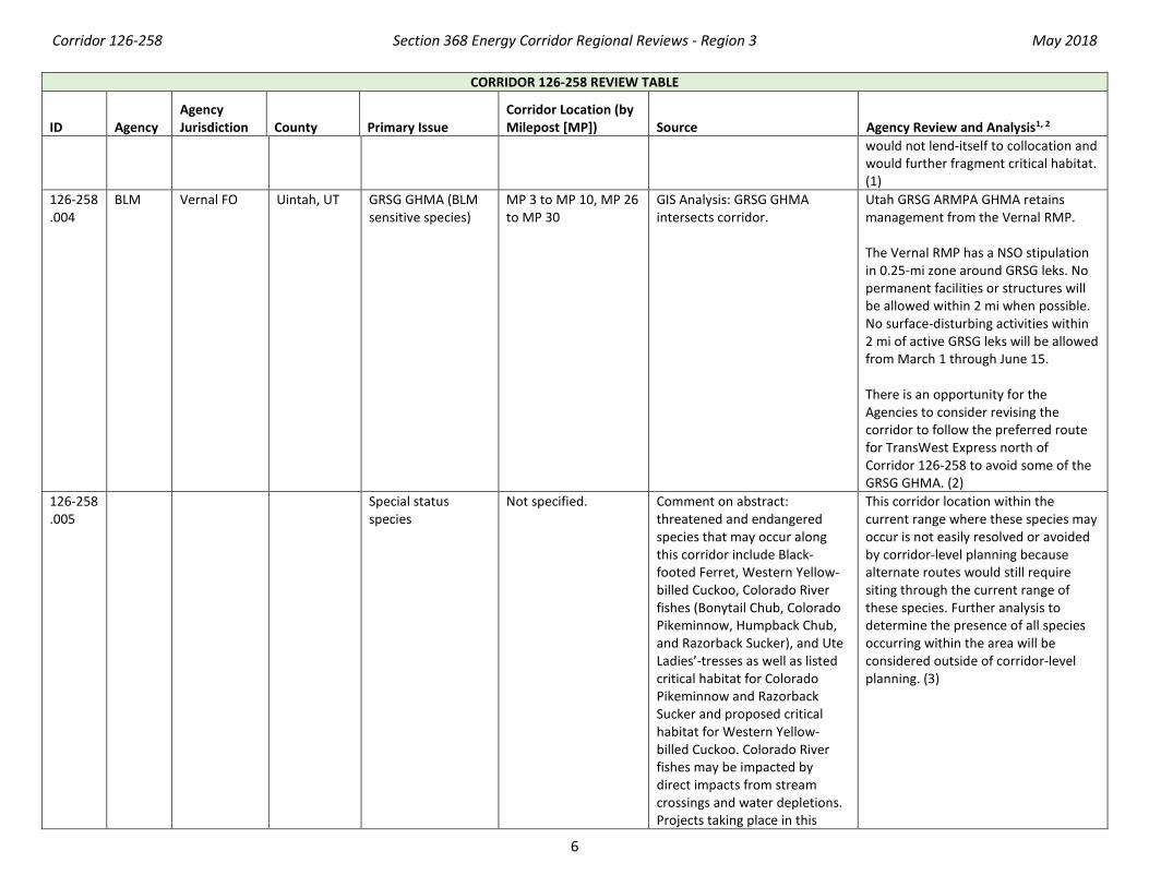
126-258 .004
BLM Vernal FO Uintah, UT GRSG GHMA (BLM sensitive species)
MP 3 to MP 10, MP 26 to MP 30
GIS Analysis: GRSG GHMA intersects corridor.
Utah GRSG ARMPA GHMA retains management from the Vernal RMP. The Vernal RMP has a NSO stipulation in 0.25-mi zone around GRSG leks. No permanent facilities or structures will be allowed within 2 mi when possible. No surface-disturbing activities within 2 mi of active GRSG leks will be allowed from March 1 through June 15. There is an opportunity for the Agencies to consider revising the corridor to follow the preferred route for TransWest Express north of Corridor 126-258 to avoid some of the GRSG GHMA. (2)
126-258 .005
Special status species
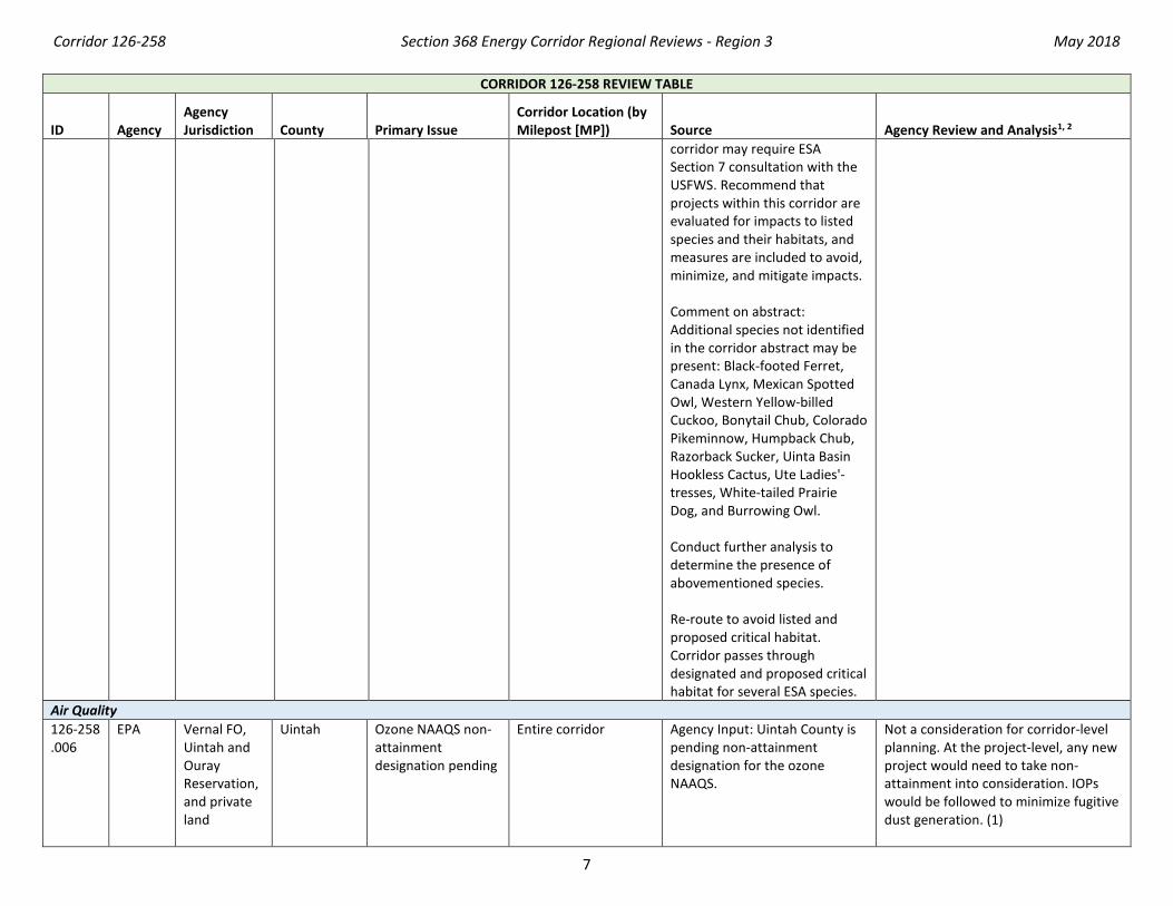
Not specified. Comment on abstract: threatened and endangered species that may occur along this corridor include Black-footed Ferret, Western Yellow-billed Cuckoo, Colorado River fishes (Bonytail Chub, Colorado Pikeminnow, Humpback Chub, and Razorback Sucker), and Ute Ladies’-tresses as well as listed critical habitat for Colorado Pikeminnow and Razorback Sucker and proposed critical habitat for Western Yellow-billed Cuckoo. Colorado River fishes may be impacted by direct impacts from stream crossings and water depletions. Projects taking place in this
This corridor location within the current range where these species may occur is not easily resolved or avoided by corridor-level planning because alternate routes would still require siting through the current range of these species. Further analysis to determine the presence of all species occurring within the area will be considered outside of corridor-level planning. (3)
Corridor 126-258 Section 368 Energy Corridor Regional Reviews - Region 3 May 2018
7
CORRIDOR 126-258 REVIEW TABLE
ID Agency Agency Jurisdiction
County Primary Issue
Corridor Location (by Milepost [MP]) Source Agency Review and Analysis1, 2
corridor may require ESA Section 7 consultation with the USFWS. Recommend that projects within this corridor are evaluated for impacts to listed species and their habitats, and measures are included to avoid, minimize, and mitigate impacts. Comment on abstract: Additional species not identified in the corridor abstract may be present: Black-footed Ferret, Canada Lynx, Mexican Spotted Owl, Western Yellow-billed Cuckoo, Bonytail Chub, Colorado Pikeminnow, Humpback Chub, Razorback Sucker, Uinta Basin Hookless Cactus, Ute Ladies'-tresses, White-tailed Prairie Dog, and Burrowing Owl. Conduct further analysis to determine the presence of abovementioned species. Re-route to avoid listed and proposed critical habitat. Corridor passes through designated and proposed critical habitat for several ESA species.
Air Quality 126-258 .006
EPA Vernal FO, Uintah and Ouray Reservation, and private land
Uintah Ozone NAAQS non-attainment designation pending
Entire corridor Agency Input: Uintah County is pending non-attainment designation for the ozone NAAQS.
Not a consideration for corridor-level planning. At the project-level, any new project would need to take non-attainment into consideration. IOPs would be followed to minimize fugitive dust generation. (1)
Corridor 126-258 Section 368 Energy Corridor Regional Reviews - Region 3 May 2018
8
CORRIDOR 126-258 REVIEW TABLE
ID Agency Agency Jurisdiction
County Primary Issue
Corridor Location (by Milepost [MP]) Source Agency Review and Analysis1, 2
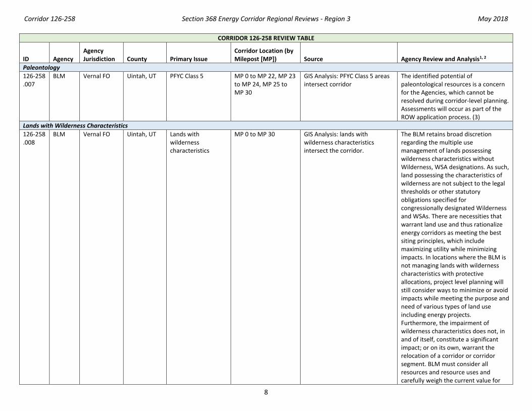
Paleontology 126-258 .007
BLM Vernal FO Uintah, UT PFYC Class 5 MP 0 to MP 22, MP 23 to MP 24, MP 25 to MP 30
GIS Analysis: PFYC Class 5 areas intersect corridor
The identified potential of paleontological resources is a concern for the Agencies, which cannot be resolved during corridor-level planning. Assessments will occur as part of the ROW application process. (3)
Lands with Wilderness Characteristics 126-258 .008
BLM Vernal FO Uintah, UT Lands with wilderness characteristics
MP 0 to MP 30 GIS Analysis: lands with wilderness characteristics intersect the corridor.
The BLM retains broad discretion regarding the multiple use management of lands possessing wilderness characteristics without Wilderness, WSA designations. As such, land possessing the characteristics of wilderness are not subject to the legal thresholds or other statutory obligations specified for congressionally designated Wilderness and WSAs. There are necessities that warrant land use and thus rationalize energy corridors as meeting the best siting principles, which include maximizing utility while minimizing impacts. In locations where the BLM is not managing lands with wilderness characteristics with protective allocations, project level planning will still consider ways to minimize or avoid impacts while meeting the purpose and need of various types of land use including energy projects. Furthermore, the impairment of wilderness characteristics does not, in and of itself, constitute a significant impact; or on its own, warrant the relocation of a corridor or corridor segment. BLM must consider all resources and resource uses and carefully weigh the current value for
Corridor 126-258 Section 368 Energy Corridor Regional Reviews - Region 3 May 2018
9
CORRIDOR 126-258 REVIEW TABLE
ID Agency Agency Jurisdiction
County Primary Issue
Corridor Location (by Milepost [MP]) Source Agency Review and Analysis1, 2
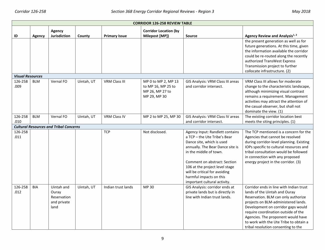
the present generation as well as for future generations. At this time, given the information available the corridor could be re-routed along the recently authorized TransWest Express Transmission project to further collocate infrastructure. (2)
Visual Resources 126-258 .009
BLM Vernal FO Uintah, UT VRM Class III MP 0 to MP 2, MP 13 to MP 16, MP 25 to MP 26, MP 27 to MP 29, MP 30
GIS Analysis: VRM Class III areas and corridor intersect.
VRM Class III allows for moderate change to the characteristic landscape, although minimizing visual contrast remains a requirement. Management activities may attract the attention of the casual observer, but shall not dominate the view. (1)
126-258 .010
BLM Vernal FO Uintah, UT VRM Class IV MP 2 to MP 25, MP 30 GIS Analysis: VRM Class IV areas and corridor intersect.
The existing corridor location best meets the siting principles. (1)
Cultural Resources and Tribal Concerns 126-258 .011
TCP Not disclosed. Agency Input: Randlett contains a TCP – the Ute Tribe’s Bear Dance site, which is used annually. The Bear Dance site is in the middle of town. Comment on abstract: Section 106 at the project level stage will be critical for avoiding harmful impacts on this important cultural activity.
The TCP mentioned is a concern for the Agencies that cannot be resolved during corridor-level planning. Existing IOPs specific to cultural resources and tribal consultation would be followed in connection with any proposed energy project in the corridor. (3)
126-258 .012
BIA Uintah and Ouray Reservation and private land
Uintah, UT Indian trust lands MP 30 GIS Analysis: corridor ends at private lands but is directly in line with Indian trust lands.
Corridor ends in line with Indian trust lands of the Uintah and Ouray Reservation. BLM can only authorize projects on BLM-administered lands. Development on corridor gaps would require coordination outside of the Agencies. The proponent would have to work with the Ute Tribe to obtain a tribal resolution consenting to the
Corridor 126-258 Section 368 Energy Corridor Regional Reviews - Region 3 May 2018
10
CORRIDOR 126-258 REVIEW TABLE
ID Agency Agency Jurisdiction
County Primary Issue
Corridor Location (by Milepost [MP]) Source Agency Review and Analysis1, 2
grant of a ROW by BIA. BIA cannot grant ROWs without tribal consent. (3)
126-258 .013
Uintah, UT Ute Tribe trust land Not specified. Agency Input: the majority of the corridor is within the exterior boundaries of the Reservation. The Ute Tribe is seeking those lands to be restored to them administratively.
The Ute Tribe land ownership lawsuit is pending early next year, which may affect the lower portion of this route. Re-routing the corridor along the recently authorized Transwest Express Transmission Project appears to avoid tribal lands. (3)
Land Use Concerns Corridor pinched by BLM or USFS authorized use 126-258 .014
BLM Vernal FO Uintah, UT Existing infrastructure
MP 10 Agency Input: existing oil and gas infrastructure around MP 10. This route was deliberately avoided by TransWest Express because it was too hard to weave through and maintain appropriate buffer distances.
It would be difficult to site additional energy transport infrastructure in the corridor at this location. There is an opportunity for the agencies to consider revising the corridor to follow the preferred route for TransWest Express north of Corridor 126-258 to avoid this area. (2)
126-258 .015
BLM Vernal FO Uintah, UT Cathodic protection due to existing infrastructure
Not specified. Agency Input: if power and pipelines are to be collocated, then cathodic protection of the pipelines will be necessary.
Cathodic protection of the pipelines as well as separation distances between the two will be necessary for collocation of power lines and pipelines. There is an existing project design IOP that requires designing the project to avoid accelerating the corrosion of the pipelines and/or pumping wells. (1)
Public Access and Recreation 126-258 .016
NA State land Uintah, UT Green River MP 24 to MP 25 Agency Input: Green River recreation.
Not a consideration for corridor-level planning. At the project-level, any new project would need to take recreation on the Green River into consideration. (3)
Other noted land use concerns 126-258 .017
NA Private lands UT Agricultural lands Not specified. Comment on abstract: energy development may have impact on agriculture in adjacent areas
Corridor-level planning does not entail the detail necessary to prescribe operation and maintenance procedures
Corridor 126-258 Section 368 Energy Corridor Regional Reviews - Region 3 May 2018
11
CORRIDOR 126-258 REVIEW TABLE
ID Agency Agency Jurisdiction
County Primary Issue
Corridor Location (by Milepost [MP]) Source Agency Review and Analysis1, 2
if not developed and maintained properly (e.g., invasive and noxious weed species). Ensure that all developments, changes, or alterations to energy corridors do not adversely affect agriculture and domestic livestock grazing in the affected areas.
on hypothetical projects or corridor revisions. The concern will be addressed with specific, current information at the time of energy development proposal(s) (3).
1 Projects proposed in the corridor would be reviewed during their ROW application review process and would adhere to Federal laws, regulations, and policy. 2 (1) = confirm existing corridor best meets siting principles; (2) = identify opportunities to improve corridor placement or IOPs; (3) = acknowledge concern not easily resolved or
avoided by corridor-level planning.
Abstract Acronyms and Abbreviations ARMPA = Approved Resource Management Plan Amendment; BIA= Bureau of Indian Affairs; BLM = Bureau of Land Management; ESA = Endangered Species Act; FO = Field Office; GHMA = General Habitat Management Area; GIS = geographic information system; GRSG = Greater Sage-grouse; IOP = interagency operating procedure; MP = milepost; NA = not applicable; NAAQS = National Ambient Air Quality Standards; NSO = no surface occupancy; PEIS = Programmatic Environmental Impact Statement; PFYC = Potential Fossil Yield Classification; RMP = Resource Management Plan; ROW = right-of-way; TCP = Traditional Cultural Property; USFS = U.S. Forest Service; USFWS = U.S. Fish and Wildlife Service; VRM = Visual Resource Management; WSA = Wilderness Study Area; WWEC = West-wide Energy Corridor.


![ajguwriwiswcui^^- ::::::::::ii{^ 198… · IJptpn George W 368-2i(u Walker Dennis N 36S-2]Q9 Watson Gordon BoxS2 .... . , 368-2473 Watson,dohnR i'., '368-22u Watts Clark 368-2469](https://img.pdfslide.us/doc/110x75/5f48a2995403983c750e8274/ajguwriwiswcui-ii-198-ijptpn-george-w-368-2iu-walker-dennis-n.jpg)