Embed Size (px)
Citation preview
Corridor 126-218 Section 368 Energy Corridor Regional Reviews - Region 3 May 2018
1
Corridor 126-218 Vernal to Rock Springs Corridor
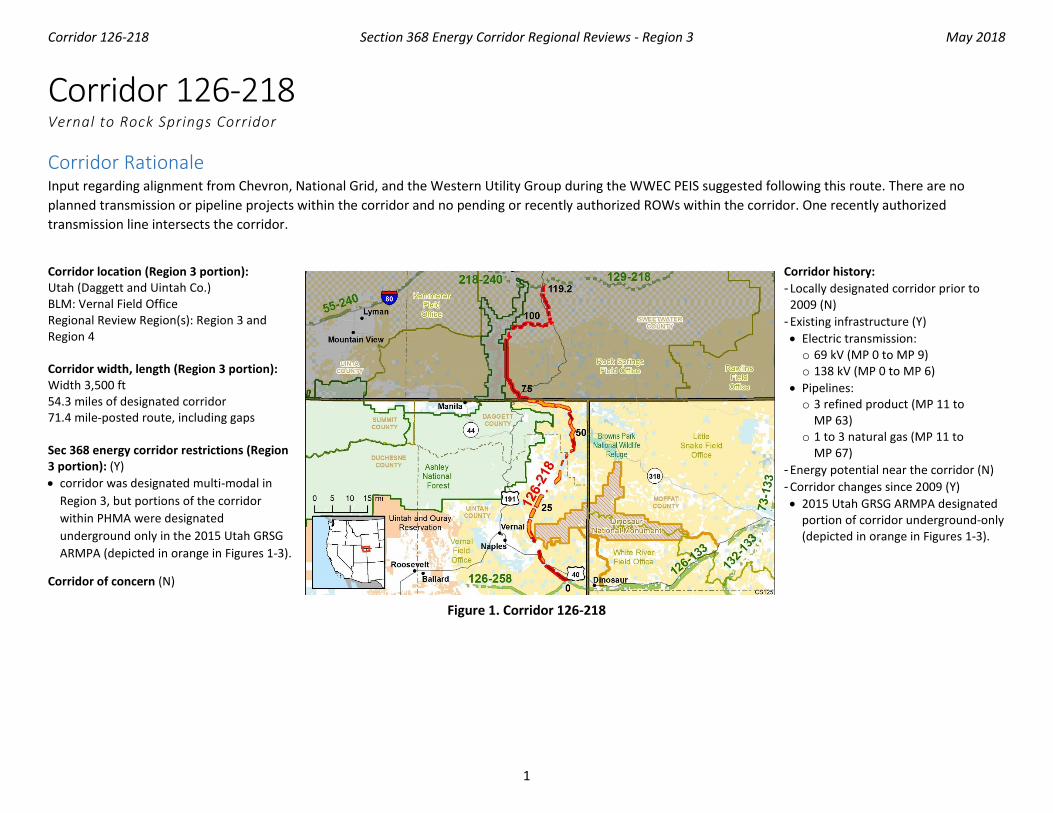
Corridor Rationale Input regarding alignment from Chevron, National Grid, and the Western Utility Group during the WWEC PEIS suggested following this route. There are no planned transmission or pipeline projects within the corridor and no pending or recently authorized ROWs within the corridor. One recently authorized transmission line intersects the corridor.
Corridor location (Region 3 portion): Utah (Daggett and Uintah Co.) BLM: Vernal Field Office Regional Review Region(s): Region 3 and Region 4 Corridor width, length (Region 3 portion): Width 3,500 ft 54.3 miles of designated corridor 71.4 mile-posted route, including gaps Sec 368 energy corridor restrictions (Region 3 portion): (Y) • corridor was designated multi-modal in
Region 3, but portions of the corridor within PHMA were designated underground only in the 2015 Utah GRSG ARMPA (depicted in orange in Figures 1-3).
Corridor of concern (N)
Corridor history: - Locally designated corridor prior to
2009 (N) - Existing infrastructure (Y) • Electric transmission: o 69 kV (MP 0 to MP 9) o 138 kV (MP 0 to MP 6)
• Pipelines: o 3 refined product (MP 11 to
MP 63) o 1 to 3 natural gas (MP 11 to
MP 67) - Energy potential near the corridor (N) - Corridor changes since 2009 (Y) • 2015 Utah GRSG ARMPA designated
portion of corridor underground-only (depicted in orange in Figures 1-3).
Figure 1. Corridor 126-218
Corridor 126-218 Section 368 Energy Corridor Regional Reviews - Region 3 May 2018
2
Keys for Figures 1 and 2
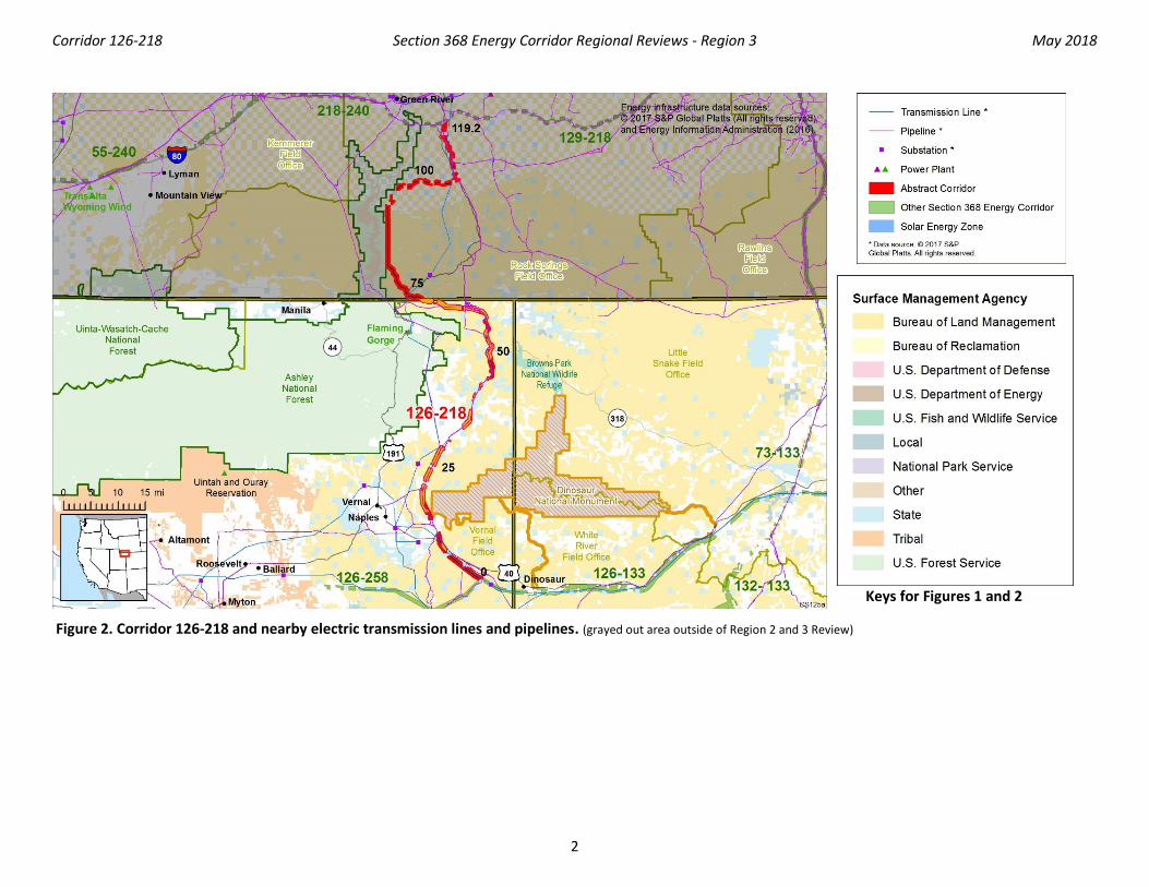
Figure 2. Corridor 126-218 and nearby electric transmission lines and pipelines . (grayed out area outside of Region 2 and 3 Review)
Corridor 126-218 Section 368 Energy Corridor Regional Reviews - Region 3 May 2018
3
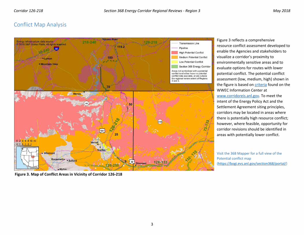
Conflict Map Analysis
Figure 3. Map of Conflict Areas in Vicinity of Corridor 126-218
Figure 3 reflects a comprehensive resource conflict assessment developed to enable the Agencies and stakeholders to visualize a corridor’s proximity to environmentally sensitive areas and to evaluate options for routes with lower potential conflict. The potential conflict assessment (low, medium, high) shown in the figure is based on criteria found on the WWEC Information Center at www.corridoreis.anl.gov. To meet the intent of the Energy Policy Act and the Settlement Agreement siting principles, corridors may be located in areas where there is potentially high resource conflict; however, where feasible, opportunity for corridor revisions should be identified in areas with potentially lower conflict.
Visit the 368 Mapper for a full view of the Potential conflict map (https://bogi.evs.anl.gov/section368/portal/)
Corridor 126-218 Section 368 Energy Corridor Regional Reviews - Region 3 May 2018
4
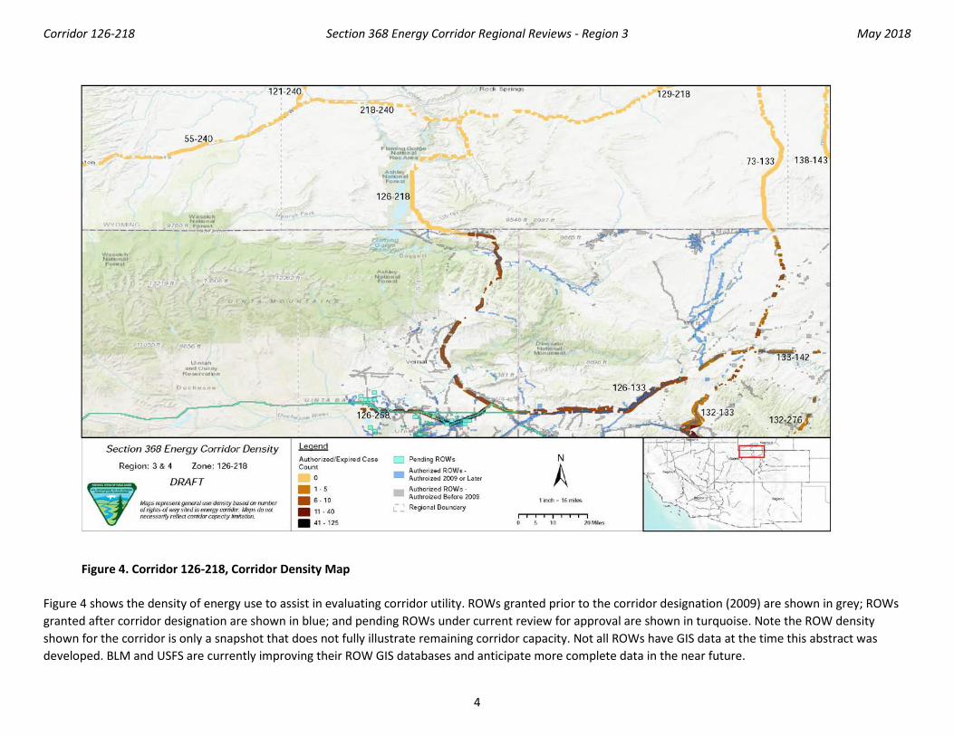
Figure 4. Corridor 126-218, Corridor Density Map
Figure 4 shows the density of energy use to assist in evaluating corridor utility. ROWs granted prior to the corridor designation (2009) are shown in grey; ROWs granted after corridor designation are shown in blue; and pending ROWs under current review for approval are shown in turquoise. Note the ROW density shown for the corridor is only a snapshot that does not fully illustrate remaining corridor capacity. Not all ROWs have GIS data at the time this abstract was developed. BLM and USFS are currently improving their ROW GIS databases and anticipate more complete data in the near future.
Corridor 126-218 Section 368 Energy Corridor Regional Reviews - Region 3 May 2018
5
General Stakeholder Feedback on Corridor Utility The State of Utah believes that the corridor plays an important role for existing and future energy infrastructure in the Uintah Basin, and requests that no changes are made to the existing alignment of the corridor. The State of Utah expressed that the corridor is particularly important due to its proximity to oil and gas developments that require quality transportation infrastructure.
Corridor Review Table The table below captures details of the Agencies’ review of the energy corridor. Consideration of the general corridor siting principles of the 2012 Settlement Agreement framed each corridor review, to identify potential improvements to maximize corridor utility and minimize impacts on the environment. Initial Agency analysis is provided to facilitate further discussion during stakeholder workshops.
CORRIDOR 126-218 REVIEW TABLE
ID Agency Agency Jurisdiction
County Primary Issue
Corridor Location (by Milepost [MP]) Source Agency Review and Analysis1, 2
ENVIRONMENTAL RESOURCE ISSUES Specially Designated Areas 126-218 .001
BLM Vernal FO Daggett, UT Diamond Breaks WSA MP 47 to MP 48 GIS Analysis: WSA over 1 mi east of corridor.
WSAs are an important resource that are considered carefully during corridor planning. The corridor’s current location does not intersect the WSA and best meets the siting principles. (1)
126-218 .002
BLM Vernal FO Daggett, UT Browns Park ACEC MP 49 to MP 57 GIS Analysis: ACEC intersects corridor.
The Browns Park ACEC is an avoidance area (NSO for leasing). The Vernal Approved RMP (2008) is consistent with decisions identified in the West-wide Energy Corridor PEIS ROD; the corridor meets the siting principles. There is no alternative route following a locally designated corridor or existing infrastructure with which the corridor could be collocated. Existing infrastructure already occurs within the corridor within the ACEC. (1)
126-218 .003
BLM Vernal FO Daggett, UT Red Creek ACEC MP 59 to MP 69 GIS Analysis: ACEC intersects corridor. Agency Input: Red Creek ACEC is being managed to reduce
The ACEC is a ROW avoidance area. The Vernal Approved RMP (2008) is consistent with decisions identified in the West-wide Energy Corridor PEIS ROD; the corridor meets the siting
Corridor 126-218 Section 368 Energy Corridor Regional Reviews - Region 3 May 2018
6
CORRIDOR 126-218 REVIEW TABLE
ID Agency Agency Jurisdiction
County Primary Issue
Corridor Location (by Milepost [MP]) Source Agency Review and Analysis1, 2
sedimentation into Red Creek and the downstream Green River by stabilizing channels and stream banks to lessen erosion and by maintaining vegetation cover through the watershed.
principles. There is no alternative route following a locally designated corridor or existing infrastructure with which the corridor could be collocated. Existing infrastructure already occurs within the corridor within the ACEC. (1)
126-218 .004
BLM Vernal FO Daggett, UT Upper Green River WSR
Not specified. Agency Input: suitable segment of the Upper Green River is tentatively classified as recreational. Suitable rivers are generally analyzed to ensure that actions do not impact their free-flowing condition, outstandingly remarkable values or tentative classification.
Suitable WSR ScenicRec-7 in RMP allows NSO (ROW avoidance) within line of sight up to 0.5 mi except in established corridors. (3)
126-218 .005
BLM Vernal FO Uintah and Daggett, UT
Blue Mountain SRMA MP 8 to MP 12, MP 49 to MP 57
GIS Analysis: SRMA intersects and is adjacent to corridor
There are existing pipelines within the corridor where it passes though the Blue Mountain SRMA. The preferred methodology to mitigate undue degradation of resources is to collocate future energy infrastructure across public land with existing infrastructure to the extent feasible As such, the current location appears to best meet the siting principles (1)
Ecology 126-218 .006
BLM Vernal FO Uintah, UT Hamilton Milkvetch (BLM sensitive species)
MP 25 Agency Input: habitat in corridor.
Not a consideration for corridor-level planning and would be addressed during the ROW application process. At the project-level, any new proposal would need to take sensitive species into consideration and consult as appropriate. IOPs would be followed to minimize impacts. (3)
126-218 .007
BLM Vernal FO Uintah and Daggett, UT
Ute Ladies’-tresses (ESA-listed: threatened)
MP 20, MP 50 Agency Input: habitat and known individuals. Potential habitat where there are riparian areas.
Protection of ESA-listed species habitat is important. The corridor location within the current range of habitat and known individuals of the Ute Ladies’-
Corridor 126-218 Section 368 Energy Corridor Regional Reviews - Region 3 May 2018
7
CORRIDOR 126-218 REVIEW TABLE
ID Agency Agency Jurisdiction
County Primary Issue
Corridor Location (by Milepost [MP]) Source Agency Review and Analysis1, 2
tresses is not easily resolved or avoided by corridor-level planning. Further analysis to determine the presence of the species occurring within the area will be considered outside of corridor-level planning. (3)
126-218 .008
BLM Vernal FO Uintah and Daggett, UT
GRSG (BLM and USFS sensitive species)
Not specified. RFI: substantially re-route this segment and follow overall recommendations for the following West-wide risk scores: "High" risk to Flowlines, "High" risk to Permeability, "Very High" risk to CHAT, and "High" risk to Imperiled Species. Re-route or exclude new infrastructure ROWs and avoid all new energy infrastructure development within GRSG PACs (62% overlap). Use full mitigation hierarchy to avoid, minimize, and compensate for impacts within four miles of important sage-grouse breeding areas. Identify and where present avoid impacts to geographic areas for recovery units for threatened and endangered species. Comment on abstract: Reroute to avoid GRSG PACs.
The corridor location within the current range of the GRSG is not easily resolved or avoided by corridor-level planning because alternate routes could still require siting through the habitat for this species. Further analysis to determine the presence of the species occurring within the area will be considered outside of corridor-level planning. (3) See also response below for GRSG PHMA and GHMA.
126-218 .009
BLM Vernal FO Rock Springs FO
Uintah and Daggett, UT Sweetwater, WY
Utah GRSG PHMA (BLM and USFS sensitive species)
MP 7 to MP 10, MP 16 to MP 46, MP 50 to MP 56, MP 58 to MP 119 MP 70 to MP 71
GIS Analysis: GRSG PHMA intersects corridor. GIS Analysis: GRSG GHMA is adjacent to corridor.
The Utah GRSG ARMPA retained the existing 368 corridor, but changed it to be available for underground use only in PHMAs; no new above-ground lines can be constructed in the PHMA portions of this corridor. Since the corridor overlaps one of the largest GRSG populations in the state, no new
Corridor 126-218 Section 368 Energy Corridor Regional Reviews - Region 3 May 2018
8
CORRIDOR 126-218 REVIEW TABLE
ID Agency Agency Jurisdiction
County Primary Issue
Corridor Location (by Milepost [MP]) Source Agency Review and Analysis1, 2
Nine Plan GRSG GHMA (BLM and USFS sensitive species)
aboveground ROWs can be built within the corridor. Within existing designated utility corridors, an exception to the 3 percent disturbance cap is provided in designated utility corridors for achieving a net conservation gain to the species. This exception is limited to projects that fulfill the use that the corridors were designated for (e.g., transmission lines and pipelines) and within the designated width of the corridor. This exception will concentrate future ROW surface disturbance in areas of existing disturbance and will avoid new development of infrastructure corridors in PHMAs. Given that the corridor is underground only to avoid PHMAs and future development in the corridor will collocate energy infrastructure across public land with existing infrastructure to the extent feasible, the current location appears to best meet the siting principles. (1)
126-218 .010
NA State Land Uintah, UT Colorado Pikeminnow critical habitat (ESA-listed: endangered) Razorback Sucker critical habitat (ESA-listed: endangered) Humpback Chub critical habitat (ESA-listed: endangered)
MP 12 to MP 15 RFI: consult with USFWS to avoid adverse modification to designated critical habitat. GIS Analysis: critical habitat intersects corridor gap.
Protection of ESA-listed species habitat is important. The preferred methodology to mitigate undue degradation of resources is to collocate future energy infrastructure across public land with existing infrastructure to the extent feasible. As such, the current location appears to best meet the siting principles based on the settlement agreement, since any alternative route would go through
Corridor 126-218 Section 368 Energy Corridor Regional Reviews - Region 3 May 2018
9
CORRIDOR 126-218 REVIEW TABLE
ID Agency Agency Jurisdiction
County Primary Issue
Corridor Location (by Milepost [MP]) Source Agency Review and Analysis1, 2
Bonytail Chub critical habitat (ESA-listed: endangered)
areas of ESA-listed critical habitat and would not lend-itself to collocation and would further fragment critical habitat. (1)
126-218 .011
Special status species Not specified. Comment on abstract: threatened and endangered species that may occur along this corridor include Black-footed Ferret, Mexican Spotted Owl, Western Yellow-billed Cuckoo, Colorado River fishes (Bonytail Chub, Colorado Pikeminnow, Humpback Chub, and Razorback Sucker), and Ute Ladies’-tresses. Colorado River fishes may be impacted by direct impacts from stream crossings and water depletions. Projects taking place in this corridor may require ESA Section 7 consultation with the USFWS. We recommend that projects within this corridor are evaluated for impacts to listed species and their habitats, and measures are included to avoid, minimize, and mitigate impacts. Comment on abstract: Additional species not identified in the corridor abstract may be present: Canada Lynx, Mexican Spotted Owl, Western Yellow-billed Cuckoo, and Ute Ladies'-tresses. Conduct further analysis to determine the presence of abovementioned species.
This corridor location within the current range where these species may occur is not easily resolved or avoided by corridor-level planning because alternate routes would still require siting through the current range of these species, Further analysis to determine the presence of all species occurring within the area will be considered outside the corridor-level planning. (3)
Corridor 126-218 Section 368 Energy Corridor Regional Reviews - Region 3 May 2018
10
CORRIDOR 126-218 REVIEW TABLE
ID Agency Agency Jurisdiction
County Primary Issue
Corridor Location (by Milepost [MP]) Source Agency Review and Analysis1, 2
Air Quality 126-218 .012
EPA EPA Uintah, UT Air Quality MP 0 to MP 44 Agency Input: Uintah County is pending non-attainment designation for the ozone NAAQS.
Not a consideration for corridor-level planning. At the project-level, any new project would need to take non-attainment into consideration. IOPs would be followed to minimize fugitive dust generation. (3)
Paleontology 126-218 .013
BLM Vernal FO Uintah and Daggett, UT
PFYC Class 4 PFYC Class 5
MP 0 to MP 4, MP 49 to MP 56, MP 59 to MP 60, MP 65 to MP 71 MP 1 to MP 2, MP 3, MP 5 to MP 10, MP 11 to MP 12, MP 16 to MP 17, MP 18, and MP 19 to MP 21
GIS Analysis: PFYC Class 4 and 5 areas intersect corridor. Agency Input: the section of the corridor just west of the boundary of Dinosaur National Monument is in the Morrison Formation (Jurassic) with PFYC of 5 and there are multiple known localities in this area so very sensitive. The corridor crosses through the Cedar Mountain Formation (Cretaceous) which has fossil vertebrates, as does the Dakota Formation. The corridor crosses the Mancos and Mowry Shale (Cretaceous) which may have marine vertebrates PFYC 3. The route also crosses Pleistocene sediments which have the potential for scattered vertebrate remains.
The identified potential of paleontological resources is a concern for the Agencies, which cannot be resolved during corridor-level planning. Assessments will occur as part of the ROW application process. (3)
Lands with Wilderness Characteristics 126-218 .014
BLM Vernal FO Uintah and Daggett, UT
Lands with wilderness characteristics
MP 0 to MP 7, MP 8 to MP 10, MP 15 to MP 29, MP 35 to MP 39, MP 41 to
RFI: Cold Spring Mountain, The Rim Rock GIS Analysis: lands with wilderness characteristics
Corridor 126-218 intersects the Cold Spring Mountain, Lower Flaming Gorge, Dead Horse Pass, and Mountain Home lands with wilderness characteristics units. These units were
Corridor 126-218 Section 368 Energy Corridor Regional Reviews - Region 3 May 2018
11
CORRIDOR 126-218 REVIEW TABLE
ID Agency Agency Jurisdiction
County Primary Issue
Corridor Location (by Milepost [MP]) Source Agency Review and Analysis1, 2 MP 51, MP 52 to MP 68.
intersect and are adjacent to corridor. Agency Input: Rim Rock B, Cold Spring Mountain, Lower Flaming Gorge, Dead Horse Pass, Mountain Home. Comment on abstract: it is unclear whether the intersection with lands with wilderness characteristics will be addressed through the Regional Review. The Agencies must use a consistent approach that makes clear commitments to addressing intersections with ACECs and other special designations and provides details on opportunities to do so through corridor revisions.
designated as natural areas in the 2008 Vernal RMP, are managed to maintain their wilderness character, and are considered avoidance areas for ROWs. Vernal RMP determined that Rim Rock B is not designated as a natural area and will not be managed to preserve wilderness characteristics. The BLM retains broad discretion regarding the multiple use management of lands possessing wilderness characteristics without Wilderness or WSA designations. As such, land possessing the characteristics of wilderness are not subject to the legal thresholds or other statutory obligations specified for congressionally designated Wilderness and WSAs. There are necessities that warrant land use and thus rationalize energy corridors as meeting the best siting principles, which include maximizing utility while minimizing impacts. In locations where the BLM is not managing lands with wilderness characteristics with protective allocations, project level planning will still consider ways to minimize or avoid impacts while meeting the purpose and need of various types of land use including energy projects. Furthermore, the impairment of wilderness characteristics does not, in and of itself, constitute a significant impact; or on its own, warrant the relocation of a corridor or corridor segment. BLM must consider all resources and resource uses and
Corridor 126-218 Section 368 Energy Corridor Regional Reviews - Region 3 May 2018
12
CORRIDOR 126-218 REVIEW TABLE
ID Agency Agency Jurisdiction
County Primary Issue
Corridor Location (by Milepost [MP]) Source Agency Review and Analysis1, 2
carefully weigh the current value for the present generation as well as for future generations. At this time, given the information available, there is an opportunity for the Agencies to consider adding an IOP related to lands with wilderness characteristics to ensure appropriate consideration occurs with proposed development within the energy corridor. (2)
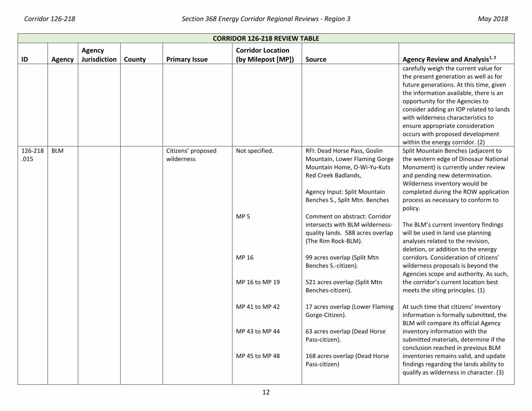
126-218 .015
BLM Citizens’ proposed wilderness
Not specified. MP 5 MP 16 MP 16 to MP 19 MP 41 to MP 42 MP 43 to MP 44 MP 45 to MP 48
RFI: Dead Horse Pass, Goslin Mountain, Lower Flaming Gorge Mountain Home, O-Wi-Yu-Kuts Red Creek Badlands, Agency Input: Split Mountain Benches S., Split Mtn. Benches Comment on abstract: Corridor intersects with BLM wilderness-quality lands. 588 acres overlap (The Rim Rock-BLM). 99 acres overlap (Split Mtn Benches S.-citizen). 521 acres overlap (Split Mtn Benches-citizen). 17 acres overlap (Lower Flaming Gorge-Citizen). 63 acres overlap (Dead Horse Pass-citizen). 168 acres overlap (Dead Horse Pass-citizen)
Split Mountain Benches (adjacent to the western edge of Dinosaur National Monument) is currently under review and pending new determination. Wilderness inventory would be completed during the ROW application process as necessary to conform to policy. The BLM’s current inventory findings will be used in land use planning analyses related to the revision, deletion, or addition to the energy corridors. Consideration of citizens’ wilderness proposals is beyond the Agencies scope and authority. As such, the corridor’s current location best meets the siting principles. (1) At such time that citizens’ inventory information is formally submitted, the BLM will compare its official Agency inventory information with the submitted materials, determine if the conclusion reached in previous BLM inventories remains valid, and update findings regarding the lands ability to qualify as wilderness in character. (3)
Corridor 126-218 Section 368 Energy Corridor Regional Reviews - Region 3 May 2018
13
CORRIDOR 126-218 REVIEW TABLE
ID Agency Agency Jurisdiction
County Primary Issue
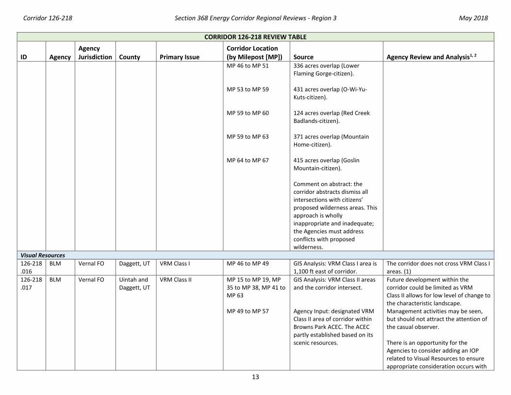
Corridor Location (by Milepost [MP]) Source Agency Review and Analysis1, 2 MP 46 to MP 51 MP 53 to MP 59 MP 59 to MP 60 MP 59 to MP 63 MP 64 to MP 67
336 acres overlap (Lower Flaming Gorge-citizen). 431 acres overlap (O-Wi-Yu-Kuts-citizen). 124 acres overlap (Red Creek Badlands-citizen). 371 acres overlap (Mountain Home-citizen). 415 acres overlap (Goslin Mountain-citizen). Comment on abstract: the corridor abstracts dismiss all intersections with citizens’ proposed wilderness areas. This approach is wholly inappropriate and inadequate; the Agencies must address conflicts with proposed wilderness.
Visual Resources 126-218 .016
BLM Vernal FO Daggett, UT VRM Class I MP 46 to MP 49 GIS Analysis: VRM Class I area is 1,100 ft east of corridor.
The corridor does not cross VRM Class I areas. (1)
126-218 .017
BLM Vernal FO Uintah and Daggett, UT
VRM Class II MP 15 to MP 19, MP 35 to MP 38, MP 41 to MP 63 MP 49 to MP 57
GIS Analysis: VRM Class II areas and the corridor intersect. Agency Input: designated VRM Class II area of corridor within Browns Park ACEC. The ACEC partly established based on its scenic resources.
Future development within the corridor could be limited as VRM Class II allows for low level of change to the characteristic landscape. Management activities may be seen, but should not attract the attention of the casual observer. There is an opportunity for the Agencies to consider adding an IOP related to Visual Resources to ensure appropriate consideration occurs with

Corridor 126-218 Section 368 Energy Corridor Regional Reviews - Region 3 May 2018
14
CORRIDOR 126-218 REVIEW TABLE
ID Agency Agency Jurisdiction
County Primary Issue
Corridor Location (by Milepost [MP]) Source Agency Review and Analysis1, 2
proposed development within the energy corridor. (2)
126-218 .018
BLM Vernal FO, Rock Springs FO
Uintah and Daggett, UT and Sweetwater, WY
VRM Class III MP 0 to MP 2, MP 6, MP 15, MP 18 to MP 32, MP 59 to MP 71 MP 59 to MP 63, MP 64 to MP 69
GIS Analysis: VRM Class III areas intersect the corridor. Agency Input: Designated VRM Class III and Class IV areas of corridor within Red Creek ACEC. The ACEC partly established based on its scenic resources. Also Browns Park area.
VRM Class III allows for moderate change to the characteristic landscape, although minimizing visual contrast remains a requirement. Management activities may attract the attention of the casual observer, but shall not dominate the view. (1)
126-218 .019
BLM Vernal FO Uintah, UT VRM Class IV MP 2 to MP 15, MP 38 to MP 42, MP 59 to MP 66
GIS Analysis: VRM Class IV areas and the corridor intersect.
The existing corridor location best meets the siting principles. (1)
Cultural Resources 126-218 .020
NA State land Daggett, UT Dr. John Parson Cabin Complex
MP 51 GIS Analysis: site listed on the NRHP is adjacent to corridor.
This site could potentially be impacted by presence of additional development. NHPA Section 106 process would be followed to identify any possible impact of development. Existing IOPs specific to cultural resources would be followed in connection with any proposed energy project in the corridor and that may also potentially affect listed properties in corridor gaps or near the corridor. (3)
126-218 .021
BLM Vernal FO Daggett, UT John Jarvie Historic Ranch District
MP 55 GIS Analysis: site listed on NRHP over 1 mi west of corridor.
The property is not within the corridor and are not a consideration for corridor-level planning. Section 106 process would be followed to identify possible impact of development. (1)
126-218 .022
BLM Vernal FO Daggett, UT Class III survey work Not specified. Agency Input: Class III survey work from RMP Settlement Agreement including Browns Park ACEC and other high probability areas.
The potential for cultural resources is a concern for the Agencies that cannot be resolved during corridor-level planning. Section 106 consultation will
Corridor 126-218 Section 368 Energy Corridor Regional Reviews - Region 3 May 2018
15
CORRIDOR 126-218 REVIEW TABLE
ID Agency Agency Jurisdiction
County Primary Issue
Corridor Location (by Milepost [MP]) Source Agency Review and Analysis1, 2
occur as part of the ROW application process. (3)
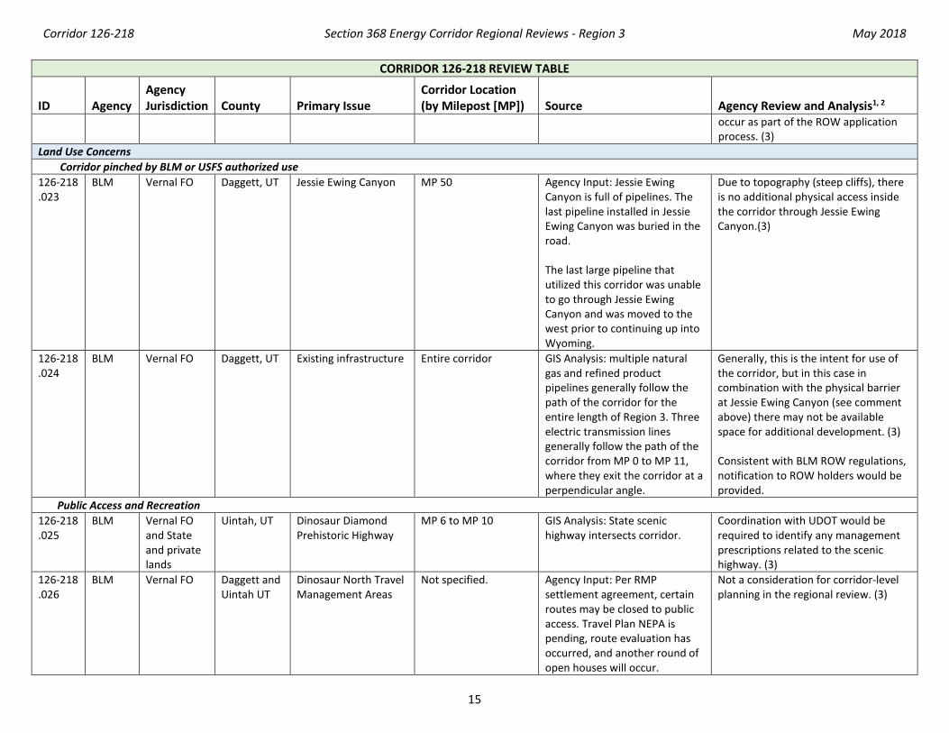
Land Use Concerns Corridor pinched by BLM or USFS authorized use 126-218 .023
BLM Vernal FO Daggett, UT Jessie Ewing Canyon MP 50 Agency Input: Jessie Ewing Canyon is full of pipelines. The last pipeline installed in Jessie Ewing Canyon was buried in the road. The last large pipeline that utilized this corridor was unable to go through Jessie Ewing Canyon and was moved to the west prior to continuing up into Wyoming.
Due to topography (steep cliffs), there is no additional physical access inside the corridor through Jessie Ewing Canyon.(3)
126-218 .024
BLM Vernal FO Daggett, UT Existing infrastructure Entire corridor GIS Analysis: multiple natural gas and refined product pipelines generally follow the path of the corridor for the entire length of Region 3. Three electric transmission lines generally follow the path of the corridor from MP 0 to MP 11, where they exit the corridor at a perpendicular angle.
Generally, this is the intent for use of the corridor, but in this case in combination with the physical barrier at Jessie Ewing Canyon (see comment above) there may not be available space for additional development. (3) Consistent with BLM ROW regulations, notification to ROW holders would be provided.
Public Access and Recreation 126-218 .025
BLM Vernal FO and State and private lands
Uintah, UT Dinosaur Diamond Prehistoric Highway
MP 6 to MP 10 GIS Analysis: State scenic highway intersects corridor.
Coordination with UDOT would be required to identify any management prescriptions related to the scenic highway. (3)
126-218 .026
BLM Vernal FO Daggett and Uintah UT
Dinosaur North Travel Management Areas
Not specified. Agency Input: Per RMP settlement agreement, certain routes may be closed to public access. Travel Plan NEPA is pending, route evaluation has occurred, and another round of open houses will occur.
Not a consideration for corridor-level planning in the regional review. (3)
Corridor 126-218 Section 368 Energy Corridor Regional Reviews - Region 3 May 2018
16
CORRIDOR 126-218 REVIEW TABLE
ID Agency Agency Jurisdiction
County Primary Issue
Corridor Location (by Milepost [MP]) Source Agency Review and Analysis1, 2
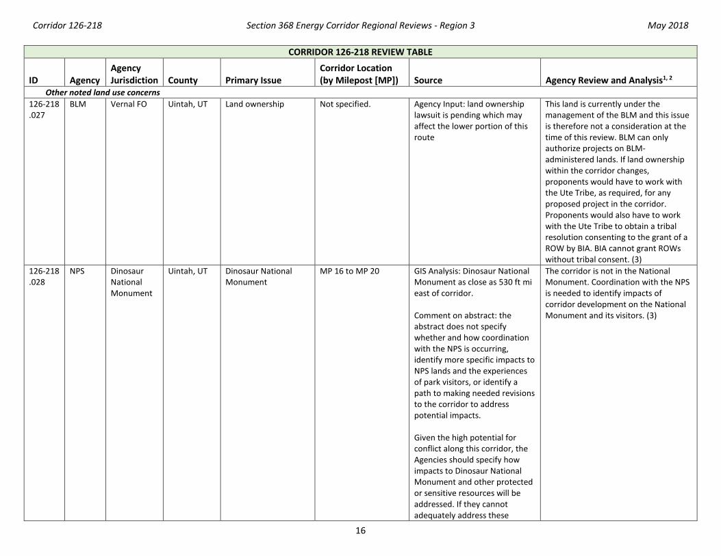
Other noted land use concerns 126-218 .027
BLM Vernal FO Uintah, UT Land ownership Not specified. Agency Input: land ownership lawsuit is pending which may affect the lower portion of this route
This land is currently under the management of the BLM and this issue is therefore not a consideration at the time of this review. BLM can only authorize projects on BLM-administered lands. If land ownership within the corridor changes, proponents would have to work with the Ute Tribe, as required, for any proposed project in the corridor. Proponents would also have to work with the Ute Tribe to obtain a tribal resolution consenting to the grant of a ROW by BIA. BIA cannot grant ROWs without tribal consent. (3)
126-218 .028
NPS Dinosaur National Monument
Uintah, UT Dinosaur National Monument
MP 16 to MP 20 GIS Analysis: Dinosaur National Monument as close as 530 ft mi east of corridor. Comment on abstract: the abstract does not specify whether and how coordination with the NPS is occurring, identify more specific impacts to NPS lands and the experiences of park visitors, or identify a path to making needed revisions to the corridor to address potential impacts. Given the high potential for conflict along this corridor, the Agencies should specify how impacts to Dinosaur National Monument and other protected or sensitive resources will be addressed. If they cannot adequately address these
The corridor is not in the National Monument. Coordination with the NPS is needed to identify impacts of corridor development on the National Monument and its visitors. (3)
Corridor 126-218 Section 368 Energy Corridor Regional Reviews - Region 3 May 2018
17
CORRIDOR 126-218 REVIEW TABLE
ID Agency Agency Jurisdiction
County Primary Issue
Corridor Location (by Milepost [MP]) Source Agency Review and Analysis1, 2
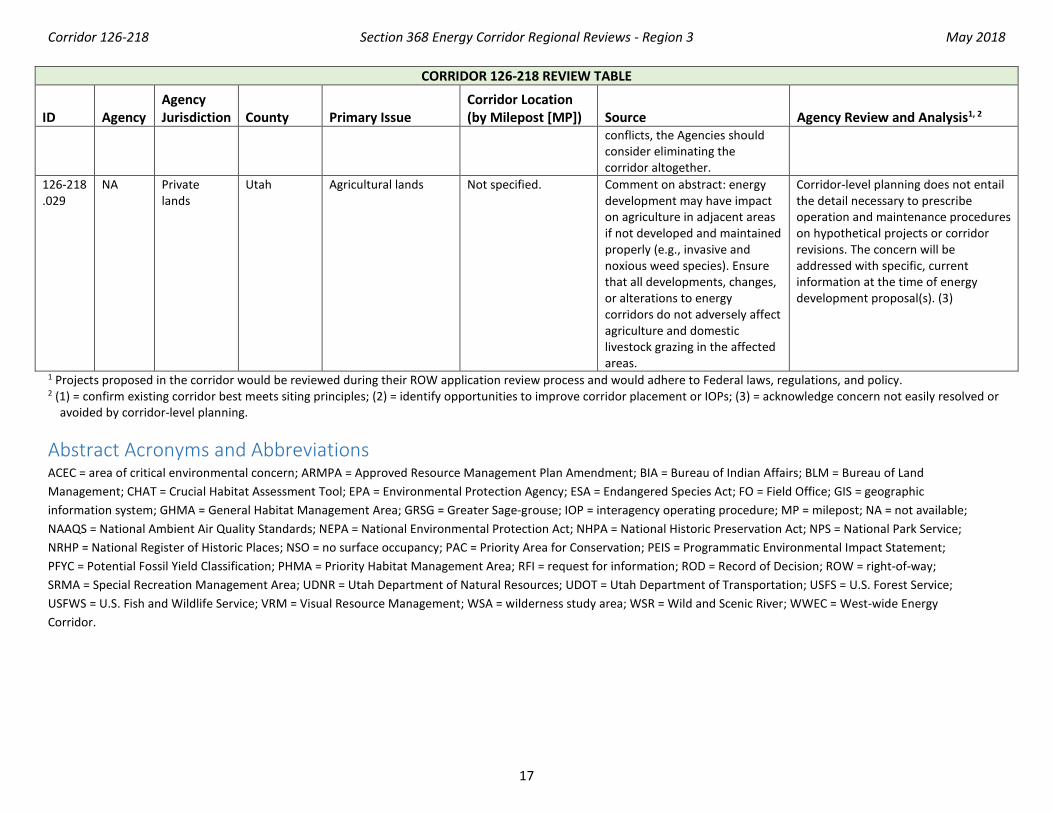
conflicts, the Agencies should consider eliminating the corridor altogether.
126-218 .029
NA Private lands
Utah Agricultural lands Not specified. Comment on abstract: energy development may have impact on agriculture in adjacent areas if not developed and maintained properly (e.g., invasive and noxious weed species). Ensure that all developments, changes, or alterations to energy corridors do not adversely affect agriculture and domestic livestock grazing in the affected areas.
Corridor-level planning does not entail the detail necessary to prescribe operation and maintenance procedures on hypothetical projects or corridor revisions. The concern will be addressed with specific, current information at the time of energy development proposal(s). (3)
1 Projects proposed in the corridor would be reviewed during their ROW application review process and would adhere to Federal laws, regulations, and policy. 2 (1) = confirm existing corridor best meets siting principles; (2) = identify opportunities to improve corridor placement or IOPs; (3) = acknowledge concern not easily resolved or
avoided by corridor-level planning.
Abstract Acronyms and Abbreviations ACEC = area of critical environmental concern; ARMPA = Approved Resource Management Plan Amendment; BIA = Bureau of Indian Affairs; BLM = Bureau of Land Management; CHAT = Crucial Habitat Assessment Tool; EPA = Environmental Protection Agency; ESA = Endangered Species Act; FO = Field Office; GIS = geographic information system; GHMA = General Habitat Management Area; GRSG = Greater Sage-grouse; IOP = interagency operating procedure; MP = milepost; NA = not available; NAAQS = National Ambient Air Quality Standards; NEPA = National Environmental Protection Act; NHPA = National Historic Preservation Act; NPS = National Park Service; NRHP = National Register of Historic Places; NSO = no surface occupancy; PAC = Priority Area for Conservation; PEIS = Programmatic Environmental Impact Statement; PFYC = Potential Fossil Yield Classification; PHMA = Priority Habitat Management Area; RFI = request for information; ROD = Record of Decision; ROW = right-of-way; SRMA = Special Recreation Management Area; UDNR = Utah Department of Natural Resources; UDOT = Utah Department of Transportation; USFS = U.S. Forest Service; USFWS = U.S. Fish and Wildlife Service; VRM = Visual Resource Management; WSA = wilderness study area; WSR = Wild and Scenic River; WWEC = West-wide Energy Corridor.