Embed Size (px)
Citation preview

CORPORATE REPORT
NO: R029 COUNCIL DATE: February 19, 2018
REGULAR COUNCIL
TO: Mayor & Council DATE: February 15, 2018
FROM: General Manager, Engineering General Manager, Parks, Recreation & Culture
FILE: XC:
0870-20/453A 0910-20/442A
SUBJECT: Acquisition of Portion of Privately-Owned Property at 6577 - 142 Street and Disposition of Portions of City Park Property at 14102 - 66 Avenue
RECOMMENDATION
The Engineering Department and the Parks, Recreation & Culture Department recommend that Council:
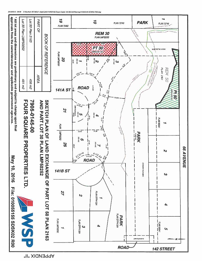
1. Approve the acquisition of a 438 m² (4,715 ft.²) portion of the privately-owned propertylocated at 6577 - 142 Street (PID: 002-293-064) for parkland purposes; and
2. Approve the disposition of a 481 m² (5,177 ft.²) portion of the City park property located at14102 - 66 Avenue (PID: 025-068-270) for consolidation and subdivision with theprivately-owned property at 6577 - 142 Street, subject to compliance with the notice provisionsunder Section 26 and 94 of the Community Charter, SBC, 2003, chap 26;
both as generally described in this report, and as illustrated in Appendix “I”.
BACKGROUND
Property Description
The privately-owned development property located at 6577 - 142 Street (the “Developer’s Property”) is an irregular shaped parcel of 9,884 m² (106,390 ft.²) in site area, which is improved with an older residence planned for demolition.
The City park property located at 14102 - 66 Avenue (the “City Property”) is a long, irregular shaped parcel of 2,844 m² (30,611 ft.²) in site area. It is in a natural state with underbrush and trees and is maintained by the City as a passive greenway corridor. It is fully encumbered by a B.C. Hydro transmission corridor. The City Property was transferred to the City as the legislated5% parkland requirement for a subdivision that was approved in 2001.
Hyland Creek, a Class “A” classified watercourse and a green infrastructure network corridor traverse both the Developer’s Property and the City Property in an east-west direction.

- 2 - Zoning, Plan Designations, and Land Uses Both the Developer’s Property and the City Property are zoned Single Family Residential (“RF”) Zone and designated Urban in Surrey’s Official Community Plan. In the South Newton Neighbourhood Concept Plan, the Developer’s Property is designated both “Creek and Riparian Setbacks” and “Single Family Small Lots” and the City Property is designated “Existing and Future Parks”. DISCUSSION Reason for the Acquisition and Disposition The 438 m² (4,715 ft.²) area of the Developer’s Property (the “Acquisition Area”) proposed to be purchased by the City will be in conjunction with Development Application No. 7905-0145-00. This Application contemplates the development of seven small single family lots, as illustrated on the attached Appendix “II”. The Acquisition Area is located outside and on the north side of the protected riparian area. In contrast, the proposed seven lots of Application No. 7905-0145-00 are located on the south side of the riparian area. The riparian land will be conveyed to the City without compensation as a requirement to the City approving Application No. 7905-0145-00 and will be maintained within Parks’ inventory of lands. The Parks Department is supportive of acquiring the Acquisition Area for addition to the riparian land and expansion of the existing adjacent parklands. The 481 m² (5,177 ft.²) area of the Park Property (the “Disposition Area”) to be sold is a protrusion from the generally long rectangular shaped corridor City Property. The Disposition Area is fully encumbered by the BC Hydro transmission corridor. It will contribute to the creation of Lots 1, 2, and 3 of the seven lot subdivision under Application No. 7905-0145-00. The Parks, Recreation & Culture Department has deemed the Disposition Area surplus to its requirements. The proposed acquisition and disposition of lands were referenced in the November 28, 2011 Planning Report to Council related to Application No. 7905-0145-00, and the related Rezoning Bylaw was granted third reading by Council on December 12, 2011. As part of the disposition process, staff will ensure that notice of the City land sale is issued in accordance with the provisions of Section 26 and 94 of the Community Charter, SBC, 2003, chap. 26.
Land Value The Acquisition Area and the Disposition Area will be transacted at their market values as determined by a qualified independent appraiser. The City will receive payment of the net difference between the acquisition value and disposition value of the lands, which will be placed in the Parklands Acquisition Reserve Fund for use in funding future purchases of parklands within the City.

- 3 - SUSTAINABILITY CONSIDERATIONS The proposed acquisition and disposition of lands supports the objectives of the City’s Sustainability Charter. In particular, the proposals relate to the Sustainability Charter themes of Built Environment and Neighbourhoods and Ecosystems and Infrastructure. Specifically, the land transactions support the following Strategic Directions and Desired Outcome:
• Neighbourhoods and Urban Design DO5: Trees, green spaces and natural areas are integrated into all neighbourhoods;
• Neighbourhoods and Urban Design DO8: The built environment enhances quality of life, happiness and well-being;
• Neighbourhoods and Urban Design SD3: Integrate natural areas, ecosystems and green areas in all neighbourhoods; and
• All Infrastructure DO4: Ecosystems and natural assets are an essential part of the community’s infrastructure system.
CONCLUSION The terms and conditions that have been negotiated for the proposed purchase of the Acquisition Area and simultaneous sale of the Disposition Area are considered reasonable. It is recommended that Council:
• Approve the acquisition of a 438 m² (4,715 ft.²) portion of the privately-owned property located at 6577 - 142 Street (PID: 002-293-064) for parkland purposes; and
• Approve the disposition of a 481 m² (5,177 ft.²) portion of the City property located at 14102 -
66 Avenue (PID: 025-068-270) for consolidation and subdivision with the privately-owned property at 6577 - 142 Street, subject to compliance with the notice provisions under Section 26 and 94 of the Community Charter, SBC, 2003, chap 26;
both as generally illustrated in Appendix “I” attached to this report.
Fraser Smith, P.Eng., MBA Laurie Cavan General Manager General Manager Engineering Parks Recreation & Culture AW/amg/ggg Appendix “I” - Aerial Photograph of Subject Site Appendix “II” - Preliminary Subdivision Plan for Development Application No. 7905-0145-00 g:\wp-docs\2018\admin\cr\01181500-aw.docx GG 2/15/18 4:03 PM

14050
14060
14088
6433
14158
6510
14166
14170
6538
6568
14182
14198
6633
14186
6533
6576
14040
14045
14063
6462
14067
14079
14090
14107
6469
6617
6436
6488
6530141
63141
52141
79141
78
6441
6481
64866478
14210
6636
14051
14035
14049
14057
14083
14099
14092
6656
6439
6539
66276577
6468 6476
14153
14136
14162
14178
14170
6471
6559
14221
6580
14030
6465
14039
14068
14084
14085
14077
14076
14076
14094
14102
6461
6483
14114 141
26
6525
14189
6556
14166
14192
6444
6558
14225
14032
14031
14071
14069
14093
14084
6429
6445
6477
6527
6629
14183
6574
6522
6464
6498
6664
14219
14041
6491
6511
14122
6430
6458
14162
6619
14160
14171
14190
14181
14212
6626
14222
6525
14029
14044
14062
14060
14070
14088
14096
6457 6453
6631
6446
6520 6519
6533
14144
14168
14174
14176
6612
6620
14158
14184
14188
6518
6449
6495
6565
14208
6532
14213
14216
14046
14052
14059
6440
14092
6432
6505
6623
6630
6621
6628
6437
6497
6521
6545
6615
6625
6639
6520
6620
6652
6517
14222
Hyland Crk
142 S
t
65 Ave
141A
St
66A Ave
64A Ave
66 Ave
140A St
141B
St
141A
St
66 Ave
65 Ave
141B
StTom Thumb Crk
Hyland Crk
ENGINEERINGDEPARTMENT
SUBJECT PROPERTIES6577 - 142 Street and 14102 - 66 Avenue
Source:G:\MAPPING\GIS\Maps\CorporateReps\Realty\JJR_6577_142 StAnd14102_66Ave_AP.mxd
The data provided is compiled from various sources and IS NOT warranted as to its accuracy or sufficiency by the City of Surrey.This information is provided for information and convenience purposes only.Lot sizes, Legal descriptions and encumbrances must be confirmed at the Land Title Office.
.
LEGENDSubject Properties 6577-142 St and 14102-66 AveAcquisition and Disposition Area7905-0145-00 Dev. Application Proposed LotsLots to be createdProtected Streamside AreaParksHydro Transmission LinesCreeks
APPENDIX "I"
Acquisition Area438 m² (±4,715 ft²)
LOCA
TION
^
Produced by GIS Section: 23-Jan-2018, JJR
Development Application7905-0145-00
Date of Aerial Photograph: April 2017 1:2,000Scale: 0 20 M
AERIAL PHOTOGRAPH OF SITE
City Property14102-66 Ave
Developer's Property6577-142 St
Disposition Area481 m² (±5,177 ft²)
APPENDIX "II"