Embed Size (px)
Citation preview
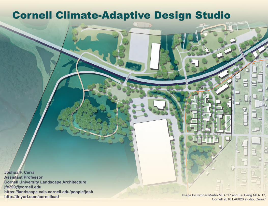
Cornell Climate-Adaptive Design Studio
Joshua F. CerraAssistant ProfessorCornell University Landscape [email protected]://landscape.cals.cornell.edu/people/joshhttp://tinyurl.com/cornellcad Image by Kimber Martin MLA ‘17 and Fei Peng MLA ‘17,
Cornell 2016 LA6020 studio, Cerra.”
W
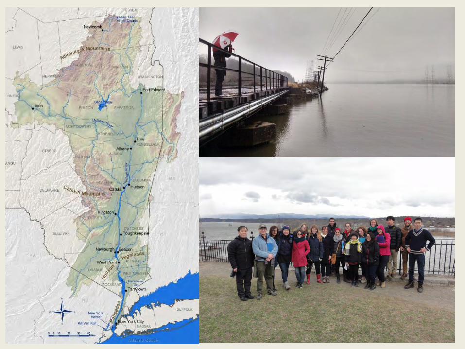
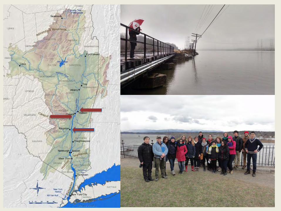
Building Capacity for Climate Adaptation One New York Municipality at a Time
This program links an academic design studio with New York State waterfront communities to explore alternatives for more resilient and connected waterfront areas.
It combines urban initiatives for growth and revitalization with the most recent climate projection science, as an opportunity not to fear change but to inspire cities to thrive by acting now.
In addition to physically adaptive design ideas, the process encourages stakeholder interaction and capacity-building at all levels in the interests of a more socially and ecologically resilient future.
This material is based upon work that is supported by the National Institute of Food and Agriculture, U.S. Department of Agriculture, under Smith Lever project number 2015-16-210 Any opinions, findings, conclusions, or recommendations expressed in this publication are those of the author(s) and do not necessarily reflect the view of the U.S. Department of Agriculture.
This report was prepared for the New York State Water Resources Institute (WRI) and the Hudson River Estuary program of the New York State Department of Environmental Conservation, with support from the NYS Environmental Protection Fund
Photos by Libby Zemaitis
W
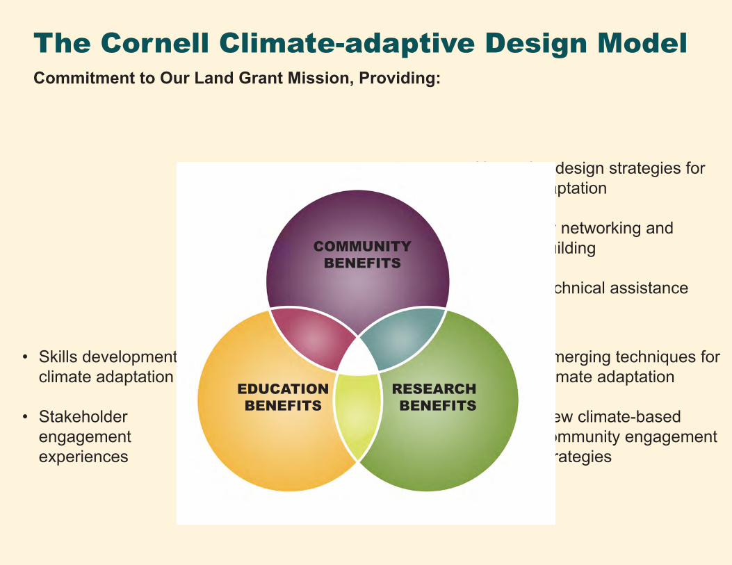
The Cornell Climate-adaptive Design ModelCommitment to Our Land Grant Mission, Providing:
• Alternative design strategies for climate adaptation
• Community networking and capacity-building
• Ongoing technical assistance
• Emerging techniques for climate adaptation
• New climate-based community engagement strategies
• Skills development in climate adaptation
• Stakeholder engagement experiences
COMMUNITY BENEFITS
EDUCATION BENEFITS
RESEARCH BENEFITS
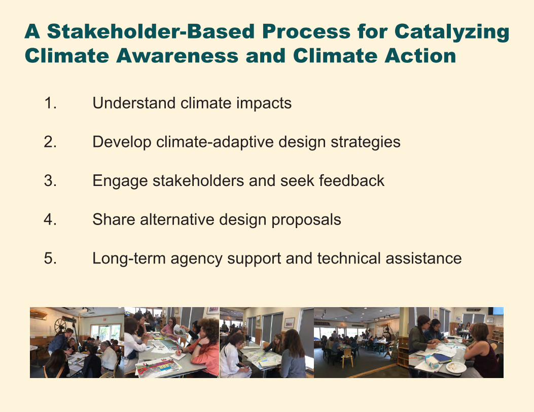
A Stakeholder-Based Process for Catalyzing Climate Awareness and Climate Action
1. Understand climate impacts
2. Develop climate-adaptive design strategies
3. Engage stakeholders and seek feedback
4. Share alternative design proposals
5. Long-term agency support and technical assistance
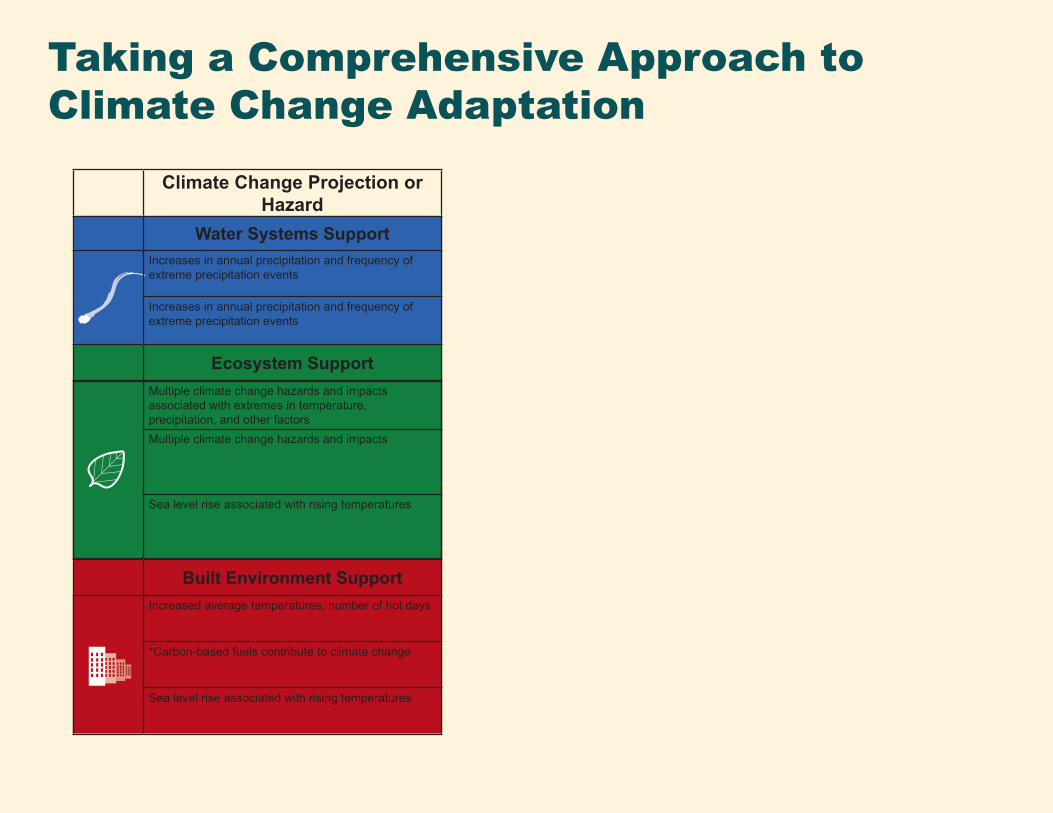
Taking a Comprehensive Approach to Climate Change Adaptation
Climate Change Projection or Hazard
Water Systems SupportIncreases in annual precipitation and frequency of extreme precipitation events
Increases in annual precipitation and frequency of extreme precipitation events
Ecosystem SupportMultiple climate change hazards and impacts associated with extremes in temperature, precipitation, and other factorsMultiple climate change hazards and impacts
Sea level rise associated with rising temperatures
Built Environment SupportIncreased average temperatures, number of hot days
*Carbon-based fuels contribute to climate change
Sea level rise associated with rising temperatures
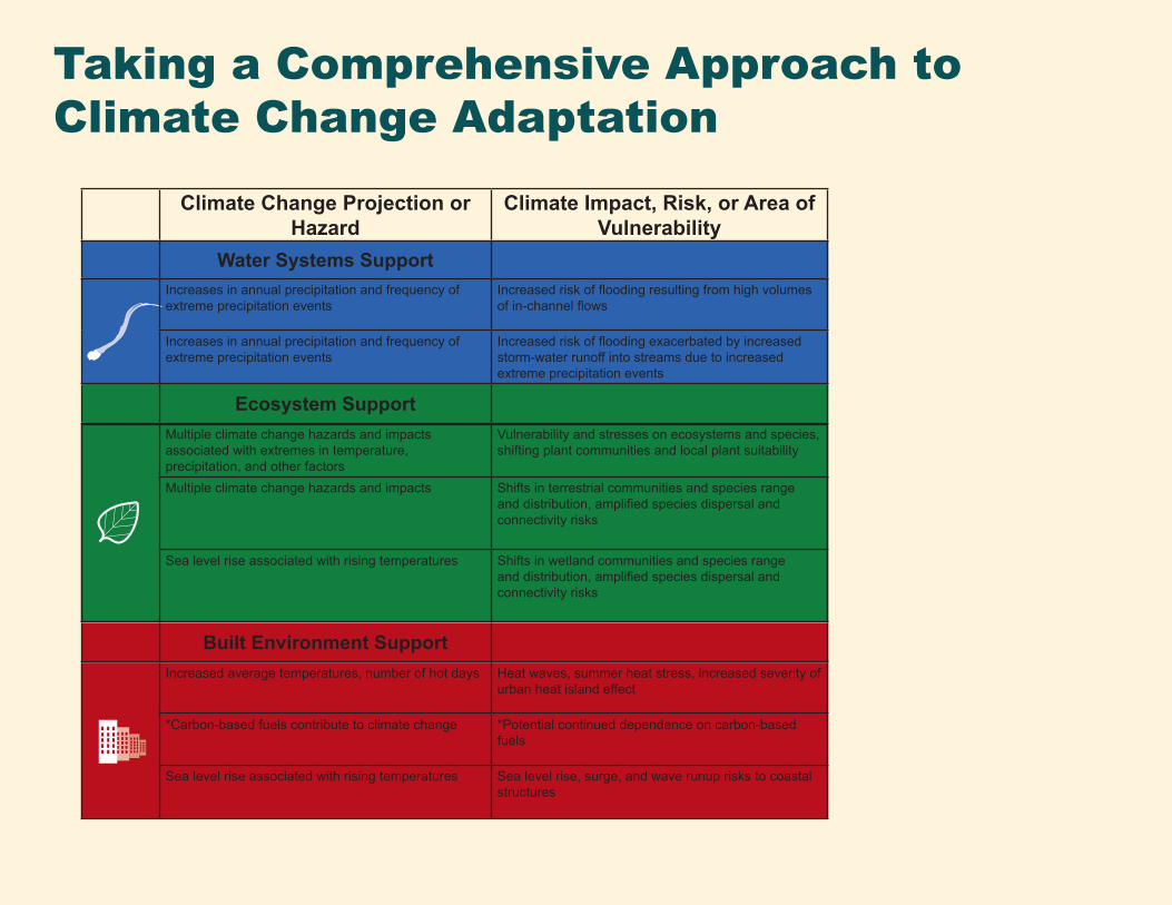
Taking a Comprehensive Approach to Climate Change Adaptation
Climate Change Projection or Hazard
Climate Impact, Risk, or Area of Vulnerability
Water Systems SupportIncreases in annual precipitation and frequency of extreme precipitation events
Increased risk of flooding resulting from high volumes of in-channel flows
Increases in annual precipitation and frequency of extreme precipitation events
Increased risk of flooding exacerbated by increased storm-water runoff into streams due to increased extreme precipitation events
Ecosystem SupportMultiple climate change hazards and impacts associated with extremes in temperature, precipitation, and other factors
Vulnerability and stresses on ecosystems and species, shifting plant communities and local plant suitability
Multiple climate change hazards and impacts Shifts in terrestrial communities and species range and distribution, amplified species dispersal and connectivity risks
Sea level rise associated with rising temperatures Shifts in wetland communities and species range and distribution, amplified species dispersal and connectivity risks
Built Environment SupportIncreased average temperatures, number of hot days Heat waves, summer heat stress, increased severity of
urban heat island effect
*Carbon-based fuels contribute to climate change *Potential continued dependence on carbon-based fuels
Sea level rise associated with rising temperatures Sea level rise, surge, and wave runup risks to coastal structures
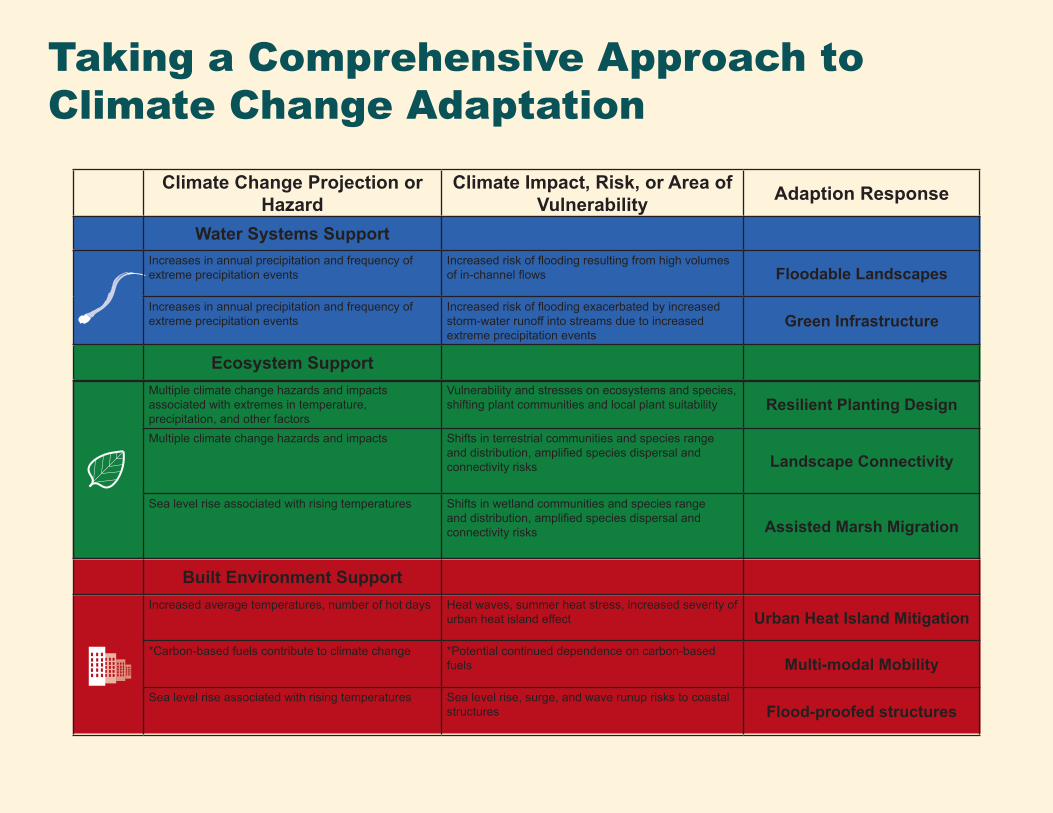
Taking a Comprehensive Approach to Climate Change Adaptation
Climate Change Projection or Hazard
Climate Impact, Risk, or Area of Vulnerability Adaption Response
Water Systems SupportIncreases in annual precipitation and frequency of extreme precipitation events
Increased risk of flooding resulting from high volumes of in-channel flows Floodable Landscapes
Increases in annual precipitation and frequency of extreme precipitation events
Increased risk of flooding exacerbated by increased storm-water runoff into streams due to increased extreme precipitation events
Green Infrastructure
Ecosystem Support Multiple climate change hazards and impacts associated with extremes in temperature, precipitation, and other factors
Vulnerability and stresses on ecosystems and species, shifting plant communities and local plant suitability Resilient Planting Design
Multiple climate change hazards and impacts Shifts in terrestrial communities and species range and distribution, amplified species dispersal and connectivity risks Landscape Connectivity
Sea level rise associated with rising temperatures Shifts in wetland communities and species range and distribution, amplified species dispersal and connectivity risks Assisted Marsh Migration
Built Environment SupportIncreased average temperatures, number of hot days Heat waves, summer heat stress, increased severity of
urban heat island effect Urban Heat Island Mitigation
*Carbon-based fuels contribute to climate change *Potential continued dependence on carbon-based fuels Multi-modal Mobility
Sea level rise associated with rising temperatures Sea level rise, surge, and wave runup risks to coastal structures Flood-proofed structures
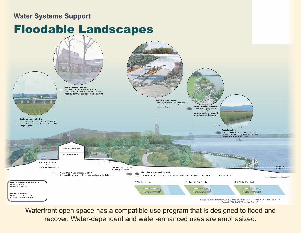
Dunn Farmer’s Market
round farmer’s market to activate the waterfront.
Water Street relocated to back of lot to allow greater park connectivity.
Railway elevated 18 feet
under bridge, and meet the current Ferry Street Bridge at grade.
Public Kayak LaunchCreate a public launch for small craft in slip two, with shoreline stabilized with interplanted riprap. Bioengineered Shoreline
Joint planting RipRap with na-tive wetland plants increases ecological quality without sacri-
Soft ShorelineWhere maintaining the shoreline in place is not necessary for function, riprap can be removed to create a natural wetland shoreline.
Regrade to allow removal of existing retaining wall
High Tide 2080
High Tide 2016
A
A
Floodable Henry Hudson ParkPark maintains current uses in the short-run while new elevated paths will ensure continued access as sea levels rise.
Water Street Commercial DistrictCommercial Development with wide deck overlooking the Hudson.
Ecologically Enhanced ShorelineExisting: 1,444 feet Proposed: 2,733 feet
Commercial SpaceExisting: 325,776 square feet Proposed: 432,194 square feet
Water-Enhanced Commercial:Restaurant
Relocated Power Boat Association
2025 : Current Uses 2050: Intertidal Zone Boardwalk 2080: Wetland Boardwalk
Waterfront open space has a compatible use program that is designed to flood and recover. Water-dependent and water-enhanced uses are emphasized.
Image by Sara Hirsch MLA ‘17, Kyle Sitzman MLA ‘17, and Alice Sturm MLA ‘17 Cornell 2016 LA6020 studio, Cerra.”
Water Systems Support
Floodable Landscapes
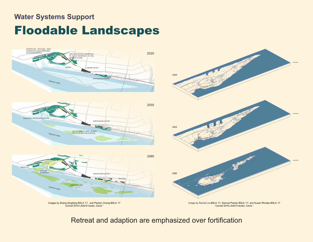
Retreat and adaption are emphasized over fortification
Water Systems Support
Floodable Landscapes2020ABEEL STREET RAISED, UNDERPASSES
TO ALLOW PEDESTRIANS TO PASS, ENTRANCE TO PARK
CONSTRUCTED WETLANDS TREAT STORMWATER RUNOFF FROM ABEEL AND NEIGHBOURHOOD
CARPARK SHIFTED
NATURALIZE SHORELINE
MARINA
RONDOUT CREEK
Images by Zhang QingQing BSLA ‘17, and Pearlyn Chang BSLA ‘17Cornell 2016 LA4010 studio, Cerra.”
HIGH TIDE
2080
HIGH TIDE
2050
HIGH TIDE
2020
Image by Rachel Liu BSLA ‘17, Samuel Packer BSLA ‘17, and Susan Rhodes BSLA ‘17Cornell 2016 LA4010 studio, Cerra.”Image by Sara Hirsch MLA ‘17, Kyle Sitzman MLA ‘17, and Alice Sturm MLA ‘17
Cornell 2016 LA6020 studio, Cerra.”
2050
AMPHITHEATRE & PLAZA
RONDOUT CREEK
FILL TO STABILISE SMALL ISLANDS, CREATE MOUNDS FOR ACCRETION
BOARDWALK, WATERFRONT ACTIVITIES
2080
MARSH WETLAND
AMPHITHEATRE & PLAZA
F&B, RETAIL
WETLAND BOARDWALK
WATER PLAY
RONDOUT CREEK
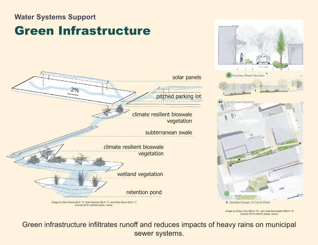
Water Systems Support
Rain Garden Wetland Stormwater System
solar panels
pitched parking lot
climate resilient bioswale vegetation
subterranean swale
climate resilient bioswale vegetation
wetland vegetation
retention pond
2%
B3
B1
B4
Detailed Design of Canal StreetB
1: 200N
Green Infrastructure
Green infrastructure infiltrates runoff and reduces impacts of heavy rains on municipal sewer systems.
Image by Sara Hirsch MLA ‘17, Kyle Sitzman MLA ‘17, and Alice Sturm MLA ‘17 Cornell 2016 LA6020 studio, Cerra.”
Image by Zhijun Guo BSLA ‘16, and Julie Romualdez BSLA ‘16 Cornell 2015 LA4010 studio, Cerra.”
Factory Street SectionA 1: 50
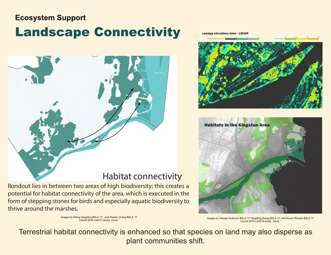
Ecosystem Support
Landscape Connectivity
Terrestrial habitat connectivity is enhanced so that species on land may also disperse as plant communities shift.
Rondout lies in between two areas of high biodiversity; this creates a potential for habitat connectivity of the area, which is executed in the form of stepping stones for birds and especially aquatic biodiversity to thrive around the marshes.
Habitat connectivity
Habitats in the Kingston Area
shrubs and groundcover tree canopy150 5 10 15 20 25 30
canopy elevation data - LIDAR
Images by George Anderson BSLA ‘17 QingQing Zhang BSLA ‘17, and Susan Rhodes BSLA ‘17 Cornell 2016 LA4010 studio, Cerra.”
Images by Zhang QingQing BSLA ‘17, and Pearlyn Chang BSLA ‘17Cornell 2016 LA4010 studio, Cerra.”
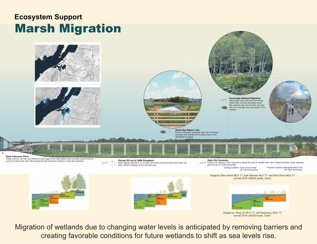
Ecosystem Support-
-
Open Colarusso DriveCreate a formal, two-way road along the south edge of the L&B building which will allow gravel trucks to access the deep-water port without going through downtown Hudson or using the Causeway. Elevate 9G out of 2080 Floodplain
allow wetland migration as the sea-level rises.
Open the CausewayCreate a 40’ opening in the Causeway to double the area of valuable tidal marsh habitat and allow marsh migration;gravel trucks re-routed along L&B.
South Bay Nature TrailBuild an integrated boardwalk loop over the former causeway and elevated 9G providing views of the rehabilitated wetland.
Encourage Wetland MigrationRising water levels will drown the Phrag-mites which currently dominates South Bay; planting wild rice and other rare spe-cies can encourage their colonization of the wetland.
Betula nigraRiver Birch
Orontium aquiaticumGolden Club
Cardamine longiiBittercress
Nuphar advenaSpatterdock
Iris versicolorPeltandra virginicaArrow Arum
Pontederia cordataPickerelweed
Morus rubraRed Mulberry Chionanthus virginicus
Fringetree
Schoenoplectus tabernaemontaniGreat Bullrush
Zizania aquaticaWild Rice
High Tide 2016High Tide 208010% Flood 2080C
Existing Condition: Gravel Access Road No Tidal Connectivity
Proposed Opening: Boardwalk Nature Trail Full Tidal Connectivity
Migration of wetlands due to changing water levels is anticipated by removing barriers and creating favorable conditions for future wetlands to shift as sea levels rise.
Marsh Migration
Image by Sara Hirsch MLA ‘17, Kyle Sitzman MLA ‘17, and Alice Sturm MLA ‘17 Cornell 2016 LA6020 studio, Cerra.”
Images by Ming Chi MLA ‘17, and Xiaoying Li MLA ‘17 Cornell 2016 LA6020 studio, Cerra.”
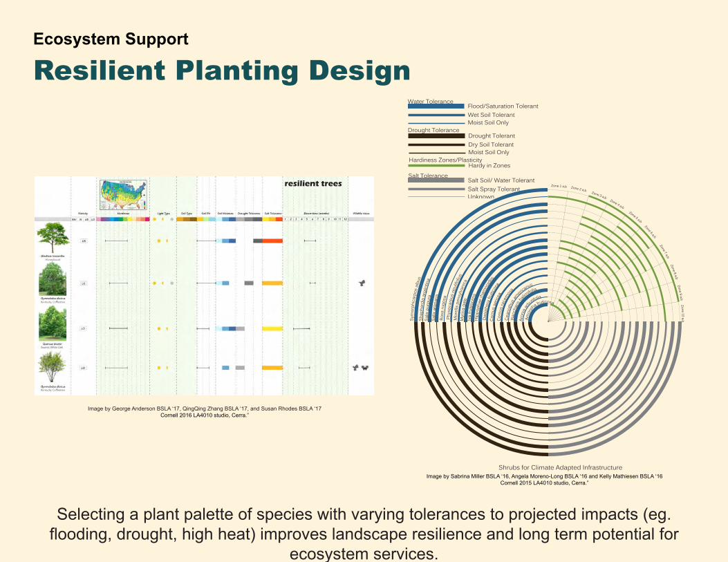
Shrubs for Climate Adapted Infrastructure
Amor
pha fruticosa
Aron
ia ar
butifolia
Bacc
haris
ha
limifolia
Cean
othu
s americ
anus
Cor
nus
race
mos
a
Corn
us s
eric
ea
Das
ipho
ra fr
uitic
osa
Hip
poph
ae rh
amno
ides
Iva
frute
scen
s
Myr
ica
gale
Mor
ella
pen
sylva
nica
Phys
ocar
pus
opul
ifoliu
s
Rosa
rugo
sa
Salix
are
naria
Sym
orph
icar
pos
albu
sSh
ephe
rdia
arg
entin
aSa
lix p
urpu
ra
Zone 1 a,b Zone 2 a,b Zone 3 a,b Zone 4 a,b Zone 5 a,b Zone 6 a,b Zone 7 a,b Zone 8 a,b Zone 9 a,b Zone 10 a,b
Water Tolerance
Wet Soil TolerantMoist Soil Only
Flood/Saturation Tolerant
Dry Soil TolerantMoist Soil Only
Drought TolerantDrought Tolerance
Hardy in ZonesSalt Tolerance
Salt Spray TolerantUnknown
Salt Soil/ Water Tolerant
Hardiness Zones/Plasticity
Ecosystem Support
Selecting a plant palette of species with varying tolerances to projected impacts (eg. flooding, drought, high heat) improves landscape resilience and long term potential for
ecosystem services.
Resilient Planting Design
Image by Sabrina Miller BSLA ‘16, Angela Moreno-Long BSLA ‘16 and Kelly Mathiesen BSLA ‘16Cornell 2015 LA4010 studio, Cerra.”
resilient trees
Image by George Anderson BSLA ‘17, QingQing Zhang BSLA ‘17, and Susan Rhodes BSLA ‘17 Cornell 2016 LA4010 studio, Cerra.”
-
-
Open Colarusso DriveCreate a formal, two-way road along the south edge of the L&B building which will allow gravel trucks to access the deep-water port without going through downtown Hudson or using the Causeway. Elevate 9G out of 2080 Floodplain
allow wetland migration as the sea-level rises.
Open the CausewayCreate a 40’ opening in the Causeway to double the area of valuable tidal marsh habitat and allow marsh migration;gravel trucks re-routed along L&B.
South Bay Nature TrailBuild an integrated boardwalk loop over the former causeway and elevated 9G providing views of the rehabilitated wetland.
Encourage Wetland MigrationRising water levels will drown the Phrag-mites which currently dominates South Bay; planting wild rice and other rare spe-cies can encourage their colonization of the wetland.
Betula nigraRiver Birch
Orontium aquiaticumGolden Club
Cardamine longiiBittercress
Nuphar advenaSpatterdock
Iris versicolorPeltandra virginicaArrow Arum
Pontederia cordataPickerelweed
Morus rubraRed Mulberry Chionanthus virginicus
Fringetree
Schoenoplectus tabernaemontaniGreat Bullrush
Zizania aquaticaWild Rice
High Tide 2016High Tide 208010% Flood 2080C
Existing Condition: Gravel Access Road No Tidal Connectivity
Proposed Opening: Boardwalk Nature Trail Full Tidal Connectivity
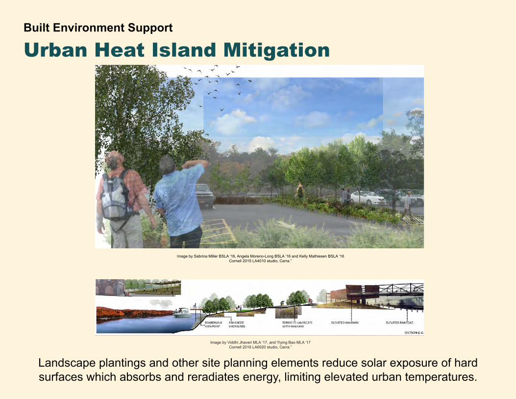
Built Environment Support
Urban Heat Island Mitigation
Landscape plantings and other site planning elements reduce solar exposure of hard surfaces which absorbs and reradiates energy, limiting elevated urban temperatures.
Image by Sabrina Miller BSLA ‘16, Angela Moreno-Long BSLA ‘16 and Kelly Mathiesen BSLA ‘16Cornell 2015 LA4010 studio, Cerra.”
Image by Viddhi Jhaveri MLA ‘17, and Yiying Bao MLA ‘17 Cornell 2016 LA6020 studio, Cerra.”
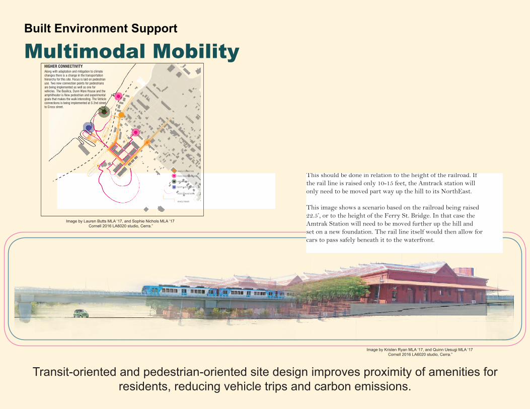
Raising the Amtrak StationThis should be done in relation to the height of the railroad. If the rail line is raised only 10-15 feet, the Amtrack station will only need to be moved part way up the hill to its NorthEast.
This image shows a scenario based on the railroad being raised 22.5’, or to the height of the Ferry St. Bridge. In that case the Amtrak Station will need to be moved further up the hill and set on a new foundation. The rail line itself would then allow for cars to pass safely beneath it to the waterfront.
Built Environment Support
Multimodal Mobility
Transit-oriented and pedestrian-oriented site design improves proximity of amenities for residents, reducing vehicle trips and carbon emissions.
Image by Kristen Ryan MLA ‘17, and Quinn Uesugi MLA ‘17 Cornell 2016 LA6020 studio, Cerra.”
Along with adaptation and mitigation to climate changes there is a change in the transportation hierarchy for this site. Focus is laid on pedestrian use. Two new connection points for pedestrians are being implemented as well as one for vehicles. The Basilica, Dunn Ware House and the amphitheater is New pedestrian and experimental goals that makes the walk interesting. The Vehicle connections is being implemented at S 2nd street to Cross street.
PEDESTRIAN NETWORK
VEHICLE ROADS
HIGHER CONNECTIVITY
SLOOP CLUB PAVILLION
AMPHITHEATRE
PEDESTRIAN CONNECTION
VEHICLE CONNECTION
Image by Lauren Butts MLA ‘17, and Sophie Nichols MLA ‘17 Cornell 2016 LA6020 studio, Cerra.”
20100ft
1ft
2ft
3ft
4ft
5ft
6ft
7ft
8ft
9ft
10ft
11ft
12ft
13ft
14ft
15ft
16ft
2020 2030 2040 2050 2060 2070 2080 2090 2100 2110
Time in Decades
Climax Community
RisingSea Level
SAV Grows
MarshlandGrows
Elev
atio
n ab
ove
Cats
kill
Cree
k at
Mea
n H
igh
Tide
in 2
015
Floodplain Forest Community Elevation Shift
Marshlnad Community Elevation Shift
SAV Community Elevation Shift
A
B
C
A
B
N
0 50 100 200
MAR
KET
AND
WET
LAN
D W
ALK
SUBM
ERG
ED A
QU
ATIC
VEG
ETAT
ION
MAR
SHLA
ND
OLD
MIL
L SC
ULP
TURE
GAR
DEN
ADI P
IER
+ PE
RFO
RMAN
CE
SPAC
E
ELEV
ATED
WET
LAN
D W
ALK
BOAT
LAU
NC
H
FLO
OD
PLAI
N F
ORE
ST
SUBMERGED AQUATIC VEGETATION: provides habitat for spwaning fish. Vegetation consists of herbacious plants that are mostly, if not completely submerged. Species include: Curly Pondweed, Water Celery, Water Chestnut, Clasping Leaf Pondweed.
WETLAND CREATION: ESTABLISHING RIPARIAN ECOSYSTEMS
FLOOD PLAIN FOREST: provides habitat for birds and mammals Vegetation consists of wet tolerant trees, grasses and other small herbacious plants. Species include: Silver Maple, Green Ash, Buttonbush, Bluejoint Grass, Swamp Buttercup.
MARSHLAND: provides habitat for birds and mammals. Vegetation mostly consists of grasses and small herbacious plants. Species include:Cattail, Arrow Arum, Wild Rice, Bulrush, Pickerel Weed.
Silver Maple
Buttonbush
Bluejoint Grass
Swamp Buttercup
Bulrush
Cattail
Wild Rice
Pickerel Weed
Arrow Arum
Water Chestnut
Water Celery
Curly Pondweed
Clasped Pondweed
HP
HP
HP
HP
LP
HP
HP
HPS
C
C
C’
C’
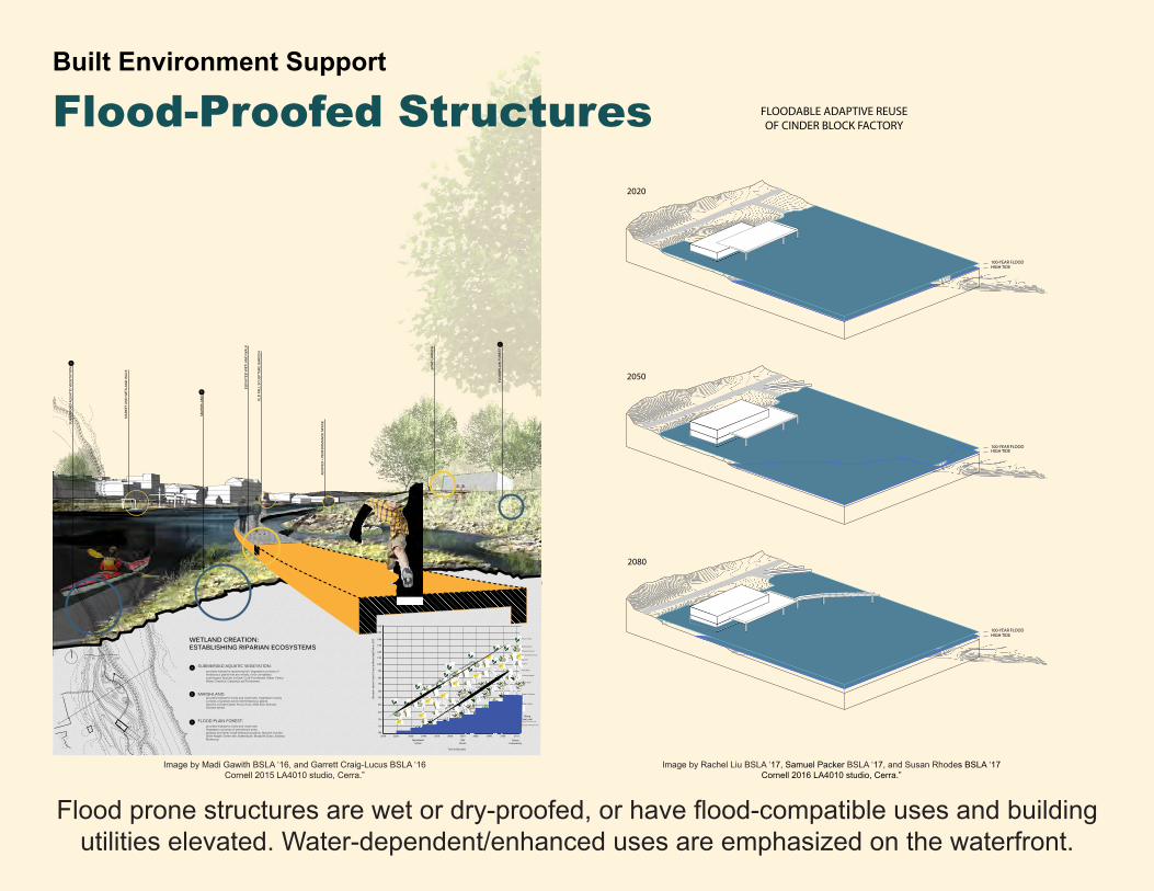
Built Environment Support
Flood-Proofed Structures
Flood prone structures are wet or dry-proofed, or have flood-compatible uses and building utilities elevated. Water-dependent/enhanced uses are emphasized on the waterfront.
Image by Madi Gawith BSLA ‘16, and Garrett Craig-Lucus BSLA ‘16Cornell 2015 LA4010 studio, Cerra.”
2080
2050
100-YEAR FLOODHIGH TIDE
100-YEAR FLOODHIGH TIDE
2020
100-YEAR FLOODHIGH TIDE
FLOODABLE ADAPTIVE REUSEOF CINDER BLOCK FACTORY
Image by Rachel Liu BSLA ‘17, Samuel Packer BSLA ‘17, and Susan Rhodes BSLA ‘17Cornell 2016 LA4010 studio, Cerra.”
Key Moves
•Shore Line SofteningBeginning rennovations on the waterfront, softening the shoreline and preparing it for innundation
•Bioretention ParksPreparing the Bioretention Parks for Storm water runnoff, connecting overflow pipes, preparing the grade.
•2nd Street OpeningReopening 2nd Street as a oneway road.
•Dear Valley Road OpeningConnecting to 2nd Street.
•Trolley Line OpeningBuy a trolley and establish route.
•Front Street RennovationRegrade Front street to drain appropriately and add sidewalks
•Flood ProofingWet flood proofing for the Train Station, Dunn Building. Basilica and New Develop-ment
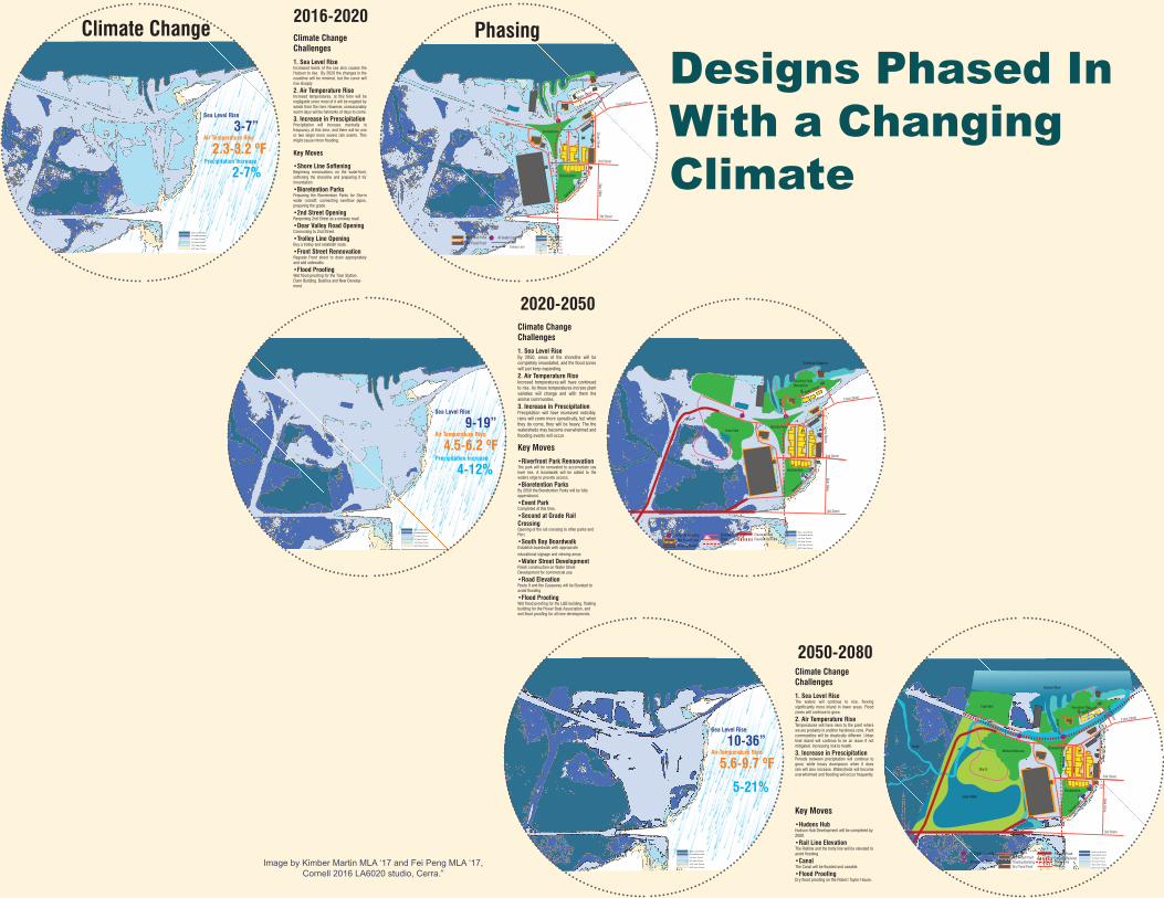
Climate Change Challenges1. Sea Level RiseIncreased levels of the sea also causes the Hudson to rise. By 2020 the changes in the coastline will be minimal, but the curve will rise sharply
2. Air Temperature RiseIncresed temperatures, at this time will be negligable since most of it will be negated by winds from the river. However, unseasonably warm days will be halmarks of days to come.
3. Increase in Prescipitation Precipitation will increase marinally in frequancy at this time, and there will be one or two larger more severe rain events. This might cause minor flooding.
Inundated Area
10 Year Flood
50 Year Flood
100 Year Flood
500 Year Flood
Sea Level Rise
NORTHSCALE IN FEETSCALE: 1"=40'
0 40' 80'20'
SCALE IN FEETSCALE: 1"=40'
0 40' 80'Inundated Area
10 Year Flood
50 Year Flood
100 Year Flood
500 Year Flood
Sea Level Rise
Bioretention
Bioretention
Creek
RoadTrolley Line
2nd Street
3rd Street
Front StreetWater Street
Broad Street
Dear AlleyCross Street
Tanne
rs Lan
e
At Grade CrossingWet Flood Proof
Dry Flood Proof
Shoreline Adaption
°F
Climate Change2016-2020
Phasing
Sea Level Rise
3-7”Air Temperature Rise
2.3-3.2 ºF Precipitation Increase
2-7%
Climate Change Challenges1. Sea Level RiseBy 2050, areas of the shoreline will be completely innundated, and the flood zones will just keep expanding.
2. Air Temperature RiseIncresed temperatures,will have continued to rise. As these temperatures incrase plant varieties will change and with them the animal communites.
3. Increase in Prescipitation Precipitation will have increased noticibly. rains will come more sporatically, but when they do come, they will be heavy. The the watersheds may become overwhelmed and flooding events will occur.
Key Moves•Riverfront Park RennovationThe park will be ronovated to accomodate sea level rise. A boardwalk will be added to the waters edge to provide access.
•Bioretention ParksBy 2050 the Bioretention Parks will be fully opperational.
•Event ParkCompleted at this time.
•Second at Grade Rail CrossingOpening of the rail crossing to other parks and Port.
•South Bay BoardwalkEstablish boardwalk with appropriate
educational signage and viewing areas.
•Water Street DevelopmentFinish construction on Water Street Development for commercial use.
•Road ElevationRoute 9 and the Causeway will be Elevated to avoid flooding
•Flood ProofingWet flood proofing for the L&B building, floating building for the Power Boat Association, and wet flood proofing for all new developments.
2020-2050
Inundated Area
10 Year Flood
50 Year Flood
100 Year Flood
500 Year Flood
Sea Level Rise
Wet Flood Proof
Floating Building
Event ParkBioretention
Bioretention
Gree
n Ro
of
Elevated RoadRoad Elevated RailroadBoardwalk
Trolley Line
At Grade Crossing
2nd Street
3rd Street
Front StreetWater Street
Broad Street
Dear AlleyCross Street
Tanne
rs Lan
e
20'
SCALE IN FEETSCALE: 1"=40'
0 40' 80'
Shoreline Adaption
Riverfront Park Renovation
Inundated Area
10 Year Flood
50 Year Flood
100 Year Flood
500 Year Flood
Sea Level Rise
NORTHSCALE IN FEETSCALE: 1"=40'
0 40' 80'
Sea Level Rise
9-19”Air Temperature Rise
4.5-6.2 ºF Precipitation Increase
4-12%
Key Moves
•Hudons HubHudson Hub Development will be completed by 2080.
•Rail Line ElevationThe Railline and the trolly line will be elevated to avoid flooding
•CanalThe Canal will be flooded and useable.
•Flood ProofingDry flood proofing on the Robert Taylor House.
Inundated Area
10 Year Flood
50 Year Flood
100 Year Flood
500 Year Flood
Sea Level Rise
3rd St
L&B
Basilica
DunnWarehouse
RobertTaylorHouse
Hotel
Amtrak
Station
Relish
HudsonPower BoatAssociation
Ferry St
Water St
Front St
Broad St
20'
SCALE IN FEETSCALE: 1"=40'
0 40' 80'
Canal
Open Water
Tidal Wetland
Tidal Pool
Hudson River
Creek
Marsh
Riverfront ParkTidal Park
Wetland ReserveBioretention
Bioretention
Gree
n Ro
of
Elevated Road
Road
Elevated Railroad
Boardwalk
Trolley Line
At Grade Crossing
Bridge Crossing
2nd Street
3rd Street
Front StreetWater Street
Broad Street
Dear AlleyCross Street
Tanne
rs Lan
e
Ferry Street
Wet Flood ProofFloating BuildingDry Flood Proof
2050-2080Climate Change Challenges
1. Sea Level RiseThe waters will continue to rise, flowing significantly more inland in lower areas. Flood zones will continue to grow.
2. Air Temperature RiseTemperatures will have risen to the point where we are probably in another hardiness zone. Plant communities will be drastically different. Urban heat island will continue to be an issue if not mitigated. Increasing risk to health.
3. Increase in Prescipitation Periods between precipitation will continue to grow, while heavy downpours when it does rain will also increase. Watersheds will become overwhelmed and flooding will occur frequently.
Inundated Area
10 Year Flood
50 Year Flood
100 Year Flood
500 Year Flood
Sea Level Rise
NORTHSCALE IN FEETSCALE: 1"=40'
0 40' 80'
Sea Level Rise
10-36”Air Temperature Rise
5.6-9.7 ºF
5-21%
Designs Phased In With a Changing Climate
Image by Kimber Martin MLA ‘17 and Fei Peng MLA ‘17, Cornell 2016 LA6020 studio, Cerra.”
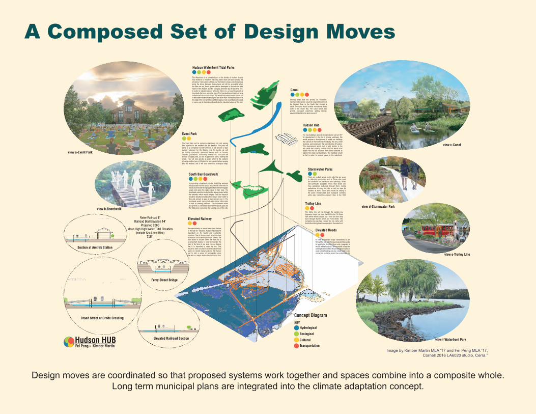
Hudson Waterfront Tidal Parks
Event Park
South Bay Boardwalk
Elevated Roads
Trolley Line
Elevated Railway
Stormwater Parks
Hudson Hub
Canal
The Waterfront is an important part of the identity of Hudson despite how limited it is. However, the rising water levels will soon change the shoreline. Tidal waters will flow over the historic sloops and other places along the shore. Because these places will still be accessible when the tides are out, these spaces can be developed to illustrate the tidal nature of the hudson and the changing shoreline due to sea level rise. In order to maintain access when the tide is in, we want to provide a boardwalk that runs along the shore The boardwalk would also act as a embarkment area for tour boats. This would help to keep people connected to the waterfront and potentially the rest of the river.The industrial nature of the edge of the river and the neighboring gravel site would be incorporated in some way to illustrate and celebrate the industrial values of the river.
Utilizing areas that will already be inundated, minimum intervention would be required to connect the Hudson River to the South Bay through a canal. The canal would provide recreational water route to the South Bay. The canal would also provide increased waterfront, adding interest, value and habitat to the land around it.
The Caz building is soon to be demolished and an RFP for development in the site is already underway. We would propose a development of mixed use buildings that carried on the traditions of industry, the arts, small business, and community that are indicative of hudson. This development would help to add density to the site, while also creating a center that that would draw people into the site and then from there outwards to explore the areas surrounding it. The buildings would be tall in order to provide views to the waterfront.
There are multiple areas on the site that are prone to collecting storm water as it is. These sites could be formalized and developed with plantings, drains and permeable subgrade. These sites would also have pedestrian walkways through them, inviting pedestrians to cross the site as well as view the systems at work. These sites would be adding to the green infrastructure and ecological corridors, while also connecting adjacent sites to the HUB.
Because industry as moved away from Hudson in the last few decades, Hudson has become dependant on it’s tourist and weekender economy. One of the reasons it is such a draw is because it is located right on the railway. The train station is located within the HUB and is an important feature. In order to maintain the train in the face of sea level rise we believe that it is important to raise the line. This would be done on piles in order to allow flood waters to recede easily back into the Hudson and to add a sense of permeability since the rail is a major obstruction to the rail line.
The trolley line will run through the existing low frequency freight line from the HUB to the 7th Street Park where events usually start from and then loop back through Warren Street and Front Street. This complete loop can help connect the city center with the HUB and bring down more people to the waterfront.
In order to maintain major connections to and through the site, both the causeway and 9G is going to have to be elevated. Since only a segment of the 9G will be flooded, it is reasonable to keep the existing footprint of the 9G and elevated on piles to avoid future flooding and also create better water connection by letting water flow underneath 9G.
Incorporating a boardwalk into the South Bay wetlands brings people into the space, which would otherwise be mostly inaccessible. Bringing people into the site engages people and gives the space value in their eyes. The Boardwalk would be located on the higher ground within the wetlands which would mitigate cost and impact.It would be situated on piles which would allow water to flow and animals to pass or even shelter uner it. The boardwalk would also include educational information as well as viewing platforms. This Boardwalk would also provide a connection between the Event park and the Tidal park, increasing the walking area of the site.
The Event Park will be replacing abandoned lots and parking lots adjacent to the wetland and the Basilica. The park will serve as a companion to both of these. It will provide a large outdoor extension for the Basilica and it’s events, as well as hosting community sponsored events such as farmers markets, graduations, community theaters etc. The park will include a staging area, as well as peripheral paths, seating and shade. This will also provide a green buffer to the wetland, allowing another layer of filtration for stormwater before seeping into the wetland, and it will also extend its ecological edge.
Concept DiagramKEY
Hydrological
Ecological
Cultural
Transportation
view a-Event Park
view b-Boardwalk
Section at Amtrak Station
Broad Street at Grade Crossing
Ferry Street Bridge
Elevated Railroad Section
view c-Canal
view d-Stormwater Park
view e-Trolley Line
view f-Waterfront Park
Fei Peng+ Kimber MartinHudson HUB
Raise Railroad 6’Railroad Bed Elevation 14’
Projected 2080Mean High High Water Tidal Elevation
(include Sea Level Rise)7.21’
Design moves are coordinated so that proposed systems work together and spaces combine into a composite whole. Long term municipal plans are integrated into the climate adaptation concept.
A Composed Set of Design Moves
Image by Kimber Martin MLA ‘17 and Fei Peng MLA ‘17, Cornell 2016 LA6020 studio, Cerra.”
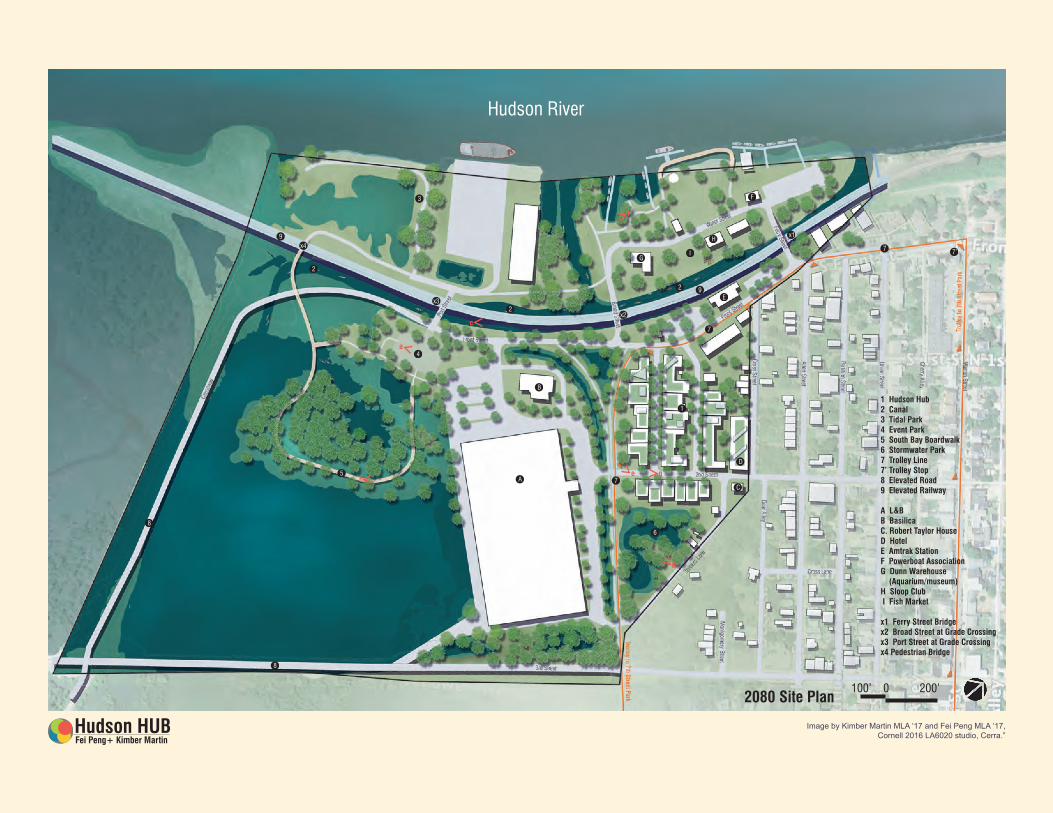
0 200’100’
1
A 7
6
4
5
x4
x3
x2
92
2
2
x1
B
8
8
C
D
E
G
F
9
1 Hudson Hub2 Canal3 Tidal Park4 Event Park5 South Bay Boardwalk6 Stormwater Park7 Trolley Line7’ Trolley Stop8 Elevated Road9 Elevated Railway
A L&BB BasilicaC. Robert Taylor HouseD HotelE Amtrak StationF Powerboat AssociationG Dunn Warehouse (Aquarium/museum)H Sloop Club I Fish Market
x1 Ferry Street Bridgex2 Broad Street at Grade Crossingx3 Port Street at Grade Crossingx4 Pedestrian Bridge
Hudson River
3
7
7 7’I
H
2080 Site Plan
Fei Peng+ Kimber MartinHudson HUB
f
a
c
b
d
e g
Image by Kimber Martin MLA ‘17 and Fei Peng MLA ‘17, Cornell 2016 LA6020 studio, Cerra.”