Embed Size (px)
Citation preview

Part two - nomenclature illustrations
CORINE land cover 95
Part Two
Nomenclature:illustrations

Part two - nomenclature illustrations
CORINE land cover 96
Part I of this guide should be consulted in order to understand the logic behind the CORINE land cover nomenclature, and theprocedures for locating, delineating and identifying land cover units during the satellite image interpretation phase.
Part 2 reflects the structure of the CORINE land cover nomenclature, which provides a conceptual framework for understanding thedifferent types of land cover. For each item of the nomenclature the guide includes a satellite image, delineation of a unit on theimage, an example of a document (ancillary or additional documentation) which will help delineate and identify the unit, and a shortcommentary on the three illustrations. The illustrations used here have been provided by the various national teams taking part inthe project. The CORINE land cover central team would like all the teams to send it further examples of land cover in the formatused here.

Part two - nomenclature illustrations
CORINE land cover 97
Photointerpretation keys
Photointerpretation keys are a tool with which to describe the appearance of the various categories of land cover on satelliteimages. These variables enable the photointerpreter to make comparable descriptions of units from the 44 items of thenomenclature and thus facilitate the interpretation work. Each unit appearing on a satellite image can be described using thefolowing variables.
Variables
Variables Options
Precision of contours: nature of the boundary between two units SharpBlurredAngularRegular
Colour/hue: depending on vegetation density, slope, orientation All coloursVariations:- Light- Dark- Pale- Variable
Size: indication of the most frequent surface area of units in the category Small: less than 1 km2Medium: between 1 and5 km2Large: more than 5 km2
Texture: arrangement of different tones on the image. Texture is defined by the Fine: < 50 mconfiguration of the which are too small to be seen individually. Texture must Medium: 50 to 250 mnot be confused with detail. Texture expresses the average size of the Coarse: > 250 m constituent elements of the image. Smooth
Visible texture
Structure: spatial organization of the constituent element of the image, Homogeneousdescribed solely in terms of their spatial properties. Linear Structure expresses 'breaks' in average pixel values. Cellular
IrregularSpeckledSpaghetti
Spatial distribution: indication of the geographical distribution of Longitudinalunits in the satellite image as a whole Dispersed
RegularIrregularSporadicErraticConcentratedGroupedVariable
Location: description of the normal physiographic positions of Example: port area nearthe category within an overall landscape. an urban area

Part two - nomenclature illustrations
CORINE land cover 98
1. Artificiel surfaces
2. Agricultural areas
3. Forests and semi-natural areas
4. Wetlands
5. Water bodies
Part two - nomenclature illustrations
CORINE land cover 99
1. Artificiel surfaces
1.1. Urban fabric
1.2. Industrial, commercial and transport units
1.3. Mine, dump and construction sites
1.4. Artificial non-agricultural vegetaded areas

Part two - nomenclature illustrations
CORINE land cover 100
1.1. Urban fabric
1.1.1. Continuous urban fabric
1.1.2. Discontinuous urban fabric
Part two - nomenclature illustrations
CORINE land cover 101
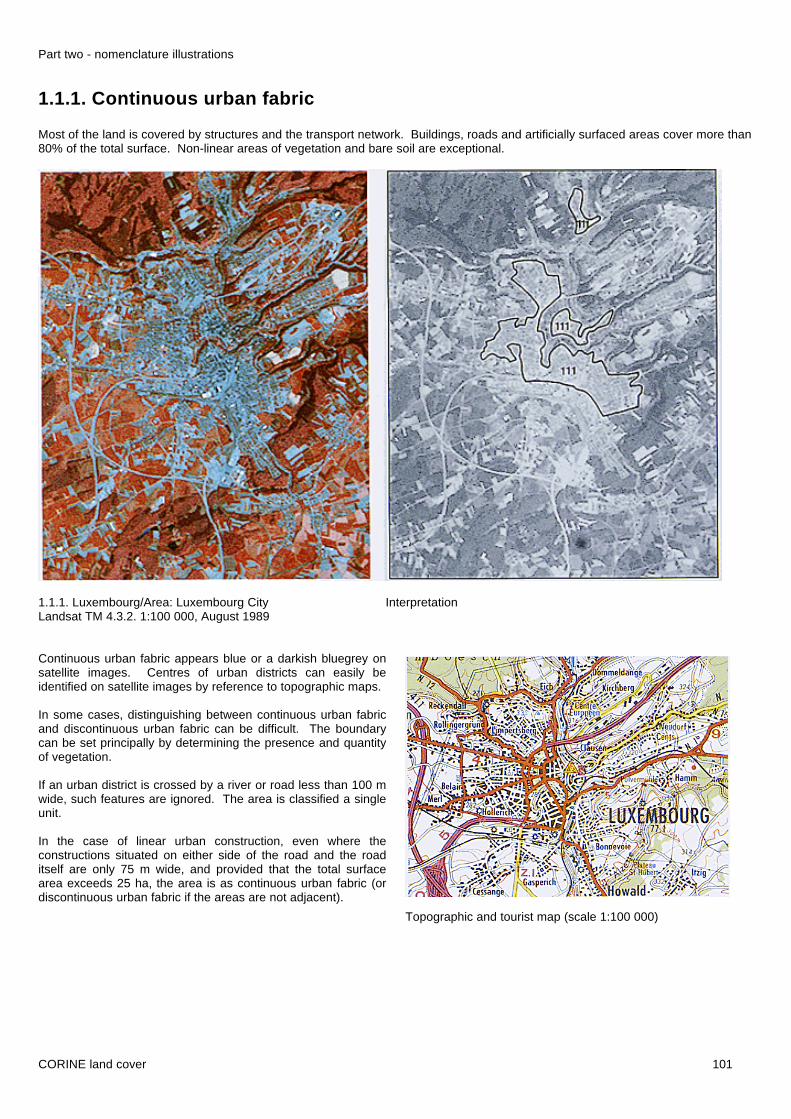
1.1.1. Continuous urban fabric
Most of the land is covered by structures and the transport network. Buildings, roads and artificially surfaced areas cover more than80% of the total surface. Non-linear areas of vegetation and bare soil are exceptional.
1.1.1. Luxembourg/Area: Luxembourg City InterpretationLandsat TM 4.3.2. 1:100 000, August 1989
Continuous urban fabric appears blue or a darkish bluegrey onsatellite images. Centres of urban districts can easily beidentified on satellite images by reference to topographic maps.
In some cases, distinguishing between continuous urban fabricand discontinuous urban fabric can be difficult. The boundarycan be set principally by determining the presence and quantityof vegetation.
If an urban district is crossed by a river or road less than 100 mwide, such features are ignored. The area is classified a singleunit.
In the case of linear urban construction, even where theconstructions situated on either side of the road and the roaditself are only 75 m wide, and provided that the total surfacearea exceeds 25 ha, the area is as continuous urban fabric (ordiscontinuous urban fabric if the areas are not adjacent).
Topographic and tourist map (scale 1:100 000)

Part two - nomenclature illustrations
CORINE land cover 102
1.1.2. Discontinuous urban fabric
Most of the land is covered by structures. Buildings, roads and artificially surfaced areas are associated with vegetated areas andbare soil, which occupy discontinuous but significant surfaces.
Belgium/Area: Brasschaat InterpretationLandsat TM 4.5.3 1:100 000, May 1989
Discontinuous urban fabric comprises residential areas aroundthe edge of urban district centres, and certain urban districts inrural areas.
These units consist of blocks of flats, individual houses,gardens, streets and parks, each of these elements having asurface area of less than 25 ha.
This type of land cover can be distinguished from continuousurban fabric by the presence of non-impermeabilized surfaces:gardens, parks, planted areas and non-surfaced public areas.
Buildings, roads and artificially surfaced areas cover between50 and 80% of the total surface area of the unit.
The illustration shows the complex delineation of residentialareas under tree cover.
This item of the nomenclature does not include scatteredagricultural habitation (comprising agricultural building orshelters) or scattered main and secondary residences in naturalor agricultural areas.
Aerial photograph, natural colors

Part two - nomenclature illustrations
CORINE land cover 103
1.2. Industrial, commercial and transport units
1.2.1. Industrial or commercial units
1.2.2. Road and rail networks and associated land
1.2.3. Port areas
1.2.4. Airports

Part two - nomenclature illustrations
CORINE land cover 104
1.2.1. Industrial or commercial units
Artificially surfaced areas (cement, asphalt, tarmacadam, or stabilised, e.g. beaten earth) without vegetation occupymost of the area, which also contains buildings and/or vegetation,
Portugal/Area: Sines InterpretationLandsat MSS 7.5.4 1:100 000, August 1985
This category of land cover is identified mainly with the aid oftopographic maps or aerial photographs. lt is possible to detectand delineate new industrial sites not yet included ontopographic maps by comparing their texture and structure withareas of this type which already appear on the maps. Typically,the texture will be heterogeneous (mixture of large buildings, carparks, sheds, etc.). Areas under 1.2.1. represent entireindustrial or commercial complexes, including access roads,landscaped areas, car parks, etc. Very large dump sites (> 25ha) are not included in this category.
Industrial or commercial units located in continuous ordiscontinuous urban fabric are taken into account only if theyare clearly distinguishable from residential areas (industrialcomplex with a surface area greather than 25 ha withassociated spaces: car parks, storage areas, etc.).
Sanatoriums, spa facilities, hospitals, rest homes, militarybases, educational establishments, university sites, commercialcentres bordering on or outside urban districts are associatedwith this category, as are associated surfaces such as carparks, sports grounds, wasteland, etc., with a surface area ofless than 25 ha. The category also includes major industriallivestock rearing facilities, waste water treatment plants, cementfish farming ponds. Large greenhouse surfaces are notincluded under this heading.
Panchromatic aerial photograph

Part two - nomenclature illustrations
CORINE land cover 105
1.2.2. Road and rail networks and associated landMotorways and railways, including associated installations (stations, platforms, embankments). Minimum width for inclusion: 100m.
1.2.2. France/Area: Arcachon InterpretationSPOT 3.2.1 1:100 000, March 1989
The mapped surface must measure at least 25 ha and have awidth of at least 100 m. Most transport infrastructure in Europeis less than 100 m wide.
Category 1.2.2 is composed mainly of large road intersectionswith associated infrastructure and planted areas, and largemarshalling yards.
Aerial photographs provide particularly useful ancillary datahere. Networks less than 100 m wide in industrial complexesand urban areas will be classified as 'industrial unit' or 'urbanfabric', accordingly.
The aim should always be to trace a continuous line, ignoringbreaks caused by the regeneration of vegetation. Accountshould be taken of any fire breaks along railway tracks.
Very high tension electric lines over low vegetation are not to betaken into account
Topographic (scale 1:50 000)

Part two - nomenclature illustrations
CORINE land cover 106
1.2.3. Port areas
Infrastructure of port areas, including quays, dockyards and marinas.
1.2.3. Portugal/Area: Porto InterpretationLandsat TM 4.5.3. 1:100 000, July 1987
In delineating heading 1.2.3 account must be taken of thegeographical location (proximity of the sea or a waterway). Useof topographic maps and arial photographs is highlyrecommended. Port area include port infrastructure in the strictsense (quays, sheds, warehouses). Industrial and commercialunits located in immediate proximity should be singled out onlyif they cover more than 25 ha and are clearly identifiable on thedocuments used in the project: satellite images, topographicmaps, aerial photographs.
Dykes and associated spaces are to be considered only if theymeasure 100 m or more across. Inland and marine basins arenot normally included in the surface area of built-up port areas,though where dykes and built-up port installations (maritimeterminal, warehouse quays) are less than 100 m wide and/oroccupy less than 25 ha, the surface area of the basins (fresh orsalt water) delineated by the dykes is to be included in thecalculation of the 25 ha.
Marinas should not be classified under 1.4.2. Panchromatic aerial photograph

Part two - nomenclature illustrations
CORINE land cover 107
1.2.4. Airports
Airport installations: runways, buildings and associated land.
1.2.4. Great Britain/Area: Bedford InterpretationLandsat TM 4.5.3.. 1:100 000
Artificial runways surrounded by grassed areas are easilydistinguishable on the satellite image.
Buildings (offices, terminal buildings, hangars, workshops,warehouses, storage tanks, car parks), grassed areas andassociated spaces are included in the airport surface area.Heliports are also included in this category if they cover at least25 ha.
Wooded and agricultural areas close to airport infrastructurewith a surface area greater than 25 ha should be identified,except for a 100 m strip around the visible infrastructure.
In very many cases, airport territory indicated on the ground bya fence or a path will appear on large-scale topographic maps(1:25000 and 1:50000).
Automatic classification

Part two - nomenclature illustrations
CORINE land cover 108
1.3. Mine, dump and constrution sites
1.3.1 Mineral extraction sites
1.3.2. Dump sites
1.3.3. Construction sites
Part two - nomenclature illustrations
CORINE land cover 109
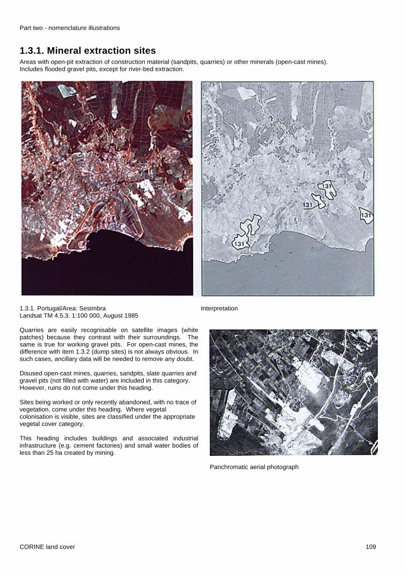
1.3.1. Mineral extraction sitesAreas with open-pit extraction of construction material (sandpits, quarries) or other minerals (open-cast mines).Includes flooded gravel pits, except for river-bed extraction.
1.3.1. Portugal/Area: Sesimbra InterpretationLandsat TM 4.5.3. 1:100 000, August 1985
Quarries are easily recognisable on satellite images (whitepatches) because they contrast with their surroundings. Thesame is true for working gravel pits. For open-cast mines, thedifference with item 1.3.2 (dump sites) is not always obvious. Insuch cases, ancillary data will be needed to remove any doubt.
Disused open-cast mines, quarries, sandpits, slate quarries andgravel pits (not filled with water) are included in this category.However, ruins do not come under this heading.
Sites being worked or only recently abandoned, with no trace ofvegetation, come under this heading. Where vegetalcolonisation is visible, sites are classified under the appropriatevegetal cover category.
This heading includes buildings and associated industrialinfrastructure (e.g. cement factories) and small water bodies ofless than 25 ha created by mining.
Panchromatic aerial photograph

Part two - nomenclature illustrations
CORINE land cover 110
1.3.2. Dump sites
Public, industrial or mine dump sites.
1.3.2. Luxembourg/Area: Differdange InterpretationLandsat TM 4.3.2. 1:100 000, August 1989
Dump sites are very difficult to recognise on satellite images astheir spectral signature varies. Only by their structure and theirtypical round shape can the photointerpreter locate dump sitesnear large towns and major industrial areas. Colonisation bydifferent types of vegetation can make interpretation even morecomplex. Examination of aerial photographs and/or a visit tothe site will often be necessary.
Dump sites of less than 25 ha located next to manufacturingindustries (e.g. sawmills) should be classified under1.2.1 (industrial and commercial units).
Topographic map (scale 1:20 000)
Part two - nomenclature illustrations
CORINE land cover 111
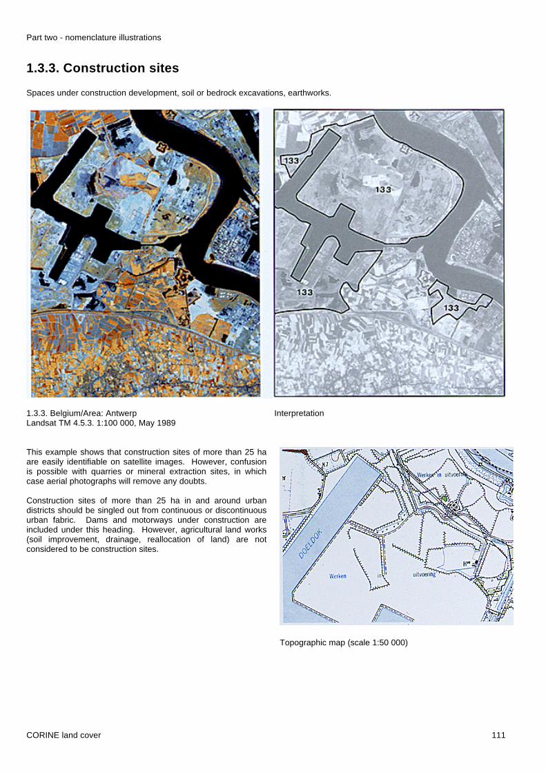
1.3.3. Construction sites
Spaces under construction development, soil or bedrock excavations, earthworks.
1.3.3. Belgium/Area: Antwerp InterpretationLandsat TM 4.5.3. 1:100 000, May 1989
This example shows that construction sites of more than 25 haare easily identifiable on satellite images. However, confusionis possible with quarries or mineral extraction sites, in whichcase aerial photographs will remove any doubts.
Construction sites of more than 25 ha in and around urbandistricts should be singled out from continuous or discontinuousurban fabric. Dams and motorways under construction areincluded under this heading. However, agricultural land works(soil improvement, drainage, reallocation of land) are notconsidered to be construction sites.
Topographic map (scale 1:50 000)

Part two - nomenclature illustrations
CORINE land cover 112
1.4. Artificial non-agricultural vegetated areas
1.4.1. Green urban areas
1.4.2. Sport and leisure facilities

Part two - nomenclature illustrations
CORINE land cover 113
1.4.1. Green urban areas
Areas with vegetation within the urban fabric, including parks, cemeteries with vegetation, and mansions and their ground.
1.4.1. France/Area: Bordeaux InterpretationSPOT XS 3.2.1., July 1987
This category cobers a wide variety of surfaces : public parks,private green areas, cemeteries with vegetation, covering anarea of more than 25 ha. Topographic maps and aerialphotographs may be consulted to identify and delineate thesesurfaces.
Cemeteries with al little or no vegetation should not bedistinguished from headings 1.1.1 and 1.1.2
Topographic map (scale 1:25 000)

Part two - nomenclature illustrations
CORINE land cover 114
1.4.2. Sport and leisure facilities
Camping grounds, sports grounds, leisure parks, golf courses, racecourses, etc. Includes formal parks not surrounded by urbanareas.
1.4.2. Portugal/Area: Faro InterpretationLandsat TM 4.5.3. 1:100 000, August 1985
The example of a golf course in Portugal shows the typicalspaghetti' appearance of such areas. The entire surface,including buildings and associated infrastructure, must beincluded under this item of the nomenclature.
Other features, such as sporting or leisure facilities, are betteridentified on aerial photographs or by visiting the area. Thedistinction between this heading and the 'green urban areas'category is not always obvious, so ancillary data must be used.
Holiday villages and buildings in ski resorts should be classedas urban surfaces, though camp-site infrastructures come under1.4.2. Beaches, ski slopes, school and military sports facilities,hospital grounds (psychiatric and other) and spa facilities do notcome under this heading. On the other hand, sports centres,go-kart and motocross terrains, horse-riding centres and formalparks (mansion grounds) not surrounded by urban fabric docome under this heading.
Panchromatic aerial photograph