Embed Size (px)
Citation preview
Corangamite Waterway Strategy Community Consultation Draft
2 July 2014
1. Regional Overview
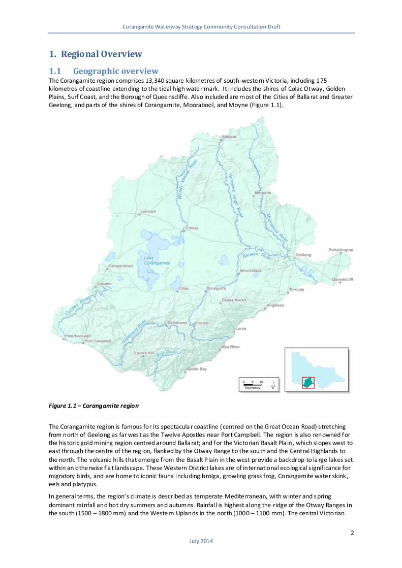
1.1 Geographic overview The Corangamite region comprises 13,340 square kilometres of south-western Victoria, including 175 kilometres of coastline extending to the tidal high water mark. It includes the shires of Colac Otway, Golden Plains, Surf Coast, and the Borough of Queenscliffe. Also included are most of the Cities of Balla rat and Grea ter Geelong, and pa rts of the shires of Corangamite, Moorabool, and Moyne (Figure 1.1).
Figure 1.1 – Corangamite region
The Corangamite region is famous for its spectacula r coastline (centred on the Great Ocean Road) s tretching from north of Geelong as far west as the Twelve Apostles near Port Campbell. The region is also renowned for the his toric gold mining region centred around Balla rat; and for the Victorian Basalt Pla in, which slopes west to east through the centre of the region, flanked by the Otway Range to the south and the Central Highlands to
the north. The volcanic hills that emerge from the Basalt Plain in the west provide a backdrop to la rge lakes set within an otherwise fla t landscape. These Western District lakes are of international ecological s ignificance for migratory birds, and are home to iconic fauna including brolga, growling grass frog, Corangamite water skink, eels and platypus.
In general terms, the region’s climate is described as temperate Mediterranean, with winter and spring
dominant rainfall and hot dry summers and autumns. Rainfall is highest along the ridge of the Otway Ranges in the south (1500 – 1800 mm) and the Western Uplands in the north (1000 – 1100 mm). The central Victorian
Corangamite Waterway Strategy Community Consultation Draft
3 July 2014
Volcanic Plain experiences much lower rainfall (500 – 600 mm), with the lowest rainfa ll recorded east of the Brisbane Ranges (400 – 500 mm). The future climate of the region is expected to be hotter and drier than today, with a higher frequency of extreme weather events, including an increased number of hot days, a
reduced number of frosts. The greatest rainfall reductions are expected to occur in the spring.
78 % of the 1.3 million ha of land in the region is in private ownership, of which land use is varied and generally tied to land systems and climate. Primary production is important in the region and major industries include grazing, cropping, dairy, plantation forestry and horticulture.
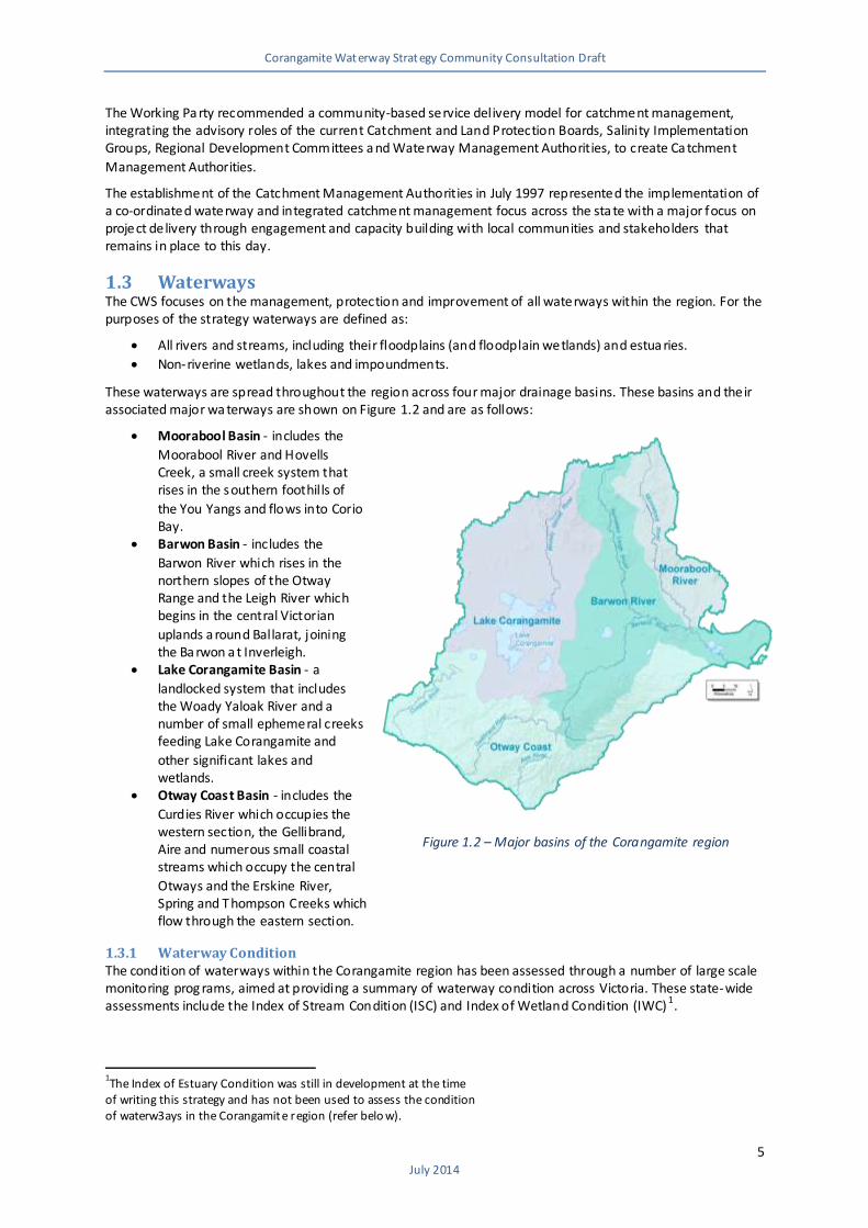
The Corangamite region consists of four drainage basins that ref lect the geology and landscape evolution of
the region. These basins are the Ba rwon River, Lake Corangamite, Moorabool River a nd Otway Coast (refer to Figure 1.2 below). The major population centres of Ballara t and Geelong are bec oming increasingly urbanised, encroaching on surrounding agricultural areas. The spatial distribution of the population is cha nging, with significant expans ion in the coasta l areas including Armstrong Creek, Torquay and the Bellarine Peninsula, as well as the Ballarat to Greater Geelong corridor centred on Bannockburn.
1.2 History
1.2.1 Pre-European Settlement There is known evidence of more than 30,000 years of occupation by aboriginal people in the Corangamite region. Aboriginal people and their ancestors have cared for the environment for thousands of years, always acknowledging their inna te responsibility to care for the land. During this time aboriginals left physical evidence of their activities, which now survive as cultural heritage sites and archaeologica l artefacts. Waterways were important for food, water and travel and many of these sites are in close proximity to
waterways.
The most common inland Aboriginal sites in Corangamite are stone artefact sca tters, which are most likely the remains of resource processing locations or camps. Remains of campfires such as concentrations of charcoa l, burnt rocks and burnt clay can also be found along with scarred trees that a re a result of the removal of bark
from trees for the construction of canoes, shields or containers. Less common s ites are fish traps a nd stone houses. Along the coastline, the most common Aboriginal s ites are shell middens, where discarded shells accumulated over time. These middens sometimes include animal bones, artefacts and charcoal and less frequently, Aboriginal burials.
European settlement of the continent is a relatively recent event, but one that dramatically changed the
course of Australian history forever. Adapting to the effects of European settlement is a challenge that the aboriginal community continues to respond to, and the preservation of aboriginal cultura l heritage is part of this challenge.
1.2.2 Post-European Heritage The first Europeans interested in pastoral settlement of southern Victoria began to land on the coast from Tasmania in the mid-1830s. At that time Victoria comprised the Port Phillip District of the British colony of New South Wales, and Tasmania was the penal colony of Van Dieman’s Land. After the Henty brothers sailed from
Western Australia to establish a farming base near Portland Bay in 1834, ‘overstraiters’ landed further east to explore the Corangamite region.
Less organised parties filled those a reas abandoned or ignored by these pioneers. Initial movement was along the Moorabool and Barwon Rivers. First as squa tters, then as pastoral licensees, these settlers es tablished home stations along these rivers supported by outstations further afield. Salty and brackish waterholes in the
Moorabool kept pushing settlement upstream, with the Moora bool headwaters reached in just a few years.
In the pastoral run period, licensees enla rged existing wa ter holes, crea ted instream dams and undertook limited dra inage work. During the 1850s a nd into the 1860s parts of the Corangamite region were intensively mined for gold. Other parts were fe lled for timber processed by steam-powered forest sawmills. Land settlement intensified and diversified with the sale of Crown land into smaller subdivisions, supported by
emerging towns in need of re liable water supplies. Water was moved across catchment boundaries and the politics of availability and allocation accelerated. Changes in streamflow volume, f low rate and seasonality, in the physical form of river bank and beds, in water qua lity and biodiversity values, crea ted a shifting catchment mosaic. It is this early European settlement context that in pa rt explains the contemporary focus on protecting the remaining flows for our s tressed river systems.
Corangamite Waterway Strategy Community Consultation Draft
4 July 2014
In response to this settlement a new water landscape was also created. Many waterways, including lakes, became hidden behind closed
roads, frontage licences, reservoir bounda ries and freehold fences. At times considerable efforts were made to retain more water landscapes as part of the public domain, with strong cultural links established between particular communities and
their special water places, such as Lake Wendouree in Ballarat. Reconnecting the many communities of Corangamite with their waterways, and engagement in the broader issues of catchment
management, has been an emergent theme from both the region’s pre-European and European settlement history.
1.2.3 Government involvement in waterway management Prior to the 1970s the focus of waterway management was largely threat based with implementa tion of schemes designed to manage rivers and s treams and protect social and economic
assets (roads, bridges, towns and other infrastructure) from threats such as erosion and flooding. In the Corangamite region there were no local river management a uthorities. River rela ted threats to assets such as infrastructure were
usually managed by loca l government with technical advice and funding provided by the State River and Water Supply Commission or Soil Conservation Authority (SCA).
From the mid-1970s waterway management s tarted to evolve from a narrow, loca lised erosion control and flood protection focus toward integrated catchment management. The SCA made significant steps towards integrated catchment management through their group conservation management approach to minimise land and water degradation. The SCA tackled significant gully and river eros ion issues in the Corangamite region including asset protection works in the upper Ba rwon River catchment focussing on protection of road bridges
and the Geelong and Dis trict Water Board’s water supply pipeline from the West Ba rwon Dam to Wurdiboluc Reservoir.
The commencement of Landca re in 1986 heralded a stronger focus for community involvement in all aspects of catchment management in Victoria. In addition, community-based salinity planning g roups had develo ped comprehensive Government endorsed action plans to reduce the impact of salinity on predominantly
agricultural land. In the Corangamite region, while the focus was protection of agricultural land, protection of wetlands and waterways became a high priority.
The 1990s were a period of significant advances in catchment management arrangements. The Catchment and Land Protection Act 1994 created nine Catchment and Land Protection Boards with responsibility for co-ordinating integrated catchment management. In 1995 as pa rt of the state wide review of waterway
management arrangements, the Ba rwon, Moorabool, Corangamite Waterway Management Consultative Action Team (CAT) recommended a Waterway Management Authority be created for the Barwon, Moorabool and Corangamite basins. It also concluded that the optimum management s tructure in the longer term should be one that provides for an organisation tha t deals with waterway management as well as broader catchment issues, within an integrated system.
In 1996 the State Government established the Catchment Management Structures Working Pa rty to help implement the Catchment and Land Protection Board Regional Catchment Stra tegies (RCS) as a key focus of Victoria’s land and water prog ram.
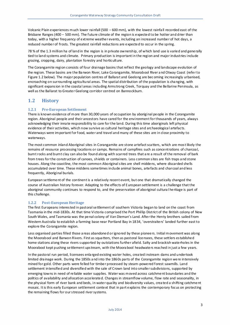
Barwon river upstream of Winche lsea, 1946. Source: CCMA
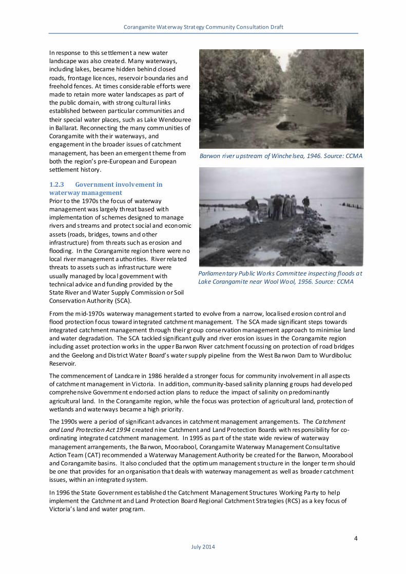
Parliamentary Public Works Committee inspecting floods at Lake Corangamite near Wool Wool, 1956. Source: CCMA
Corangamite Waterway Strategy Community Consultation Draft
5 July 2014
Figure 1.2 – Major basins of the Corangamite region
The Working Pa rty recommended a community-based service delivery model for catchment management, integrating the advisory roles of the current Catchment and Land Protection Boards, Salinity Implementation Groups, Regional Development Committees a nd Waterway Management Authorities, to create Ca tchment
Management Authorities.
The establishment of the Catchment Management Authorities in July 1997 represented the implementation of a co-ordinated waterway and integrated catchment management focus across the sta te with a major focus on project delivery through engagement and capacity building with local communities and stakeholders that remains in place to this day.
1.3 Waterways The CWS focuses on the management, protection and improvement of all waterways within the region. For the purposes of the strategy waterways are defined as:
All rivers and streams, including their floodplains (and floodplain wetlands) and estua ries.
Non-riverine wetlands, lakes and impoundments.
These waterways are spread throughout the region across four major drainage basins. These basins and their associated major wa terways are shown on Figure 1.2 and are as follows:
Moorabool Basin - includes the
Moorabool River and Hovells Creek, a small creek system that rises in the southern foothills of
the You Yangs and flows into Corio Bay.
Barwon Basin - includes the
Barwon River which rises in the northern slopes of the Otway Range and the Leigh River which begins in the central Victorian
uplands a round Ballarat, joining the Ba rwon a t Inverleigh.
Lake Corangamite Basin - a
landlocked system that includes the Woady Yaloak River and a number of small ephemeral creeks feeding Lake Corangamite and
other significant lakes and wetlands.
Otway Coast Basin - includes the
Curdies River which occupies the western section, the Gellibrand, Aire and numerous small coastal streams which occupy the central
Otways and the Erskine River, Spring and Thompson Creeks which flow through the eastern section.
1.3.1 Waterway Condition The condition of waterways within the Corangamite region has been assessed through a number of large scale monitoring prog rams, aimed at providing a summary of waterway condition across Victoria. These state-wide assessments include the Index of Stream Condition (ISC) and Index of Wetland Condition (IWC)
1.
1The Index of Estuary Condition was still in development at the time
of writing this strategy and has not been used to assess the condition of waterw3ays in the Corangamite region (refer belo w).
Corangamite Waterway Strategy Community Consultation Draft
6 July 2014
In general, these indices a re intended to assess the long-term condition of wa terways, rather than assessing condition a t a point in time or the results of specific management
interventions.
As a result, the condition scores at times do not always align with current conditions or the community’s understanding of condition. An example is the Anglesea estuary that has periodically suffered from fish death events due to naturally
occurring low pH water, which is still rated as being in good condition ref lecting its long term health.
Rivers and Creeks The statewide Index of Stream Condition (ISC) program is an integrated snapshot of the condition of rivers, creeks and estuaries, through the assessment of sub-indices relating to hydrology, physical form, streamside zone (riparian
vegetation), water quality and aquatic life (macroinvertebra tes).
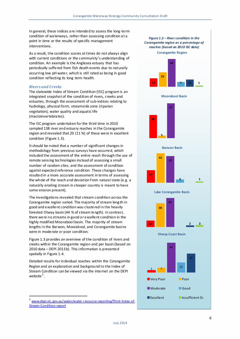
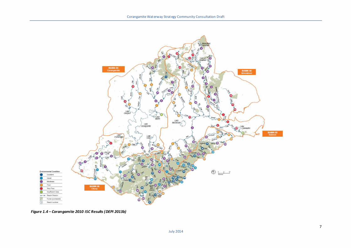
The ISC program undertaken for the third time in 2010 sampled 138 river and estua ry reaches in the Corangamite region and revealed that 20 (11 %) of these were in excellent
condition (Figure 1.3).
It should be noted that a number of significant changes in methodology from previous surveys have occurred, which included the assessment of the entire reach through the use of remote sens ing technologies instead of assessing a small
number of random s ites; and the assessment of condition against expected reference condition. These changes have resulted in a more accurate assessment in terms of assessing the whole of the reach a nd deviation from natura l state (e.g. a
naturally eroding stream in s teeper country is meant to have some erosion present).
The investigations revealed that s tream condition across the Corangamite region varied. The majority of stream leng th in good and excellent condition was clustered in the heavily
forested Otway basin (44 % of s tream length). In contrast, there were no streams in good or excellent condition in the highly modif ied Moorabool basin. The majority of stream lengths in the Barwon, Moorabool, and Corangamite basins were in moderate or poor condition.
Figure 1.3 provides an overview of the condition of rivers and creeks within the Corangamite region and per basin (based on 2010 data – DEPI 2013b). This information is presented spatially in Figure 1.4.
Detailed results for individual reaches within the Corangamite
Region and an explanation and background to the Index of Stream Condition can be viewed via the internet on the DEPI website 2.
2 www.depi.vic.gov.au/water/water-resource-reporting/Third-Index-of-Stream-Condition-report
Figure 1.3 – River condition in the Corangamite region as a percentage of
reaches (based on 2010 ISC data)
13
23
45
7 11 1
Corangamite Region
38
5
57
Moorabool Basin
17
41 37
4 1
Barwon Basin
10
38
47
2 3
Lake Corangamite Basin
3 7
46
15
29
Otway Coast Basin
Very Poor Poor
Moderate Good
Excellent Insufficient Data
Corangamite Waterway Strategy Community Consultation Draft
7 July 2014
Figure 1.4 – Corangamite 2010 ISC Results (DEPI 2013b)
Corangamite Waterway Strategy Community Consultation Draft
8
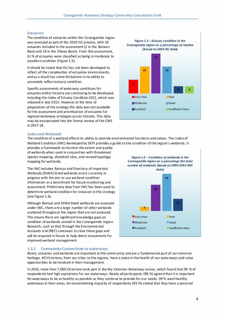
Estuaries The condition of estuaries within the Corangamite region was assessed as part of the 2010 ISC process, with 18 estuaries included in the assessment (2 in the Barwon Basin and 16 in the Otway Basin). From this assessment,
61 % of es tuaries were classified as being in moderate to excellent condition (Figure 1.5).
It should be noted that ISC has not been developed to reflect all the complexities of estuarine environments, and as a result has some limitations in its ability to
accurately reflect estua ry condition.
Specific assessments of waterway conditions for estuaries within Victoria are continuing to be developed, including the Index of Estuary Condition (IEC), which was released in late 2013. However at the time of
preparation of the strategy this data was not available for the assessment and prioritisation of estuaries for regional wa terway strategies across Victoria. This data may be incorporated into the formal review of the CWS in 2017-18.
Lakes and Wetlands The condition of a wetland affects its ability to provide environmental functions and values. The I ndex of
Wetland Condition (IWC) developed by DEPI provides a guide to the condition of the region’s wetlands. It provides a framework to monitor the extent and quality of wetlands when used in conjunction with threatened species mapping, shorebird sites, and revised typology mapping for wetlands.
The IWC includes Ramsar and Directory of Important Wetlands (DIWA) lis ted wetlands and is currently in progress with the aim to use wetland condition information as a benchmark for future monitoring and assessment. Preliminary data from IWC has been used to
determine wetland condition for inclusion in this strategy (see Figure 1.6).
Although Ramsar and DIWA listed wetlands are assessed under IWC, there a re a large number of other wetlands scattered throughout the region that a re not assessed.
This means there are significant knowledge gaps on condition of wetlands overall in the Corangamite region. Research, such as that through the Environmental Accounts trial (REF) continues to close these gaps and
will be required in future to help direct investments for improved wetland management.
1.3.2 Community Connections to waterways Rivers, estuaries and wetlands a re important to the community and are a fundamental pa rt of our common heritage. All Victorians, from our cities to the regions, have a stake in the health of our waterways and value opportunities to be involved in their management.
In 2010, more than 7,000 Victorians took part in the My Victorian Waterway survey, which found that 99 % of respondents had high aspirations for our waterways. Nearly all pa rticipants (98 %) agreed tha t it is important
for waterways to be as healthy as possible so they continue to provide for our needs. 99 % want healthy waterways in their areas. An overwhelming majority of respondents (96 %) s tated that they have a personal
Figure 1.5 – Estuary condition in the Corangamite region as a percentage of reaches
(based on 2010 ISC data)
11
22
33
22
6 6
Very Poor Poor
Moderate Good
Excellent Insufficient Data
Figure 1.6 – Condition of wetlands in the Corangamite region as a percentage the total number of wetlands (based on 2009-2010 IWC
data)
5
33
47
15
Very Poor Poor
Moderate Good
Excellent Insufficient Data
Corangamite Waterway Strategy Community Consultation Draft
9
responsibility to do the right thing for waterways and 83 % fe lt most personally connected to a local waterway, usually the s tretch of river or creek closest to where they live.
The Corangamite region has a s trong history of community-based na tural resource management, particula rly
through the Landca re movement and programs such as Waterwatch and the newly established Estua rywatch. These volunteers undertake activities such as engaging landholders and local people in na tural resource management, building partnerships, and undertaking on-ground works, monitoring and sharing knowledge. These community participation programs also provide importa nt opportunities for the Victorian government and regional agencies to deliver education and awareness raising programs on sustainable waterway
management and behaviours. Established community networks also deliver their own education and awareness raising activities tha t encourage broader adoption of sustainable land and water resources management by their peers.
1.3.3 Indigenous connection to waterways For Traditiona l Owners, land and waterways (also known as ‘Country’) are a part of who they are, just as they are part of it. Traditional Aboriginal culture revolved a round re lationships to the land and water and these relationships held physical, social, environmental, spiritual and cultural signif icance. Today, the land and its
waterways remain central to Traditional Owners’ cultural identity and aspira tions.
Traditional Owners have a dis tinct cultural perspective on water that relates to their identity and attachment to place, environmental knowledge, resource security and custodial responsibilities for managing Country. Water is the lifeblood for Country and waterways are the basis of many creation stories. Waterways are also a historical and ongoing source of food, fibre and medicine and an important place to camp, hunt, fish, swim and
connect with traditiona l culture and s tories, to ensure that they are passed on to future genera tions. Totem species, which connect people to Country and are a critica l part of cultura l beliefs, may also depend on healthy waterways.
Many Aboriginal cultural sites such as middens, initiation grounds, tools, fish traps, scar trees or other artefacts are located on or near waterways. Some significant s ites may have no observable features but a re
important for their intangible links to past places of spiritual or ceremonial significance, resources, trade, travel or stories.
Until recently, Victorian Traditiona l Owners have not been able to participate in waterway management at a level that appropria tely reflects their rights and interests. While Australian governments have ratified and
established a range of international, national and sta te policies in relation to the rights of Indigenous people, there is still much work to do with regard to the effective implementation of these policies. Victorian Traditional Owners have strong interests in healthy waterways and a right to be involved in regional waterway management on their Country. Future pa rtnerships with Traditional Owners will be more successful if they are supported by improved engagement processes and the provision of specific capacity building opportunities.
The CWS takes steps towards addressing this outcome for Traditional Owners through its development and delivery (refer to Section 3.2.2).