Embed Size (px)
Citation preview

Copperlode Falls Dam Emergency Evacuation Guide
KNOW WHERE TO GO
MY INFORMATION Name: Map No: Page No:
Property Address:
NOTE: This Emergency Evacuation Guide relates ONLY to announcements by the Early Warning System should there be a dam failure.

EARLY WARNING SYSTEMThe Early Warning System uses the latest technology delivered through nine Outdoor Warning Stations (sirens) – pictured left. These are speakers mounted to towers positioned throughout the Redlynch Valley from Crystal Cascades to Brinsmead.
These stations transmit automated warning signals and allow pre-recorded voice messages.
Further real-time alerts and information will be transmitted to residents and visitors via text messages, phone calls, radio broadcasting and social media messaging (note: some of these alerts require residents to ‘opt-in’ – see Additional Warnings, opposite for details).
SIREN SOUNDSIn the extremely unlikely event of a dam failure the siren will sound followed by the recorded voice message:
EMERGENCY – EMERGENCY – EVACUATE NOW – MOVE TO HIGHER GROUND
The Siren sound is not the standard emergency warning signal but a unique sound and message specific to a dam failure. On hearing this warning all residents and visitors in the area must immediately implement their emergency evacuation plan for their own safety, using this guide.
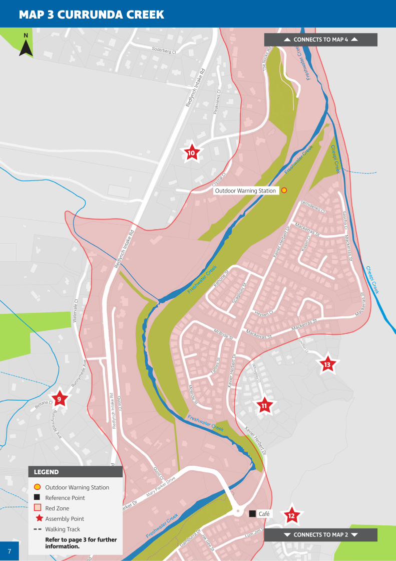
TAKE IMMEDIATE ACTIONIf you are located in the red zone and hear a notice to evacuate you must leave immediately make your way on foot to your nearest assembly point (marked with a star on the maps) – DO NOT DRIVE.
As the owner of Copperlode Falls Dam, and as part of its legislative requirements, Cairns Regional Council has an Emergency Action Plan (EAP). It is available on Council’s website at www.cairns.qld.gov.au/copperlodeEAP. The EAP explains roles and responsibilities, communication procedures and dam specific emergency scenarios including how people who live immediately downstream of the dam will be told about a dam emergency. This includes using an Early Warning System.
Copperlode Falls Dam Emergency Action Plan
1

Why you need an Emergency Evacuation PlanIn an emergency situation, everyone has a responsibility for their own safety.Residents and business owners in the Redlynch Valley and adjoining areas should use this guide to prepare, share and practise their own emergency evacuation plan.
WHAT AREAS ARE LIKELY TO BE AFFECTED? While the likelihood of a dam failure is extremely low, the consequences could be severe across a large area that extends from Crystal Cascades through the Redlynch Valley to Freshwater and Brinsmead (see map page 4 – Affected Area Maps). It is extremely important that if you live in the identified red zone, that you and your household understand the potential risk and know what to do if an evacuation is ordered, and most importantly know where to go.
People with disabilities living in the red zone are responsible for their own evacuation and should prepare a Personal Emergency Evacuation Plan.
HOW MUCH NOTICE WILL I HAVE? The sirens will alert residents and visitors in the area to evacuate only when a dam failure is imminent or has occurred. The safest thing to do on hearing the sirens is to take immediate action and move on foot to a previously identified assembly point on higher ground away from the red zone.
% THE LIKELIHOOD OF A DAM FAILURE? The likelihood of a dam failure is extremely low. Council has measures in place to ensure the integrity of the dam including detailed monitoring and inspection procedures and ongoing maintenance programs. This evacuation guide relates only to an unforeseen non-weather event that results in dam failure.
Cairns Regional Council also uses ‘Cairns Alert’ as a communication platform to issue alerts and warnings via SMS, email and voice. Resident details are obtained from the Council rates database for emergency alerts.Residents can also ‘Opt-in’ to the ‘Cairns Alert’ system for information about local disasters, and emergency events. The alerts are official communication from the Local Disaster Management Group. Warning SMS messages may also be received via the National Emergency Alert System. You do not need to subscribe to this service.Cairns Regional Council also provides the Cairns Disaster Management Dashboard at www.disaster.cairns.qld.gov.au which provides disaster news and intelligence via the internet.
ADDITIONAL WARNINGS IMPORTANT NOTEEvacuation warnings will only occur if the Copperlode Falls Dam wall has failed without warning or it is highly likely there is a dam failure in the near future.
2

Mark your evacuation route now
STEP
1 FIND YOUR PROPERTY ON MAP 1–10
Turn to this map and clearly mark your property.
STEP
2 IF YOUR PROPERTY IS IN THE RED ZONE
Identify your nearest assembly point (shown as a star) on the map. This will be in a higher area to your property. Make sure that the evacuation route to your assembly point is clear of potential hazards including streams. Practise walking this route.
Identify and mark on the map an alternative/secondary location and evacuation route in case the first becomes inaccessible.
STEP
3 IF YOUR PROPERTY IS NOT IN THE RED ZONE BUT CLOSE TO IT
Consider where you will go if you felt you needed to go to higher ground further away from the red zone, and mark this on the map.
Make sure that the route to this spot is clear of potential hazards including streams. Mark on the map the route you would take to this location. Practise walking this route.
Assembly Points have been identified on the maps. These are outside the red zone where emergency services can provide assistance after the immediate hazard threat has passed.
LISTEN FOR FURTHER ADVICE OR CALL 000 FOR HELP.
Following these steps now will save you time should the Early Warning System be activated and the Sirens and Evacuation Message sound.
3
ASSEMBLY POINTS

REDLYNCH VALLEY MAP
Map 2
Map 3
Map 4
Map 5
Map 7
Map 9
Map 6
Map 8
Map 10
Map 1
Copperlode Falls Dam4
Map 1 Crystal CascadesMap 2 Gamburra Drive ParkMap 3 Currunda CreekMap 4 Big4 Holiday ParkMap 5 Redlynch CentralMap 6 Freshwater Christian CollegeMap 7 Redlynch Park – Red Beret HotelMap 8 Redlynch Park – Freshwater ConnectionMap 9 Barron River – Lower Freshwater RoadMap 10 Barron River – Freshwater Connection
Areas outside the red zone may still be affected.
If your home or business is located anywhere in the red zone or close to it, you should be prepared and know what to do if the Copperlode Falls Dam Emergency Evacuation Plan is activated.
Discussing and sharing this plan with your family or household members is essential. Walk the proposed evacuation route now, so that everyone knows exactly where they need to go.
AFFECTED AREA MAPS

MAP 1 CRYSTAL CASCADES
Observation Deck
Crystal Cascades Carpark
Outdoor Warning Station
Outdoor Warning Station
Discussing and sharing this plan with your family, household members or business associates is essential for everyone’s safety. Taking the time to walk the proposed evacuation route now, so that everyone knows exactly where they need to go, will save time in an emergency.
Be prepared and know where to go
KEEP LISTENING During and after an evacuation more information will be broadcast on local radio, TV, websites and social media. Advice and instructions will be issued by emergency services. Call for help if you need it (see Emergency Contacts back page).
IN THE EVENT OF AN EVACUATION On hearing sirens, take immediate action and move on foot to your previously identified assembly point. Stay in this high ground location until advised it is safe to leave. It may not be safe to return to your property. Keep out of flooded areas even if you know them well.
5
CONNECTS TO
MAP 2
Outdoor Warning Station
Reference Point
Red Zone
Assembly Point
Walking Track
Refer to page 3 for further information.
LEGEND
1
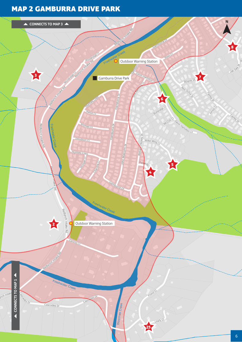
Gamburra Drive Park
Outdoor Warning Station
Outdoor Warning Station
MAP 2 GAMBURRA DRIVE PARK
CONNECTS TO MAP 3
CO
NNEC
TS T
O M
AP 1
8
7
6
5
4
2
25
3
6
Café
CONNECTS TO MAP 2
7
MAP 3 CURRUNDA CREEK
10
911
13
12
Outdoor Warning Station
CONNECTS TO MAP 4
Outdoor Warning Station
Reference Point
Red Zone
Assembly Point
Walking Track
Refer to page 3 for further information.
LEGEND

Redlynch Equestrian Park
BIG4 Holiday Park
Robb Reserve
Chirio Drive Park
CONNECTS TO MAP 3
8
MAP 4 BIG4 HOLIDAY PARK
15
14
Outdoor Warning Station
CONNECTS TO MAP 5 & 6

9
MAP 5 REDLYNCH CENTRAL
CONNECTS TO MAP 7
Redlynch State College
St Andrew’s Catholic College
Redlynch Central Shopping Centre
Redlynch Central Sports Stadium
CONNECTS TO MAP 4
26
Outdoor Warning Station
Outdoor Warning Station
Reference Point
Red Zone
Assembly Point
Walking Track
Refer to page 3 for further information.
LEGEND

10
MAP 6 FRESHWATER CHRISTIAN COLLEGE
CONNECTS TO MAP 8
Goomboora Park
Glenoma Park
Cool Waters Holiday Park
Freshwater Christian College
Bella Vista Shopping Centre
CONNECTS TO MAP 4
20
1817
Outdoor Warning Station

Red Beret Hotel
Redlynch Skate Park
Redlynch Sports Stadium
11
MAP 7 REDLYNCH PARK – RED BERET HOTEL
CONNECTS TO MAP 5
CONNECTS TO MAP 9
21
22
16
Outdoor Warning Station
Outdoor Warning Station
Reference Point
Red Zone
Assembly Point
Walking Track
Refer to page 3 for further information.
LEGEND

Freshwater Connection
Freshwater Christian College
12
MAP 8 REDLYNCH PARK – FRESHWATER CONNECTION
CONNECTS TO MAP 6
CONNECTS TO MAP 10
23
24
19

Peace Lutheran College
13
MAP 9 BARRON RIVER – LOWER FRESHWATER ROAD
CONNECTS TO MAP 7
27
Outdoor Warning Station
Reference Point
Red Zone
Assembly Point
Walking Track
Refer to page 3 for further information.
LEGEND

14
MAP 10 BARRON RIVER – FRESHWATER CONNECTION
CONNECTS TO MAP 8

PO Box 359 QLD 48701300 69 22 47
[email protected] www.cairns.qld.gov.au
DISCLAIMER NOTE: While every care is taken to ensure the accuracy of this data, Cairns Regional Council makes no representations or warranties about its accuracy, reliability, completeness or suitably for any particular purpose and disclaims all responsibility and all liability (including without limitations, liability in negligence) for all expenses, losses, damages (including indirect or consequential damages) and costs which you might occur as a result of the data being inaccurate or incomplete in any way or for any reason.
EMERGENCY CONTACTSPolice Fire Ambulance Emergencies only
000
State Emergency Service (SES) 13 25 00
Ergon EnergyFor power emergencies and urgent hazardous situations
13 22 96
Road and Traffic Conditions (TMR) 13 19 40
Health and Hospital Information (QH) 13 HEALTH (13 43 25 84)
Water Supply Emergencies (CRC) 1300 69 22 47
Non-Emergency Situations Police: 13 14 44 Ambulance: 13 12 33
CAIRNS DISASTER DASHBOARD www.disaster.cairns.qld.gov.au
MORE INFORMATION
www.cairns.qld.gov.au/copperlodeEAP
COUNCIL CONTACTS
Customer Service Centres 1300 69 22 47
Disaster Coordination Centre 4044 3377
September 2021