Embed Size (px)
Citation preview
Copeland Creek Master PlanSonoma State University
Draft 11-7-01 Acknowledgements
COPELAND CREEK MASTER PLAN
SONOMA STATE UNIVERSITY
Prepared for the Campus Reengineering Committee, chaired by Vice President ofAdministration and Finance and Chief Financial Officer, and the Campus Planning
Committee, chaired by President Ruben Armiñana.
Prepared by Quadriga Landscape Architecture and Planning, Inc.
In consultation withCOPELAND CREEK ADVISORY COMMITTEE
Deborah Gannon DuVall (Chair) .......SSU Director of Facilities PlanningBruce Walker.....................................SSU Capital Planning, Design /ConstructionNate Johnson .....................................SSU Chief of Police ServicesCraig Dawson....................................SSU Director, EH&SPhil Northen ......................................SSU Professor, BiologyTom Jacobson....................................SSU Associate Professor, ENSPDavid Stokes .....................................SSU Assistant Professor, ENSPKaren Tillinghast ...............................SSU Lead Gardener, Landscape ServicesVicki Pannell .....................................SSU Work Control System AdministratorKara Heckert .....................................SSU StudentBrian Turner ......................................SSU StudentSteve Hernandez................................SSU StudentBill Cox, (ex officio)..........................California Dept. of Fish and GameAndrew Jensen, (ex officio) ...............North Coast Regional Water QualityBill Mastick.......................................Quadriga Landscape ArchitectureJane Marx..........................................Quadriga Landscape Architecture

Copeland Creek Master PlanSonoma State University
Draft 11-3-01 Table of Contents
TABLE OF CONTENTS
LIST OF FIGURES ........................................................................................ 1
INTRODUCTIONPurpose ................................................................................................. 2The Creek Setting.................................................................................. 3-4
GUIDING PRINCIPLES AND VISIONGuiding Principles................................................................................. 5Sonoma State University Copeland Creek Restoration Policy ................ 6-7
SUMMARY OF GOALS ............................................................................... 8
IMPLEMENTATION PLAN SUMMARY…………………………………..9-14
GOALS, POLICIES AND OBJECTIVES: No. of pages
GOAL 1: ‘Maintain and Protect Native Biodiversity’.................................. 1-10Oversight, Administration and MonitoringGeneral Routine MaintenanceFuture Development
GOAL 2: ‘Restore’......................................................................................... 1-4Vegetation and WildlifeAppendices to Goal 2
GOAL 3: ‘Increase Community Awareness’ ................................................ 1-9Recreation and UseCirculationAesthetics
GOAL 4: ‘Increase Knowledge and Understanding’ ................................... 1-4Educational Outreach and Research
GOAL 5: ‘Improve Stormwater Management’ ............................................ 1-10
APPENDICESHabitat InventoryFeral Cat Policy
GLOSSARY OF TERMS ...............................................................................

Copeland Creek Master PlanSonoma State University
Draft 11-3-01 List of FiguresPage 1
LIST OF FIGURES
GOAL 1 Maintain and Protect Native BiodiversityApplication for conducting Activity withinthe Copeland Creek Corridor .......................................................... Goal 1-Pages 5-6
General Routine Maintenance Zones and Guidelines ...................... Goal 1-Pages 7-10
GOAL 2 Restore Native SpeciesVegetation Planning ....................................................................... Figure 2A.e.
List of Species Suitable to Copeland Creek Corridor ...................... Goal 2-Appendix
Native Plant Garden Area Vegetation Inventory ............................. Goal 2-Appendix
Sonoma State Bird ListCopeland Creek / Native Plant Garden Area
By Rebecca Olsen............................................................... Goal 2-Appendix
Sensitive Species Survey for Music Center AreaBy Michael Fawcett, Ph.D., Ecologist ................................. Goal 2-Appendix
Special Status Species Tables fromSSU Master Plan EIR ..................................................................... Goal 2-Appendix
GOAL 3 Increase Community AwarenessProposed Pathway Widths, Surfaces and Circulation ...................... Figure 3A.a.
Public Access, Observation and Aesthetics..................................... Figure 3A.b.Observation and Sitting Areas,Site Furnishings, Signage
GOAL 5 Improve Stormwater ManagementStorm Drain Outfalls and Bank Stabilization Locations .................. Figure 5A.
Open Drainage Channel OpportunitiesModified Storm Drain Outlet Opportunities100 year water surface elevation
Bank Stabilization Concepts ........................................................... Figure 5A.a.
Storm Drain Outlet Alternative....................................................... Figure 5A.d.Storm Drain Outlet Alternative....................................................... Figure 5A.e.
AppendixStream Habitat Inventory (Spring 2001)
( Per Level IV protocol, ‘California Salmonid Stream Habitat RestorationManual’, Third Edition, January 1998, published by CA Dept. of Fish andGame )

Copeland Creek Master PlanSonoma State University
IntroductionDraft 11-7-01 Page 2
INTRODUCTION
PURPOSEThe Copeland Creek Master Plan is a working document establishing a broad “blueprint”of guiding principles, goals, and actions for development and preservation of theCopeland Creek Buffer Zone located on the Sonoma State University campus. TheBuffer Zone was designated during a major revision of the Campus Facilities Master Planand its supporting Environmental Impact Report certified and approved by the Board ofTrustees in May 2000. The Buffer Zone, which originates at the top of the creek bankand extends laterally along the creek, has been designated to 150 feet on the north side ofthe creek and to include the Native Plant Garden on the south side of the creek.Additionally, where existing development allows, mitigation for any impact to the creekshould be considered within a minimum of 150 feet south of the creek as well. ThisMaster Plan contains policies and physical improvements to guide restoration, recreation,and opportunities for the creek to become an amenity as an educational resource.
The Sonoma State University Copeland Creek Master Plan was adopted by the SonomaState University Campus Planning Committee at the _____________ meeting, 2001.
The Master Plan is a statement of community principles and policy, not a commitment offinancial resources. Implementation of the plan goals will be contingent on the continuedinvolvement of the Copeland Creek Committee, under the chairmanship of the Directorof Planning, acting as stewards of the Creek to ensure that creek activities and outreachefforts conform to Master Plan policies. This committee is made up of student, staff, andfaculty. It also consults closely with the appropriate external agencies with jurisdiction inthe creek environment, such as the State Regional Water Quality Board and theDepartment of Fish and Game. This committee will make recommendations to theUniversity President for approval and implementation.
Although responsible for development on campus property, the plan must be viewed incontext of the larger Russian River watershed, and Copeland Creek upstream anddownstream.
The plan contains policies that range from design criteria to protect the nativebiodiversity and ecological processes to general routine maintenance and flood controltechniques.

Copeland Creek Master PlanSonoma State University
The Creek SettingDraft 11-7-01 Page 3
THE CREEK SETTING
Sonoma State University is located in southern Sonoma County adjacent to the city ofRohnert Park, approximately 50 miles north of San Francisco. The 269-acre campus isbisected by a segment of Copeland Creek. The campus site is located in the easternportion of the Laguna de Santa Rosa watershed, which eventually flows into the RussianRiver. The Laguna de Santa Rosa receives a portion of its water from several drainagesand creeks on Sonoma Mountain, including Copeland Creek, which flows east to westthrough the campus, and Hinebaugh Creek, which flows east to west approximately one-third mile north of the campus. Copeland Creek is a steelhead-bearing stream withsignificant habitat and ecological value. It consists of a semi-natural channel within thecampus. Downstream, it is a constructed (deepened and/or widened) channel.
The currently undeveloped portion of the campus north of Copeland Creek slopes anddrains overland toward the northwest, away from Copeland Creek and toward roadsideditches along Rohnert Park Expressway. These ditches convey the runoff into twoculverts under Rohnert Park Expressway, which, via drainage ditches ultimatelydischarge into Hinebaugh Creek. The developed area, consisting of the main campuslocated south of Copeland Creek, currently directs storm water flows to Copeland Creek.
At the time of its establishment in the 1960’s the SSU campus was surrounded by ruralagricultural land approximately one to one-half mile from the small cities of RohnertPark and Cotati. These cities have since grown considerably, particularly eastwardtoward the campus. The Rohnert Park city limit is currently located at the western borderof the campus. The segment of Copeland creek traverses the campus east to west forapproximately 3,600 feet. This intermittent stream and associated riparian habitatprovides a significant repository of biodiversity and ecological services as well as anatural open space amenity to the campus.
The Copeland Creek segment that crosses the campus represents a bridge between theurban creek setting in the city of Rohnert Park and the rural agricultural properties acrossPetaluma Hill Road to the east of the campus.
Over the years interested groups such as Friends of Copeland Creek and the SSUEnvironmental Studies Department and Biology Department have conducted educationaland service projects to plan and restore the segment of Copeland Creek riparian zonesouth of the creek.

Copeland Creek Master PlanSonoma State University
The Creek SettingDraft 11-7-01 Page 4
The Sonoma County Water Agency, in association with private property owners iscurrently implementing a Copeland Creek restoration project east of the campus betweenRoberts/Pressley Road and Petaluma Hill Road. The purpose of the project is to restorethis section of Copeland Creek to pre-cattle grazing conditions by eliminating disturbancefactors within the riparian zone and allowing the creek to reestablish its historicalpatterns. Previous heavy cattle grazing in this area has reduced the quality of the riparianhabitat, which at one time was a corridor of willow and alder vegetation. Thisdegradation of stream bank and vegetation from grazing has contributed to excessivesedimentation of gravel and silt downstream of Petaluma Hill Road, including throughthe SSU campus as well as the lower Creek reaches through the City of Rohnert Park.The campus is anticipating improved sediment conditions on their stretch of the creekonce the restoration project is established.
Restoration of the campus section of Copeland Creek, along with the Sonoma CountyWater Agency’s restoration project, will, when native plants are mature, yield a creek thatis a relatively intact native riparian system from its headwaters to the downstream side ofthe SSU campus.

Copeland Creek Master PlanSonoma State University
Guiding PrinciplesDraft 11-7-01 Page 5
GUIDING PRINCIPLES
The Copeland Creek Master Plan is based on the following principles:
1. Copeland Creek should be viewed as an ecosystemwith both in-stream and terrestrial components havingcharacteristic physical structure, species, diversity,ecological processes and dynamics as well as servicesto people.
2. Copeland Creek and its habitat within the boundariesof the Sonoma State University campus should beviewed and treated in the context of the entireCopeland Creek watershed.
3. Copeland Creek is surrounded by both natural andurbanized areas along its length; the policies andpractices of the Copeland Creek Master Plan shouldrecognize the challenges and opportunities presentedby this natural/urban interface.
4. Copeland Creek presents an important opportunity forthe University to demonstrate to the community atlarge a model of development that protectsbiodiversity and ecological integrity while furtheringhuman values and human interaction with the naturalenvironment.
5. Copeland Creek should be valued for the educational,recreational and aesthetic benefits it provides theUniversity.
“….we are challenged as mankind has never been challenged before toprove our maturity and our mastery, not of nature, but of ourselves.”
Rachel Carson

Copeland Creek Policy
SONOMA STATEUNIVERSITY
WEB FORMAT
Recommended By: Campus Planning Committee
Approved: Ruben Armiñana, President
Date of Issue: May 15, 2000Effective Date: May 15, 2000Contact Office: Facilities Services
POLICY:
Copeland Creek
1. Purpose
Sonoma State University hereby adopts as campus policy the following strategies for the monitoring, maintenance, development, restoration, and improvement of that portion of Copeland Creek adjacent to and/or within the boundaries of its land(s):
A. The University is dedicated to the maintenance and enhancement of the native biodiversity of Copeland Creek.
B. The University will develop measures to protect indigenous plant and animal species native to the Copeland Creek habitat.
C. The University will both maintain, and where feasible, develop programs to restore native plant communities within the Copeland Creek habitat.
2. Procedures
http://www.sonoma.edu/uaffairs/policies/copelandcreek.htm (1 of 3) [2/11/2002 9:18:05 AM]

Copeland Creek Policy
A. The Director of Campus Planning is hereby designated with responsibility for developing and overseeing programs designed to implement the purposes identified above.
B. The Director of Campus Planning will work with campus consulting landscape architects in the development of site plans and other proposals which might impact Copeland Creek to insure their consistency with the purposes identified above.
C. The Director of Campus Planning will initiate and carry out appropriate consultation with state and/or federal agencies, including but not limited to the State of California, Department of Fish and Game, whose mandates include issues related to the monitoring, maintenance, development, and/or restoration of Copeland Creek.
D. The Director of Campus Planning is hereby designated by the President of the University as the single and primary contact person for information and requests by persons wanting to conduct activities within and/or adjacent to the boundaries of Sonoma State University that might infringe upon Copeland Creek. All persons and organizations wanting to conduct such activities are required to notify the Director of Campus Planning, who may approve, limit, or disallow the requested activity. The Director shall contact the Department of Fish and Game (DFG) when the Director believes proposed activities may require consultation with or approval by DFG.
3. Copeland Creek Advisory Committee
To advise and assist the Director of Campus Planning in the performance of the duties identified above, the University hereby establishes the Copeland Creek Advisory Committee.
A. The President shall appoint a committee composed of the following members:
1. The Director of Campus Planning, Chair
2. The Campus Architect
3. The Chief of Police Services
4. The Director of Environmental Health and Safety
5. The Director of Campus Landscaping
http://www.sonoma.edu/uaffairs/policies/copelandcreek.htm (2 of 3) [2/11/2002 9:18:05 AM]

Copeland Creek Policy
6. The campus' Consulting Landscape Architect
7. Three (3) members of the Faculty recommended by the Academic Senate
8. Three (3) Student members recommended by the Associated Students
9. Two (2) Staff members
Ex-Officio, as Consultant to Committee:
One (1) Representative from the California Department of Fish and Game
B. The committee is charged with the following responsibilities:
1. Develop recommendations for and assist in the implementation of a program to monitor and study the quality of the habitat and resources of Copeland Creek within and adjacent to the boundaries of Sonoma State University.
2. Review monitoring of the habitat and physical boundaries of Copeland Creek to provide information on the impact and effect of development and restoration activities within the Copeland Creek zone.
Order Form for an Official Copy of this University Policy
Related Links:
Back to TopBack to Policy Home Page and Search FeaturesBack to SSU
Updated May 16, 2000 by [email protected]
http://www.sonoma.edu/uaffairs/policies/copelandcreek.htm (3 of 3) [2/11/2002 9:18:05 AM]

Copeland Creek Master PlanSonoma State University
Goal SummaryDraft 11-7-01 Page 8
GOALS
The Copeland Creek Master Plan Goals are:
GOAL 1: Maintain and protect the native biodiversity, ecological processes, andconditions of Copeland Creek and its associated in-stream, riparian,transitional, and upland habitats.
GOAL 2: Restore native species, biotic communities, ecological processes, andconditions in Copeland Creek and its associated in-stream, riparian,transitional, and upland habitats.
GOAL 3: Increase community awareness and appreciation of Copeland Creek andits associated habitats as an important campus amenity by providingopportunities for public access, recreation, and education, in forms notinconsistent with Goals 1 and 2.
GOAL 4: Increase knowledge and understanding of native biodiversity, ecologicalprocesses, ecological restoration, and human impacts in and aroundriparian ecosystems in general, and Copeland Creek in particular, throughresearch and educational activities undertaken by Sonoma State Universityfaculty and students, provided these activities are not inconsistent withGoals 1 and 2.
GOAL 5: Maintain and improve hydraulic function of Copeland Creek in a mannerthat combines flood control requirements with ecological restoration andwater quality considerations.
This document outlines goals, policies and implementation. Policies and implementationmeasures that support the goals are contained within each goal section.

Page 9
COPELAND CREEK IMPLEMENTATION PLAN SUMMARY
Policy Implementation Measure Responsible Party Timeline1A.a Prepare a General Routine Maintenance Guideline Director of Planning/Ecological Specialist Complete
Supervisor of Landscaping
1A.b Prepare maintenance issues related to hydraulic Director of Planning/Ecological Specialist Completefunction of the creek.
1A.c Update maintenance guidelines yearly. Director of Planning/Ecological Specialist Spring
1B.a Procedures for administration and oversight ofactivity within creek corridor Director of Planning/Ecological Specialist On-going
1B.b Define roles regulating activity within creek corridor. Creek Master Plan Complete
1C.a Regulate development to protect and engage corridor Director of Planning/Ecological Specialist On-going
1C.b Regulate development to maintain a 150’ setback Director of Planning/Ecological Specialist On-going
1C.c Encourage neighboring property owners tomaintain 150’ setback Director of Planning/Ecological Specialist On-going
1C.d Encourage future campus master planningto coordinate with Copeland Creek Master Plan Director of Planning/Ecological Specialist On-going
1D.a Limit construction to avoid impacts to nesting birds Director of Planning/Ecological Specialist On-going
1D.b Conduct pre-construction surveys to minimize impactsto special status plants and animals Director of Planning/Ecological Specialist On-going

Page 10
COPELAND CREEK IMPLEMENTATION PLAN -2-Policy Implementation Measure Responsible Party Timeline
2A.a Inventory vegetation and wildlife species Creek Committee/Academic Depts. On-going
2A.b Identify a central location for maintaining records Director of Planning/Ecological specialist On-going
2A.c Obtain aerial photographs of the creek corridor Director of Planning Every 5 years
2A.d Identify and remove exotic species and replacewith native species Director of Planning/Creek Committee On-going
2A.e Develop guidelines and plant communities forrestoration Creek Master Plan/Creek Committee On-going
2A.f Monitor plant survival and development Creek Committee/Director of Planning On-going
2A.g Include restoration and research as part of curriculum Creek Committee On-going
2A.h Identify plant and animal special status species Creek Master Plan/Creek Committee Yearly
3A.a Identify and develop pedestrian paths in corridor Creek Committee/Director of Planning 2002/03
3A.b Develop locations for creek overlooks, observationand access to creek channel Creek Committee/Director of Planning 2003/04
3A.c Identify vehicular routes within the creek zone Creek Master Plan Complete
3A.d Increase accessibility for handicapped users Director of Planning 2003/04

Page 11
COPELAND CREEK IMPLEMENTATION PLAN -3-Policy Implementation Measure Responsible Party Timeline
3A.e Identify areas to be excluded from public accessibility Creek Master Plan Complete
3B.a Increase opportunity for bicycle use on the south bank Director of Planning 2004/05
3C.a Identify and encourage compatible recreation, programsevents in the creek zone Creek Master Plan Complete
3C.b Develop procedure/guidelines for staging functions in zone Director of Planning/Creek Committee On-going
3D.a Define aesthetic quality of Creek Protection Zone Creek Master Plan Complete
3D.b Restore native species and their habitat Creek Master Plan Complete
3D.c Minimize human-generated noise near creek zone Director of Planning/Ecological Specialist On-going
3D.d Prepare design guidelines and standards for all signage Creek Committee 2002/03
3D.e Provide trash containers at strategic locations Director of Planning/Ecological Specialist 2002/03
3D.f Implement restrictions governing domestic animals Environmental Health and Safety 2001/02
3E.a Install a coordinated system of signs andinterpretive/educational displays along trails Creek Committee/Director of Planning 2003/04
3E.b Identify funding sources for signage Creek Committee 2002/03
3E.c Encourage public education regarding creek protection Creek Committee On-going

Page 12
COPELAND CREEK IMPLEMENTATION PLAN -3-Policy Implementation Measure Responsible Party Timeline3F.a Identify lighting requirements along corridor Creek Committee 2002/03
4A.a Prepare a General Research and Restoration Policy Creek Committee 2002/03
4A.b Oversee and coordinate research and restoration efforts Creek Committee 2002/03
4A.c Procedure for submitting proposal for research Creek Master Plan Completed
4A.d Submit report of research findings to Creek Committee Researcher On-going
4A.e Monitor research and restoration projects Researcher On-going
4B.a Develop a monitoring plan for creek zone Creek Committee 2002
4B.b Conduct periodic qualitative monitoring Creek Committee On-going
4C.a Development management implications of studies Researcher On-going
4C.b Schedule period meetings of the Creek Committee Director of Planning On-going
4C.c Maintain contact with watershed constituent groups Creek Committee On-going
4D Encourage outside funding of research Creek Committee On-going
4E.a Prepare an educational policy documentdescribing acceptable activities in creek zone Creek Committee 2002/03
4E.b Publicize and distribute the policies and rulesregarding activities in the creek zone Creek Committee/Director of Planning On-going

Page 13
COPELAND CREEK IMPLEMENTATION PLAN -5-Policy Implementation Measure Responsible Party Timeline4E.c Instructors wishing to conduct a class assignment
must notify the Director of Planning and followMaster Plan procedure Applicant On-going
4E.d Record educational use in the creek zone. Creek Committee/Director of Planning On-going
4F.a Communication with interested local interest groupsand responsible agencies Director of Planning/Ecological Specialist On-going
4F.b Continue to identify and develop opportunities foreducation and outreach Creek Committee On-going
5A.a Use environmentally sensitive erosion control techniques Director of Planning/Responsible Agencies On-going
5A.b Outline concept solution for sedimentation problemsat existing storm drain outfalls Director of Planning/Creek Committee 2002/03
5A.c Provide storm water runoff guidelines for newdevelopment Director of Planning/Creek Committee 2002/03
5A.d Construct sediment filters and traps for future projects Director of Planning On-going
5A.e Future roof drainage encouraged to drain to vegetatedswale networks Director of Planning On-going
5A.f Carry out re-vegetation, seeding and mulching projects Director of Planning/Ecological Specialist On-going
5A.g Establish acceptable methods for emergencystabilization or flood control measures Director of Planning/Responsible Agencies On-going

Page 14
COPELAND CREEK IMPLEMENTATION PLAN -6-Policy Implementation Measure Responsible Party Timeline
5A.h Monitor hydraulic capacity, bank stabilization, erosion Director of Planning/Creek Committee On-going
5B.a Establish a MOU with responsible agencies for permitted Director of Planning Spring 2002maintenance practices.
5C.a Notify responsible agencies of Creek Meetings Director of Planning On-going
5C.b Identify procedures and reporting requirements Director of Planning 2002/03
5C.c Maintain contact with watershed constituent groups Director of Planning/Ecological Specialist On-going

Draft 11-3-01 Goal 1-Page 1Application
GOAL 1:Maintain and protect the native biodiversity, ecological processes, andconditions of Copeland Creek and its associated in-stream, riparian,
transitional, and upland habitats.
All five goals of the Master Plan generally relate to creek and watershed protection. Policiesidentified under this goal specifically address general routine maintenance, management andadministration, and future development. However, policies related to Goals 2,3 and 5 are closelyrelated and provide additional resources and guidelines toward maintenance and protection ofCopeland Creek.
POLICY 1A: PROVIDE ACCEPTABLE METHODS FOR MAINTENANCE IN ANDAROUND THE CREEK.
Implementation Measure:
1A.a. Prepare a ‘General Routine Maintenance Guidelines’ document.In order to reduce conflicts inherent in general maintenance in and around theCreek area relative to creek protection, a document has been prepared for SSUmaintenance personnel outlining acceptable routine maintenance practices. Thisdocument is part of the Master Plan and shall be kept in the Maintenance Yardbuilding for ease of reference.
Reference attached ‘General Routine Maintenance’ document on pages 5-6 of thisgoal section.
Implementation Measure:
1A.b. Prepare general guidelines for larger maintenance issues related to hydraulicfunctions of the Creek.
Reference Goal 5, Policy 5B, pages 5-8 which is part of this Creek Master Planand shall also be kept in the Maintenance Yard building for ease of reference.
Implementation Measure:
1A.c. Update ‘General Routine Maintenance Guidelines’ document on a yearly basis.The Director of Facilities Planning shall be responsible for coordinating an updateof the document on a yearly basis with the Maintenance Department and theCreek Committee. This update will be dated and inserted into the CopelandCreek Master Plan and also kept in the Maintenance Yard building.

Draft 11-3-01 Goal 1-Page 2Application
Implementation Measure:
1A.d. Provide creek protection instruction to SSU maintenance personnel yearly.The Director of Facilities Planning and the Director of Maintenance shall beresponsible for coordinating a yearly meeting with maintenance personnel toreview acceptable maintenance practices within the Creek Buffer Zone.
POLICY 1B: MANAGE AND REGULATE ACTIVITY WITHIN THE CREEKCORRIDOR IN CONFORMANCE WITH THE CREEK MASTER PLAN.
Implementation Measure:
1B.a. Require adherence to established procedures for administration and oversight ofactivity within the Creek corridor.
Any activity involving construction, planting, restoration, research, recreation,plant removal, or social functions has the potential for disturbing habitat, wildlifeand creek restoration efforts. Therefore, organizers of any of these activitieswithin the Creek Buffer Zone shall plan for, and conform to the followingprocedures:
1. The Director of Facilities Planning shall be notified one month in advance ofthe event with an application form.
2. The activity shall not occur until approved by the Director of FacilitiesPlanning and the Creek Committee.
3. The application will be approved based upon the activity’s conformance withthe Copeland Creek Master Plan.
4. The application shall outline activities proposed within the Creek BufferZone, time and date, provisions for clean-up, provisions for Creek protection,location depicted by mapping, person responsible, and monitoring proposal.Base mapping and applications for this purpose are available from theDirector of Facilities Planning.
5. A sample application is attached to this section for reference, pages 5-6.6. Low impact activities occurring within the Creek Buffer Zone, such as bird
watching, do not require a permit, however, it is required that these lowimpact activities occur on the existing trails and overlooks only.
Implementation Measure:
1B.b. Define roles and responsibilities for regulating activity within the CreekProtection Zone.
Ensure compliance with the various aspects of this Master Plan and the SonomaState University blue paper policy entitled “Copeland Creek”. This includesclearly defining roles and responsibilities and adhering to all external regulatoryrequirements.Roles and responsibilities:
1. Environmental Health and Safetya. Responding and managing any hazardous spills.b. Liaison to oversight regulatory agencies.
2. Director of Facilities Planning and the Creek Committee

Draft 11-3-01 Goal 1-Page 3Application
a. Approves all events and other activities within the Copeland CreekBuffer Zone.
b. Final approval for plantings and other restorations.3. Customer Service
a. Places work order for fallen trees or other hazards identified.4. Landscaping Department
a. Serves as advisory expert to Director of Facilities Planning and theCreek Committee, which provides recommendations on plantinginventory, removal and other landscape related issues.
5. Restoration/Planting installersa. Any individuals or groups that wish to plant native plants or take other
restoration action within the Creek Buffer Zone must complete therequired application form and receive approval from LandscapingDepartment, the Director of Facilities Planning and the CreekCommittee prior to commencing any work. As part of this application,plant installers must also outline provisions on the form for the wateringand care of any new vegetation until the plants become established.
POLICY 1C: ENCOURAGE NEW DEVELOPMENT TO PROTECT AND RESTORETHE ECOLOGICAL INTEGRITY OF THE CREEK CORRIDOR.Also refer to Goal 5, for future development guidelines regarding storm waterrunoff, sedimentation. ( Goal 5-Pages 3-5 )
Implementation Measure:
1C.a. Regulate new and redevelopment on campus that will protect and engage withthe Creek corridor.
Design of buildings along the Creek corridor should take advantage of the creekamenity. By designing buildings that generate activity, access, and views towardthe Creek, rather than ‘backing-on’ to the Creek, the corridor will not be viewedas a leftover space, but as an integral part of the University. The activities to beencouraged should not be inconsistent with Goals 1 and 2.
Implementation Measure:
1C.b. Regulate new and redevelopment on campus to maintain a 150’ setback from thetop of bank.
Redevelopment of existing buildings, structures, roads and walkways on the southbank within 150’ of the top of bank will be subject to review withrecommendations relative to Creek compatibility by the Facilities ServicesPlanning Director and the Creek Committee. Setbacks for redevelopment workwill vary depending upon existing conditions at various points along the Creek. A150’ setback should be enforced for future campus development to allow forpotential future natural changes in channel course and dimensions, vegetationsuccession, erosion and flooding relative to structure proximity and protection.Where native plantings are narrower than 150 feet on the south side of the creek,all plantings shall be native species to complete the full 150-foot zone. This willexpand the width of the riparian and upland habitat associated with the creek aswell as help insulate the creek zone from exotic species invasion. As native

Draft 11-3-01 Goal 1-Page 4Application
plantings are established to 150 feet from the creek on the developed campus,exotic species shall be eliminated in this zone.
Implementation Measure:
1C.c. Encourage property development adjacent to Copeland Creek, but not owned bythe University to occur outside of the creek buffer.
The undeveloped fields between Copeland Creek and the Rohnert ParkExpressway just west of the North Property Parking Lots, is slated for residentialdevelopment according to the City of Rohnert Park General Plan. The Universitywill encourage the developer of that property to continue a setback established forthe Music Center project setback of 150’ from the top of bank to any structure.
Implementation Measure:
1C.d. Encourage future campus master planning efforts to coordinate with the goalsoutlined in the Copeland Creek Master Plan.
The Director of Facilities Planning shall make the Copeland Creek Master Plan,and it’s implementation plan, a part of future campus master planning endeavors.
POLICY 1D: PROTECT EXISTING WILDLIFE DURING CONSTRUCTION WITHINTHE CREEK CORRIDOR.
Implementation Measure:
1D.a. Limit construction schedules to avoid impacts to migrating, nesting birds.Construction activities between tops of banks, within the Copeland Creek BufferZone shall be limited to the period between August 1 through October 15.See note 1D.b
Implementation Measure:
1D.b. Conduct pre-construction surveys to avoid or minimize impacts to specialstatus* plants and animals.
To protect special status species, and species not listed but potentially threatenedby construction, conduct pre-construction surveys in and near the areas ofconstruction. If special status animal species, or species not listed but potentiallythreatened by construction are found, avoidance measures shall be taken, or, theyshall be relocated out of the construction zone to adjacent, appropriate habitats. Aqualified biologist shall do this work.
Note: Construction projects will require CEQA review and required State and Federalagency permits, which may outline alternative mitigation.
Request Date:_____________

Draft 11-3-01 Goal 1-Page 5Application
Event/Activity Start Date(s):_____________Event/Activity End Date(s):_____________
Anticipated number of attendees:_____________
APPLICATIONFOR CONDUCTING ACTIVITY
WITHIN THECOPELAND CREEK PROTECTION AND BUFFER ZONES
1. Description of proposed activity within Creek corridor including goals, methods, location,duration, expected number of participants:
( If planting, please list plant inventory. If removing invasive exotic plants, please list inventoryto be removed. Attach map with activity location, and details and plans as necessary to correctlyportray the activity.)
2. Organization and responsible person (Name, phone, address, email):
3. Provisions for protection of creek and riparian zone:
4. Proposal for event follow-up, in regard to clean-up, monitoring, after-event site observation, ormechanism to ensure care of plantings until established including a report on what was doneand the number of participants:
Note: Attach additional sheets as necessary to outline project or activity.
Project Name:_________________________________ SSU Creek Project No.

Draft 11-3-01 Goal 1-Page 6Application
APPLICATION FOR CONDUCTING ACTIVITYWITHIN THE COPELAND CREEK CORRIDOR PAGE 2
Approved Approved with conditions Denied
Conditions:
By:Director of Facilities Planning Date
By:Campus Landscape Supervisor Date
Follow-up, Monitoring or Site Observation:
Project Name_________________________________ SSU Creek Project No.
Copeland Creek Master PlanSonoma State University
Draft 11-3-01 Goal 1-Page 7General Routine Maintenance
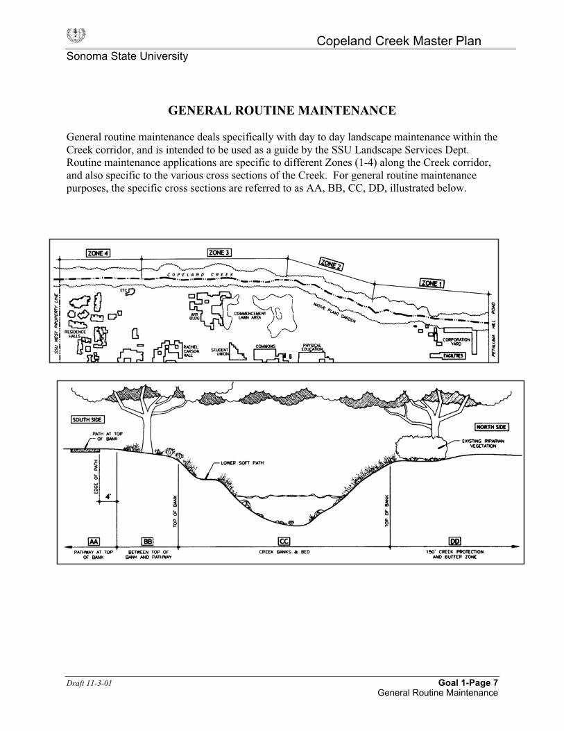
GENERAL ROUTINE MAINTENANCE
General routine maintenance deals specifically with day to day landscape maintenance within theCreek corridor, and is intended to be used as a guide by the SSU Landscape Services Dept.Routine maintenance applications are specific to different Zones (1-4) along the Creek corridor,and also specific to the various cross sections of the Creek. For general routine maintenancepurposes, the specific cross sections are referred to as AA, BB, CC, DD, illustrated below.

Copeland Creek Master PlanSonoma State University
Draft 11-3-01 Goal 1-Page 8General Routine Maintenance
WEEDING
General Routine MaintenanceCreek Cross Sectional AreaPer Illustration on page 7
AA Pathways at Top of Bank:
Weed control to keep the path, whether a bike path or a service road, cleared is permittedwithin four feet of the path by power mower, a weed-eater or by manual techniques.
BB Between Top of Bank, and Pathways at Top of Bank (south side only):
Weeding in the riparian corridor between the bike path and/or the service road and thecreek bank beyond the first four feet shall vary according to zones as identified:
Zones shown on page 7
Zone 1: No weed control will be permitted except by direction of the Director of Facilitiesand the Creek Committee.
Zone 2: Weed control using a weed-eater or hand methods will be permitted. Nativespecies should not be cut. Native species should not be cut.
Zone 3: Hand weeding only in conjunction with restoration program will be permitted.Zone 4: Weed control using a weed-eater or hand methods will be permitted up to the
dripline of the willow trees until such time as restoration programs begin in thatzone. Native species should not be cut.
CC Creek Banks and Bed:
No weed control will be permitted in the inner creek bed unless associated with vegetationrestoration activities, which is outlined under Goal 2 of the Copeland Creek Master Plan.
DD North side Creek Protection Zone and BufferWeed control within the canopy of the existing willows will be by manual techniques.Weed control outside of the existing riparian vegetation is permitted by hand or by weed-eater with the goal that targets nonnative plants only. Native planting should be identifiedand encouraged. This will encourage expansion of the riparian forest and upland habitat.
TREE TRIMMING
AA Pathways at Top of Bank:Tree trimming to keep the path, whether a bike path or a service road, cleared is permittedwithin four feet of the path.Tree and brush trimming is allowed where trees and brush interfere with restorationplanting.

Copeland Creek Master PlanSonoma State University
Draft 11-3-01 Goal 1-Page 9General Routine Maintenance
BB Between Top of Bank, and Pathways at Top of Bank:
Trees that are blocking interior paths and/or causing safety hazards or damage to othervaluable plant species, shall be trimmed to remove the offending limbs only. Wherepossible, cut limbs shall be placed on the surrounding ground.Tree and brush trimming is allowed where trees and brush interfere with restorationplanting.
CC Creek Bed and Banks:
Only trees that have become debris collectors because they are situated in such a way as tohave limbs positioned against the stream flow, shall be trimmed to remove the offendinglimbs. Also reference Goal 5-Page 8 for additional detail and clarification of tree and limbremoval.
SPRAYING
• There will be no spraying of biocides in the areas designated as AA, BB, CC, DD, asoutlined on the graphic above, unless approved by the Director of Facilities Planning andCreek Committee.
DEBRIS AND GARBAGE
Organic debris:No composting or dumping of grass clippings, bark or other organic materials will beallowed, except on approved pathways, or as part of an approved restoration project applieddirectly around plants for mulch material.
Inorganic debris:Trash will be removed either by Facilities Services maintenance crews or by participants onapproved creek work days.
Trash collection:Trash containers along the Creek corridor will be emptied as needed, but at least on aweekly basis by Facilities Services. If, in the interest of creek protection, it appears thattrash collection needs to occur more often, Facilities Services and the Director of FacilitiesPlanning will monitor and establish a more suitable schedule. Campus entities that arefrequent sources of trash in the creek zone will be contacted and informed of the policyagainst dumping and the importance of protecting the creek zone.

Copeland Creek Master PlanSonoma State University
Draft 11-3-01 Goal 1-Page 10General Routine Maintenance
SOFT PATH MAINTENANCE
Lower elevation soft paths will be cleared by volunteer work crews and Facilities Servicesunder supervision on approved creek work days. These paths will be maintained by lowimpact manual methods to protect surrounding plants.
STORM DRAIN ROUTINE MAINTENANCE
Reference Policy 5B #2, (Goal5-Page 7), for approved methods. Any deviation from thesemethods is illegal, and not approved by the University.
IMPLEMENTATION PROCEDURES
1. Information/training sessions will be conducted with Facilities Services maintenancecrew at the initial adoption of these maintenance policies and procedures and thereafter,at least on a yearly basis as outlined in Goal 1-Page 1, Policy 1A.d.
2. Facilities Services shall record work done in the Creek corridor and provide this recordto the Director of Facilities Planning and Creek Committee, at a minimum, on aquarterly basis
3. Facilities Services has the responsibility for weed control as described in Section 1above.
4. Facilities Services has the responsibility for tree trimming activities as described inSection 2 above.
5. Facilities Services has the responsibility for storm drain routine maintenance asdescribed in Section 6 above.
6. Facilities Services shall work with the Director of Facilities Planning to update this‘General Routine Maintenance’ document on a yearly basis, and maintain a currentcopy in the Facilities Services area.
7. Facilities Services will coordinate with volunteer work crews for the soft pathmaintenance.

Copeland Creek Master PlanSonoma State University
Draft 11-7-01 Goal 2-Page 1
GOAL 2:
Restore native species, biotic communities, ecological processes, andconditions in Copeland Creek and its associated in-stream, riparian,
transitional, and upland habitats.
The ecological integrity of stream corridor ecosystems is directly related to the integrityand ecological characteristics of the plant communities that make up and surround thecorridor. These plant communities are a valuable source of energy and nutrients for thebiological communities, provide physical habitat, and moderate fluxes of energy andmaterials to and from the surrounding aquatic and terrestrial ecosystems.1
Improving and restoring the riparian plant communities provides a means of enhancinghabitat for indigenous cold water fish, amphibians, birds, aquatic organisms and smallmammals. Other benefits of healthy riparian plant communities relative to ecologicalprocesses include2:� Provide temporary floodwater storage and gradually convey floodwater to stream
and water table.� Reduce the level of downstream flooding through storage and friction with
vegetation upstream.� Anchor soil on creek bank reducing erosion and sedimentation� Filter and store sediment from erosion in the watershed.� Filter and trap excess nutrients and pollutants from the stream and from overland
runoff, fertilizers, eroded soils.� Slow the velocity of storm runoff, thus reducing erosion of the stream channel.� Create aesthetically pleasing settings for bringing people closer to nature, and an
appreciation for nature.
This section outlines policies directly related to vegetation and wildlife conditions as apart of the overall restoration and health of Copeland Creek.
POLICY 2A: CONSERVE AND ENHANCE NATIVE VEGETATION ANDWILDLIFE HABITAT.
Implementation Measure:
2A.a. Inventory vegetation and wildlife species.An understanding of existing plant and animal species in the creekcorridor will serve as a basis for determining what is needed forrestoration. The Creek Committee will work with University Departments
1 Adapted from Stream Corridor Restoration. Principles, Processes, and Practices. The FederalInteragency Stream Restoration Working Group. October 1998.2 Adapted from Greenways, The Conservation Fund, 1993, Island Press

Copeland Creek Master PlanSonoma State University
Draft 11-7-01 Goal 2-Page 2
to inventory and maintain species lists. An inventory shall be updated atregular intervals, and incorporated and filed with this Master Plan.Mapping of significant vegetation in diagrammatic form shall accompanythe inventory for reference. The intent is not to identify the location ofevery plant, but to identify significant stands of vegetation, or vegetationof concern.
The following documents are intended to be used as initial resources only,in anticipation of future inventory projects. Reference attachments at theend of this Goal 2 section:
1. Native Plant Garden Area Vegetation Inventory2. Bird Sightings by Rebecca Olsen3. Wildlife and Sensitive Species Surveys for Music Center by
Michael Fawcett4. Special Status Species from SSU Master Plan EIR by ESA5. List of Species Suitable to Copeland Creek Corridor6. List of Exotic Species Known to the Copeland Creek Corridor
that Should be Removed7. List of Native and Naturalized Plants Originally Found Growing
Along Copeland Creek at SSU
Implementation Measure:
2A.b. Identify a central location for maintaining records and documents.The Director of Facilities Planning will maintain a copy of the CreekMaster Plan as well as master files for vegetation and wildlife inventories,and restoration projects.
Implementation Measure:
2A.c. Obtain aerial photographs of the Creek Corridor.The Creek Committee and the Director of Facilities Planning shallmaintain contact with the County of Sonoma in order to obtain access tocurrent aerial photographs of the Creek Corridor. These photographs are auseful tool for monitoring riparian canopy growth.
Implementation Measure:
2A.d. Identify and remove exotic species, and replace with native species.The introduction and presence of exotic species, whether intentional ornot, can cause disruptions to native ecosystems. Non-native speciescompete with native species for moisture, nutrients, sunlight, and space,and can adversely influence establishment rates for new plantings, andhabitat. Exotic plant species can detract from the recreational value ofstreams by creating an impenetrable thicket along the creek. As part of theinventory and mapping outlined above, exotic species shall also beidentified. Removal of exotic species and replacement by native specieswhere appropriate shall be permitted through the Director of Facilities

Copeland Creek Master PlanSonoma State University
Draft 11-7-01 Goal 2-Page 3
Planning and Copeland Creek Committee, and by application as outlinedunder Goal 1-Policy 1-B. The methods for removal shall be outlined inthe application.
The Creek Committee shall determine and update priorities for exoticremoval.
Implementation Measure:
2A.e. Develop acceptable guidelines and plant species/communities forrestoration according to planting zones.
General guidelines for planting zones are outlined on Figure 2A.e. Plantsshould be chosen based on their adaptability and tolerance to soil moisturelevels. Refer to the ‘List of Species Suitable to the Copeland CreekCorridor’ in the appendix of this Goal 2 section. This plant list is intendedas an initial list only, and may be modified through research and reportingto the Creek Committee.
Planting projects shall be approved by the Director of Facilities Planningand the Copeland Creek Committee, and by application as outlined underGoal 1. The planting proposal shall include planting techniques,provisions for plant protection as needed (stakes, cages, plant tubes, etc.),irrigation schedule, maintenance and monitoring responsibilities, speciesand quantities proposed and diagrammatic mapping. Base mapping forlocating restoration projects is available from the Director of FacilitiesPlanning.
Implementation Measure:
2A.f. Monitor plant survival and development, habitat enhancement, andstatus of species.
Prepare monitoring reports as outlined by the conditions of each project’sapproval, for submittal to the Creek Committee and the Director ofFacilities Planning. The goal is to undertake remedial planting as neededto bring shortcomings into compliance with the revegetation successcriteria. See Section 4B.
Implementation Measure:
2A.g. Include restoration and research as part of the SSU curriculum.The Creek Committee and the Director of Facilities Planning shallevaluate proposals for restoration and research efforts based upon Goalsestablished by this Master Plan. Reference Goal 4 policies outliningEducational Outreach and Research Opportunities, for direction.
Implementation Measure:
2A.h. Identify plant and animal special status species*.The Creek Committee shall identify special status species with thepotential to occur in the creek corridor, and those that would benefit from

Copeland Creek Master PlanSonoma State University
Draft 11-7-01 Goal 2-Page 4
protection through habitat enhancement. This list should be updated on ayearly basis in conjunction with listings generated by the National MarineFisheries Service, State Dept. of Fish and Game, and U.S. Fish andWildlife Service, and be made a part of this Master Plan. Local Fish andGame should confirm this list. Initial information regarding plants andanimals is outlined by the attached documents at the end of this section,Goal 2:
1. Wildlife and Sensitive Species Surveys for Music Center byMichael Fawcett
2. Special Status Species from SSU Master Plan by ESA

Copeland Creek Master PlanSonoma State University
Draft 11-3-01 Appendix to Goal 2Preferred Plant List
Copeland Creek Corridor
LIST OF SPECIES SUITABLE TOCOPELAND CREEK CORRIDOR
October 2001
Copeland Creek RestorationPlant selection: Riparian Area on the south side of the creek
In areas that are hot, dry and sunny:Concerns: Open understory is advantageous, for reasons of both safety
and aesthetics
Trees: Valley Oak Quercus lobata
California Buckeye Aesculus californicaCoast Live Oak Quercus agrifolia
Madrone Arbutus menziesiiCalifornia Bay Umbellularia californicaBlack Oak Quercus kelloggiiCalifornia Walnut Juglans californica var. hindsii
Understory:Blue Elderberry Sambucus mexicanaManzanita Arctostaphylos manzanitaCalifornia Lilac Ceonothus thyrsiflorusCoyote brush Baccharis pilularisCoffeeberry Rhamnus californicaBunchgrass Nassella pulcraBunchgrass Festuca californica
In high middle areas; marginally cooler, shadier and moister than Edge:Unshaded areas:
all the species proposed for the edge zone(when more shade is available, the species composition can change)
Shaded areas Trees:Valley Oak Quercus lobataOregon Ash Fraxinus latifoliaCal. Walnut Juglans californica var. hindsiiBigleaf Maple Acer macrophylumCalifornia Bay Umbellularia californicaCalifornia Buckeye Aesculus californica

Copeland Creek Master PlanSonoma State University
Draft 11-3-01 Appendix to Goal 2Preferred Plant List
Copeland Creek Corridor
Understory:California Blackberry Rubus ursinusCalifornia native grape Vitis californicaBlue elderberry Sambucus mexicanaCalifornia Hazelnut Corulus cornutaCalifornia Wild Rose Rosa gymnocarpaNinebark Physocarpa capitatusCreambush Holodiscus discolorCoffeeberry Rhamnus californicaHoneysuckle Lonicera hispidulaMugwort Artemesia douglasiana
In areas that are low/shaded middle areas, shady and moister:Trees
WillowsArroyo Salix lasiolepisRed Saliz laevigata
Fremont cottonwood Populus fremontiiWhite Alder Alnus rhombifoliaBigleaf Maple Acer macrophylumCalif. Walnut Juglans californica var. hindsiiBox Elder Acer negundo var. californicum
Understory:California Blackberry Rubus ursinusWestern Spicebush Calycanthus occidentalisCalifornia Hazelnut Corylus cornutaCalifornia Wild Rose Rosa gymnocarpaTwinberry Lonicera involucrataNinebark Physocarpus capitatusWestern Azalea Rhododendron occidentalisRed stem Dogwood Cornus sericea ssp. sericeaBlue Elderberry Sambucus mexicanaSnowberry Symphoricarpus albusPink flowering currant Ribes sanguinum var.
glutinosumDutchman's Pipe Aristolochia californicaHoneysuckle Lonicera hispidulaMugwort Artemesia douglasiana
Copeland Creek Master PlanSonoma State University
Draft 11-3-01 Appendix to Goal 2Preferred Plant List
Copeland Creek Corridor
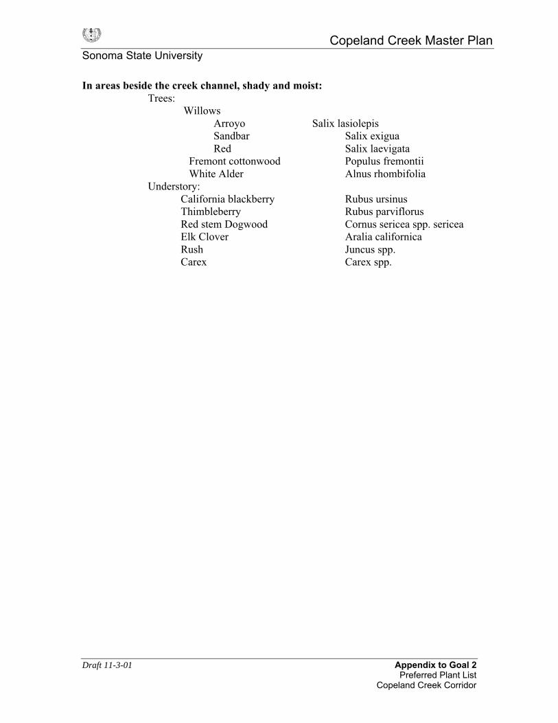
In areas beside the creek channel, shady and moist:Trees:
WillowsArroyo Salix lasiolepisSandbar Salix exiguaRed Salix laevigata
Fremont cottonwood Populus fremontii White Alder Alnus rhombifoliaUnderstory:
California blackberry Rubus ursinusThimbleberry Rubus parviflorusRed stem Dogwood Cornus sericea spp. sericeaElk Clover Aralia californicaRush Juncus spp.Carex Carex spp.

Copeland Creek Master PlanSonoma State University
Draft 11-3-01 Appendix to Goal 2Exotic Species List
Copeland Creek Corridor
LIST OF EXOTIC SPECIES KNOWN TO THECOPELAND CREEK CORRIDOR THAT SHOULD BE REMOVED
OVER TIME
October 2001
Periwinkle Vinca majorMaytens tree Maytenus boariaTree of Heaven Ailantus altissimaHimalayan Blackberry Rubus discolorBlack Locust Robinia pseudoacaciaWild Plum Prunus spEucalyptus Eucalyptus sp.Poison Hemlock Conium maculatumFennel Foeniculum vulgare
.
Copeland Creek Master PlanSonoma State University
Draft 11-3-01 Appendix to Goal 2Exotic Species List
Copeland Creek Corridor
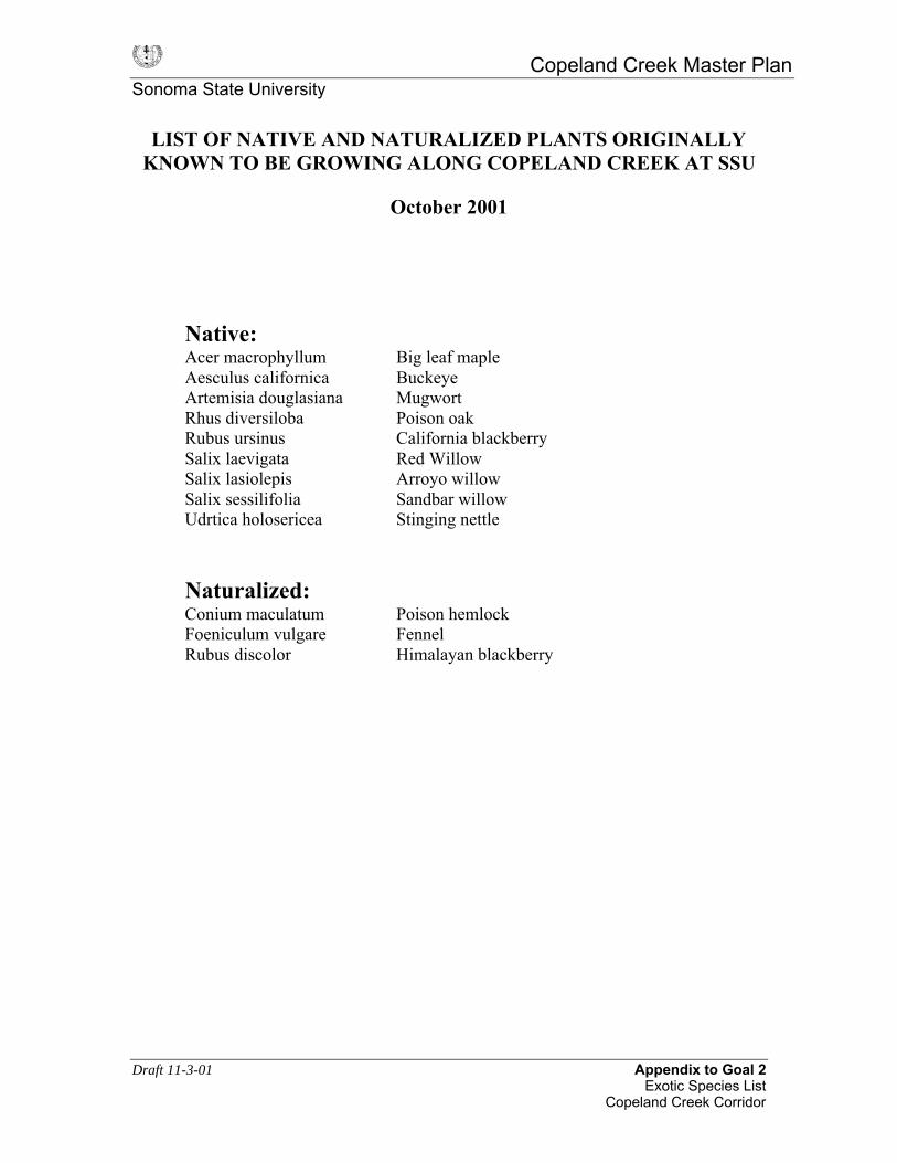
LIST OF NATIVE AND NATURALIZED PLANTS ORIGINALLYKNOWN TO BE GROWING ALONG COPELAND CREEK AT SSU
October 2001
Native:Acer macrophyllum Big leaf mapleAesculus californica BuckeyeArtemisia douglasiana MugwortRhus diversiloba Poison oakRubus ursinus California blackberrySalix laevigata Red WillowSalix lasiolepis Arroyo willowSalix sessilifolia Sandbar willowUdrtica holosericea Stinging nettle
Naturalized:Conium maculatum Poison hemlockFoeniculum vulgare FennelRubus discolor Himalayan blackberry

Copeland Creek Master PlanSonoma State University
Draft 11-3-01 Appendix to Goal 2Vegetation Inventory
Native Plant Garden Area
NATIVE PLANT GARDEN AREA VEGETATION INVENTORY
Compiled by Karen Tillinghast 2000
Acer macrophyllum Big Leaf Maple TreeAcer negundo ssp. californicum Box Elder TreeAdiantum jordani California Maidenhair Fern PerennialAesculus califorrnica California Buckeye TreeAlnus oregana Red Alder TreeAlnus rhombifolia White Alder TreeAmelanchier pallida Serviceberry ShrubAquilegia formosa Columbine PerennialAralia californica Elk Clover PerennialArbutus menziesii Madrone TreeArtemisia douglasiana California Mugwort PerennialBerberis aquifolium Oregon Grape ShrubBlechnum spicant Deer Fern PerennialCalycanthus occidentalis Spice Bush ShrubCeanothus thyrsiflorus California Lilac ShrubChamaecyparis lawsoniana Lawson Cypress TreeCornus nuttallii Mountain Dogwood TreeCornus occidentalis Creek Dogwood ShrubCoryulus cornuta Western Hazelnut TreeDatura stramonium Jimson Weed PerennialDicentra formosa Bleeding Heart PerennialDryopteris arguta Wood Fern PerennialFragaria californica California strawberry PerennialFraxinus latifolia Oregon Ash TreeHeracleum lanatum Cow Parsnip PerennialHeuchera micrantha Alum Root PerennialHolodiscus discolor Cream Bush/Ocean Spray ShrubIris douglasiana Douglas Iris PerennialJuglans hindsii California Walnut TreeLithocarpus densiflora Tan Bark Oak TreeMaianthemum dilatatum False Lily of the Valley PerennialMyrica californica Wax Myrtle ShrubNicotiana bigelovii Indian Tobacco AnnualOxalis oregana Redwood Sorrel PerennialPetasites palmatus Western Coltsfoot PerennialPhysocarpus capitatus Nine Bark ShrubPicea sitchensis Sitka Spruce TreePinus jeffreyi Jeffrey Pine TreePinus murrayana Lodgepole Pine Tree

Copeland Creek Master PlanSonoma State University
Draft 11-3-01 Appendix to Goal 2Vegetation Inventory
Native Plant Garden Area
Platanus racemosa Sycamore TreePolypodium californicum California Polypody Fern PerennialPolystichum munitum Sword Fern PerennialPopulus fremontii Fremont Cottonwood TreePseudotsuga menziesii Douglas-fir TreePteridium aquilinum Braken Fern PerennialQuercus agrifolia Coast Live Oak TreeQuercus kelloggii Black Oak TreeQuercus lobata Valley Oak TreeRhamnus purshiana Cascara Sagrada TreeRhododendron occidentale Western Azalea ShrubRhus diversiloba Poison Oak VineRhus trilobata Squaw Bush ShrubRibes aureum Golden Currant ShrubRibes menziesii Gooseberry ShrubRibes sanguineum var.glutinosum Pink Flowering Currant ShrubRosa gynmocarpa Wood Rose ShrubRubus parviflorus Thimbleberry ShrubRubus ursinus California Blackberry VineSalix Hindsiana Sandbar Willow TreeSalix laevigata Red Willow TreeSalix lasiandra Yellow Willow TreeSalix lasiolepis Arroyo Willow TreeSambucus mexicana Blue Elderberry ShrubSambucus callicarpa Red Elderberry ShrubSatureja douglasii Yerba Buena PerennialScrophularia californica Beeplant PerennialSequoia sempervirons Coast Redwood TreeStachys rigida Hedge Nettle PerennialSymphoricarpos albus Snowberry PerennialTellima grandiflora Fringecups PerennialThuja plicata Western Red Cedar TreeTiarella unifoliata Sugar Scoop PerennialTsuga heterophylla Western Hemlock TreeUmbellularia californica California Bay TreeUrtica holosericea Stinging Nettle PerennialVaccinium ovatum California Huckleberry ShrubViola adunca Violet PerennialViola sempervirons Evergreen Violet PerennialWhipplea modesta Yerba de Selva PerennialWoodwardia fimbriata Giant Chain Fern Perennial

Draft 11-3-01 Appendix to Goal 2Michael Fawcett Report
AQUATIC AND TERRESTRIAL WILDLIFE RESOURCES ANDSENSITIVE SPECIES SURVEYS, SONOMA STATE UNIVERSITY
MUSIC CENTER DEVELOPMENT AREA
Prepared for Sonoma State University1801 East Cotati AvenueRohnert Park, CA 94928
By Michael H. Fawcett, Ph.D., Ecologist
June 1, 2000
INTRODUCTION
This report covers wildlife resources and habitat of lands, wetlands, and streams that maybe affected by development of Sonoma State University’s new music center withassociated parking facilities and new crossings of Copeland Creek. The work reportedhere is focussed on sensitive (i.e., special status) species, and is intended to supplementinformation provided in the EIR for the project. The project site consists of property(Anderson, Henderson, and Keyhole parcels) bordering the north side of Copeland Creekadjacent to the main campus. Most of the acreage proposed for development consists ofpreviously cleared and farmed grasslands containing some bits of jurisdictional wetlands.The Keyhole parcel includes a remnant of riparian woodland plus a seasonal pond andmarsh called Keyhole Marsh. Copeland Creek, which borders all three parcels, drains thearea north and west of Sonoma Mountain. It has a dense riparian corridor along its northside in the campus area, and is tributary to the Laguna de Santa Rosa and the RussianRiver.
APPROACH
I conducted a series of seven site visits and field surveys from December 1999 throughMay 2000 in an attempt to establish the presence or absence of several sensitive aquaticspecies in the seasonal pond areas, riparian areas, and the reach of Copeland Creek thatincludes the proposed stream crossings. A heavy aquatic dipnet was used to searchseasonal wetlands for larval amphibians. The main species in question are listed in thefollowing table:
Species Common Name Listing Status in ProjectArea*
Oncorhynchus kisutch Coho salmon FTOncorhynchus mykiss Steelhead FTAmbystoma californiense California tiger salamander CSSC, FSCRana boylii Foothill yellow-legged frog CSSCRana aurora aurora Northern red-legged frog CSSC**Rana aurora draytonii California red-legged frog FT**Clemmys marmorata Western pond turtle CSSC

Draft 11-3-01 Appendix to Goal 2Michael Fawcett Report
* FT = federally Threatened SpeciesFSC = federal Species of Concern
CSSC = California Species of Special Concern
** Red-legged frogs in the Russian River watershed are presently designated by theU.S. Fish and Wildlife Service as the northern subspecies (Rana aurora aurora) and arethus exempt from the federal listing for California red-legged frogs. However, recentgenetic studies have shown that all of the red-legged frogs in Sonoma County and incoastal areas as far north as Point Arena, Mendocino County, are, in fact, genetically notdifferent from California red-legged frogs. USFWS has not yet proposed any changes tothe current geographic boundary for the listed populations.
EXISTING HABITAT AND WILDLIFE RESOURCESCopeland Creek
Copeland Creek in the campus area is considered to be a migration corridor for steelhead,which apparently still spawn in the upper watershed east of Petaluma Hill Road (BillCox, pers. comm.). Copeland Creek and the adjacent riparian zone are designated criticalhabitat for coho salmon, and proposed critical habitat for steelhead. Both coho andsteelhead probably spawned and reared young historically in Copeland Creek, includingthe reach that runs through the SSU campus. However, the stream has been heavilyimpacted by past land use practices, as have most streams in this region. Now, during atypical summer, all of the reach along the campus goes dry, and therefore does notsupport salmonid spawning or rearing, nor any resident fish populations. Although Iobserved gravel beds along the SSU reach that appeared to be potentially suitable forsteelhead spawning, I found no evidence of spawning activity (i.e., no redds nor adultfish) during several surveys conducted during prime spawning periods following rains inJanuary through April. In fact, I saw no fish of any species during the surveys.
Since both steelhead and coho juveniles need at least one summer of rearing in freshwaterstreams (usually not far from where they emerged from the gravel beds in the spring)before going to sea to mature, it is not surprising that no spawning occurs near thecampus now. If no juveniles have survived the summer in the campus reach for severalyears, there would be no predictable run of adults seeking the campus area to spawn.Those that still spawn higher up in the watershed may be imprinted to the upperwatershed, i.e., the returning adults will follow chemosensory cues upstream past thecampus and keep going until they reach the area where they were reared.
The only vertebrates I found in Copeland Creek in the project area were Pacific treefrogs, Hyla regilla (adults, eggs, and larvae), and foothill yellow-legged frogs (two adultsfound on final visit on May 5th. Foothill yellow-legged frogs are fully protected as stateSpecies of Special Concern, but are still fairly common in rocky streams in SonomaCounty. No western pond turtles nor red-legged frogs were seen.

Draft 11-3-01 Appendix to Goal 2Michael Fawcett Report
The riparian zone along Copeland Creek (and also the remnant patch that protrudes intothe Keyhole Marsh) provides important habitat for a variety of birds, mammals, reptiles,and amphibians. Although the surveys were focussed on sensitive aquatic species of fish,reptiles, and amphibians, I made notes of other animals observed during the surveys.Raptors frequently observed in the riparian areas included red-tailed hawks, red-shouldered hawks, and a pair of black-shouldered kites. No raptor nests were seen.Other birds commonly sighted include scrub jay, northern flicker, American robin, housesparrow, song sparrow, and California towhee. (Many of these birds, including theraptors, were also seen foraging or hunting in upland and wetland areas). I also observedon different occasions one great blue heron roosting in a tree, and a dead northern pygmyowl. Tracks of mule deer, raccoon, opossum, striped skunk, and fox were observed alongthe creek or in the riparian areas. Two species of terrestrial salamander were seen in theriparian areas: yellow-eyed Ensatina (Ensatina eschscholtzii xanthopicta) and Californiaslender salamander (Batrachoceps attenuatus). Western terrestrial garter snakes(Thamnophis elegans) were seen in riparian and upland areas.
Seasonal Ponds, Wetlands, and Uplands
Keyhole Marsh includes a seasonal pond (or vernal pool, depending on how one isdefined) that holds water up to a foot deep for several months of each year during the wetseason. In the 1999-2000 wet season, ponding did not occur until late January or earlyFebruary; the pond had no standing water on January 24th, but was filled when I returnedon February 9th. It remained full throughout February, March, and April, and was stillfull on my final visit on May 5th. Other, smaller seasonal ponds scattered within theproject area (documented by Marco Waaland), as well as the old ditch crossing theHenderson parcel diagonally, held water for varying periods during the wet season, butwere all dry by May 5th.
The presence of the seasonal ponds in the project area, coupled with the abundance ofsmall mammal burrows in adjacent uplands or riparian areas (especially Botta’s pocketgopher, California vole, and broad-handed mole), suggested the possible occurrence ofCalifornia tiger salamanders. Adults of this species spend their lives underground inmammal burrows, except for a brief interval when they breed in vernal pools, seasonalponds, or similar areas. The larvae spend several months in the ponds beforetransforming to the adult stage in late spring or early summer, whereupon they leave theponds during darkness and seek out nearby burrows to begin their underground life.Vernal pools or ponds in the Laguna de Santa Rosa area that are currently known tosupport breeding populations of tiger salmanders typically are a foot or more deep, havesome open water (i.e., they’re not completely clogged with emergent or submergentvegetation), and have dense populations of Pacific treefrog tadpoles and clam shrimp(fingernail-size crustaceans related to fairy shrimp). The pond in Keyhole Marsh appearsto be potentially suitable, in terms of timing, duration, and abundance of treefrog larvae,but is filled with dense vegetation and lacks clam shrimp. In any case, no salamanderlarvae were found in several searches by intensive dipnetting, nor were any found inother ponds in the project area.

Draft 11-3-01 Appendix to Goal 2Michael Fawcett Report
PROJECT CONSTRAINTS AND RECOMMENDATIONS
As I understand the project development plan, existing riparian areas and the entireKeyhole Marsh area will be preserved. I support that plan, as these areas and CopelandCreek itself represent to me the types of wildlife habitat most in need of protection in theRohnert Park region. A functional riparian corridor is essential to maintaining theexisting (although diminished) value of Copeland Creek as a fishery and wildliferesource. A corridor of riparian trees provides essential resources to the stream, e.g.,nutrients (leaves, twigs, terrestrial insects) and woody debris, and serves essentialfunctions, such as cooling the water and reducing evaporation, stabilizing stream banksand reducing erosion, and slowing the rate of groundwater discharge into the stream,which (in combination with the cooling effect of shade) allows surface stream flow inmany small streams to persist through the summer. One of the common effects ofrestoring a functional riparian corridor to a denuded, seasonal stream is that perennialflow may return.
In the case of Copeland Creek, if a riparian corridor were restored to the denuded streambanks on the agricultural lands east of Petaluma Hill Road, I would expect to eventuallysee at least intermittent summer flow return to the campus reach, as its riparian corridor isin relatively good condition. Intermittent surface flow or subsurface flow sufficient tomaintain some cool, shaded pools throughout the summer may be a sufficientimprovement to eventually encourage steelhead to begin spawning and rearing in thecampus reach again. Undoubtedly, a few trees will have to be taken out in order toconstruct the stream crossings and access roads or paths to the new music center. Thiscan be mitigated by planting more trees, or in other ways, but will require site-specificapproval by both the National Marine Fisheries Service and the Department of Fish andGame, as will the bridge design and construction.
Since the project area apparently does not currently support California tiger salamanders,loss of mammal burrows in upland areas to be developed should not be a major issue, norshould loss of some of the jurisdictional wetlands, which can be mitigated (as perplanning already underway by Marco Waaland, Quadriga, and SSU).

Draft 11-3-01 Appendix to Goal 2Draft 9-14-01 Special Status Species
SSU Master PlanBy ESA
Taken from SSU Master Plan Revision EIRResponse to Comments
Environmental Science Associates, 2000

Draft 11-3-01 Appendix to Goal 2Draft 9-14-01 Special Status Species
SSU Master PlanBy ESA
Taken from SSU Master Plan Revision EIRResponse to Comments
Environmental Science Associates, 2000

Draft 11-3-01 Appendix to Goal 2Draft 9-14-01 Special Status Species
SSU Master PlanBy ESA
Taken from SSU Master Plan Revision EIRResponse to Comments
Environmental Science Associates, 2000

Draft 11-3-01 Appendix to Goal 2Draft 9-14-01 Special Status Species
SSU Master PlanBy ESA
Taken from SSU Master Plan Revision EIRResponse to Comments
Environmental Science Associates, 2000

Draft 11-3-01 Appendix to Goal 2Draft 9-14-01 Special Status Species
SSU Master PlanBy ESA
Taken from SSU Master Plan Revision EIRResponse to Comments
Environmental Science Associates, 2000

Draft 11-3-01 Appendix to Goal 2Draft 9-14-01 Special Status Species
SSU Master PlanBy ESA

Copeland Creek Master PlanSonoma State University
Draft 11-3-01 Appendix to Goal 2Rebecca Olsen Bird List
SONOMA STATE BIRD LISTCOPELAND CREEK / NATIVE PLANT GARDEN AREA
Sightings by Rebecca Olsen1999
SEPTEMBER
Bushtit, Common 9/13/99Chickadee, Chestnut-sided 9/24/99Duck, Mallard 9/10/99Flycatcher, Pacific-slope 9/10/99Goose, Canada 9/29/99Hawk, Red-shoulder 9/24/99Hummingbird, Anna’s 9/24/99Jay, Scrub 9/24/99Kingfisher, Belted 9/22/99Oriole, Bullocks 9/15/99Phoebe, Black 9/13/99Quail, California 9/29/99Raven, Common 9/24/99Robin, American 9/10/99Sparrow, Song 9/10/99Towhee, California 9/10/99Vulture, Turkey 9/24/99Warbler, MacGillvray’s 9/10/99Warbler, Wilson’s 9/10/99Woodpecker, Downy 9/10/99Woodpecker, Nuttal’s 9/10/99Wren, Bewick’s 9/10/99
OCTOBER
Blackbird, Brewer’s 10/18/99Bushtit 10/25/99Chickadee, Chestnut-backed 10/4/99Coot 10/25/99Creeper, Brown 10/6/99Crow American 10/18/99Duck, Mallard 10/6/99Flicker, Northern 10/25/99Flycatcher, Pacific-slope 10/4/99Hawk, Broad-wing 10/20/99Hawk, Red-shoulder 10/4/99Hawk, Red-tail 10/4/99Hummingbird, Anna’s 10/4/99Jay, Scrub 10/6/99Kestrel, American 10/25/99Kinglet, Ruby-crown 10/18/99Phoebe, Black 10/6/99Quail, California 10/20/99Raven, Common 10/6/99Robin, American 10/4/99Sparrow, Golden-crown 10/18/99Sparrow, Song 10/18/99Thrush, Hermit 10/20/99Towhee, California 10/4/99Towhee, Spotted 10/6/99Vulture, Turkey 10/6/99Warbler, Orange-crowned 10/22/99Warbler, Yellow-rumped 10/18/99Woodpecker, Downy 10/20/99Woodpecker, Nuttal’s 10/4/99Wren, Winter 10/18/99

Copeland Creek Master PlanSonoma State University
Draft 11-3-01 Appendix to Goal 2Rebecca Olsen Bird List
SONOMA STATE BIRD LISTCOPELAND CREEK / NATIVE PLANT GARDEN AREA
Sightings by Rebecca Olsen1999
NOVEMBER
Blackbird, Brewer’s 11/3/99Bushtit 11/3/99Chickadee, Chestnut-backed 11/17/99Coot 11/17/99Duck, Mallard 11/3/99Falcon, Peregrine 11/17/99Flicker, Northern 11/3/99Hawk, Red-shoulder 11/3/99Hawk, Red-tail 11/3/99Jay, Scrub 11/3/99Kinglet, Ruby-crowned 11/3/99Pelican, White 11/3/99 (Flying Over)Phoebe, Black 11/3/99Raven, Common 11/22/99Robin, American 11/17/99Sparrow, Song 11/17/99Thrush, Hermit 11/3/99Towhee, California 11/3/99Towhee, Spotted 11/17/99Vireo Hutton’s 11/22/99Vulture, Turkey 11/3/99Warbler, Townsend’s 11/17/99Warbler, Yellow-rumped 11/3/99Waxwings, Cedar 11/3/99Woodpecker, Nuttal’s 11/3/99Wren, Winter 11/3/99
DECEMBER
Bushtit 12/13/99Chickadee, Chestnut-backed 12/6/99Coot 12/6/99Crow, American 12/13/99Duck, Mallard 12/6/99Flicker, Northern 12/6/99Goldfinch, American 12/6/99Goldfinch, Lesser 12/6/99Hawk, Red-tail 12/13/99Hawk-Sharp-shinned 12/6/99Hummingbird, Anna’s 12/13/99Jay, Scrub 12/6/99Kestrel, American 12/6/99Kinglet, Ruby-crowned 12/6/99Owl, Great-horned 12/7/99Phoebe, Black 12/13/99Raven, Common 12/13/99Robin, American 12/6/99Towhee, California 12/6/99Vulture, Turkey 12/6/99Warbler, Townsend’s 12/6/99Waxwing, Cedar 12/13/99Woodpecker, Nuttal’s 12/13/99Killdeer 12/17/99

Copeland Creek Master PlanSonoma State University
Draft 11-3-01 Appendix to Goal 2Rebecca Olsen Bird List
SONOMA STATE BIRD LISTCOPELAND CREEK / NATIVE PLANT GARDEN AREA
Sightings by Rebecca Olsen2000
JANUARY
Chickadee, Chestnut-backed 1/28/00Coot 1/28/00Crow, American 1/28/00Duck, Golden-eye 1/28/00Duck, Mallard 1/28/00Finch, House 1/28/00Hummingbird, Anna’s 1/28/00Jay, Scrub 1/28/00Kinglet, Ruby-crowned 1/28/00Kite, White-tailed 1/28/00Merganzer, Common 1/28/00Phoebe, Black 1/28/00Robin, American 1/28/00Sparrow, Song 1/28/00Towhee, California 1/28/00Vulture, Turkey 1/28/00Warbler, Yellow-rumped 1/28/00
FEBRUARY
Mockingbird, Northern 2/1/00Towhee, California 2/1/00Raven, Common 2/1/00Kinglet, Ruby-crowned 2/1/00Gull (species) 2/1/00Hummingbird, Anna’s 2/1/00
MARCH
Bushtits, Common 3/22/00Chickadee, Chestnut-backed 3/22/00Crow, American 3/24/00Dove, Mourning 3/20/00Duck, Mallard 3/24/00Finch, House 3/22/00Flicker, Northern 3/24/00Goldfinch, American 3/22/00Goldfinch, Lesser 3/22/00Hawk, Red-shouldered 3/20/00Hawk, Red-tailed 3/22/00Hummingbird, Allen’s 3/24/00Hummingbird, Anna’s 3/22/00Jay, Scrub 3/22/00Juncos, Dark-eyed 3/22/00Kinglet, Ruby-crowned 3/22/00Merganzer, Common 3/20/00Phoebe, Black 3/22/00Raven, Common 3/22/00Robin, American 3/24/00Sparrow, Lincoln’s 3/22/00Sparrow, Song 3/22/00Swallow, Tree 3/24/00Thrush, Hermit 3/22/00Towhee, California 3/22/00Vulture, Turkey 3/22/00Warbler, Yellow-rumped 3/22/00Woodpecker, Downy 3/22/00Woodpecker, Nuttals 3/22/00

Copeland Creek Master PlanSonoma State University
Draft 11-3-01 Appendix to Goal 2Rebecca Olsen Bird List
SONOMA STATE BIRD LISTCOPELAND CREEK / NATIVE PLANT GARDEN AREA
Sightings by Rebecca Olsen2000
MAY
Blackbird, Brewer’s 5/17/00Blackbird, Red-winged 5/17/00Bushtits, Common* 5/17/00Chickadee, Chestnut-backed* 5/17/00Cowbird, Brown-headed 5/17/00Crow, American 5/17/00Dove, Mourning 5/17/00Duck, Mallard 5/17/00Finch, House 5/17/00Flycatcher, Pacific Slope 5/17/00Goldfinch, American 5/17/00Goldfinch, Lesser 5/17/00Goose, Canada 5/17/00Grosbeak, Black-headed 5/17/00Hawk-Red-shouldered 5/17/00Hawk, Red-tail hawk 5/17/00Hummingbird, Allen’s 5/17/00Hummingbird, Anna’s* 5/17/00Jay, Scrub 5/17/00
Mockingbird, Northern 5/17/00Oriole, Bullock’s 5/17/00Phoebe, Black 5/17/00Quail, California 5/17/00Raven, Common 5/17/00Robin, American 5/17/00Sparrow, Song 5/17/00Swallow, Cliff 5/17/00Swallow, Tree** 5/17/00Thrush, Swainson’s 5/17/00Towhee, California 5/17/00Towhee, Spotted 5/17/00Vireo, Cassin’s 5/17/00Vulture, Turkey 5/17/00Warbler, Yellow 5/17/00Woodpecker, Nuttal’s 5/17/00
* fledgings** youngsters in nest cavity

Copeland Creek Master PlanSonoma State University
Draft 11-3-01 Appendix to Goal 2Butterfly List
SONOMA STATE BUTTERFLY LISTCOPELAND CREEK / NATIVE PLANT GARDEN AREA
2002
Milkweed ButterfliesMonarch Danaus plexippus
Brush-footed ButterfliesCommon Checkerspot Euphydryas chalcedonaMylitta Crescent Phyciodes mylittaMourning Cloak Nymphales antiopaRed Admiral Vanessa atalantaPainted Lady Cynthia carduiWest Coast Lady Cynthia annabellaBuckeye Junonia coeniaLorquin’s Admiral Limenitis lorquiniCalifornia Sister Adelpha bredowii
Blues, Coppers, and HairstreaksGrey Hairstreak Strymon mmelinusAcmon Blue Plebejus acmonSpring Azure (Echo Blue) Celastrina argiolus echo
Whites and SulfursCabbage White Pieris rapaeVeined White Pieris napi
SwallowtailsAnise Swallowtail Papilio zelicaonWestern Tiger SwallowtailPapilio rutulusPipevine Swallowtail Battus philenor
SkippersCommon Checkered Skipper Pyrgus communisFiery Skipper Hylephila phyleusWoodland Skipper Ochlodes sylvanoidesUmber Skipper Poanes melaneMournful Duskywing Erynnis tristis

Copeland Creek Master PlanSonoma State University
Goal 3-Page 1Draft 11-7-01
GOAL 3:Increase community awareness and appreciation of Copeland Creek
and its associated habitats as an important campus amenity, byproviding opportunities for public access, recreation and education, in
forms not inconsistent with Goals 1 and 2.
Sonoma State University lies at the location where Copeland Creek flows from a rural,agricultural environment, into an urbanized setting. In this urban setting, the creek area isheavily used by people from on and off campus. This setting creates a tremendousopportunity to provide a creek experience in an urban environment for the University andgeneral public. The opportunity for human interaction with the environment alsopresents a responsibility and a challenge to protect the creek zone from excessive orinapproprite use.
The Master Plan will promote creek protection, education and appreciation byestablishing aesthetic standards, designated circulation, uses and recreational activities.For the betterment of the creek habitat, pedestrian and vehicular circulation should bekept to a minimal level .
This section of the Master Plan describes concepts for specific improvements related toincreasing community awareness and appreciation of Copeland Creek. Because these areconcepts only, implementation will require construction plans and specifications, as wellas environmental review, and approvals as outlined under Goal 1.
POLICY 3A: PROVIDE DIRECTED PUBLIC ACCESS AND OBSERVATIONPOINTS FOR CREEK PROTECTION AND APPRECIATION.
Implementation Measure:
3A.a. The University shall identify and develop a system of pedestrian paths,types, allowed uses and locations based upon the following principles:
The Creek currently serves as an east-west spine through the Universitycampus with a ‘hard surface’ combination path/maintenance road runningparallel to the top of bank on the south side of the creek. A (2’-3’ wide)‘soft path’ traverses almost the entire length of the Creek, along the southside of the creek, and is located half way down the banks with a number ofworn access points down to the Creek bottom. Portions of the path aredesignated as ‘Copeland Creek Nature Trail’ by signage, and both pathsare used heavily at times. The upper path serves as a maintenance vehicleaccess, emergency vehicle access, and is also used by pedestrians. Novehicles, including bicycles, are allowed on the lower, soft path. Twopedestrian bridges are to be constructed with the North Property Parking

Copeland Creek Master PlanSonoma State University
Goal 3-Page 2Draft 11-7-01
Project, connecting the parking lots and Music Center to the University atRedwood Drive, and near the Ceremony lawn/lake area.
The University shall develop a trail system based upon the followingconcepts: (Existing and proposed concepts for pedestrian circulation aregraphically depicted on Figures 3A.a and 3A.b.)
1. No additional pathways are planned along the south bank. Thefocus of this concept lies with maintaining and more clearlydefining the existing lower soft path, and the upper path. This isintended to keep the majority of users on the paths, and out of themore sensitive areas to protect the bed and banks to the greatestdegree possible.
2. A 6’wide, decomposed granite or ‘Road oyl’ surfaced path isproposed along the perimeter of the natural habitat linking the newnorth entrance road to the pedestrian bridge.
3. With anticipated future development west of the Music Center,there is a concern for the likelihood of more people accessing theCreek and attempting to walk to the University, North ParkingArea and Music Center. A continuation of the north bank trail (asdescribed in 2. above) from the pedestrian bridge, westerly, tofuture development would direct pedestrians out of the sensitiveCreek and Wetland Preserve Area. A portion of this trail would bebuilt as a low impact type boardwalk at the south end of theWetland Preserve Area. The boardwalk would be designed withrailings to keep people out of the Preserve and Creek, but allowthem the opportunity to view and appreciate it while walking totheir destination. The boardwalk is envisioned with accompanyingeducational markers identifying the importance of wetlands,creeks, vegetation and wildlife. Appropriate fencing and nativevegetative barriers are proposed for this north bank trail to furtherdirect pedestrians out of the sensitive areas.
4. Again, with future development west of the Music Center, theprobability of people walking through the Creek to the Universityexists. It is anticipated that some residents of future developmentwill work or study at the University and have need for definedpedestrian access. When development occurs, it would be in theinterest of creek protection to place a pedestrian bridge connectingthe development to the core area of the University. Lacking apedestrian connection, and the distance to the existing pedestrianbridges, it could be expected that future residents would drive tothe University, or create their own trails through the Creek.Should this connection occur, a pre-manufactured bridge, one thatdoes not require any work in the Creek is recommended, and anybridge installation would require approval by regulating agencies.

Copeland Creek Master PlanSonoma State University
Goal 3-Page 3Draft 11-7-01
5. No trail connection from the North entry bridge to Petaluma HillRoad is proposed along the Creek. It is anticipated that the linkageto Petaluma Hill Road will be via a path system developed alongLaurel Drive as depicted on Figure 3A.a.
Implementation Measure:
3A.b. Identify and develop locations for overlooks, observation points, anddirected access to the creek channel.
Stopping points created for pedestrians to rest and observe the Creek willfurther the goal of public appreciation. These resting and observationpoints will provide creek protection given that pedestrians will be able toenjoy the Creek without the need to go off the trail. These stopping pointsalong the path will consist of overlooks, observation places, sitting areas,lecture space, and selected access points to the channel.
Various stopping and gathering place concepts with locations are depictedon Figures 3A.b. These are concepts only; installation of these gatheringplaces require complete construction plans and specifications showing theexact locations and details, required permits, environmental review,approval by regulating agencies, the Director of Facilities Planning andthe Creek Committee. Concepts for gathering places may include thefollowing:
Figure 3A.a. AE.T.C. Building Area. Focus on revegetation effortsaround the E.T.C. Building with a seating area.
Figure 3A.a. BOutdoor classroom. Informal seating within the Creeksetting on the upper banks. This area is defined by rockplacement in stepped tiers with native trees to maintaincanopy of shade.
Figure 3A.a. CSculpture Garden. Create a meandering accessroad/pedestrian path with an opportunity to exhibitsculpture in the planted areas. This could be an outdoorextension of the art building.
Figure 3A.a. D Section drawing aaCreek Overlook at terminus of commencement lawnbetween lakes. A low, flat boardwalk area, whichmaintains the existing large willow and tree canopy, as anextension of the event lawn and as a transition to theriparian corridor, as well as a pleasant creekside sittingarea.

Copeland Creek Master PlanSonoma State University
Goal 3-Page 4Draft 11-7-01
Figure 3A.a. ESmall overlook and seating area at pedestrian bridge.This seating area is envisioned as a circular stone wallinviting people to step off the path of travel to view thecreek, read, or as a group area for study or discussion.
Figure 3A.a. F & GBench and signage opposite native plant garden. It isthe intent to create unifying elements that establish aCopeland Creek character. Concepts for benches andsignage shown in F & G depict the use of stone for sitefurnishings.
. Figure 3A.a. HNative Plant Garden Entrance.Incorporate stone seat wall to direct pedestrians away fromthe North Entry Road with directional and informationalsignage.
Figure 3A.a. INative Berry Garden.Bench area off North Entry Road pedestrian bridge withinterpretive signage depicting various types of berries inCopeland Creek.
Existing worn access points into the creek bed, which are not a part of thisoverall circulation and use plan, will be re-vegetated to direct and keeppeople on the preferred path. Reference Goal 2 for more discussion of re-vegetation efforts and parameters.
Implementation Measure:
3A.c. Identify vehicular routes within the Creek Buffer Zone.
1. Vehicular traffic (emergency, maintenance, and event set-up) isallowed on the existing emergency access road behind the artbuilding.
2. The approved overall Campus Master Plan and its associatedEnvironmental Impact Report requires a vehicular north entranceroad crossing the creek between Lots G and H. This Creek MasterPlan’s underlying assumption is to stay consistent with the overallCampus Master Plan as regards vehicle, bicycle and pedestriantraffic in such a way as to minimize impacts to the natural featuresof the creek by all feasible means.

Copeland Creek Master PlanSonoma State University
Goal 3-Page 5Draft 11-7-01
3. Small maintenance vehicles are allowed on the south bank upperpathway for limited maintenance purposes. In an emergency,emergency vehicles will use this pathway.
Implementation Measure:
3A.d. Increase opportunities for accessibility for handicapped users.Upper bank pathways shall be surfaced appropriately to accommodatepeople with disabilities. It is preferred to incorporate surface paving,where possible, such as decomposed or crushed rock, or ‘Road Oyl’ typeproduct. Observation points, overlooks, lecture and sitting areas shall alsobe designed for accessibility. Reference Figure 3A.a. for preferredpathway surfaces.
Implementation Measure:
3A.e. Identify areas to be excluded from use and public accessibility.As stated above, it is desired to provide directed pedestrian access in orderto protect the Creek environment. Approved trails, observation points,overlooks, bridge crossings, lecture and sitting areas are intended to be thedesignated areas for public access only. This will allow the remainingCreek corridor area to re-vegetate and provide wildlife habitat to thegreatest degree possible. Low fencing, railings and attention to re-vegetation will further the concept of directed and limited pedestrianaccess.
POLICY 3B: TAKE ADVANTAGE OF OPPORTUNITIES TO BE PART OF AREGIONAL TRAIL SYSTEM.
In this urban setting, the creek trail provides a linkage through the campus,and to adjacent residential neighborhoods, eventually connecting to moreurban areas of Rohnert Park. This linkage provides an alternative toautomobile dependent transportation, increased safety, allows for greaterchoice in transportation modes, and increased recreational amenities. TheRohnert Park Bicycle Master Plan depicts possible linkages throughout theCity, including Sonoma State University. Reference Figure 3A.a.
Implementation Measure:
3B.a. Increase the opportunity for bicycle use on the south bank.Develop the entire south bank trail (except the 20’ wide requiredemergency vehicle access behind the art building) to an 8’ to 12’ widedecomposed rock or granite surface. Reference Figure 3A.a.

Copeland Creek Master PlanSonoma State University
Goal 3-Page 6Draft 11-7-01
POLICY 3C: PROVIDE RECREATIONAL AND CREEK ENJOYMENTOPPORTUNITIES.
Implementation Measure:
3C.a. Identify and encourage creek compatible recreation, programs, eventsand functions in and around the Creek area.
Current and projected uses may include but not be limited to:
1. Ceremony lawn and lake area functions.Graduations, weddings, children’s summer camp, educationalseminars, student union concerts.
2. Native Plant Garden.Self-guided tours with plant identification and brochure.
3. Environmental Technology Center functions.
4. Earth Day celebration.Restoration activities
5. Friends of Copeland Creek.Restoration activities
6. Music Center.Festivals and events.
Implementation Measure:
3C.b. Procedure/Guidelines for staging functions within the Creek area.Any activity bringing a concentrated number of people into the Creekcorridor has the potential of disturbing habitat, wildlife and Creekrestoration efforts. Therefore, organizers of functions within the Creekcorridor shall notify the Director of Facilities Planning and the CreekCommittee one month in advance of the event for approval. Thenotification shall outline activities proposed within the Creek corridor,time and date, provisions for clean-up, provisions for creek protection,location depicted by mapping, and person responsible. Should the activityinclude restoration or re-vegetation efforts, the location and details ofthose efforts shall be outlined according to Goal 1 and application (Goal 1-Pages 4-5) of this Master Plan, with the location depicted by mapping.Base mapping and applications for this purpose are available from theDirector of Facilities Planning.

Copeland Creek Master PlanSonoma State University
Goal 3-Page 7Draft 11-7-01
POLICY 3D: ENHANCE THE AESTHETIC QUALITY OF THE CREEKPROTECTION ZONE.
Implementation Measure:
3D.a. Define the aesthetic quality of the Creek Protection Zone.As Copeland Creek flows through the University, sections of the Creekoffer diverse aesthetic characteristics ranging from native riparian tourban. Generally, the Creek is envisioned as native riparian throughoutthe Creek Buffer Zone. Where not currently in a natural state (e.g. wherebuildings are within 150 feet of the creek on the south side) efforts will bemade to increase the natural qualities through plantings of natives.
Although the most conspicuous aesthetic aspect of the Creek Zone is thevisual, reflecting the landscape of native vegetation structure anddiversity, other aspects of the aesthetic amenity are also significant. Theseinclude the auditory, the native soundscape of birdsong, insect buzz, windin the leaves; the olfactory, the native smell of the place; and the tactileenvironment, the soft tread of the unpaved trail, the lichen covered treetrunk. All of these aesthetic elements must be protected as well.
Implementation Measure:
3D.b. Restore native species and their required habitat.Native vegetation serves not only ecological functions but also aestheticvalues, therefore re-vegetation throughout the corridor is an importantcomponent of the general Creek aesthetic. Vegetation should be restored toits pre-disturbance condition with respect to both structure and diversity.Reference restoration and re-vegetation policies and guidelines under Goal2.
Existing University development along the south bank upper path containsareas where building adjacency and uses are characterized as urban.Presently, there is an abrupt transition from native riparian to urbancharacter. In these areas the contrast between urban and native should besoftened by allowing the native environment to meander and weave intothe existing urban environment within the 150 foot southern creek bufferzone. A vision for bringing about a more sensitive transition is outlined inFigure 3A.b which includes areas identified for overlooks, sitting areas,observation points, and gathering places as important transitional spaces.
The vision for the north bank Creek protection zone is primarily nativeriparian with a pedestrian trail occurring at the perimeter of the naturalhabitat. A 150’ setback for development on the north bank, and vegetationplanting as outlined in Goal 2 furthers this concept.

Copeland Creek Master PlanSonoma State University
Goal 3-Page 8Draft 11-7-01
Implementation Measure:
3D.c. Minimize human-generated noise near the Creek Zone.Particularly damaging to the soundscape is mechanical noise. Activitiesgenerating mechanical noise such as pumps in and near the creek zone willnegatively affect the aesthetic resource and will be subject to the samereview process as proposed activities that could affect biological resources.
Implementation Measure:
3D. d Prepare design guidelines and standards for all signage.Signage design should serve to unify creek features and give identity tothe creek environment. Signs should use a consistent logo or typeface toidentify trailhead information, parking, trail routes, rules and regulations,hazards, where people should go and should not go. Interpretive andeducational signs should be visually pleasing, informative, and withsimilar characteristics as the directional signs. Sign material shall bedurable, vandal-resistant and easy to maintain.Reference Figure 3A.b. for proposed concepts for signage.
Implementation Measure:
3D.e. Provide trash containers at strategic locations.Encourage placement of animal-proof trash containers along the corridorwith regular pick up. It is the responsibility of the Creek Committee underthe direction of the Director of Facilities Planning to observe and monitorthe success of the trash pick up regimen, and continue to work with theMaintenance Department to refine a workable system for successful trashremoval.
Implementation Measure:3D.f. Implement restrictions governing domestic animals in the Creek area.
Sonoma State University has developed a humane and responsible approachfor managing the feral cat problem on campus. That approach is outlined inthe Appendix to Goal 3. In addition, the following shall be implemented:
1. Prohibit cats on campus, and prohibit care and feeding of cats oncampus. There is currently a problem with a large number ofdomestic and feral cats disturbing habitat and hunting wildlifewithin the Creek corridor. Education of students, faculty and staffof the dangers to the ecosystem due to feeding and care of cats oncampus is very important.
2. Enforce leash laws, and rules regarding responsibility for cleaningup after pets.
3. Include domestic animal regulations in Creek signage.4. Post regulations governing domestic animals in dormitory
literature, common areas, and faculty and staff gathering areas.

Copeland Creek Master PlanSonoma State University
Goal 3-Page 9Draft 11-7-01
POLICY 3E: PROVIDE EDUCATIONAL OPPORTUNITIES IN THE CREEKZONE
Implementation Measure:
3E.a. Install a coordinated system of signs and interpretive/educationaldisplays along the trail and at trailheads.
Displays could include topics such as vegetation, wildlife, history andcultural interaction with the Creek, restoration efforts, watershed andhydrology, creek stewardship, and Friends of Copeland Creek currentevents and contacts.Reference Figure 3A.b. for concepts of signage standards.
Implementation Measure:
3E.b. Identify funding sources for signage material and installation.The Creek Committee shall encourage research of funding sources forsignage material and installation. Detailed construction plans,specifications, costs and locations of any proposed signage shall besubmitted for review and approval by the Creek Committee and Directorof Facilities Planning for conformance with the Master Plan as outlined inGoal 1.
Implementation Measure:
3E.c. Encourage public education regarding creek protection.The Creek is a living educational facility where students and the generalpublic have an opportunity to learn about natural processes and habitat.Opportunities to promote creek protection education include, but are notlimited to, the following:
1. The Creek Committee shall sponsor a yearly display on campusinforming the public of the Copeland Creek Master Plan, withemphasis on various aspects of the plan, at various times asneeded.
2. Creek-side functions, such as the Earth Day celebration offer anopportunity to display recent Creek restoration activity, generalhabitat and watershed information.
3. Installation of educational and interpretive displays along theCreek trails.
4. Development of a study/lecture area with directed access to theCreek will allow the University to have a natural laboratory forrelated appropriate academic disciplines.
5. Develop a web-site with links to other creek protectionorganizations and examples.
6. Publish a creek trail map and guide for students and visitors.7. Development of contacts with local K-12 schools alerting them of
the availability of the educational resource.

Copeland Creek Master PlanSonoma State University
Goal 3-Page 10Draft 11-7-01
8. Publish work of the committee.
POLICY 3F: ENHANCE SAFETY OF THE CREEK PROTECTION ZONE.
Implementation Measure:
3F.a. Identify lighting requirements along corridor.Develop a lighting plan with fixtures and lighting evaluation for theupper bank pathways. Lighting shall be directed to pathway surfacesand sitting areas, and not cast light directly into riparian areas. Nolighting shall be installed on lower, soft pathways. Lighting should bethe minimum necessary to ensure safety as high illumination can bedetrimental to some wildlife species.
Implementation Measure:
3F.b. Develop an overall plan for pathway surfaces.See Policy 3A and Figure 3A.a.

Copeland Creek Master PlanSonoma State University
Draft 11-7-01 Goal 4-Page1
GOAL 4:Increase knowledge and understanding of native biodiversity, ecological
processes, ecological restoration, and human impacts in and aroundriparian ecosystems in general and Copeland Creek in particular
through research and educational activities undertaken by SonomaState University faculty and students, provided these activities are not
inconsistent with Goals 1 and 2.
The campus area of Copeland Creek and its associated riparian habitats constitute anexcellent resource for education and research on native biodiversity, ecological processes,human impacts to biodiversity and ecological processes, and ecological restoration.These activities, which further the mission of the University, should be encouraged.These activities should also be managed and coordinated so as to minimize conflictsamong different research and educational activities as well as between research andeducation and other goals such as aesthetics, recreation, and circulation in the CreekBuffer Zone.
POLICY 4A: ENCOURAGE AND MANAGE RESEARCH AND RESTORATIONACTIVITY DIRECTED AT THE FOLLOWING: NATIVEBIODIVERSITY AND NATURAL PROCESSES; HUMANIMPACTS TO NATIVE BIODIVERSITY AND ECOLOGICALPROCESSES; ECOLOGICAL RESTORATION, METHODS,EFFECTIVENESS, AND MANAGEMENT OUTCOMES.
Research and restoration to be encouraged and managed includesindependent projects by faculty and students as well as projects conductedby students as part of a course, either individually or as a class. For thepurposes of this document, research and restoration also includeseducational activities that include destructive sampling or manipulation ofresources in the Creek Zone.
Implementation Measure:
4A.a. The Copeland Creek Committee shall prepare a General Research andRestoration Policy document defining acceptable research and restorationactivities and locations in the Creek Zone. This document will be used toevaluate applications for proposed activities as outlined in Goal 1.
Implementation Measure:4A.b. The Copeland Creek Committee and the Director of Facilities Planning
shall oversee and coordinate research and restoration efforts in the CreekBuffer Zone as described in 4Ac and 4Ad.

Copeland Creek Master PlanSonoma State University
Draft 11-7-01 Goal 4-Page2
Implementation Measure:
4A.c. Persons wishing to conduct research or restoration in the Creek Zonemust submit to the Creek Committee a proposal outlining the goal of theproject, the field work to be done, the methods used, the time and locationof the work and a monitoring plan. The requirements for the proposalare outlined in Goal 1-page 2, and Goal 1-pages 5-6. The project must beapproved by the Copeland Creek Committee and Director of FacilitiesPlanning before the field work can begin.
Implementation Measure
4A.d When research is completed, a report of research findings must besubmitted to the Creek Committee and Director of Facilities Planning. Inaddition to the results of the research, the report must include a summaryof the number of people and time spent working in the creek zone.
Implementation Measure
4A.e. Research and restoration projects shall be monitored after completion.Monitoring shall be required as part of any research, restoration or creekenhancement project proposal.
1. A post-installation monitoring plan is part of the application for‘Activity Within the Copeland Creek Corridor’ as outlined under Goal1-page 2, and Goal 1 pages 5-6., and will be outlined by the applicant.
2. Reports based on the post-installation monitoring shall be submitted tothe Creek Committee as required by the Committee.
POLICY 4B: CONDITIONS IN THE CREEK ZONE SHALL BE MONITORED.
Implementation Measure
4B.a. The Creek Committee shall develop a monitoring plan for the Creek zonewithin 6 month of final approval.
1. The monitoring plan shall include a program of periodic quantitativemonitoring of conditions in the Creek Zone
2. Items to be monitored quantitatively shall include, but not be limited to:vegetationhydrologic conditionsin-stream conditions
wildlife environmental conditions e.g. shade, vegetation height & extent.
aestheticshuman useaerial photographs
3. The university will provide funds for implementation of the monitoringplan.

Copeland Creek Master PlanSonoma State University
Draft 11-7-01 Goal 4-Page3
Implementation Measure:
4B.b. The Creek Committee shall conduct periodic qualitative monitoring ofconditions along the creek in the form of periodic observational walksalong the creek by the Committee.
POLICY 4C: THE RESULTS OF RESEARCH ON THE CREEK SHOULD BEPART OF AN ADAPTIVE MANAGEMENT APPROACH, ANDSHOULD BE USED AS A BASIS FOR FUTURE RESTORATION,MANAGEMENT, AND STEWARDSHIP OF THE CREEKBUFFER ZONE.
Implementation Measure:
4C.a. The research report to the Copeland Creek Committee (see 4Ad) mustcontain a section discussing the management implications of the study.
Implementation Measure:
4C.b. The Creek Committee must meet periodically to discuss new informationand the use of the information in future management of the Creek.
Implementation Measure:
4C.c. The Copeland Creek Committee shall maintain contact with variouswatershed constituent groups as outlined in Goal 5C.c as a means ofawareness of other research studies available that may be useful forCopeland Creek management.
POLICY 4D: THE UNIVERSITY SHALL ENCOURAGE OUTSIDE FUNDINGOF RESEARCH ON THE CREEK BY PROVIDING IN-KINDSERVICES TO RESEARCH PROJECTS WHERE POSSIBLE.EXAMPLES OF SUCH SERVICES ARE WEED CONTROL,MOWING, IRRIGATION, PLANTS, SOIL, TECHNICAL ADVICE.
POLICY 4E: ENCOURAGE AND MANAGE USE OF THE CREEK AS ANEDUCATIONAL RESOURCE. EDUCATIONAL USES INCLUDEOUTDOOR CLASSES, CLASS VISITS, VISITS ANDOBSERVATIONS BY INDIVIDUAL STUDENTS AND GROUPSOF STUDENTS AS CLASS ASSIGNMENTS. FOR THEPURPOSES OF THIS DOCUMENT, EDUCATIONALACTIVITIES INCLUDE ONLY NON-DESTRUCTIVE, NON-MANIPULATIVE ACTIVITIES. OTHER ACTIVITIES MUSTFOLLOW THE PROCEDURES OUTLINED FOR RESEARCHAND RESTORATION (POLICY 4A.)

Copeland Creek Master PlanSonoma State University
Draft 11-7-01 Goal 4-Page4
Implementation Measure:
4E.a. The Creek Committee and the Director of Facilities Planning shallprepare an educational policy document describing acceptableeducational activities in the Creek Zone as outlined under Goal 1,Policy 1B.
Implementation Measure:
4E.b.The Creek Committee and Director of Facilities Planning shall publicizeand distribute the policies and rules regarding educational activities inthe Creek Zone to the SSU faculty.
Implementation Measure:
4E.c. Instructors wishing to conduct a class or require a class assignment inthe Creek Zone must notify Copeland Creek Committee and Director ofFacilities Planning of the activity before it can be done. Included in thenotification must be the name of the course, a brief description of theactivity, the date, duration, and location of the activity, the number ofstudents involved, and a signature indicating that the instructor has readthe rules governing educational activities in the Creek Zone. Allinstructors using the creek for educational purposes shall be responsiblefor following the rules for conducting classes in the Creek Zone.
Implementation Measure:
4E.d. The Copeland Creek Committee and the Director of Facilities Planningshall record educational use in the Creek Buffer Zone through thenotification process described in 4Ec.
POLICY 4F: ENCOURAGE AND MANAGE CREEK-RELATED COMMUNITYEDUCATION AND OUTREACH.
Implementation Measure:
4F.a. Communication with the following is suggested, and at times, mayinclude others not identified here:
Southern Laguna Watershed Group City of Rohnert Park Sonoma County Water Agency California Department of Fish and Game National Marine Fisheries Service Regional Water Quality Control Board Friends of Copeland Creek Academic/Departments on Campus
Implementation Measure:
4F.b. The Copeland Creek Committee shall continue to identify or developopportunities for creek related education and outreach.

Copeland Creek Master PlanSonoma State University
Goal 5-Page 1Draft 11-7-01
GOAL 5:Maintain hydraulic function of Copeland Creek for flood control
protection of the University in a manner that combines flood controlrequirements with ecological restoration and water quality
improvement.
Current situations on the University regarding flood control and water quality relative tothe Creek include:� Some storm drain outlets to Copeland Creek from campus are filled with
sedimentation that block drainage of the campus during rain and high waterevents.
� Some previously eroded banks have been filled with rock riprap creating anunnaturally hard surface, which may further exacerbate upstream and downstreamerosion.
� The majority of parking lots and hard surfaces on the south side of the creekdrain directly to underground conduit and outlet to the Creek. Overall, there isminimal detention and treatment of runoff from the impervious surfaces. Futureparking lot construction should incorporate filters on storm drain catchments toreduce pollution to the Creek from paved surfaces.
� The south bank of the University is generally developed with buildings, utilities,parking, and various structures, which require flood protection.
� The north bank along the Music Center site has implemented a 150’ averagesetback as a development buffer. This buffer provides space for the Creek tomeander, flood, erode, sediment and vegetate within. It is preferred to allow thesenatural processes to occur to the greatest degree possible within this buffer.
It is anticipated that the upstream efforts of the Sonoma County Water Agency CopelandCreek Restoration Project (implemented in 2000 and 2001, east of Petaluma Hill Road)will eventually lead to a decrease in the upstream erosion potential, thus decreasingsedimentation along the University stretch of Copeland Creek, and further downstream.Until stabilization of these upper reaches is in place, there will continue to be a need forthe University to implement bank stabilization measures, and to resolve storm drainoutlet sedimentation to facilitate campus drainage. In any case, bank stabilization andoutlet remediation efforts shall not degrade the Creek environment or create a need forcontinuous, costly maintenance.
Copeland Creek is a migratory channel through the campus area for steelhead trout,(Oncorhyncus mykiss), a federally listed species. Any construction or work within theCreek below top of bank shall be limited to the period from June 15th through October15th each year, unless otherwise authorized by National Marine Fisheries Services, Fishand Game, and Regional Water Quality Control.

Copeland Creek Master PlanSonoma State University
Goal 5-Page 2Draft 11-7-01
POLICY 5A: REDUCE AND TREAT STORM RUNOFF THROUGH ACCEPTEDSTORMWATER MANAGEMENT TECHNIQUES, AND REDUCEEROSION AND SEDIMENTATION FOR IMPROVED WATERQUALITY IN COPELAND CREEK.
Implementation Measure:
5A.a. Use environmentally sensitive erosion control techniques wherenecessary.
A large portion of the south bank along University property is presentlydeveloped. The proximity of some of the structures creates a conflict withmeandering, erosion, and sedimentation of the Creek, as Copeland Creekseeks to rebalance itself within the confines created from urban andagricultural intervention upstream and downstream. Therefore, bankstabilization may be needed in some areas along the south bank to protectUniversity structures, and to a lesser degree, along the north bank toimprove water quality and in-stream habitat for aquatic and terrestrialplants and animals. It would be appropriate to install environmentallysensitive (bio-technical) bank stabilization at north bank locations whererapid erosion of the bank is evident, where previous riprap was installed,and along the south bank where proximity of structures to erosionthreatens the University property.
Bio-technical and light structural approaches shall be utilized for erosioncontrol and bank stabilization. The California Department of Fish andGame indicates that vegetation is the preferred method, and best-knownlong-term protection against surface erosion, however, there is a delaybefore the vegetation system is effective. Therefore, some initialsafeguards against failure are required. These range from biodegradablegeotextiles, jute matting, and brush layering to cribwalls for temporaryprotection until the vegetation becomes established, or, may beincorporated as long term components. Some acceptable concepts (Fig.5A.a) and current locations (Fig. 5A) for bank stabilization are depicted.Each bank stabilization project will require approval from FacilitiesServices Planning and the Copeland Creek Committee as outlined underGoal 1, related to ‘Oversight, Administration and Monitoring’ guidelines.Agency approvals will likely include a Clean Water Act 404 permit fromthe Army Corps of Engineers, a Clean Water Act Section 401 permit fromthe North Coast Regional Water Quality Control Board, and a StreambedAlteration 1600 Permit from the State Department of Fish and Game.Environmental review may be required for any bank stabilization project.

Copeland Creek Master PlanSonoma State University
Goal 5-Page 3Draft 11-7-01
Implementation Measure:
5A.b. Outline concept solutions for sedimentation problems at the existingstorm drain outfalls.
The attached concepts (Figures 5A, 5A.d and 5A.e) for storm drainimprovements to the University system are proposed for reducingsedimentation at some existing storm drain outfalls. These conceptsoutline removal of portions of underground conduit, creating grassyswales, detention areas, and creation of surface drainage routes to theCreek to increase infiltration, dissipate velocities of storm water, increasetreatment, and allow sediments to drop out prior to entering the Creek.
Construction plans and specifications for implementation of theseconcepts require approval by the Director of Facilities Planning and theCreek Committee. Additionally, approval for construction within theCreek is required by Agencies including Fish and Game, Regional WaterQuality, and the Army Corps of Engineers with environmental review.Time frames for construction will be dictated by those agencies basedupon water quality, wildlife, and endangered species concerns.
Implementation Measure:
5A.c. Provide storm water runoff guidelines for new development on campus.Additional development on campus will increase the storm water runoff toCopeland Creek due to an increase in impermeable surface area.Traditionally, storm water runoff is routed through an undergroundconduit system outfalling to the Creek. A Utility System Master Plan,prepared in 1995 by Winzler and Kelly, recommends upgrading campusdrainage zones 2 and 3 storm drain conduits to accommodate additionalplanned campus development storm water runoff.
There are several detrimental effects that may occur due to increasedstorm water runoff; including, but not limited to: 1) increased peak flowswithin Copeland Creek, causing changes in hydrology of the system,increased erosion of the streambed and banks, increased turbidity,detrimental impacts to aquatic species, 2) Increases in pollutants enteringthe stream which may contain pesticides, fertilizers, nutrients, heavymetals, petroleum hydrocarbons, pathogenic bacteria and viruses, and finesediments, and 3) an overall reduction of infiltration of stormwater runoffback into the groundwater complex, which leads to problems including;reduced stream flows during dry weather periods resulting in increasedstream temperatures, reduced dissolved oxygen levels, passage problemsfor juvenile salmonids, and an overall lack of suitable rearing habitat.1.
1 EPA, 1993. Office of Water. Guidance Specifying Management Measures of Sources of NonpointPollution in Coastal Water. EPA-840-B-93-001c.

Copeland Creek Master PlanSonoma State University
Goal 5-Page 4Draft 11-7-01
The current situation at the storm water outlet points is one of excessivesedimentation and clogging of pipes creating a drainage problem duringrain and high flow events.
Based upon current Regional Water Quality guidelines and permittingrequirements, future developments will be required to detain peak flows totheir previously undeveloped level, up to 85% of the average rainfallevent. This can be accommodated by the use of storm water detentionareas, stormwater interceptor devices, the use of permeable and porousasphalt paving, and using overland swales instead of routing storm waterby underground conduit. Other techniques may also be incorporated tomeet current stormwater runoff requirements.
Future campus development projects shall consult with Regional WaterQuality regarding requirements for detaining and treating storm water onsite to decrease deleterious effects to the Creek. It is encouraged thatproposed University storm drain conduit upgrades, and new developmentprojects consider alternative measures to increase capacities byincorporating:
1. Detention areas to detain peak storm water flows prior toentering storm drain system and Creek, with associated nativewetland and upland plant species.
2. Daylight culverts, where feasible, for overland drainage routesthrough vegetated swale networks.
3. Drain to landscape areas, or small detention ponds.4. Construct seepage basins and retention ponds.5. Install stormwater interceptor devices.6. Install permeable paving where the opportunities exist.7. Incorporate open bottom, gravel lined drop inlets to increase
infiltration.8. Use perforated piping where feasible, to increase infiltration.
Reference the ‘Regional Water Quality Best Management PracticesHandbook’ for additional details. Additionally any campus constructionproject shall, at a minimum, conform to the SSU Construction StormwaterPollution Prevention Plan (SWPPP).
Implementation Measure:
5A.d. Construct sediment filters and traps where feasible for futuredevelopment projects.
To reduce non-point source pollution to the Creek, future developmentprojects shall install filters on storm drain catch basins, where practicable.Facilities Maintenance shall be responsible for maintenance of the filters.

Copeland Creek Master PlanSonoma State University
Goal 5-Page 5Draft 11-7-01
Implementation Measure:
5A.e. Future roof drainage is encouraged to drain to vegetated swale networksand drywells, versus underground storm drain conduit.
To reduce storm water run-off from future development to the existingunderground storm drain system, incorporate drywells and vegetatedswales for storm water collection from roofs, where practicable.Reference the ‘Regional Water Quality Best Management PracticesHandbook for additional details.
Implementation Measure:
5A.f. Carry out re-vegetation, seeding, and mulching projects.Reference Goal 2 of the Copeland Creek Master Plan for re-vegetationopportunities and guidelines.
Implementation Measure:
5A.g. Establish acceptable methods for emergency stabilization, or floodcontrol measures and procedures.
Where flooding, sedimentation or erosion threatens building stability, andwork within the Creek is required, the State Department of Fish andGame, North Coast Regional Water Quality Control Board, and SonomaCounty Water Agency shall be notified immediately of any emergencysituation by the Facilities Planning Department. Facilities will collaboratewith the Agencies on an acceptable method for emergency stabilizationbased upon acceptable construction measures, access routes andequipment pertinent to the situation. A follow-up consultation, and workplan outlining remediation will be prepared once the emergency hassubsided. In general, a remediation plan will be approved by Agencieswith jurisdiction and will include at least the following information:
1. A map outlining the affected area, and description of theemergency.
2. A plan for removal of emergency construction.3. Equipment to be used.4. Re-vegetation of disturbed areas.5. Maintenance schedule.6. Monitoring schedule for review of restoration area by Agencies.7. Long term plan for future avoidance of the emergency situation.
Implementation Measure:
5A.h. Provide a means of monitoring the Creek in regard to hydraulic capacity,bank stabilization, and erosion control. Explore opportunities within theUniversity system, curriculum and faculty, for developing a sustainablemonitoring program.
Base information depicting 100 year water surface elevations, bankstabilization, erosion, sedimentation, habitat characteristics, and generalcreek conditions was done as part of this Master Plan process. A stream

Copeland Creek Master PlanSonoma State University
Goal 5-Page 6Draft 11-7-01
habitat inventory was conducted by Regional Water Quality and membersof the Copeland Creek Committee in the Spring of 2001 following theLevel IV protocol as outlined in the California Salmonid Stream HabitatRestoration Manual, Third Edition, January 1998, published by CADepartment of Fish and Game. Results of the habitat inventory may beused as a basis for gauging changes to the Creek over time. (Appendix).
Encourage funding for implementation of curriculum enhancement toinclude monitoring and reporting these aspects of Creek functions withinthe University’s Environmental Studies and Planning, Biology, or otherapproved academic department. Encourage funding for continuedmonitoring of Creek functions during breaks in the school calendar. Anoutline of the course of study and monitoring plan shall be presented to theCopeland Creek Committee and Director of Facilities Planning forapproval prior to implementation. The Director of Facilities Planning andCreek Committee is responsible for a yearly evaluation of the program.Regular updates of monitoring results shall be presented to the CopelandCreek Committee. Reference Goal 1 outlining ‘Oversight, Administrationand Monitoring’ policies, and Goal 4 ‘Educational Outreach andResearch’ sections of this document for more detailed information forcurriculum concepts.

Copeland Creek Master PlanSonoma State University
Goal 5-Page 7Draft 11-7-01
POLICY 5B: ROUTINE CAMPUS DRAINAGE MAINTENANCE PRACTICESSHALL ADHERE TO STATE AND FEDERAL AGENCYGUIDELINES.
Implementation Measure:
5B.a. Identify permitted activities that may occur on an as needed basis, andallowed by Memorandum of Understanding, with State Fish and Gameand Regional Water Quality that enable the University to routinelymaintain adequate drainage and safety of the facility.
Any of the following actions do require application to, and approval by theDirector of Facilities Planning as outlined in Goal 1. It is theresponsibility of the University to maintain an updated dialog with Fishand Game, Regional Water Quality and the Army Corps of Engineers on ayearly basis to verify that the following practices continue to be allowed:
1. Removal of non-organic debris from streambed.a. Access shall be from established footpaths with removal by
hand, hand tools, and wheelbarrow to the greatest degreepossible.
b. Backhoe or cranes needed to remove large debris shall belimited to work from the top of bank, and will require priorconsultation and approval from Fish and Game.
c. Any vegetation or ground disturbed in removal effort shallbe restored to the previous condition, and monitoring ofrestoration reported to the Director of Facilities Planning.and Creek Committee.
d. Reference Goal 1 outlining additional general routinemaintenance allowed.
2. Cleaning of siltation from clogged storm culvert outflows.Excavation for sediment removal around these pipes can be donewithout a permit as long as the excavation is done according to thefollowing guidelines, as outlined by the Army Corps of Engineers2:a. Work shall be done cleanly with hand tools.b. No incidental fallback of material shall occur in the
creekbed.c. The work is limited to 50 cubic yards, and 200 linear feet
of creek bank.d. The spoils shall be deposited to a removed upland site
outside of the creek buffer.
2 per Army Corps of Engineers. Telephone conversation with Brian Wirtz, August 2000, referencing the‘Tulloch’ decision which determined that excavation, if done in a certain manner, does not constitute‘filling of wetlands’.

Copeland Creek Master PlanSonoma State University
Goal 5-Page 8Draft 11-7-01
e. Any vegetation or disturbance shall be restored to theprevious condition, and reported to the Director ofFacilities Planning, Creek Committee and Fish and Gamefor follow up consultation and review.
f. Should it be determined that work cannot be performed inthis manner, a Section 404 permit from the Army Corps ofEngineers, a Section 401 permit from the Regional WaterQuality Board, and a Streambed Alteration 1600 permitfrom Fish and Game is required.
3. Cleaning or removal of other impediments to storm culvertopenings.a. See requirements for 1. and 2. above.
4. Removal of limbs and logs adrift in the stream bed impedinghydraulic function.Limbs and logs adrift in the stream bed offer valuable habitat to theCreek corridor and the preference is not to remove them.However, those limbs and logs impeding hydraulic function arepermitted to be removed.a. See requirements for 1. and 2. above.b. General direction for limb and log removal follows,
however, policies protecting the University outlined underSection 5A.i shall prevail:
aa. Logs spanning the stream which are located lowenough to allow debris and water to flow overthem shall remain.
bb. Logs spanning the stream creating a dam fromdebris collection may be removed.
cc. Logs lying parallel to the streambed, or flowingwith the steam, are preferred to remain, however,if the branches of the log create a dam fromcollecting debris, the branches shall be removed.
Copeland Creek Master PlanSonoma State University
Goal 5-Page 9Draft 11-7-01
POLICY 5C: MAINTAIN REGULAR COMMUNICATION WITH THE STATEDEPARTMENT OF FISH AND GAME, SONOMA COUNTYWATER AGENCY AND REGIONAL WATER QUALITYREGARDING ACTIVITIES AFFECTING CREEK HYDRAULICFUNCTIONS, BANK STABILIZATION, WATER QUALITY ANDEROSION CONTROL.
Implementation Measure:
5C.a. A designated employee of the State Department of Fish and Game, andRegional Water Quality shall be notified of regular meetings of theCopeland Creek Committee.
Notification is the responsibility of the Director of Facilities Planning.
Implementation Measure:
5C.b. Identify procedures, guidelines and reporting requirements for activitieswithin Copeland Creek.
Any proposed activity within the Copeland Creek Buffer Area shall beapproved by the Director of Facilities Planning per application andguidelines outlined in Goal 1. The proposed activity will be evaluatedbased upon Goals and Policies established by the Copeland Creek MasterPlan. If approved, Agencies with jurisdiction will be contacted forregulation compliance.
Work in the Creek, and work on campus affecting the Creek, is generallysubject to approval by the State Department of Fish and Game, and theRegional Water Quality Control Board. Some work may be subject toapproval by the Sonoma County Water Agency, Army Corps ofEngineers, U.S. Fish and Wildlife Service, and National Marine FisheriesService. Initial consultation with State Fish and Game, and the RegionalWater Quality Board will outline which Agencies are required to beinvolved. The intent of this document is to provide a guide forimplementing the Sonoma State University Creek Protection Policy.Specific projects shall use this plan as a guideline, but this plan does notpreclude approvals by Federal and State agencies with jurisdiction. Thisplan also does not preclude specific project environmental review by theCalifornia Environmental Quality Act.
Implementation Measure:
5C.c. The University shall maintain contact with various watershed constituentgroups and University development planning.
Communication with the following is suggested, and at times, may includeothers not identified here:
1. Sonoma County Water Agency 2. City of Rohnert Park

Copeland Creek Master PlanSonoma State University
Goal 5-Page 10Draft 11-7-01
3. SSU Planning, Design and Construction 4. South Laguna Watershed Group 5. Regional Water Quality Control 6. State Department of Fish and Game 7. National Marine Fisheries 8. Friends of Copeland Creek 9. Academic Departments on campus

Copeland Creek Masterplan Sonoma State University
Copeland Creek Habitat Inventory November 20011
November 26, 2001
STREAM INVENTORY REPORT
COPELAND CREEK
INTRODUCTION
A stream inventory was conducted during the fall of 2001 on Copleland Creek to assesshabitat conditions within the Sonoma State University reach. The objective of the habitatinventory was to document the condition of available habitat to fish, and other aquaticspecies with an emphasis on anadromous salmonids in Copeland Creek, Sonoma County.This stream inventory was part of the overall development of the Copeland CreekMasterplan 2001. Andrew Jensen, Regional Water Quality, prepared this report.
WATERSHED OVERVIEW
Copeland Creek, a tributary of the Laguna de Santa Rosa, has a 3.98 square milewatershed and originates in the Sonoma Mountains north of Sonoma Mountain (elevation2,295). Its headwaters flow from the Nature Conservancy’s Fairfield Osborne Preserve,through a mixture of various volcanic sediments (California Department of WaterResources (CDWR) 1975). The upstream portion of Copeland Creek flows acrossunstable masses of clay and rock, and connects with approximately seven smallintermittent drainage’s before reaching Petaluma Hill Road (CDWR 1975). According tothe Sonoma County Water Agency (1999) Copeland Creek above Petaluma Hill Road hasa low sinuosity of 1.05, and a low gradient of 1.7 percent. Copeland Creek consists of anatural channel within the project site, and downstream it has been channelized. Thecurrently undeveloped area north of Copeland Creek slopes and naturally drains overlandtoward the northwest, away from Copeland Creek. The study reach of Copeland Creektraverses the Sonoma State Campus east to west for 3,767 feet (See attached map). Thisintermittent section of Copeland Creek and associated riparian habitat offers a naturalopen space amenity to the campus, as well as terrestrial and aquatic habitat. TheCopeland Creek segment that crosses the campus represents a bridge between the ruraland urban interface.
METHODS
The level four habitat inventory conducted in Copeland Creek follows the methodologypresented in the California Salmonid Stream Habitat Restoration Manual, Third Edition(Flosi et. al 1998). The survey crew consisted of several individuals from the CopelandCreek Advisory Committee and the North Coast Regional Water Quality Control Board(RWQCB) including, Michele Fortner (RWQCB), Debra Gannon Duvall (SSU), PhilNorthern (SSU), Craig Dawson (SSU), David Stokes (SSU), Ralph Russel (SSU student),Karen Tillinghast (SSU), Vicki Pannell (SSU), Jane Marx (Quadriga Landscape

Copeland Creek Masterplan Sonoma State University
Copeland Creek Habitat Inventory November 20012
Architecture), and Andrew Jensen (RWQCB). The members that conducted the inventoryreceived a brief training in standardized habitat inventory methods by Andrew Jensen,Environmental Scientist (RWQCB), in April 2001. Mr. Jensen has several years of fieldexperience conducting habitat inventories following the protocols outlined by theDepartment of Fish and Game.
SAMPLING STRATEGY
The inventory uses a method that samples approximately 100% of the habitat units withinthe survey reach. All habitat units included in the survey are classified according tohabitat type and appropriate parameters are measured. All units are measured for length,width, mean depth, maximum depth, and pools are measured for pool tail crest depth (Seeattached Habitat Inventory Data Form).
HABITAT INVENTORY COMPONENTS
A standardized habitat inventory form has been developed for use in California streamsurveys and can be found in the California Salmonid Stream Habitat Restoration Manual.This form was used in Copeland Creek to record measurements and observations. Thereare nine components to the inventory form.
1. Flow:
Flow is measured in cubic feet per second (cfs) at the bottom of the stream survey reachusing standard flow measuring equipment, if available. In some cases, as in the CopelandCreek inventory, flows are estimated.
2. Channel Type:
Channel typing is conducted according to the classification system developed and revisedby David Rogen (1985 rev. 1994).
3. Temperatures:
Both water and air temperatures are measured and recorded at the beginning of each day.The time of the measurement is also recorded. Both temperatures are taken in degreesFahrenheit at the middle of the habitat unit and within one foot of the water surface.
4. Habitat Type:
Habitat typing uses the 24 habitat classification types defined by McCain and others(1988). Habitat units are numbered sequentially and assigned a type identificationnumber selected from the standard list of 24 habitat types. Dewatered units are labeled“dry”. Copeland Creek habitat typing used standard basin level measurement criteria.These parameters require that the minimum length of a described habitat unit must beequal to or greater than the stream’s mean wetted width. Channel dimensions were

Copeland Creek Masterplan Sonoma State University
Copeland Creek Habitat Inventory November 20013
measured using tape measures and stadia rods. Pool tail crest depth at each pool unit wasmeasured in the thalweg. All measurements were in feet to the nearest tenth.
5. Embeddedness:
The depth of embeddedness of the cobbles and gravels in pool tail-out reaches ismeasured by the percent of the cobble/gravel that is surrounded or buried by finesediment. In Copeland Creek, embeddedness was ocularly estimated. The values wererecorded using the following ranges: 0-25% (value 1), 26-50% (value 2), 51-75% (value3) and 76-100% (value 4). Additionally, a value of 5 was assigned to tail-outs deemedunsuitable for spawning due to inappropriate substrate particle size, having a bedrocktail-out, or other considerations.
6. Shelter Rating:
Instream shelter is composed of those elements within a stream channel that providesalmonids protection from predation, reduce water velocities so fish can rest andconserve energy, and allow separation of territorial units to reduce density relatedcompetition. The shelter rating is calculated for each fully described habitat unit bymultiplying shelter value and percent cover. Using and overhead view, a quantitativeestimate of the percentage of the habitat unit covered is made. All cover is then classifiedaccording to a list of nine cover types. In Copeland Creek, a standard qualitative sheltervalue of) (none), 1 (low), 2 (medium), or 3 (high) was assigned according to thecomplexity of the cover. Thus, shelter ratings can range from 0-300 and are expressed asmean values by habitat types within a stream.
7. Substrate Composition:
Substrate composition ranges from silt/clay sized particles to boulders and bedrockelements. In all fully described habitat units, dominant and sub-dominant substrateelements were ocularly estimated using a list of seven size classes and recorded as a oneand two respectively.
8. Canopy:
Stream canopy density was estimated ocularly, rather than using a handheld spericaldensiometer as described in the California Salmonid Stream Habitat Restoration Manual.Canopy density relates to the amount of stream shaded from the sun. In Copeland Creek,an estimate of the percentage of the habitat unit covered by canopy was made from theend of every measured unit. In addition, the area of canopy was estimated ocularly intopercentages of coniferous or deciduous trees.
9. Bank Composition and Vegetation:
Bank composition elements range from bedrock to bare soil. However, the stream banksare usually covered with grass, brush, or trees. These factors influence the ability of

Copeland Creek Masterplan Sonoma State University
Copeland Creek Habitat Inventory November 20014
stream banks to withstand winter flows. In Copeland Creek, the dominant compositiontype and the dominant vegetation type of both the right and left banks were selected fromthe habitat inventory form. Additionally, the percent of each bank covered by vegetationwas estimated and recorded.
BIOLOGICAL INVENTORY
Biological sampling during the stream inventory is used to determine the presence of fishand aquatic organisms and their distribution in the stream. In Copeland Creek fishpresence was observed through direct observation ocularly, rather than by other forms ofsampling such as electrofishing.
DATA ANALYSIS
Data from the habitat inventory form are entered into Habitat 8, a dBase data entryprogram developed by Tim Curtis, Inland Fisheries Division, California Department ofFish and Game. This program processes and summarizes the data, and produces thefollowing six tables:
• Riffle, flatwater, and pool habitat types• Habitat types and measured parameters• Pool types• Maximum pool depths by habitat types• Dominant substrates by habitat types• Mean percent shelter by habitat types
Graphics are produced from the tables using Microsoft Excel. Graphics developed forCopeland Creek include:
• Riffle, flatwater, pool habitats by percent occurrence• Riffle, flatwater, pool habitats by total length• Total habitat types by percent occurrence• Pool types by percent occurrence• Total pools by maximum depths• Embeddedness• Pool cover by cover type• Dominant substrate in low gradient riffles• Percent canopy• Bank composition by composition type• Bank vegetation by vegetation type

Copeland Creek Masterplan Sonoma State University
Copeland Creek Habitat Inventory November 20015
HABITAT INVENTORY RESULTS
*ALL TABLES AND GRAPHS ARE LOCATED AT THE END OF THE REPORT*
The habitat inventory of April 18 and 30, 2001, was conducted by Michele Fortner(RWQCB), Debra Gannon Duvall (SSU), Phil Northern (SSU), Craig Dawson (SSU),David Stokes (SSU), Ralph Russel (SSU student), Karen Tillinghast (SSU), VickiPannell (SSU), Jane Marx (Quadriga Landscape Architecture), and Andrew Jensen(RWQCB). The total length of the stream surveyed was 3,767 feet.
Flow was ocularly estimated to be 1-2 cfs during the survey period.
Copeland Creek was not channel typed for the surveyed reach.
Water temperatures taken during the survey period ranged from 61 to 64 degreesFahrenheit. Air temperatures ranged from 68 to 72 degrees Fahrenheit.
Table 1 summarizes the Level II riffle, flatwater, and pool habitat types. Based onfrequency of occurrence there were 52% riffle units, 41% pool units, and 7% flatwaterunits (Graph 1).
Twelve Level IV habitat types were identified (Table 2). The most frequent habitat typesby percent occurrence were low gradient riffle units, 46%; lateral scour pool units, 20%;and mid-channel pool units, 7% (Graph 2). Based on percent total length, low gradientriffle units made up 70%, lateral scour pool units 10%, and mid-channel pools 5%.
A total of 22 pools were identified (Table 3). Lateral scour pools were the mostfrequently encountered at 73% and comprised 68% of the total length of all pools.
Table 4 is a summary of maximum pool depths by pool habitat types. Pool quality forsalmonids increases with depth. Seven of the 22 pools (31%) had a depth of two feet orgreater (Graph 4).
The depth of cobble embeddedness was estimated at pool tail-outs. Of the 22 pool tail-outs measured, five had a value of 2 (0-25%); 12 had a value of 3 (51-75%); and 5 had avalue of 4 (76-100%). On this scale, a value of 1 indicates the highest quality ofspawning substrate.
A shelter rating was calculated for each habitat unit and expressed as a mean for eachhabitat type within the survey using a scale of 0-300. Pool habitat types had a meanshelter rating of 44, and flatwater habitats had a mean shelter rating of 13 (Table 1). Ofthe pool types, the backwater pools had the highest mean shelter rating at 135. Lateralscour pools had a mean shelter rating of 45 (Table 3).

Copeland Creek Masterplan Sonoma State University
Copeland Creek Habitat Inventory November 20016
Table 5 summarizes mean percent cover by habitat type. Root mass is the dominant covertype in Copeland Creek. Boulders (large cobble) are the next most common cover type.Graph 6 describes the pool cover in Copeland Creek.
Table 6 summarizes the dominant substrate by habitat type. Small cobble was thedominant substrate observed in 60% of the low gradient riffles measured. Large cobblewas the next most frequently observed dominant substrate type and occurred in 16% ofthe low gradient riffles (Graph 7).
The mean percent canopy density for the stream reach surveyed was 66%. The meanpercentages of deciduous and coniferous trees were 96% and 4%, respectively. Graph 8describes the canopy in Copeland Creek.
For the stream reach surveyed, the mean percent right bank vegetated was 92.8%. Themean percent left bank vegetated was 86.1%. The dominant elements composing thestructure of the stream banks consisted of 94% silt/clay, 2% cobble/gravel, 2% boulder,and 2% bedrock (Graph 9). Brush was the dominant vegetation type observed along thebanks of Copeland Creek in 100% of the units surveyed (Graph 10).
BIOLOGICAL INVENTORY RESULTS
All ocular observations of aquatic species were recorded on the data sheets and wereincidental to the primary goals of the habitat assessment. In Unit 11, several small roach(Hesperoleucus symmetricus) and a couple of juvenile steelhead (Oncorhynchus mykiss)were observed. In addition, a 2+ steelhead was observed in a pool at the head of Unit 11.
DISCUSSION
The water temperatures recorded on the survey days April 18 and 30, 2001, ranged from61 to 64 degrees Fahrenheit. Air temperatures ranged from 68-72 degrees Fahrenheit.This range is slightly above the preferred temperature (59 degrees Fahrenheit) forsteelhead, but is suitable for rearing. To make any further conclusions, temperatureswould need to be monitored throughout the warm summer months, or for as long as flowis present in the reach and a more extensive biological sampling would need to beconducted.
Riffle habitat types comprised 73% of the total length of this survey, pools 22%, andflatwater 5%. The pools are relatively shallow, with only seven of the 22 pools (31%)having a maximum depth greater than 2 feet. In general, pool enhancement projects areconsidered when primary pools comprise less than 40% of the length of total streamhabitat. In first and second order streams, a primary pool is defined to have a maximumdepth of at least two feet, occupy at least half the width of the low flow channel, and beas long as the low flow channel width. Future restoration activities that will increase ordeepen pool habitat are recommended.
Seventeen of the 22 pool tail-outs measured had embeddedness ratings of 3 or 4. Onlyfive had a rating of 2, and there were no pool tail-outs with a 1 rating. Cobble

Copeland Creek Masterplan Sonoma State University
Copeland Creek Habitat Inventory November 20017
embeddedness measured to be 25% or less, a rating of 1, is considered to indicate goodquality spawning substrate for salmon and steelhead. In Copeland Creek, sedimentsources should be mapped and rated according to their potential sediment yields, andcontrol measures should be taken. This is already being done in Copeland Creek to someextent, above Petaluma Hill Road by means of the riparian restoration efforts beingimplemented by the Sonoma County Water Agency.
The mean shelter rating for pools was somewhat low with a rating of 44. The shelterrating in the flatwater habitats was quite low at 13. A pool shelter rating of approximately100 is desirable. The relatively small amount of cover that now exists is being providedprimarily by root wad structures in the pool habitat units. Additionally, boulders (largecobble) contribute cover in most habitat types. Additional log and root wad coverstructure in the pool and flatwater habitats is needed to improve aquatic habitat,especially for salmonids. Log cover structure provides refuge for rearing salmonid fryand other aquatic species.
The low gradient riffles measured had small cobble as the dominant substrate and largecobble as the subdominant. Gravels comprised only 12% of the low gradient habitat.Small cobble and gravel are generally considered good for spawning salmonids.
The mean percent canopy density for the stream was 66%. This is a somewhat lowpercentage of canopy. In general, revegetation projects are considered when canopydensity is less than 80%. Riparian restoration projects that would help to increase thecanopy density of this reach of Copeland Creek are recommended to increase shading,large woody debris recruitment, and the addition of organic matter.
The percentage of right and left bank covered with vegetation was high at 92.8% and86.1%, respectively. In areas of stream bank erosion or where bank vegetation is not atacceptable levels, planting endemic species of coniferous and deciduous trees, inconjunction with bank stabilization through bioengineering, is recommended.
RECOMMENDATIONS
1) Copeland Creek should be managed as an anadromous stream within the urbanconstraints that are present.
2) Increase depth and woody cover in the pools and flatwater habitat units. Most ofthe existing cover is from root wad structure. Adding high quality complexitywith large woody debris cover is desirable.
3) Active and potential erosion areas need to be identified, mapped, and treatedaccording to their potential for sediment yield to the stream and the potential forrestoration efforts.
4) Where feasible, design and engineer pool enhancement structures to increase thenumber of pools. This must be done where the banks are stable.

Copeland Creek Masterplan Sonoma State University
Copeland Creek Habitat Inventory November 20018
References
California Department of Water Resources. 1975. Evaluation of groundwater resources:Sonoma County. Volume I: Geologic and Hydrologic Data. Bulletin 118-4.
Sonoma County Water Agency. 1999. Copeland Creek Restoration Project Grossi,Anderson, and Sangiacomo Properties Sonoma County, California. Pre-DischargeNotification Nationwide Permit 27 to the Army Corps of Engineers San FranciscoDistrict.

Copeland Creek Master Plan - Related Figures
Copeland Creek Master Plan
Related Figures & Charts
The following are large images and may require several minutes to download.
Goal 2 - Restore Native Species
● Figure 2Ae | text description
Goal 3 - Increase Community Awareness
● Figure 3Aa | text description● Figure 3Ab - A through B | text description for all Figures 3Ab● Figure 3Ab - C through F ● Figure 3Ab - G through I
Goal 5- Improve Stormwater Management
● Figure 5A | text description● Figure 5Aa | text description● Figure 5Ad | text description● Figure 5Ae | text description
Copeland Creek Study Reach
● Map - pdf format● Habitat Survey Charts
Copeland Creek Master Plan | SSU Home
http://www.sonoma.edu/facilities/images.html [2/21/2002 9:32:21 AM]

Copeland Creek Master PlanSonoma State University
Draft 11-3-01 Glossary of TermsAppendix
GLOSSARY OF TERMS
Bed The bottom of a channel.
Bed load Sediment particles up to rock, which slide and roll along the bottom ofthe streambed.
Biodiversity The variety of living organisms considered at all levels oforganization, including the genetic, species, and higher taxonomiclevels, and the variety of habitats and ecosystems, as well as theprocesses occurring therein. From Meffe and Carroll 1997 Principlesof Conservation Biology
Creek ProtectionZone Corresponds to the area within the dripline of the vegetation along the
Creek
Creek Buffer Zone Encompasses a zone originating at the top of creek bank and extendinglaterally from the creek for 150 feet.
Cut bank The outside bank of a bend, often eroding opposite a point bar.
Daylight In the restoration field, a verb that denotes the excavation andrestoration of a stream channel from an underground culvert, coveringor pipe.
Deadman A log, block of concrete, rebar, or other object buried in a stream bankthat is used to tie in a revetment with cable or chain.
Degrade The lowering of a stream-channel bed with time due to the erosion andtransport of bed materials or the blockage of sediment sources.
Discharge The volume of water passing through a channel during a given time,usually measured in cubic feet per second.
Dripline Refers to a vertical line projected down as determined from the outerphysical edge of vegetation.
Energy dissipater An apron of rocks, logs, concrete baffles, or other materials that slowsdown water flowing through a culvert or ditch, or over a dam, andthereby reduces its erosive force.

Copeland Creek Master PlanSonoma State University
Draft 11-3-01 Glossary of TermsAppendix
Failure Collapse or slippage of a large mass of bank material into a stream.
Floodplain The land adjacent to a channel at the elevation of the bankfulldischarge, which is inundated on the average of about 2 out of 3 years.The floor of the stream valleys, which can be inundated by small tovery large floods. The one-in-100- year floodplain has a probability of.01 chance per year of being covered with water.
Floodway A regulatory floodplain under the National Flood Insurance Programthat includes the channel and that portion of the adjacent floodplainthat is required to pass flood flows (normally the one-in-100-yearflood) without increasing the water surface elevation more that adesignated height (1 foot in most areas).
Incised channel A stream that has degraded and cut its bed into the valley bottom.Indicates accelerated and often destructive erosion.
Infiltration That portion of rainfall or surface runoff that moves downhill into thesubsurface rock and soil.
Meander A sinuous channel form in flatter river grades formed by the erosionon one side of the channel (pools) and deposition on the other (pointbars).
Mulch A substance placed over the soil surface to inhibit weed growth,conserve moisture, and in some cases, prevent heat loss. Examplesinclude straw, wood chips, and leaves.
Perennial grass A grass that lives for more that one growing season. All visible leavesdie back each year, but the roots send out new growth in the spring.Perennial grass roots are typically deeper that those of annual grasses.
Pool A location in an active stream channel, usually located on the outsidebends of meanders, where the water is deepest and has reduced currentvelocities.
Reach A section of a stream’s length.
Revetment A facing of stone, bags, blocks, pavement, etc., used to protect a bankagainst erosion.
Copeland Creek Master PlanSonoma State University
Draft 11-3-01 Glossary of TermsAppendix
Riffle A shadow rapids, usually located at the crossover in a meander of theactive channel.
Riparian Referring to the riverside or riverine environment next to the streamchannel, e.g., riparian, or streamside, vegetation.
Scour The erosive action of flowing water in streams that removes andcarries away material from the bed and banks.
Sediment Soil particles that have been transported from their natural location bywind or water action.
Sediment deposition The accumulation of soil particles on the channel bed and banks.
Sediment load The soil particles transported through a channel by stream flow.
Soilbioengineering Also referred to as biotechnical slope protection. Involves the use of
live and dead woody cuttings and poles or posts collected from nativeplants to revegetate watershed slopes and stream banks. The cuttings,posts, and vegetative systems composed of bundles, layers, and matsof the cuttings and posts provide structure, drains, and vegetative coverto repair eroding and slumping slopes.
Special Species All State and Federal species designated as rare, threatened, candidatesfully protected or species of special concern, as well as species in theCalifornia Native Plant Society’s Inventory of Rare and EndangeredVascular Plants of California”.
Stream bank The side slopes of an active channel between which the streamflow isnormally confined.
Stream-bankerosion Removal of soil particles from a bank slope primarily due to water
action. Climatic conditions, ice and debris, chemical reactions, andchanges in land and stream use may also lead to bank erosion.
Surface runoff The portion of rainfall that moves over the ground toward a lowerelevation and does not infiltrate the soil.
Swale Small depressions, natural or humanmade, that carry water only after arainfall.

Copeland Creek Master PlanSonoma State University
Draft 11-3-01 Glossary of TermsAppendix
Terrace An abandoned floodplain that is located at a higher elevation that thecurrent active floodplain.
Toe The break in slope at the foot of a stream bank where the bank meetsthe bed.
Top of bank The break in slope between the bank and the surrounding terrain.
Urban equilibrium This term is used to describe a channel that has changed from itsnatural or original shape but has finished adjusting to the urbaninfluences affecting it so that it is relatively stable in its planform andmeander and has achieved a new balance in its bankfull width anddepth, so that it is neither excessively eroding nor depositing and hashealthy riparian growth.
Watershed An area confined by topographic divides that drains a given stream orriver.

Draft 11-3-01 AppendixSonoma State University
Feral Cat Policy
Feral Cats at Sonoma State University
Sonoma State University (SSU) has an ongoing feral cat problem. This is an unfortunate situationfor the campus community and the cats themselves. The Sonoma State University has developeda humane and responsible approach for managing this issue. Below is an explanation of why ourUniversity environment is not an appropriate habitat for feral cats and what the ongoing processis for managing the situation.
What are feral cats?Feral cats are originally domesticated cats that have become de-domesticated or wild becausethey were abandoned or the owner did not take steps to ensure that their cat did not breeduncontrolled. This creates colonies of elusive cats that are untrusting of humans and cannot behandled. University residents add to this problem by violating campus policy by keeping pet catsin residence halls and occasionally abandoning them at the end of the semester.
Why are feral cats a problem?Feral cats and sympathetic cat feeders cause serious problems. Feral cats pose a very real threat tochildren and adults if the cat feels threatened or cornered. Feral cats that live on campus appear tobe cute fuzzy little creatures and are very enticing to children. SSU has many programs such asExcel and on-campus childcare, which continuously brings children onto campus who, should notbe exposed to this hazard. Further, the cats defecate and mark territories on campus including thechildren’s playground, which introduces more hazards. The cats are also predators and have had adevastating impact on the native upland bird population which was once abundant on campus.
Feeding of cats causes a number of additional problems. Food left out by sympathetic catfeeders attracts other feral and domestic cats onto campus. The feeding also attracts othercreatures such as raccoons, possums, skunks, insects, and rodents. The rodents (specifically rats)will collect food and stockpile it inside campus buildings. Once the rats inhabit a building theycause numerous health problems and safety problems for the building occupants which ofteninclude our students. Unfortunately, the existing cat colonies have had no notable impact on therat population because the rats are difficult and even dangerous targets, which the cats usuallyavoid.
How are they managed?The University is sensitive to the plight of these animals, however we must consider the greaterimpact to the health and safety of the campus community. Feral cats are humanely trapped by aprofessional trapper spayed or neutered (free through a Grant program) and are relocated tovarious dairy farms along the Sonoma County Coast. Most dairy farms have severe rodentproblems and several farms have welcomed the addition. In isolated incidences, cats that are veryill and suffering are transported to the Humane Society.SSU has analyzed many different alternatives and believes that the current approach is the bestway to address the feral cat population. If you truly care about the feral cats, please do not feedthem and help them proliferate in a habitat that cannot support them, but rather help to educateothers and even adopt one of your own to care for it responsibly.
For more information, please contact Health & Safety at 707-664-2932.
10/1/99 EH&S Cat Info.

Comments and Questions
Your comments and questions about the Copeland Creek Master Plan are welcome.Please visit our online comment form:
http://www.sonoma.edu/facilities/copeland_comment.html


![InvestigationofClinicalCharacteristicsandEtiologicalFactor ... · enamelbreakdownandwidespreadcariesthatdetermine bothfunctionalandestheticcomplications)(Figures1–4) [6].Earlydetection,intervention,andappropriatetherapy](https://img.pdfslide.us/doc/110x75/61454f4b34130627ed50e527/investigationofclinicalcharacteristicsandetiologicalfactor-enamelbreakdownandwidespreadcariesthatdetermine.jpg)