Embed Size (px)
Citation preview
Coordinate
Systems and
Map Projections

Introduction
Creating spatial data (collecting GPS data)
Import into GIS and overlay with other layers
Acquiring spatial data from multiple sources
Display your GPS data using maps
“Every map user and maker should have a basic understanding of projections and coordinate systems no matter how much computers seem to have automated the process.”

Introduction
Coordinate system: reference system for
geographic location Georeferencing
There are 2 types of coordinate systems:
Geographic Coordinate Systems (unprojected)
A reference system using latitude and longitude to define the
location of points on the surface of a sphere/spheroid/geoid
Projected Coordinate Systems A map projection is the systematic transformation of locations on
the earth (latitude/longitude) to planar coordinates
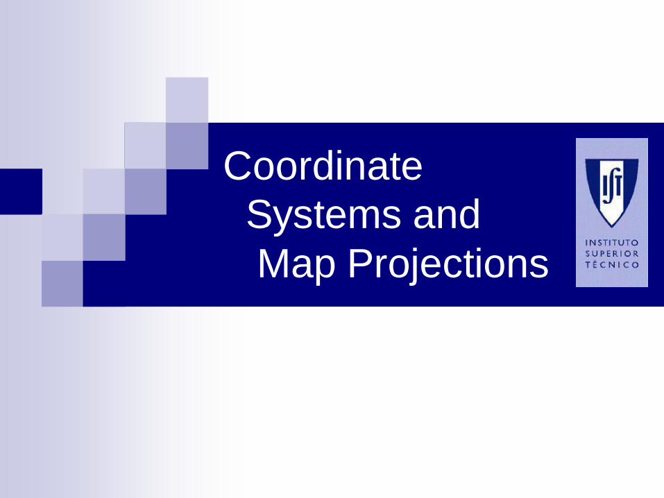
Georeferencing with coordinates
Longitude l and latitude f
Angle from equator: latitude f
Angle east of Greenwich: longitude l
Coordinate systems are based on agreements
Coordinates relative to a „model“ of the earth
Spherical, unprojected coordinate system
Angular coordinates are perfectly suited to the
spherical surface of the Earth
N
S
l
A
Äquator
Nu
l l -M
er i d
i an G
r ee
nw
ich
f

Latitude and Longitude
Coordinates are expressed in degrees,
minutes and seconds (and variations of that).
Position coordinates are based on an angular
distance from a known reference point.
In WGS-84, that reference point is where the
Prime Meridian and Equator intersect.
WGS-84 Latitude/Longitude is perhaps the
predominant coordinate system used in GIS.

0º
0º
•Point of Origin
•Prime Meridian
•Equator
•(Longitude)
•(Latitude)
Latitude and Longitude

•0º, 0º
•Prime Meridian
•Equator
•10º •20º •W 30º •10º •20º •30º E •10º
•20º
•30º
•10º
•20º
•30º
•S
•N
•+
Latitude and Longitude

Latitude
Latitude is comprised of parallels, which are circles around the
earth paralleling the equator.
Parallels are rays that originate at the center of the earth. They
are designated by their angle north or south of the equator.
The equator is 0º latitude, and the north and south poles are at
90º angles from the equator.
The linear distance between parallel lines never changes,
regardless of their position on Earth. That distance is
approximately 111 kilometers per degree, anywhere on Earth.

10º
Parallels of Latitude

10º
10º
10º 1110 kilometers
•10º S
•0º N
•10º N
•20º N
Parallels of Latitude
1110 kilometers
1110 kilometers

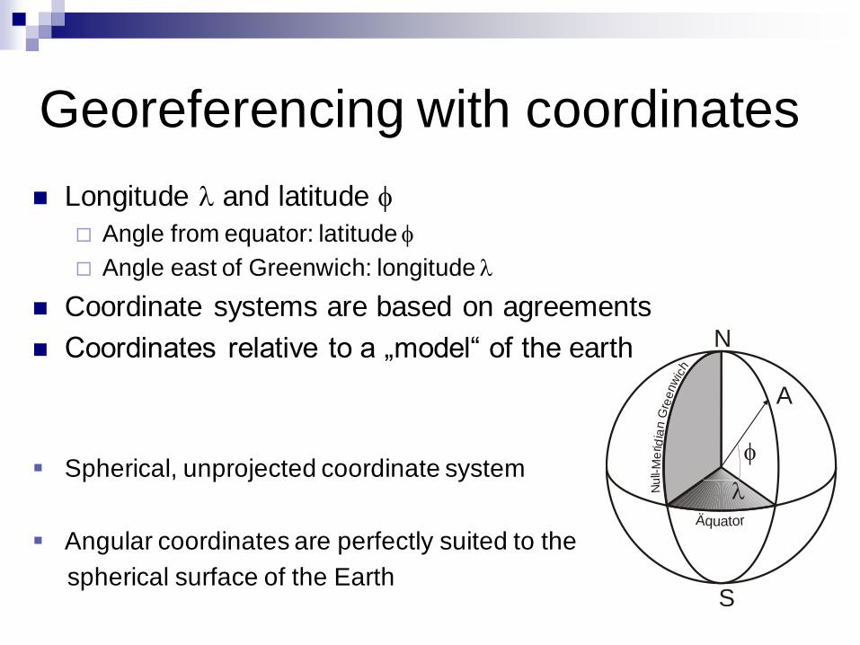
Longitude
Longitude is comprised of meridians that form one-half of a
circle, or plane.
Meridians are rays originating at the center of the earth.
Meridians are designated by their angle west or east of the
prime meridian.
The prime meridian is designated 0º and extends from the
north pole to the south pole through Greenwich, England.
Meridians are angled, and do not parallel each other.
The linear distance between one degree of longitude at the
equator is approximately 111 kilometers.
The linear distance between one degree of longitude at the
arctic circle is about 41.84 kilometers.
10º
Meridians of Longitude

10º
10º
110º W 120º W
1110 Km
740 Km
386 Km
10º
Meridians of Longitude

•30º N
•50º W
•Equator
(0º)
•Prime Meridian
•(0º) •30ºN, 50ºW
Determining Latitude and Longitude

Geographic Coordinate System
Usually a universal coordinate System (lat/lon)
Lat/lon good for locating positions on surface of a globe
Lat/lon not efficient for measuring distances and areas!
Latitude and longitude are not uniform units of measure
One degree of longitude at equator = 111.321 km (WGS-84)
One degree of longitude at 60°latitude = 55.802 km (WGS-84)

Great Circle Distance
On a sphere the shortest path between two
points is given by the great circle distance.
An arc linking two points on a sphere.
The Great Circle Distance (D) on a sphere:
cos D = (sin a sin b) + (cos a cos b cos |c|)
a and b are the latitudes of the respective
coordinates
|c| is the absolute value of the difference of
longitude between the respective coordinates.
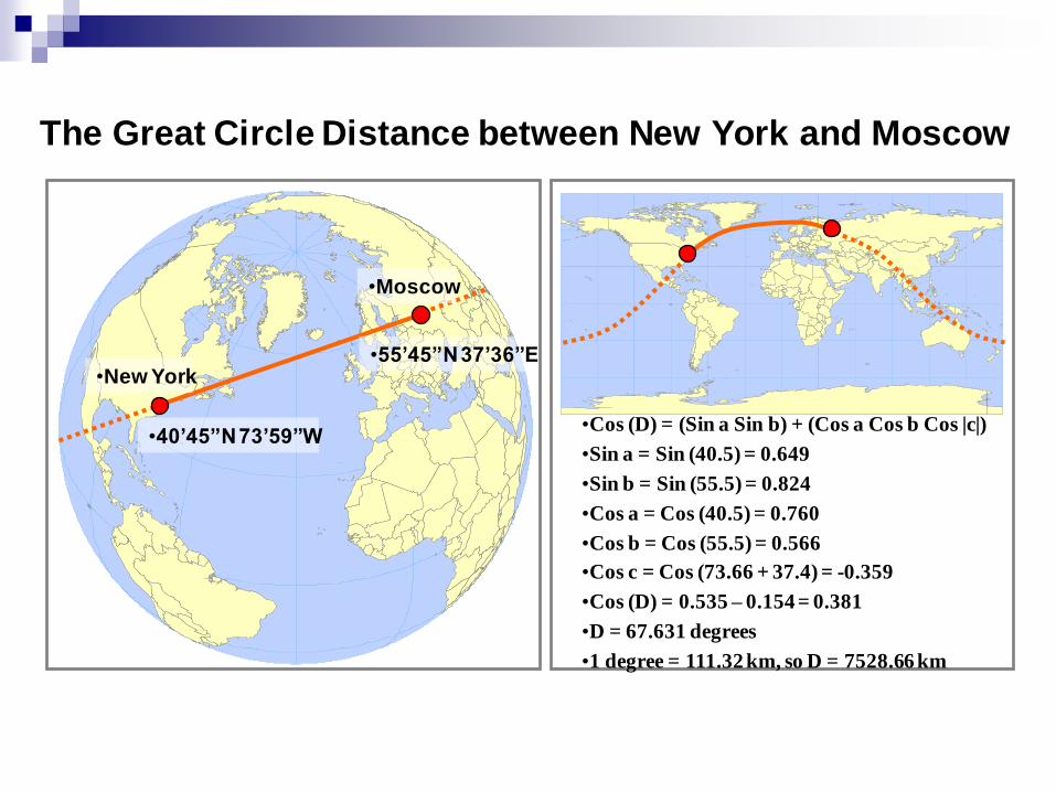
The Great Circle Distance between New York and Moscow
•New York
•Moscow
•40’45”N 73’59”W
•55’45”N 37’36”E
•Cos (D) = (Sin a Sin b) + (Cos a Cos b Cos |c|)
•Sin a = Sin (40.5) = 0.649
•Sin b = Sin (55.5) = 0.824
•Cos a = Cos (40.5) = 0.760
•Cos b = Cos (55.5) = 0.566
•Cos c = Cos (73.66 + 37.4) = -0.359
•Cos (D) = 0.535 – 0.154 = 0.381
•D = 67.631 degrees
•1 degree = 111.32 km, so D = 7528.66 km

The shape of the earth
From sphere to an ellipsoid of rotation (spheroid)
Polar flattening. Meridians are ellipses ellipsoid of
rotation (spheroid).
Ellipticity f of WGS-84 :
a is the distance from the spheroid center to the equator
and b the distance from the center to the pole
Problems due to gravitation field
Ellipsoid of rotation is not an exact iso-surface of
gravitation; therefore, there is a deviation between
coordinates from triangulation and astronomically (GPS)
determined coordinates
298/1
a
baf

The shape of the earth
the geoid: the „true“ shape of the earth
Due to irregular distribution of masses within
the Earth, the geoid is irregular
Geoid is only approximated ellipsoid of rotation
Local fit of ellipsoids
NN
Geoid
EllipsoidEllipsoid
Am
erika
Europa

•Geoid
•Ellipsoid (GPS) •Topographic Surface
•Earth
Ellipsoid & Geoid

Geodetic reference systems
Geodetic Reference System: set of all theoretical
conventions to define a coordinate system for
geodetic purposes. Reference surface (ellipsoid +
rules for handling gedodetic measurements).
Datum: set of parameters defining a coordinate
system, and a set of control points whose
geometric relationships are known, either through
measurement or calculation: origin, direction of
axis, reference point for elevations

Importance of Datum
A datum specifies the earth-model (ellipsoid), and
the origin associated with a particular set of
coordinates.
Datums provide the link between the earth and
coordinate systems.
Without a datum, coordinates have no meaning.
There are many datums used worldwide.

Geodetic reference systems
Reference network: geodetic implementation of reference
system. Computation of coordinates and heights of given
points by means of geodetic surveys.
Usually „grown“ over long time not free of contradiction.
Unique conversion between coordinate systems, e.g. GPS,
to e.g., national geodetic coordinate systems not possible.
Fit by reference points into reference network.
Many available software implementations.

Map projections
Properties of map projections
Projection types (class)
Aspect
Naming of projections
Choice of appropriate projection
Examples of important projections

What are Maps
A map is a two-dimensional representation
of the Earth’s surface.
Maps incorporate projections and datums for
increased accuracy.
All maps distort the earth to some extent.
When using a map with a GPS receiver, the
datum and coordinate system must match.

Properties of map projections
Conformal projections
Preserve local shape grid of intersecting lines of
latitude/longitude on globe are perpendicular (preserve angles)
Equal-area projections
Preserve area of features angle and/or scale may be distorted
Equidistant projections
Preserve distances between certain points; scale is not maintained
correctly on an entire map
True-direction projections
True-direction or azimutal projections map great-circles through the
center point as straight lines

Type of projection
Projection onto geometric surfaces (plane, cone,
cylinder), which can be flattened by unrolling
Mathematical expressions preserving desired properties.
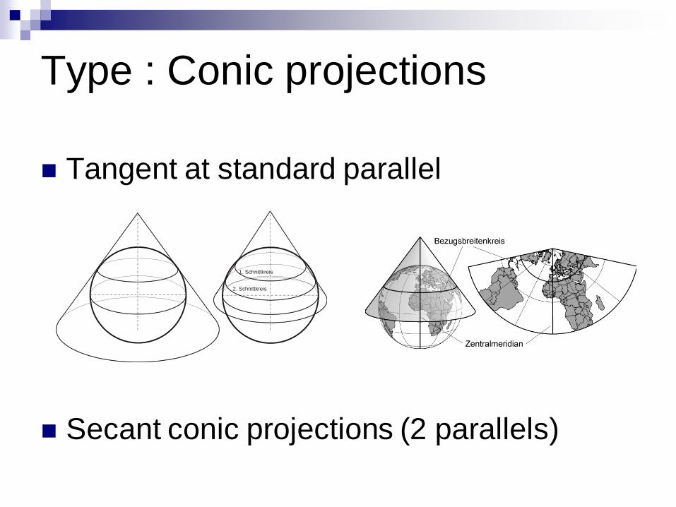
Type : Conic projections
Tangent at standard parallel
Secant conic projections (2 parallels)
1. Schnittkreis
2. Schnittkreis

Type : Cylindrical projections
Tangent or secant
Mercator projection, touches at equator
Transverse Mercator projection touches at
meridian
Schnittkreis
Schnittkreis

Planar (azimuthal) projections
Tangent or secant
Polar, equatorial or oblique
Schnittkreis
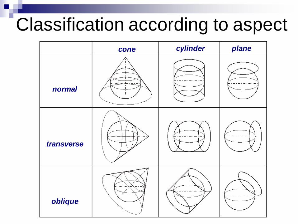
Classification according to aspect
normal
transverse
oblique
cone cylinder plane
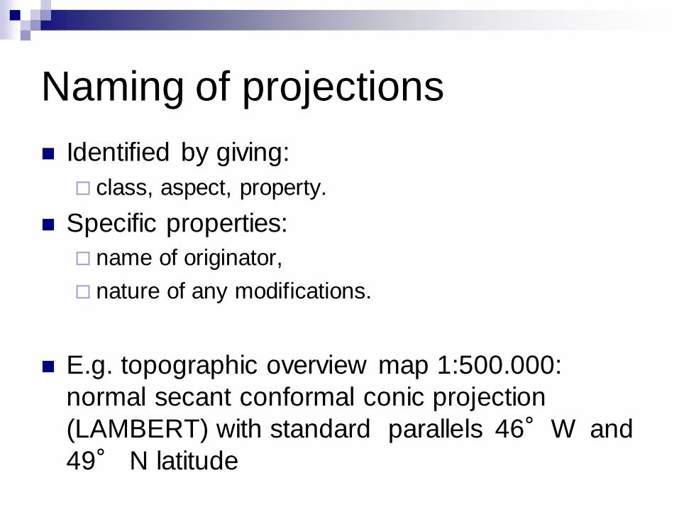
Naming of projections
Identified by giving:
class, aspect, property.
Specific properties:
name of originator,
nature of any modifications.
E.g. topographic overview map 1:500.000:
normal secant conformal conic projection
(LAMBERT) with standard parallels 46°W and
49° N latitude

Selecting a suitable projection
Considerations
How can results be best presented on a map?
For analysis in GIS, all maps must have a common reference
To be able to quantify areas, lengths, etc. the respective accuracy
must be determined
Rules of thumb
Errors and distortions increase from the origin of the projection
towards its edges
In tropical areas cylindrical projections
In temperate latitudes conic projections
Polar regions planar (azimuthal) projections
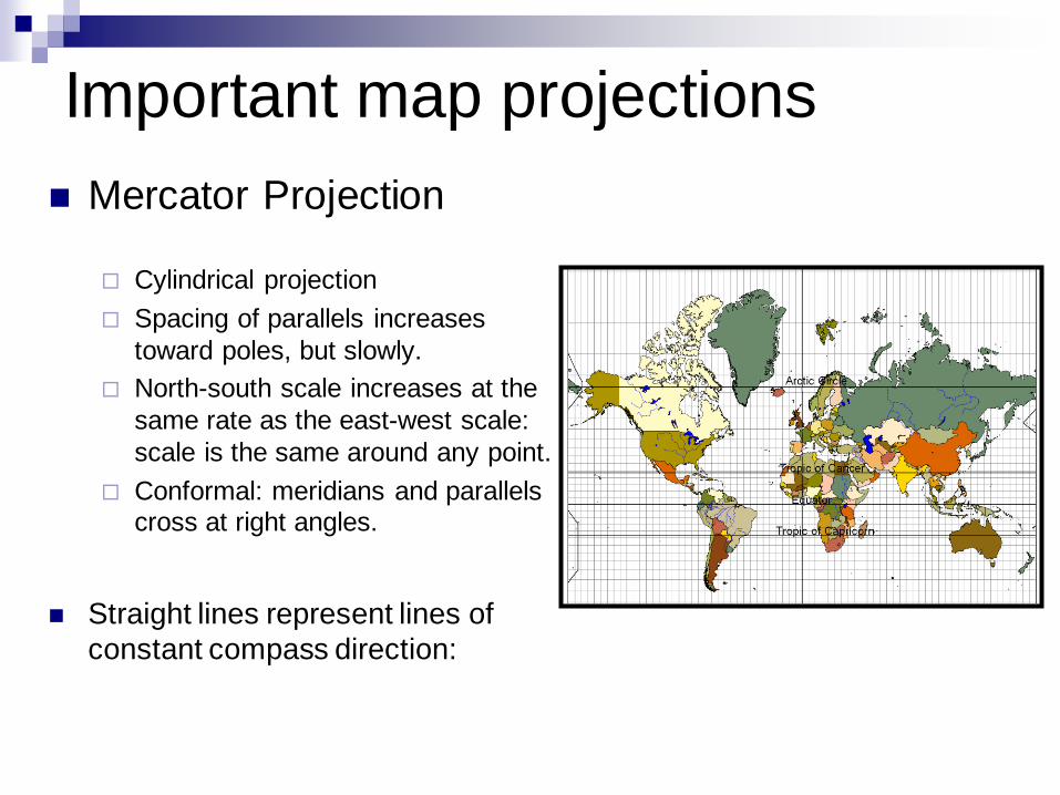
Important map projections
Mercator Projection
Cylindrical projection
Spacing of parallels increases
toward poles, but slowly.
North-south scale increases at the
same rate as the east-west scale:
scale is the same around any point.
Conformal: meridians and parallels cross at right angles.
Straight lines represent lines of
constant compass direction:

Important map projections
UTM (Universal Transverse Mercator) System
Version of transverse Mercator projection.
For cartography between 84°N and 80°S.
Great for small areas
Uses a GRID system (Earth divided into 60 zones)
Coordinates
expressed in
meters!
47°47°
48°48°
49°49°
10°
10°
11°
11°
12°
12°
13°
13°
14°
14°
15°
15°
16°
16°
17°
17°100000
100000
200000
200000
300000
300000
400000
400000
500000
500000
600000
600000
5200000 5200000
5300000 5300000
5400000 5400000

1 60
UTM Grid : 60 Zones, and 20 Latitude Bands
21
•G
•M
•W
•X
80º S
84º N
•D
•C
•E
•F
•H
•J
•K
•L
•N
•P
•Q
•R
•S
•T
•U
•V
Latitu
de B
ands
•21 T
Zones
Important map projections
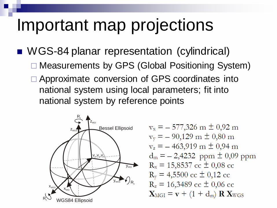
WGS-84 planar representation (cylindrical)
Measurements by GPS (Global Positioning System)
Approximate conversion of GPS coordinates into
national system using local parameters; fit into
national system by reference points
xMGI
yMGI
zMGI
Rx
Rz
Ry
zWGS
yWGS
xWGS
v ,v ,vx y z
Bessel Ellipsoid
WGS84 Ellipsoid

Important map projections
Lambert conformal conic projection
Used frequently for overview maps
Two reference parallels secant to the globe
No distortion along the standard parallels
Conformal projection