Embed Size (px)
Citation preview
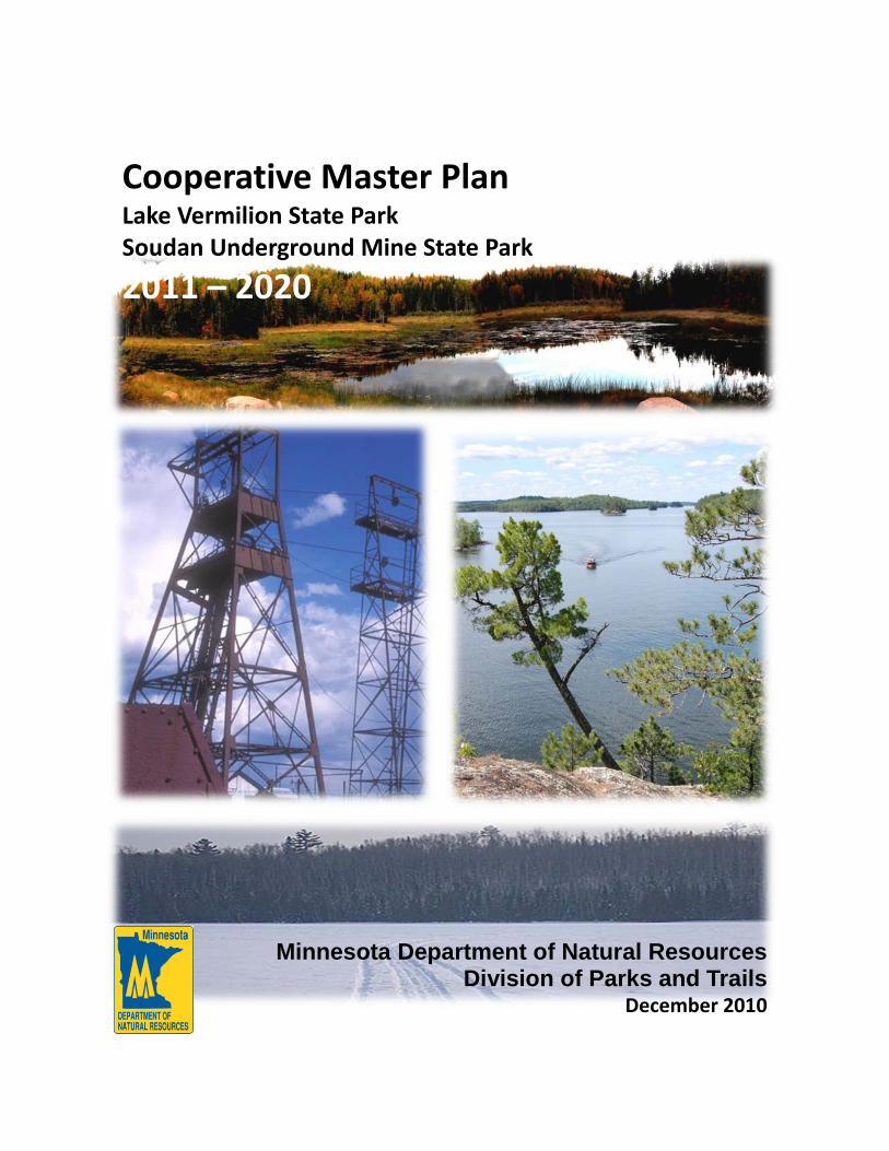
Cooperative Master Plan
Lake Vermilion State Park
Soudan Underground Mine State Park
2011 – 2020
Minnesota Department of Natural Resources Division of Parks and Trails
December 2010


Division of Parks and Trails • 500 Lafayette Road • St Paul MN • 55155
December 17, 2010
On June 8, 2010, current and future generations of outdoor recreationalists received an amazing gift from the people of Minnesota: Lake Vermilion State Park. The purchase followed a nearly three-year negotiation process between the property’s previous owner, U.S. Steel Corporation, and Governor Tim Pawlenty. The deal was ultimately executed because—despite the many challenges the State faces today—in the long run the purchase of this park was the right thing to do for the citizens of Minnesota. The park’s establishment will protect the cultural heritage of American Indians and Iron Range mining; provide an array of “up-north,” lake-oriented recreational opportunities; and protect a representative slice of the natural resources that are found in the Border Lakes Ecological Classification System subsection and the Vermilion River watershed. Because this new state park will be managed in cooperation with its next-door neighbor, Soudan Underground Mine State Park, the Department has written a master plan that explicitly integrates all aspects of management, interpretation and operations between the two parks. The plan also articulates the Division of Parks and Trails’ vision for our “next generation” parks and builds in activities and experiences aimed to inspire participation in outdoor recreation amongst the “next generation” of Minnesotans, who are becoming more diverse and less-connected with the natural world. On behalf of the Department and my planning staff within the Division of Parks and Trails, I want to express our sincere gratitude to the several thousand Minnesota citizens who provided early public input and comments on this plan through the DNR website, and to our dedicated Citizens Advisory Committee, whose members donated hundreds of hours to this planning process. I also express my deep appreciation to my staff at Soudan Underground Mine State Park and the Tower Area Office, in particular Park Manager Jim Essig, and to my staff in the Section of Planning and Development, in particular Project Manager Erika Rivers and Project Planner Jade Templin. These groups pulled together a quality master plan in record time and got to work on providing immediate day-use opportunities in the park as soon as the ink was dry on the purchase agreement. DNR Commissioner Mark Holsten and I thank you all for your dedication, passion and time. I hope each of you will find time in the coming years to enjoy your new “place on the lake.” Sincerely,
Courtland Nelson Director, DNR Division of Parks and Trails
Cooperative Master Plan, 2011 – 2020 Lake Vermilion State Park Soudan Underground Mine State Park Minnesota Department of Natural Resources Division of Parks and Trails This master plan has been prepared as required by Minnesota Statutes (MS), Section 86A.09. For more information on this master plan please contact: Jim Essig, Park Manager DNR Parks and Trails 1379 Stuntz Bay Road Soudan, MN 55782 [email protected] 218-753-2245 Courtland Nelson, Division Director DNR Parks and Trails 500 Lafayette Road St. Paul, MN 55155-4039 651-287-5644
Erika Rivers, Project Manager DNR Parks and Trails 1201 East Highway 2 Grand Rapids, MN 55744 [email protected] 218-999-7914 Paul Maurer, Regional Manager DNR Parks and Trails 1201 East Highway 2 Grand Rapids, MN 55744 218-327-4388
Copies of this plan are available for review at Soudan Underground Mine State Park, 1379 Stuntz Bay Road, Soudan, MN 55782, and the DNR central office, Division of Parks and Trails, 500 Lafayette Road, St. Paul, MN 55155. The plan is also available electronically on the DNR Web site at www.mndnr.gov.
Copyright © 2010 State of Minnesota, Department of Natural Resources
This information is available in an alternative format upon request.
Equal opportunity to participate in and benefit from programs of the Minnesota Department of Natural Resources is available to all individuals regardless of race, creed, color, religion, national origin, sex, marital status, status with regard to public assistance, age, sexual orientation or disability. Discrimination inquiries should be sent to Minnesota DNR, 500 Lafayette Road, St. Paul, MN 55155; or the Equal Opportunity Office, Department of the Interior, Washington, DC 20240.
ACKNOWLEDGMENTS This master plan was shaped by many individuals. The Minnesota Department of Natural Resources gratefully acknowledges their time and contributions. Lake Vermilion State Park Citizens Advisory Committee (CAC) Steve Abrahamson Andrew Brantingham Tim Campbell Skip Drake Ken Gilbertson Mel Hintz Nancy Hanson
Bob Krepps Nancy Larson Bill Latady Mark Ludlow Bob Manzoline Shawn Murphy Jay Schelde
Dave Simpkins Mary Somnis Tim Tomsich Hannah Tuntland Karen Umphress
Lake Vermilion State Park CAC Subcommittee Members and Other VolunteersVerne Adams Rose Berens Brenda Broten Bob Burgess Marshall Helmberger George Hudak Christina Hujanen
Steven Lotz Rod McPeak Marge McPeak Bev Miller Caroline Miner Walt Moe Marcy Moe
Tom Pustovar Conrad Rones Dan Ryan Jessica Schiff Bill Tefft Dan Wendt Jim Willford
DNR Staff Angela Anderson Mark Cleveland Jim Cummings Ron Danielson Nick Entinger Jim Essig Matthew Finneman Shawn Fritcher Doug George Jean Goad Megan Godbold LeRoy Gonsior Gretchen Heaser Harley Hanson Peter Hark Rebecca Holmstrom
Scott Kelling Tony Lenoch Amy Loiselle Cindy Lueth Guy Lunz Mike Magnuson Jim Martin Paul Maurer Christa Miller Karen Myhre Scott Noland Gerda Nordquist Dave Olfelt Thor Pakosz Peter Paulson Larry Peterson
Kelly Pharis James Pointer Gwen Potter Ed Quinn Dave Radford Erika Rivers Tom Rusch Christi Spak Jade Templin John Voges Chris Weir-Koetter Tavis Westbrook Jen Westlund Duane Williams
Thousands of Minnesota outdoor recreation enthusiasts provided input into this plan through their thoughtful public comments.
THANK YOU!
LVSP/SUMSP Cooperative Master Plan, 2011-2020 Page 1
TABLE OF CONTENTS INTRODUCTION
About this Plan ................................................................................................................................. 2 Planning Process ............................................................................................................................. 5 Mission and Key Trends .................................................................................................................. 6
DNR’S “NEXT GENERATION” PARKS
A New Vision .................................................................................................................................... 8 Next Generation Value: Sustainable Development ......................................................................... 8 Next Generation Value: Making Connections.................................................................................. 9 Next Generation Value: Inspiring Participation ............................................................................. 14
NATURAL AND CULTURAL RESOURCES MANAGEMENT
Natural Resource Management ..................................................................................................... 17 Guidance for Natural Resource Management ............................................................................... 22 Cultural Resource Management .................................................................................................... 26 Guidance for Cultural Resource Management .............................................................................. 27
INTERPRETATION AND OUTREACH
Existing Interpretive Services ........................................................................................................ 31 Proposed Interpretive Services ..................................................................................................... 31
RECREATIONAL USE AND VISITOR SERVICES
Existing Facilities ........................................................................................................................... 35 Development and Management Concerns .................................................................................... 36 Proposed Recreational Uses .......................................................................................................... 37 Proposed Development of Visitor Services.................................................................................... 40
LOOKING FORWARD: INTEGRATING OPERATIONS AND OTHER CONSIDERATIONS FOR THE FUTURE
Parks and Trails Operations and Integration ................................................................................. 48 Park Boundaries ............................................................................................................................ 50 Plan Modification ........................................................................................................................... 52
SUPPLEMENTAL INFORMATION
Summary: Master Plan Recommendations ................................................................................... 54 Bibliography of Associated Documents ......................................................................................... 59 Appendix A – Ecological Classification System (ECS) Plant Community Descriptions .................. 60 Appendix B – Species Lists ............................................................................................................. 69 Appendix C – Forestry Management Recommendations ............................................................. 77 Appendix D – Summary of Early Public Input Web-Based Questionnaire .................................... 83 Appendix E – CAC Recommendations ........................................................................................... 95 Appendix F – Summary of and Response to Comments from 30-Day Public Review ................ 102
LIST OF EXHIBITS
Exhibit 1: Side-by-Side, Profiles of Two State Parks......................................................................... 3 Exhibit 2: Tower-Soudan Area Parks and Trails Opportunities ...................................................... 12 Exhibit 3: Land Cover Types ........................................................................................................... 20 Exhibit 4: Significant Areas Map .................................................................................................... 28 Exhibit 5: Proposed Development Areas ....................................................................................... 41
LVSP/SUMSP Cooperative Master Plan, 2011-2020 Page 2
INTRODUCTION About this Plan While this plan meets the requirements for master plans laid out in
Minnesota Statutes (MS 86A.09), it necessarily looks a bit different than those the Minnesota Department of Natural Resources (DNR) has written in the past. This is the Department’s first cooperative plan between two parks, and it addresses a new set of challenges these parks need to address.
Soudan Underground Mine State Park has its principal feature—a National Historic Landmark—some 2,341 feet underground. The park operates one of the most technically and operationally challenging tours in the state, hoisting an average of 33,500 visitors underground each year in restored, 25-square foot cages to explore the geology and culture of 20th-century mining operations. The park also features a series of exploratory open pit mines, a historic district of 143 corrugated steel-sided boathouses and nearly five miles of shoreline on Lake Vermilion. The people of Soudan’s mining town have recreated along this shoreline since the 1880s, and indigenous peoples have lived and quarried the region’s high-quality rock formations for several millennia.
Just next door, Lake Vermilion State Park promises to be a different kind of state park as well. The recently acquired park is positioned to become the first of Minnesota’s “Next Generation” state parks, developed and managed with the highest standards for sustainability. While still providing the experiences that current state park users expect, Lake Vermilion State Park will also provide outdoor recreation adventure programs and opportunities to entice our less-inclined citizens to explore and appreciate Minnesota’s great outdoors. This new park is unique not only in its location on Minnesota’s fifth-largest inland lake, where it boasts five miles of pine-studded shoreline with rock outcrops, but also because it is one of very few state parks where the state has 100 percent ownership interest (i.e., no private in-holdings) and minimal development (i.e., the property has some former timber management roads, but no existing facilities). This “clean slate” situation provides an opportunity to develop a park that embraces emerging technologies both to protect and interpret the park’s resources and to draw in new participants in outdoor recreation.
Located side-by-side, these parks provide an opportunity to bridge the past and the future—in terms of northern Minnesota cultural history, natural resources of the Border Lakes ecological subsection, and current and newly emerging outdoor recreation participants. Making the most of this partnership opportunity requires the DNR to focus its master planning efforts on cooperative and adaptive strategies that explicitly embrace the ecological, recreational and socio-economic matrices in which the parks are situated.
This master plan looks a little different than other DNR park master plans.
Combined, these parks provide a unique opportunity to make important connections between our past and our future.
LVSP/SUMSP Cooperative Master Plan, 2011-2020 Page 3
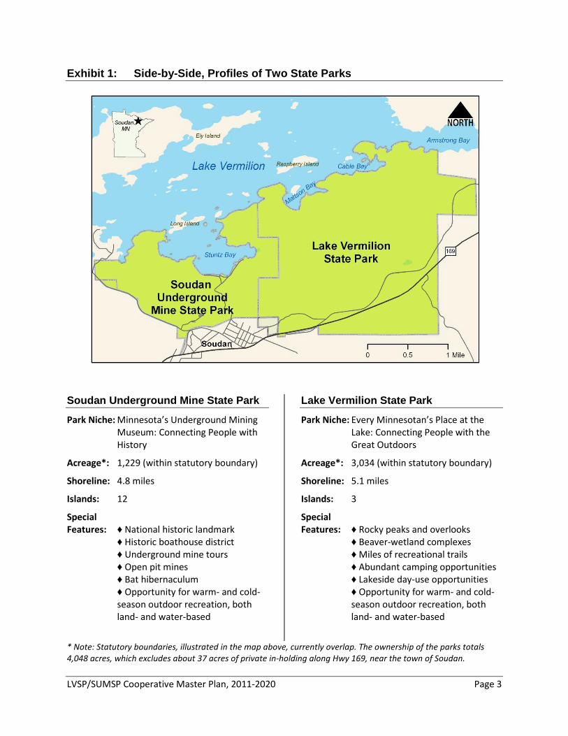
Exhibit 1: Side-by-Side, Profiles of Two State Parks
Soudan Underground Mine State Park
Park Niche: Minnesota’s Underground Mining Museum: Connecting People with History
Acreage*: 1,229 (within statutory boundary)
Shoreline: 4.8 miles
Islands: 12
Special Features: ♦ National historic landmark ♦ Historic boathouse district ♦ Underground mine tours ♦ Open pit mines ♦ Bat hibernaculum ♦ Opportunity for warm- and cold-
season outdoor recreation, both land- and water-based
Lake Vermilion State Park
Park Niche: Every Minnesotan’s Place at the Lake: Connecting People with the Great Outdoors
Acreage*: 3,034 (within statutory boundary)
Shoreline: 5.1 miles
Islands: 3
Special Features: ♦ Rocky peaks and overlooks ♦ Beaver-wetland complexes ♦ Miles of recreational trails ♦ Abundant camping opportunities ♦ Lakeside day-use opportunities ♦ Opportunity for warm- and cold-
season outdoor recreation, both land- and water-based
* Note: Statutory boundaries, illustrated in the map above, currently overlap. The ownership of the parks totals 4,048 acres, which excludes about 37 acres of private in-holding along Hwy 169, near the town of Soudan.
LVSP/SUMSP Cooperative Master Plan, 2011-2020 Page 4
Therefore, this is a cooperative master plan. It is written as both a master development plan for Lake Vermilion State Park, and as an update to the master plan for Soudan Underground Mine State Park. This is important because, in the interest of fiscal and operational efficiency, the DNR intends to manage both parks from one resource and operations management structure. Programs and park amenities will need to be well integrated to provide a quality experience for visitors. The plan is also explicit about centering these two state parks as the recreational hub to other area outdoor recreational opportunities: Bear Head Lake State Park; Bear Island State Forest recreation opportunities; the nearby grant-in-aid, state and regional trails, and state water trails; and the associated federal recreational opportunities in the area—Boundary Waters Canoe Area Wilderness (BWCAW), Superior National Forest and Voyageurs National Park. Finally, the parks will be positioned to collaborate with the Bois Forte Band of Chippewa, community groups, conservation organizations and businesses to connect park visitors with other cultural and recreational opportunities in the area. As such, the parks are envisioned to become a sustainable economic development opportunity for local communities (particularly nearby Tower and Soudan, but also for the more distant Cook, Ely and Biwabik)—helping to re-position the area as a quality northern Minnesota recreational destination.
This is also envisioned as an adaptive master plan. The DNR has owned the Lake Vermilion State Park property for about six months at the writing of this document. The Department was fortunate to have a jump-start on its resource assessment work for the property, having received resource-related information from the previous property owner, U.S. Steel Corporation. The Department also conducted one field season of natural and cultural resource assessment work between May and October of 2010. For Soudan Underground Mine State Park, resource and cultural information has been collected over the course of the park’s 47-year existence, much of it reported in the park’s 2002 Master Plan. While the existing and emerging information is enough to write a well-informed cooperative master development plan today, additional field assessments will continue over the next several years to fill out species lists and guide site-specific development decisions.
Additionally, while this master planning process was designed around a multi-pronged public input process, development concepts that will lead these two parks to become truly “Next Generation” in their design and operation will be dependent on additional market research focused on new and emerging parks and trails users—research that is only just now developing. As these kinds of research emerge and feasibility studies of the concepts outlined here are conducted, the plan will necessarily need adaptation and amendment.
This plan is positioned to be collaborative…
…and is intended to be adaptive.
LVSP/SUMSP Cooperative Master Plan, 2011-2020 Page 5
Finally, the Minnesota DNR has identified three “game-changing” trends that are currently influencing natural resource management in Minnesota and across the nation (pp. 6-7). The Department’s A Strategic Conservation Agenda, 2009-2013 addresses how the State of Minnesota will begin to meet and address these trends in our natural resource management activities. Lake Vermilion and Soudan Underground Mine state parks will adapt their management and operations to address these trends over time, which may result in changes and amendments to this cooperative master plan.
Planning Process The planning processes contributing to this cooperative master development plan really began almost a decade ago with the writing of the Soudan Underground Mine State Park Master Plan (2002). The plan included discussion of the purchase of the adjacent U.S. Steel working forestlands, which in June 2010 were acquired and became Lake Vermilion State Park. Many of the recommendations in this current plan related to Soudan Underground Mine State Park build on that park’s original master plan, which was developed through an open public process utilizing a citizens advisory committee, a resource management advisory team, and a standard master plan public comment period and open house.
Governor Tim Pawlenty initiated the proposal to create Lake Vermilion State Park in July 2007. Planning for Lake Vermilion State Park began in September 2007, when DNR Commissioner Mark Holsten established a task force to make recommendations on the issues citizens felt needed to be addressed in the park master planning and natural resource assessment processes. Following a series of task force meetings, Internet-based public input opportunities and a public open house, the group ultimately produced an eight-page document of recommendations that helped successfully pitch the idea of a new state park to the Minnesota State Legislature. The park was authorized in May 2008, and the Legislature provided $20 million in bonding authority for its purchase.
This Cooperative Master Plan was built on the previous work of the Commissioner’s Task Force and was further developed through an open public process that included:
• Natural and cultural resource assessment work (literature and field research)
• An internal DNR park master planning effort that was conducted in consultation and collaboration with a 12-member project delivery team and a 10-member executive planning team
• Consultation with and recommendations from a 19-member Citizens Advisory Committee, which was comprised of tribal, local and statewide interests (See Appendix E)
Amendments will be made as new information becomes available.
This plan emerged from an open public process that built on the work of two previous planning efforts.
LVSP/SUMSP Cooperative Master Plan, 2011-2020 Page 6
• An early public input questionnaire on the DNR Web site (and also available at the Minnesota State Fair), which had more than 2,900 respondents (See Appendix D)
• A 30-day public comment period, as required by MS 86A.09 • A Web-based draft master plan review questionnaire, to help citizens
focus their public comments on critical issues and concerns (See Appendix F)
• Public open houses to give participants an opportunity to ask questions and provide input about the draft master plan, as required by MS 86A.09 (See Appendix F)
The recommendations in this plan are the result of this partnership-based planning process. The plan provides basic management and development direction for the two parks and is not intended to provide specific management or development details. These details will be determined at the discretion of the DNR Division of Parks and Trails development and operations staff, under the direction of DNR Commissioner and Division leadership teams.
Mission and Key Trends The DNR’s mission and strategic management approach are described in
A Strategic Conservation Agenda, 2009-2013, which the DNR has used here to articulate how Lake Vermilion and Soudan Underground Mine state parks fit into Minnesota’s broader recreational and natural resource management frameworks.
The mission of the Minnesota Department of Natural Resources (DNR)
is to work with citizens to conserve and manage the state's natural resources, to provide outdoor recreation opportunities and to provide for commercial uses of natural resources in a way that creates a sustainable quality of life.
The DNR has identified three key trends that impact Minnesota’s natural
resources and the Department’s efforts to achieve its mission. Lake Vermilion and Soudan Underground Mine state parks will play a role in the Department’s response to the key trends.
The first key trend is changing participation in outdoor recreation, which
is declining on a per capita basis in Minnesota and across the country. One of the main reasons for these declines is that young adults and families with children are not participating at the same levels as they have in the past. In addition, as Minnesota’s population becomes older, more urban and more diverse, demands for outdoor recreational opportunities will continue to change.
Lake Vermilion and Soudan Underground Mine state parks will be places
where the Department can focus on its strategic directive to “connect people to Minnesota’s great outdoors.” Programs and facilities will be
The DNR mission is challenged by three key trends influencing natural resource management:
1. Changing participation in outdoor recreation
LVSP/SUMSP Cooperative Master Plan, 2011-2020 Page 7
designed to attract young people, families and people of color and teach them how to participate in a variety of outdoor recreation activities.
The second key trend involves changes related to energy and climate.
Concerns about energy security, the cost of fuel and climate change have led to new national and state standards for energy efficiency and conservation-based alternatives to fossil fuels. Climate change will alter how the DNR manages Minnesota’s land and water resources in the future.
Lake Vermilion State Park will demonstrate sustainability and efficiency
in design and operation of facilities—reducing energy use, protecting water resources, utilizing alternative energy sources and sharing equipment and other operations resources with other units. The new state park will also add to the base of resource-focused managed lands that can be used for monitoring changing conditions and applying research findings for climate change mitigation and adaptation efforts. Meanwhile, the DNR is also committed to identifying areas where Soudan Underground Mine State Park can also decrease its energy consumption over time. As such, any new infrastructure in the parks will strive for “net zero” energy consumption and emissions on an annual basis, as cost, site and design conditions allow.
Finally, the third key trend recognized by the DNR involves landscape
changes related to growth and development. Minnesota is projected to grow by more than one million people in the next 20 years. The resulting landscape changes will challenge the Department’s efforts to restore and maintain fish and wildlife and provide clean water, quality outdoor recreational opportunities and sustainable economic uses of natural resources.
Collaboratively, Lake Vermilion and Soudan Underground Mine state
parks provide a new opportunity for the Department to preserve and restore natural and cultural resources while also providing visitors with learning and recreational experiences in Minnesota’s outdoors. Together, the parks encompass more than 4,000 acres of land, roughly 10 miles of shoreline and important cultural histories of the Lake Vermilion area that will be protected and available to the public.
2. Changes related to energy and climate
3. Landscape changes related to growth and development
LVSP/SUMSP Cooperative Master Plan, 2011-2020 Page 8
DNR’S “NEXT GENERATION” PARKS A New Vision While the development of Lake Vermilion and Soudan Underground Mine
state parks provides opportunities to forward the strategic directions identified for all three of these key trends, the Division of Parks and Trails is probably the best-positioned DNR Division to address the first key trend identified: declining participation in outdoor recreational activities. When the former DNR divisions of Parks and Recreation and Trails and Waterways merged in 2008, the new division created a vision statement that embraces the Department’s strategic imperative to reverse the decline in outdoor recreation participation:
The vision of the Division of Parks and Trails is to create unforgettable
park, trail and water recreation experiences that inspire people to pass along the love for the outdoors to current and future generations.
Operationally, this vision has become the seed for the concept of
developing Lake Vermilion State Park—and by association, Soudan Underground Mine State Park—into “Next Generation” state parks. The defining values of Next Generation parks include emphases on sustainability, connectedness and inspiring participation. These parks will serve as pilot parks, exploring new ideas and approaches that, if successful, can be applied to other state parks over time.
Next Generation Value: Sustainable Development Lake Vermilion and Soudan Underground Mine state parks will strive to
become models of sustainable development. The DNR has identified five guiding principles that will govern the emphasis on sustainability in these two parks.
First and foremost, new development will protect the natural, cultural and economic assets that exist with the parks and surrounding communities. Embracing the principles of conservation design, the parks’ development and re-development will recognize the real value of these assets and make planning and development decisions that support conservation of these assets for future generations. Development will embrace best management practices for shoreland management—avoiding, minimizing and mitigating impacts within the Vermilion River watershed. Development will meet or exceed setback standards; strive to minimize impervious surfaces; treat storm water runoff on site; use natural vegetative buffers to infiltrate runoff and screen much of the parks’ development from the lake; minimize disturbance and fragmenting of riparian and aquatic habitats; and use approaches best suited for on-site sewage treatment.
The parks will become models for sustainable development that embrace the principles of conservation design.
The DNR vision for both of these parks is to create unforgettable, inspiring experiences.
LVSP/SUMSP Cooperative Master Plan, 2011-2020 Page 9
Buildings and operations will model energy efficiency by utilizing renewable energy sources whenever feasible and striving for “net zero” energy consumption and emissions on an annual basis for new development. Retrofits for existing Soudan Underground Mine State Park infrastructure will be explored and implemented when practical. Park development and operations will seek opportunities to provide local economic and social sustainability, such as using local resources and labor to the maximum extent possible. Minimizing the parks’ overall carbon footprint will be an explicit goal of all design and operational decisions. When feasible, the DNR intends to use building materials in parks’ designs that are local, recycled or reused, low maintenance and durable. Park development and programs will focus on encouraging healthy, active lifestyles for both day- and overnight- park users. Activities and programs will focus on how participation in outdoor recreational activities can help maintain healthy bodies and minds. Food and beverage offerings will emphasize healthy, local options. And, while recreational trails will provide an alternative to vehicle travel to major park facilities, the DNR is committed to meeting the needs of an aging population by making park programs and facilities open and available to users of all abilities.
Because of its relatively undeveloped status, Lake Vermilion State Park can be developed from its inception with the highest standards of sustainability. Challenges to sustainable development mainly exist from site limitations—bedrock and thin soils, west-northwest prevailing winds and building orientations (i.e., toward the lake) that will challenge energy efficiency efforts. Soudan Underground Mine State Park is challenged by aging infrastructures, most of which are contributing elements to the National Historic Landmark. Efforts to model sustainability through retro-fitting will require careful coordination with the Minnesota Historical Society’s State Historic Preservation Office (SHPO).
Next Generation Value: Making Connections Lake Vermilion and Soudan Underground Mine state parks will also be
well connected to the broader landscape, recreational and social-economic matrices in which they are situated. In other words, the parks will: • Recognize their place within nested watersheds and Ecological
Classification System (ECS) subsections and manage resources accordingly;
• Connect users to other area outdoor recreational opportunities, acting as the hub of a recreational wheel with many spokes;
• Support local economic and social well-being by explicitly connecting local communities with the parks’ tourism opportunities.
The parks will be well connected with the broader matrices in which they are situated…
LVSP/SUMSP Cooperative Master Plan, 2011-2020 Page 10
In resource management plans and activities, the DNR will continue to recognize Lake Vermilion and Soudan Underground Mine state parks’ place within nested watersheds and Ecological Classification System (ECS) subsections and manage resources accordingly. Lake Vermilion and Soudan Underground Mine state parks are located primarily in the Border Lakes ECS subsection, with the southeastern corner of Lake Vermilion State Park falling within the Nashwauk Uplands subsection (See Appendix A for descriptions). The Border Lakes ECS subsection is characterized by lakes and rocky ridges with glacially-eroded bedrock and poor soils. The Nashwauk Uplands subsection includes rolling till plains and moraines and flat outwash plains formed by the Rainy Lobe glacier, with locally exposed bedrock in the end moraines and a narrow bedrock ridge known as the Giants Range. Small bogs and potholes are also common.
The parks are also squarely situated within the Vermilion River Major
Watershed (DNR Level 04, HUC 08), where waters ultimately flow northwest through the Rainy River Basin (Namakan Lake Sub-Basin) on their way to Hudson Bay. The majority of the parks’ lands fall within the Lake Vermilion minor watershed, with the southeastern corner of Lake Vermilion State Park edging into the East Two Rivers minor watershed, and the southernmost area of Soudan Underground Mine State Park edging into the “unnamed” minor watershed located immediately to the east of the West Two Rivers minor watershed.
As natural resource management decisions are made within these parks,
they will refer to the larger landscape and watershed planning efforts underway within the State of Minnesota, primarily Subsection Forest Resource Management Planning (SFRMP), Total Maximum Daily Load (TMDL) watershed-level planning and the state’s Comprehensive Wildlife Conservation Strategy.
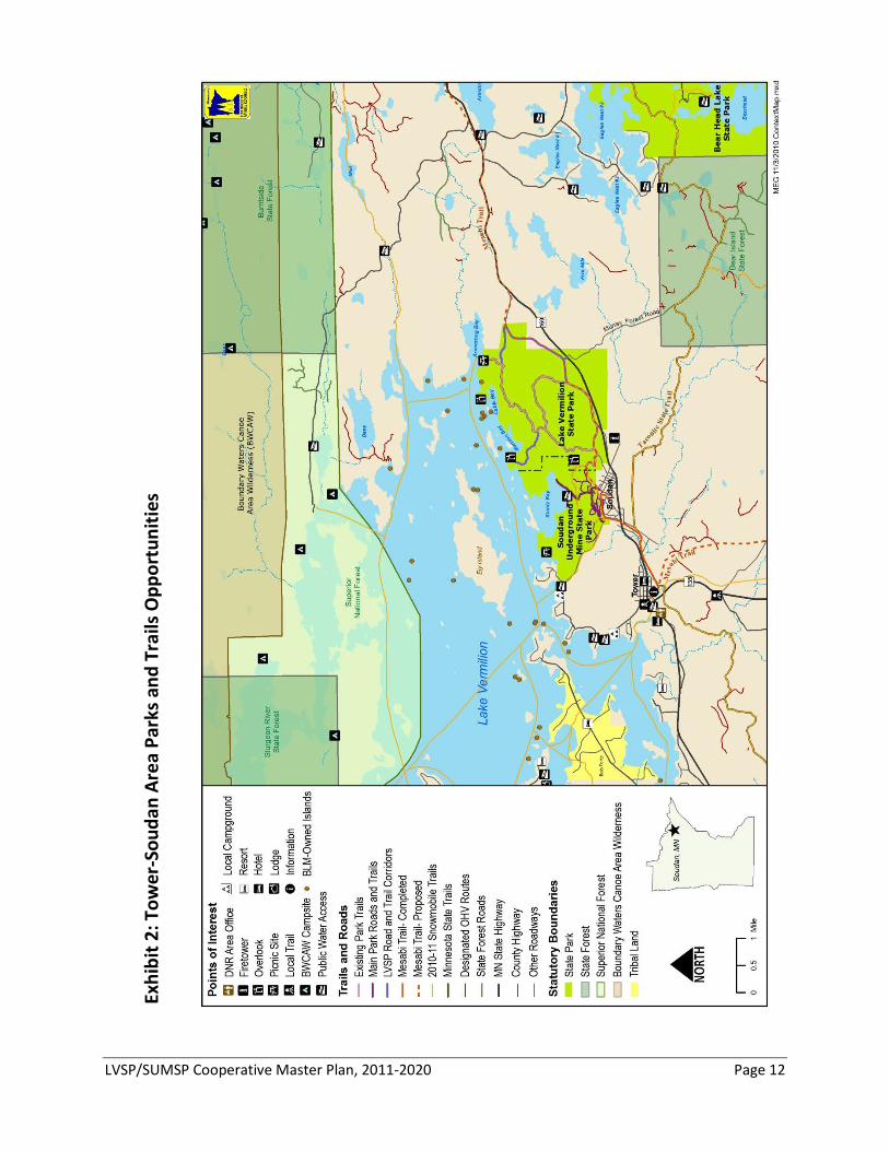
Lake Vermilion and Soudan Underground Mine state parks will act as
the hub of a recreational wheel with many spokes, connecting users to many of the areas outdoor recreation opportunities. The area surrounding Lake Vermilion State Park State Park provides a range of recreational opportunities, including other state-managed units, federally managed units and opportunities provided by local governments and community groups (See Exhibit 2, pg. 12). These opportunities will help position both parks as a year-round outdoor recreation destination.
Nearby state parks and state recreation areas include the following:
• Bear Head Lake State Park (about eight miles from the parks) • McCarthy Beach State Park (about 45 miles from the parks) • Iron Range Off-Highway Vehicle Recreation Area (about 30 miles
from the parks)
…The Landscape Matrix
…The Outdoor Recreation Matrix
LVSP/SUMSP Cooperative Master Plan, 2011-2020 Page 11
State forest recreation managed by the Division of Parks and Trails in the area includes trails, campgrounds and day use areas (DUA): • Hinsdale Island Campsites and Wakemup Bay Campground and DUA
(on Lake Vermilion) • Ash River Campground and Woodenfrog Campground and DUA
(Kabetogama State Forest) • More than 95 miles of motorized-use roads and trails three miles to
the southeast of Lake Vermilion State Park (Bear Island State Forest) Several state trail opportunities pass near the state parks, including the
following: • Taconite State Trail is a natural surface trail for most of its length,
supporting hiking, biking, horseback riding and some limited ATV use in the summer and snowmobiling in the winter.
• Arrowhead State Trail is a natural surface trail with snowmobiling as its main use.
• Three state water trails, which support canoeing and kayaking, are located near the park: Vermilion River, Little Fork River and St. Louis River
Federally managed recreational opportunities in the area surrounding
the parks include the following: • Voyageurs National Park • Boundary Waters Canoe Area Wilderness/Superior National Forest • North Country National Scenic Trail
St. Louis County and local communities support recreational
opportunities near the parks as well, including the following: • McKinley Park, managed by Breitung Township, and Hoodoo Point
campgrounds, managed by the City of Tower • Mesabi Trail, managed by the St. Louis County Rail Authority • Giant’s Ridge Golf and Ski Resort, managed by Iron Range Resources • Grant-in-aid snowmobile, off-highway vehicle and ski trails, managed
by local clubs Finally, Lake Vermilion itself hosts a variety of outdoor recreation
opportunities in its own right, including: • 39,271 acres of public water with 16 public water accesses • 15 species of fish that provide some 587,000 hours of angling
opportunity each year
LVSP/SUMSP Cooperative Master Plan, 2011-2020 Page 12
Exhi
bit 2
: Tow
er-S
ouda
n Ar
ea P
arks
and
Tra
ils O
ppor
tuni
ties
LVSP/SUMSP Cooperative Master Plan, 2011-2020 Page 13
By connecting and partnering with the matrix of local communities,
Lake Vermilion and Soudan Underground Mine state parks can help these communities create sustainable local economies. The parks also provide an opportunity to strengthen the DNR’s relationships with the Bois Forte Band of Chippewa, local communities, schools, civic groups and other organizations. The DNR has a significant presence in the local area, with the DNR Area Office in Tower and acres of state lands in various DNR ownerships—State Forests (four in St. Louis County), Scientific and Natural Areas (eight in St. Louis County), Wildlife Management Areas (16 in St. Louis County), and Parks and Trails (five parks in St. Louis County; hundreds of miles of trails). Given their proximity, the parks will seek to build stronger partnerships with the Bois Forte Band and local community groups and businesses in Tower and Soudan.
The Bois Forte Band of Chippewa has a centuries-long presence on the
lands surrounding Lake Vermilion. In addition to its reservation on Lake Vermilion, the Bois Forte Band’s tribal lands include lands around Nett Lake in St. Louis and Koochiching counties and Deer Creek in Itasca County. The Bois Forte Band operates the Bois Forte Resort and Marina and the Heritage Center and Cultural Museum, which tells the story of the Bois Forte Band, including their history living on Lake Vermilion. The Heritage Center and Fortune Bay Resort Casino are located on tribal lands west of Tower. The Division of Parks and Trails communicates with the Bois Forte Band concerning cultural resource issues in both parks and currently works cooperatively with the Band to monitor islands in Lake Vermilion that are owned by the Bureau of Land Management (BLM).
The communities of Tower and Soudan have a close connection with the
mining history of the area, especially with Soudan Underground Mine. Soudan was founded as a company town—in the beginning, the mining company (originally Minnesota Iron Mining Company) and the community were almost indistinguishable. The company managed the settlement and built the municipal infrastructure, houses, a hospital, a community center and a sawmill. Tower grew independent of the mine company, but still served the mine and its workers. The mine brought people to these communities from all over the world.
With the creation of Lake Vermilion State Park, the DNR anticipates
building on current partnerships and creating new opportunities to work with local partners including: • Cross-promoting tourism opportunities with local communities,
businesses and the Bois Forte Band • Requesting proposals for vendor or concessionaire opportunities in
the operation of the state parks • Working with the Bois Forte Band to ensure the continued protection
(and where appropriate, interpretation) of cultural resources and traditional practices
…The Local Community Matrix
LVSP/SUMSP Cooperative Master Plan, 2011-2020 Page 14
• Partnering with local schools to provide interpretive opportunities about outdoor recreation, natural resources and Minnesota history
• Continuing to partner with the University of Minnesota on underground scientific research projects.
Next Generation Value: Inspiring Participation Lake Vermilion and Soudan Underground Mine state parks will inspire
enthusiasm for outdoor recreation activities among emerging and existing parks and trails users. Combined, the two parks offer more than 4,000 acres of land-based outdoor recreation opportunities, and 10 miles of shoreline and 15 parks-owned islands from which to launch into more than 39,000 acres of water-based recreational opportunities. The northeastern region of the state boasts some of the best all-season outdoor recreational opportunities available in Minnesota—from warm-season hiking, biking, horseback riding, OHV riding, boating and paddling to cold-season hunting, skiing, snowshoeing, dog sledding and snowmobiling. Lake Vermilion also provides outstanding year-round fishing and wildlife-watching opportunities. The opportunity and challenge for the development of these two parks within the “Next Generation” paradigm is to make these opportunities appealing to—and easily attainable for—new and emerging parks and trails users, while still respecting the state parks statutory intent (MS86A.05) and continuing to provide the kinds of visitor experiences that will retain our existing parks user base (a core group with significant representation from aging baby boomers). The DNR has identified six key strategies for encouraging outdoor recreation participation in the parks.
First, the Division of Parks and Trails needs to continue its research into
changing perspectives on recreational use and the outdoors. While the DNR has conducted considerable research on current state park visitors and Minnesotans as recreationalists in general, our research on the emerging markets of state parks and trails users is still in its early stages. As such, the Division of Parks and Trails intends to do further research on both what emerging parks and trails users desire from their experience, as well as how DNR and our recreation partners can provide those experiences. In particular, the Division of Parks and Trails seeks to better understand: • What will attract “disinclined” youth, with little outdoor recreational
experience, to come to these state parks? • What barriers exist that prevent current non-users and
underrepresented groups from coming to these parks—people of color, lower-income groups, young families and recent émigré’ groups?
• What kinds of experiences our existing user base, which continues to age in concert with the general U.S. population, will expect in coming years?
Understand our customers…
LVSP/SUMSP Cooperative Master Plan, 2011-2020 Page 15
Second, the parks will attract the younger demographics by providing
age- and resource-appropriate adventure and skill-building areas and programs. Areas within the park will be devoted to providing space for outdoor adventure and skill building. Adventure-area activities being considered include a ropes course, bouldering, a scenic zipline, interpretive treehouses, natural play areas, an archery skills trail, a mountain biking skill area and physical fitness trails. Programs being discussed include clinics for outdoor skill building (archery, fishing, camping, paddling, snowshoeing, hiking, remote outdoor experiences) and nature observation (nature photography, journaling, birding, astronomy). Programs already exist for some of these activities and can be expanded to Lake Vermilion and Soudan Underground Mine state parks. The parks will also seek to create skill-building linkages for motorized recreation in the Bear Island State Forest, with nature and skill-building clinics offered in collaboration with parks interpretive staff and the Iron Range OHV Recreation Area, respectively. The final determination about what specific kinds of adventure and skill-building opportunities will be offered will follow additional research.
Third, the parks will use emerging technologies to connect people with
outdoor recreation and the parks’ cultural and natural resources. Wireless technologies are transforming the way outdoor recreation participants receive and use information—from deciding where to go and planning their trips to navigating and learning about the things they see and hear when they are afield. Social networking holds huge promise for inspiring younger users to visit parks and explore trails. Smart phone technologies provide endless opportunities for making reservations, providing services and reaching people with interpretative messages. Global positioning technology can provide reassurance to less-experienced users. Lake Vermilion and Soudan Underground Mine state parks will embrace the opportunities that emerging technologies provide and use them to bring existing and emerging users into the parks. The purpose of embracing emerging technologies is to focus the technology on providing and enhancing quality recreational experiences and connecting people with the outdoors. Importantly, this also includes minimizing the impact of technology on other park visitors who are seeking “unplugged” experiences and taking care not to replace “real” outdoor experiences with digital ones.
Fourth, the parks will welcome emerging and existing users by providing
multiple levels of experience, accessibility and programs—from semi-primitive to full visitor amenities. As more people come to parks with lower levels of experience, Lake Vermilion and Soudan Underground Mine state parks will need to provide a variety of entry points to outdoor recreation activities—for both day use and overnight accommodation. As the existing parks user base continues to age, they will seek a higher level of amenities for overnight accommodation and greater accessibility for park attractions. Meanwhile, the emerging users in the younger age demographics will seek a variety of experiences—from the uninitiated
Provide adventure and build outdoor skills…
Embrace emerging technologies…
Provide opportunities for multiple levels of experience…
LVSP/SUMSP Cooperative Master Plan, 2011-2020 Page 16
who will seek organized campground facilities and beginner-level outdoor recreation activities, to the adventuresome, who will seek remote overnight experiences and challenge areas. The two parks together will provide a combination of user experiences to accommodate this increasingly diversified clientele.
Fifth, the parks will seek to provide opportunities for warm- and cold-
season recreation. Previous development in and visitation to Minnesota’s state parks focused primarily on the warm-season seasons. However, given the Lake Vermilion area’s bustling winter recreation opportunities—ice fishing, snowmobiling, skiing, snowshoeing and dog sledding—it is appropriate to design Lake Vermilion State Park to be a year-round outdoor recreation destination. As wintertime visitorship to Lake Vermilion State Park develops, demands for cold-season tours will increase at Soudan Underground Mine State Park as well.
Sixth, Lake Vermilion and Soudan Underground Mine state parks will
strive to provide inspiring and unforgettable experiences that have the potential to change peoples’ lives and life-styles. As the DNR endeavors to bring new users to parks and trails across the state, the Department needs to maintain its high level of facility maintenance and natural resource management to ensure that these newcomers have a quality experience. This will be especially helpful for first-time users, who may come to the parks apprehensive about outdoor recreation activities. In order to be welcoming of diverse user groups, the concept of “quality service” in the Next Generation paradigm needs to include diversity in the parks’ staff, services, natural resources and types of experiences. At the same time, the DNR will also need to ensure maximum efficiency within its operations—exploring self-service amenities and using technology to create non-personal interpretive opportunities (e.g., self-guided audio tours via smart phones).
Be a warm- and cold-season destination…
Provide unforgettable experiences that are life-changing.
LVSP/SUMSP Cooperative Master Plan, 2011-2020 Page 17
NATURAL AND CULTURAL RESOURCES MANAGEMENT
Natural Resources Management DNR natural resource staff made significant progress during the summer
of 2010 to characterize the natural resources present on the Lake Vermilion State Park property and to identify the features most in need of protection and management as the parks are developed. In addition to characterizing and mapping vegetation, surveys were conducted to locate rare plants and animals and to delineate significant fish spawning and emergent aquatic vegetation in Lake Vermilion. Consultations also occurred with Bois Forte tribal elders and DNR foresters and fisheries biologists.
Natural resource assessment work has been conducted at Soudan
Underground Mine State Park over the course of more than four decades in state ownership, most recently in the years preceding that park’s 2002 master plan.
The parks are primarily located in the Border Lakes ECS subsection, a landscape characterized by lakes and rocky ridges, glacially eroded bedrock and poor soils. Long east-west oriented lakes, such as Vermilion, occupy about 13% of the surface area within the subsection. Historic forest types on uplands were mostly aspen-birch, aspen-birch-conifer, and on dry sites, jack pine barrens.
George Stuntz, an 1880 land surveyor in the Tower and Soudan area, provided one of the first written descriptions of the landscape: "This land is at the east end of Vermilion Lake and is generally rocky with some very fertile levels in the valleys. There are several ranges of bluffs and hills in the southeastern part showing veins of iron ore on the islands. In the northern part there are numerous quartz veins carrying iron pyrites….Extensive fires have raged in former years, these burnt districts are now growing up rapidly with young birch, spruce, aspen and other kinds of timber.”
The landscape described by Stuntz is in many ways similar to what is found within these parks today.
The parks are subject to the strong continental weather patterns that influence all of Minnesota. The park is influenced by cold Arctic air during winter months and is frequently dominated by hot air masses from the Gulf of Mexico during the summer months. Total annual precipitation in the Soudan area is approximately 30 inches with an average growing season of 90 to 110 days, and an annual mean temperature of 49 degrees F.
The parks are primarily located in the Border Lakes ECS subsection.
LVSP/SUMSP Cooperative Master Plan, 2011-2020 Page 18
The topography of the area is characterized by rock ridges and steep bluffs, with lakes and wetlands in the intervening depressions. Elevation within the parks varies from 1,358 feet above sea level at Lake Vermilion to 1,630 feet above sea level (near the No. 8 Shaft Complex).
The underlying bedrock formations of the parks are estimated to be more than 2.7 billion years old. The formations are an iron-bearing metamorphic formation and a metamorphosed sedimentary rock formation; they were created by volcanic activity at the bottom of an ancient ocean.
The ore bodies in the parks are mostly hard and dense bluish hematite and are exceptionally high-quality material. The iron ore of the Vermilion Range district was first “discovered” in 1850; however, serious exploration for iron did not start until 1875. Substantial deposits remain despite 80 years of mining. Deposits of other minerals such as nickel, lead, gold, silver and zinc are likely present as well. The State of Minnesota holds the mineral rights within the parks. Some rock from the Soudan Mine and in the immediate vicinity is known to contain levels of sulfides that create acidic, mineral-rich runoff when exposed to the elements.
An exposure of the Soudan Iron Formation is on the top of Soudan Hill, east of Stuntz Bay Road. The exposure illustrates significant characteristics of the formation’s composition—alternating bands of steely-gray hematite, white to pink chert and red jasper. The exposure also displays three distinct geological processes—folding, mineralization and glacial erosion—that shaped and formed the outcrop. The site of this exposure is a Minnesota DNR Natural Heritage Program Registry site and is “very significant in a nationwide or worldwide context.” Other exposures of this type and quality are within Lake Vermilion State Park as well.
Most of the parks’ upland soils consist of very shallow loam over bedrock, characterized by numerous areas of exposed rocks. For specific details regarding the soils within the parks and St. Louis County, refer to the U.S. Department of Agriculture Natural Resources Conservation Service’s Soil Survey.
Groundwater seeps into the Soudan Mine at several levels and is
continuously moved to the surface by a series of pumps. Water removal is necessary to maintain the integrity of the mine, and that discharge requires a permit from the Minnesota Pollution Control Agency. At Soudan, water dissolves copper and cobalt as it moves through the rock; levels of copper and cobalt measured in the water as it is pumped from the mine exceed current standards for surface discharge. DNR is currently treating this discharge and is engaged in ongoing efforts to develop a workable long-term treatment solution for the discharge water.
The parks’ topography is characterized by rock ridges, steep bluffs and depressions filled with lakes and wetlands. The bedrock is iron-bearing metamorphic and metamorphosed sedimentary rock.
Groundwater seeps through rock formations, dissolving metals as it moves through the rock.
LVSP/SUMSP Cooperative Master Plan, 2011-2020 Page 19
The parks boast nearly 10 miles of Lake Vermilion shoreline, providing high-quality habitat for a number of fish species. There are several long stretches of windswept rubble shoreline that provide critical spawning habitat for walleye. Other stretches have some of the highest-quality stands of emergent vegetation in this area of the lake—also critical habitat and significant in the overall health of the lake’s fisheries. The mostly undeveloped nature of the shoreline also helps protect the lake’s water quality by filtering runoff. The DNR Section of Fisheries conducts annual fish population assessments on the lake to monitor long-term population trends. Several sampling stations are located near the parks.
Nearly one-third of Lake Vermilion State Park is wetland habitat.
Northern wet cedar forest is the most common forested wetland type. Wet ash swamp is also quite common throughout both parks. Other wetland systems represented in the parks include forested peatlands, acid peatlands, open peatlands and wet meadows.
Some of the most interesting and scenic features at Lake Vermilion
State Park are wetland complexes created by beaver. These are dynamic habitats; over the long term they are beaver-modified and beaver-maintained, but they can change dramatically from year-to-year depending on beaver activity. One year the area can be a flooded pond—the next it can be muddy flats colonized by annual plants. These wetland complexes are important habitat for a wide variety of plant and animal species.
Surface drainage of precipitation landing on the parks flows into Lake
Vermilion, either directly through local drainages or less directly via East Two Rivers or West Two Rivers.
Most of the upland habitat in the parks is classified as Northern mesic
mixed forest (see Exhibit 3, pg. 20). These forest stands have relatively deep soils and contain a mix of tree species. Younger growth stages tend to be dominated by birch and aspen, while older growth stages are dominated by conifers and may be nearly solid red or white pine.
There are a number of small areas where mesic hardwood forest occurs.
These are classified as aspen-birch-basswood forests. This plant community is common statewide but relatively uncommon this far north. Its presence in the parks might be attributable to the local climate-moderating influence of Lake Vermilion.
Much of the parks’ property is made up of wetland habitat; surface waters flow into Lake Vermilion.
Most of the upland habitat is Northern mesic mixed forest.
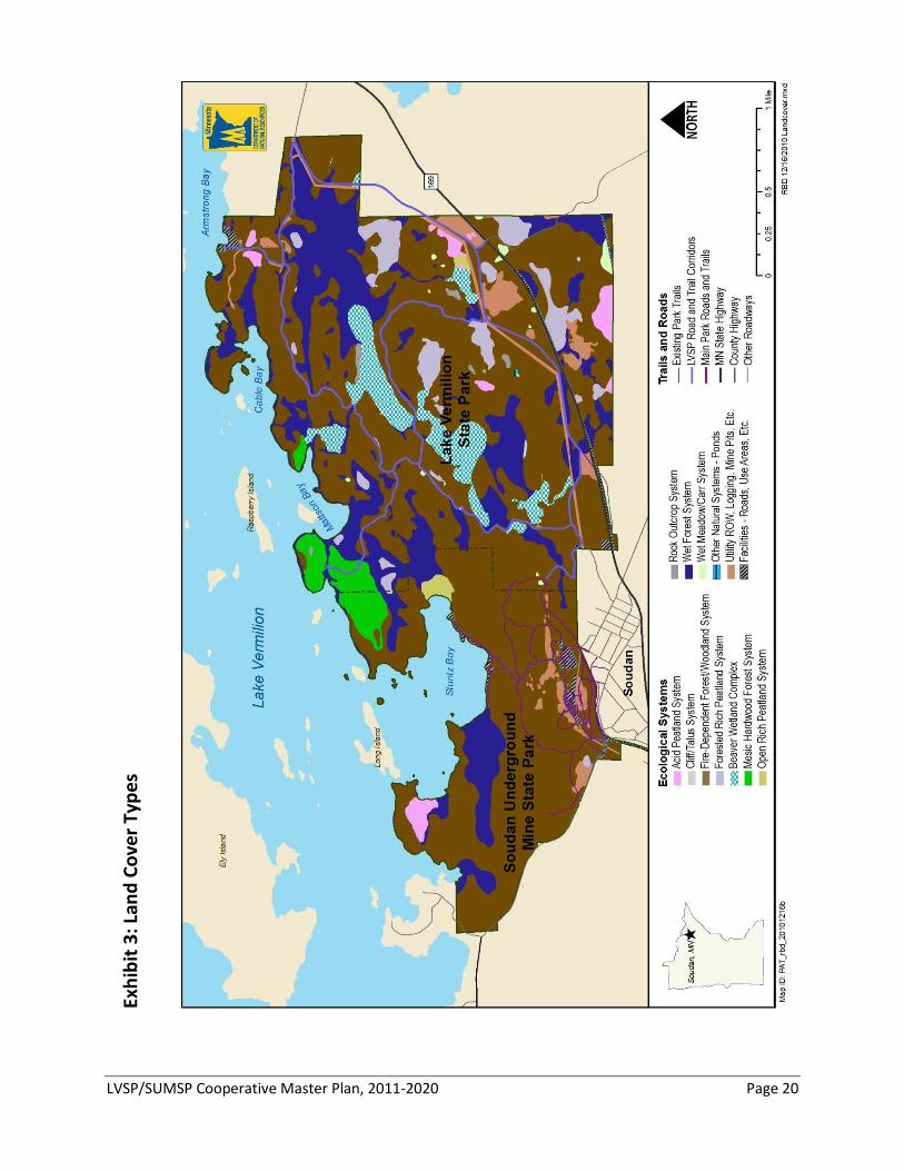
LVSP/SUMSP Cooperative Master Plan, 2011-2020 Page 20
Exhi
bit 3
: Lan
d Co
ver T
ypes
LVSP/SUMSP Cooperative Master Plan, 2011-2020 Page 21
Open woodland stands composed of pines, birch and aspen grow on
shallow, nutrient poor soils on some of the hill tops. Jack pine, red pine and northern pin oaks grow in areas with even shallower, droughtier soils. Fruiting shrubs, such as blueberries and juneberries, are abundant in these habitats. These habitats sometimes grade into open, rocky outcrops with abundant lichens and mosses. Cliff faces and talus slopes are extreme habitats where very hardy (and often less common) species occur.
Fire helped establish and maintain these habitats, but it was infrequent—
stand-replacing fires occurred every 200-250 years or so. Native peoples used fire as a tool for managing the landscape as well; they may have used it locally to maintain berry patches or keep habitation sites open.
Soudan Underground Mine State Park has a total of 342 acres of old-
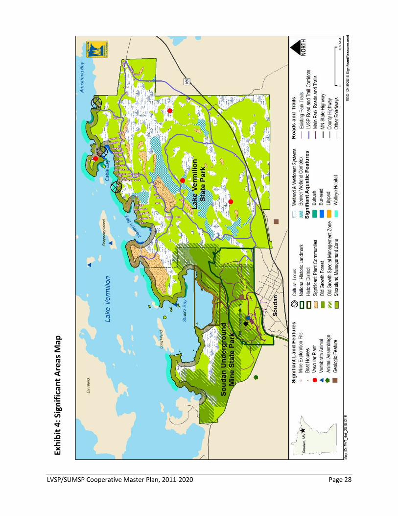
growth forest—mostly red pine. These stands were formally designated through a DNR evaluation and selection process. Selection of, and management direction for, old growth stands is set by DNR policy. Old growth forest habitats are increasingly rare in Minnesota; approximately 38,000 acres have been designated on all DNR administered lands in the state. These stands, along with policy-directed 330-foot buffers, are shown on the Significant Areas Map (pg. 28). No old growth has been designated or identified at Lake Vermilion State Park.
Field work in the summer of 2010 and a search of the DNR Natural Heritage Information System (NHIS) database located rare plants, animals, native plant communities and other rare features within the vicinity of the parks. Eight rare species of plants and animals have been documented at the parks or are known from the immediate vicinity.
Plants • Alpine woodsia (Woodsia alpina), a state special concern fern of cliff
habitats • Dragonmouth orchid (Arethusa bulbosa), a rare orchid of forested
bogs • Small water crowfoot (Ranunculus gmelini), a rare plant found at the
edges of ponds, streams and lakes Animals
• Gray wolf (Canis lupus), a federally threatened, state special concern species, known to the parks and widespread in northern Minnesota
• Canada lynx (Lynx canadensis), a federally endangered species, which is rare in northern Minnesota
• Bald eagle (Halieaetus leucocephalus), a state special concern species, which nests in the parks
• Eastern pipistrelle bat (Perimyotis subflavus), state special concern species that roosts in mine habitat and forages throughout the parks
Eight rare species have been documented in the parks or their immediate vicinity.
LVSP/SUMSP Cooperative Master Plan, 2011-2020 Page 22
• Northern myotis bat (Myotis septentrionalis), a state special concern species that roosts in mine habitat and forages throughout the parks
The workings of the Soudan Mine provide critical habitat for several
species of bat, including big brown, little brown, northern myotis and eastern pipistrelles. Upwards of 10,000 bats roost in the mine at various times of the year, but the mine stands out in importance as a winter hibernaculum—perhaps the most significant in Minnesota. Bats migrate from across the region to winter there. Open areas near water or wetlands are typical bat foraging habitats. It is unknown, but likely, that the beaver wetland complexes are important for bats as they prepare for hibernation at the mine.
Guidance for Natural Resource Management The DNR’s legislative direction for natural resources management in park
settings is to 1) manage for native species and habitats that were present at the time of European settlement; 2) preserve and perpetuate other significant natural, scenic, scientific and historic features; 3) maintain a balance of plant and animal life; and 4) re-introduce desirable species (MS 86A.05). In practice, this means working to sustain healthy native plant and animal communities into the future. This means not only keeping the on-site land and water resources healthy; it also means recognizing that the parks play an important role in maintaining the ecological health of a broader area. This goal cannot be achieved in isolation—the parks are intimately tied to their surroundings.
These guidance statements are intended to direct resource management
activities and inform development decisions over the life of the plan. In addition to the recommendations that follow, additional guidance and recommendations should be sought from Subsection Forest Resource Management Plans (SFRMP) for the Border Lakes and Nashwauk Uplands subsections, the State Wildlife Action Plan, as well as watershed-level planning efforts.
Park resource management will develop natural resource research,
monitoring and outreach programs to facilitate the adaptive management of the parks’ natural resources.
NR1.1: Develop a cooperative unit resource management plan to direct
management activities within the parks.
NR1.2: Continue and expand the natural resource inventories in the park. Native plant community mapping is quite thorough for Lake Vermilion State Park, and similar inventories should now be completed at Soudan Underground Mine State Park as well. Field surveys should also continue
The underground mine is an important bat hibernaculum.
Recommendation NR1: Develop research, monitoring and outreach programs to facilitate adaptive resource management in the parks.
LVSP/SUMSP Cooperative Master Plan, 2011-2020 Page 23
to investigate birds, mammals, reptiles, amphibians and invertebrates using both parks. NR1.3: Incorporate climate change effects into resource management planning and implementation. Park resource management will assess the likely effects of climate change on the parks’ natural resources, provide opportunities for scientists to conduct climate change research within the parks, and implement appropriate monitoring, resistance, resilience and facilitation strategies to minimize the impact of climate change on the parks. NR1.4: Continue and expand monitoring and research of bat use of the parks and develop a response plan for Soudan Underground Mine for white-nose syndrome in bats. NR1.5: Inventory significant geological features of the park, especially sulfide-bearing rocks, to avoid disturbance in the future.
NR1.6: Use interpretation and outreach to more effectively promote understanding and awareness of natural and cultural resources within the parks. These programs should also explore ways to involve a variety of people in the resource management work at the park (e.g., citizen science, habitat improvement projects).
Resource management in the parks will take actions that will protect
endangered, threatened, rare, and/or significant plant and animal species and unique geologic features.
NR2.1: Avoid known populations of rare plants and animals in park development. NR2.2: Consult the State Wildlife Action Plan to help guide habitat decisions to benefit less-common animal species. NR2.3: Conduct site-specific assessments and environmental review as development is planned. NR2.4: Maintain rare species habitat. NR2.5: Conduct a complete assessment of surficial geological features for both parks and protect areas with unique geological features (e.g., Soudan Banded Iron formations).
Recommendation NR2: Protect species in greatest conservation need and unique features.
LVSP/SUMSP Cooperative Master Plan, 2011-2020 Page 24
Resource management in the parks should maintain, enhance or restore a variety of healthy natural communities, especially uncommon forest types or components. Exhibit 4, pg. 28, identifies significant land, aquatic and cultural features within the parks.
NR3.1: Preserve the dry open woodlands with thin soils, rock outcrops, cliffs and talus slope features. These plant communities cannot sustain heavy recreational use. Avoid intensive park development in these plant communities; where impacts to these plant communities cannot be avoided, minimize through best management practices. NR3.2: Preserve the beaver wetland complexes within Lake Vermilion State Park, and provide buffers around wetlands to allow beaver to forage and flood. Park development should plan for beaver activity when siting and constructing roads and trails. NR3.3: Preserve the mesic hardwood forests. This plant community is uncommon in this part of the state and should be preserved for research and interpretation. Where impacts to this plant community cannot be avoided, care should be taken to minimize them through best management practices. NR3.4: Encourage the development and maintenance of older forests. This can be accomplished by locating park development to avoid impacts to existing old growth stands or further fragmenting old growth stands. Where-ever possible, physical development and recreational facilities should be clustered together to maximize forest patch size and reduce fragmentation. Park resource management should follow DNR old growth forest management guidelines.
NR3.5: Prevent and control the introduction, establishment and spread of terrestrial and aquatic invasive plants. The parks should implement best management practices for preventing and controlling invasive species; identify, treat and monitor existing and new invasive infestations; and follow DNR policy on invasive species.
NR3.6: Employ a variety of forest management techniques including prescribed fire, logging and non-commercial thinning or release, planting, scarification and seeding to help meet management objectives (see Appendix C).
Resource management in the parks should preserve or enhance water
resources and aquatic systems.
NR4.1: Preserve the parks’ open and forested wetlands and peatlands.
NR4.2: Maintain the integrity of the parks’ undeveloped shoreline and near-shore habitats. Locate park development to avoid impacting or fragmenting the shoreline and near-shore habitat. Shoreland protections
Recommendation NR3: Maintain, enhance or restore a variety of healthy natural communities.
Recommendation NR4: Preserve or enhance water resources and aquatic systems.
LVSP/SUMSP Cooperative Master Plan, 2011-2020 Page 25
should consider meeting or exceeding proposed Minnesota Shoreline Rules (draft 2009) for development in sensitive shoreland districts (on natural environment lakes). When development in shoreland and wetland areas is proposed, development should mitigate impacts through the use of BMPs (see “shoreland management zone,” Exbibit 4, pg. 28).
NR4.3: Employ strategies to minimize phosphorus and sediment inputs by maintaining lake and wetland buffers, collecting and treating runoff from hard surfaces and encouraging the use of biodegradable soaps and other cleaning products.
NR5.0: Carefully manage high-use areas like campgrounds, picnic areas
and heavily used trails so that natural and cultural resource degradation is minimized while visitor safety and enjoyment are enhanced. Natural and cultural resources in use areas should be appropriately protected and maintained and serve as examples of sound resource management for visitors to experience.
Park resource management should manage wildlife populations for
ecological sustainability.
NR6.1: Manage white-tailed deer populations so native vegetation and tree regeneration goals are met. The parks should annually assess the need for deer reduction and conduct and administer hunts if needed. NR6.2: Monitor other wildlife populations, and if needed, create and implement management strategies to maintain ecosystem sustainability (e.g., beaver). NR6.3: Maintain healthy bat populations at the mine.
NR7.0: Work with the Bois Forte Band of Chippewa to identify and manage traditional use harvest or collection areas within the parks, which may include sustainable harvest of traditional medicinal plants and birch bark. Develop understandings that allow these traditional collections to continue.
Recommendation NR5: Carefully manage high- use areas to prevent resource degradation.
Recommendation NR6: Manage wildlife populations for ecological sustainability.
Recommendation NR7: Identify and manage traditional use harvest or collection areas.
LVSP/SUMSP Cooperative Master Plan, 2011-2020 Page 26
Cultural Resource Management Significant efforts were made in the few months Lake Vermilion State
Park has been in state ownership to identify cultural resources present on the property and to identify the features most in need of protection and management as the parks are developed (e.g., habitation sites, medicinal plants and birch bark harvest areas). Work began with a search of relevant records and literature and meetings with the Bois Forte Band. On-site investigations began before leaf-on in the spring; miles of ground were systematically walked looking for signs of human disturbance or use. Shovel testing was performed at two sites and intensive testing was done at one of those sites. Consultations were also undertaken with the Bois Forte Tribal Historic Preservation Office and tribal elders.
Many of the cultural resources at Lake Vermilion State Park relate to
the iron ore mining that took place at Soudan Mine from the 1880s to the 1960s. The mine is listed on the National Register of Historic Places as a National Historic Landmark—the highest designation that can be given. The Statement of Significance from the National Historic Landmark nomination describes the historic importance and resource quality that raises Soudan Underground Mine State Park to National Historic Landmark status:
The oldest and deepest in the state, Soudan Mine’s opening in 1884
marked the beginning of the exploitation of one of the richest iron ore deposits in the world and the emergence of Minnesota as the leading iron-ore producing state in America. The mine remained active until 1962; a number of its original buildings survive.
The Soudan Mine National Historic Landmark includes several buildings and structures associated with the mine, including the following: • Engine House (1901) • Crusher House (1904) • Drill Shop (1917) • Machine Shop (1925) • Air Compressor Building - smokestack and foundation (1925) • Dry House (1925)
Other structures and buildings within the landmark boundary are the open mine pits, Mine Shaft #8 and Headframe, Alaska Shaft and Headframe, the Ore Trestle and Stockpile and the Mine Rescue Station. A number of cultural resources associated with the mine are known to be located outside the National Historic Landmark boundary, including the Air Compressor Building (located down on Stuntz Bay), which is listed as a contributing element in the landmark nomination.
Another historic area related to the mine is the Stuntz Bay Boathouse Historic District, which is comprised of 143 boathouses plus the compressor building and smokestack from Soudan Mine. The actual
Many of the significant cultural resources at both parks are related to the properties rich iron ore mining history.
LVSP/SUMSP Cooperative Master Plan, 2011-2020 Page 27
boathouse structures are privately owned and their condition ranges from very well maintained to those receiving little or no maintenance.
Cultural resource investigations at Lake Vermilion State Park in the summer of 2010 resulted in the discovery of more than 400 iron ore test pits dating from the 1880s. The pits are located about 50 feet apart along north-south axes, and they remain as evidence of the systematic exploration that occurred as the Vermilion Iron Range was opened to European settlement.
The 2010 field work also uncovered physical evidence of human use over the course of 7,000 or more years. The oldest site includes hearths with a projectile point and obsidian flakes indicating tool manufacture. The closest known obsidian quarry is in the Rocky Mountains, so not only does this site show habitation—it demonstrates that there was trade reaching hundreds of miles to the west. A second site is a quarry for chert, which was used to make stone tools. Human-worked chert “blanks” as well as partially worked tools were found there. Other sites point to more recent use by Ojibwe peoples, including depressions that appear to be pits used in wild rice processing and other depressions that may have been food storage pits. Archaeologists also located sites of traditional birch bark harvest.
Exhibit 4, pg. 28, illustrates the significant areas within the park—natural and cultural—that will require special protections from development and visitor use. Sites marked “cultural locus” identify the general location of sensitive cultural resources.
Guidance for Cultural Resource Management The DNR Division of Parks and Trails will strive to preserve and protect
cultural resources and traditional Ojibwe use areas within the parks’ properties. Proposed development projects will evaluate impacts to these resources, and proposed development sites will be evaluated for the presence of cultural resources as part of the site selection process. When appropriate, cultural resources and traditional Ojibwe use areas will be incorporated into the parks’ interpretation and outreach plan.
CR1.1: Develop a cooperative cultural resource management plan to
facilitate the preservation and management of cultural resources in the parks. This plan will guide the inventory, evaluation, preservation and management of the cultural resources in both parks. The parks should seek assistance from the State Historic Preservation Office, the National Park Service and the Bois Forte Band of Chippewa in the writing and review of the plan.
CR1.2: Consider the Secretary of the Interior’s Standards for the Treatment of Historical Properties with Guidelines for Preserving, Rehabilitating, Restoring and Reconstructing Historic Buildings and The Secretary of the Interior’s Standards for the Treatment of Historic
Evidence was uncovered demonstrating long- term human presence on Lake Vermilion.
Recommendation CR1: Develop a cultural resources management plan for the parks.
LVSP/SUMSP Cooperative Master Plan, 2011-2020 Page 28
Exhi
bit 4
: Sig
nific
ant A
reas
Map
LVSP/SUMSP Cooperative Master Plan, 2011-2020 Page 29
Properties with Guidelines for the Treatment of Cultural Landscapes when outlining maintenance of existing structures, construction of new facilities and resource management in the Soudan Mine National Historic Landmark and the Stuntz Bay Boathouse Historic District.
CR2.1: Identify additional information needs for cultural resources
management in the parks. Inventory, evaluation and accurate recording of location information of all the cultural resources in both parks are crucial to developing management objectives and planning for future development. Inventory and evaluation should address buildings, structures, objects, archaeological sites, cultural landscapes, underground mine features and traditional Ojibwe use areas.
CR2.2: Conduct cultural resource reviews for new development proposals and resource management activities.
CR2.3: Inventory and evaluate cultural resources and record them in the DNR Parks and Trails cultural resources geodatabase, part of the overall Geographic Information System.
CR2.4: Update the cultural resource geodatabase inventory as new information is found through additional field work, consultation with Tribal Historic Preservation Offices, informant reports, oral histories and records, and literature research.
CR2.5: Maintain the on-site archive room and records system. The archive room should meet standards for preservation of culturally significant artifacts and documents.
CR3.1: Strive to preserve the historic integrity of the underground areas
at the site. The underground drifts, tunnels, facilities and artifacts are valuable cultural resources. Maintaining the historic appearance of the underground areas is most important on Level 27—the 1960s-era appearance of the drifts, side cuts and stope along the tour route are key elements for the interpretive program.
CR3.2: Balance maintaining the historic integrity of the Soudan Mine National Historic Landmark with modernizing and making buildings and equipment efficient, safe and code compliant. Replacement or upgrading of equipment or facilities can negatively impact the historic character and appearance of the historic mine. Lighting, electrical systems and other mechanical operations need to be efficient while still maintaining the historic integrity of the site.
CR3.3: Evaluate park areas for vegetation removal to maintain the mine site’s industrial characteristics.
Recommendation CR2: Conduct further cultural resource investigations and develop information and archive management systems for the parks’ resources.
Recommendation CR3: Strive to preserve the historic integrity of mining operations on the site.
LVSP/SUMSP Cooperative Master Plan, 2011-2020 Page 30
CR4.1: Investigate revising the Soudan Mine National Historic Landmark nomination and boundary. There is a question as to the exact boundary of the landmark and this ambiguity must be resolved to ensure proper management of the landmark resources. Some historic features are known to be outside of the boundary. Newly discovered mining features in Lake Vermilion State Park (exploratory pits and drill holes) have not been assessed for their significance.
CR4.2: Develop a site management plan for the Stuntz Bay Boathouse
Historic District in collaboration with the Stuntz Bay boathouse lease holders and/or the Stuntz Bay Boathouse Association. The plan should balance preservation of the historic district with the DNR’s natural resources and recreational goals for the parks.
CR5.1: Follow the Division of Parks and Trails’ Collections Policy protocol (which as of this writing, is still in draft form), which sets guidelines for acquiring artifacts and accepting donations. The parks should inform local communities, mining companies and equipment distributors of the policy.
CR5.2: Integrate results of cultural resource investigations into interpretive programming. Some cultural resources are culturally sensitive and may not lend themselves to public interpretation, such as cemeteries, traditional use areas and fragile archaeological sites.
CR5.3: Work with the Bois Forte Band of Chippewa and local
communities to promote the protection and interpretation of cultural resources outside of the park boundaries. For all cultural resources related to American Indian history, the parks should partner with the Bois Forte Band of Chippewa.
CR5.4: Explore potential cooperative preservation projects with Iron
Range Resources and local communities for conserving and interpreting mining history and facilities (e.g., office buildings, employee housing and other structures still standing).
Recommendation CR4: Develop and/or review site management protocols for historic places.
Recommendation CR5: Incorporate cultural resources into the parks’ interpretation and outreach efforts.
LVSP/SUMSP Cooperative Master Plan, 2011-2020 Page 31
INTERPRETATION AND OUTREACH Existing Interpretive Services Only recently established at the writing of this Master Plan (2010), Lake
Vermilion State Park does not offer any interpretive programs.
The Soudan Mine interpretive operation is one of only a few in the state that is tour-based. The primary feature is a 90-minute tour that includes a ride 2,341 feet underground via a "cage" and a rail car to the last active workings of the mine. The tour emphasizes historic mining techniques and what work was like for a miner. Public tours are currently offered daily from Memorial Day through September and on weekends in October. Group tours are available year round. About 5,000 of the 30,000 people who take tours each year are members of organized groups (e.g., schools, scouts).
Above-ground visitors can learn about the dry house, drill shop, crusher
house and engine house through interpretive displays, as well as a self-guided audio tour. A virtual video tour of the underground experience is available to those unwilling or unable to go underground.
Soudan Underground Mine State Park also offers tours of the high-energy physics lab in cooperation with the University of Minnesota. These tours are offered during the same dates as the mine tours. Other special programs are occasionally offered on topics such as bats, geocaching or local history. The park has piloted a videoconference program with schools to provide a connection between distant classrooms and the mine. The park has also collaborated with local schools and the physics lab with science education opportunities.
Soudan Underground Mine State Park operates one of the most technically and operationally challenging tours in the state. In addition to skilled mine hoist operators, trained staff is required to lead each tour. During the summer season, the Soudan operation has a number of part-time and intermittent interpreters on staff. A core group of intermittent interpreters is maintained during the off season to help with group tours. At current staffing patterns and levels, there is not capacity to offer non-tour programming during the summer.
Proposed Interpretive Services The two parks will share interpretive resources and offer an integrated
interpretive services program within the parks. Visitation to Lake Vermilion State Park is expected to boost underground mine tour participation at Soudan Underground Mine State Park, and conversely, Lake Vermilion State Park will also offer additional opportunities for those coming for tours of the underground mine. As is standard operating procedure, a parks’ interpretive plan will be written to implement the proposed interpretive directions discussed here (See recommendation
Soudan Underground Mine State Park operates a tour-based interpretive program that is one of the most operationally and technically challenging in the state.
LVSP/SUMSP Cooperative Master Plan, 2011-2020 Page 32
“IS5”). In this case, the interpretive plan will integrate interpretation across two parks and be guided by the core notion that interpretation should accomplish three principal things: 1) cause people to transform their lives, 2) make the subject matter meaningful within the context of their own lives; and 3) empower them to take action.
IS1.1: Target less-experienced outdoor users as the primary audience for
non-mining-related interpretation at the parks. The existing underground mine tours (and the audiences they currently attract) will remain the primary focus of the underground mine interpretive program. Because the underground mine tours already attract many school groups as a primary audience, an important subset of this primary audience group will include schools and other youth groups/ organizations.
IS1.2: Target family groups, baby boomers and regional day users as
secondary audiences of interpretive services for both of the parks. Regional day users include Lake Vermilion-area residents that are permanent, seasonal and temporary (e.g., resort guests).
The parks offer an opportunity to interpret a wide variety of thematic
areas. Regardless of what themes are chosen, they should encourage visitors to think creatively and critically and to use their imagination. The broad themes that fit best with the primary audience (inexperienced outdoor users)—while still appealing to the secondary audiences (families, baby boomers and day users)—include the following:
IS2.1: Creating a sense of place and comfort in our natural environment. This interpretive theme will be accomplished by teaching outdoor skills, such as camping, paddling, geocaching, building campfires, fishing, archery, snowshoeing—skills that will enable individuals to better enjoy outdoor recreational experiences.
IS2.2: Crossing boundaries.
This theme will explore how the parks relate to other areas, regions, biomes and nations. It will include a focus on cultural history (e.g., mining and exploration, logging, railroads, American Indians, fur trading, current resource management) and natural history (e.g., geology, flora and fauna—especially the northern forest habitat).
IS2.3: Scientific discovery. A wide range of scientific inquiry is already occurring within the parks—
water quality testing, aquatic vegetation mapping, physics experiments, bacteria research and bat research—all of which have interpretive possibilities. There are also opportunities for citizen science projects in these and other areas of inquiry.
Recommendation IS1: Target less-experienced outdoor user groups, as well as families, baby-boomers and regional day users.
Recommendation IS2: Focus on three broad themes.
LVSP/SUMSP Cooperative Master Plan, 2011-2020 Page 33
IS3.1: Continue to offer guided tours as a cornerstone feature of the interpretive offerings at the parks. However, seek out emerging technologies and collaboration between the two parks and local communities to push interpretive tour offerings in exciting new directions.
IS3.2: Use a variety of interpretive approaches targeted to intended audiences and messages: • Visitor center displays, touch screens, kiosks and signs • Personal interpretation and skill development • Increased use of technology, such as audio tours, smart phones,
social networking and interactive Web-based programming
IS3.3: Conduct personal (staff-led) programming at a variety of locations within the parks—including the mine site, visitor centers, trail centers, campgrounds and access points—as well as adjacent areas off-site (e.g., on the lake, at Jasper Peak and Bear Island State Forest, along nearby trails, at community centers/events).
IS3.4: Provide focused interpretation of the lake as a natural and cultural resource. Consider offering or contracting guided boat tours on the lake to allow visitors to view the park from the lake and provide opportunities to view associated natural and cultural features, such as waterfowl, water quality, fish and shoreline habitat, shorebird colonies, cultural resource sites (where appropriate) and the Stuntz Bay Boat House Historic District.
IS4.1: Model how state parks should partner with others. Partners might serve as program and activity advisors or as interpretive resources. Partners could also deliver interpretive services.
IS4.2: Explore potential partnerships, including the following: • Bois Forte Band of Chippewa • Local community—including the local charter school, resorts, local
government entities, community and conservation organizations and their members, sporting goods suppliers, mining companies and professionals in the field
• Schools and school districts—regional and across the state • Various nonprofit and state organizations, including area colleges/
universities, historical societies, MN Master Naturalists • Other DNR divisions, including opportunities with the Division of
Forestry, such as the Jasper Peak fire tower • Local experts, such as fishing or canoe/kayak guides
IS4.3: Explore new outreach opportunities to schools, such as
videoconference technologies, which allow a park interpreter to deliver programming to classrooms without travel. This programming should be focused on content areas unique to these parks and should act to support and encourage follow-up visits to the parks.
Recommendation IS3: Incorporate a variety of interpretive approaches and locations.
Recommendation IS4: Model how to partner with others.
LVSP/SUMSP Cooperative Master Plan, 2011-2020 Page 34
IS5.1: Conduct additional planning before new interpretation and
outreach opportunities are implemented. A standard tool DNR uses for organizing this sort of information and thinking is the Park Unit Interpretive Plan (PUIP). The PUIP gathers background information on the specific audiences and stories that are best served by the parks’ location and resources. The PUIP outlines specific themes and the methods that could be used to deliver messages.
IS5.2: Explore opportunities to share interpretive services among nearby sites, if additional staff and funding resources become available. Consideration not only needs to be given to services provided at Lake Vermilion and Soudan Underground Mine state parks, but also at nearby Bear Head Lake State Park, Bear Island State Forest and other DNR facilities.
IS5.3: Make outreach an explicit focus of the PUIP. The Lake Vermilion/Soudan Underground Mine PUIP should identify specific groups that could be served by the parks and potential partners who could help connect the parks with new users. Particular attention should be given to reaching out to minority groups, émigré’ communities and others less-experienced with the outdoors.
IS5.4: Develop the PUIP in close collaboration with facilities development plans for the parks, as interpretive services programs will have specific facilities needs to be well implemented (see also specific development recommendations related to this, VS5.1). Some needs that are already anticipated, include the following: • Improved underground mine tour and interpretive space that better
accommodates tour groups (e.g., schools)—more-efficient tour staging, multi-purpose learning/lunching area and theater
• Outdoor pavilions and/or amphitheaters for programs • Spaces for outdoor-recreation gear rental and storage • Larger and improved archival space, with an approved heating/
cooling system to help preserve the underground mine archival collection.
Recommendation IS5: Write a park unit interpretive plan to operationalize the ideas discussed here.
LVSP/SUMSP Cooperative Master Plan, 2011-2020 Page 35
RECREATIONAL USE AND VISITOR SERVICES
Existing Facilities and Park Uses Lake Vermilion State Park does not currently have any permanent
facilities on the property. U.S. Steel Corporation removed three leased cabins—and their associated water, electric and individual sewage treatment systems—from the property as it prepared the site for a residential development. The Minnesota DNR created a small, temporary, boat-up, day-use area on one of the former lease lot sites for the summer of 2010, which included a portable toilet, picnic tables and a fire ring. The area experienced steady use throughout the summer.
The Lake Vermilion State Park property has a myriad of former logging
and skid trails throughout, the result of active timber management on the property by its previous owner. U.S. Steel cleared some of those trails for roads to access its proposed residential development in the fall of 2009, and DNR staff and Conservation Corps of Minnesota (CCM) crews have brushed some of the major access trails for resource assessment and temporary recreational use corridors (e.g., deer hunting and a groom-able snowmobile trail). Old State Highway 169 (the “Old Ely Road”) was abandoned when the highway was realigned in the 1960s, but the corridor and road-bed are intact and run through the southern one-third of the property, along with an above-ground power line. The corridor is still used to access private property along Armstrong Bay, at the northeastern corner of the park property. U.S. Steel posted the land as private property (“no trespass”) and constructed berms along trail access points within the past decade, significantly curbing or ending previous local use on the property, such as trapping, hiking, hunting, ATV riding, snowmobiling and cross-country skiing.
Soudan Underground Mine State Park has a mix of visitor use and
recreation facilities in the historic mine area and central portion of the park. Facilities are concentrated in two areas, the No. 8 Shaft Complex (shaft headframe, the Dry House and other associated historic structures) and the Maintenance Complex (park office, equipment storage and workshops and the park manager’s residence). The No. 8 Shaft Complex supports the majority of visits to the park, where the Dry House serves as the current visitor center. This area also features the interpretive tour and exhibit area, visitor and staff parking, and a picnic area. The Maintenance Complex serves as the operational and maintenance area for the park and is also located within the designated National Historic Landmark area.
The trail system in Soudan Underground Mine State Park is limited to the
historic mine area and central portion of the park. There are currently no trails to the western or northeastern sections of the park, although historically hiking occurred in that area. Current uses on the central, maintained trails include warm- and cold-season hiking, snowshoeing
Lake Vermilion State Park has no current development; travel corridors follow historic logging activities on the property.
Soudan Underground Mine State Park’s visitor use and trails are located in the central part of the property, close to the historic mining area.
LVSP/SUMSP Cooperative Master Plan, 2011-2020 Page 36
and snowmobiling. The Mesabi Trail, which is paved for bicyclists and other non-motorized recreation, currently edges along the southern boundary of the park. The Taconite State Trail runs south of the park boundary and is a natural-surfaced, multiple-use trail that is designated for snowmobiles.
The Lake Vermilion shoreline remains in a natural state throughout most of both parks’ properties. Previous development and disturbance has occurred at the former U.S. Steel cabin lease lots (approximately 900 linear feet), a small boat-up, day-use area maintained by the Lake Vermilion Sportsmen’s Club on Swedetown Bay (less than 50 linear feet), and the Stuntz Bay boathouse area (approximately 3,600 linear feet). Shoreline uses currently include picnicking, boat access via a small Stuntz Bay Association leased boat ramp, and houseboat tie ups on a few of Soudan Underground Mine State Park’s islands.
There are currently no camping opportunities in either of the parks, limiting park visitors to day use. Other campground and resort facilities exist nearby, including Hoodoo Point, McKinley Park, Bear Head Lake State Park, McCarthy Beach State Park, Kabetogama State Forest campsites on Hinsdale Island, and sites within Superior National Forest and the Boundary Waters Canoe Area Wilderness.
Development and Management Concerns Soudan Underground Mine State Park is home to two important historic
features: 1) the underground mine and its associated buildings are designated as a National Historic Landmark; and 2) the Stuntz Bay boathouse area is a designated historic district. The sites provide valuable opportunities to connect Minnesota’s mining history and culture with current and future generations of parks and trails users and must be carefully managed for that purpose. Development in or changes to these areas will require careful evaluation of the impacts to these historic areas, as well as consultation with the Minnesota Historical Society’s State Historic Preservation Office.
In addition, the boathouse area provides a unique challenge for park
management, as there are currently 143 active boathouse leases to be managed on the site. In 2001, the Minnesota State Legislature extended all of the leases to the lifetime of the lessee (irrespective of the current lease or the previously set expiration of 2015) and made allowances for one transfer to a relative within three degrees of kindred according to civil law, or to first cousins. The lease extensions have created an ongoing administrative burden to Soudan Underground Mine State Park and are in conflict with overarching DNR goals of providing public access and minimizing impacts to riparian and near-shore habitat.
Areas of cultural and historical significance will require continued protection.
LVSP/SUMSP Cooperative Master Plan, 2011-2020 Page 37
Archaeological field work at Lake Vermilion State Park in 2010 identified three sites of cultural interest and several hundred mining test pits along north-south transects adjacent to the shoreline. These cultural areas will require protection. Standard protocol is that additional archaeological investigation is conducted as facility locations are considered and as roads, trails and park facilities are constructed. Additional archaeological investigation should occur along the shoreline of Soudan Underground Mine State Park as well.
Impacts to wetlands and water quality will need to be avoided,
minimized or mitigated during park development. Much of the parks’ property is situated on shallow soils over bedrock. Because the rock contains sulfides, care will need to be taken to minimize the impacts from rock blasting during development (sulfide-bearing rock can create sulfuric acid in rainwater runoff). Facility locations will also need to be situated to minimize impacts to wetlands, which cover nearly 30% of the parks’ land area.
In addition, water that is currently pumped (60 gal/min) from the
underground mine requires treatment for copper and cobalt, as levels currently exceed state water quality standards. Pumping water from the mine is necessary to facilitate protection of the underground historical site, to continue underground scientific research and to allow for visitor tours. Future development will need to accommodate continued water treatment from this pumping activity.
The park contains several sensitive native plant community types and is
home to rare plant and animal species. Soudan Underground Mine State Park also has 342 acres of old-growth forest. The undeveloped shoreline along both parks provides critical aquatic habitat for a variety of game and non-game fish and wildlife species. The DNR will need to balance the development of facilities and recreational opportunities with its goal of avoiding or minimizing fragmentation of these high-quality habitat areas (aquatic and terrestrial) and protecting the parks’ habitats that sustain healthy populations of rare species. Several terrestrial invasive species were identified within the parks, and care will need to be taken to prevent the spread of existing occurrences and to prevent the introduction of additional invasive species during development and construction processes.
Proposed Recreational Uses Lake Vermilion and Soudan Underground Mine state parks provide
opportunities for multiple kinds of recreational activities within the parks. Early public and Citizens Advisory Committee (CAC) input indicated that the most desired types of recreation at the park are hiking, biking and snowmobiling. Lake-based recreation will clearly be a draw to the parks as well, including fishing, swimming, paddle sports (canoe/kayak), boating and shoreline picnicking on Lake Vermilion. Opportunities exist to cross-develop warm- and cold-season trail opportunities: aligning
Impacts to wetlands and water quality need to be avoided, minimized or mitigated.
Development will have to avoid or minimize impacts to and fragmentation of native vegetation.
LVSP/SUMSP Cooperative Master Plan, 2011-2020 Page 38
warm-season hiking trails with snowshoe and cross-country ski opportunities; natural-surface bike trails with snowmobiling. The DNR also seeks to provide new, high-energy outdoor recreational and skill- building opportunities at these parks to encourage visitation from younger age demographics.
Connections to the adjacent Mesabi and Taconite trails will help
encourage development of these parks as all-season, northern Minnesota destinations for multiple kinds of trail use. There is also ample opportunity for connections to warm-season motorized recreation given the proximity of the Bear Island State Forest.
RU1.1: Develop a plan for a cooperative road and trails system for both
parks that outlines where road and trail alignments will be located, what kinds of use will be permitted on trails, and how best management practices will be used to construct, maintain and manage the trails. The trail system plan will encourage use of trails as an alternative to vehicle use. The plan will identify potential travel-related environmental concerns and ways to avoid or mitigate them.
RU1.2: Focus primarily on developing the following kinds of trails within
the parks: 1) Hiking 2) Biking (touring and mountain) 3) Snowshoeing 4) Cross-country skiing (traditional and skate) 5) Snowmobiling
RU1.3: Provide the Mesabi Trail with an alignment through the parks
along the abandoned corridor of Highway 169 (Old Ely Road). RU1.4: Work with the North Country National Scenic Trail (NCST) to
determine if a trail alignment through the parks is appropriate. If so, the parks should work with NCST to locate an appropriate alignment for a narrow, single-track trail route.
RU1.5: Develop recreational trails in the park according to the DNR Trail
Planning, Design and Development Guidelines. The trails should be cross-developed for warm- and cold-season uses whenever appropriate, maximize sustainability, and minimize habitat fragmentation.
RU1.6: Develop one core, multiple-use trail backbone through the central
wetland complexes, with looping trails for a variety of recreation types connecting to that backbone (e.g., hiking/snowshoeing, biking/skiing, snowmobiling). This will limit disturbance of the wetland complexes and provide a low-difficulty route through the central part of the park.
Recommendation RU1: Develop warm- and cold-season trails opportunities within the parks.
LVSP/SUMSP Cooperative Master Plan, 2011-2020 Page 39
RU2.1: Seek to provide connections for snowmobiles to the adjacent Taconite and Arrowhead state trails and local grant-in-aid land and ice trails. This will encourage trails users to base multiple-day visits to the area from the parks.
RU2.2: Encourage development of and connections to water trails.
Consideration should be given to developing a water trail on Lake Vermilion, with connections to clustered shoreline campsites in the parks and on other public lands on the lake. The parks should also cross-promote other local water trails in the area, in particular the Vermilion River and Little Fork River trails.
RU2.3: Work with DNR Forestry, St. Louis County and local off-highway
vehicle (OHV) clubs to create trail connections between the Lake Vermilion State Park trails campground (VS4.2) and the Bear Island State Forest, where 95-plus miles of OHV riding opportunities exist. Access to the Bear Island State Forest is about 1.6 miles southeast of the park boundary along the Murray Forest Road.
RU2.4: Partner with local equipment and service providers to connect
visitors with local fishing, hunting, birding, paddling and other guides and equipment rentals. The parks should explore possible partnerships and/or service contracts to provide within-park rental services. The parks should develop clear guidance on when contracting for these kinds of services is appropriate, utilizing any best practices information available from other state and federal parks operations.
RU3.1: Provide outdoor recreational skill areas and facilities to support
skill-based interpretive programs. Park development should be purposefully designed and built to support outdoor recreational skill-building opportunities (e.g., orienteering, archery, camping, biking/hiking skills).
RU3.2: Conduct market research with target market demographics
(youth, young adults and young families) to determine which kinds of recreational opportunities they are seeking in adventure areas of the park.
RU3.3: Support inexperienced parks and trails users with onsite activities
and services that include equipment rental, skill-building programs and guided activities (see RU2.4).
RU3.4: Encourage less-experienced parks and trails users to participate
by providing for a variety of experience levels in camping and trails—from highly organized settings to semi-primitive; from easy, low-grade touring trails to higher-difficulty, skill-building hiking, biking and archery trails.
Recommendation RU2: Facilitate connections between the parks and other area outdoor recreational opportunities.
Recommendation RU3: Develop programs and activities to encourage outdoor recreational participation amongst next-generation users.
LVSP/SUMSP Cooperative Master Plan, 2011-2020 Page 40
Proposed Development of Visitor Services Visitor amenities at Lake Vermilion and Soudan Underground Mine state
parks will be developed with high standards for sustainability, conservation design and utility. Public input indicated a desire for lake-oriented recreational connections and protection of the “up-north” aesthetics of the Lake Vermilion area. Day-use opportunities most desired include a visitor center with interpretive exhibits; picnic and outdoor gathering areas; fishing and swimming areas; outdoor recreational trails with scenic overlooks and lake views; and outdoor recreational opportunities for youth and young families.
A mix of overnight accommodations is desired—from semi-primitive and
remote camping opportunities, to organized campgrounds, group camps and camper cabins/yurts. Making these parks a year-round destination will require the DNR to winterize some of the facilities and operations. The DNR will also work with local resorts and businesses to cross-promote park recreational opportunities and overnight options with those offered through private providers. The DNR will also develop camping facilities and related activities using shoreland best management practices (e.g., appropriate setbacks, native vegetative buffers), which will also serve to minimize undesirable impacts to the parks’ residential neighbors, particularly with respect to noise.
Exhibit 5, pg. 41, illustrates some preliminary recommendations for
park development areas, which are based on recommendations from the Citizens Advisory Committee and early public input. Site considerations may necessitate alternative siting of facilities as further investigations of ecological impacts and site suitability are conducted.
VS1.1: Model sustainability and conservation design. Water, sewer,
utilities and other infrastructure should be designed in a sustainable manner and situated in such a way that they have the least impact on the parks’ natural and cultural resources. Development should embrace best management practices for shoreland management—avoiding, minimizing and mitigating impacts within the Vermilion River watershed.
VS1.2: Protect Lake Vermilion’s scenic and aesthetic qualities during
facilities planning and development. This can be accomplished by siting much of the new development in areas where the viewshed from the lake is least impacted and by using design elements that blend well with the landscape. The parks should also design boardwalks and overlooks to minimize their visual impact when seen from Lake Vermilion and other vantage points. One viewshed to be protected that was identified during the planning process was that from the peak overlooking Mattson Bay (see Exhibit 5).
Recommendation VS1: Model conservation design and sustainable development principles.
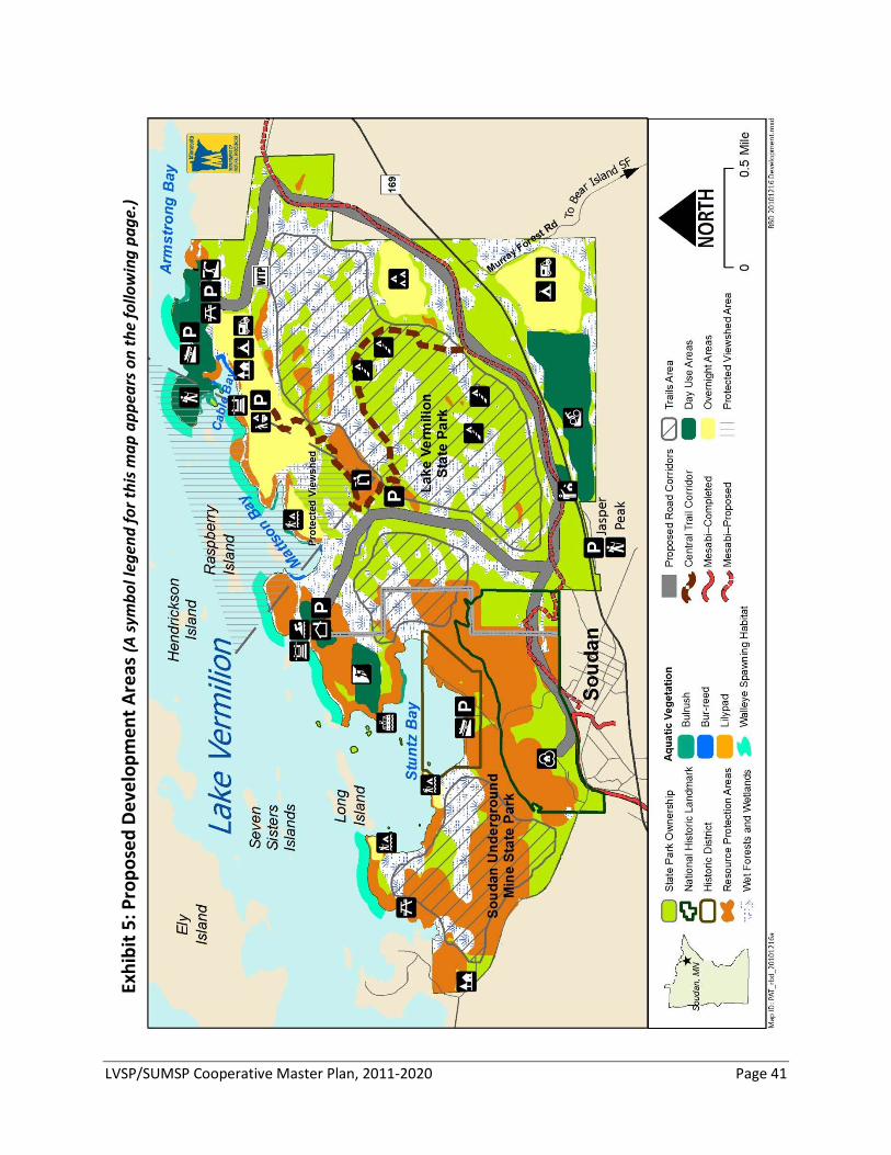
LVSP/SUMSP Cooperative Master Plan, 2011-2020 Page 41
Exhi
bit 5
: Pro
pose
d De
velo
pmen
t Are
as (A
sym
bol l
egen
d fo
r thi
s map
app
ears
on
the
follo
win
g pa
ge.)
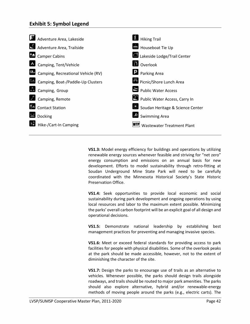
LVSP/SUMSP Cooperative Master Plan, 2011-2020 Page 42
Exhibit 5: Symbol Legend
½ Adventure Area, Lakeside
t Adventure Area, Trailside
Q Camper Cabins
! Camping, Tent/Vehicle
, Camping, Recreational Vehicle (RV)
/ Camping, Boat-/Paddle-Up Clusters
% Camping, Group
‐ Camping, Remote
¥ Contact Station
^ Docking
" Hike-/Cart-In Camping
r Hiking Trail
H Houseboat Tie Up
T Lakeside Lodge/Trail Center
A Overlook
m Parking Area
> Picnic/Shore Lunch Area
[ Public Water Access
\ Public Water Access, Carry In
9 Soudan Heritage & Science Center
¶ Swimming Area
Q Wastewater Treatment Plant
VS1.3: Model energy efficiency for buildings and operations by utilizing
renewable energy sources whenever feasible and striving for “net zero” energy consumption and emissions on an annual basis for new development. Efforts to model sustainability through retro-fitting at Soudan Underground Mine State Park will need to be carefully coordinated with the Minnesota Historical Society’s State Historic Preservation Office.
VS1.4: Seek opportunities to provide local economic and social
sustainability during park development and ongoing operations by using local resources and labor to the maximum extent possible. Minimizing the parks’ overall carbon footprint will be an explicit goal of all design and operational decisions.
VS1.5: Demonstrate national leadership by establishing best
management practices for preventing and managing invasive species. VS1.6: Meet or exceed federal standards for providing access to park
facilities for people with physical disabilities. Some of the overlook peaks at the park should be made accessible, however, not to the extent of diminishing the character of the site.
VS1.7: Design the parks to encourage use of trails as an alternative to
vehicles. Whenever possible, the parks should design trails alongside roadways, and trails should be routed to major park amenities. The parks should also explore alternative, hybrid and/or renewable-energy methods of moving people around the parks (e.g., electric carts). The
LVSP/SUMSP Cooperative Master Plan, 2011-2020 Page 43
parks should continually explore emerging technologies for energy-efficient transportation to and within the parks.
VS1.8: Continually evaluate how creating public-private partnerships for
trail maintenance, interpretive programming, rental/service concessions and other services might contribute to local sustainable economic development opportunities for the communities of Tower and Soudan. Toward that end, the purchase agreement with US Steel allows use of up to 60 acres of the park for private provision of parks-related services. The parks should develop clear guidance on when contracting of services is appropriate, utilizing any best practices information available from other state and federal parks operations. Local businesses should be consulted in the design of retail and service spaces within parks’ facilities.
VS2.1: Give primary consideration to the Jasper Peak intersection for the main park entrance. If this location is not feasible, the Murray Forest Road location should be considered as the first alternative. The Jasper Peak area provides the most connectivity with the communities of Tower and Soudan. The parks should work with the DNR Division of Forestry to connect the Jasper Peak fire tower and overlook to the park through trails, interpretive programs and possibly remote camping opportunities.
VS2.2: Build a contact station at the main park entrance on State Highway 169 to serve as a one-stop-shop for orienting visitors to the parks and associated recreational opportunities. The contact station should include 1) registration station, 2) invasive species inspection and cleaning area, 3) general area/park information, 4) park office (for Soudan and Vermilion) and 5) public restrooms.
VS2.3: Make a road connection between Lake Vermilion and Soudan
Underground Mine state parks stemming from the main parks’ entrance across from Jasper Peak. This will relocate the main entrance to Soudan Underground Mine State Park and minimize impacts to neighborhoods in the town of Soudan.
VS2.4: Investigate the possibility of a tunnel access under State Highway
169 to the southern Lake Vermilion State Park unit. This would facilitate safe and easy access to Jasper Peak, the trails campground and the adventure area south of State Highway 169.
VS2.5: The preferred option for a main park road is a paved wishbone
alignment, with a natural surfaced, accessible trail connecting east and west sides. Paving the east-west connector trail should be evaluated in the future. A natural-surfaced recreational trail should also provide access up through the wetland complexes in the core of Lake Vermilion State Park (see Exhibit 5, pg. 41).
Recommendation VS2: Connect the parks with nearby recreational opportunities and communities.
LVSP/SUMSP Cooperative Master Plan, 2011-2020 Page 44
VS2.6: Connect the parks to the recreational trails in the vicinity. The parks should work with St. Louis County, the DNR Division of Forestry and local trails groups to ensure a safe and sustainable route for OHV travel from the trails campground into the Bear Island State Forest and to Tower/Soudan via the Taconite Trail.
VS2.7: Provide wireless connectivity in major activity centers of the parks,
including the main campgrounds and visitor center. The parks should embrace emerging technologies that make “being away” easier and enhance user experiences, but also attempt to minimize technological intrusions for those who prefer an “unplugged” experience.
VS2.8: Consider using self-service amenities whenever practical to create
operational efficiencies (e.g., registration kiosks).
VS3.1: Develop lake-oriented day-use areas and facilities at the main visitor center location, the Stuntz Bay Boathouse Historic District and Armstrong Bay.
VS3.2: Build the park lakeside lodge/visitor center near the lake,
preferably near the statutory boundary that separates the two parks. The center should be a blend of modern and up-north design (combining steel, timber and site-specific rock materials), and should include the following: 1) indoor and outdoor gathering spaces (amphitheater, lakeside deck
and indoor-/outdoor-fireplaces) 2) interpretive spaces (focused on major interpretive themes) 3) food and refreshment areas 4) retail areas (for gift shop, outfitting services, equipment rentals and
other services) 5) indoor classroom(s), meeting spaces and large informal gathering
spaces 6) staff area 7) an event center and catering kitchen.
VS3.3: Develop the area surrounding the lakeside lodge/visitor center for
day use activities including boat-up access (i.e., dockage) to the visitor center, a swimming area, shore fishing opportunities, lakeside hiking areas and an adventure area.
VS3.4: Build a public water access as part of the Stuntz Bay site
management plan (see also CR4.2). The parks will work cooperatively with the Stuntz Bay Boathouse Association to effectively administer the boathouse leases; to improve facilities for sanitation and interpretation; to address traffic, parking, lake access and other site-related concerns; and to protect the aquatic and terrestrial natural resources in the boathouse area. Park staff will continue to work closely with the Stuntz Bay Boathouse Association as the representative of the boathouse owners.
Recommendation VS3: Provide opportunities for rich, lake-based experiences.
LVSP/SUMSP Cooperative Master Plan, 2011-2020 Page 45
VS3.5: Develop a day-use area in the western part of Armstrong Bay.
Interim day use activities were available at this location starting in 2010. This area should include day-use facilities that focus on accommodating the needs of campground visitors, but would be separated from the campgrounds to provide access to day users as well. Development of this area should avoid impacts to the cultural sites and consider including the following amenities: 1) a carry-in access site and parking area for paddling sports 2) a campground boat access and parking area 3) shore-fishing opportunities 4) lakeside hiking trails 5) picnicking opportunities
VS3.6: Partner with the DNR Section of Fisheries and waterways
specialists to identify several locations for fishing piers within the parks. The piers should be designed and built in areas that maximize opportunities for catching fish, educating new entrants to the sport and providing access for people of all abilities, while at the same time minimizing impacts to critical habitat.
VS3.7: Explore the possibility of providing designated boat tie-ups, picnic
tables and fire rings on shoreline areas or island properties within the park boundaries. Criteria for selecting such sites should be established to minimize resource impacts and mixed-use recreational conflicts. Work with the lake association to provide additional shore lunch sites and possibly houseboat overnight locations.
VS4.1: Develop a clustered, family-friendly, semi-modern (i.e., electric,
sanitation, wireless capability and showers) campground within a reasonable walking distance of the lake on Cable Bay, but screen visibility of the camping from the lake. The campground should cluster like kinds of use in order to minimize user conflicts. The campgrounds should include sites for tents, camper trailers, recreational vehicle campers, camper cabins, cart-in/hike-in tents and kids’ activity areas (e.g., natural play areas). Boat docking for campers should be provided in Cable Bay and should be clustered to minimize impacts to the shoreline and aquatic habitat. Trails should connect the campground area to the Armstrong Bay hiking trails. The parks should investigate the demand for year-round use of the campground.
VS4.2: Develop a trail-oriented, semi-modern campground south of State
Highway 169, within a short distance of major recreational trails in the park and its immediate vicinity. The campground should accommodate OHV recreationalists by allowing OHV travel within the campground, providing ample trailer parking and connections to OHV trail opportunities outside the park. The campground facility should include a multi-purpose room for classes and gatherings. Attention should be given in the parks’ trail system plan to insure connectivity to park trail
Recommendation VS4: Provide a variety of overnight-stay experiences.
LVSP/SUMSP Cooperative Master Plan, 2011-2020 Page 46
opportunities for authorized trail uses and consider alternative transportation to other park facilities (e.g., electric carts). The parks should investigate the demand for year-round use of the trails campground.
VS4.3: Provide overnight opportunities for group camping. In addition to
providing group-oriented, single-site “pods” within the organized campgrounds that allow groups to be together, a designated group camp should be sited near the main park road overlooking the open-water wetland and streams area along the eastern boundary of the park. The group camp should include access to its own seasonal sanitation building to encourage use by groups with little previous camping experience (e.g., scouting groups). Connections to the core trail corridor should be made from this group-camp area. See Exhibit 5, pg. 41).
VS4.4: Offer camper cabins and work with the local resort association to insure that the park overnight opportunities are complementary with experiences offered by resorts. Camper cabins should be provided in each of the organized campgrounds (4-6 at each site) and a partnership should be explored with Breitung Township’s McKinley Park to provide some (4-6) camper cabins in that area as well.
VS4.5: Offer some primitive camping opportunities (e.g., remote, boat-
up or hike-in opportunities) as part of the range of camping options at the park. The parks should explore provision of remote yurts along the core hiking trail within the park, as well as along the shoreline for paddle-/boat-in use. The park should also provide a few clusters of paddle-/boat-up campsites. Each cluster of lakeside sites should have a well for drinking water, a vault toilet and clustered dockage. The sites, however, should be spaced to provide a remote experience. These sites would also serve a Lake Vermilion water trail, if designated.
VS5.1: Develop a “Soudan Heritage and Science Center” at the No. 8 Shaft
Complex to better accommodate and improve underground tour operations and mining interpretation (see also IS5.4). The center would focus on tour orientation (i.e., interpretive exhibits, theater and tour orientation space) and provide spaces for 1) education and tour lunch breaks (multi-purpose room), 2) tours-related interpretive staff, 3) mining-related archives and 4) a small gift shop for tour-related items. Development of the Heritage Center would allow for restoration and further interpretation of the Dry House, which is now used for tour logistics, a staff area and gift shop.
VS5.2: Create “adventure areas” to encourage outdoor recreation skills
building and participation from younger demographics. The intent is not to construct an artificial setting, but to provide places for active outdoor learning opportunities in a natural setting. A lakeside adventure area should be situated near the lakeside lodge/visitor center and might include activities such as orienteering, bouldering (rock climbing), ropes
Recommendation VS5: Develop facilities to support the core interpretive themes of the parks.
LVSP/SUMSP Cooperative Master Plan, 2011-2020 Page 47
courses and/or a zipline. The trailside adventure area might include activities such as outdoor skills-building areas (e.g., blinds, wildlife viewing loops), an archery trail and/or mountain bike skill trails. The activities offered should be chosen based on focused market research with the target demographics, and should be re-evaluated periodically to ensure best fit with emerging recreational activities. In addition to these two dedicated adventure areas, facilities that are appealing to young campers should be incorporated into day-use areas, trails and campgrounds. These areas might include natural play areas and interpretive tree houses. Specific activities should be selected after targeted market research on this demographic and their parents/guardians.
LVSP/SUMSP Cooperative Master Plan, 2011-2020 Page 48
LOOKING FORWARD: INTEGRATING OPERATIONS AND OTHER CONSIDERATIONS FOR THE FUTURE
Parks and Trails Operations and Integration Lake Vermilion and Soudan Underground Mine state parks will be co-
managed and operated as one unit within the DNR Division of Parks and Trails. Given the necessary safety precautions and relative complexity of running the underground mine, the cooperative management of these two parks will require a reliable and efficient operations structure. The parks will be managed within the larger Parks and Trails District 3, which includes seven State Parks, one State Recreation Area, 13 State Forest campgrounds and day use areas, 271 miles of multiple-use State Trails, 2,116 miles of snowmobile trails, 630 miles of designated water trails and 183 public water access sites. Management within this broader outdoor recreation framework will help center Lake Vermilion and Soudan Underground Mine as a hub of outdoor recreation activities.
These parks are situated at the cross-roads of many of this district’s
outdoor recreational activities, and the increased infrastructure associated with development of these parks makes re-evaluation of existing operational structures timely—particularly with regard to the efficient management of the four Kabetogama State Forest campgrounds and day use areas (DUAs). It is also an opportune time to reconsider the entire Area’s interpretive and natural resource management needs and staff them accordingly. Further, because the parks are proximate to the co-located DNR Area Office located in nearby Tower—integration of interpretive and natural resource management staff can be easily facilitated, and interaction with the DNR’s interdisciplinary Tower Area Team can also occur on a regular basis.
PTO1.1: Establish one on-site park manager and one assistant park manager as the core cooperative management structure for the two parks. The park manager position should oversee all responsibilities of the combined operation and will have the discretion to delegate areas of the operations to appropriate staff according to needs. The manager’s primary responsibilities should include overseeing both parks’ budgets, providing strategic direction on policy issues and providing leadership on public affairs facing the parks. The assistant park manager would report to the park manager and primarily be responsible for procurement, providing resource management direction, directly overseeing the underground mine operations (including maintenance) and supervising other park management team positions.
PTO1.2: Consider adding an operations supervisor, as per the current Parks and Trails model at parks with complex operations, as the parks become operational for new uses.
Recommendation PTO1: Establish an efficient, integrated management team structure.
LVSP/SUMSP Cooperative Master Plan, 2011-2020 Page 49
PTO1.3: Seek additional support for interpretation and outreach as the parks are further developed for new users. During the mine tour season, existing staffing is sufficient to cover tours, but would not allow for expanded programming or outreach opportunities in the parks or at nearby sites.
PTO2.1: Scale up the parks’ integrated operations team and
administrative support as Lake Vermilion State Park is developed and Soudan Underground Mine State Park ramps up with increased visitation. Specifically, we foresee need for a dedicated operations technician to act as the lead, cross-trained worker for buildings, grounds and trails maintenance, which would include the underground mine maintenance responsibilities. This position would also be instrumental in summer and winter trails maintenance and the scheduling of Conservation Corps of Minnesota (CCM) crews during the parks’ development phase, as well as for ongoing parks and trails maintenance. Additional parks’ office administrative support will be needed to facilitate integration of accounting for the two parks, to process development- and procurement-related expenditures, to support park management staff and to assist with the administration of boat house leases and water treatment issues.
PTO2.2: Seek additional facility maintenance support; however, recognize that the appropriate level of that support will evolve as the parks are fully developed.
PTO3.1: Integrate local parks and trails staff with these parks’
operations, and adjust staffing according to the needs of a busy and growing Parks and Trails district.
PTO3.2: Re-evaluate current arrangements for managing the area’s four state forest campgrounds and DUAs in the Kabetogama State Forest, as well as the contract with the U.S. Bureau of Land Management (BLM) to monitor and manage their islands within Lake Vermilion (see the discussion of BLM islands in the “Park Boundaries” section, pg. 50). Soudan Underground Mine State Park currently monitors recreational use on BLM islands and manages the camp sites at Hinsdale Island (on Lake Vermilion), while Bear Head Lake State Park manages those at Wakemup Bay (on Lake Vermilion), as well as Woodenfrog and Ash River (near Voyageurs National Park). Operations of these facilities should seek efficiencies and best use of available staff skill sets. When appropriate, contracts with local vendors should also be considered in managing these satellite facilities.
PTO3.3: Use the expertise of the other DNR divisions’ staff located in the Tower Area Office in the management of the parks’ natural resources. The divisions of Fish and Wildlife, Ecological and Water Resources, and Forestry were engaged in resource assessment work that contributed to the writing of this master plan and should continue to advise the parks
Recommendation PTO2: Scale up staffing as development of the units occurs.
Recommendation PTO3: Re-evaluate broader district needs and explore opportunities for integration.
LVSP/SUMSP Cooperative Master Plan, 2011-2020 Page 50
on resource management-related issues within their respective fields of expertise.
PTO3.4: Support the establishment of a Friends Group for the parks and
area trails. The staff should try to meet at least annually with this group to discuss major parks and trails initiatives in the area and seek their input on issues of concern.
Park Boundaries State Park statutory boundaries are established by the Minnesota Legislature and serve to identify lands appropriate for inclusion in the park. State park staff is authorized to negotiate acquisition of land only within the park statutory boundary. However, the State of Minnesota does not have the authority to acquire park land except from willing sellers (i.e., simply because lands fall within the statutory boundary does not obligate the owner to sell to the State). Inclusion in a park boundary does not limit a private landowner’s use of his/her property.
The Lake Vermilion State Park statutory park boundary includes 3,034
acres, which were purchased from U.S. Steel Corporation in June 2010 (including three islands on Lake Vermilion). There are no privately owned lands within the park boundary.
Soudan Underground Mine State Park, immediately adjacent to the west,
includes 1,230 acres in its existing statutory boundary (including 12 islands on Lake Vermilion). Of those acres, approximately 37 acres are privately owned, and U.S. Steel previously owned 179 acres (which are now state-owned as a result of the Lake Vermilion State Park acquisition).
Currently, the statutory boundaries for the two state parks overlap. Boundary modifications are considered during all state park management
planning processes. If recommended, boundary changes must be approved by the Minnesota State Legislature and legally described in Minnesota Statutes. When an addition to a park statutory boundary is considered, the DNR Division of Parks and Trails will contact private landowners that would be within the proposed boundary and ask for their documented support. Without the support of the landowner, the Division of Parks and Trails will not request a statutory boundary change.
There are several land management and park boundary issues to be
addressed for Lake Vermilion and Soudan Underground Mine state parks. Adjustments should be made to the Lake Vermilion and Soudan
Underground Mine state park boundaries to clarify the total acreage of the parks by eliminating lands included in both statutory boundaries. Adjustments along the western boundary of Soudan Underground Mine State Park may involve a land exchange with Brietung Township to avoid road easements and simplify boundary posting issues along McKinley Park Acres Road.
Some issues within and adjacent to the parks could be addressed through boundary modifications.
• Park boundary overlap
LVSP/SUMSP Cooperative Master Plan, 2011-2020 Page 51
Several private property owners access their property across park land at
the eastern and southern boundaries of Lake Vermilion State Park (south of State Highway 169). The DNR will continue to provide access, either via easements or local road designation, for these parcels.
Some of the federally owned BLM islands that are managed by Soudan
Underground Mine State Park through a grant contract have fragile resources that could be threatened by the increased visitation anticipated. The BLM also contracts with the Bois Forte Band of Chippewa (Bois Forte Band) to monitor cultural resources on some of the islands. The DNR should work with BLM and the Bois Forte Band to investigate the transfer of the islands to the state or tribal ownership, which would enable better protection of the islands’ natural and cultural resources and management of their use.
The Jasper Peak area south of State Highway 169 is a State Trust Fund
parcel administered by the DNR Division of Forestry. State-owned property between Jasper Peak and State Highway 169 is managed by the Minnesota Department of Transportation (DOT). To better provide for recreational use and access to Jasper Peak, the DNR should work with DOT to transfer custodial control of the property.
PB1.1: Purchase the remaining private in-holding within current Soudan
Underground Mine State Park statutory boundary when the owner is willing to sell. Acquisition of this parcel may help facilitate road and trail connections between the two state parks.
PB1.2: Revise the Soudan Underground Mine State Park statutory
boundary to omit lands included in Lake Vermilion State Park along the state parks’ shared boundary. In addition, revise the statutory boundaries for both parks to transfer the Lake Vermilion State Park non-contiguous western parcel to Soudan Underground Mine State Park. These revisions of the state park boundaries would eliminate the potential for “double counting” state-owned lands and consolidate ownership across the two state parks.
PB1.3: Partner with the DNR Division of Forestry to manage the Jasper
Peak parcel to provide recreational opportunities. PB1.4: Work with DOT to transfer the DOT-administered lands adjacent
to Jasper Peak to the DNR. Transfer of custodial control of these lands would facilitate improvements to allow increased recreational use of the Jasper Peak area.
PB1.5: Investigate a land exchange with Breitung Township to
consolidate state and township ownership contiguous along McKinley Park Acres Road. The purpose of the exchange would be to simplify land management and boundary posting for the state and township, with the intent of benefiting both parties.
• Easements to private properties
• BLM islands
• Jasper Peak
Recommendation PB1: Establish clear park boundaries.
LVSP/SUMSP Cooperative Master Plan, 2011-2020 Page 52
PB2.1: Pursue the transfer of the federally owned islands in the vicinity
of Lake Vermilion State Park to the State of Minnesota or the Bois Forte Band of Chippewa. The Division of Parks and Trails should work with the BLM and the Bois Forte Band to investigate the proper steps, including federal legislation, to transfer these properties into local ownership and management.
PB2.2: Work with island landowners adjacent to the parks to protect Lake
Vermilion viewshed and resources qualities. In coordination with private landowners, consider using available tools—including conservation easements and possible fee title purchase—to preserve natural viewsheds and natural and cultural resources on islands within Lake Vermilion.
PB2.3: Actively manage the boathouse leases and leased area in Stuntz
Bay to continue preservation of historic district and improve the Stuntz Bay area for general park use. Improvements should include increased functionality of the water access site and parking area, the addition of day-use facilities for park visitors, and interpretation of the Compressor House smokestack and historic boathouse district.
PB2.4: Maintain access for the existing private properties adjacent to the
east boundary and through the southern section of Lake Vermilion State Park. Several property owners access private property across land now included within the state park statutory boundaries. Access should be provided via easements or other local road jurisdiction.
Plan Modification Master plans document a partnership-based planning process and the recommended actions resulting from that process. While master plans are written to be flexible enough to accommodate changing natural resource conditions, evolving scientific understanding, changing funding considerations and emerging social considerations, periodic adaptations to these plans are necessary. As such, the Division of Parks and Trails has adopted processes for plan amendment (major changes) and plan revision (minor changes), which are coordinated through the division’s strategic planning section.
A change must be approved through plan amendment process if it meets
any of the following criteria: 1. Alters the park vision, goals or specific management objectives
outlined in the plan; or 2. Is controversial among elected officials and boards, park user groups,
the public, other DNR divisions or state agencies; or 3. Directly affects other agencies (e.g., Minnesota Historical Society).
Recommendation PB2: Work with other agencies, landowners, and lessees to protect and enhance natural resource and recreation values on Lake Vermilion.
Plan Amendment Criteria (Major Changes)
LVSP/SUMSP Cooperative Master Plan, 2011-2020 Page 53
The Plan Amendment Process consists of five steps: 1. The existing master plan is reviewed at the park and regional levels
to determine which stakeholders are potentially impacted by a resource condition or proposed change.
2. If the proposed change involves other DNR divisions, the issue should be resolved by staff of involved divisions and approved by the division directors.
3. If the proposed change involves other state agencies, the issue should be resolved by staff and approved by the appropriate division directors from all involved agencies.
4. If the proposed change is potentially controversial among elected boards, park user groups or the public, a citizens advisory committee should be established to address the proposed change. A locally advertised open house will be held to encourage public input on the matter, after which point the Parks and Trails division director will determine whether the proposed change should be reviewed by the Department.
5. All plan amendments will be coordinated, documented and distributed by the Division of Parks and Trails planning staff.
If a plan change is recommended that does not meet the amendment
criteria above, and generally follows the intent of the park master plan, the Division of Parks and Trails has the discretion to modify the plan without a major planning process.
Detailed engineering and design work may not allow the development to
be completed exactly as it is outlined in the plan. A relatively minor modification, such as moving a proposed building site to accommodate various physical concerns, is not uncommon. Plans should outline a general direction and document the general “areas” for development rather than specific locations. For the most part, plans are conceptual, not detail-oriented. Prior to development, proposed development sites are examined for the presence of protected Minnesota Natural Heritage Program elements and historical/archaeological artifacts. If any are found, the planned project may have to be revised to accommodate the protection of these resources.
The resource management section and interpretive services sections of
the plan should be updated periodically as needed. The Division of Parks and Trails’ resource management and interpretive staff will determine when an update is needed and coordinate the revision with the park planning section.
Plan Amendment Process
Plan Revisions (Minor Changes)
Plan Revisions Related to Physical Constraints and Resource Protection
Program Revisions
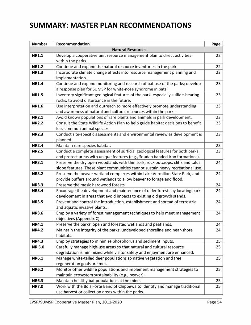
LVSP/SUMSP Cooperative Master Plan, 2011-2020 Page 54
SUMMARY: MASTER PLAN RECOMMENDATIONS
Number Recommendation Page Natural Resources NR1.1 Develop a cooperative unit resource management plan to direct activities
within the parks. 22
NR1.2 Continue and expand the natural resource inventories in the park. 22 NR1.3 Incorporate climate change effects into resource management planning and
implementation. 23
NR1.4 Continue and expand monitoring and research of bat use of the parks; develop a response plan for SUMSP for white-nose syndrome in bats.
23
NR1.5 Inventory significant geological features of the park, especially sulfide-bearing rocks, to avoid disturbance in the future.
23
NR1.6 Use interpretation and outreach to more effectively promote understanding and awareness of natural and cultural resources within the parks.
23
NR2.1 Avoid known populations of rare plants and animals in park development. 23 NR2.2 Consult the State Wildlife Action Plan to help guide habitat decisions to benefit
less-common animal species. 23
NR2.3 Conduct site-specific assessments and environmental review as development is planned.
23
NR2.4 Maintain rare species habitat. 23 NR2.5 Conduct a complete assessment of surficial geological features for both parks
and protect areas with unique features (e.g., Soudan banded iron formations). 23
NR3.1 Preserve the dry open woodlands with thin soils, rock outcrops, cliffs and talus slope features. These plant communities cannot sustain heavy recreational use.
24
NR3.2 Preserve the beaver wetland complexes within Lake Vermilion State Park, and provide buffers around wetlands to allow beaver to forage and flood.
24
NR3.3 Preserve the mesic hardwood forests. 24 NR3.4 Encourage the development and maintenance of older forests by locating park
development in areas that avoid impacts to existing old growth stands. 24
NR3.5 Prevent and control the introduction, establishment and spread of terrestrial and aquatic invasive plants.
24
NR3.6 Employ a variety of forest management techniques to help meet management objectives (Appendix C).
24
NR4.1 Preserve the parks’ open and forested wetlands and peatlands. 24 NR4.2 Maintain the integrity of the parks’ undeveloped shoreline and near-shore
habitats. 24
NR4.3 Employ strategies to minimize phosphorus and sediment inputs. 25 NR 5.0 Carefully manage high-use areas so that natural and cultural resource
degradation is minimized while visitor safety and enjoyment are enhanced. 25
NR6.1 Manage white-tailed deer populations so native vegetation and tree regeneration goals are met.
25
NR6.2 Monitor other wildlife populations and implement management strategies to maintain ecosystem sustainability (e.g., beaver).
25
NR6.3 Maintain healthy bat populations at the mine. 25 NR7.0 Work with the Bois Forte Band of Chippewa to identify and manage traditional
use harvest or collection areas within the parks. 25
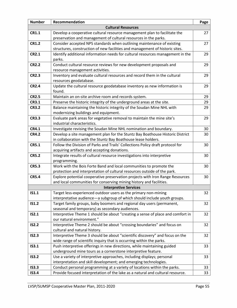
LVSP/SUMSP Cooperative Master Plan, 2011-2020 Page 55
Number Recommendation Page Cultural Resources CR1.1 Develop a cooperative cultural resource management plan to facilitate the
preservation and management of cultural resources in the parks. 27
CR1.2 Consider accepted NPS standards when outlining maintenance of existing structures, construction of new facilities and management of historic sites.
27
CR2.1 Identify additional information needs for cultural resources management in the parks.
29
CR2.2 Conduct cultural resource reviews for new development proposals and resource management activities.
29
CR2.3 Inventory and evaluate cultural resources and record them in the cultural resources geodatabase.
29
CR2.4 Update the cultural resource geodatabase inventory as new information is found.
29
CR2.5 Maintain an on-site archive room and records system. 29 CR3.1 Preserve the historic integrity of the underground areas at the site. 29 CR3.2 Balance maintaining the historic integrity of the Soudan Mine NHL with
modernizing buildings and equipment. 29
CR3.3 Evaluate park areas for vegetative removal to maintain the mine site’s industrial characteristics.
29
CR4.1 Investigate revising the Soudan Mine NHL nomination and boundary. 30 CR4.2 Develop a site management plan for the Stuntz Bay Boathouse Historic District
in collaboration with the Stuntz Bay Boathouse lease holders. 30
CR5.1 Follow the Division of Parks and Trails’ Collections Policy draft protocol for acquiring artifacts and accepting donations.
30
CR5.2 Integrate results of cultural resource investigations into interpretive programming.
30
CR5.3 Work with the Bois Forte Band and local communities to promote the protection and interpretation of cultural resources outside of the park.
30
CR5.4 Explore potential cooperative preservation projects with Iron Range Resources and local communities for conserving mining history and facilities.
30
Interpretive Services IS1.1 Target less-experienced outdoor users as the primary non-mining
interpretative audience—a subgroup of which should include youth groups. 32
IS1.2 Target family groups, baby boomers and regional day users (permanent, seasonal and temporary) as secondary audiences.
32
IS2.1 Interpretive Theme 1 should be about “creating a sense of place and comfort in our natural environment.”
32
IS2.2 Interpretive Theme 2 should be about “crossing boundaries” and focus on cultural and natural history.
32
IS2.3 Interpretive Theme 3 should be about “scientific discovery” and focus on the wide range of scientific inquiry that is occurring within the parks.
32
IS3.1 Push interpretive offerings in new directions, while maintaining guided underground mine tours as a cornerstone interpretive feature.
33
IS3.2 Use a variety of interpretive approaches, including displays; personal interpretation and skill development; and emerging technologies.
33
IS3.3 Conduct personal programming at a variety of locations within the parks. 33 IS3.4 Provide focused interpretation of the lake as a natural and cultural resource. 33
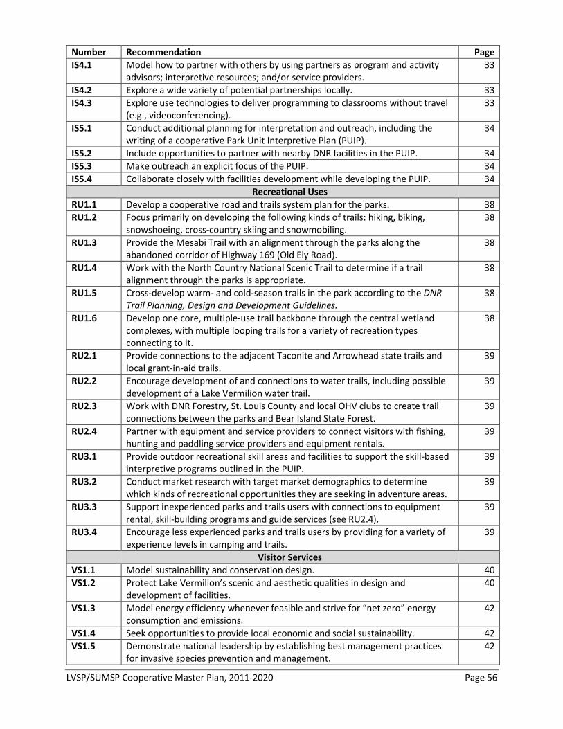
LVSP/SUMSP Cooperative Master Plan, 2011-2020 Page 56
Number Recommendation Page IS4.1 Model how to partner with others by using partners as program and activity
advisors; interpretive resources; and/or service providers. 33
IS4.2 Explore a wide variety of potential partnerships locally. 33 IS4.3 Explore use technologies to deliver programming to classrooms without travel
(e.g., videoconferencing). 33
IS5.1 Conduct additional planning for interpretation and outreach, including the writing of a cooperative Park Unit Interpretive Plan (PUIP).
34
IS5.2 Include opportunities to partner with nearby DNR facilities in the PUIP. 34 IS5.3 Make outreach an explicit focus of the PUIP. 34 IS5.4 Collaborate closely with facilities development while developing the PUIP. 34 Recreational Uses RU1.1 Develop a cooperative road and trails system plan for the parks. 38 RU1.2 Focus primarily on developing the following kinds of trails: hiking, biking,
snowshoeing, cross-country skiing and snowmobiling. 38
RU1.3 Provide the Mesabi Trail with an alignment through the parks along the abandoned corridor of Highway 169 (Old Ely Road).
38
RU1.4 Work with the North Country National Scenic Trail to determine if a trail alignment through the parks is appropriate.
38
RU1.5 Cross-develop warm- and cold-season trails in the park according to the DNR Trail Planning, Design and Development Guidelines.
38
RU1.6 Develop one core, multiple-use trail backbone through the central wetland complexes, with multiple looping trails for a variety of recreation types connecting to it.
38
RU2.1 Provide connections to the adjacent Taconite and Arrowhead state trails and local grant-in-aid trails.
39
RU2.2 Encourage development of and connections to water trails, including possible development of a Lake Vermilion water trail.
39
RU2.3 Work with DNR Forestry, St. Louis County and local OHV clubs to create trail connections between the parks and Bear Island State Forest.
39
RU2.4 Partner with equipment and service providers to connect visitors with fishing, hunting and paddling service providers and equipment rentals.
39
RU3.1 Provide outdoor recreational skill areas and facilities to support the skill-based interpretive programs outlined in the PUIP.
39
RU3.2 Conduct market research with target market demographics to determine which kinds of recreational opportunities they are seeking in adventure areas.
39
RU3.3 Support inexperienced parks and trails users with connections to equipment rental, skill-building programs and guide services (see RU2.4).
39
RU3.4 Encourage less experienced parks and trails users by providing for a variety of experience levels in camping and trails.
39
Visitor Services VS1.1 Model sustainability and conservation design. 40 VS1.2 Protect Lake Vermilion’s scenic and aesthetic qualities in design and
development of facilities. 40
VS1.3 Model energy efficiency whenever feasible and strive for “net zero” energy consumption and emissions.
42
VS1.4 Seek opportunities to provide local economic and social sustainability. 42 VS1.5 Demonstrate national leadership by establishing best management practices
for invasive species prevention and management. 42
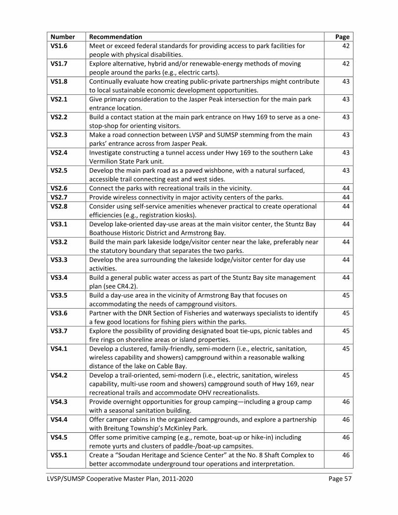
LVSP/SUMSP Cooperative Master Plan, 2011-2020 Page 57
Number Recommendation Page VS1.6 Meet or exceed federal standards for providing access to park facilities for
people with physical disabilities. 42
VS1.7 Explore alternative, hybrid and/or renewable-energy methods of moving people around the parks (e.g., electric carts).
42
VS1.8 Continually evaluate how creating public-private partnerships might contribute to local sustainable economic development opportunities.
43
VS2.1 Give primary consideration to the Jasper Peak intersection for the main park entrance location.
43
VS2.2 Build a contact station at the main park entrance on Hwy 169 to serve as a one-stop-shop for orienting visitors.
43
VS2.3 Make a road connection between LVSP and SUMSP stemming from the main parks’ entrance across from Jasper Peak.
43
VS2.4 Investigate constructing a tunnel access under Hwy 169 to the southern Lake Vermilion State Park unit.
43
VS2.5 Develop the main park road as a paved wishbone, with a natural surfaced, accessible trail connecting east and west sides.
43
VS2.6 Connect the parks with recreational trails in the vicinity. 44 VS2.7 Provide wireless connectivity in major activity centers of the parks. 44 VS2.8 Consider using self-service amenities whenever practical to create operational
efficiencies (e.g., registration kiosks). 44
VS3.1 Develop lake-oriented day-use areas at the main visitor center, the Stuntz Bay Boathouse Historic District and Armstrong Bay.
44
VS3.2 Build the main park lakeside lodge/visitor center near the lake, preferably near the statutory boundary that separates the two parks.
44
VS3.3 Develop the area surrounding the lakeside lodge/visitor center for day use activities.
44
VS3.4 Build a general public water access as part of the Stuntz Bay site management plan (see CR4.2).
44
VS3.5 Build a day-use area in the vicinity of Armstrong Bay that focuses on accommodating the needs of campground visitors.
45
VS3.6 Partner with the DNR Section of Fisheries and waterways specialists to identify a few good locations for fishing piers within the parks.
45
VS3.7 Explore the possibility of providing designated boat tie-ups, picnic tables and fire rings on shoreline areas or island properties.
45
VS4.1 Develop a clustered, family-friendly, semi-modern (i.e., electric, sanitation, wireless capability and showers) campground within a reasonable walking distance of the lake on Cable Bay.
45
VS4.2 Develop a trail-oriented, semi-modern (i.e., electric, sanitation, wireless capability, multi-use room and showers) campground south of Hwy 169, near recreational trails and accommodate OHV recreationalists.
45
VS4.3 Provide overnight opportunities for group camping—including a group camp with a seasonal sanitation building.
46
VS4.4 Offer camper cabins in the organized campgrounds, and explore a partnership with Breitung Township’s McKinley Park.
46
VS4.5 Offer some primitive camping (e.g., remote, boat-up or hike-in) including remote yurts and clusters of paddle-/boat-up campsites.
46
VS5.1 Create a “Soudan Heritage and Science Center” at the No. 8 Shaft Complex to better accommodate underground tour operations and interpretation.
46
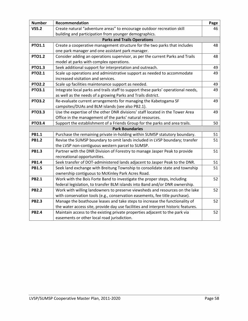
LVSP/SUMSP Cooperative Master Plan, 2011-2020 Page 58
Number Recommendation Page VS5.2 Create natural “adventure areas” to encourage outdoor recreation skill
building and participation from younger demographics. 46
Parks and Trails Operations PTO1.1 Create a cooperative management structure for the two parks that includes
one park manager and one assistant park manager. 48
PTO1.2 Consider adding an operations supervisor, as per the current Parks and Trails model at parks with complex operations.
48
PTO1.3 Seek additional support for interpretation and outreach. 49 PTO2.1 Scale up operations and administrative support as needed to accommodate
increased visitation and services. 49
PTO2.2 Scale up facilities maintenance support as needed. 49 PTO3.1 Integrate local parks and trails staff to support these parks’ operational needs,
as well as the needs of a growing Parks and Trails district. 49
PTO3.2 Re-evaluate current arrangements for managing the Kabetogama SF campsites/DUAs and BLM islands (see also PB2.1).
49
PTO3.3 Use the expertise of the other DNR divisions’ staff located in the Tower Area Office in the management of the parks’ natural resources.
49
PTO3.4 Support the establishment of a Friends Group for the parks and area trails. 50 Park Boundaries PB1.1 Purchase the remaining private in-holding within SUMSP statutory boundary. 51 PB1.2
Revise the SUMSP boundary to omit lands included in LVSP boundary; transfer the LVSP non-contiguous western parcel to SUMSP.
51
PB1.3
Partner with the DNR Division of Forestry to manage Jasper Peak to provide recreational opportunities.
51
PB1.4 Seek transfer of DOT-administered lands adjacent to Jasper Peak to the DNR. 51 PB1.5
Seek land exchange with Breitung Township to consolidate state and township ownership contiguous to McKinley Park Acres Road.
51
PB2.1
Work with the Bois Forte Band to investigate the proper steps, including federal legislation, to transfer BLM islands into Band and/or DNR ownership.
52
PB2.2
Work with willing landowners to preserve viewsheds and resources on the lake with conservation tools (e.g., conservation easements, fee title purchase).
52
PB2.3
Manage the boathouse leases and take steps to increase the functionality of the water access site, provide day use facilities and interpret historic features.
52
PB2.4
Maintain access to the existing private properties adjacent to the park via easements or other local road jurisdiction.
52
LVSP/SUMSP Cooperative Master Plan, 2011-2020 Page 59
BIBLIOGRAPHY OF ASSOCIATED DOCUMENTS MN DNR, 2009. A Strategic Conservation Agenda, 2009-2013. Part I: Strategic Directions, Trends that
Shape DNR’s Mission and Conservation Strategies for the Future. MN DNR, 2008. Adapting to Change: Minnesota’s State Comprehensive Outdoor Recreation Plan, 2008-
2012. MN DNR, 2008. Forest Classification and Road / Trail Designation Plan for DNR Forestry-Administered
Lands in Northern St. Louis County. MN DNR, Division of Ecological Resources. 2006. Tomorrow’s Habitat for the Wild and Rare: An Action
Plan for Minnesota Wildlife, Comprehensive Wildlife Conservation Strategy. MN DNR, Division of Forestry. 2005. Border Lakes Subsection Forest Resource Management Plan: Strategic
Direction and Stand Selection Results. MN DNR, Division of Parks and Trails. 2010. Connecting People to Minnesota’s Great Outdoors: Ten-Year
Strategic State Parks and Trails Plan, 2011-2020. MN DNR, Division of Parks and Recreation. 2008. Minnesota State Parks Research Summary Report, 2007. MN DNR, Division of Parks and Recreation. 2007. Minnesota State Parks Strategic Plan, 2006-2011. MN DNR, Division of Parks and Recreation. 2002. Soudan Underground Mine State Park Management
Plan. MN DNR, Division of Parks and Recreation. 2001. Soudan Underground Mine State Park: Stuntz Bay
Boathouses, Lake Vermilion. Report to the Senate and House Environment and Natural Resource Policy and Finance Committees.
MN DNR, Division of Trails and Waterways. 2006. Trail Planning, Design and Development Guidelines. MN DNR, Minnesota County Biological Survey, Natural Heritage and Nongame Research Program. 2003.
Field Guide to the Native Plant Communities of Minnesota: The Laurentian Mixed Forest Province.
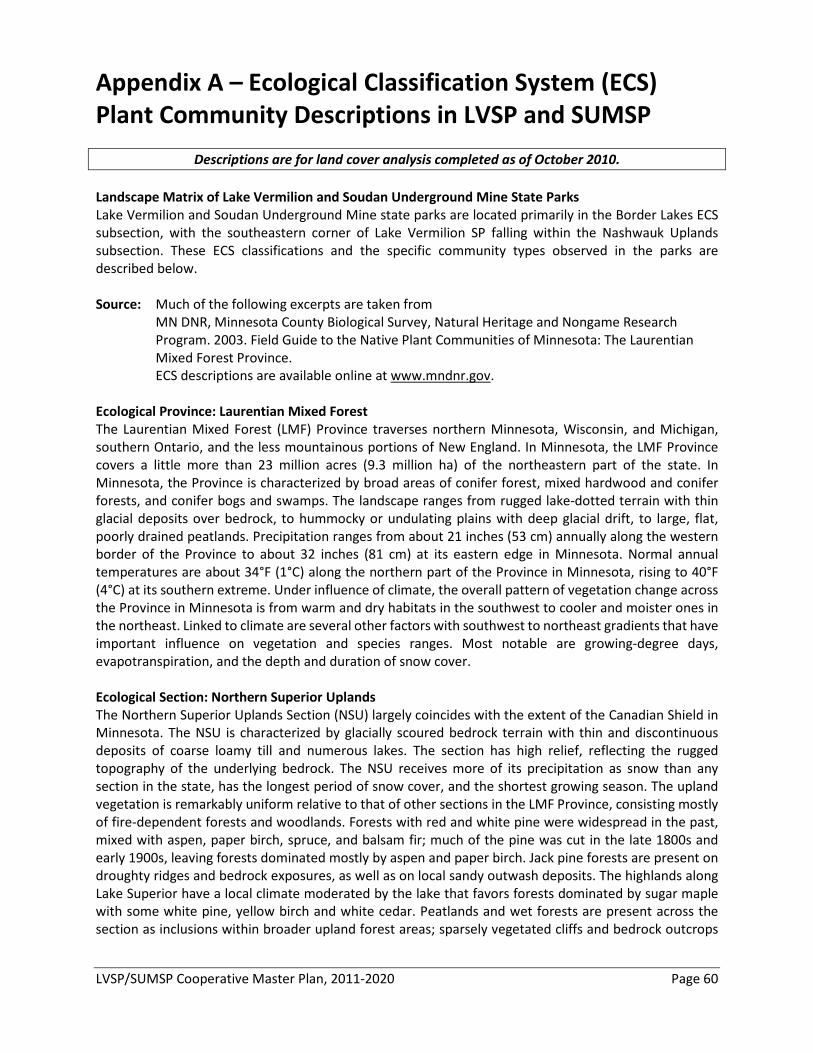
LVSP/SUMSP Cooperative Master Plan, 2011-2020 Page 60
Appendix A – Ecological Classification System (ECS) Plant Community Descriptions in LVSP and SUMSP
Descriptions are for land cover analysis completed as of October 2010. Landscape Matrix of Lake Vermilion and Soudan Underground Mine State Parks Lake Vermilion and Soudan Underground Mine state parks are located primarily in the Border Lakes ECS subsection, with the southeastern corner of Lake Vermilion SP falling within the Nashwauk Uplands subsection. These ECS classifications and the specific community types observed in the parks are described below. Source: Much of the following excerpts are taken from
MN DNR, Minnesota County Biological Survey, Natural Heritage and Nongame Research Program. 2003. Field Guide to the Native Plant Communities of Minnesota: The Laurentian Mixed Forest Province. ECS descriptions are available online at www.mndnr.gov.
Ecological Province: Laurentian Mixed Forest The Laurentian Mixed Forest (LMF) Province traverses northern Minnesota, Wisconsin, and Michigan, southern Ontario, and the less mountainous portions of New England. In Minnesota, the LMF Province covers a little more than 23 million acres (9.3 million ha) of the northeastern part of the state. In Minnesota, the Province is characterized by broad areas of conifer forest, mixed hardwood and conifer forests, and conifer bogs and swamps. The landscape ranges from rugged lake-dotted terrain with thin glacial deposits over bedrock, to hummocky or undulating plains with deep glacial drift, to large, flat, poorly drained peatlands. Precipitation ranges from about 21 inches (53 cm) annually along the western border of the Province to about 32 inches (81 cm) at its eastern edge in Minnesota. Normal annual temperatures are about 34°F (1°C) along the northern part of the Province in Minnesota, rising to 40°F (4°C) at its southern extreme. Under influence of climate, the overall pattern of vegetation change across the Province in Minnesota is from warm and dry habitats in the southwest to cooler and moister ones in the northeast. Linked to climate are several other factors with southwest to northeast gradients that have important influence on vegetation and species ranges. Most notable are growing-degree days, evapotranspiration, and the depth and duration of snow cover. Ecological Section: Northern Superior Uplands The Northern Superior Uplands Section (NSU) largely coincides with the extent of the Canadian Shield in Minnesota. The NSU is characterized by glacially scoured bedrock terrain with thin and discontinuous deposits of coarse loamy till and numerous lakes. The section has high relief, reflecting the rugged topography of the underlying bedrock. The NSU receives more of its precipitation as snow than any section in the state, has the longest period of snow cover, and the shortest growing season. The upland vegetation is remarkably uniform relative to that of other sections in the LMF Province, consisting mostly of fire-dependent forests and woodlands. Forests with red and white pine were widespread in the past, mixed with aspen, paper birch, spruce, and balsam fir; much of the pine was cut in the late 1800s and early 1900s, leaving forests dominated mostly by aspen and paper birch. Jack pine forests are present on droughty ridges and bedrock exposures, as well as on local sandy outwash deposits. The highlands along Lake Superior have a local climate moderated by the lake that favors forests dominated by sugar maple with some white pine, yellow birch and white cedar. Peatlands and wet forests are present across the section as inclusions within broader upland forest areas; sparsely vegetated cliffs and bedrock outcrops

LVSP/SUMSP Cooperative Master Plan, 2011-2020 Page 61
are common in the rugged terrain along Lake Superior and in the border lakes region of the northern part of the section. Ecological Subsections: Border Lakes and Nashwauk Uplands Border Lakes Subsection Lakes and rocky ridges characterize this landscape of glacially-eroded bedrock and poor soils. Historic forest types on uplands were mostly aspen-birch, aspen-birch-conifer, and on dry sites, jack pine barrens. Much of this subsection consists of the BWCAW, which is an internationally known wilderness area. Recreation, tourism, and forestry are the major land uses. The extent of this subsection was determined primarily by the extent of the bedrock controlled landscape. The southern and western boundaries were based on LTA-level boundaries on the Superior National Forest. This subsection consists of scoured bedrock uplands or shallow soils on bedrock, with large numbers of lakes. Glacial ice moved from west to east across the subsection, deepening stream valleys in the bedrock. Long, east-west oriented lakes now occupy these enlarged valleys. Topography is dominantly rolling with irregular slopes and many craggy outcrops of bedrock. The soils are derived from a mantle of acid, cobbly, and gravelly glacial till of variable depth. Coarse-loamy to coarse soil textures are most common. There are small areas of sandy and clayey lacustrine soil in the western portion of the subsection. About 5% of the unit is occupied by organic soils. There are over 300 lakes larger than 160 acres; these cover about 13% of the subsection's surface. The drainage network is very angular due to development in shallow sediments over bedrock. Rivers traversing this subsection include the Vermilion, Sioux, Moose, Portage, Kiwishiwi, and Brule. Major forest communities include jack pine forest, white pine-red pine forest, and hardwood-conifer forest. The latter community was dominated by balsam fir, white spruce, paper birch, and quaking aspen. Fire dependence characterizes all of these forest types. Nashwauk Uplands Subsection Brown glacial sediments form the parent material for much of this subsection. Landforms include end moraines, outwash plains, and lake plains formed by the Rainy Lobe glacier. Bedrock is locally exposed in the end moraines. Small bogs and potholes are common. Thickness of glacial drift is quite variable across the subsection. Soils are varied and range from medium to coarse textures. One unique aspect of this region is the Giants Range, where the majority of iron mining in Minnesota takes place. It is a high, narrow ridge trending northeast to southwest and caused by bedrock. This region consisted of forest communities dominated by white pine, red pine, balsam fir, white spruce, and aspen-birch. Wetland vegetation included conifer bogs and swamps. The western and part of the northern boundary is formed by the limit of the Nashwauk Moraine. Giants Range has a thin blanket of drift over granite. Immediately to the south is the iron-formation of the Iron Range, which has been heavily mined, first for "soft" iron ore and later for taconite. Soils are formed in sandy to fine-loamy glacial till and outwash sand. There are over 63 lakes greater than 100 acres in size in this subsection. Many are found on the Nashwauk Moraine. The Continental Divide follows the summit of Giant's Range. Water flowing north eventually goes into Hudson Bay. On the west side, waters flow into the Mississippi River watershed. To the south, water flows into Lake Superior. Northern Dry-Bedrock Pine (Oak) Woodland (FDn22) Dry pine or oak woodlands on shallow, excessively drained, loamy soils on bedrock ridges and hillsides or on rock ledges and terraces adjacent to rivers. Crown and surface fires were common historically.
FDn22b Red Pine - White Pine Woodland (Northeastern Bedrock) Canopy is dominated by white pine or red pine, often in mixed stands. Deciduous trees are uncommon in the canopy. Canopy and understory are relatively open, and white pine
LVSP/SUMSP Cooperative Master Plan, 2011-2020 Page 62
regeneration is common. Many sites have all age classes of white pine and, to a lesser extent, red pine. Documented in the Border Lakes Subsection in NSU. Description is based on summary of vegetation data from 5 plots. FDn22c Pin Oak Woodland (Bedrock) Canopy is typically dominated by short, scrubby northern pin oak or, less frequently, bur oak. Jack pine, red pine, and paper birch are occasionally present in the canopy. Downy arrowwood (Viburnum rafinesquianum) is common and abundant in FDn22c relative to other community types in this class; wild roses, red raspberry, bastard toadflax, American vetch, and harebell are also reasonably good indicators of FDn22c when present, but see also FDn22a above. Documented in the western part of the Border Lakes Subsection in NSU. Description is based on summary of vegetation data from 11 plots.
Northern Poor Dry-Mesic Mixed Woodland (FDn32) Dry-mesic pine or black spruce woodlands, often mixed with paper birch and quaking aspen. Most common on relatively nutrient-poor, shallow, loamy soils over bedrock, but also present on sandy lacustrine plains. Crown and surface fires were common historically.
FDn32a Red Pine - White Pine Woodland (Canadian Shield) Pine woodlands on excessively drained upper slopes and broad ridgetops. Canopy is strongly dominated by red pine and white pine with occasional black spruce or white spruce. FDn32a appears to be limited to NSU, where it has been documented mainly in the western and central portions of the Border Lakes Subsection. Description is based on summary of vegetation data from 17 plots.
Northern Mesic Mixed Forest (FDn43) Mesic pine, aspen, white cedar, or birch forests on loamy soils over bedrock in scoured bedrock uplands and on loamy, rocky, or sandy soils on glacial moraines, till plains, and outwash plains. Crown and severe surface fires were common historically.
FDn43a White Pine - Red Pine Forest Canopy is dominated by white pine and red pine with occasional paper birch, balsam fir, white spruce, quaking aspen, or white cedar. Balsam fir is also common in the subcanopy and shrub layer. FDn43a is best distinguished from other community types in the class by the presence of white pine and red pine in the canopy, and pipsissewa (Chimaphila umbellata) in the ground layer. FDn43a is common in NSU; it has also been documented but is uncommon in MOP, MDL, and WSU. Description is based on summary of vegetation data from 67 plots. FDn43b Aspen-Birch Forest Canopy is dominated by quaking aspen, paper birch, balsam fir, or white spruce. FDn43b is divided into two subtypes. FDn43b1 Balsam Fir Subtype Canopy is dominated by quaking aspen or paper birch, less frequently by balsam fir or white spruce. Balsam fir, quaking aspen, and paper birch are common in the understory. Blueberries (Vaccinium myrtilloides and V. angustifolium), ground pines, ground cedars, or clubmosses (Lycopodium spp.), red maple (especially in the canopy), and balsam fir are much more important in FDn43b1 than FDn43b2 and help to distinguish the two subtypes. FDn43b1 can have an understory that is floristically similar to White Pine - Red Pine Forests (see FDn43a above);
LVSP/SUMSP Cooperative Master Plan, 2011-2020 Page 63
however, FDn43b1 is less likely to have abundant red pine or white pine in the canopy and also generally lacks pipsissewa in the ground layer. Documented throughout NSU and the northern part of MDL; occasional in the eastern part of MOP and MDL. Description is based on summary of vegetation data from 69 plots.
Northern Mesic Hardwood Forest (MHn) Mesic to dry-mesic hardwood forests on well-drained to moderately well drained loamy soils, most often on stagnation moraines and till plains and less frequently on bedrock hills.
MHn35a Aspen - Birch - Basswood Forest Canopy is composed of variable mixtures of paper birch, sugar maple, basswood, quaking aspen, and red maple, with northern red oak, bur oak, big-toothed aspen, and white pine sometimes important. Sugar maple is often abundant in the subcanopy. Beaked hazelnut, mountain maple (Acer spicatum), bush honeysuckle (Diervilla lonicera), and round-leaved dogwood (Cornus rugosa) tend to be more abundant in the shrub layer in MHn35a than in MHn35b. Likewise, wild sarsaparilla, large-leaved aster, and Canada mayflower are considerably more abundant in the ground layer in MHn35a, together usually providing more than one-half of the ground-layer cover. When present, prickly or smooth wild rose (Rosa acicularis or R. blanda), trailing blackberries (Rubus flagellaris and similar Rubus species), bunchberry (Cornus canadensis), and wild ginger (Asarum canadense) help to distinguish MHn35a from MHn35b. The range of MHn35a is centered in the MDL, but MHn35a also occurs in the WSU, SSU, and northern MIM. Description is based on summary of vegetation data from 125 plots.
Northern Wet Cedar Forest (WFn53) Wet conifer or conifer-hardwood forests on muck or peat soils. Typically present in settings where saturated soils are present through most of the growing season such as depressions; low, level terrain along lakes, rivers, or wetlands; and gently sloping upland drains.
WFn53b Lowland White Cedar Forest (Northern) Canopy is dominated by white cedar, sometimes with abundant black ash. Balsam fir and paper birch are occasionally present in the canopy. White cedar, balsam fir, and black ash are sometimes abundant in the subcanopy, but most often the community is relatively open below the canopy. WFn53b generally occurs to the west of WFn53a, but where the ranges of the two types overlap in the NSU, WFn53b can often be distinguished by the absence of the indicator species listed above for WFn53a and the presence of rattlesnake fern (Botrychium virginianum), common strawberry (Fragaria virginiana), touch-me-nots (Impatiens spp.), or red baneberry (Actaea rubra). Other species that help to differentiate WFn53b from WFn53a, when present, include American elm in the understory, lowbush blueberry (Vaccinium angustifolium), northern bugleweed (Lycopus uniflorus), and northern marsh fern (Thelypteris palustris). WFn53b is widespread, occurring in the MDL, WSU, MOP, the central and western portions of the NSU, and very locally in the LAP and in the Hardwood Hills and Anoka Sand Plain Subsections in the MIM. Description is based on summary of vegetation data from 69 plots.
LVSP/SUMSP Cooperative Master Plan, 2011-2020 Page 64
Northern Wet Ash Swamp (WFn55) Wet hardwood forests on mucky mineral soils in shallow basins and groundwater seepage areas and on low, level terrain near rivers, lakes, or wetlands. Typically with standing water in the spring but draining by late summer.
WFn55a Black Ash - Aspen - Balsam Poplar Swamp (Northeastern) Wet-mesic to wet forests. Typically with black ash and other hardwood species as canopy dominants, occasionally with minor amounts of white spruce or white cedar. WFn55a includes some poorly drained quaking aspen forests, and most (if not all) occurrences of WFn55 in which balsam poplar is dominant in the canopy. Grasses and sedges are relatively important in the ground layer. Speckled alder (Alnus incana), red raspberry (Rubus strigosus), and bluejoint (Calamagrostis canadensis) are more common and abundant in WFn55a than in other community types in this class. When present, quaking aspen, balsam poplar, round-leaved dogwood (Cornus rugosa), prickly or smooth wild rose (Rosa acicularis or R. blanda), fringed loosestrife (Lysimachia ciliata), panicled bluebells (Mertensia paniculata), rugulose or yellow violet (Viola canadensis or V. pubescens), and cow parsnip (Heracleum lanatum) are useful in differentiating WFn55a from the other community types in this class. WFn55a occurs in shallow basins and level to gently sloping groundwater seepage areas. WFn55a has been documented in the NSU, WSU, MDL, and MOP. Description is based on summary of vegetation data from 30 plots.
Northern Very Wet Ash Swamp (WFn64) Wet hardwood or hardwood-conifer forests on peaty soils in small closed depressions or around the edges of large peatlands. Typically with standing water present throughout spring and summer.
WFn64a Black Ash - Conifer Swamp (Northeastern) Wet to very wet forests heavily dominated by black ash. Conifers, especially balsam fir and white cedar, are often present in the understory and may be present in the canopy. Shrub layer is well developed, with mountain maple and speckled alder abundant. Species useful in distinguishing WFn64a from WFn64b or WFn64c include balsam fir, white cedar, and common oak fern (Gymnocarpium dryopteris). When present, long beech fern (Phegopteris connectilis), goldthread (Coptis trifolia), bluebead lily (Clintonia borealis), nodding trillium (Trillium cernuum), and rose twistedstalk (Streptopus roseus) also help to distinguish WFn64a from other types in the community class. WFn64a occurs across northern Minnesota; it has been documented in the NSU, SSU, WSU, MDL, MOP, and in the Hardwood Hills Subsection in the MIM. Description is based on summary of vegetation data from 47 plots.
Northern Wet Alder Swamp (WFn74) WFn74, like FPn73, is a shrub wetland community dominated by speckled alder. WFn74, however, tends to occur along streams and lakes or in wetlands associated with deciduous swamp forests and typically has species characteristic of mesic upland communities. Forested Rich Peatland (FP) Forested Rich Peatland (FP) communities are conifer- or tall shrub–dominated wetlands on deep (>15in [40cm]), actively forming peat. They are characterized by mossy ground layers, often with abundant shrubs and forbs. FP communities are widespread in the Laurentian Mixed Forest Province but extend only into the northern half of the Eastern Broadleaf (EBF) Province. The warmer climate of the EBF Province, less
LVSP/SUMSP Cooperative Master Plan, 2011-2020 Page 65
abundant precipitation, and absence of poorly drained glacial lake plains limit peat development relative to the northern part of Minnesota, making FP communities much less common.
FPn62a Rich Black Spruce Swamp (Basin) Black spruce–dominated swamps on deep peat in small basins on scoured bedrock terrain or on till plains. Peat surface is influenced by mineral-rich groundwater or surface runoff. FPn62a is the only community type recognized in this class at present. Collection of additional data may provide justification for further splitting. Sites closer to Lake Superior, particularly those in the North Shore Highlands Subsection in NSU, appear wetter, shadier, and richer based on synecological coordinates (i.e., plant indicators) than those farther west in Voyageurs National Park. In addition, other classifications in Ontario and Minnesota recognize tall-shrub and herb-rich types of rich black spruce swamps, which were not apparent in analysis of relevé data used in this classification.
Northern Cedar Swamp (FPn63) White cedar–dominated swamps on wet peat soils. Often present in areas influenced by mineral-rich subsurface flow or groundwater seepage along the margins of uplands and peatlands.
Northern Rich Alder Swamp (FPn73) Tall shrub wetlands dominated by speckled alder on mineral, muck, or peat soils. Present in wetland basins on glacial moraines and till plains, along streams and drainage ways, and in laggs along peatland and upland borders. Northern Poor Conifer Swamp (APn81) Conifer-dominated peatlands with sparse canopy of stunted trees. Understory is depauperate and dominated by ericaceous shrubs, fine-leaved graminoids, and low Sphagnum hummocks. Minerotrophic plant species are present.
APn81a Poor Black Spruce Swamp Tree canopy has > 50% cover, typically dominated by black spruce, occasionally with tamarack (which rarely may be codominant). Paper birch is also occasionally present in the canopy. Tall shrubs are usually absent or infrequent. APn81a occurs in slightly drier areas than APn81b and as a result has a denser tree canopy and greater presence of shade-tolerant species in the understory, including Indian pipe, creeping snowberry, ferns (especially Dryopteris spp.), lingonberry (Vaccinium vitis-idaea), soft-leaved sedge (Carex disperma), clubmosses and groundpines (Lycopodium spp.), bunchberry (Cornus canadensis), juneberries (Amelanchier spp.), and balsam fir. Description is based on summary of vegetation data from 21 plots. APn81b Poor Tamarack - Black Spruce Swamp Tree canopy has 25–50% cover and is dominated by black spruce with occasional tamarack, or by tamarack with black spruce. APn81b develops in slightly wetter areas than APn81a. Because of this, APn81b has a more open canopy and more light-demanding species in the understory, including bog rosemary, creeping sedge (Carex chordorrhiza), bog birch, bog wiregrass sedge (C. oligosperma), lake sedge (C. lacustris), few-fruited sedge (C. pauciflora), bog willow (Salix pedicellaris), buckbean (Menyanthes trifoliata), and bog laurel (Kalmia polifolia). APn81b is divided into two subtypes, based on differences in the abundance of black spruce and tamarack in the tree canopy.
LVSP/SUMSP Cooperative Master Plan, 2011-2020 Page 66
Northern Poor Fen (APn91) Open Sphagnum peatlands with variable development of hummocks and hollows. Dominated either by fine-leaved sedges or low ericaceous shrubs. Present in small basins, on floating mats near lakes and ponds, and in large peatlands on glacial lake plains.
APn91a Low Shrub Poor Fen Open peatlands with cover of leatherleaf and bog birch either > 50% or greater than cover of graminoids, although tussock cottongrass (Eriophorum vaginatum) and tawny cottongrass (E. virginicum) can be abundant in the graminoid layer. Stunted black spruce and tamarack are often present. Sphagnum hummocks are moderately well developed. Indicator species characteristic of wet hollows are absent or rare. APn91a is present in smaller peatland basins, on floating mats adjacent to ponds and lakes, and at margins or in strings in larger peatlands. Description is based on summary of vegetation data from 76 plots.
Northern Dry Cliff (CTn11) Open plant communities on dry south- to west-facing, sunny cliffs in rugged terrain in northeastern and, rarely, east-central Minnesota. Vascular plants are largely restricted to crevices and ledges.
CTn11a Dry Mafic Cliff (Northern) Open communities on dry, circumneutral to moderately alkaline cliffs composed of diabase, basalt, gabbro, diorite, andesite, anorthosite, or greenstone. CTn11a is the most common dry cliff type in the North Shore Highlands and much of the Border Lakes subsections in NSU. Early goldenrod is present on most occurrences and red pines are often present on cliff tops. On cliffs in the Rove Landtype Association in the eastern Border Lakes Subsection, CTn11a often occurs as cap of erosion-resistant diabase above a more erodible layer of shale, argillite, or graywacke (see CTn11b below). A southern outlier of CTn11a is present along the St. Croix River at Taylors Falls in WSU.
Northern Open Talus (CTn12) Open plant communities on steep talus slopes, usually below cliffs or rock outcrops. Dominated by lichens or mosses, with sparse cover of trees or herbaceous plants. Most common in rugged terrain in northeastern Minnesota.
CTn12a Dry Open Talus (Northern) Dry, open communities with little or no shrub or tree cover. Lichens are the predominant cover, with fruticose species common, including reindeer lichens. Vascular plants and mosses are uncommon and very sparse. Talus fragments are generally moderate to large (6in to >60in [15cm to >150cm] in diameter). CTn12a occurs on steep slopes below cliffs of all aspects (although it is more common on south- to west-facing aspects) in the North Shore Highlands and Border Lakes subsections in NSU.
LVSP/SUMSP Cooperative Master Plan, 2011-2020 Page 67
Northern Mesic Cliff (CTn32) Open plant communities on dry-mesic to mesic, northwest- to east-facing, shaded cliffs in rugged terrain in northeastern and, rarely, east-central Minnesota. Vascular plants are largely restricted to crevices and ledges. Northern Bedrock Outcrop (Ron12) Dry, open, lichen-dominated plant communities on areas of exposed bedrock. Woody vegetation is sparse and vascular plants are restricted to crevices and shallow soil deposits.
ROn12b Crystalline Bedrock Outcrop (Northern) Small (<2 acres), open communities with little or no (0-25%) shrub or tree cover on dry exposures of crystalline bedrock. Common rock types include diabase, basalt, gabbro, granite, and greenstone. Less common rock types include anorthosite, rhyolite, diorite, andesite, granodiorite, granophyre, tonalite, and graywacke. Crustose lichens are the predominant cover, with foliose and fruticose species (including reindeer moss) common. Vascular plant cover is low, with plants restricted to crevices and shallow soil deposits. Characteristic species include lowbush blueberry, bristly sarsaparilla, pale corydalis, fringed false buckwheat, and rock spikemoss. Orchids including stemless lady’s slipper (Cypripedium acaule), green adder’s mouth (Malaxis unifolia), northern slender ladies’ tresses (Spiranthes lacera), and hooded ladies’ tresses (S. romanzoffiana) may occur in ROn12b. ROn12b occurs in small openings in woodlands or forests throughout much of northeastern Minnesota.
Northern Bedrock Shrubland (ROn23) Dry to dry-mesic, shrub-dominated communities on sites with exposed bedrock and shallow soils in northeastern Minnesota.
ROn23a Bedrock Shrubland (Inland) Small- to medium-sized (1 to >25 acres) shrub-dominated communities on sites with exposed bedrock and shallow soils, most often on ridgetops, summits, slopes, and cliff tops. Shrubs are dominant where deeper soil is present and generally have 25-75% overall cover. Scattered small, often open-grown trees are also present. Herbaceous plants are sparse and generally restricted to crevices and areas of shallow soil. Characteristic vascular plant species include big-toothed aspen, northern red oak, northern pin oak, juneberries, bush honeysuckle, hairy honeysuckle (Lonicera hirsuta), blueberries (Vaccinium angustifolium, V. myrtilloides), three-toothed cinquefoil (Potentilla tridentata), bearberry (Arctostaphylos uva-ursi), large-leaved aster, poverty grass, and Back’s sedge (Carex backii). Crustose lichens are dominant on areas of exposed bedrock, with fruticose and foliose lichens also important. Although no quantitative data exist, lichens and mosses generally appear to be less diverse in ROn23a than in ROn23b. Evidence of fire is common. ROn23a is present occasionally throughout the inland portion of the North Shore Highlands Subsection of NSU; ROn23a may also be present in the Laurentian Uplands, Border Lakes, and Toimi Uplands subsections of NSU, and in MOP, SSU, and WSU.
LVSP/SUMSP Cooperative Master Plan, 2011-2020 Page 68
Northern Shrub Shore Fen (OPn81) Shrub-dominated peatlands on floating mats along margins of peatlands in ponds, lakes, and streams.
OPn81b Leatherleaf - Sweet Gale Shore Fen Shrub-dominated fens with Sphagnum cover > 50% and often nearly continuous. Ericaceous shrubs are typically present, including bog rosemary (Andromeda glaucophylla), Labrador tea (Ledum groenlandicum), small cranberry (Vaccinium oxycoccos), or leatherleaf, along with red-osier dogwood and speckled alder. Characteristic forbs include bog goldenrod (Solidago uliginosa), three-leaved false Solomon’s seal (Smilacina trifolia), poor sedge (Carex paupercula), and pitcher plant (Sarracenia purpurea). Description is based on summary of vegetation data from 27 plots.
Northern Wet Meadow/Carr (WMn82) Open wetlands dominated by dense cover of broad-leaved graminoids or tall shrubs. Present on mineral to sapric peat soils in basins and along streams.
WMn82a Willow - Dogwood Shrub Swamp Open wetlands with abundant broad-leaved graminoids, and shrub cover typically > 25%. Shrubs that may be abundant include willows, red-osier dogwood, speckled alder, and occasionally bog birch. Description is based on summary of vegetation data from 69 plots. WMn82b Sedge Meadow Open wetlands with abundant broad-leaved graminoids, and shrub cover typically < 25%. The invasive species common reed grass (Phragmites australis) and reed canary grass (Phalaris arundinacea) have become increasingly abundant in this community type over the past several decades, reducing species diversity in many occurrences. WMn82b is divided into four subtypes, based on dominant graminoid species. Description is based on summary of vegetation data from 224 plots. WMn82b1 Bluejoint Subtype WMn82b3 Beaked Sedge Subtype
Beaver Wetland Complex (BV_CX) This mapping unit consists of a complex of small to medium-sized wetlands whose character has been altered or is influenced by beaver-created impoundments, usually along watershed drainages. These are generally unforested wetlands, though trees and shrubs may have been common prior to beaver impoundment. Standing dead trees (snags), shrubs and downed wood are common in many of these wetlands. Patches of open water occur directly behind the dam. Cattails, lake sedge, and other tussock-forming sedges are often dominant in the wettest zones near the dam. Slightly drier zones often support speckled alder or bluejoint. Remnants of the wetland communities present before flooding by beaver are sometimes found at higher elevations in the watershed upstream from the dam. Wetland community types that are frequently inundated by beavers include alder swamp, wet meadow, poor and rich fen, wet cedar forest, tamarack and black spruce swamp. (B. Carlson and L.B. Gerdes, MCBS)
LVSP/SUMSP Cooperative Master Plan, 2011-2020 Page 69
Appendix B – Species Lists
Bird List Common Name Scientific Name LVSP SUMSP Alder Flycatcher Empidonax alnorum American Black Duck Anas rubripes American Crow Corvus brachyrhynchos American Goldfinch Carduelis tristis American Kestrel Falco sparverius American Pipit Anthus rubescens American Redstart Setophaga ruticilla American Robin Turdus migratorius American Tree Sparrow Spizella arborea American Wigeon Anas americana American Woodcock Scolopax minor Bald Eagle Haliaeetus leucocephalus Baltimore Oriole Icterus galbula Barn Swallow Hirundo rustica Barred Owl Strix varia Belted Kingfisher Ceryle alcyon Black-and-white Warbler Mniotilta varia Blackburnian Warbler Dendroica fusca Black-capped Chickadee Poecile atricapillus Black-throated Green Wabler Dendroica virens Blue Jay Cyanocitta cristata Blue-headed Vireo Vireo solitarius Blue-winged Teal Anas discors Bobolink Dolichonyx oryzivorus Bohemian Waxwing Bombycilla garrulus Boreal Chickadee Poecile hudsonica Broad-winged Hawk Buteo platypterus Brown Creeper Certhia americana Brown-headed Cowbird Molothrus ater Bufflehead Bucephala albeola Canada Goose Branta canadensis Canada Warbler Wilsonia canadensis Cape May Warbler Dendroica tigrina Cedar Waxwing Bombycilla cedrorum Chestnut-sided Warbler Dendroica pensylvanica Chipping Sparrow Spizella passerina Clay-colored Sparrow Spizella pallida Cliff Swallow Petrochelidon pyrrhonota
LVSP/SUMSP Cooperative Master Plan, 2011-2020 Page 70
Common Name Scientific Name LVSP SUMSP Common Goldeneye Bucephala clangula Common Grackle Quiscalus quiscula Common Loon Gavia immer Common Merganser Mergus merganser Common Raven Corvus corax Common Yellowthroat Geothlypis trichas Dark-eyed Junco Junco hyemalis Double-crested Cormorant Phalacrocorax auritus Downy Woodpecker Picoides pubescens Eastern Bluebird Sialia sialis Eastern Kingbird Tyrannus tyrannus Eastern Phoebe Sayornis phoebe Eastern Wood-Pewee Contopus virens European Starling Sturnus vulgaris Evening Grosbeak Coccothraustes vespertinus Fox Sparrow Passerella iliaca Golden-crowned Kinglet Regulus satrapa Gray Catbird Dumetella carolinensis Gray Jay Perisoreus canadensis Gray-cheeked Thrush Catharus minimus Great Blue Heron Ardea herodias Great Crested Flycatcher Myiarchus crinitus Great Gray Owl Strix nebulosa Great Horned Owl Bubo virginianus Greater Scaup Aythya marila Greater Yellowlegs Tringa melanoleuca Green Heron Butorides virescens Green-winged Teal Anas crecca Hairy Woodpecker Picoides villosus Harris’s Sparrow Zonotrichia querula Hermit Thrush Catharus guttatus Herring Gull Larus argentatus Hooded Merganser Lophodytes cucullatus Horned Grebe Podiceps auritus House Finch Carpodacus mexicanus House Sparrow Passer domesticus House Wren Troglodytes aedon Killdeer Charadrius vociferus Lapland Longspur Calcarius lapponicus Least Flycatcher Empidonax minimus Least Sandpiper Calidris minutilla Lesser Scaup Aythya affinis
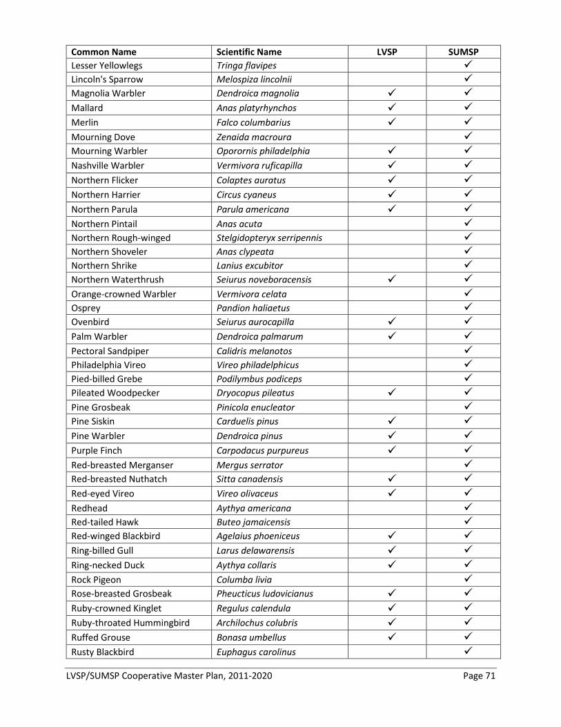
LVSP/SUMSP Cooperative Master Plan, 2011-2020 Page 71
Common Name Scientific Name LVSP SUMSP Lesser Yellowlegs Tringa flavipes Lincoln's Sparrow Melospiza lincolnii Magnolia Warbler Dendroica magnolia Mallard Anas platyrhynchos Merlin Falco columbarius Mourning Dove Zenaida macroura Mourning Warbler Oporornis philadelphia Nashville Warbler Vermivora ruficapilla Northern Flicker Colaptes auratus Northern Harrier Circus cyaneus Northern Parula Parula americana Northern Pintail Anas acuta Northern Rough-winged Stelgidopteryx serripennis Northern Shoveler Anas clypeata Northern Shrike Lanius excubitor Northern Waterthrush Seiurus noveboracensis Orange-crowned Warbler Vermivora celata Osprey Pandion haliaetus Ovenbird Seiurus aurocapilla Palm Warbler Dendroica palmarum Pectoral Sandpiper Calidris melanotos Philadelphia Vireo Vireo philadelphicus Pied-billed Grebe Podilymbus podiceps Pileated Woodpecker Dryocopus pileatus Pine Grosbeak Pinicola enucleator Pine Siskin Carduelis pinus Pine Warbler Dendroica pinus Purple Finch Carpodacus purpureus Red-breasted Merganser Mergus serrator Red-breasted Nuthatch Sitta canadensis Red-eyed Vireo Vireo olivaceus Redhead Aythya americana Red-tailed Hawk Buteo jamaicensis Red-winged Blackbird Agelaius phoeniceus Ring-billed Gull Larus delawarensis Ring-necked Duck Aythya collaris Rock Pigeon Columba livia Rose-breasted Grosbeak Pheucticus ludovicianus Ruby-crowned Kinglet Regulus calendula Ruby-throated Hummingbird Archilochus colubris Ruffed Grouse Bonasa umbellus Rusty Blackbird Euphagus carolinus
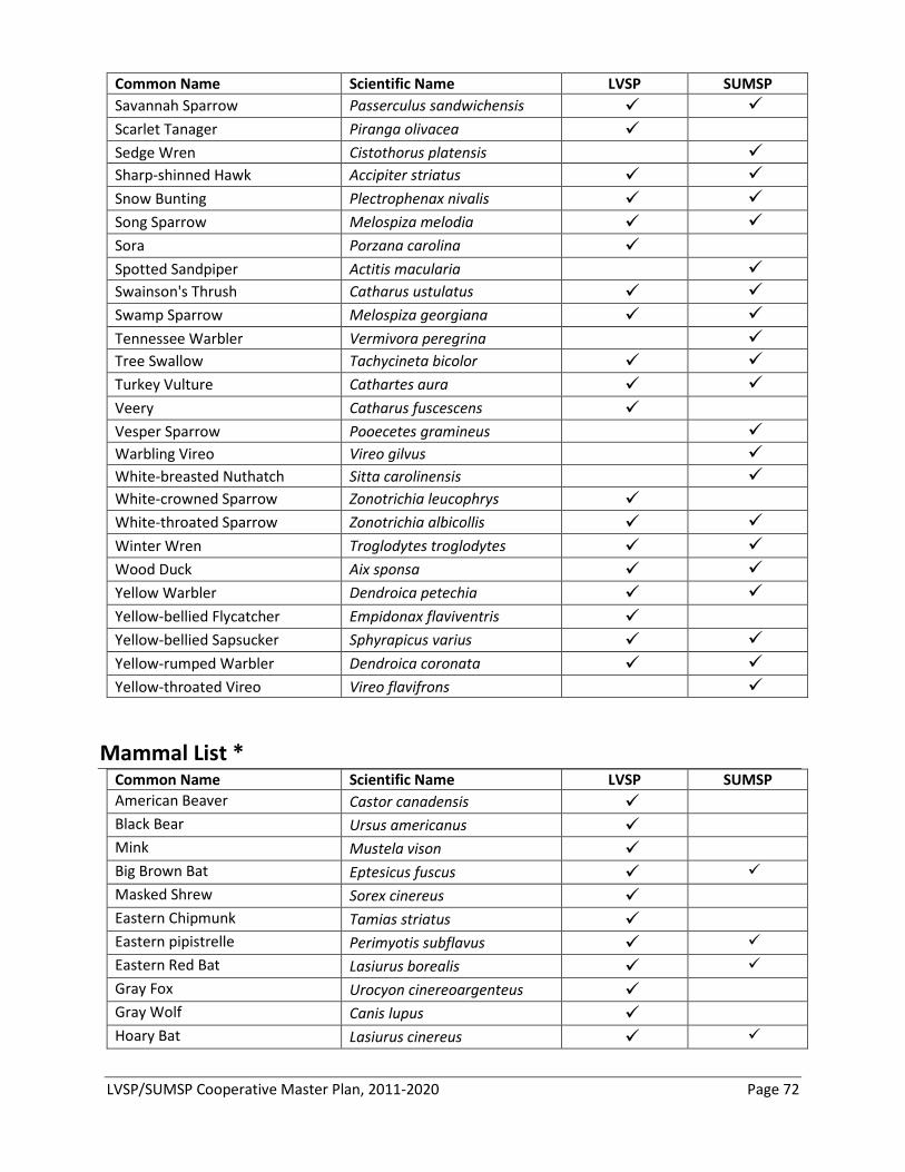
LVSP/SUMSP Cooperative Master Plan, 2011-2020 Page 72
Common Name Scientific Name LVSP SUMSP Savannah Sparrow Passerculus sandwichensis Scarlet Tanager Piranga olivacea Sedge Wren Cistothorus platensis Sharp-shinned Hawk Accipiter striatus Snow Bunting Plectrophenax nivalis Song Sparrow Melospiza melodia Sora Porzana carolina Spotted Sandpiper Actitis macularia Swainson's Thrush Catharus ustulatus Swamp Sparrow Melospiza georgiana Tennessee Warbler Vermivora peregrina Tree Swallow Tachycineta bicolor Turkey Vulture Cathartes aura Veery Catharus fuscescens Vesper Sparrow Pooecetes gramineus Warbling Vireo Vireo gilvus White-breasted Nuthatch Sitta carolinensis White-crowned Sparrow Zonotrichia leucophrys White-throated Sparrow Zonotrichia albicollis Winter Wren Troglodytes troglodytes Wood Duck Aix sponsa Yellow Warbler Dendroica petechia Yellow-bellied Flycatcher Empidonax flaviventris Yellow-bellied Sapsucker Sphyrapicus varius Yellow-rumped Warbler Dendroica coronata Yellow-throated Vireo Vireo flavifrons
Mammal List * Common Name Scientific Name LVSP SUMSP American Beaver Castor canadensis Black Bear Ursus americanus Mink Mustela vison Big Brown Bat Eptesicus fuscus Masked Shrew Sorex cinereus Eastern Chipmunk Tamias striatus Eastern pipistrelle Perimyotis subflavus Eastern Red Bat Lasiurus borealis Gray Fox Urocyon cinereoargenteus Gray Wolf Canis lupus Hoary Bat Lasiurus cinereus
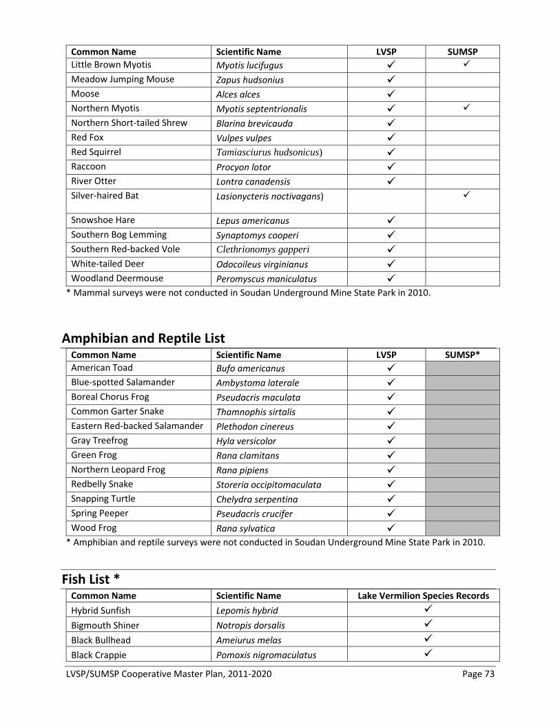
LVSP/SUMSP Cooperative Master Plan, 2011-2020 Page 73
Common Name Scientific Name LVSP SUMSP Little Brown Myotis Myotis lucifugus Meadow Jumping Mouse Zapus hudsonius Moose Alces alces Northern Myotis Myotis septentrionalis Northern Short-tailed Shrew Blarina brevicauda Red Fox Vulpes vulpes Red Squirrel Tamiasciurus hudsonicus) Raccoon Procyon lotor River Otter Lontra canadensis Silver-haired Bat Lasionycteris noctivagans)
Snowshoe Hare Lepus americanus Southern Bog Lemming Synaptomys cooperi Southern Red-backed Vole Clethrionomys gapperi White-tailed Deer Odocoileus virginianus Woodland Deermouse Peromyscus maniculatus
* Mammal surveys were not conducted in Soudan Underground Mine State Park in 2010.
Amphibian and Reptile List Common Name Scientific Name LVSP SUMSP* American Toad Bufo americanus Blue-spotted Salamander Ambystoma laterale Boreal Chorus Frog Pseudacris maculata Common Garter Snake Thamnophis sirtalis Eastern Red-backed Salamander Plethodon cinereus Gray Treefrog Hyla versicolor Green Frog Rana clamitans Northern Leopard Frog Rana pipiens Redbelly Snake Storeria occipitomaculata Snapping Turtle Chelydra serpentina Spring Peeper Pseudacris crucifer Wood Frog Rana sylvatica
* Amphibian and reptile surveys were not conducted in Soudan Underground Mine State Park in 2010. Fish List *
Common Name Scientific Name Lake Vermilion Species Records Hybrid Sunfish Lepomis hybrid Bigmouth Shiner Notropis dorsalis Black Bullhead Ameiurus melas Black Crappie Pomoxis nigromaculatus
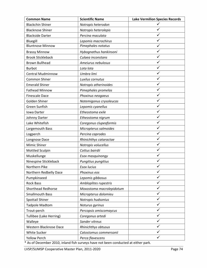
LVSP/SUMSP Cooperative Master Plan, 2011-2020 Page 74
Common Name Scientific Name Lake Vermilion Species Records Blackchin Shiner Notropis heterodon Blacknose Shiner Notropis heterolepis Blackside Darter Percina maculata Bluegill Lepomis macrochirus Bluntnose Minnow Pimephales notatus Brassy Minnow Hybognathus hankinsoni Brook Stickleback Culaea inconstans Brown Bullhead Ameiurus nebulosus Burbot Lota lota Central Mudminnow Umbra limi Common Shiner Luxilus cornutus Emerald Shiner Notropis atherinoides Fathead Minnow Pimephales promelas Finescale Dace Phoxinus neogaeus Golden Shiner Notemigonus crysoleucas Green Sunfish Lepomis cyanellus Iowa Darter Etheostoma exile Johnny Darter Etheostoma nigrum Lake Whitefish Coregonus clupeaformis Largemouth Bass Micropterus salmoides Logperch Percina caprodes Longnose Dace Rhinichthys cataractae Mimic Shiner Notropis volucellus Mottled Sculpin Cottus bairdii Muskellunge Esox masquinongy Ninespine Stickleback Pungitius pungitius Northern Pike Esox lucius Northern Redbelly Dace Phoxinus eos Pumpkinseed Lepomis gibbosus Rock Bass Ambloplites rupestris Shorthead Redhorse Moxostoma macrolepidotum Smallmouth Bass Micropterus dolomieu Spottail Shiner Notropis hudsonius Tadpole Madtom Noturus gyrinus Trout-perch Percopsis omiscomaycus Tullibee (Lake Herring) Coregonus artedi Walleye Sander vitreus Western Blacknose Dace Rhinichthys obtusus White Sucker Catostomus commersonii Yellow Perch Perca flavescens
* As of December 2010, inland fish surveys have not been conducted at either park.
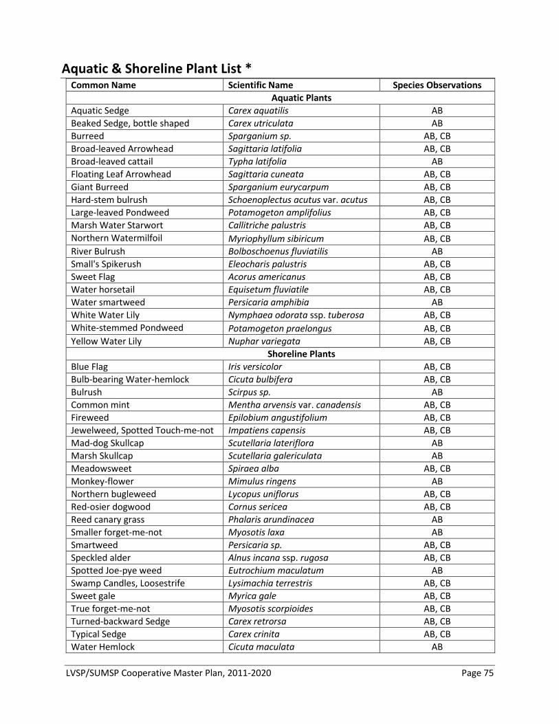
LVSP/SUMSP Cooperative Master Plan, 2011-2020 Page 75
Aquatic & Shoreline Plant List * Common Name Scientific Name Species Observations
Aquatic Plants Aquatic Sedge Carex aquatilis AB Beaked Sedge, bottle shaped Carex utriculata AB Burreed Sparganium sp. AB, CB Broad-leaved Arrowhead Sagittaria latifolia AB, CB Broad-leaved cattail Typha latifolia AB Floating Leaf Arrowhead Sagittaria cuneata AB, CB Giant Burreed Sparganium eurycarpum AB, CB Hard-stem bulrush Schoenoplectus acutus var. acutus AB, CB Large-leaved Pondweed Potamogeton amplifolius AB, CB Marsh Water Starwort Callitriche palustris AB, CB Northern Watermilfoil Myriophyllum sibiricum AB, CB River Bulrush Bolboschoenus fluviatilis AB Small's Spikerush Eleocharis palustris AB, CB Sweet Flag Acorus americanus AB, CB Water horsetail Equisetum fluviatile AB, CB Water smartweed Persicaria amphibia AB White Water Lily Nymphaea odorata ssp. tuberosa AB, CB White-stemmed Pondweed Potamogeton praelongus AB, CB Yellow Water Lily Nuphar variegata AB, CB Shoreline Plants Blue Flag Iris versicolor AB, CB Bulb-bearing Water-hemlock Cicuta bulbifera AB, CB Bulrush Scirpus sp. AB Common mint Mentha arvensis var. canadensis AB, CB Fireweed Epilobium angustifolium AB, CB Jewelweed, Spotted Touch-me-not Impatiens capensis AB, CB Mad-dog Skullcap Scutellaria lateriflora AB Marsh Skullcap Scutellaria galericulata AB Meadowsweet Spiraea alba AB, CB Monkey-flower Mimulus ringens AB Northern bugleweed Lycopus uniflorus AB, CB Red-osier dogwood Cornus sericea AB, CB Reed canary grass Phalaris arundinacea AB Smaller forget-me-not Myosotis laxa AB Smartweed Persicaria sp. AB, CB Speckled alder Alnus incana ssp. rugosa AB, CB Spotted Joe-pye weed Eutrochium maculatum AB Swamp Candles, Loosestrife Lysimachia terrestris AB, CB Sweet gale Myrica gale AB, CB True forget-me-not Myosotis scorpioides AB, CB Turned-backward Sedge Carex retrorsa AB, CB Typical Sedge Carex crinita AB, CB Water Hemlock Cicuta maculata AB
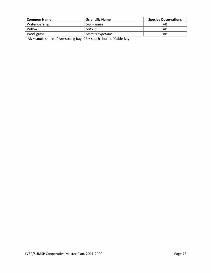
LVSP/SUMSP Cooperative Master Plan, 2011-2020 Page 76
Common Name Scientific Name Species Observations Water-parsnip Sium suave AB Willow Salix sp. AB Wool-grass Scirpus cyperinus AB
* AB = south shore of Armstrong Bay; CB = south shore of Cable Bay.
LVSP/SUMSP Cooperative Master Plan, 2011-2020 Page 77
Appendix C – Division of Forestry Management Recommendations
DNR Division of Forestry Tower Area Office 650 Highway 169 Tower, MN 55790 218-753-2580
To: Lake Vermilion and Soudan Underground Mine State Park Management Staff From: Thor Pakosz, Tower Area Forester Date: October 2010 Re: Forestry Recommendations for Lake Vermilion and Soudan Underground Mine State Parks The Division of Forestry, Tower Area Office celebrates the formation of Lake Vermilion State Park (LVSP). This document is intended to offer local insight into this important undertaking, and to demonstrate the Division’s willingness to contribute to the multi-disciplinary approach for forest management within Lake Vermilion and Soudan Underground Mine (SUMSP) state parks. While the comments here apply to both parks, we have focused our attention on LVSP due to its more recent timber management and near-term Forestry needs. Property Description Lake Vermilion State Park includes 3,034 acres of land in St. Louis County located on the eastern expanse of Lake Vermilion, northeast of Tower-Soudan and adjacent to Soudan Underground Mine State Park, which is 1,229 acres in size. While Lake Vermilion State Park was just added to the Minnesota State Parks system in June 2010, Soudan Underground Mine State Park was established in 1963. Overview The following is an elaboration of the initial needs in defining the landscape of LVSP and SUMSP. Three elements are considered: survey, planning, and applying management practices. This document offers simple reference to the various approaches the park could take when managing its land cover, and concludes with a list of practices that could be used to achieve goals specific to each forest type within the parks. Formatively, and for the next several years, the park will benefit from a systematic inventory and thorough property evaluation. Upon completion of such survey, management goals and objectives will be identified broadly for the park, and specifically to each community within. Having determined the objectives, the greatest challenge facing park administrators will be to select the management practices that best serve the parks. Finding direction for LVSP is a daunting task, yet one rich in rewards. Initially, it will be difficult to consider the many options and to make management decisions without a comprehensive property inventory and delineation of park goals. This document speaks of turning in direction of this work, as a necessary yet obvious call for such efforts.
LVSP/SUMSP Cooperative Master Plan, 2011-2020 Page 78
Property Evaluation and Inventory In development of LVSP, a thorough assessment of the plant communities, soil types, landforms, water bodies, riparian structure, wildlife, land use, and cultural resources will be relied upon in making management decisions. A significant amount of inventory has already been accomplished, yet a continued investment will reward planners handsomely. The importance of inventory in these formative years cannot be over stated. Collaboration with other DNR Divisions may aid in collecting and “truthing” the data to insure the positive outcome of inventory. Assistance from the Ecological Land Classification Program, the Minnesota County Biological Survey, and the Natural Heritage and Nongame Research Program is readily available. Contract inventory performed in October 2007 by Brian Allen, a DNR-approved Stewardship Plan writer, defines park forest types using the Minnesota DNR Cooperative Stand Assessment (CSA) Forest Inventory Classification System. Tower Area Forester Mike Magnuson, described Allen’s work as thorough, professional, and reasonable. Cover types identified within the then-proposed acquisition site included: aspen poles, aspen saplings, birch poles, cedar swamp, fir poles, fir saplings, fir timber, lowland brush, lowland hardwoods, mature aspen, pine saplings, red pine poles, red pine timber, rock outcrop, spruce bog, stagnant spruce, and wetlands. Limited forest management occurred on the property post survey, according to Mark Holien, a forester at US Steel. Documentation of the management practices carried out by US Steel is available and would be helpful with inventory and planning. US Steel has offered assistance in providing these records. A historic account of the forest, with measures of productivity and site quality, would aid in understanding the possible land cover options and help identify the management systems needed to achieve the desired outcomes. Inventory Systems Continued use of the CSA system should prove useful. The CSA vegetative inventory would provide a common language framework for communicating the direction of the park to natural resource professionals and stakeholders. Furthermore, the CSA inventory offers a picture of forest health and vigor necessary to management planning. Not only would it identify the forest community, it would also capture an assessment of forest condition. Alternatively, the park could rely on the Ecological Classification System (ECS), forgo using CSA, and choose to exclusively use the Native Plant Community (NPC) map polygons as the base resource map for management planning. This would avoid the redundancy found in using two inventory systems. The challenge in doing so, however, would be in determining how to account for growth-stage and condition class of each community. LVSP and SUMSP are found within the Northern Superior Uplands Section of the Laurentian Mixed Forest Province. Uniquely, Lake Vermilion is on the cusp of Nashwauk Uplands Subsection to the south, and Border Lakes Subsection to the north. Three Land Type Associations occur within the park: Ely Knife Lake LTA, Vermilion Bedrock Complex LTA, and Wahlsten Till Plain LTA. ECS inventory performed recently by Tavis Westbrook, Parks and Trails Resource Management Specialist, identified nine ecological systems in the park, and a diversity of NPC Classes within most systems. Working with ECS, Westbrook utilizes the most current and broadly accepted classification system employed by the DNR. John Almendinger, of the Ecological Land Classification Program, serves as the principal ECS contact with Forestry. He conditionally offers his assistance with the inventory verification work to be undertaken, and is available in coordination with the Tower Area Forestry Office.
LVSP/SUMSP Cooperative Master Plan, 2011-2020 Page 79
Planning Taking into consideration the broad range of users, park managers will balance many influences when selecting the direction for LVSP and SUMSP. Thought will be given to the desired future conditions and how the park fits broader landscape management planning. Landscape goals identified in the neighboring Subsection Forest Resource Management Plans (SFRMP) may prove helpful in this process. Developing a management plan, administrators work to determine which goals and objectives are meaningful and practical, and should be included in the plan. Goals for park management should reinforce improvements needed in the next ten years, and fluidly create a direction established for the coming one hundred years. LVSP could be envisioned with an older forest emphasis, with an objective of promoting long-lived conifer restoration. There are many sensible immediate and distant goals worthy of consideration. The park could be promoted as a canvas in display of natural resource management techniques. SFRMP landscape goals, as referenced previously, identify long-term, desired future forest composition for DNR lands within a subsection. In this planning, model forest stands are classified for treatment on a ten-year planning horizon. Considering the landscape region, and surrounding properties, LVSP/SUMSP park managers could steer a comparative course for the parks, selecting vegetative management goals consistent with the recommendations of the SFRMP planning process. Subsection Goals The parks are found on the boundary of Nashwauk Uplands and Border Lakes Subsections. SFRMP vegetative management goals for the neighboring subsections are very similar. Both plans propose the following goals for the landscape: an increase in the upland conifer forest component, the reduction in the aspen and birch component, an increase in the average stand patch size, the increase of within-stand species diversity, the protection of old-growth forest stands, the protection of Environmentally Important Lowland Conifers, and the application of practices using NPC field guides and NPC interpretations. Uniquely, the Border Lakes plan calls for retaining components of older growth stages and multi-age management, while the Nashwauk Uplands plan calls for maintenance of young forests on state lands, less balsam poplar and less balsam fir. Both plans elaborate on these goals. The Desired Future Forest Condition (DFFC) to increase the species and structural diversity of stands should serve as a worthy goal for the parks’ future. Importantly, one strategy suggested to achieve this goal is to follow Minnesota Forest Resource Council’s Site-Level Guidelines. These voluntary site-level forest management guidelines were developed by a multi-disciplinary team of resource professionals and are intended to protect the resource through the broad application of Best Management Practices (BMPs). The common use of the voluntary site-level guidelines is well rooted in Minnesota’s resource management culture. The parks should reference these guidelines. While SFRMP goals define the DFFC as an outcome, strategies are suggested as to how goals may be achieved. From one perspective, a particular goal identified in the SFRMP may not suit landscape plans for the parks; however, suggested strategies serving that goal may prove worthy of consideration for other reasons. Inventory will ultimately determine which SFRMP goals are immediately achievable within the parks. Some may better serve as distant goals. Administrators might wish to embrace the DFFC to increase acres of upland conifers through succession, conversion, and prescribed fire. Managing for Extended Rotational Forests (ERF) in riparian areas as a DFFC is an attractive, but potentially more long-term, goal considering the timber harvesting that occurred on the LVSP property in the recent past.
LVSP/SUMSP Cooperative Master Plan, 2011-2020 Page 80
Resource Management on Exhibit Park managers have an opportunity that forest managers do not have. The park can be seen as a laboratory for experimental and unconventional techniques in pursuit of many management objectives. John Almendinger writes, “I am an advocate of State Parks being a place where we can try… new things that seem impractical to the Division of Forestry, but could be accomplished in a park: pre-commercial treatments, hand control of invasives, prolonged protection and exclosures, special hunts, etc.” When at times interim practices are perceived as occurring in conflict with broader plans, it is reasonable to reference the park as a proving ground for new techniques. However, this isn’t to suggest that the park should ignore the successes of local foresters and their willingness to assist the parks in achieving their forest management goals. The Division of Forestry offers a robust skill set well exercised in vegetative management. This includes prescribed burning, planting nursery stock, aerial seeding, sanitation treatments, site preparation, and timber harvest. Other divisions should also be consulted when considering specific practices. For example, in maintaining habitat, wildlife managers are well experienced in the use of fire. LVSP and SUMSP could be defined as a recreational destination with educational opportunities in natural resource management, and environmental studies. Succession could be put on display, as might forest health topics such as Emerald Ash Borer and Dutch Elm Disease. The parks could be developed to model resource management techniques including silvicultural practices and prescribed fire. Were this pursued, themes should be developed around the parks’ infrastructure layout to optimize visitor accessibility. Fire Planning Last but certainly not least, thought needs to be given to the potential for wildland fire when planning the development of the park. Infrastructure should be designed in anticipation of the eventual occurrence of fire. Consider Firewise standards for structures and roads. Manage forest types in complement with fire protection planning. Opportunities to use fuel breaks may present themselves. Forest Management DNR Forestry employs the art and science of silviculture in promoting the establishment, growth, composition, health, and quality of forests and woodlands. What follows is a simple list of the management options specific to the forest types mapped within the park. The recommended practices and management alternatives suggested will need refinement as inventory and planning develop with increasing clarity. Here, we identify woodland improvement practices, harvest and regeneration systems, and their alternatives without recognition of management constraints under which the parks will be operating. General Impressions Not all observations of the park today are type specific. For example, one impression of the park is that it is visually less diverse than it could be. Were that true, thought should be given to management of the park viewscape. Hardwood thinning in opportune locations would break up the seeming monotony of forest age class and species composition, as might be perceived by the casual visitor to the park. The outcome would be accelerating hardwood diameter growth, while improving view of the landscape. With thinning, an under planting of long-lived, shade-tolerant, conifers would demonstrate investment in the SFRMP goal of conversion to long-lived conifers and ultimately offer the aesthetics visitors expect. Tower Forestry has regional silvicultural experience with partial shade nursing of white pine plantings under birch. Considering the advanced regeneration and mid-rotational age of the forest communities, the biomass market may be a useful tool to achieve this practice economically.
LVSP/SUMSP Cooperative Master Plan, 2011-2020 Page 81
Management techniques vary considerably, and are too numerous to mention completely. Wishing to make a contribution, Tower Forestry offers its help and expertise with silviculture and fire use. Do not hesitate to request assistance. The following management considerations are organized by the species, systems, and landforms found in the parks. Species, Systems and Landforms Aspen and Balsam Poplar. Subsection plans recommend reduction in the aspen cover type as a DFFC. Because LVSP is gifted with substantial acreage of aspen regeneration, in many age classes, it makes sense to invest in converting some of this acreage. On well-suited soils, use patch cutting as a method of conversion to pine and spruce. Additionally, consider thinning aspen types. The selective cutting of suppressed and poor-formed aspen would accelerate diameter growth in the overstory and improve the visual quality of stands. Balsam poplar is better adapted to wet soils than aspen. Paper Birch. Paper birch is prevalent in the park. Subsection plans recommend reduction in the birch cover type as a DFFC. With the objective of transitioning to Long-Lived Old Growth Conifers, the park might consider row thinning low-quality birch stands and underplanting to white pine. This practice enhances the diameter growth of the remaining birch. This would also create the partial shade, which is beneficial to the development of white pine, and accelerate the transition to long-lived Old Growth Conifers. Tower Area Forestry has employed this practice with success in the Border Lakes Subsection. On better sites, consider reserving stands for regeneration back to birch. When of merchantable age, the park might selectively harvest and patch cut birch types. Northern White Cedar. Cedar swamp is common in LVSP, especially in the northeast. Black spruce and black ash make up a secondary component. Generally, it is advisable to limit the cutting of cedar due to difficulties in regeneration. The cedar component of the park could be improved on high ground with plantings using fencing and cages as deterrents to the deer, which would otherwise browse regeneration. Avoid planting in sites which are extremely wet or dry. Balsam Fir. Manage this species with an uneven-aged silvicultural system, favoring select individuals and vigorous, well-formed groups of fir. However, discriminate against fir due to its local vulnerability to spruce budworm, and the resultant fire hazard associated with this species. Promote the pine and spruce found regenerating within fir cover types. Red Pine. Convert dry high-ground hardwoods to red pine with extended rotational forest as the goal. Intermix white pine and white spruce in plantings. Prescriptions may require protecting red pine regeneration from deer. Harvest red pine selectively to manage for ERF aesthetics. When thinning stands, remove less than one-half of the basal area, cutting smaller trees, and individuals of poor form. Generally red pine should not be cut early spring through September because of problems with bark beetles. Consider favoring white pine plantings under established red pine to avoid sirococcus shoot blight. Eastern White Pine. White pine tolerates well-drained to heavy-textured soils. It is also the pine most adaptable to shade. Pests of white pine include blister rust, weevils, and deer. Protective strategies have insured successful regeneration to this species. Convert dry high-ground hardwoods to white pine with extended rotational forest as the goal. Intermix red pine and white spruce in plantings. Jack Pine. Jack pine is not common within the park, nor is it as common on the landscape as it was historically. Wildlife managers locally promote the establishment of jack pine for its thermal cover and for other reasons. For instance, brown creeper, black backed wood peckers, and spruce grouse benefit from
LVSP/SUMSP Cooperative Master Plan, 2011-2020 Page 82
jack pine. Consider regenerating the occasional pocket of jack pine using a seed tree method. Under burn for site preparation. Where possible, convert fir stands to jack pine. Spruce. There are more stagnant spruce cover type acres than productive black spruce cover type acres in LVSP. Tamarack is a minor component of these stands. Maintenance of spruce types will involve survey for dwarf mistletoe and appropriate sanitation controls if present. Protect old growth lowland spruce as Ecologically Important Lowland Conifers. Upland spruce is a minor component in the overstory of most types. All mature spruce is subject to windthrow, especially following management. Lowland Hardwoods. Maintain ash in the park long term, using an uneven-aged regeneration system, despite the presence of Emerald Ash Borer in the state. As an educational display, interplant some American elm in ECS types where it once occurred naturally. American elm was once very common on flats and bottom lands throughout its range, but was not restricted to these sites. This native species prefers rich, moist, well-drained soil, but will adapt to many soil types, and grows best in full sun to partial shade. Reference Society of American Foresters Type 39, Black Ash-American Elm-Red Maple. Lowland Brush and Wetlands. Maintain these areas for wildlife habitat and aesthetics. These openings serve many additional ecological benefits and warrant protection. Prescribed burning is one way lowlands may be improved for wildlife. After burning, new growth is more succulent, better browse. Alternatively, some areas could be planted to trees; however, the water table may prohibit this. Riparian Communities. Riparian communities occur adjacent Lake Vermilion and inland waters. Species composition is mixed and varies. When managing, insure BMPs are used in all riparian areas. Refer to MFRC guidelines. Consider promoting late successional communities and extended rotational forest near Lake Vermilion and other waters. When possible, avoid fragmentation of shoreline aquatic habitat by limiting development to areas of transition. Rock Outcrops. Rock outcrops vary considerably within the parks, due to size, aspect, and rock type. They are known to be fragile ecological communities, with limited tree and shrub cover. Oak, Saskatoon, and wintergreen are examples of celebrated species found on these exposures. Their mast and berries attract the wildlife common to rock outcrops. Nighthawks use these areas for nesting and roosting. Woodcock use larger rock outcrops as peenting grounds. Use caution if attempting to manage types associated with these landforms.
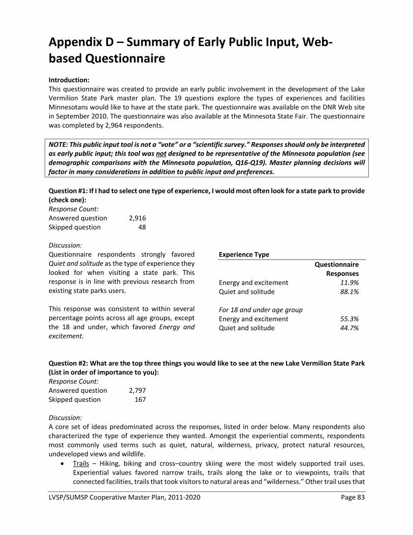
LVSP/SUMSP Cooperative Master Plan, 2011-2020 Page 83
Appendix D – Summary of Early Public Input, Web-based Questionnaire Introduction: This questionnaire was created to provide an early public involvement in the development of the Lake Vermilion State Park master plan. The 19 questions explore the types of experiences and facilities Minnesotans would like to have at the state park. The questionnaire was available on the DNR Web site in September 2010. The questionnaire was also available at the Minnesota State Fair. The questionnaire was completed by 2,964 respondents. NOTE: This public input tool is not a “vote” or a “scientific survey.” Responses should only be interpreted as early public input; this tool was not designed to be representative of the Minnesota population (see demographic comparisons with the Minnesota population, Q16-Q19). Master planning decisions will factor in many considerations in addition to public input and preferences. Question #1: If I had to select one type of experience, I would most often look for a state park to provide (check one): Response Count: Answered question 2,916 Skipped question 48 Discussion: Questionnaire respondents strongly favored Quiet and solitude as the type of experience they looked for when visiting a state park. This response is in line with previous research from existing state parks users. This response was consistent to within several percentage points across all age groups, except the 18 and under, which favored Energy and excitement.
Experience Type Questionnaire Responses Energy and excitement 11.9% Quiet and solitude 88.1% For 18 and under age group Energy and excitement 55.3% Quiet and solitude 44.7%
Question #2: What are the top three things you would like to see at the new Lake Vermilion State Park (List in order of importance to you): Response Count: Answered question 2,797 Skipped question 167 Discussion: A core set of ideas predominated across the responses, listed in order below. Many respondents also characterized the type of experience they wanted. Amongst the experiential comments, respondents most commonly used terms such as quiet, natural, wilderness, privacy, protect natural resources, undeveloped views and wildlife.
• Trails – Hiking, biking and cross–country skiing were the most widely supported trail uses. Experiential values favored narrow trails, trails along the lake or to viewpoints, trails that connected facilities, trails that took visitors to natural areas and “wilderness.” Other trail uses that
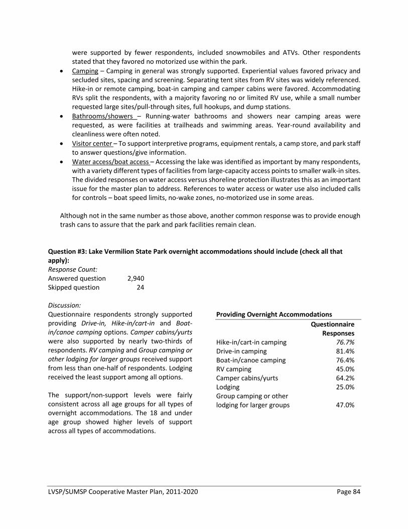
LVSP/SUMSP Cooperative Master Plan, 2011-2020 Page 84
were supported by fewer respondents, included snowmobiles and ATVs. Other respondents stated that they favored no motorized use within the park.
• Camping – Camping in general was strongly supported. Experiential values favored privacy and secluded sites, spacing and screening. Separating tent sites from RV sites was widely referenced. Hike-in or remote camping, boat-in camping and camper cabins were favored. Accommodating RVs split the respondents, with a majority favoring no or limited RV use, while a small number requested large sites/pull-through sites, full hookups, and dump stations.
• Bathrooms/showers – Running-water bathrooms and showers near camping areas were requested, as were facilities at trailheads and swimming areas. Year-round availability and cleanliness were often noted.
• Visitor center – To support interpretive programs, equipment rentals, a camp store, and park staff to answer questions/give information.
• Water access/boat access – Accessing the lake was identified as important by many respondents, with a variety different types of facilities from large-capacity access points to smaller walk-in sites. The divided responses on water access versus shoreline protection illustrates this as an important issue for the master plan to address. References to water access or water use also included calls for controls – boat speed limits, no-wake zones, no-motorized use in some areas.
Although not in the same number as those above, another common response was to provide enough trash cans to assure that the park and park facilities remain clean.
Question #3: Lake Vermilion State Park overnight accommodations should include (check all that apply): Response Count: Answered question 2,940 Skipped question 24 Discussion: Questionnaire respondents strongly supported providing Drive-in, Hike-in/cart-in and Boat-in/canoe camping options. Camper cabins/yurts were also supported by nearly two-thirds of respondents. RV camping and Group camping or other lodging for larger groups received support from less than one-half of respondents. Lodging received the least support among all options. The support/non-support levels were fairly consistent across all age groups for all types of overnight accommodations. The 18 and under age group showed higher levels of support across all types of accommodations.
Providing Overnight Accommodations Questionnaire Responses Hike-in/cart-in camping 76.7% Drive-in camping 81.4% Boat-in/canoe camping 76.4% RV camping 45.0% Camper cabins/yurts 64.2% Lodging 25.0% Group camping or other lodging for larger groups 47.0%
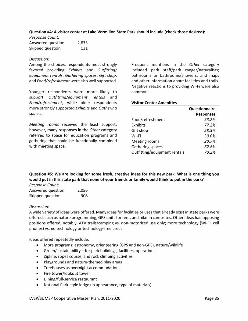
LVSP/SUMSP Cooperative Master Plan, 2011-2020 Page 85
Question #4: A visitor center at Lake Vermilion State Park should include (check those desired): Response Count: Answered question 2,833 Skipped question 131 Discussion: Among the choices, respondents most strongly favored providing Exhibits and Outfitting/ equipment rentals. Gathering spaces, Gift shop, and Food/refreshment were also well supported. Younger respondents were more likely to support Outfitting/equipment rentals and Food/refreshment, while older respondents more strongly supported Exhibits and Gathering spaces. Meeting rooms received the least support; however, many responses in the Other category referred to space for education programs and gathering that could be functionally combined with meeting space.
Frequent mentions in the Other category included park staff/park ranger/naturalists; bathrooms or bathrooms/showers; and maps and other information about facilities and trails. Negative reactions to providing Wi-Fi were also common. Visitor Center Amenities Questionnaire Responses Food/refreshment 53.2% Exhibits 77.2% Gift shop 58.3% Wi-Fi 39.0% Meeting rooms 20.7% Gathering spaces 62.8% Outfitting/equipment rentals 70.2%
Question #5: We are looking for some fresh, creative ideas for this new park. What is one thing you would put in this state park that none of your friends or family would think to put in the park? Response Count: Answered question 2,056 Skipped question 908 Discussion: A wide variety of ideas were offered. Many ideas for facilities or uses that already exist in state parks were offered, such as nature programming, GPS units for rent, and hike-in campsites. Other ideas had opposing positions offered, notably: ATV trails/camping vs. non-motorized use only; more technology (Wi-Fi, cell phones) vs. no technology or technology-free areas. Ideas offered repeatedly include:
• More programs: astronomy, orienteering (GPS and non-GPS), nature/wildlife • Green/sustainability – for park buildings, facilities, operations • Zipline, ropes course, and rock climbing activities • Playgrounds and nature-themed play areas • Treehouses as overnight accommodations • Fire tower/lookout tower • Dining/full-service restaurant • National Park-style lodge (in appearance, type of materials)
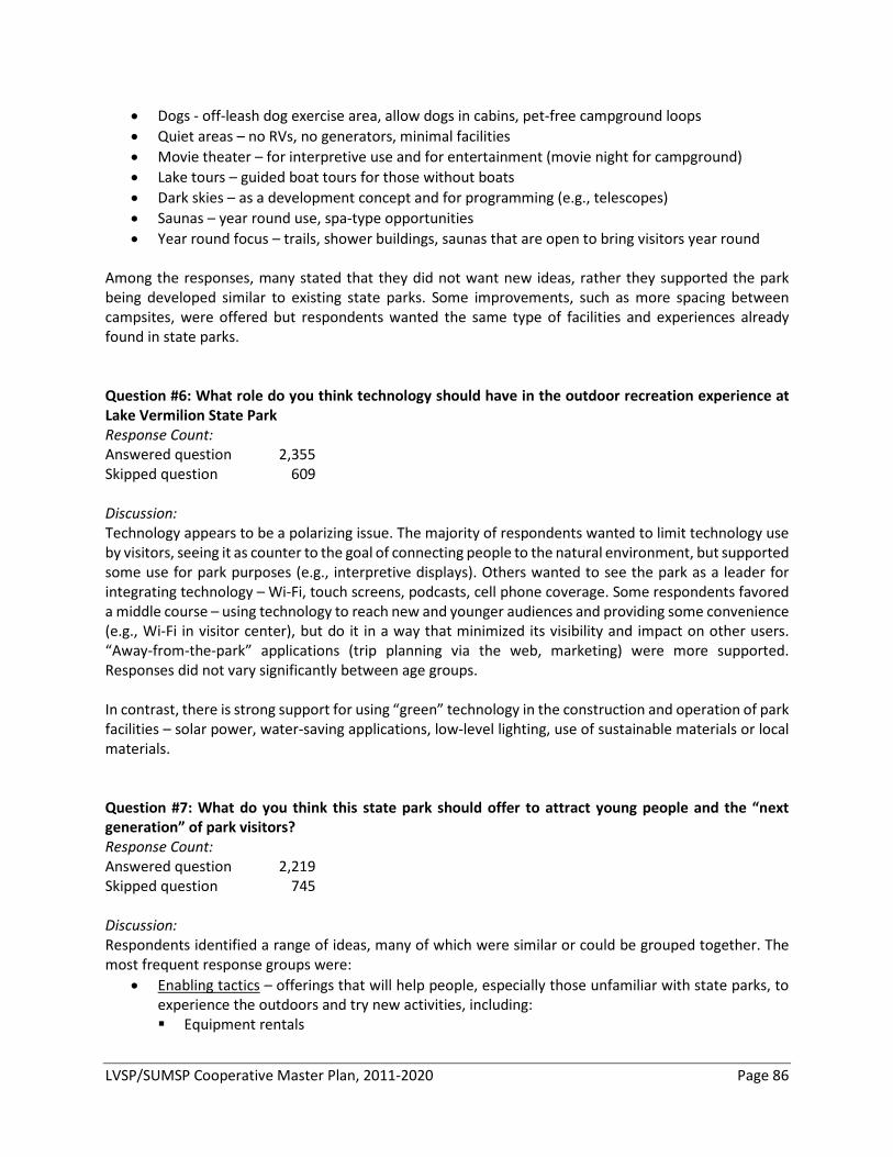
LVSP/SUMSP Cooperative Master Plan, 2011-2020 Page 86
• Dogs - off-leash dog exercise area, allow dogs in cabins, pet-free campground loops • Quiet areas – no RVs, no generators, minimal facilities • Movie theater – for interpretive use and for entertainment (movie night for campground) • Lake tours – guided boat tours for those without boats • Dark skies – as a development concept and for programming (e.g., telescopes) • Saunas – year round use, spa-type opportunities • Year round focus – trails, shower buildings, saunas that are open to bring visitors year round
Among the responses, many stated that they did not want new ideas, rather they supported the park being developed similar to existing state parks. Some improvements, such as more spacing between campsites, were offered but respondents wanted the same type of facilities and experiences already found in state parks. Question #6: What role do you think technology should have in the outdoor recreation experience at Lake Vermilion State Park Response Count: Answered question 2,355 Skipped question 609 Discussion: Technology appears to be a polarizing issue. The majority of respondents wanted to limit technology use by visitors, seeing it as counter to the goal of connecting people to the natural environment, but supported some use for park purposes (e.g., interpretive displays). Others wanted to see the park as a leader for integrating technology – Wi-Fi, touch screens, podcasts, cell phone coverage. Some respondents favored a middle course – using technology to reach new and younger audiences and providing some convenience (e.g., Wi-Fi in visitor center), but do it in a way that minimized its visibility and impact on other users. “Away-from-the-park” applications (trip planning via the web, marketing) were more supported. Responses did not vary significantly between age groups. In contrast, there is strong support for using “green” technology in the construction and operation of park facilities – solar power, water-saving applications, low-level lighting, use of sustainable materials or local materials. Question #7: What do you think this state park should offer to attract young people and the “next generation” of park visitors? Response Count: Answered question 2,219 Skipped question 745 Discussion: Respondents identified a range of ideas, many of which were similar or could be grouped together. The most frequent response groups were:
• Enabling tactics – offerings that will help people, especially those unfamiliar with state parks, to experience the outdoors and try new activities, including: Equipment rentals
LVSP/SUMSP Cooperative Master Plan, 2011-2020 Page 87
“How to” programs for skills-building Interpretive programs
• Adventure or challenge experiences – rock climbing, survival or wilderness skills programs, physical fitness challenges
• Technology – web cams, virtual tours, downloadable programs and guides • Family-friendly facilities and activities – playgrounds, junior ranger programs • Partnerships – with schools, civic groups that work with children and young adults
Many respondents did not feel that changing what state parks offers was the way to attract new users. Instead focus should be on building awareness about opportunities that already exist at state parks to get the next generation involved. This likely in part reflects the high proportion of questionnaire respondents that are current state park visitors (see Question #18). Question #8: Is there anything that might be included in this park that would make you less likely to visit? Response Count: Answered question 2,258 Skipped question 706 Discussion: Several consistent themes carried through responses about what would make people less likely to visit Lake Vermilion State Park:
• Motorized use - especially ATVs, was the most identified detractor. ATVs were the single most noted detractor. Other motorized uses – OHV, motorbikes, and snowmobiles where included in many of the responses. This also extended to motorized watercraft – jets skis particularly, but also large/fast/loud boats.
• RVs - were the second-most identified. Noise, generators, lights, size of unit/size of site needed to accommodate unit were all listed as why RVs are a detractor.
• Campsite design and operation – many issues related to camping experiences were identified such as mixing RVs and tents, not enough spacing, not enough privacy, no shade or screening, too much noise, too crowded/campground too large.
• Noise – as a general detractor in a wide range of situations: from motorized use, in campgrounds, from RVs, from large crowds.
• Too commercial - too much emphasis on making revenue or selling products –either vendors or the state itself.
• Too much development – respondents preferred a more natural park experience, with less developed infrastructure, fewer buildings, smaller development footprints. This response is often related to “commercialization.”
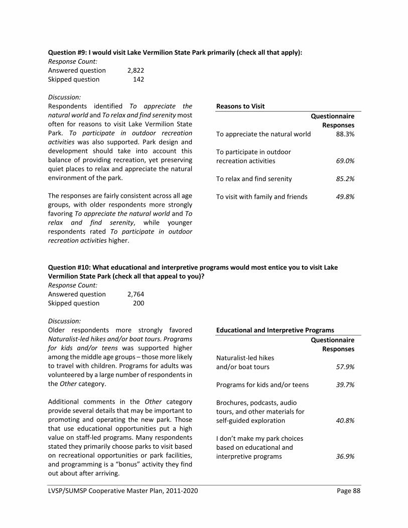
LVSP/SUMSP Cooperative Master Plan, 2011-2020 Page 88
Question #9: I would visit Lake Vermilion State Park primarily (check all that apply): Response Count: Answered question 2,822 Skipped question 142 Discussion: Respondents identified To appreciate the natural world and To relax and find serenity most often for reasons to visit Lake Vermilion State Park. To participate in outdoor recreation activities was also supported. Park design and development should take into account this balance of providing recreation, yet preserving quiet places to relax and appreciate the natural environment of the park. The responses are fairly consistent across all age groups, with older respondents more strongly favoring To appreciate the natural world and To relax and find serenity, while younger respondents rated To participate in outdoor recreation activities higher.
Reasons to Visit Questionnaire Responses To appreciate the natural world 88.3% To participate in outdoor recreation activities 69.0% To relax and find serenity 85.2% To visit with family and friends 49.8%
Question #10: What educational and interpretive programs would most entice you to visit Lake Vermilion State Park (check all that appeal to you)? Response Count: Answered question 2,764 Skipped question 200 Discussion:Older respondents more strongly favored Naturalist-led hikes and/or boat tours. Programs for kids and/or teens was supported higher among the middle age groups – those more likely to travel with children. Programs for adults was volunteered by a large number of respondents in the Other category. Additional comments in the Other category provide several details that may be important to promoting and operating the new park. Those that use educational opportunities put a high value on staff-led programs. Many respondents stated they primarily choose parks to visit based on recreational opportunities or park facilities, and programming is a “bonus” activity they find out about after arriving.
Educational and Interpretive Programs Questionnaire Responses Naturalist-led hikes and/or boat tours 57.9% Programs for kids and/or teens 39.7% Brochures, podcasts, audio tours, and other materials for self-guided exploration 40.8% I don’t make my park choices based on educational and interpretive programs 36.9%
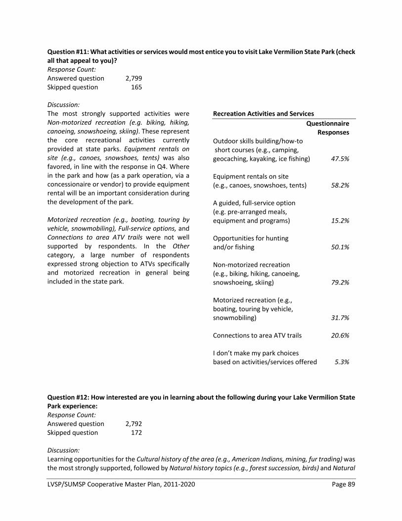
LVSP/SUMSP Cooperative Master Plan, 2011-2020 Page 89
Question #11: What activities or services would most entice you to visit Lake Vermilion State Park (check all that appeal to you)? Response Count: Answered question 2,799 Skipped question 165 Discussion: The most strongly supported activities were Non-motorized recreation (e.g. biking, hiking, canoeing, snowshoeing, skiing). These represent the core recreational activities currently provided at state parks. Equipment rentals on site (e.g., canoes, snowshoes, tents) was also favored, in line with the response in Q4. Where in the park and how (as a park operation, via a concessionaire or vendor) to provide equipment rental will be an important consideration during the development of the park. Motorized recreation (e.g., boating, touring by vehicle, snowmobiling), Full-service options, and Connections to area ATV trails were not well supported by respondents. In the Other category, a large number of respondents expressed strong objection to ATVs specifically and motorized recreation in general being included in the state park.
Recreation Activities and Services Questionnaire Responses Outdoor skills building/how-to short courses (e.g., camping, geocaching, kayaking, ice fishing) 47.5% Equipment rentals on site (e.g., canoes, snowshoes, tents) 58.2% A guided, full-service option (e.g. pre-arranged meals, equipment and programs) 15.2% Opportunities for hunting and/or fishing 50.1% Non-motorized recreation (e.g., biking, hiking, canoeing, snowshoeing, skiing) 79.2% Motorized recreation (e.g., boating, touring by vehicle, snowmobiling) 31.7% Connections to area ATV trails 20.6% I don’t make my park choices based on activities/services offered 5.3%
Question #12: How interested are you in learning about the following during your Lake Vermilion State Park experience: Response Count: Answered question 2,792 Skipped question 172 Discussion: Learning opportunities for the Cultural history of the area (e.g., American Indians, mining, fur trading) was the most strongly supported, followed by Natural history topics (e.g., forest succession, birds) and Natural
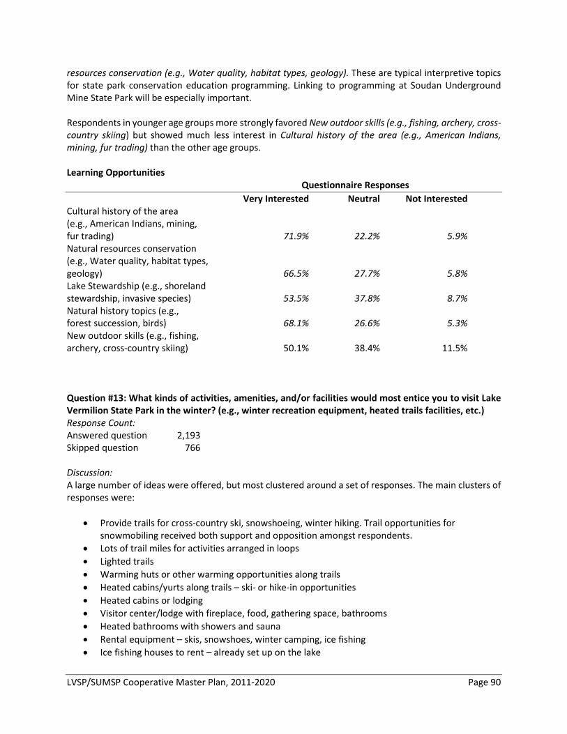
LVSP/SUMSP Cooperative Master Plan, 2011-2020 Page 90
resources conservation (e.g., Water quality, habitat types, geology). These are typical interpretive topics for state park conservation education programming. Linking to programming at Soudan Underground Mine State Park will be especially important. Respondents in younger age groups more strongly favored New outdoor skills (e.g., fishing, archery, cross-country skiing) but showed much less interest in Cultural history of the area (e.g., American Indians, mining, fur trading) than the other age groups. Learning Opportunities Questionnaire Responses Very Interested Neutral Not Interested Cultural history of the area (e.g., American Indians, mining, fur trading) 71.9% 22.2% 5.9% Natural resources conservation (e.g., Water quality, habitat types, geology) 66.5% 27.7% 5.8% Lake Stewardship (e.g., shoreland stewardship, invasive species) 53.5% 37.8% 8.7% Natural history topics (e.g., forest succession, birds) 68.1% 26.6% 5.3% New outdoor skills (e.g., fishing, archery, cross-country skiing) 50.1% 38.4% 11.5%
Question #13: What kinds of activities, amenities, and/or facilities would most entice you to visit Lake Vermilion State Park in the winter? (e.g., winter recreation equipment, heated trails facilities, etc.) Response Count: Answered question 2,193 Skipped question 766 Discussion: A large number of ideas were offered, but most clustered around a set of responses. The main clusters of responses were:
• Provide trails for cross-country ski, snowshoeing, winter hiking. Trail opportunities for snowmobiling received both support and opposition amongst respondents.
• Lots of trail miles for activities arranged in loops • Lighted trails • Warming huts or other warming opportunities along trails • Heated cabins/yurts along trails – ski- or hike-in opportunities • Heated cabins or lodging • Visitor center/lodge with fireplace, food, gathering space, bathrooms • Heated bathrooms with showers and sauna • Rental equipment – skis, snowshoes, winter camping, ice fishing • Ice fishing houses to rent – already set up on the lake

LVSP/SUMSP Cooperative Master Plan, 2011-2020 Page 91
• Skills building/guided experiences – snowshoe, ski, winter camping, ice fishing Experiential-related comments focused on relaxation, peacefulness, absence of noise, and fewer people.
Question #14: If you would likely bring children and teens to the park, what kinds of facilities and activities would you like to see provided? (Skip to Question 15 if you would not likely bring children/teens) Response Count: Answered question 1,075 Skipped question 1,889 Discussion: Approximately one-third of respondents answered they would likely bring children or teens to the park. Suggestions for facilities and activities clustered around several areas:
Children • Naturalist-led education programs –
hands-on programs on wildlife, arts and crafts, basic skills
• Playground/free-play areas • Hiking and biking trails • Swimming area • Fishing opportunities • Kid-friendly bathrooms • Camping opportunities
Teens • Skills-building programs on more
advanced topics • Challenge activities – zip line, ropes
course, rock climbing • Rental equipment to try new things, part
of challenge activities • Hiking and biking trails • Swimming area • Places to hang out • Programs just for teens (without
parents) Respondents for teen opportunities demonstrated a push-pull on technology. Many strongly resist the presence of technology and want the park to be a place where teens “unplug” for their experiences. Others wanted to use technology to connect teens to the outdoors (e.g., geocaching, audio tours, interactive displays). Question #15: Which other activities, destinations or attractions might you also explore during your trip to Lake Vermilion State Park?
Response Count: Answered question 1,650 Skipped question 1,314 Discussion: Approximately two-thirds of respondents provided information on other activities, destinations, or attractions they may visit. Responses included specific references to an attraction or location and more general ideas of activities:
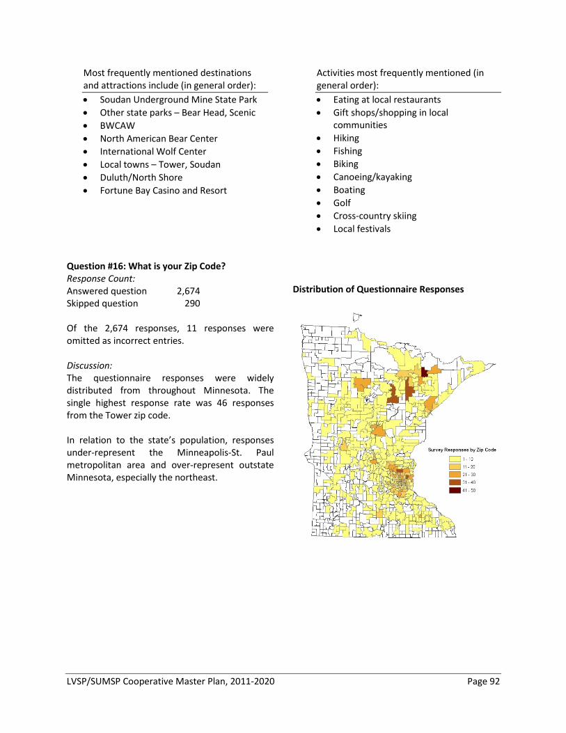
LVSP/SUMSP Cooperative Master Plan, 2011-2020 Page 92
Most frequently mentioned destinations and attractions include (in general order): • Soudan Underground Mine State Park • Other state parks – Bear Head, Scenic • BWCAW • North American Bear Center • International Wolf Center • Local towns – Tower, Soudan • Duluth/North Shore • Fortune Bay Casino and Resort
Activities most frequently mentioned (in general order): • Eating at local restaurants • Gift shops/shopping in local
communities • Hiking • Fishing • Biking • Canoeing/kayaking • Boating • Golf • Cross-country skiing • Local festivals
Question #16: What is your Zip Code? Response Count: Answered question 2,674 Skipped question 290 Of the 2,674 responses, 11 responses were omitted as incorrect entries. Discussion: The questionnaire responses were widely distributed from throughout Minnesota. The single highest response rate was 46 responses from the Tower zip code. In relation to the state’s population, responses under-represent the Minneapolis-St. Paul metropolitan area and over-represent outstate Minnesota, especially the northeast.
Distribution of Questionnaire Responses
LVSP/SUMSP Cooperative Master Plan, 2011-2020 Page 93
Question #17: How old are you? Response Count: Answered questions 2,801 Skipped questions 163 Discussion: Questionnaire respondents are skewed toward older age groups in comparison to the state’s population, and when compared to state park visitors. The youngest age groups – children, teens and young adults - are significantly under-represented in the questionnaire responses. Data from the most recent state park visitor studies also show the pattern of more visitors among older Minnesotans in comparison to the state’s population, but to a lesser extent than the questionnaire respondents. (Note: Age groups for the state park visits and questionnaire are not the same.) The small number of respondents in the two youngest age groups means caution should be used when comparing across groups.
Age Comparisons Questionnaire MN pop Responses (’09) 18 and under 1.7% 25.3% 19 – 25 3.2% 10.0% 26 – 40 24.5% 19.6% 41 – 65 62.3% 33.1% Over 65 8.3% 11.9% State Park MN pop Visitors (’07) (’06) 18 and under 29% 28% 19 – 34 12% 22% 35 – 44 17% 15% 45 – 64 35% 25% Over 65 7% 12%
Question #18: How often do you visit State Parks? Response Count: Answered questions 2,802 Skipped questions 162 Discussion: The questionnaire respondents are overwhelmingly current visitors to state parks – more than 83% answering A few times per year or Once per month or more. In comparison, the 2007 state park studies found that 30% of Minnesotans visit a state park in a given year.
State Park Visitation Questionnaire Responses Once per month or more 23.3% A few times a year 59.9% Occasionally (once/year or less) 16.0% Never 0.9%
LVSP/SUMSP Cooperative Master Plan, 2011-2020 Page 94
Question #19: When you visit Lake Vermilion State Park will you likely visit: (select one) Response Count: Answered questions 2,797 Skipped questions 167 Discussion: Questionnaire respondents are most likely to visit Lake Vermilion State Park With immediate family or With a small group of family/friends. These answers are in line with existing visitation patterns for state parks. The majority of park visitors are family groups. However, for 18 and under and 19-25 age groups, With a small group of family/friends replaces With immediate family as the most common response. The low response for With larger group of family/friends should not be characterized as to not support the need for group gathering spaces or group camping. “Small” was not defined, and some of these groups will likely use group facilities.
Visitation Group Size Questionnaire Responses By yourself 3.0% With immediate family 55.0% With a small group of family/friends 39.4% With a large group of family/friends 2.6% For 18 and under age group With immediate family 39.1% With a small group of family/friends 45.7% For 19-25 age group With immediate family 34.1% With a small group of family/friends 58.0%
LVSP/SUMSP Cooperative Master Plan, 2011-2020 Page 95
Appendix E – Citizens Advisory Committee (CAC) Recommendations
Citizen Advisory Committee Lake Vermilion State Park
[November 17, 2010]
MEMBERSHIP: The DNR Commissioner established a Citizens Advisory Committee (CAC) to provide guidance to the Department during the writing of the Lake Vermilion State Park master plan. The CAC members were selected to assure local, regional and statewide perspectives were represented as part of the committee. Nineteen individuals served as members of the Citizens Advisory Committee:
• Steve Abrahamson, Mayor of Tower, MN • Andrew Brantingham, Board Member, Parks and Trails Council of Minnesota • Tim Campbell, NE Regional Manager, Explore MN Tourism • Skip Drake, Northern Sites District Manager, MN Historical Society • Ken Gilbertson, Director/Professor, UMD Center for Environmental Education • Mel Hintz, President, Sportsmen's Club of Lake Vermilion • Nancy Hanson, Executive Director, MN United Snowmobilers Association / Member, Minnesota
Recreational Trail Users Association • Bob Krepps, St. Louis County Land Commissioner • Nancy Larson, Community planning consultant; Stuntz Bay Boathouse Association member • Mark Ludlow, Realtor and Owner, Ludlow Island Resort • Bob Manzoline, Executive Director, Regional Railroad Authority (Mesabi Trail) • Shawn Murphy, Executive Director, Lake Vermilion Park Society • Jay Schelde, Owner, Pike View Lodge / Lake Vermilion Resort Association • Dave Simpkins, Editor/Publisher, Minnesota Trails Magazine • Mary Somnis, Community Development Representative, Iron Range Resources • Bill Latady, Bois Forte Cultural Resources Director • Tim Tomsich, Breitung Township Supervisor • Hannah Tuntland, Vermilion Community College student • Karen Umphress, Project Coordinator, National Off-Highway Vehicle Conservation Coalition
LVSP/SUMSP Cooperative Master Plan, 2011-2020 Page 96
CITIZEN ADVISORY COMMITTEE TASKS AND PROCESS: The charge to the CAC was to make recommendations to the DNR commissioner, who is the ultimate decision maker with respect to the content in the master plan. In addition to the main CAC, subcommittees were also formed with additional non-CAC members to assist in developing recommendations. The general public was welcome to observe CAC meetings and provide oral public comments to the committee at the close of each meeting. The CAC met seven times during the master plan process:
June 30, 2010 - Tower Civic Center July 28, 2010 - Tower Civic Center August 25, 2010 – DNR Central Office, St. Paul September 29, 2010 - Tower Civic Center October 27, 2010 - Tower Civic Center November 17, 2010 - Tower Civic Center
CAC RECOMMENDATIONS – DIRECTIONAL STATEMENTS: The CAC created recommendations for the DNR Commissioner in the form of Directional Statements. These Directional Statements were the outcome of work by the CAC subcommittees, which was reported to and edited by the CAC as a whole. The Directional Statements are organized in topic areas: Visitor Experiences, Interpretation and Education, Natural and Cultural Resources, and Infrastructure. The workgroups and CAC also created rationale for many of the directional statements – short descriptions that provide further context and detail of the committee’s intent. The CAC Directional Statements and rationale provided guidance to DNR staff during the development of the draft master plan. Visitor Experiences
1. The park should offer plenty of camper cabins and yurts. The park should work with local resort association to insure that the park overnight opportunities are complementary with experiences offered by resorts.
2. The park should offer some primitive camping opportunities (e.g., remote, single-site, boat-up or
hike-in opportunities) as part of the range of camping options at the park.
3. A clustered, family-friendly, full-service campground should be located within a reasonable walking distance of the lake, but should not be visible from the lake. The campground should cluster like kinds of use in order to minimize user conflicts. Smaller, non-electric sites should be located closer to the lake; electric and larger RV sites should be located further away from the lake in a separate location.
4. The park should offer upgraded group camping opportunities (with a higher level amenities).
5. The park should offer a separate campground for ATVs with connections to area trails. The park
should investigate the demand for year-round use of the campground by ATVs or snowmobiles.
6. Whenever possible separate the vehicles from the camping and centralize the parking in clusters.
LVSP/SUMSP Cooperative Master Plan, 2011-2020 Page 97
7. The Visitor Center should also serve as the trail center for both warm- and cold-season activities. The center should be a mix of modern and up-north design, and include 1) outdoor gathering spaces (amphitheater and outdoor fireplaces), 2) interpretive spaces; 3) local contract vendor for food service; 4) equipment rentals; 5) a hub for trail activities; and 6) boat access from the lake; and 7) indoor classroom/meeting space.
8. Build a contact station on Hwy 169 that will include 1) registration station, 2) invasive species
inspection and cleaning area, 3) general area/park information, 4) park office (for Soudan and Vermilion) and 5) public restrooms.
9. The Visitor Center should embrace Wi-Fi and other technologies to make “being away” easier.
10. The Visitor Center should have a museum or interpretive displays for mining, fur trading,
American Indians and/or natural resources conservation.
11. The Visitor Center should have a gift shop, outfitting service, equipment rentals, and meeting rooms.
12. The park should primarily focus on the following three kinds of trails:
1) Hiking/Cross-country skiing (traditional and skate)/Snowshoeing 2) Biking 3) Snowmobiling
13. The park should be a model for sustainability.
14. Some of the overlook peaks at the park should be made accessible, but some exceptions should be made if doing so will severely diminish the character of the site.
15. The park should provide overnight and day use opportunities for groups:
Overnight – a) pods/loops within the campground that allow groups to be together b) designated group camp
Day use – a) areas within a picnic area for reservation/use by groups b) a gathering area near the visitor center
16. The park should be a national leader by requiring visitors to clean boats, vehicles and equipment
before entering and leaving the park.
17. DNR should obtain ownership of the BLM islands in the vicinity of the park.
18. Create public-private partnerships for things like trail maintenance, interpretive programming, and rental/food concessions.
LVSP/SUMSP Cooperative Master Plan, 2011-2020 Page 98
Interpretation and Education 1. While traditional users should not be ignored in interpretive efforts, the inexperienced
park/outdoor user should be the primary audience for interpretation. A subset of this group would include schools/youth. A secondary audience, aside from the school/youth, should be the regional (permanent, seasonal, and temporary) residents.
2. The park offers the opportunity to interpret a wide variety of thematic areas; however, the themes that fit best with the primary audiences are listed below. Regardless what theme is chosen, it must allow visitors to think creatively and critically and to constantly use their imagination.
a. Creating a sense of place and comfort in our natural environment, which can be accomplished by teaching outdoor skills, such as, how to camp, how to canoe, how to geocache, how to build a fire, how to fish, how to snowshoe, etc. – skills that will enable the individuals to better enjoy/feel comfortable in the outdoors.
b. Crossing boundaries – this will explore how this area relates to other areas, regions, biomes, or nations. It will include a focus of cultural history (mining, Native American, fur trading, current management of resources, etc.) and natural history (geology, flora, and fauna, especially the boreal forest habitat).
c. Scientific discovery – there are many “true” scientific experiments occurring at the park, including water quality testing, physics experiments, bacteria research, and bat research. There are also opportunities for citizen science projects relating to these and other research projects. We need to encourage self-directed enquiry in addition to the true research projects.
3. There are a variety of interpretive approaches to present information to the park visitor. To
accomplish this effectively, however, the park needs to incorporate the following: a. Different methodologies must be used to appeal to a wider audience – there must be
variety with tried and true approaches (exhibit displays, guided tours, kiosks, etc.), combined with cutting edge approaches (touch screen displays, smart phones, video conferencing, etc). An emphasis should be placed on approaches that involve audio programming, such as mp3 audio tours.
b. Guided interpretation and skill development need to be integrated into the programming. c. There needs to be flexibility so the selection of an exhibit/display or an electronic
approach enhances the interpretive message. d. Interactive web-based approaches need to be cultivated.
4. Programming should be conducted from a variety of locations at the park, including visitor
centers, trail centers, access points, etc. One main visitor center for all interpretation is not practical. It will be crucial to the success of Soudan Underground Mine State Park to have a new visitor center that meets the needs of its clients. There also needs to be flexibility to offer interpretation on the park web pages and at a variety of off-site locations.
5. There are a variety of partners that the DNR should utilize for its interpretive programming, whether it is as a program and activity advisory group or to serve as an interpretive resource. The most important aspect should focus on the park being a role model for other organizations in how it conducts its partnerships. The major partners should include the following:
LVSP/SUMSP Cooperative Master Plan, 2011-2020 Page 99
a. Local community, including the local charter school, resorts, local government entities, community organizations/members, and professionals in the field.
b. Bois Forte Band c. School – area schools and schools throughout the state d. Various non-profit organizations/state organizations, including area colleges/universities,
historical societies, USFS, MN Master Naturalists, etc.
Natural and Cultural Resources Natural Resource Directional Statements
1. Protect endangered, threatened, rare, and/or significant plant and animal species, and unique geologic features.
2. Maintain, enhance, or restore a variety of healthy natural communities, especially uncommon forest types or components. • Preserve the dry open woodlands with thin soils, rock outcrops, cliffs, and talus slope features. • Preserve the beaver wetland complexes. • Preserve the mesic hardwood forests. • Encourage the development and maintenance of older forests • Prevent the introduction, establishment, and spread of terrestrial and aquatic invasive plants. • Be willing to employ a variety of forest management techniques including prescribed fire,
logging, and non-commercial thinning or release, planting, scarification and seeding provided they help meet management objectives.
3. Preserve or enhance the parks’ water resources and aquatic systems.
• Preserve the parks’ open and forested wetlands and peatlands. • Maintain the integrity of the parks’ undeveloped shoreline and near-shore habitats. • Employ strategies to minimize phosphorus inputs.
4. Maintain high use areas like campgrounds, picnic areas and heavily used trails so that natural and
cultural resource degradation is minimized while visitor safety and enjoyment are enhanced.
5. Manage wildlife populations for ecological sustainability. • Manage white-tailed deer populations such that native vegetation and tree regeneration are
not negatively impacted. • Monitor other wildlife populations, and if needed, create and implement management
strategies to maintain ecosystem sustainability. • Maintain healthy, stable bat populations at the mine.
6. Work with the Bois Forte community to identify and manage the continued traditional use harvest
or collection areas and plant populations.
7. Protect Lake Vermilion State Park’s scenic and aesthetic qualities so that evidence of human influences are minimized. • Site new development so that it is not visible from long distances, including views from Lake
Vermilion. • Protect northern lights, night-sky aesthetic by minimizing light pollution from parks.
LVSP/SUMSP Cooperative Master Plan, 2011-2020 Page 100
• Design boardwalks and overlooks to minimize their visual impact when seen from Lake Vermilion and other vantage points.
• Keep certain pits and stockpile areas in Soudan Underground Mine free of vegetation so as to maintain the mine site’s industrial characteristics.
8. Develop natural resource research, monitoring, and outreach programs.
• Continue to expand the natural resource inventories in the park. • Use interpretation and outreach to more effectively promote understanding and awareness
of natural and cultural resources within the park. • Explore ways to involve a variety of people in the resource management work at the park.
Cultural Resource Directional Statements
1. Inventory and evaluate cultural resources in SUMSP and LVSP and record the resources within the cultural resource geodatabase, part of the overall Geographic Information System.
2. Integrate results of cultural resource studies into interpretive programming at SUMSP and LVSP.
3. Investigate revising the Soudan Mine National Historic Landmark nomination and boundary.
4. Review management of the Stuntz Bay Boathouse Historic District.
5. Develop a cultural resource management plan to facilitate the preservation and management of cultural resources within SUMSP and LVSP.
6. Balance the desire for maintaining the historic integrity of the Soudan Mine NHL with modernizing
and making buildings and equipment efficient, safe and code compliant.
7. Preserve the historic integrity of the underground areas at the site.
8. Conduct cultural resource reviews for new development proposals and resource management activities.
9. Prioritize park areas for vegetative removal to maintain the mine site’s industrial characteristics.
10. Follow the Division of Parks and Recreation’s Collections Policy protocol.
11. Inform local communities, mining companies, and equipment distributors of the Division
Collections Policy.
12. Work with the Bois Forte Band of Chippewa and the local communities to promote the protection and interpretation of cultural resources outside of the park boundaries.
LVSP/SUMSP Cooperative Master Plan, 2011-2020 Page 101
Infrastructure 1. Water, sewer, utilities and any other type of infrastructure should be designed in a sustainable
manner and situated in such a way that they have the least impact on the parks’ natural and cultural resources.
2. The Jasper Peak intersection should be given primary consideration for the main park entrance
location. If this location is not feasible, the Murray Forest Road location should be considered next.
3. A connection to Soudan Underground Mine State Park should be provided from the Lake
Vermilion State Park.
4. A tunnel access under Hwy 169 should be pursued for access to the southern LVSP unit.
5. The main park road should be a wishbone with a natural surfaced, accessible trail connecting east and west sides. Lake views should be incorporated where possible, as well as spur trails to lakeside campsites and day-use areas (observation areas). Paving this connector trail should be evaluated in the future.
6. The park visitor center should be located near the lake, preferably near the statutory boundary
that separates the two parks. Reasonable access should be provided.
7. The park should develop a new boat access in close proximity to camping facilities. The Stuntz Bay access should remain available for general public water access. If necessary, an alternative access on Stuntz Bay should be pursued.
8. The Mesabi Trail should be provided an alignment along the old Ely Road to cross Lake Vermilion
State Park.
LVSP/SUMSP Cooperative Master Plan, 2011-2020 Page 102
Appendix F – Summary of Comments from 30-Day Public Review Minnesota Statutes, section 86A.09, subd. 2 requires master plans be made available for at 30-day public review prior to submitting the plan to the Commissioner of Natural Resources. The public comment period for this Cooperative Master Plan began November 22 and ended December 22, 2010. As part of the public review, two open houses were held—on December 7, 2010 at Silverwood Park in Fridley, Minnesota and on December 9, 2010 at the Tower Civic Center in Tower, Minnesota.
During the public review period, public comments were received three ways.
Online public input form – An online comment form was posted on the DNR website along with the draft master plan. The form included five questions to help categorize responses from the public. When the public comment period closed on December 22, 59 comments had been received.
Open house comment forms – Comment forms were distributed at both open houses. These forms had the same five questions as the online public input form. Four completed forms were received at the Tower meeting. No completed forms were collected at the Silverwood Park meeting. One additional comment form was received via the mail following the meetings. Many comments were made verbally at both meetings. The most frequent topic was about cross-country ski opportunities—a desire to see ski trails open for the winter of 2010-11, just as snowmobile trails were open.
Email comments – Comments about the master plan were also received via email. Twenty-four comments were received during the 30-day public review period; 92 comments were received during the planning process, before the 30-day public review period (June through November 2010).
Public comment summary – The main messages included the following:
1) Respondents generally approved of the plan as it was written, or desired some amendments in the descriptions of proposed uses and amenities. Many of these comments will provide useful guidance to DNR as we move into the design phase for campgrounds, facilities, roads and trails. Where possible, amendments and clarifications were made to the master plan to reflect these concerns.
2) The main concern raised was a challenge DNR faces in all of our parks: mitigating conflicts with different types of use. Primarily, the suggestions were to minimize and mitigate noise from those seeking a quiet experience by separating different kinds of use, especially motorized and non-motorized (e.g., RVs/tents; motorboats/paddlesports; skiing/ snowmobiling/ snowshoeing). The concept plan for the park does attempt to provide a suite of recreational and overnight opportunities, and has suggested geographic separation of uses that may be in conflict with one another (see VS4.1, for example).
3) Invasive species continue to be a concern—particularly aquatic invasive species and seeds from terrestrial invasives that may enter the park via construction equipment, outdoor recreation equipment (e.g., campers, bikes, boats), vehicles and motorized recreation. DNR has addressed this concern in three master plan recommendations (NR3.5, VS1.5, VS2.2) and with the DNR Operational Order #113—and its associated discipline-specific guidelines. Op
LVSP/SUMSP Cooperative Master Plan, 2011-2020 Page 103
Order #113 and discipline guidelines on invasive species address: 1) All activities DNR staff conduct; 2) All activities DNR contracts to have done; 3) Bonding of resource management and construction activities; 4) Permitted activities, e.g., research permits, geocache permits, special events; and 5) What visitors do when they are recreating on state lands (permitted activity).
4) Many comments advocated the addition of horseback riding trails and horse camp opportunities within the parks (22 different people commented via email and/or the web-based public input tool). Early discussions about adding horseback trails and dogsledding/skijoring opportunities occurred within the Department and with the Citizens Advisory Committee. However, the discussions were curtailed due to the lack of connectivity between potential opportunities the parks might offer and other area opportunities. In other words, the sentiment was that the abundance of wetlands, thin soils and old-growth stands within the park properties would limit the number of miles of trails feasible—so connections to other trails outside of the park would be necessary. Further consideration will be given to horseback and dogsledding/skijoring opportunities during development of the parks’ cooperative road and trails system plan (RU1.1).
5) Comments opposing use of off-highway vehicles and snowmobiles within the state park also appeared with some frequency (11 comments). At this point, the master plan is considering allowing OHVs only within the trails-oriented campground south of State Highway 169. The DNR is committed to developing these parks’ as a recreational hub for this part of the state and will explore opportunities for family-oriented trail riding in the Bear Island State Forest (BISF), if a safe and sustainable route can be established between the trailside campground and the forest’s riding opportunities (RU2.3 and VS4.2). Recreational trails developed within the parks, however, will focus on hiking, biking, snowshoeing, cross-country skiing and snowmobiling (RU1.2).
A complete list of the public comments and DNR responses is available upon request.