Embed Size (px)
Citation preview
Maritime Archaeology Monographs and Reports Series
No.7
Convict probation and the evolution of jetties at Cascades, the Coal Mines, Impression Bay and Saltwater River, Tasman Peninsula, Tasmania
An historical perspective
By Rick Bullers
Department of Archaeology Flinders University
South Australia 2005

ii
Maritime Archaeology Monographs and Reports Series
No.7
Convict probation and the evolution of jetties at Cascades, the Coal Mines, Impression Bay and Saltwater River, Tasman Peninsula, Tasmania
An historical perspective
By Rick Bullers
Department of Archaeology Flinders University
South Australia 2005
iii
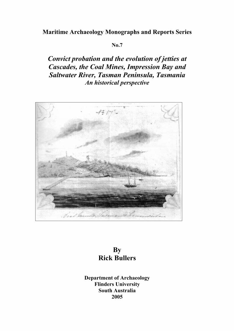
ISSN 1832-3545 First published in 2005 by the Department of Archaeology c/o Flinders University GPO Box 2100 Adelaide, South Australia, 5001 Copyright © the author 2005 All rights reserved. This monograph series is copyright apart from any fair dealings for the purposes of private study, research, criticism or review, as permitted under the Copyright Act, no part may be reproduced without written permission. Enquiries should be addressed to the publisher. Front cover illustration: DGA64, Thomas Lempriere ‘Coal Mines Tasman’s Peninsula,’ c.1840-41, Dixon Library, NSW. Printed and bound by Flinders Press Fifty copies of this document were printed at a cost of $6.14 per copy.
iv
Published Monographs and Reports in the Maritime Archaeology Monographs and Reports Series
1. Julie Ford The Archaeology of Aircraft Losses in water in Victoria, Australia during World War Two (Master of Maritime Archaeology Thesis, 2004)
2. Mike Nash Investigation of a Survivors Camp from the Sydney Cove
Shipwreck (Master of Maritime Archaeology Thesis, 2004) 3. Adam Paterson Understanding the Sleaford Bay Tryworks: An Interpretive
Approach to the Industrial Archaeology of Shore Based Whaling (Master of Maritime Archaeology Thesis, 2004)
4. Aidan Ash A Nice Place for a Harbour or is it? Investigating a maritime
cultural landscape: Port Willunga, South Australia (Honours Thesis, 2004)
5. Rebecca O’Reilly An Assessment of Australian Built Wooden Sailing Vessels (constructed between 1850-1899) operating in the South Australian Intrastate Trade (Honours Thesis, 1999)
6. Mark Staniforth The History and Archaeology of the Gaultois Shore-Based
Whaling Station in Newfoundland, Canada and
Martin Mc Gonigle and Mark Staniforth Historical Background and Archaeological Survey of Balaena, A 20th Century Norwegian Whaling Station in Newfoundland, Canada (Interim Reports, 2003)
7. Rick Bullers Convict probation and the evolution of jetties at Cascades, the
Coal Mines, Impression Bay and Saltwater River, Tasman Peninsula, Tasmania. An historical perspective (Research Report, 2005)
v
Maritime Archaeology Monographs and Reports Series
Maritime archaeology has been taught at undergraduate level in the Department of Archaeology at Flinders University since 1996 and the first Bachelor of Arts Honours thesis in maritime archaeology was completed in 1997. The introduction of the Bachelor of Archaeology in 1997 saw undergraduate students specializing in maritime archaeology for the first time and the first Bachelor of Archaeology Honours thesis appeared in 1999. Then in 2002, a new Graduate Program in Maritime Archaeology was introduced resulting in the first Master of Maritime Archaeology thesis in 2003. Since 1997 a significant number of research theses and reports have been completed by staff and students in underwater and maritime archaeology. The Honours and Master of Maritime Archaeology theses are required to be approximately 15,000 to 18,000 words and therefore are rarely, if ever, published in full. As a result much of this valuable research remains essentially unpublished and difficult to access - a part of the "grey literature". The Department of Archaeology regularly gets requests for copies and this research is becoming widely cited in journals such as the Bulletin of Australasian Institute for Maritime Archaeology. This series aims to publish in full some of the honours and postgraduate theses as well as research reports written by staff and students in the field of maritime archaeology. Hopefully this will help to disseminate the results of research to the professional community in a simple, accessible and timely fashion. It is also hoped that this may encourage students to publish shorter-length journal articles derived from their research.
Associate Professor Mark Staniforth Convenor of Studies in Maritime Archaeology
Department of Archaeology Copies can be obtained by contacting: Department of Archaeology Flinders University GPO Box 2100 Adelaide, SA 5001 AUSTRALIA email [email protected] 08 8201 5195 (office) 8201-3845 (fax) For information about the Department of Archaeology at Flinders University: http://ehlt.flinders.edu.au/archaeology/ About Graduate Programs in Maritime Archaeology: http://ehlt.flinders.edu.au/archaeology/courses/maritimegrad.php
vi
Contents
Chapter 1 Introduction...............................................................................................1
The Assignment and Probation Systems...................................................................1
Convict stations on the Tasman Peninsula................................................................3
Jetties and the post-convict period ............................................................................4
Chapter 2 Cascades Station .......................................................................................5
Establishment ............................................................................................................5
Operations .................................................................................................................6
Maritime infrastructure .............................................................................................6
Chapter 3 Coal Mines Station..................................................................................13
Establishment ..........................................................................................................13
Mining operations ...................................................................................................14
Maritime infrastructure ...........................................................................................15
Chapter 4 Impression Bay Station ...........................................................................22
Establishment ..........................................................................................................22
Operations ...............................................................................................................22
Maritime infrastructure ...........................................................................................23
Chapter 5 Saltwater River Station ...........................................................................29
Establishment ..........................................................................................................29
Operations ...............................................................................................................29
Maritime Infrastructure ...........................................................................................30
Chapter 6 Summary of maritime infrastructure.......................................................35
Cascades Station......................................................................................................35
Coal Mines Station..................................................................................................37
Impression Bay Station ...........................................................................................39
Saltwater River Station ...........................................................................................41
References....................................................................................................................43
End Notes.....................................................................................................................44
vii
List of Illustrations Figure 2.1: Cascades Station in 1857 showing route of tramway from sawmill to jetty...............................................................................................................7 Figure 2.2: 1876 survey map by G.C. Smith showing position of the original convict-built jetty..............................................................................................8 Figure 2.3: Sites being considered for construction of a new jetty at Cascades.........................................................................................................................9 Figure 2.4: A plan of the proposed new 400' long, 18' wide jetty at Cascades.......................................................................................................................10 Figure 3.1: A plan of the Coal Mines c.1837..............................................................15 Figure 3.2: Construction detail of the new 1837 jetty (Jetty 2) showing the interesting shoreward-leaning batter to the piles. ..................................................16 Figure 3.3: Timber tram rails used for carting coal to Jetties 1 and 2. .......................16 Figure 3.4: A plan of the Coal Mines showing the original wharf and jetty (Jetty 1) and the small jetty to its north (Jetty 3). ........................................................17 Figure 3.5: Coal Mines Station from Jetty 2. ..............................................................18 Figure 3.6: Coal Mines Station from Jetty 4 (Plunkett Point). ...................................18 Figure 3.7: Plan of the Coal Mines in 1875. ...............................................................19 Figure 3.8: Commissariat Store and jetty, c.1890s. ....................................................20 Figure 3.9: Commissariat Store without jetty, c.1913. ...............................................20 Figure 3.10: A sketch of the Coal Mines by Bishop Nixon c.1846, showing Plunkett Point Coal Jetty (Jetty 4) and the Commissariat Store and jetty (Jetty5). .........................................................................................................21 Figure 3.11: Another Bishop Nixon sketch showing the Plunkett Point Coal Jetty (Jetty 4) and the Commissariat Store and jetty (Jetty 5).............................21 Figure 4.1: Construction detail of the new extensions in 1890...................................25 Figure 4.2: The four extensions made to the jetty between 1922 and 1943. ..............27 Figure 5.1: Plans for the new stone abutment for Saltwater River jetty, built 1886. ....................................................................................................................31 Figure 5.2: The jetty at Saltwater River, looking back towards the Superintendent's house, probably c.1880s. ..................................................................32 Figure 5.3: Plans for the head extension at Saltwater River jetty in 1943. .................34
viii
Acknowledgments This report has been prepared as part of an internship with Port Arthur Historic Site Management Authority (PAHSMA) and Tasmanian Parks and Wildlife Service (PWS). Thanks to my supervisor, Dr Mark Staniforth of Flinders University’s Department of Archaeology, for arranging the internship. Special thanks are due to the following: Greg Jackman and Richard Tuffin of the Conservation and Infrastructure Department at PAHSMA for their assistance and introduction to the Tasman Peninsula probation stations, Sue Hood and Ken Lee in PAHSMA’s resource room for their unstinting assistance in finding appropriate reference material, and Mike Nash, Maritime Archaeologist with PWS, for loan of equipment and access to files on historic shipwrecks around Tasmania.
ix

x
Chapter 1 Introduction Tasman Peninsula, in Tasmania’s south east, was one of the principal convict management centres during the period Van Diemen’s Land was a destination for convict transportation. During this period, a number of convict stations were established under both the assignment and probation systems. The majority of publications that document the history of the Peninsula concentrate on the terrestrial aspects of the convict stations. However the Peninsula formed virtually a restricted-access ‘island’ with a network of ports to service the vessels that provided the main form of transport and communication.1 A variety of port structures such as jetties and wharves were constructed during the convict period, and these were added to, reconstructed or replaced over the subsequent free-settlement period to service the burgeoning orchard industry. This report documents the sequence of maritime infrastructure, from historical documentation, at four former probation stations on the north coast of the Tasman Peninsula, to allow more accurate interpretation of each site’s archaeological record. The remainder of this chapter gives a brief introduction to the assignment and probation systems that were the basis for convict management in Van Diemen’s Land. It should be noted that in other penal colonies only the assignment system was used, and probation was an ultimately unsuccessful experiment trialled only in Van Diemen’s Land. The following four chapters are devoted to each of the four probation stations, Cascades, Coal Mines, Impression Bay and Saltwater River, briefly describing the establishment and operation of each station, as well as the evolution of maritime structures from the convict period into the 20th century. The final chapter provides a succinct summary of each component of relevant maritime infrastructure.
The Assignment and Probation Systems Since the first days of settlement in the Australian colonies convicts had been transported under the assignment system. Contrary to general assumption, convicts were not automatically sent to labour gangs, or the penal settlements such as Maria Island, Macquarie Harbour, and later, Port Arthur. Transfer to these establishments was usually as punishment for further offences committed after arrival in the colony. Under the assignment system, convicts were assigned to work for free settlers, or sometimes to the Public Works Department (PWD) as unpaid labourers. The majority of assigned convicts worked on the land, but some were also employed as domestic servants. Assignment of convicts occurred aboard the transport ship when it arrived in Hobart Town. Convicts were required to remain in the service of their assigned masters until either formally transferred, their sentence had expired, or they were granted a ticket-of-leave or pardon (conditional or absolute). Initially, the government favoured this method of convict management because costs were limited to the administration of the system. The costs associated with providing convicts with clothing, food, shelter and medical attention were born by the settlers they were assigned to.
1
However, by the 1830s, resistance to the assignment system was gaining momentum in Britain. The system was becoming regarded as little more than slavery, ineffective for either reform or deterrence.2 In addition, it was deemed to be an inconsistent form of punishment because convicts could be treated either harshly or laxly depending on the character or individual circumstances of the master. The assignment system had been the very basis of Lieutenant Governor Arthur’s penal code. Probation was a result of the 1837-38 ‘Molesworth Committee’. Arthur’s replacement, Sir John Franklin, was instructed to implement the trial system in early 1839. Under the probation system, convicts were subjected to five stages of punishment, decreasing in severity as time and good conduct progressed.3 The first stage was served in a penitentiary or in hulks in Britain prior to transportation to either Norfolk Island or Van Diemen’s Land, which had by now become the only destinations in the Australian colonies for transportees. In the second stage, convicts were placed in a system of probationary gangs in which they would work with up to 300 men, with a superintendent in charge. To overcome potential problems arising from large numbers of prisoners congregating together, they would first be strictly classified and initially confined using the separate system,* though this rarely happened in practice. In addition, they were subjected to a program of moral and religious instruction in the belief that this would engender reform. In the probation gangs, prisoners were worked at hard labour, but the gangs were split into three divisions with differing levels of severity of labour. Under a regime of reward and penalty, prisoners could be moved between divisions to undertake lesser or harsher forms of labour. In addition, each prisoner was awarded daily credits or debits for good or bad behaviour. As their level of credits increased, their period of confinement could be reduced, or conversely, extended if the debits mounted. As perceived merit decreed, a prisoner could move on to the third stage – the attainment of a probation pass with which he might gain paid work. There were three classes of pass that differed primarily in the proportion of wages that the convict received with the rest being held in account by the Government. The probation pass could be revoked for misconduct, and the convict returned to the probation gangs. Gaining a ticket-of-leave was the fourth stage, which was valid only within the colony. The final stage was the pardon (either conditional or absolute). The system had various shortcomings, and several modifications were made to the system by Secretary of State for the Colonies, Lord Stanley, and his successors, Gladstone and Earl Grey. The system was eventually abolished in 1853 with the cessation of transportation to Van Diemen’s Land. The second stage of punishment, whereby convicts were sent to probation stations around Van Diemen’s Land, is of relevance to this report because of the attendant infrastructure and transportation/communication requirements. * A system whereby convicts were housed in individual cells or ‘apartments’ where they would eat, sleep and work. This is a different concept to ‘solitary confinement’, where prisoners were confined in small dark cells as an extra form of punishment for misconduct.
2
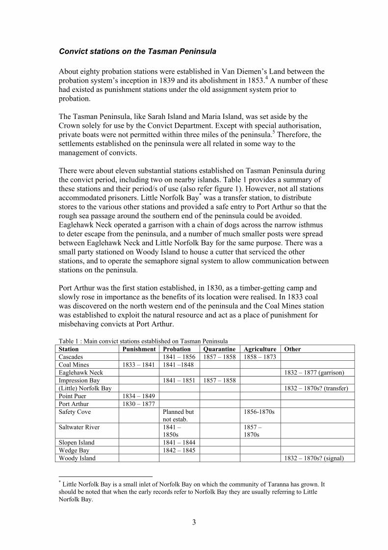
Convict stations on the Tasman Peninsula About eighty probation stations were established in Van Diemen’s Land between the probation system’s inception in 1839 and its abolishment in 1853.4 A number of these had existed as punishment stations under the old assignment system prior to probation. The Tasman Peninsula, like Sarah Island and Maria Island, was set aside by the Crown solely for use by the Convict Department. Except with special authorisation, private boats were not permitted within three miles of the peninsula.5 Therefore, the settlements established on the peninsula were all related in some way to the management of convicts. There were about eleven substantial stations established on Tasman Peninsula during the convict period, including two on nearby islands. Table 1 provides a summary of these stations and their period/s of use (also refer figure 1). However, not all stations accommodated prisoners. Little Norfolk Bay* was a transfer station, to distribute stores to the various other stations and provided a safe entry to Port Arthur so that the rough sea passage around the southern end of the peninsula could be avoided. Eaglehawk Neck operated a garrison with a chain of dogs across the narrow isthmus to deter escape from the peninsula, and a number of much smaller posts were spread between Eaglehawk Neck and Little Norfolk Bay for the same purpose. There was a small party stationed on Woody Island to house a cutter that serviced the other stations, and to operate the semaphore signal system to allow communication between stations on the peninsula. Port Arthur was the first station established, in 1830, as a timber-getting camp and slowly rose in importance as the benefits of its location were realised. In 1833 coal was discovered on the north western end of the peninsula and the Coal Mines station was established to exploit the natural resource and act as a place of punishment for misbehaving convicts at Port Arthur. Table 1 : Main convict stations established on Tasman Peninsula Station Punishment Probation Quarantine Agriculture Other Cascades 1841 – 1856 1857 – 1858 1858 – 1873 Coal Mines 1833 – 1841 1841 –1848 Eaglehawk Neck 1832 – 1877 (garrison) Impression Bay 1841 – 1851 1857 – 1858 (Little) Norfolk Bay 1832 – 1870s? (transfer) Point Puer 1834 – 1849 Port Arthur 1830 – 1877 Safety Cove Planned but
not estab. 1856-1870s
Saltwater River 1841 – 1850s
1857 – 1870s
Slopen Island 1841 – 1844 Wedge Bay 1842 – 1845 Woody Island 1832 – 1870s? (signal) * Little Norfolk Bay is a small inlet of Norfolk Bay on which the community of Taranna has grown. It should be noted that when the early records refer to Norfolk Bay they are usually referring to Little Norfolk Bay.
3
The majority of stations, however, were set up as labour stations following the introduction of the probation system in 1839. Stations such as Coal Mines and the juvenile prison of Point Puer that already existed as punishment stations, adopted probationary characteristics. Following the cessation of transportation in 1853, a number of the stations continued to function as probation stations until c.1856. Subsequently, several of these, including Cascades and Saltwater River became attached to Port Arthur as agricultural outstations.
Jetties and the post-convict period The Tasman Peninsula during the convict era has been described as an ‘island of exile,’ because it was a suitable geographic location for segregating society’s undesirables.6 Surrounded by sea, and with few or no roads, transport and communication to, from and around the peninsula was conducted almost exclusively by shipping. Jetties to support this maritime commerce were a vital piece of infrastructure for the efficient operation of the penal system. However, while the convict era is undoubtedly a seminal period in the history of the Tasman Peninsula, the importance of the jetties to community development in the post-convict, free-settlement period should not be underestimated. Settlers took up parcels of land in new communities centred on the old probation stations. The infrastructure the government established for convict management greatly assisted the orderly progression to a free community on the peninsula. Orchards sprang up across the northern side of the peninsula from the 1880s and continued expanding during the first half of the 20th century. Though better roads had been pushed into the interior, settlers still relied on the sea to transport their produce to external markets. The jetties retained their importance until regular steamer services ceased in the 1950s. The story of the Norfolk Bay jetties is the story of the white settlement of the region, from penal beginnings through to living memory.
4
Chapter 2 Cascades Station
Establishment Cascades Probation Station was established in late-1841, and was the third labour station established on the Tasman Peninsula under the probation system. Cascades, in what is now the community of Koonya, was located approximately midway between the transfer station at Norfolk Bay and the Impression Bay Probation Station.1 The site was named for the small stream that flowed through the valley, over a waterfall, and into the bay.2 The site was chosen primarily to access the stands of tall hardwood forest, supplying timber to other peninsula stations as well as for other government projects, including new wharves in Hobart.3 For the sake of efficiency in transportation, labour and materials, Cascades became the major centre for timber production on the peninsula between 1846 and 1856, surpassing Port Arthur during that period.4 Twenty-five convicts with their supervising constables initially settled the station.5 In 1842-43, there were 205 prisoners, and by 1846 the number of prisoners had risen to 445, of which about 200 were employed in agriculture.6, 7 However, by the following year (1847), the number of prisoners had dropped to 403 (of which 104 were in chains).8 This is despite the fact that in 1847 Cascades Station, along with Saltwater River and Impression Bay, were used to help accommodate 600 prisoners from Norfolk Island.9 A steady decline in prisoner numbers is evident over the next 10 years. In 1850 numbers had fallen to 304 prisoners (183 employed in timber related tasks) and again to 299 in 1852.10 In 1852, the probation stations at Cascades, Impression Bay and Saltwater River were proclaimed by Executive Council as “Houses of correction for the reception and punishment of transported and other male and female convicts.”11 However, the probation system was short-lived, and was terminated the following year. Although transportation had ended, there were still prisoners at the station that had to see their sentence through. By 1856, the area’s timber resources were exhausted, and Cascades station was evacuated and its prisoners transferred elsewhere.12 In November of that year, Cascades (along with Impression Bay) became a quarantine station for a total of three months, receiving 86 quarantined immigrants. In February 1858 it was placed under a caretaker, A. T. Stuart.13 By 1863 only nine men remained in residence, growing vegetable crops and carrying out some animal herding.14 This low level of activity continued until the station closed in 1873. In 1882, the buildings at Cascades, like those at other convict stations, were in poor condition, and the land they stood on was sold off by the Government. The list of private owners is as follows: Henry Chesterman (1882), James Roxburgh McClymont (1891), Edward Brown (1901), George Worladge and Thomas Frank Lock (1907) and James Dyson Lacey (1907).15 In 1915, the property passed into the Clark family
5
commencing with Belmont Moses Clark (1915), Alfred Belmont Clark (1951) and Donald Alfred Clark (1970). The community of Cascades formally changed its name to Koonya in 1903.16 The property ‘Cascades’ is listed on the National Estate and Tasmanian Heritage Register, and many of the buildings have been refurbished as guest accommodation. Although in private ownership, a management plan was prepared under section 19 of the National Parks and Wildlife Act 1970.17 However, the management plan does not encompass the headland or any infrastructure associated with the jetty.
Operations From 1842 land at Cascades was progressively cleared, first for roads and buildings, and later for agriculture, but more importantly timber production. By 1846, 200 of the station’s 445 prisoners were employed in agriculture. The years 1846 to 1847 saw quite a variety in the station’s production. In 1846, wheat was first sown and 500 bushels were harvested.18 However, the experiment with wheat failed and was abandoned in 1847; agricultural cropping changed to vegetables.19 Also in 1846, after Impression Bay was converted to an invalid depot, Cascades took over the manufacture of carts, wheelbarrows and other implements required by the Convict Department.20 However, by far the biggest priority for production at Cascades was timber. 1846 was also the year in which Cascades surpassed Port Arthur as the prime timber production centre on the Tasman Peninsula.21 As a result production, and consequently infrastructure, steadily increased. Production received a further boost in 1851 when a steam sawmill was established about one mile (1200m) south of the main settlement. It is likely that even prior to the installation of the steam mill, the same site was used for sawing timber, rather than at the main settlement or at the site of felling operations.22 In 1853, Quaker missionary Frederick Mackie described an interesting method of transporting the timber to the sawmill via a timber-lined ditch heading downslope from the harvesting area to the sawmill. Logs would be placed in the ditch, then shoot down under gravity at great speed until reaching the mill.23 From the mill, timber produce, cut to order, was transported to the Cascades jetty via a tramway (see below), and stockpiled on the jetty awaiting trans-shipment by passing vessels.24
Maritime infrastructure The maritime infrastructure around Cascades has an interesting evolution. It is known that construction of a long jetty commenced within weeks of the first party arriving in late-1841. The jetty’s size and maintenance requirements have been said to be considerable.25 In June 1846, La Trobe reported that 44 hard labour convicts were “erecting a jetty, &c.”26 However, it is not clear whether this was part of the initial construction phase (4½ years after commencement), an extension of the existing jetty
6
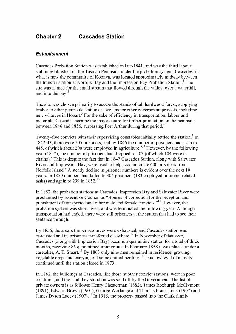
after it had been initially completed, or construction of an entirely separate (new) structure. Given the speed of construction of jetties at the Coal Mines, it is unlikely that this jetty would still be under initial construction in 1846. The Superintendent at Cascades was said to be “very steady and energetic.”27 The most likely explanation is that the type of work being performed in 1846 was actually maintenance rather than construction. The tramway from the sawmill to the jetty is shown on the plan of the station in 1857 (figure 2.1), but it has been conjectured that the tramway would have been in place before the increased production rates following the installation of the steam sawmill in 1851.28 The tramway ran in a straight line from the mill until it reached the south western corner of the settlement, where it veered westerly and circled the bay to the western headland and jetty. Given that the station (and its infrastructure) post-dates the station at Saltwater River, it is likely that the tramway at Cascades used similar iron rails and rail chairs, rather than the older-style timber rails used at the Coal Mines. The tramway skirted close to the shore where it approached the jetty and was held in place by a retaining wall some 200ft in length.29
Figure 2.1: Cascades Station in 1857 showing route of tramway from sawmill to jetty. (AOT PWD 266/1842, ‘Cascades, Tasman Peninsula,’ c. May 1857)
7
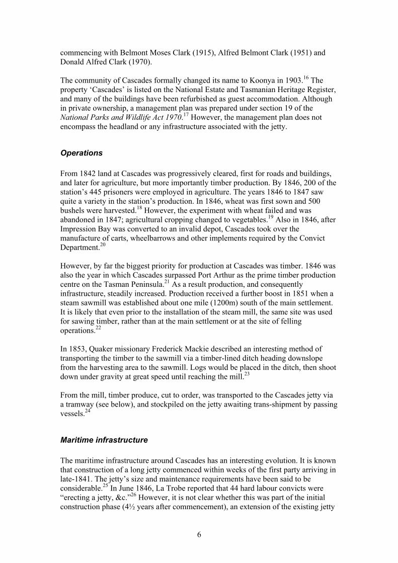
Timber was stockpiled either on the pier itself or in a nearby shed whilst awaiting shipment.30 Unfortunately, the 1857 plan does not show the jetty or shed on the headland, so the shed’s exact position is unknown. However, a second-generation rebuild in 1885 used the original abutment, and the plans show an existing shed, which may be the same one (figure 2.4). There is little mention of a formal ballast dumping area in the historical record. Timber was mainly transported to (Little) Norfolk Bay (for overland shipment to Port Arthur) via the Woody Island cutter, steamers and a number of launches.31 Whether vessels from other ports, such as Hobart Town, arrived at Cascades in ballast for the express purpose of shipping timber is not known. If such arrangements were made, then it is feasible that evidence of ballast dumping will be found in the archaeological record. Guiler (1998: 170) states that a second jetty (known as the Old Jetty) was built at the end of jetty road as a separate structure to the convict-built jetty. Little is known about it but it is said that it was as long as the convict jetty, and that the only remains are ballast stones dumped beside it. The piles from one of these jetties were still standing in 1888, when concerns were made about the risk to shipping at the adjacent new jetty (see below).32 A survey conducted by G.C. Smith in 1876 shows the position of the original convict-built jetty (figure 2.2). By that time the jetty was in ruins, and the plan shows the jetty to be in two sections with a large gap between.
Figure 2.2: 1876 survey map by G.C. Smith showing position of the original convict-built jetty at Cascades. The route chosen for the new approach road in 1895 is shown in blue. (AOT PWD 18/1/2862, G.C. Smith,‘ Tasman Peninsula Cascades,’ 1876)
In August 1882, Parliament voted £1100 to construct new jetties at Cascades, Impression Bay and Carnarvon (Port Arthur).33 For most of 1883, debate raged on
8
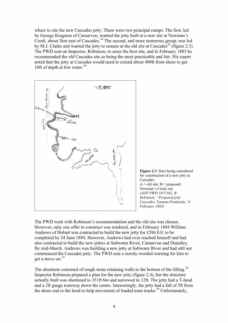
where to site the new Cascades jetty. There were two principal camps. The first, led by George Kingston of Carnarvon, wanted the jetty built at a new site at Newman’s Creek, about 3km east of Cascades.34 The second, and more numerous group, was led by M.J. Clarke and wanted the jetty to remain at the old site at Cascades35 (figure 2.3). The PWD sent an Inspector, Robinson, to asses the best site, and in February 1883 he recommended the old Cascades site as being the most practicable and fair. His report noted that the jetty at Cascades would need to extend about 400ft from shore to get 10ft of depth at low water.36
Figure 2.3: Sites being considered for construction of a new jetty at Cascades. A = old site; B = proposed Newman’s Creek site. (AOT PWD 18/1/362, R. Robinson, ‘ Proposed jetty Cascades, Tasman Peninsula,’ 6 February 1883)
The PWD went with Robinson’s recommendation and the old site was chosen. However, only one offer to construct was tendered, and in February 1884 William Andrews of Hobart was contracted to build the new jetty for £586.0.0, to be completed by 24 June 1884. However, Andrews had over reached himself and had also contracted to build the new jetties at Saltwater River, Carnarvon and Dunalley. By mid-March, Andrews was building a new jetty at Saltwater River and had still not commenced the Cascades jetty. The PWD sent a sternly-worded warning for him to get a move on.37 The abutment consisted of rough stone retaining walls to the bottom of the filling.38 Inspector Robinson prepared a plan for the new jetty (figure 2.4), but the structure actually built was shortened to 351ft 6in and narrowed to 12ft. The jetty had a T-head and a 2ft gauge tramway down the centre. Interestingly, the jetty had a fall of 5ft from the shore end to the head to help movement of loaded tram trucks.39 Unfortunately,
9
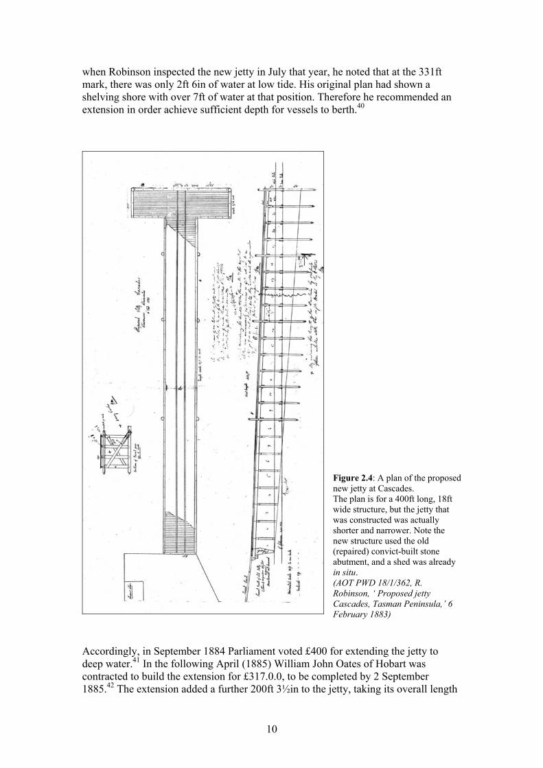
when Robinson inspected the new jetty in July that year, he noted that at the 331ft mark, there was only 2ft 6in of water at low tide. His original plan had shown a shelving shore with over 7ft of water at that position. Therefore he recommended an extension in order achieve sufficient depth for vessels to berth.40
Figure 2.4: A plan of the proposed new jetty at Cascades. The plan is for a 400ft long, 18ft wide structure, but the jetty that was constructed was actually shorter and narrower. Note the new structure used the old (repaired) convict-built stone abutment, and a shed was already in situ. (AOT PWD 18/1/362, R. Robinson, ‘ Proposed jetty Cascades, Tasman Peninsula,’ 6 February 1883)
Accordingly, in September 1884 Parliament voted £400 for extending the jetty to deep water.41 In the following April (1885) William John Oates of Hobart was contracted to build the extension for £317.0.0, to be completed by 2 September 1885.42 The extension added a further 200ft 3½in to the jetty, taking its overall length
10
to 551ft 9½in. It consisted of a further ten piers with piles 18ft 2½in from centre to centre, and a T-head at the end.43 A further £250 (to be shared with Impression Bay) was voted later in 1885 for completion of the jetty.44 However, enough funds had already been allocated to cover the tendered construction cost, so it is not known why these funds were needed or what they were used for. In September 1891 Parliament allocated another £200 to build the approach and an extension to the jetty.45 However, it seems that it was not acted upon for four years. It was not until October 1895 that the Flynn Brothers (Michael and Laurence), with brothers Timothy and Laurence Duggan, of Woodstock, Huon, were contracted to extend the existing jetty by 80ft. They tendered the price of £123.15.2 and the work was to be completed by 15 January 1896.46 In March 1896, T. Hoare was contracted to prepare the approaches to the jetty for the sum of £27.19.6, to be completed by 12 June 1896. With this extension the jetty was now almost 632ft in length. By 1896, the original road to the jetty, via the convict buildings at Cascades, was considered inadequate. A deal was struck whereby the Cascades landowner, James McClymont, received from the Crown the land on which the original road lay in exchange for some land on which to build a new road (figure 2.2).47 The Governor proclaimed the new road in March 1897.48 By 1926, Cascades (now Koonya) was shipping 15,000 cases of apples – increasing annually. Complaints were made to the PWD that the T-head was too small for a horse and cart to turn around on, causing extensive delays in loading.49 The PWD Inspector supported the Council’s request for a larger T-head to be built. Council wanted the present 28ft x 22ft T-head to be extended to 48ft x 32ft (according to the Inspector, the overall length of the jetty was 622ft). He estimated the cost to be £392.6.8.50 Accordingly, authority to expend £400 on making the extension was granted.51 During 1929, £46.0.0 was spent on repairs including replacement of broken piles, and emergency repairs to the stone abutment, which had been badly damaged by recent heavy seas.52 More orchards were planted and as the trees came into bearing, pressure on the loading infrastructure mounted. In 1931, the Tasman Council requested yet another extension to the T-head.53 The PWD allocated £70 for the task, and the T-head was extended to 60ft x 60ft.54, 55 The jetty was now becoming increasingly rotten, and £214 was spent on repairs including replacement of girders, decking and kerbs. The tramway was intended to be replaced, but because produce was being carted to the T-head by both horse and motor lorries, residents requested that no new tramway be laid as it would be more impediment than help.56 By 1939, excessive congestion was occurring at the head of the jetty. The neck was fairly narrow and there was not room for two vehicles to pass, necessitating vehicles to wait on either the shore or the head while another vehicle was on the neck. Yet another extension to the head was requested, this time to diagonally ‘fill in’ the neck of the ‘T’ on the western side.57 The PWD expended £43 on this extension.58 By 1943, the state of the jetty was becoming a concern and there was some talk of completely rebuilding it. One sector of the community tried to use the opportunity to have the new jetty built more conveniently for them at Shelley Beach Point.59
11
However, the engineer’s report did not see any advantage in this, and therefore the PWD decided to make extensive repairs to the existing jetty.60 The repairs amounted to almost a complete rebuild with new piles, beams decking and abutment and were nearly complete in early February 1944. However, it seems that further works were required because in June the amount allocated to the work was increased from £900 to £1,150.61 In November, yet another £10 was spent on repairing the cattle-loading ramp, which had become unsafe for use.62 In 1949-1950 The Koonya jetty, along with five other jetties, was repaired for £3,766.63 It seems Koonya jetty took a disproportionate amount of this, requiring £1,120 for its repairs.64 The jetty was plainly in its sunset years. By 1953, the PWD produced an estimate of £1,720.0.0 for its demolition. 65 However, Mr A.B. Clark of Cascades requested the opportunity to purchase the jetty shed in 1954, and was told that the jetty would stand for some years yet, and that the shed was not for sale.66 A photo of the jetty in c.1950 shows a shed in the elbow of the “L”.67 However, once the M.V. Naracoopa and the M.V. Cartela stopped using it in the 1950s, the jetty quickly fell in to disrepair, and eventually broke up and washed ashore.68
12
Chapter 3 Coal Mines Station
Establishment In 1833 surveyors Woodward and Hughes discovered coal on the Tasman Peninsula at Plunkett Point. Mining commenced at Plunkett Point as a government operation in 1834 using convict labour.1 Despite its inferior quality, the coal from Plunkett Point found a ready market in Hobart because it sold for less than half the price of coal that had, until then, been imported from Newcastle.2 The presence of coal seams at various locations in Van Diemen’s Land had been known since 1804, but the operation at Plunkett Point was the first to be mined successfully.3 Under the convict assignment system, mining was originally initiated as a punishment for the worst behaved convicts at Port Arthur. However, in 1841 the assignment system was superseded by the probation system. When the Coal Mines became a probation station, the mines were worked by prisoners who had mining experience instead of using forced labour as a result of punishment.4 Mining continued under Government control until June 1848, when it was leased to private operators.5 The lease passed through a number of hands over the next half century: Alexander Clarke (1848), James Fulton (1851), William Nichols and John Thomas (1856), and James Hurst (1858) who retained the lease, in conjunction with Messrs Rheuben and Turner, until 1876 when Hurst died and work at the mine was aborted.6 Lease records are inconclusive after 1876. In 1878, Thomas Perkins and a man named Goldsmith made separate lease applications. Goldsmith’s application was refused, and it is not known if Perkins’ was successful.7 By the late 1880s enterprising locals saw the potential of the site as a tourist destination, but there was some government resistance.8 In 1894 Cheverton and Gordon acquired the lease on certain areas of the Coal Mines including two along the foreshore in order to collect coal shale that had washed up on the beach. These leases expired in 1901, and no records of further mining leases exist.9 In the early part of the 20th century, the land was being leased for sheep grazing. Lessees included Jacob Burden (from 1901) and John Price (from 1925). During this period the infrastructure was left to decay and theft was prevalent until 1938. Materials from the site were used elsewhere on the peninsula for building projects. For example, in the 1920s the commissariat store was dismantled and the stone was used to build a church at Dunalley.10 In 1938, four hectares of the Coal Mines area were gazetted as a Scenic Reserve under the Scenery Preservation Act 1915. In 1949, the area under protection was extended to 81 hectares. In 1966, the area was proclaimed a State Reserve (No. 195), and increased in size to 214 hectares. In 1971, the site was declared a Historic Site under the National Parks and Wildlife Act 1970, and management was transferred to the Parks and Wildlife Service11. The Coal Mines Historic Site was incorporated into the Port Arthur Historic Site in December 2004.12
13
Mining operations Coal seams were first mined in 1833 from the shingle beach; workings were accessed from adits driven from the shore.13 The operation used the ‘bord and pillar’ technique.14 With this technique, wide (up to 9m) galleries known as bords were mined; pillars of coal were left between the galleries to support the roof. Later, the coal in the pillars was removed in cross-drives between the bords, leaving a grid pattern of passages at regular intervals. Adit passages were also supported by timber crossbars and uprights produced at Impression Bay, which were delivered to the Coal Mines daily by a launch operated by convict boatmen and a paid coxswain.15 A shaft, some two or three hundred meters inland, was sunk to connect with the inland end of the adits. By June 1834, a second shaft was sunk, and another coal seam discovered.16 It was reported that 500 tons of coal was being shipped from the mines every month.17 Coal from the face was shovelled into skips or carts, and a plateway* conveyed the coal to the adit entrance. The coal was screened to remove rock and oversized coal.18 The screened coal was then stockpiled on the wharf ready to be conveyed to a transport vessel at the jetty head via the plateway.19 Joseph Lacey, a convict with mining experience, initially supervised the operations from 1833, and in 1837 Dr John Lhotsky arrived to provide professional assistance.20 Dr Lhotsky promptly surveyed the mines, noted potentially dangerous aspects of the mine infrastructure, and commenced boring deeper and surveying for new coal areas.21 Soon, driving was occurring on two levels from the base of the underground shafts, and coal production averaged 35 tonnes per day. 22, 23 In 1839 a new shaft was sunk inland and to the northwest of the foreshore adit. By April of that year it was 106ft deep.24 The mines were always troubled by water seepage. Initially, manually operated windlasses pumped the water out.25 However, continued water seepage in the shaft caused work to cease and from December 1841 another new shaft was sunk north of the 1839 shaft.26 To combat water seepage, a 10hp steam engine was installed above the 1841 shaft to drain the water and hoist the coal. By this stage production had increased from 8,600 tonnes to 10,600 tonnes per annum.27 In 1842, convict mining engineer William Dawson recommended sinking a main shaft from the top of the hill to facilitate drainage of the works, and provide sufficient elevation to enable a counter-weighted inclined tramway to self-transport coal to a new loading jetty built at Plunkett Point.28 As an interim measure, another shaft began operation from April/May 1843 while a new main shaft was being constructed.29 Dawson’s new main shaft became operational in 1845 and was supported by a complex incorporating a blacksmith shop, a workshop and a large engine complex with a boiler (using the steam engine from the 1841 shaft).30 The boiler still exists and is located at the shaft. Inclined tramways to the new jetty serviced both the 1841 and 1845 shaft complexes.
* A kind of tramway using timber boards as rails (see figure 3.3).
14
In 1845 production had reached 50 tonnes per day. However, by 1847, production had reverted to half this amount, and eventually by 1848, the mines were leased to private concerns. By 1877, an estimated 60,000 tonnes of coal had been extracted from the site.31 Officially mining ceased in that year with the death of the last lessee James Hurst. However, there is anecdotal evidence that some mining was still occurring in 1889, and at least one of the jetties was still operational at that time.32
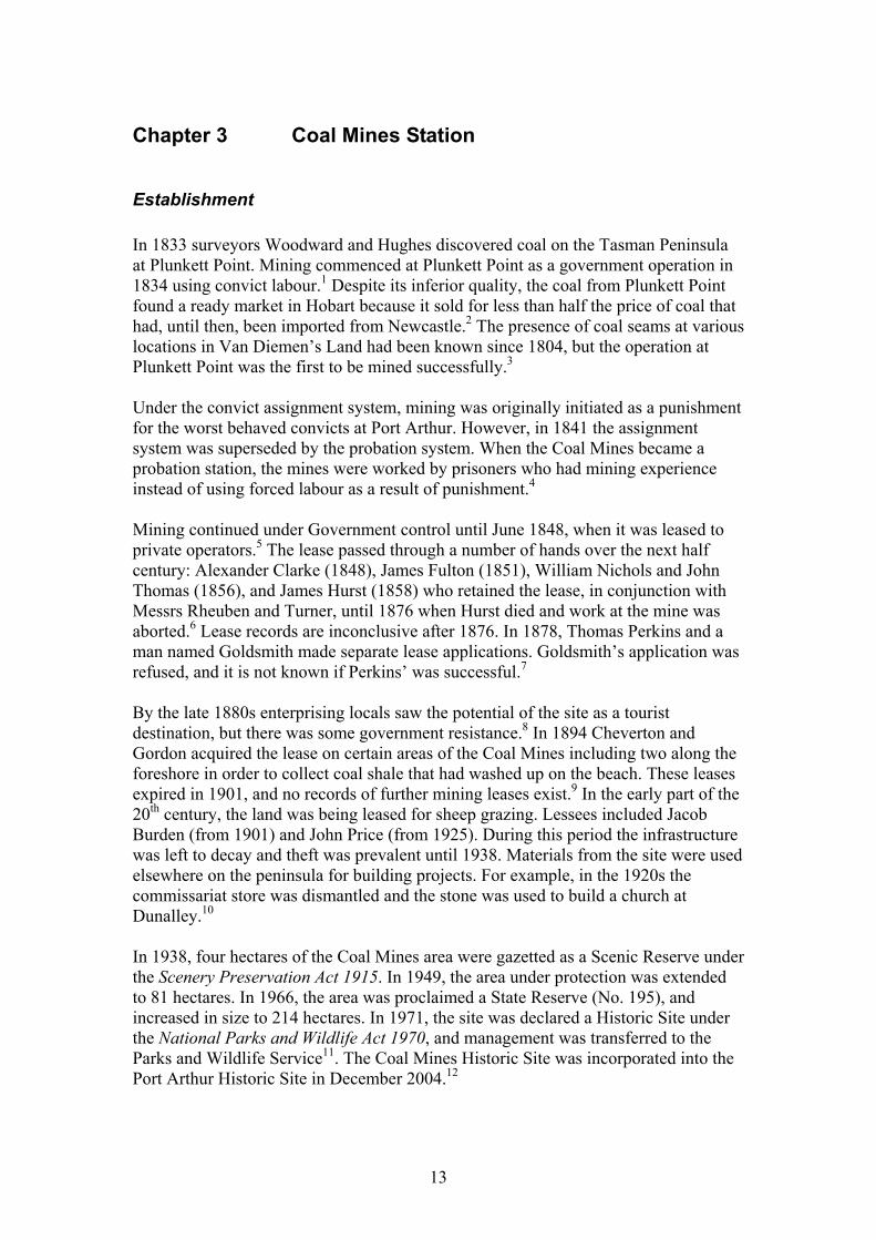
Maritime infrastructure The maritime infrastructure at the Coal Mines consisted chiefly of jetties used to service the vessels that were the station’s main form of transport and communication. A total of five jetties were constructed during the mine’s operational period. The initial jetty consisted of a substantial wharf built opposite the 1833 adit entrance, with a trestle pier extending 360ft (110m) into the bay.33 This jetty appears to have been constructed in 1836 to a similar design as the jetty built at Eaglehawk Neck.34 Coal was stockpiled on the wharf, and then transported via a tramway to vessels at the end of the jetty. However, the near-shore waters of the bay are shallow and the jetty was not very long, and by 1837, it was already shown to be inadequate for servicing large vessels.
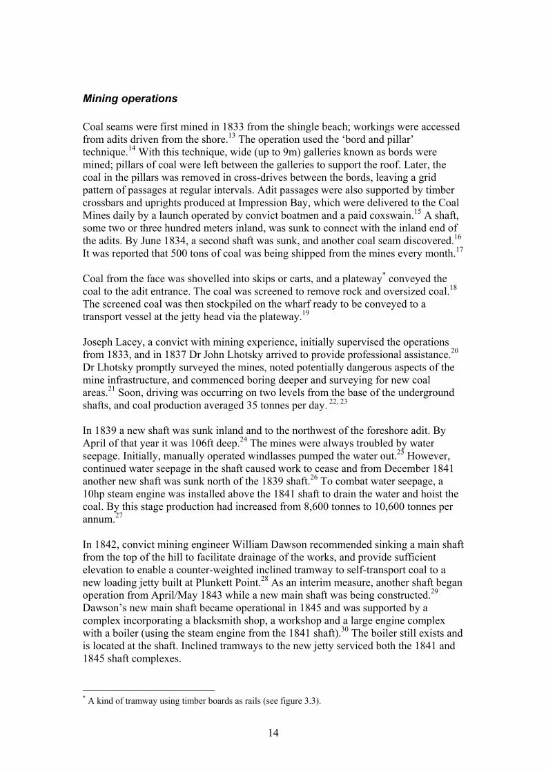
Figure 3.1: A plan of the Coal Mines c.1837. The original wharf and jetty (Jetty 1) is to the left, and the new much longer jetty (Jetty 2) is to the right. (AOT CSO 5/72/1584, ‘Mining establishment at Coal Point,’ 1837, p.85.) To remedy this, a new pile jetty was constructed from the point south of the wharf, and, because this jetty was much longer and reached deeper water, was able to accommodate vessels of more than 300 tons burthen.35 An 1837 plan of the Coal Mines (figure3.1) shows the new jetty and gives its dimensions as 920ft (280.4m) long by 11ft wide. These dimensions are confirmed in the personal journal of Lady Jane Franklin who visited the site in March 1837. She refers to a railroad being cut to another jetty ‘not quite finished of timber projecting 306yds 2ft (280.4m), 10ft 6in wide … Piles at end are 33ft deep or high, 45ft wide is [the] quay at [the] end.’36 In 1838, following damage caused by the Swan River Packet, an additional trestle was
15
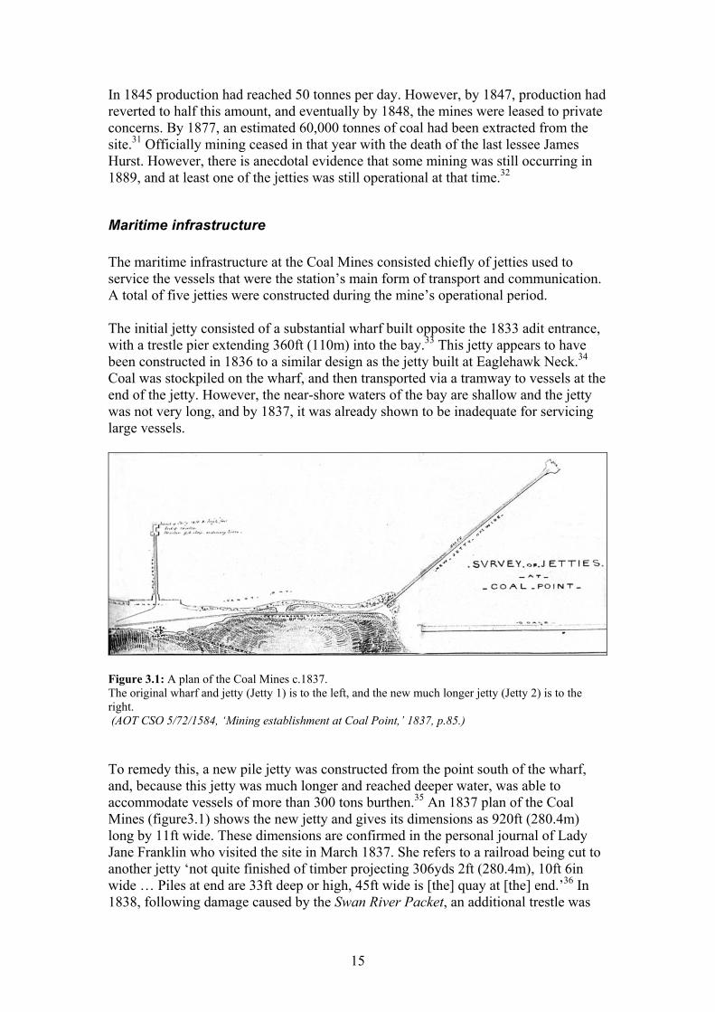
added to the jetty taking it beyond the ballast dumping area.37 The additions must have added a further 48.8m to the length of the jetty, because Thomas Lempriere reported the dimensions of the jetty in 1838 as 360yds (329.2m) long, and ‘10ft wide until near the end where it expands to 52ft.’38 The quay at the end of the jetty seems to have been lengthened a further 7ft. There are also some interesting construction details (figure 3.2).
Figure 3.2: Construction detail of the new 1837 jetty (Jetty 2) showing the interesting shoreward-leaning batter to the piles. (AOT CSO 5/72/1584, ‘Mining establishment at Coal Point,’ 1837, p.85.) Coal was transported to vessels at the end of the jetty via a double tramway – one for outgoing loaded carts, the other for returning empty carts. The tramways built for Jetties 1 and 2 had rails (plateways) made of timber rather than the later iron rails used elsewhere (figure 3.3)
Figure 3.3: Timber tram rails used for carting coal to Jetties 1 and 2. (AOT CSO 5/103/2329, ‘Sections of railroad proposed to be constructed at Coal Point,’ 12 January 1838, p.125.)
16
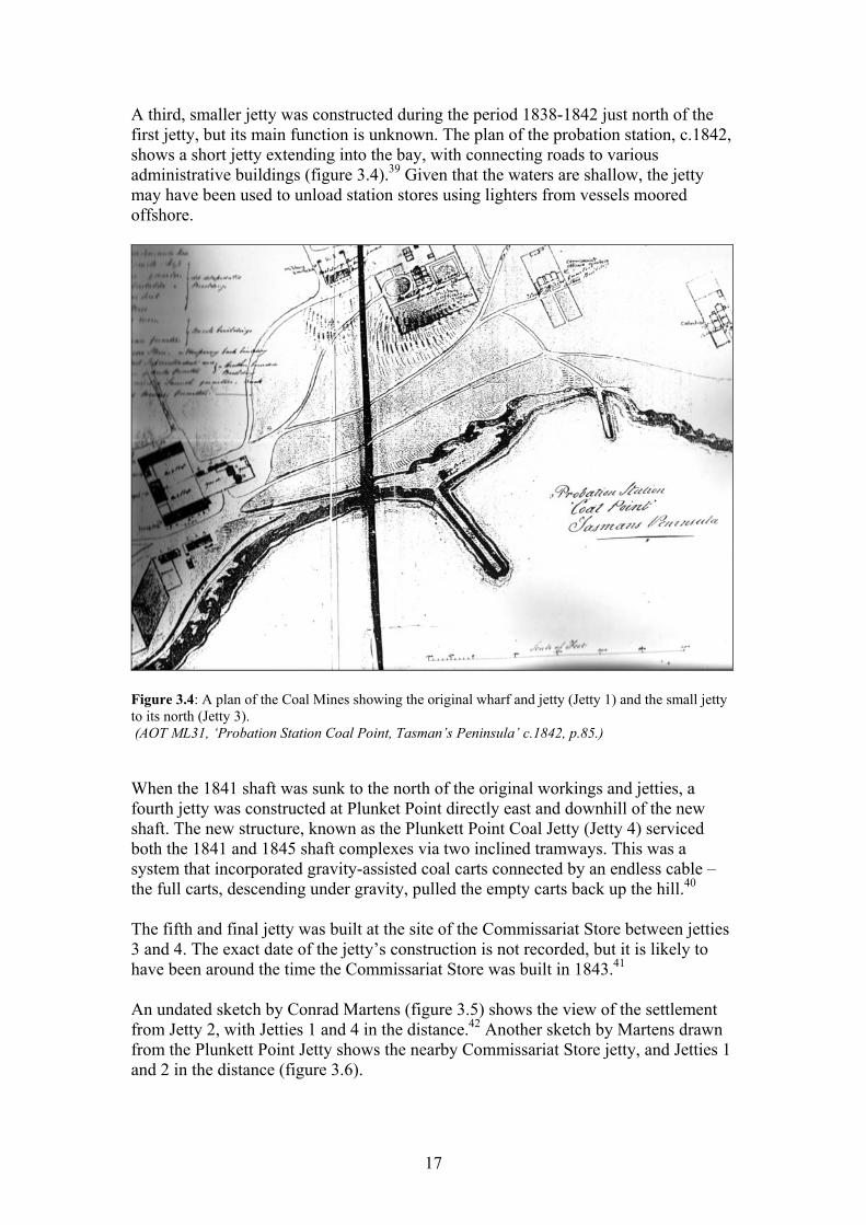
A third, smaller jetty was constructed during the period 1838-1842 just north of the first jetty, but its main function is unknown. The plan of the probation station, c.1842, shows a short jetty extending into the bay, with connecting roads to various administrative buildings (figure 3.4).39 Given that the waters are shallow, the jetty may have been used to unload station stores using lighters from vessels moored offshore.
Figure 3.4: A plan of the Coal Mines showing the original wharf and jetty (Jetty 1) and the small jetty to its north (Jetty 3). (AOT ML31, ‘Probation Station Coal Point, Tasman’s Peninsula’ c.1842, p.85.) When the 1841 shaft was sunk to the north of the original workings and jetties, a fourth jetty was constructed at Plunket Point directly east and downhill of the new shaft. The new structure, known as the Plunkett Point Coal Jetty (Jetty 4) serviced both the 1841 and 1845 shaft complexes via two inclined tramways. This was a system that incorporated gravity-assisted coal carts connected by an endless cable – the full carts, descending under gravity, pulled the empty carts back up the hill.40 The fifth and final jetty was built at the site of the Commissariat Store between jetties 3 and 4. The exact date of the jetty’s construction is not recorded, but it is likely to have been around the time the Commissariat Store was built in 1843.41 An undated sketch by Conrad Martens (figure 3.5) shows the view of the settlement from Jetty 2, with Jetties 1 and 4 in the distance.42 Another sketch by Martens drawn from the Plunkett Point Jetty shows the nearby Commissariat Store jetty, and Jetties 1 and 2 in the distance (figure 3.6).
17
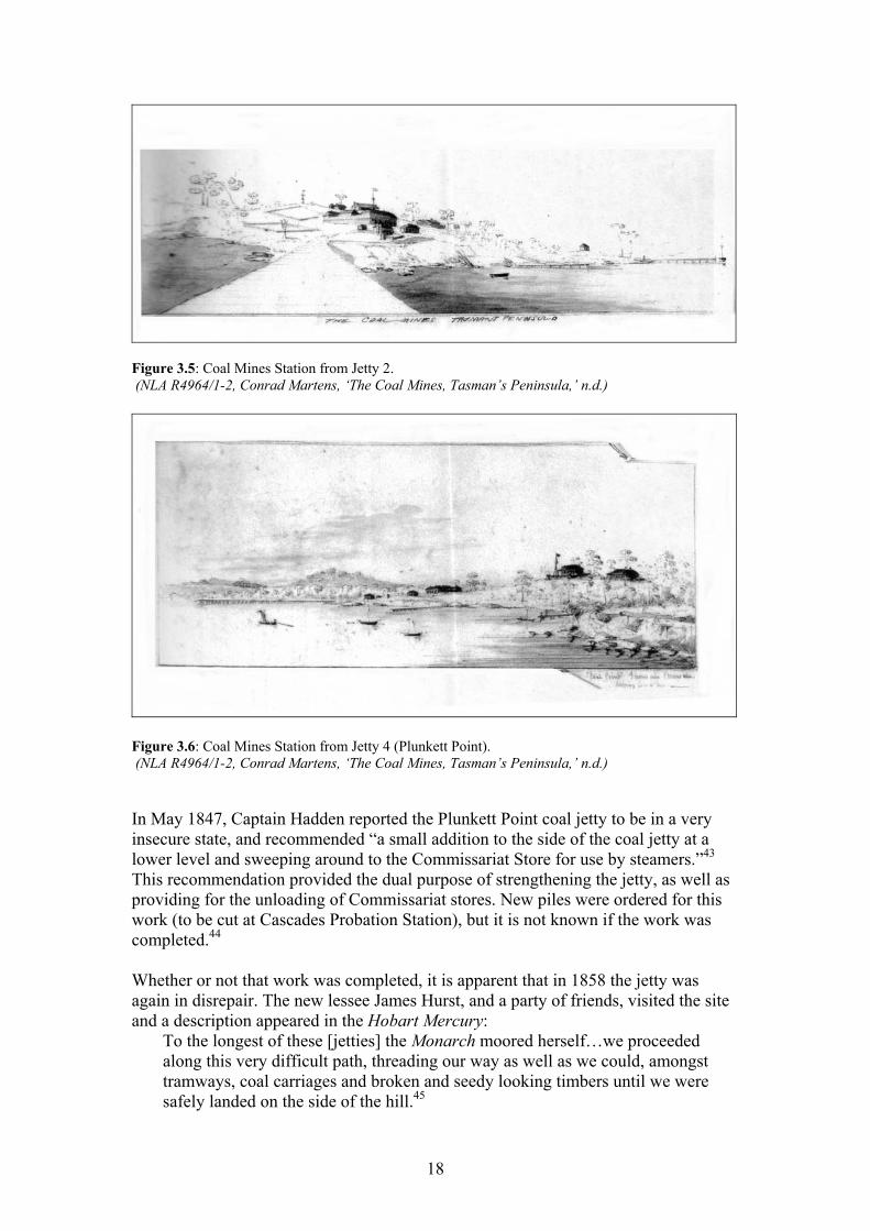
Figure 3.5: Coal Mines Station from Jetty 2. (NLA R4964/1-2, Conrad Martens, ‘The Coal Mines, Tasman’s Peninsula,’ n.d.)
Figure 3.6: Coal Mines Station from Jetty 4 (Plunkett Point). (NLA R4964/1-2, Conrad Martens, ‘The Coal Mines, Tasman’s Peninsula,’ n.d.) In May 1847, Captain Hadden reported the Plunkett Point coal jetty to be in a very insecure state, and recommended “a small addition to the side of the coal jetty at a lower level and sweeping around to the Commissariat Store for use by steamers.”43 This recommendation provided the dual purpose of strengthening the jetty, as well as providing for the unloading of Commissariat stores. New piles were ordered for this work (to be cut at Cascades Probation Station), but it is not known if the work was completed.44 Whether or not that work was completed, it is apparent that in 1858 the jetty was again in disrepair. The new lessee James Hurst, and a party of friends, visited the site and a description appeared in the Hobart Mercury:
To the longest of these [jetties] the Monarch moored herself…we proceeded along this very difficult path, threading our way as well as we could, amongst tramways, coal carriages and broken and seedy looking timbers until we were safely landed on the side of the hill.45
18
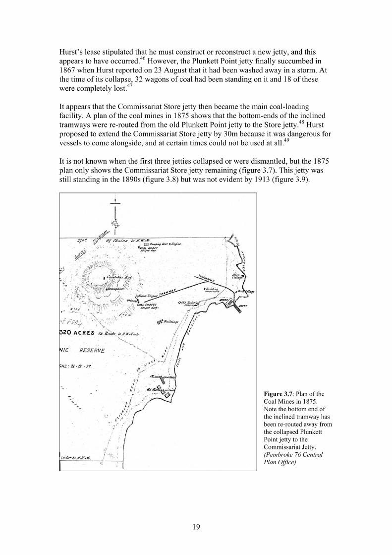
Hurst’s lease stipulated that he must construct or reconstruct a new jetty, and this appears to have occurred.46 However, the Plunkett Point jetty finally succumbed in 1867 when Hurst reported on 23 August that it had been washed away in a storm. At the time of its collapse, 32 wagons of coal had been standing on it and 18 of these were completely lost.47 It appears that the Commissariat Store jetty then became the main coal-loading facility. A plan of the coal mines in 1875 shows that the bottom-ends of the inclined tramways were re-routed from the old Plunkett Point jetty to the Store jetty.48 Hurst proposed to extend the Commissariat Store jetty by 30m because it was dangerous for vessels to come alongside, and at certain times could not be used at all.49 It is not known when the first three jetties collapsed or were dismantled, but the 1875 plan only shows the Commissariat Store jetty remaining (figure 3.7). This jetty was still standing in the 1890s (figure 3.8) but was not evident by 1913 (figure 3.9).
Figure 3.7: Plan of the Coal Mines in 1875. Note the bottom end of the inclined tramway has been re-routed away from the collapsed Plunkett Point jetty to the Commissariat Jetty. (Pembroke 76 Central Plan Office)
19
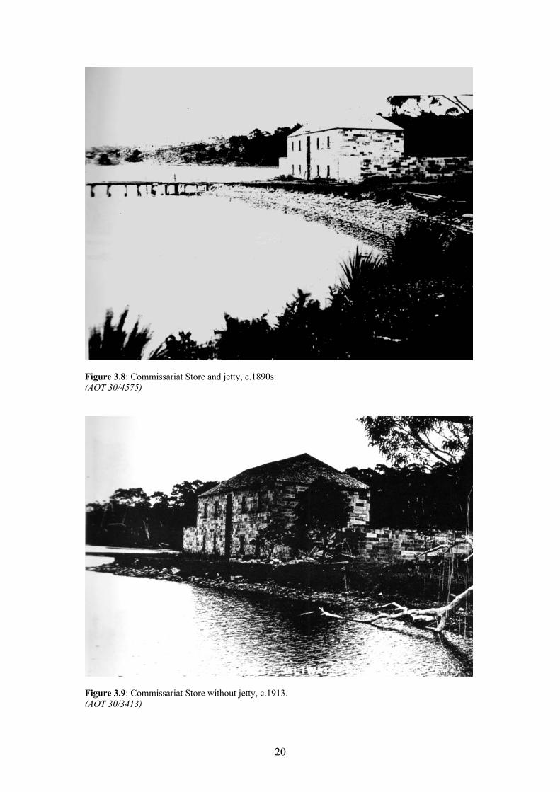
Figure 3.8: Commissariat Store and jetty, c.1890s. (AOT 30/4575)
Figure 3.9: Commissariat Store without jetty, c.1913. (AOT 30/3413)
20
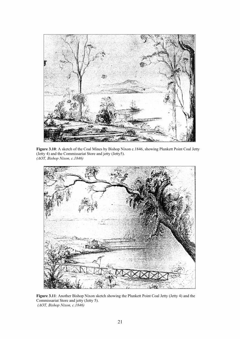
Figure 3.10: A sketch of the Coal Mines by Bishop Nixon c.1846, showing Plunkett Point Coal Jetty (Jetty 4) and the Commissariat Store and jetty (Jetty5). (AOT, Bishop Nixon, c.1846)
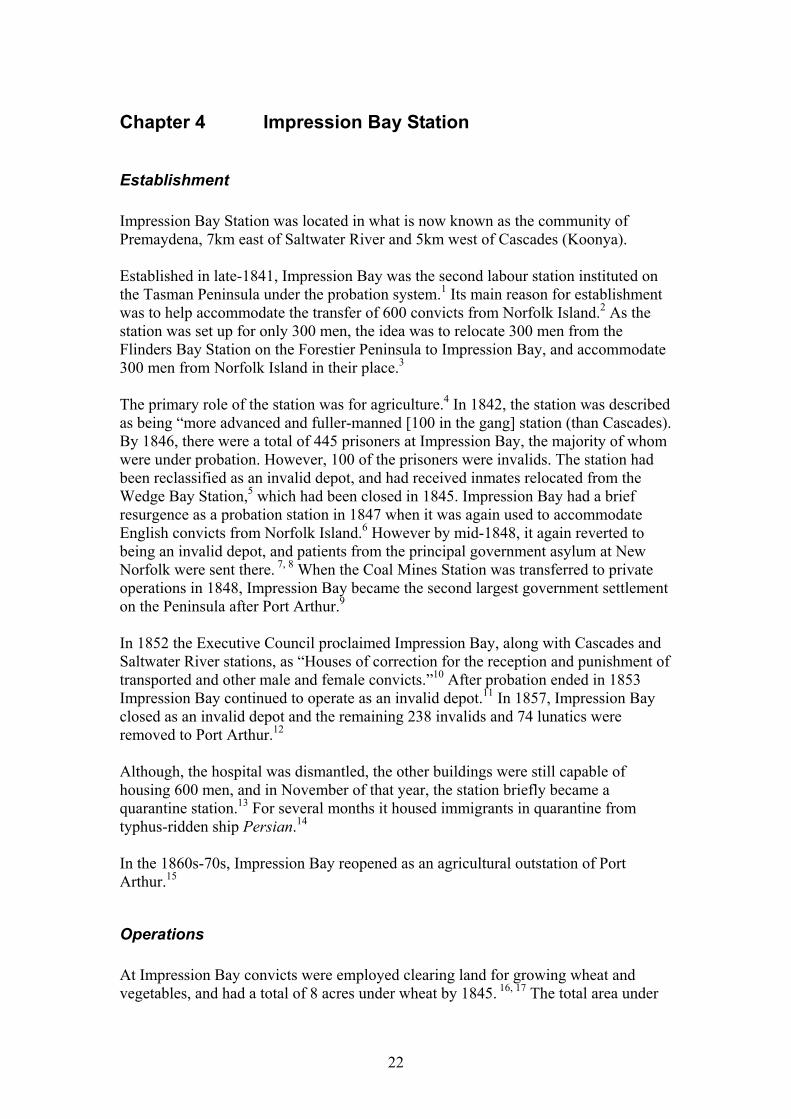
Figure 3.11: Another Bishop Nixon sketch showing the Plunkett Point Coal Jetty (Jetty 4) and the Commissariat Store and jetty (Jetty 5). (AOT, Bishop Nixon, c.1846)
21
Chapter 4 Impression Bay Station
Establishment Impression Bay Station was located in what is now known as the community of Premaydena, 7km east of Saltwater River and 5km west of Cascades (Koonya). Established in late-1841, Impression Bay was the second labour station instituted on the Tasman Peninsula under the probation system.1 Its main reason for establishment was to help accommodate the transfer of 600 convicts from Norfolk Island.2 As the station was set up for only 300 men, the idea was to relocate 300 men from the Flinders Bay Station on the Forestier Peninsula to Impression Bay, and accommodate 300 men from Norfolk Island in their place.3 The primary role of the station was for agriculture.4 In 1842, the station was described as being “more advanced and fuller-manned [100 in the gang] station (than Cascades). By 1846, there were a total of 445 prisoners at Impression Bay, the majority of whom were under probation. However, 100 of the prisoners were invalids. The station had been reclassified as an invalid depot, and had received inmates relocated from the Wedge Bay Station,5 which had been closed in 1845. Impression Bay had a brief resurgence as a probation station in 1847 when it was again used to accommodate English convicts from Norfolk Island.6 However by mid-1848, it again reverted to being an invalid depot, and patients from the principal government asylum at New Norfolk were sent there. 7, 8 When the Coal Mines Station was transferred to private operations in 1848, Impression Bay became the second largest government settlement on the Peninsula after Port Arthur.9 In 1852 the Executive Council proclaimed Impression Bay, along with Cascades and Saltwater River stations, as “Houses of correction for the reception and punishment of transported and other male and female convicts.”10 After probation ended in 1853 Impression Bay continued to operate as an invalid depot.11 In 1857, Impression Bay closed as an invalid depot and the remaining 238 invalids and 74 lunatics were removed to Port Arthur.12 Although, the hospital was dismantled, the other buildings were still capable of housing 600 men, and in November of that year, the station briefly became a quarantine station.13 For several months it housed immigrants in quarantine from typhus-ridden ship Persian.14 In the 1860s-70s, Impression Bay reopened as an agricultural outstation of Port Arthur.15
Operations At Impression Bay convicts were employed clearing land for growing wheat and vegetables, and had a total of 8 acres under wheat by 1845. 16, 17 The total area under
22
cultivation in 1845 was 21 acres 0 roods 20 perches, and produce for that year included wheat, barley, carrots, turnips, cabbage, onions and leeks.18 However, the soils were not very satisfactory for agriculture, so some supplementary timber milling and manufacturing were carried out.19 A considerable number of convict ‘mechanics’ were employed to produce furniture, nails, casks, barrows, messing and barrack utensils, etc for the Convict Department.20 However, this task was transferred to Cascades in 1846, after Impression Bay’s conversion to an Invalid Depot. 21 Large quantities of sawn timber were supplied to the Coal Mines for use as crossbars and uprights for supporting the roofs of the adit passages.22 The timber for the Coal Mines was delivered daily by a launch operated by convict boatmen and a paid coxswain.23 Interestingly, the coxswain is not listed in the station’s personnel in 1845.24 The old steamer Derwent regularly called in to the jetty. It was customary for the officials’ wives to dress in their best and walk the mile to the jetty to show themselves and hear the news from Hobart.25
Maritime infrastructure There were a total of five jetties built at Impression Bay, four by the government and one privately.26 It should be noted however that two of the government jetties were rebuilds of previous ones, giving three actual sites. The first jetty at Impression Bay was completed in 1842, soon after the station’s establishment, when convicts built a long jetty on trestles laid on log sills.27 The structure was completed quickly, taking little more than three months to complete.28 In 1851, a tramway was constructed to transport produce around the headland at the east side of the bay to the jetty. 29, 30 It crossed the corner of the tidal flats of the bay in front of the station, then followed the line of the present cemetery road out onto Premaydena Point where it connected with the jetty.31 The tramway was supported by a trestle bridge across the tidal flat on 18in diameter logs, each 13ft long and placed at 6ft 6in centres. Sixty-seven foundation logs still remained in 1992.32 (See Lord, p.5 for section drawing (impression) of trestle bridge). There is evidence of square pegs driven into 2in diameter round holes.33 A second jetty was constructed at Premaydena Point, probably during the late 1850s or 1860s; it was said to be “repairable” in 1873.34 This was during the period when the station was operating as an agricultural outstation of Port Arthur. Produce passing through this terminus included wheat and timber exports, as well as incoming general goods and lime. The length of this jetty is confusing. In 1884 it was extended 82ft to a total length of 102ft 6in, which implies that initially this jetty was very short (~20ft 6in).35 Given that the bay is very shallow, this does not seem at all practicable and would mean that only very shallow-draft vessels would have been capable of coming alongside. Guiler (1998:169) states that the jetty was still standing in 1890, but had a 50ft gap in the neck. Also, the approach and some piles were still extant in 1995. However this does not fit with the archive records, and is more likely to be a jetty at another location.
23
In 1882 Parliament allocated £1100 to build a third jetty at Impression Bay, as well as other jetties at Cascades and Port Arthur.36 In July 1883 PWD Inspector Robinson examined a number of sites for locating the new jetty but concluded that the old site was still the best due to ease of construction and access.37 However, in November 1883, the Minister of Lands and Works wrote to the local storekeeper, Ben Jones, saying that the “New Site” (Premaydena) has been chosen.38 There seems to have been some local infighting, as well as political indecision, regarding the site for the new jetty. Petitions were sent backwards and forwards to the Minister, from one group of residents wanting the new jetty to be erected at the existing (old) jetty site, and another group who supported the proposed new site. In early 1884, tenders were called and received for construction of the new jetty. However, in February, a decision was delayed until the matter of siting was again looked at.39 During March more petitions arrived with the Minister in favour of the new site, citing several reasons why the old site was inadequate.40 Reasons given were over exposure to prevailing winds, greater quantities of produce had already been exported from the new site, the old site would favour only a minority of shippers, and several landowners had purchased properties with the expectation that any new works would be done at the new site. Another account states that the residents are said to have opposed the extension at the time because it was dangerous, citing the wreck of the barge Northern Star, which went onto the beach in January 1884.41 However, there is no record of such a wreck occurring.42 The Minister and the PWD were aware that the minority group, centred on Ben Jones, had a vested interest in keeping the old site. Jones’ store was placed to catch trade from there. In addition, there was suggestion that signatures on Jones’ petitions were falsely obtained.43 The Inspector had, by this time, changed his recommendation to the new site. A contract to build the new jetty was let to William Oates in September 1884 for the sum of £205.0.0, with work to be completed by 12 October. It seems that the jetty was completed on time because Oates complained in December, that the work had been finished for some time but he had not been paid.44 However, in 1885 a further £100 (to be shared with Cascades Jetty) was voted in Parliament for completion of the Impression Bay jetty.45 Oates was also contracted to build the approaches in 1886 for a cost of £97.10.0.46 As for the site eventually chosen, it seems the Department again back-flipped and chose the old site. The tender specification for Oates’ contract state that “The jetty [is] to be constructed at [the] end of [the] old jetty, and level with [the] top end of [the] old wall…”47 By at least 1889, the jetty was known to be inadequate for the needs of the locals, being too narrow (approx 8ft) to pass beside the carts. Funds had been voted in Parliament for the necessary works for widening and extending the existing structure. However, by early 1890, delays in performing the works prompted petitions to be sent in the Minister of Lands and Works to hurry the process.48 The delays had been caused largely by the lacklustre response, from the operators of trading vessels, to the PWD, about their opinions regarding lengthening and which was the best side of the jetty to widen.49 However, works associated with constructing the approaches to the jetty also contributed to the delays. In January 1890, John Price of Wedge Bay was
24
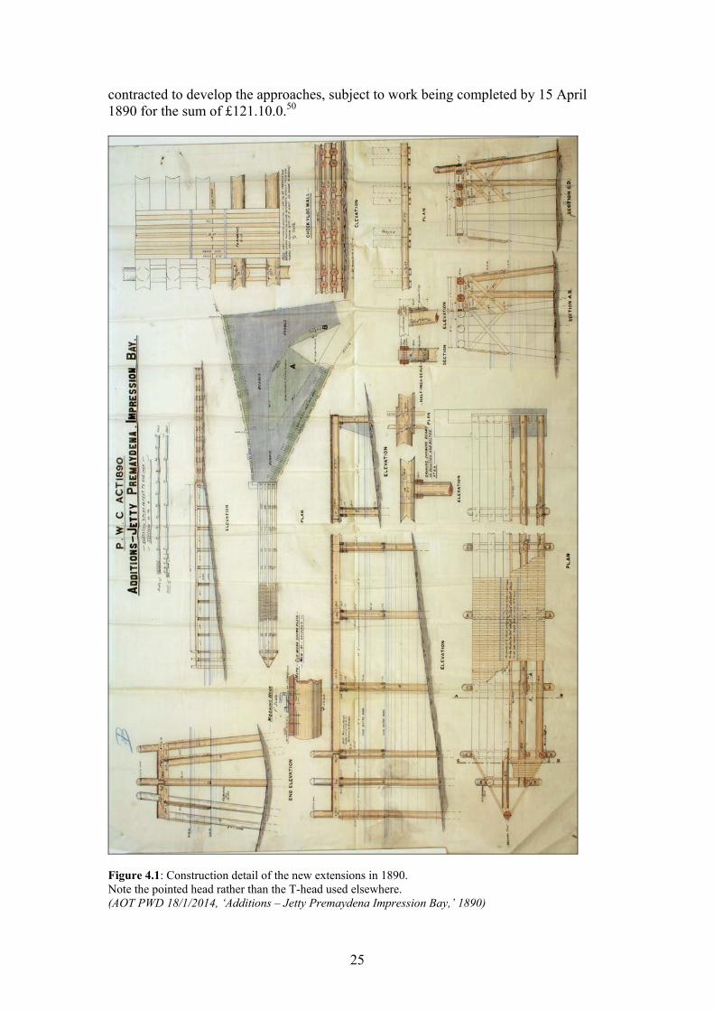
contracted to develop the approaches, subject to work being completed by 15 April 1890 for the sum of £121.10.0.50
Figure 4.1: Construction detail of the new extensions in 1890. Note the pointed head rather than the T-head used elsewhere. (AOT PWD 18/1/2014, ‘Additions – Jetty Premaydena Impression Bay,’ 1890)
25
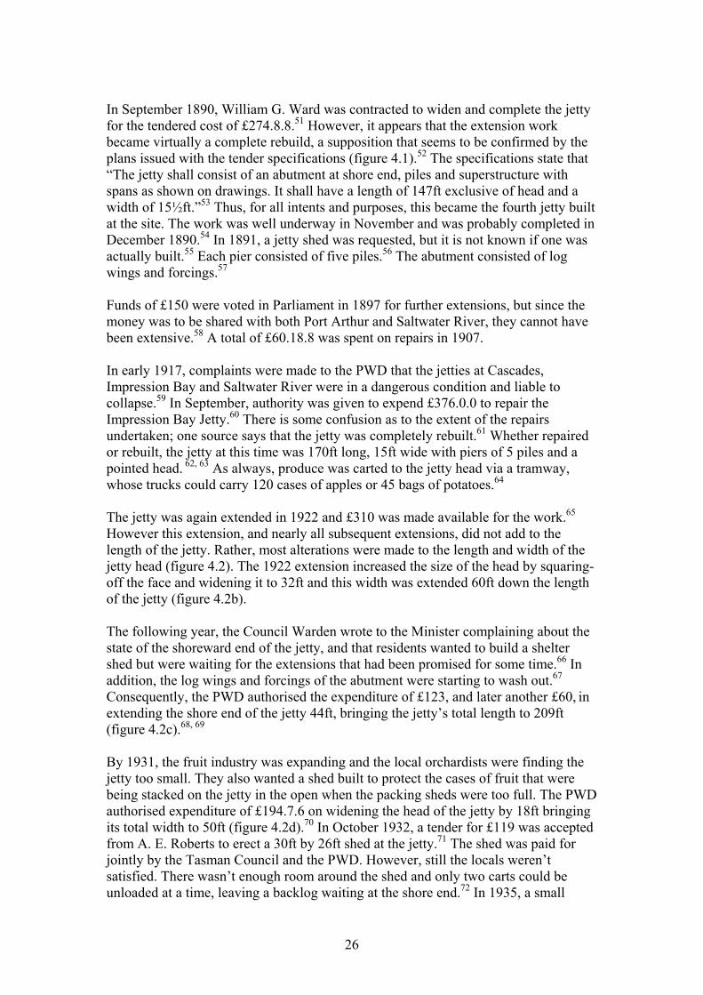
In September 1890, William G. Ward was contracted to widen and complete the jetty for the tendered cost of £274.8.8.51 However, it appears that the extension work became virtually a complete rebuild, a supposition that seems to be confirmed by the plans issued with the tender specifications (figure 4.1).52 The specifications state that “The jetty shall consist of an abutment at shore end, piles and superstructure with spans as shown on drawings. It shall have a length of 147ft exclusive of head and a width of 15½ft.”53 Thus, for all intents and purposes, this became the fourth jetty built at the site. The work was well underway in November and was probably completed in December 1890.54 In 1891, a jetty shed was requested, but it is not known if one was actually built.55 Each pier consisted of five piles.56 The abutment consisted of log wings and forcings.57 Funds of £150 were voted in Parliament in 1897 for further extensions, but since the money was to be shared with both Port Arthur and Saltwater River, they cannot have been extensive.58 A total of £60.18.8 was spent on repairs in 1907. In early 1917, complaints were made to the PWD that the jetties at Cascades, Impression Bay and Saltwater River were in a dangerous condition and liable to collapse.59 In September, authority was given to expend £376.0.0 to repair the Impression Bay Jetty.60 There is some confusion as to the extent of the repairs undertaken; one source says that the jetty was completely rebuilt.61 Whether repaired or rebuilt, the jetty at this time was 170ft long, 15ft wide with piers of 5 piles and a pointed head. 62, 63 As always, produce was carted to the jetty head via a tramway, whose trucks could carry 120 cases of apples or 45 bags of potatoes.64 The jetty was again extended in 1922 and £310 was made available for the work.65 However this extension, and nearly all subsequent extensions, did not add to the length of the jetty. Rather, most alterations were made to the length and width of the jetty head (figure 4.2). The 1922 extension increased the size of the head by squaring-off the face and widening it to 32ft and this width was extended 60ft down the length of the jetty (figure 4.2b). The following year, the Council Warden wrote to the Minister complaining about the state of the shoreward end of the jetty, and that residents wanted to build a shelter shed but were waiting for the extensions that had been promised for some time.66 In addition, the log wings and forcings of the abutment were starting to wash out.67 Consequently, the PWD authorised the expenditure of £123, and later another £60, in extending the shore end of the jetty 44ft, bringing the jetty’s total length to 209ft (figure 4.2c).68, 69 By 1931, the fruit industry was expanding and the local orchardists were finding the jetty too small. They also wanted a shed built to protect the cases of fruit that were being stacked on the jetty in the open when the packing sheds were too full. The PWD authorised expenditure of £194.7.6 on widening the head of the jetty by 18ft bringing its total width to 50ft (figure 4.2d).70 In October 1932, a tender for £119 was accepted from A. E. Roberts to erect a 30ft by 26ft shed at the jetty.71 The shed was paid for jointly by the Tasman Council and the PWD. However, still the locals weren’t satisfied. There wasn’t enough room around the shed and only two carts could be unloaded at a time, leaving a backlog waiting at the shore end.72 In 1935, a small
26
extension was added to the head to allow more room in front of the shed (figure 4.2e), at a cost of about £41.73
Figure 4.2: The four extensions made to the jetty between 1922 and 1943. (AOT PWD 1/1/163, ‘Premaydena Jetty, Impression Bay: plan showing extensions and present jetty,’ 24 Jun 1943)
a)
b)
c)
d)
e)
Over the next 15 years the jetty received a substantial amount of repair work. A total of £2005 was spent to keep the jetty functional.74 In 1950, a Doctor D.B. Houston requested permission to erect davits on the jetty to sling an 11½ft boat. His request was granted on the proviso that the davits were erected on the eastern side of the neck of the jetty, about 30ft shorewards from where the head began to splay.75 In September 1955, the M.V. Naracoopa, which was a regular Norfolk Bay trading vessel, was unloading lime and one of the lorries carting the lime went through the decking.76 After thorough inspection, it was estimated that repairs would cost about
27
£1,200.77 Matters were made much worse only a short time later when, just before Christmas 1955, lime stored in the shed ready for Naracoopa was too much for the rotten timbers and that portion of the jetty collapsed.78 The estimated cost to repair now rose to £2,200, but as an immediate matter, £120 was authorised to salvage the shed.79 For some time there had been moves to encourage the Naracoopa to use Nubeena instead of Impression Bay, but the vessel master resisted this saying that there was not enough water at Nubeena at certain low tides. However, the PWD took further soundings at Nubeena and were satisfied that there was enough water. In addition the future of the lime industry at Maria Island looked uncertain, and consequently the PWD refused to spend such a large amount on repairs.80 Repairs to the damaged section of the jetty had still not been effected the following year when a local scallop fisherman requested permission to erect a small 12ft by 10ft shed on the head for splitting scallops.81 This request was approved on the condition the shed was removed at the close of that year’s scallop season.82 By 1959, the jetty was becoming derelict and regular shipping services had now ceased to use it, having transferred to Nubeena. A pile in the neck had collapsed and the jetty was deemed unsafe even for foot traffic. Accordingly, the Transport Commission gave its blessing to closing the jetty permanently.83 However, the jetty was not demolished until 1970 when C.C. Baily and Sons were contracted for $950.00.84
28
Chapter 5 Saltwater River Station
Establishment Following the introduction of the probation system in Van Diemen’s Land, Salt Water Creek (later Saltwater River) was the first labour station instituted on the Tasman Peninsula.1 It was established to grow wheat to be ground at the proposed Port Arthur flour mill.2 Port Arthur’s commandant, Charles O’Hara Booth, had previously recommended the site to Governor Franklin as a potential station site.3 It was selected to take advantage of rich basaltic soils extending from the coast inland for 2.5km.4 Progress on the station was rapid. Only 10 months after the station was settled, there were roads, piers, land cleared and more than 50 acres ‘…luxuriantly cropped with cabbages, potatoes, turnips, etc.’5 In January 1842 there were described as being about 400 convicts and 14 soldiers of the 96th Regiment.6 However, the statistical returns for 1842-43 show that there were only 346 men at Saltwater River.7 By 1847 there were 499 prisoners at the station.8 The first buildings at the station were bark and slab huts, although by early 1842, there were ‘extensive penitentiaries’. 9, 10 The buildings were sited at the base of a rocky headland overlooking the bay but even by 1848, the accommodation buildings were still described as of a temporary nature, with no separate ‘apartments’. 11, 12 Dormitories were opened up and provided with bed-places divided by battens. By 1847, it was recognised that extensive upgrading was required. Plans were drawn up but little was implemented.13 However, the first bark and slab huts had at least been replaced by brick buildings.14 It was just as well, because the station, along with Cascades and Impression Bay, was required to help accommodate 100 of the 600 convicts from Norfolk Island.15 In 1852 Saltwater River, Cascades and Impression Bay convict stations were proclaimed by Executive Council as “Houses of correction for the reception and punishment of transported and other male and female convicts.”16 Saltwater River station was closed during the early 1850s after the scrapping of the probation system and the cessation of transportation to Van Diemen’s Land. In 1860 the land was being leased to a Mr Evenden who kept cattle there, as well as doing some cropping.17 However, that year, the government resumed control of the land from Mr Evenden for £426.5.0, and it became one of Port Arthur’s principal farm/outstations until the 1870s.18, 19 However, the number of prisoners was much reduced from the station’s heyday. In 1863 there were only 47 prisoners working at the farm.20
Operations There is very little documentary explanation of the operations at Saltwater River unearthed at this time. Cropping was the main source of employment for prisoners at the station. In the station’s early years, tilling was a manual affair, with little in the
29
way of machinery of any description; the spade and hoe were the main tools used.21 Bullocks were used from 1846 onwards. Apart from cultivation of crops, La Trobe alludes to subsidiary industries at the station when he states that shells for lime were easily procured, and that timber and clay were abundant.22 Lime, timber and clay would have enabled the station to be self-sufficient. From around the middle of 1847, sheep were run at a new farm established a few kilometres away from the station. In May of that year, 50 prisoners were employed in erecting fences and huts for the new sheep farm.23 As with all the probation stations, produce was transported to the jetty via a tramway and loaded aboard waiting vessels for export. It seems that the steamer Derwent was a regular visitor to Saltwater River, usually bypassing the nearby Coal Mines.24 Saltwater River was to be one of the more remunerative Peninsula probation stations, its agricultural produce supplying the rest of the peninsula. This was despite its siting far from the best ground and the brackish tidal influx.25
Maritime Infrastructure Convicts constructed the first jetty at Saltwater River in 1842. Guiler (1998:165) states that the structure was a long timber jetty with a stone abutment at the shore end, and that stone abutment remnants were still evident in 1995.26 However, there is no known documentary evidence that the original convict jetty actually had a stone abutment. The stone abutment remains at the site conform to the plans (figure 5.1) of a third-generation rebuild of the jetty in 1886-7 (see below). The jetty appears to have been about 396ft long, and was described as “out of repair” in 1872, but was still evident on Smith’s survey plan in 1876.27 The timber piles were still standing in 1885, when it was modified to conform to the new jetty built that year.28 However, plans for the new 1886 abutment state that the new walls were to be built “outside the present filling,” suggesting that there was originally some kind of walled, filled-in structure.29 In 1883, Parliament voted £300 to construct a new jetty, and in 1884 a portion of £400 (also for jetties at Gardner’s Bay, Franklin, Kingston and Beauty Point) increased the amount available. 30, 31 In January 1884, the Member for Sorell, James Gray, on behalf of constituents at Saltwater River, complained to the Minister asking why the government had been so slow in calling tenders despite the fact that the funds were available.32 The Minister’s reply indicated that this jetty was not considered a high priority.33 The specifications for the new jetty, which were developed in August 1884, raise interesting questions as to its configuration and relationship to the old one. The contractor was told to run the new jetty out 200ft and raise the old jetty (for its 396ft length) to 8ft above low water so that it conformed to the new jetty.34 It appears that
30
the new jetty was an extension of the old one, the length now being about 650ft.35 The 1884 specifications make no mention of construction of a new abutment, so it may be conjectured that the existing abutment from the convict jetty was still considered serviceable. The following October (1884) William Andrews of Harrington Street, Hobart, was contracted to construct the jetty for £298.0.0, to be completed by 18 March 1885.36
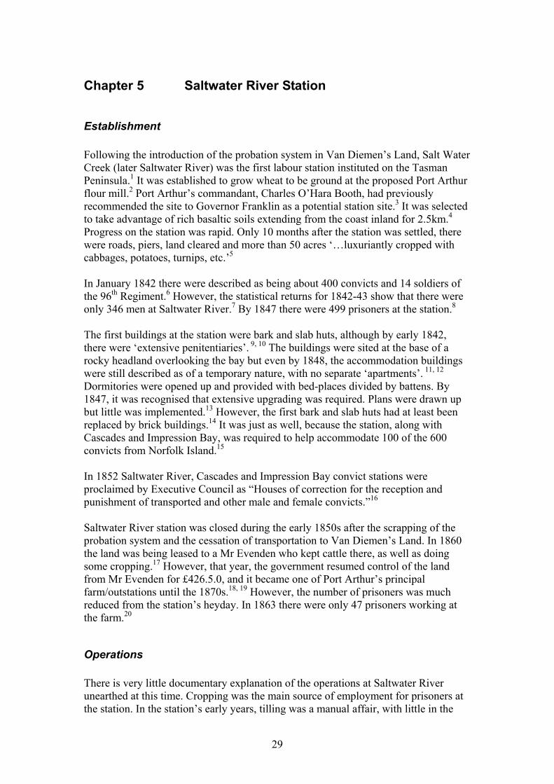
Figure 5.1: Plans for the new stone abutment for Saltwater River jetty, built 1886. (AOT PWD 18/1/841, ‘Jetty Saltwater River extension and completion: abutment on shore end,’ c.1886.) However, in 1885 a further £250 was voted for extension and completion of the jetty and approaches.37 In September 1886 three tenders were received for completion of the jetty: William Oates (£134), Messrs Lamb and Runney (£245) and William Andrews (£247).38 It appears that Oates initially won the contract with his extraordinarily low offer, but he later withdrew citing a misunderstanding of the terms of the specifications, and forfeited his £5 deposit.39 The second-placed tenderers, Henry Lamb and Walter Runney, thus gained the contract for £245 (subject to deductions to the extent of £40 as arranged by the Inspector) to be completed by 6 March 1887.40
31
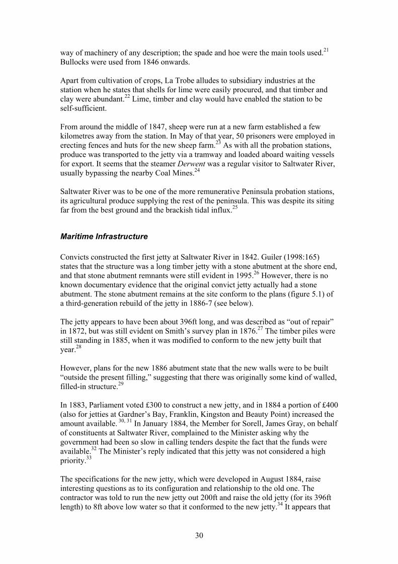
The specifications for this work included the construction of a substantial stone abutment, 83ft long on the western side, 44ft long on the eastern side with a wide-angled kick-back. It was to be 15ft wide at the end (figure 5.1).41 This arrangement conforms to the remains on site today. Interestingly, the stone used by Messrs Lamb and Runney was taken from a ruined and collapsed wall at the Coal Mines. They had written to the Minister seeking permission to do so, and the local PWD Inspector, Robinson, recommended approval as “there cannot possibly be any objection to [the Coal Mines] stone being allowed [to be used by the contractors].”42 Thus, not only did a piece of Government-sanctioned vandalism occur at the Coal Mines, but Lamb and Runney also gained financial favour in using free stone even though they had tendered to supply it at their expense.
Figure 5.2: The jetty at Saltwater River, looking back towards the Superintendent's house, probably c.1880s. Note the iron tram rails and chairs, and the fence on the western side. (AOT 30/5425, ‘Salt Water River,’ n.d.) In September 1898, Reverend B.W. Woolnough wrote to the PWD, on behalf of Saltwater River residents, requesting that the jetty be extended due to the inability of steamers berthing when winds blew hard from the north east.43 Nothing much was done until February 1900, when the Chief Inspector of Roads recommended that the jetty be extended “over old piles which are very dangerous at low tides and North to Westerly winds.”44 This implies that the current jetty was shorter than a previous incarnation, and that the piles of the previous one were still in situ. In mid-1900, M. Flynn and Co. were contracted to carry out the extension and by December the work had been completed for a cost of £150.0.0.45 Plans for the extension were not available in the files and it is not known how long the extension was. However, one letter mentioned an extension of 20ft.46 However, other evidence suggests an extension of five bays, which would equate to about 100ft.47
32
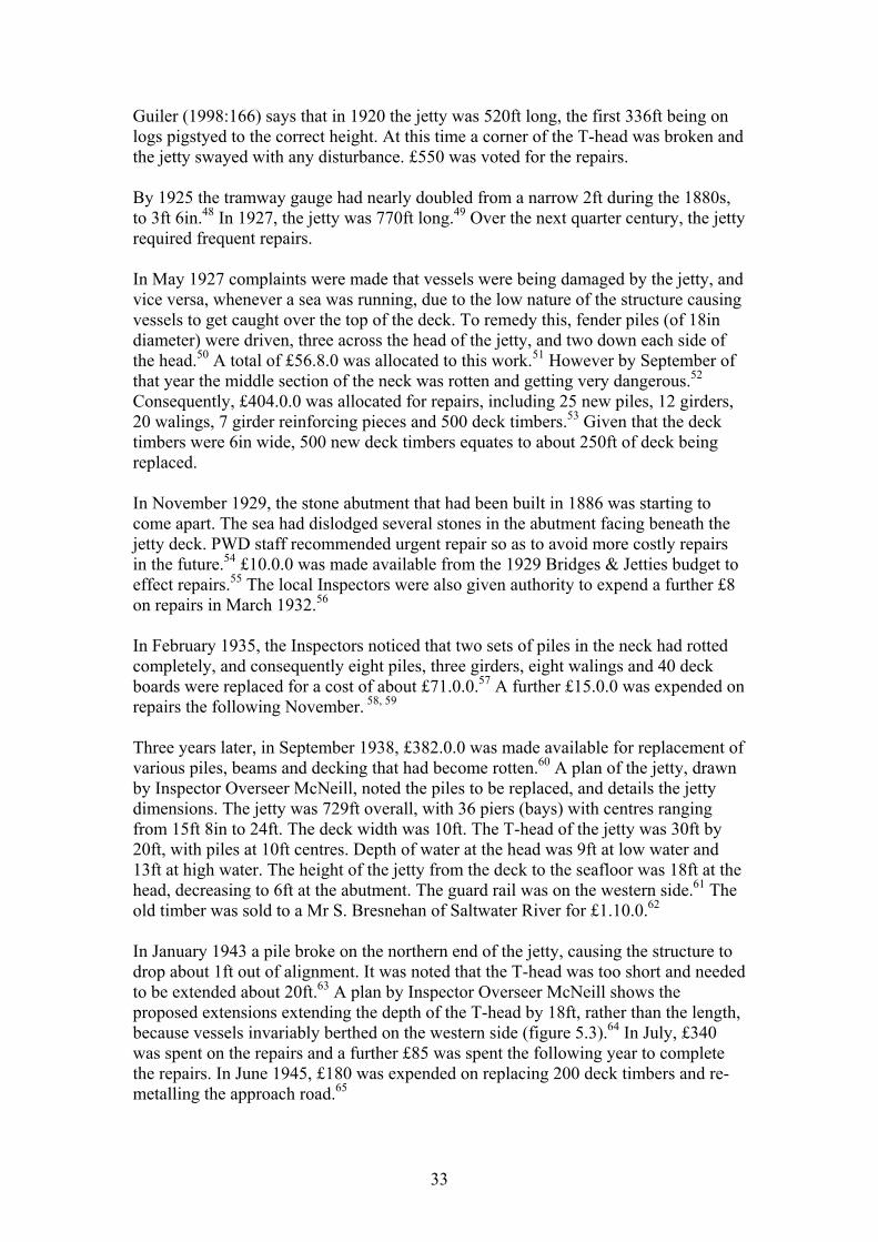
Guiler (1998:166) says that in 1920 the jetty was 520ft long, the first 336ft being on logs pigstyed to the correct height. At this time a corner of the T-head was broken and the jetty swayed with any disturbance. £550 was voted for the repairs. By 1925 the tramway gauge had nearly doubled from a narrow 2ft during the 1880s, to 3ft 6in.48 In 1927, the jetty was 770ft long.49 Over the next quarter century, the jetty required frequent repairs. In May 1927 complaints were made that vessels were being damaged by the jetty, and vice versa, whenever a sea was running, due to the low nature of the structure causing vessels to get caught over the top of the deck. To remedy this, fender piles (of 18in diameter) were driven, three across the head of the jetty, and two down each side of the head.50 A total of £56.8.0 was allocated to this work.51 However by September of that year the middle section of the neck was rotten and getting very dangerous.52 Consequently, £404.0.0 was allocated for repairs, including 25 new piles, 12 girders, 20 walings, 7 girder reinforcing pieces and 500 deck timbers.53 Given that the deck timbers were 6in wide, 500 new deck timbers equates to about 250ft of deck being replaced. In November 1929, the stone abutment that had been built in 1886 was starting to come apart. The sea had dislodged several stones in the abutment facing beneath the jetty deck. PWD staff recommended urgent repair so as to avoid more costly repairs in the future.54 £10.0.0 was made available from the 1929 Bridges & Jetties budget to effect repairs.55 The local Inspectors were also given authority to expend a further £8 on repairs in March 1932.56 In February 1935, the Inspectors noticed that two sets of piles in the neck had rotted completely, and consequently eight piles, three girders, eight walings and 40 deck boards were replaced for a cost of about £71.0.0.57 A further £15.0.0 was expended on repairs the following November. 58, 59 Three years later, in September 1938, £382.0.0 was made available for replacement of various piles, beams and decking that had become rotten.60 A plan of the jetty, drawn by Inspector Overseer McNeill, noted the piles to be replaced, and details the jetty dimensions. The jetty was 729ft overall, with 36 piers (bays) with centres ranging from 15ft 8in to 24ft. The deck width was 10ft. The T-head of the jetty was 30ft by 20ft, with piles at 10ft centres. Depth of water at the head was 9ft at low water and 13ft at high water. The height of the jetty from the deck to the seafloor was 18ft at the head, decreasing to 6ft at the abutment. The guard rail was on the western side.61 The old timber was sold to a Mr S. Bresnehan of Saltwater River for £1.10.0.62 In January 1943 a pile broke on the northern end of the jetty, causing the structure to drop about 1ft out of alignment. It was noted that the T-head was too short and needed to be extended about 20ft.63 A plan by Inspector Overseer McNeill shows the proposed extensions extending the depth of the T-head by 18ft, rather than the length, because vessels invariably berthed on the western side (figure 5.3).64 In July, £340 was spent on the repairs and a further £85 was spent the following year to complete the repairs. In June 1945, £180 was expended on replacing 200 deck timbers and re-metalling the approach road.65
33
By 1950 the future of the jetty was in doubt, and although steamers were expected to keep using the structure for some time, any further expenditure was to be limited to basic maintenance to keep it safe for a further two years.66 Accordingly, £410 was spent to replace some piles and decking.67 In June 1952, the Department of Transport decided to close and demolish the jetty and requested that the PWD make arrangements.68 By July 1953 tenders were received for the demolition, but the PWD decided not to proceed until the Randall’s Bay and Taranna jetties had been demolished.69 Government bureaucracies are notorious for moving slowly and this case was no exception. Seventeen years elapsed before C.C. Bailey and Sons finally demolished the jetty for $833.90 in 1970.70
Figure 5.3: Plans for the head extension at Saltwater River jetty in 1943. The plans call for placing two 18’ x 10’ fillers in the neck of the ‘T’, giving the quay dimensions of 30’ x 38’. (AOT AD 266/1/815, N. McNeill, ‘Saltwater River Jetty proposed extension,’ 22 February 1943.)
34
Chapter 6 Summary of maritime infrastructure
Cascades Station
Jetty 1 Date constructed: late-1841 to early-1842 (possibly still under construction 1846) Date demolished: 1870s? Location: On the headland on the western side of the bay. Configuration: Straight with (a T-head?) Dimensions:
Length: Unrecorded Width: Unrecorded Height: Unrecorded
Construction details: Unrecorded. Associated infrastructure: Tramway from sawmill; terminal retaining wall; jetty shed. Comments: Remains of a jetty were still standing in 1876 (figure 2.2), but it is not known if it depicts this jetty or the ‘Old Jetty’ (Jetty 2 below).
Jetty shed Date constructed: Unknown Date demolished: Unknown Location: On the headland on the northern side of the bay, near the jetty (refer figure 2.4). Dimensions:
Length: Unrecorded Width: Unrecorded Height: Unrecorded
Construction details: Unrecorded. Comments: There is one reference to the existence of a shed near the jetty, where timber was sometimes stored awaiting shipment.
Tramway Date constructed: pre-1851? Date demolished: Unknown Location: On the headland on the western side of the bay, near the jetty, to the sawmill to the south of the settlement (refer figure 2.1). Dimensions:
Length: Unrecorded Width: Unrecorded Height: Unrecorded
Construction details: Unrecorded, but probably using iron rails and rail chairs similar to those used at Saltwater River, rather than timber like those at the coal mines. Comments: The tramway bypassed the settlement on the western side, circling around the curve of the bay and then turning sharply south west.
35
Ballast dump The existence of a formal ballast dumping area has not been recorded, however it appears that ballast was simply dumped when vessels were alongside the jetty.
Jetty 2 (The Old Jetty) Date constructed: 1850s-60s? Date demolished: after 1888. Location: As above. Configuration: Unknown. Dimensions:
Length: Unrecorded Width: Unrecorded Height: Unrecorded
Construction details: Unrecorded. Associated infrastructure: Tramway; terminal retaining wall; jetty shed. Comments: Little is known of this jetty.
Jetty 3 Date constructed: 1884, extended 1885, 1895 (see below). Date demolished: N/A Location: As above. Configuration: Straight with a T-head. Dimensions: Jetty Neck Jetty Head
Length: 351’ 6” Unrecorded Width: 12’ Unrecorded Height: 7’ (shore) to 12’ (head) above HW
Construction details: All timbers were of blue gum or stringybark; 11 of the piers had 3 piles (outside piles driven to a batter of 1 in 6). Four of the piles were mooring piles and extended 4’ above deck level. Seven of the piers (shore end) formed trestles that had piles resting on 24” diameter bedlogs, which themselves rested upon three 18” x 9” half round sleeper logs (round side up). Sawn timbers consisted of 10” x 4” walings, 9” x 4” diagonal braces, and 15” x 6” girders. The deck consisted of 6” x 4” x 12’ planks. The fence consisted of 4” x 5” posts, 4” x 4” top rails, 3” x 2” bottom rails and 3” x 2” stays. Associated infrastructure: Tramway; terminal retaining wall; jetty shed. Comments: The plans drawn by Robinson called for a 400’ x 18’ jetty. However, the contract specifications called for somewhat reduced dimensions.
Jetty 3A Date constructed: 1885 (an extension of Jetty 2 above). Date demolished: N/A Location: As above. Configuration: Straight with a T-head. Dimensions: Jetty Neck Jetty Head
Length: 551’ 9½” (200’ 3½” extension) Unrecorded Width: 12’ Unrecorded Height: 7’ above HW
36
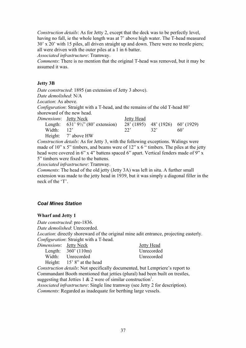
Construction details: As for Jetty 2, except that the deck was to be perfectly level, having no fall, ie the whole length was at 7’ above high water. The T-head measured 30’ x 20’ with 15 piles, all driven straight up and down. There were no trestle piers; all were driven with the outer piles at a 1 in 6 batter. Associated infrastructure: Tramway. Comments: There is no mention that the original T-head was removed, but it may be assumed it was.
Jetty 3B Date constructed: 1895 (an extension of Jetty 3 above). Date demolished: N/A Location: As above. Configuration: Straight with a T-head, and the remains of the old T-head 80’ shoreward of the new head. Dimensions: Jetty Neck Jetty Head
Length: 631’ 9½” (80’ extension) 28’ (1895) 48’ (1926) 60’ (1929) Width: 12’ 22’ 32’ 60’ Height: 7’ above HW
Construction details: As for Jetty 3, with the following exceptions. Walings were made of 10” x 5” timbers, and beams were of 12” x 6 “ timbers. The piles at the jetty head were covered in 6” x 4” battens spaced 6” apart. Vertical fenders made of 9” x 5” timbers were fixed to the battens. Associated infrastructure: Tramway. Comments: The head of the old jetty (Jetty 3A) was left in situ. A further small extension was made to the jetty head in 1939, but it was simply a diagonal filler in the neck of the ‘T’.
Coal Mines Station
Wharf and Jetty 1 Date constructed: pre-1836. Date demolished: Unrecorded. Location: directly shoreward of the original mine adit entrance, projecting easterly. Configuration: Straight with a T-head. Dimensions: Jetty Neck Jetty Head
Length: 360’ (110m) Unrecorded Width: Unrecorded Unrecorded Height: 15’ 8” at the head
Construction details: Not specifically documented, but Lempriere’s report to Commandant Booth mentioned that jetties (plural) had been built on trestles, suggesting that Jetties 1 & 2 were of similar construction1. Associated infrastructure: Single line tramway (see Jetty 2 for description). Comments: Regarded as inadequate for berthing large vessels.
37
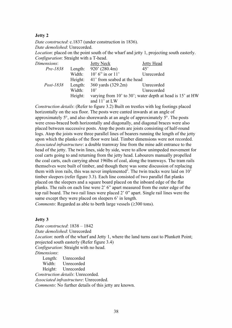
Jetty 2 Date constructed: c.1837 (under construction in 1836). Date demolished: Unrecorded. Location: placed on the point south of the wharf and jetty 1, projecting south easterly. Configuration: Straight with a T-head. Dimensions: Jetty Neck Jetty Head
Pre-1838 Length: 920’ (280.4m) 45’ Width: 10’ 6” in or 11’ Unrecorded Height: 41’ from seabed at the head Post-1838 Length: 360 yards (329.2m) Unrecorded
Width: 10’ Unrecorded Height: varying from 10’ to 30’; water depth at head is 15’ at HW
and 11’ at LW Construction details: (Refer to figure 3.2) Built on trestles with log footings placed horizontally on the sea floor. The posts were canted inwards at an angle of approximately 5°, and also shorewards at an angle of approximately 5°. The posts were cross-braced both horizontally and diagonally, and diagonal braces were also placed between successive posts. Atop the posts are joists consisting of half-round logs. Atop the joists were three parallel lines of bearers running the length of the jetty upon which the planks of the floor were laid. Timber dimensions were not recorded. Associated infrastructure: a double tramway line from the mine adit entrance to the head of the jetty. The twin lines, side by side, were to allow unimpeded movement for coal carts going to and returning from the jetty head. Labourers manually propelled the coal carts, each carrying about 196lbs of coal, along the tramways. The tram rails themselves were built of timber, and though there was some discussion of replacing them with iron rails, this was never implemented2. The twin tracks were laid on 10’ timber sleepers (refer figure 3.3). Each line consisted of two parallel flat planks placed on the sleepers and a square board placed on the inboard edge of the flat planks. The rails on each line were 2’ 6” apart measured from the outer edge of the top rail board. The two rail lines were placed 2’ 0” apart. Single rail lines were the same except they were placed on sleepers 6’ in length. Comments: Regarded as able to berth large vessels (≥300 tons).
Jetty 3 Date constructed: 1838 – 1842 Date demolished: Unrecorded Location: north of the wharf and Jetty 1, where the land turns east to Plunkett Point; projected south easterly (Refer figure 3.4) Configuration: Straight with no head. Dimensions:
Length: Unrecorded Width: Unrecorded Height: Unrecorded
Construction details: Unrecorded. Associated infrastructure: Unrecorded. Comments: No further details of this jetty are known.
38
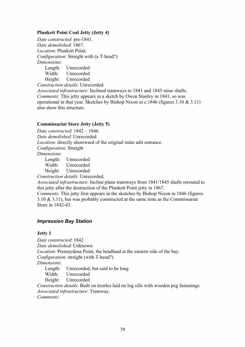
Plunkett Point Coal Jetty (Jetty 4) Date constructed: pre-1841. Date demolished: 1867. Location: Plunkett Point. Configuration: Straight with (a T-head?) Dimensions:
Length: Unrecorded Width: Unrecorded Height: Unrecorded
Construction details: Unrecorded. Associated infrastructure: Inclined tramways to 1841 and 1845 mine shafts. Comments: This jetty appears in a sketch by Owen Stanley in 1841, so was operational in that year. Sketches by Bishop Nixon in c.1846 (figures 3.10 & 3.11) also show this structure.
Commissariat Store Jetty (Jetty 5) Date constructed: 1842 – 1846. Date demolished: Unrecorded Location: directly shoreward of the original mine adit entrance. Configuration: Straight Dimensions:
Length: Unrecorded Width: Unrecorded Height: Unrecorded
Construction details: Unrecorded. Associated infrastructure: Incline plane tramways from 1841/1845 shafts rerouted to this jetty after the destruction of the Plunkett Point jetty in 1867. Comments: This jetty first appears in the sketches by Bishop Nixon in 1846 (figures 3.10 & 3.11), but was probably constructed at the same time as the Commissariat Store in 1842-43.
Impression Bay Station
Jetty 1 Date constructed: 1842 Date demolished: Unknown Location: Premaydena Point, the headland at the eastern side of the bay. Configuration: straight (with T-head?) Dimensions:
Length: Unrecorded, but said to be long Width: Unrecorded Height: Unrecorded
Construction details: Built on trestles laid on log sills with wooden peg fastenings. Associated infrastructure: Tramway. Comments:
39
Jetty 2 Date constructed: Unknown, probably 1850s-1860s. Date demolished: Unknown, 1890s? Location: As above Configuration: straight (with T-head?) Dimensions:
Length: 102.5’ Width: Unknown Height: Unknown
Construction details: Built on sills on the rock platform. Sills were made from ~2’ diameter, 4.5’ long logs placed at 10’ centres. Notches 10” deep were cut into the sills to take the piles. Associated infrastructure: Comments: The approach and some piles were still extant in 1995.
Jetty 2A Date constructed: 1884-5 (an extension of Jetty 2 above). Date demolished: 1890 (extended and partially rebuilt as jetty 2B below). Location: As above Configuration: straight, with T-head. Dimensions: Jetty Neck Jetty Head
Length: 102.5’ Unknown Width: approx 8’ Unknown Height: 7’ at head above HW
Construction details: The land end of the jetty consisted of an abutment built of stone 18’ wide, 3’ thick at top and 6’ at bottom. The abutment was filled in with stone and levelled off on top. The timber jetty consisted of 6 spans: first one at shore end 19’, next two 18’ centres and the remaining three at 15’ centres. Timber was of blue gum or stringybark. Piles were not less than 15” diameter, and braced with 9” x 4” diagonal braces. Floor timbers were 6” x 3” sawn timbers, 8’ long suggesting the width of the jetty. A 2-rail fence ran down one side of the jetty, was painted a stone colour, and its ironwork picked out in blue. The head was planked down the sides to within 6” of LW. Associated infrastructure: Tramway and trolley? Comments:
Jetty 2B Date constructed: 1890 (an extension and widening of jetty 2A, and extended again in 1897) Date demolished: 1917 (completely rebuilt as jetty 3 below). Location: As above Configuration: straight, with T-head. Dimensions: Jetty Neck Jetty Head
Length: 147’ (exclusive of head) Unknown Width: 15.5’ Unknown Height:
Construction details: Timbers of blue gum, peppermint gum, stringybark or ironbark.
40
Associated infrastructure: Shed? Tramway and trolley. Comments: The records show the jetty was extended again in 1897, but the details were not recorded.
Jetty 3 Date constructed: 1917 (a rebuild of jetty 2B above). Date demolished: 1970. Location: As above Configuration: Straight, with various head shapes (resulting from extensions) Dimensions: Jetty Neck Jetty Head
1917 – 1924 1924 – 1950 1922 1931 Length: 170’ 209’ 32’ 50’ Width: 16’ 16’ 75’ 75’ Height: Unknown Unknown
Construction details: Not recorded. Associated infrastructure: Shed built in 1932 (30’ x 26’). Comments: The jetty head was not squared at 50’ x 75’ but splayed to only 45’ at its eastern side (refer figure 4.2)
Jetty 5 Date constructed: Unknown. Date demolished: Unknown. Location: Far side of the bay from the Government jetty. Configuration: Unknown. Dimensions:
Length: Unknown Width: Unknown Height: Unknown
Construction details: Not recorded. Associated infrastructure: Unknown. Comments: This was a private jetty and details are not known.
Saltwater River Station
Jetty 1 Date constructed: 1842. Date demolished: N/A Location: Configuration: Straight, but possibly with a T-head. Dimensions:
Length: 396’ Width: Unrecorded Height: Unrecorded
41
Construction details: Construction details are not recorded, but possibly built of trestles similar to the designs used at other stations. Associated infrastructure: Jetty 2 (from 1885). Comments: Guiler (1998:165) states that the stone remains and abutment fragments were still visible in 1995, but these are more likely to be from the 1886 abutment construction (see below).
Jetty 1A Date constructed: 1885 (an extension of Jetty 1) Date demolished: N/A Location: As above Configuration: Straight with a T-head. Dimensions:
Length: 650’ (200’ extension) Width: 2’ 9” Height: 8’ above LW
Construction details: Timber piles of 18” diameter, driven 9’ into the seafloor. Piles set at 18’ centres. Three piles at landward end, two piles elsewhere. All piles driven to a batter of 1 in 6. All timber of stringybark or peppermint gum. Top walings 8” x 4”, bottom walings 9” x 6”. Longitudinal braces 9” x 6”, diagonal braces 9” x 5”. Girders 15” x 6” throughout. Flooring 6” x 1.5” sawn planks. Deck lined with 8” x 4” sleepers, spaced 3’ apart, except at approach 2’ apart, to take tramway rails set a 2’ gauge. Rails at end of jetty turned up to stop trolley. The abutment was built of stone, 15’ wide, and 83’ long on the western side, 44’ on the eastern side with a dog-leg 48’ long. Built outside original filling. Abutment walls of dressed stone 6’ high, 2.5’ at base, 1.5’ at top (batter of 1’). Inside faces of wall tarred before filling with stone. Associated infrastructure: Jetty 1; Tramway and trolley. Comments: This is an extension to the original jetty 1, which was modified (raised in height) to conform to this new jetty.
Jetty 1B Date constructed: 1898 (an extension of Jetty 1A) Date demolished: 1970-71 Location: As above Configuration: Straight with a T-head. Dimensions: Jetty Head
Length: 770’ (120’ extension) Unknown (1898) 30’ (1926) 30’ (1943) Width: 2’ 9” – 10’ Unknown 20’ 38’ Height: 8’ above LW
Construction details: Unknown, but probably similar to Jetty 1A. Associated infrastructure: Tramway and trolley. Comments: The information on extensions at this point, are a little confusing. Sources give the following jetty lengths: 1920 (550’), 1927 (770’), 1938 (729’). By 1927 the jetty was 10’ with a rail gauge of 3.5’ :
42
References Brand, I., 1987. Penal coal: a history of the Port Arthur Coal Mines, Jason Publications, West Moonah, Victoria. Brand, I., 1990. The convict probation system: Van Diemen’s Land 1839-1854, Blubber Head Press, Hobart. Brand, I., 1998. Penal peninsula: Tasmania’s Port Arthur and its outstations 1827-1898, Regal Publications, Launceston. Brand, I., n.d. The Port Arthur Coal Mines 1833-1877, Regal Publications, Launceston. Broxam, G. & Nash, M., 1998. Tasmanian shipwrecks: volume 1797-1899, Navarine Publishing, Woden, ACT. Evans, K., 2000. Coal Mines Historic Research Project, Report for Parks and Wildlife Service. Guiler, E.R., 1998. Gone and almost forgotten: jetties in Southern Tasmania, Sandy Bay, Tasmania. Jackman, G., 2004. ‘The foetal shore,’ in: Tuffin, R. (ed.) A harbour large enough to admit a whole fleet: the maritime history and archaeology of Port Arthur. Occasional Paper No 1, Port Arthur Historic Site Management Authority, Port Arthur. McMahon, A., 1966. ‘The convict stations of Norfolk Bay,’ THRA Papers and Proceedings, May. Nicholson, I.H., 1985. Shipping arrivals and departures: Tasmania, Vol 2: 1834-1842. Roebuck Society, Canberra. NPWS, 1984. The Cascades Historic Conservation Area Draft Management Plan, National Parks and Wildlife Service, Hobart. PWS, 1997. Coal Mines Historic Site Management Plan, Parks and Wildlife Service, Hobart. Tuffin, R., 2004. ‘Cascades Probation Station: prison built on timber,’ Tasmanian Historical Research Association, 5(2).
43
44
End Notes
Chapter 1: Introduction 1 G. Jackman, 2004. ‘The foetal shore,’ in: Tuffin, R. (ed.) A harbour large enough
to admit a whole fleet: the maritime history and archaeology of Port Arthur. Occasional Paper No 1, Port Arthur Historic Site Management Authority, Port Arthur, p.12.
2 I. Brand, The convict probation system: Van Diemen’s Land 1839-1854, Blubber Head Press, Hobart 1990, p.1.
3 Brand, 1990, p.17. 4 Brand, 1990, p.225. 5 I. Brand, Penal peninsula: Tasmania’s Port Arthur and its outstations 1827-1898,
Regal Publications, Launceston, 1998, p.112. 6 Jackman, p.12. Chapter 2: Cascades Station 1 Jackman, p.18. 2 NPWS, The Cascades Historic Conservation Area Draft Management Plan,
National Parks and Wildlife Service, 1984. 3 R. Tuffin, ‘Cascades Probation Station: prison built on timber,’ Tasmanian
Historical Research Association, 5(2), June 2004, p.78. 4 Tuffin, p.75. 5 Tuffin, p.73. 6 Brand, 1998, p.73. 7 A. McMahon, ‘The convict stations of Norfolk Bay,’ THRA Papers and
Proceedings, May 1966, p.65. 8 ‘A despatch from C.J. La Trobe Esq. to Earl Grey: the present state and prospects
of the convicts in Van Diemen’s Land, 31 May 1847, in I. Brand, The convict probation system: Van Diemen’s Land 1839-1854, Blubber Head Press, Hobart 1990, p.185.
9 AOT GO 46/1, Comptroller General of Convicts to Lt Governor, 30 May 1848, p.179-180.
10 AOT Misc 62/34/A1141/21370, Comptroller General to Superintendent Cascades, 24 February 1855.
11 Hobart Town Gazette, 3 August 1852, p.624, in R. Lord, Impression Bay: convict probation station to civilian quarantine station, Richard Lord and Partners, Taroona, Tasmania, p.23.
12 AOT GO 46/3, Comptroller General of Convicts to Governor, 30 June 1857. 13 Lord, p.65. 14 Godfrey, D.G.A. Logden & D.K. Pears, The Koonya Well: an archaeological
investigation, research report, Department of Teacher Education, University of Tasmania, 1982, p.15, in The Cascades Historic Conservation Area Draft Management Plan, National Parks and Wildlife Service, 1984.
15 NPWS, 1984.
45
16 Mercury, 28 April 1903, p.3. 17 NPWS, 1984. 18 McMahon, p.65. 19 NPWS, 1984. 20 CO 280/199, p.280-281, Comptroller General of Convicts to Lt Governor, 1
August 1846, in Lord, p.20. 21 Tuffin, p.75. 22 Tuffin, p.76. 23 F. Mackie, Traveller under concern: the Quaker journals of Frederick Mackie on
his tour of the Australian Colonies, reprinted 1973, in Tuffin, p.75. 24 AOT Misc 64/34/A1141/21370, Note by Comptroller General, 14 February 1855. 25 Jackman, p.21. 26 La Trobe’s report, in Brand, 1990, p.134. 27 La Trobe’s report, in Brand, 1990, p.185. 28 Tuffin, p.76. 29 E.R. Guiler, Gone and almost forgotten: jetties in Southern Tasmania, Sandy Bay,
Tasmania, 1998, p.170. 30 AOT Misc 62/34/A1141/21370, Comptroller General to Superintendent Cascades,
24 February 1855. 31 AOT Misc 62/34/A1141/21370, Comptroller General to Superintendent Cascades,
24 February 1855. 32 AOT PWD 18/1/362, Inspector Robson to Minister for Lands and Works, 9 March
1888. 33 AOT Journal of the House of Assembly, 46 Vict. 24, 23 August 1882, p.126. 34 AOT PWD 18/1/362, Petition to Minister of Lands and Works, c.13 February
1883. 35 AOT PWD 18/1/362, Petition to Minister of Lands and Works, c.1 August 1883. 36 AOT PWD 18/1/362, District Inspector of Roads to Engineer-in-Chief, 6 February
1883. 37 AOT PWD 18/1/362, Engineer-in-Chief to Contractor, 19 March 1884. 38 AOT PWD 18/1/362, District Inspector of Roads to Engineer of Roads, 19 April
1884. 39 AOT PWD 18/1/362, Proposed jetty, Cascades, Tasman’s Peninsula, 6 February
1883. 40 AOT PWD 18/1/362, District Inspector of Roads to Engineer-in-Chief, 8 July
1884. 41 AOT Journal of the House of Assembly, 48 Vict. 36, 24 September 1884, p.200. 42 AOT PWD 18/1/650, Contract for extension of Cascades jetty, 10 April 1885. 43 AOT PWD 18/1/650, Specifications for extension of Cascades jetty, 13 February
1885. 44 AOT Journal of the House of Assembly, 49 Vict. 45, 1885, p.139. 45 AOT Journal of the House of Assembly, 55 Vict. 37, 15 September 1891, p.170. 46 AOT PWD 18/1/2862, Contract for extension of Cascades Jetty, 8 October 1895. 47 AOT PWD 18/1/2862, James R, McClymont declaration, 5 June 1896. 48 AOT PWD 18/1/2862, Governor’s Proclamation, 23 March 1897. 49 AOT AD 266/1/814, Secretary for Public Works to Inspector Hobden, 6 July 1926. 50 AOT AD 266/1/814, Inspector Hobden to Secretary for Public Works, 27 July
1926.
46
51 AOT AD 266/1/814, Secretary for Public Works to Inspector Hobden, 26
December 1926. 52 AOT AD 266/1/814, Inspector Hobden to Secretary for Public Works, 15
November 1929. 53 AOT AD 266/1/814, Council Clerk to Director of Public Works, 31 October 1931. 54 AOT AD 266/1/814, Director of Public Works to Inspector Hobden, 15 December
1931. 55 AOT AD 266/1/814, Inspector Hobden to Director of Public Works, 16 April
1934. 56 AOT AD 266/1/814, Council Clerk to Director of Public Works, 30 July 1934. 57 AOT AD 266/1/814, Overseer McNeill to Bridge Engineer, 28 June 1939. 58 AOT AD 266/1/814, Bridge Engineer to Inspector Hobden, 7 July 1939. 59 AOT AD 266/1/814, Petition to Minister for Lands and Works, 17 July 1943. 60 AOT AD 266/1/814, Minister for Lands and Works to Mr T.J. McKinley MHA, 3
November 1943. 61 AOT AD 266/1/814, Commissioner for Transport to Director of Public Works, 21
June 1944. 62 AOT AD 266/1/814, Transport Commission Expenditure Authority No. 50, 17
November 1944. 63 AOT Tasmania Journals and Papers of Parliament, Director of Public Works
Report for year 1949 – 1950, 14 George VI 45, p.9. 64 AOT AD 266/1/814, Bridge Engineer to District Engineer, S.E., 20 October 1950. 65 AOT AD 266/1/814, Construction Engineer to Bridge Engineer, 12 October 1953. 66 AOT AD 266/1/814, Secretary of Public Works to Mr A.B. Clark, 10 December
1954. 67 P. Adam-Smith, There was a ship, Nelson, Melbourne, 1983. 68 Guiler, p.174. Chapter 3: Coal Mines Station 1 K. Evans, Coal Mines Historic Research Project, Report for Parks and Wildlife
Service, 2000, p.14. 2 Jackman, p.36. 3 I. Brand, Penal coal: a history of the Port Arthur Coal Mines, Jason Publications,
West Moonah, 1987, in Evans, p.14. 4 Coal Mines Historic Site Management Plan, Parks and Wildlife Service, 1997, p.8. 5 Lord, p.29. 6 Evans, pp.28-29. 7 AB951, Tasman Council Correspondence, in Evans, p.29. 8 Evans, p.29. 9 Leases 27/93M, 400/93M & 32/93M, Mines Department Lease Records, in Evans,
pp.29-30. 10 Evans, p.35. 11 PWS, Coal Mines Historic Site Management Plan, Parks and Wildlife Service,
1997, p.5. 12 G. Jackman, Archaeology Manager, Port Arthur Historic Site Management
Authority, pers. comm. 13 Jackman, p.17.
47
14 M. Pearson & B. McGowan, Mining Heritage Places Assessment Manual (draft),
1998, in Evans, p.14. 15 AOT CO 280/549, Dr JB Motherwell to Comptroller General of Convicts, 10 June
1846, p.512. 16 PWS, p.7. 17 Hobart Town Courier, 13 February 1835, in I.H. Nicholson, Shipping arrivals and
departures: Tasmania, Vol 2: 1834-1842. Roebuck Society, Canberra, 1985, p.30. 18 Pearson & McGowan, p.107, in Evans, p.14. 19 Jackman, p.17. 20 I. Brand, The Port Arthur Coal Mines 1833-1877, Regal Publications, Launceston,
n.d., p.11. 21 C. Bacon, ‘The coal resources of Tasmania,’ Geological Survey Bulletin 64,
Division of Mines and Mineral Resources, Department of Resources and Energy, Hobart, 1991, p.156, in Evans, p.15.
22 Jackman, p.17. 23 PWS, p.7. 24 Evans, p.16. 25 PWS, p.7. 26 Evans, p.16. 27 PWS, p.7. 28 AOT CSO 22/59/909, Superintendent William Dawson to Principal Superintendent
of Convicts, 21 July 1842, in Jackman p.17. 29 Evans, p.21. 30 PWS, p.8. 31 PWS, p.8. 32 Evans, p.29. 33 AOT CSO 5/72/1584, Lhotsky to Commandant, The mining establishment Coal
Point, 20 March 1837. 34 Hobart Town Courier, 31 March 1836, in I.H. Nicholson, Shipping arrivals and
departures: Tasmania, Vol 2: 1834-1842. Roebuck Society, Canberra, 1985, p.58. 35 AOT NS 279/1/1, Journal of Lady Jane Franklin, 22 March 1837, in Brand, 1987,
p.17, in Evans, p.51. 36 AOT NS 279/1/1, Journal of Lady Jane Franklin, 22 March 1837, in Brand, 1987,
p.17, in Evans, p.51. 37 Brand, 1987, p.26, in Evans, p.52. 38 T.J. Lempriere, ‘The penal settlements of early Van Diemen’s Land,’ 1839,
reprinted by Royal Society of Tasmania (Northern Branch), 1954, p.79. 39 AOT ML31, Probation Station ‘Coal Point’ Tasman Peninsula, n.d. 40 Evans, p.63. 41 Evans, p.22. 42 NLA R4964/1-2, Conrad Martens, ‘The Coal Mines, Tasman Peninsula,’ n.d. 43 AOT Misc 62/17, Captain Hadden to Commanding Royal Engineer, 20 May 1847. 44 MM62/21/A1115/7370, in Brand, 1987, p.112, cited in Evans, p.62. 45 Anonymous, ‘A trip to the mines,’ The Mercury, 1858. 46 Brand, n.d., p.86. 47 Brand, n.d., p.86. 48 Pembroke 76 Central Plan Office, Plan of Port Arthur Coal Mines, 1875, in Evans,
figure 42. 49 Brand, n.d., p.86.
48
Chapter 4: Impression Bay Station 1 Jackman, p.18. 2 AOT CSO 22/8/290.1, Colonial Secretary to Director of Probation System, 2
October 1841. 3 AOT CSO 22/8/290, p.183, Director of Probation System to Lt Governor, 24
September 1841. 4 AOT CSO 22/8/290, p.183. 5 La Trobe’s report, in Brand, 1990, p.192. 6 AOT GO 46/1, Comptroller General of Convicts to Lt Governor, 30 May 1848,
p.181-183. 7 AOT GO 46/1, Comptroller General of Convicts to Lt Governor, 30 May 1848,
p.181-183. 8 Jackman, p.19. 9 Lord, p.29. 10 Hobart Town Gazette, 3 August 1852, p.624, in Lord, p.23. 11 Diary of Frederick Mackie, 22 December 1853, in: M. Nicholls (ed.), Traveller
under concern, the Quaker journals of Frederick Mackie on his tour of the Australian colonies 1852-1855, University of Tasmania, 1973, p.159, in Lord, p.23.
12 AOT GO 46/3, Comptroller General of Convicts to Governor, 30 June 1857. 13 Lord, p.29. 14 AOT CSD 1/162 4327, Executive Council Meeting, 3 November 1857. 15 Jackman, p.19. 16 Lord, p.2. 17 AOT GO 33/52, p.297, Comptroller General of Convicts to Lt Governor, 21 July
1845, p.295. 18 AOT GO 33/52, p.295, Comptroller General of Convicts to Lt Governor, 21 July
1845, p.295. 19 Jackman, p.18. 20 AOT GO 33/52, p.297, Comptroller General of Convicts to Lt Governor, 21 July
1845, in Lord, pp.14 -15. 21 CO 280/199, Comptroller General of Convicts to Lt Governor, 1 August 1846,
p.280-281. 22 AOT CO 280/549, p.512, Dr JB Motherwell to Comptroller General of Convicts,
10 June 1846, in Lord, p.2. 23 AOT CO 280/549, p.512, Dr JB Motherwell to Comptroller General of Convicts,
10 June 1846. 24 AOT GO 33/52, p.244, Comptroller General of Convicts to Lt Governor, 21 July
1845, in Lord, p.14. 25 AOT NS 21/26/1, p.223, “The Odd Man Out,” ‘Notes by the way,’ Critic
Newspaper, 27 April 1918, in Lord, p.26. 26 Guiler, pp.168-170. 27 Jackman, p.18. 28 David Burn, The Tasmanian Journal of Natural Science Vol 1, 1842, p.291, in
Lord, p.14.
49
29 AOT CO 280/281-2 706, p.26, Comptroller General of Convicts to Lt Governor, 6
February 1851, in Lord, p.2. 30 Jackman, p.18. 31 Lord, p.2. 32 Lord, p.2. 33 Lord, pp. 5, 8-9. 34 Guiler, p.169. 35 AOT PWD 18/42/362, in Guiler, p.169. 36 AOT Journal of the House of Assembly, 11 August 1882, 46 Vict. 218, p.74.. 37 AOT PWD 18/42/362, Report by Robinson to Minister of Lands and Works, 10
July 1883. 38 AOT PWD 18/42/362, Minister of Lands and Works to R. Jones, 13 November
1883. 39 AOT PWD 18/42/362, Engineer in Chief to Mr E. Edmondson, 8 February 1884. 40 AOT PWD 18/42/362, Petition to Minister for Lands and Works, 3 March 1884. 41 Guiler, p.169. 42 G. Broxham & M. Nash, Tasmanian shipwrecks: volume 1797-1899, Navarine
Publishing, Woden, ACT, 1998. 43 AOT PWD 18/42/362, Inspector to Engineer of Roads, 27 May 1884. 44 AOT PWD 18/42/362, W. Oates to Minister of Lands and Works, 24 December
1884. 45 AOT Journal of the House of Assembly, 49 Vict. 45, 1885, p.139. 46 Hobart Gazette, 7 July 1886, in Guiler, p.169. 47 AOT PWD 18/42/362, Tender specifications for new jetty at Impression Bay, 8
May 1884. 48 AOT PWD 18/1/2014, C.E. Featherstone to Minister of Lands and Works, 26
March 1890. 49 AOT PWD 18/1/2014, Minister of Lands and Works to C.E. Featherstone, 30 April
1890. 50 AOT PWD 18/1/1642, Contract for works, 7 January 1890. 51 AOT PWD 18/1/2014, Contract for works on Impression Bay Jetty, 19 September
1890. 52 Guiler, p.169. 53 AOT PWD 18/1/2014, Tender specifications for jetty at Premaydena (Impression
Bay), 1890. 54 AOT PWD 18/1/2014, Inspector of Roads Robertson to William Smith, 19
November 1890. 55 Guiler, p.169. 56 AOT PWD 1/1/163, Chief Inspector of Roads to Engineer-in-Chief, 6 September
1917. 57 AOT PWD 1/1/163, Council Warden to Minister for Lands and Works, 31 January
1924. 58 Guiler, p.169. 59 AOT PWD 1/1/163, Council Clerk to Minister for Lands and Works, 24 February
1917. 60 AOT PWD 1/1/163, Secretary of Public Works to Chief Inspector of Roads, 28
September 1917. 61 AOT PWD 162/2, in Guiler, p.170. 62 AOT PWD 1/1/163, Plan showing extensions and present jetty, 24 June 1943.
50
63 AOT PWD 1/1/163, Inspector Hobden to Engineer-in-Chief, 1 September 1917. 64 AOT PWD 1/1/163, Secretary of Public Works to Mr T.F. Locke, 27 February
1920. 65 AOT PWD 1/1/163, Secretary of Public Works to Assistant Engineer, 8 September
1922. 66 AOT PWD 1/1/163, T.F. Locke to Minister for Lands and Works, 3 November
1923. 67 AOT PWD 1/1/163, Council Warden to Minister for Lands and Works, 31 January
1924. 68 AOT PWD 1/1/163, Secretary of Public Works to Inspector Hobden, 28 March
1924. 69 AOT PWD 1/1/163, Secretary of Public Works to Inspector Hobden, 28 March
1924. 70 AOT PWD 1/1/163, Director of Public Works to Inspector Hobden, 11 December
1931. 71 AOT Tasmanian Government Gazette, 25 October 1932, p.2467. 72 AOT PWD 1/1/163, A.D. Frost to Minister for Lands and Works, 22 March 1935. 73 AOT PWD 1/1/163, Director of Public Works to Inspector Hobden, 12 April 1935. 74 AOT PWD 1/1/163. 75 AOT AD 266/1/950, District Engineer S.E. to Bridge Engineer, 10 August 1950. 76 AOT AD 266/1/950, Commissioner of Transport to Director of Public Works, 20
September 1955. 77 AOT AD 266/1/950, District Engineer S.E. to Bridge Engineer, 21 November
1955. 78 AOT AD 266/1/950, Bridge Engineer to District Engineer S.E., 9 January 1956. 79 AOT AD 266/1/950, District Engineer S.E. to Bridge Engineer, 8 February 1956. 80 AOT AD 266/1/950, Bridge Engineer to Secretary of Public Works, 5 September
1956. 81 AOT AD 266/1/950, Colin Wiggins to Director of Public Works, 22 April 1957. 82 AOT AD 266/1/950, Secretary of Public Works to Secretary of Transport, 6 May
1957. 83 AOT AD 266/1/950, Acting Secretary of Transport to Secretary of Public Works, 5
March 1959. 84 AOT AD 266/1/950, PWD Works Expenditure Authority No OLD 2-1-154, 1 May
1970. Chapter 5: Saltwater River Station 1 AOT GO 46/1, Comptroller General of Convicts to Lt Governor, 30 May 1848,
p.180. 2 Brand, 1998, p.57. 3 Brand, 1998, p.58. 4 Jackman, p.18. 5 D. Burn, in Brand, 1998, p.64. 6 D. Burn, in Brand, 1998, p.64. 7 Brand, 1998, p.73. 8 La Trobe’s report, in Brand, 1990, p.179. 9 Brand, 1998, p.59. 10 D. Burn, in Brand, 1998, p.64.
51
AOT PWD 18/1/841, Specifications for extension and completion of jetty and approaches, 3 December1886.
11 Jackman, p.18. 12 AOT GO 46/1, Comptroller General of Convicts to Lt Governor, 30 May 1848,
p.180. 13 Brand, 1998, p.85. 14 La Trobe’s report, in Brand, 1990, p.176. 15 AOT CSO 22/8/290, Colonial Secretary to Director of Probation System, 2
October 1841. 16 Hobart Town Gazette, 3 August 1852, p.624, in Lord, p.23. 17 Brand, 1998, p.148. 18 Brand, 1998, p.153. 19 Jackman, p.18. 20 Brand, 1998, p.158. 21 D. Burn, in Brand, 1998, p.64. 22 La Trobe’s report, in Brand, 1990, p.176. 23 La Trobe’s report, in Brand, 1990, p.176. 24 D. Burn, visit to Tasman Peninsula in 1842, in ‘A plea for preservation of penal
ruins, The Mercury, 12 July 1938. 25 Jackman, p.18. 26 Guiler, p.165. 27 AOT PWD 18/1/524, Specifications for jetty construction, 28 August 1884, p.8. 28 AOT PWD 18/1/524, Specifications for jetty construction, 28 August 1884, p.9. 29 AOT PWD 18/1/841, Plans for jetty at Saltwater River, c.1886. 30 AOT Journal of the House of Assembly, 1883, 47 Vict. 33. 31 AOT Journal of the House of Assembly, 1884, 48 Vict. 44. 32 AOT PWD 18/1/524, Gray MHA to Minister of Lands and Works, 27 January
1884. 33 AOT PWD 18/1/524, Minister of Lands and Works, 18 February 1884. 34 AOT PWD 18/1/524, Specifications for jetty construction, 28 August 1884, p.8. 35
36 AOT PWD 18/1/524, Contract for erection of jetty at Saltwater River, 1 October 1884.
37 AOT Journal of the House of Assembly, 1885, 49 Vict. 44. 38 AOT PWD 18/1/841, List of tenders for completion of jetty at Saltwater River, 22
September 1886. 39 AOT PWD 18/1/841, Secretary of Public Works to Oates, March 1896. 40 AOT PWD 18/1/841, Contract for completion of jetty at Saltwater River, 3
December 1886. 41 AOT PWD 18/1/841, Plans for jetty at Saltwater River, c.1886. 42 AOT PWD 18/1/841, Contractors to Minister of Lands and Works, 13 October
1886. 43 AOT PWD 18/1/3424, Rev. BW.W. Woolnough to Chief Inspector of Roads,
South, 16 November 1898. 44 AOT PWD 18/1/3424, Chief Inspector of Roads, South, to Secretary for Public
Works, 10 February 1900. 45 AOT PWD 18/1/3424, M. Flynn & Co to Secretary for Public Works, 4 December
1900. 46 AOT PWD 18/1/3424, Secretary of Public Works to Chief Inspector of Roads,
South, 14 April 1899.
52
47 Hobart Gazette, 7 July 1900, in Guiler, p.165. 48 AOT AD 266/1/815, Inspector to Secretary of Public Works, 8 July 1925. 49 AOT AD 266/1/815, Inspector to Secretary of Public Works, 4 September 1927. 50 AOT AD 266/1/815, Inspector to Secretary of Public Works, 10 May 1927. 51 AOT AD 266/1/815, Secretary of Public Works to Inspector, 17 May 1927. 52 AOT AD 266/1/815, Inspector to Secretary of Public Works, 4 September 1927. 53 AOT AD 266/1/815, Secretary of Public Works to Inspector, 12 September 1927. 54 AOT AD 266/1/815, Inspector Overseer to Secretary of Public Works, 23
November 1929. 55 AOT AD 266/1/815, Director of Public Works to Inspector Hobden, 28 November
1929. 56 AOT AD 266/1/815, Director of Public Works to Inspector Hobden, 2 March
1932. 57 AOT AD 266/1/815, Director of Public Works to Inspector Hobden, 12 March
1935. 58 AOT AD 266/1/815, Inspector Hobden to Director of Public Works, 23 February
1935. 59 AOT AD 266/1/815, Director of Public Works to Inspector Hobden, 28 November
1935. 60 AOT AD 266/1/815, Director of Public Works to Chief Engineer, 18 October
1938. 61 AOT AD 266/1/815, McNeill, Plan of Saltwater River Jetty, 30 September 1938. 62 AOT AD 266/1/815, Director of Public Works to S. Bresnehan, 28 March 1939. 63 AOT AD 266/1/815, Commissioner for Transport to Director of Public Works, 15
January 1943. 64 AOT AD 266/1/815, Plan of proposed extension to Saltwater River jetty, 22
February 1943. 65 AOT AD 266/1/815, Inspector Overseer to Bridge Engineer, 28 June 1945. 66 AOT AD 266/1/815, Bridge Engineer to District Engineer, S.E., 1 August 1950. 67 AOT AD 266/1/815, District Engineer, S>E. to Bridge Engineer, 26 September
1950. 68 AOT AD 266/1/815, Secretary for Transport to Secretary for Public Works, 16
June 1952. 69 AOT AD 266/1/815, Secretary for Public Works to Secretary for Transport, 20
July 1953. 70 AOT AD 266/1/815, PWD Completion Report, 27 October 1970. Chapter 6: Summary of maritime infrastructure 1 I. Brand, The Port Arthur Coal Mines, 1993, pp.17, 26 & 29, in Evans, pp. 51-52. 2 AOT CSO 5/217/5507, in Brand, 1987, p.37, cited in Evans, p.53.