Embed Size (px)
Citation preview
Contributions to the Hydrology of the United States 1964
GEOLOGICAL SURVEY WATER-SUPPLY PAPER 1809
This volume was published as separate chapters A-U
UNITED STATES DEPARTMENT OF THE INTERIOR
STEWART L. UDALL, Secretary
GEOLOGICAL SURVEY
William T. Pecora, Director

CONTENTS
PageAbstract______ ___ _______ UlIntroduction___ _ __ -_ _ __________ ____ _ 2
Purpose________________________ _______________________ ___ 2Location and description of area ________________________ .__ 2Climate __ _______________________________________________ 2Method and scope of investigation__________________ _______ 2Previous investigations- _____ _____ ___________________ 3Well-numbering system________________________________________ 4Acknowledgments. __________________________________________ 4
Physiography.___________________________________________________ 4Geohydrology______ _____________________________ ____ __ 6
Consolidated rocks___________________________________________ 6Unconsolidated deposits________________________________________ 8
Water resources._-------_----_---___----_-__-___-__-___-__________ 10Pumpage and use_______-______________________-__________-____ 10Ground water._______________________________________________ 10
Source, movement, and discharge _________________________ 10Well yields...________________-______________ 11Availability of ground water______-__-____-___-_____________ 13Quality of ground water___________________________ _______ 18
Surface water_________________________________________ _____ 19Conclusions________________________________________________ ___ 19References________________ _ ___ ______________ ___ 19
ILLUSTRATIONS
Page PLATE 1. Geology and ground-water occurrence near Aurora, St. Louis
County, Minn_____________________________________ In pocketFIGURE 1. Index map of Minnesota showing location of the Aurora area_ U3
2. Sketch showing method of numbering test holes and wells__ 5
TABLE
PageTABLE 1. Geologic units and then- lithologic and water-bearing character
istics in the Aurora area______________________ U7
in

CONTENTS
[Letters designate the separately published chapters]
(A) Ground-water resources of the Jenkins-Whitesburg area, Kentucky, by D. S. Mull.
(B) Geology and ground-water resources of Waushara County, Wisconsin, by W. K. Summers.
(C) Ground water in the upper Star Valley, Wyoming, by Eugene H. Walker.(D) An evaluation of aquifer and well characteristics of municipal well fields
in Los Alamos and Guaje Canyons, near Los Alamos, New Mexico, byR. L. Cushman.
(E) Galleries and their use for development of shallow ground-water supplies,with special reference to Alaska, by Alvin J. Feulner.
(F) Geology and hydrology of the Claiborne Group in western Tennessee, byGerald K. Moore.
(G) Ground-water resources of North Park and Middle Park, Colorado Areconnaissance, by Paul T. Voegeli, Sr.
(H) Reconnaissance of the chemical quality of surface Waters of the SabineRiver basin, Texas and Louisiana, by Leon S. Hughes and Donald K.Leifeste.
(I) Ground-water pumpage and water-level changes in the Milwaukee-Waukesha area, Wisconsin, 1950-61, by J. H. Green and R. D.Hutchinson.
(J) Water-resources reconnaissance of the Ouachita Mountains, Arkansas, byDonald R. Albin.
(K) Hydrology of melt-water channels in southwestern Minnesota, by GeraldL. Thompson.
(L) Reconnaissance of the ground-water resources in parts of Larimer, Logan,Morgan, Sedgwick, and Weld Counties, Colorado, by William G. Weist, Jr.
(M) Elimination of thermal stratification in reservoirs and the resulting benefits,by Gordon E. Koberg and Maurice E. Ford, Jr.
(N) Effects of waste water from A.E.C. plant on the hydrology of GlowegeeCreek at West Milton, New York, 1958-61, by F. H. Pauszek andF. H. Ruggles.
r(O) Delaware River water quality, Bristol to Marcus Hook, Pennsylvania,August 1949 to December 1963, by W. B. Keighton.
(P) Water-supply potential from an asphalt-lined catchment at Holualoa,Kona, Hawaii, by Salwyn S. W. Chinn.
(Q) Ground-water resources and geology of Seminole, Decatur, and Grady / Counties, Georgia, by Charles W. Sever. (R) Electrical-analog analysis of hydrologic data for San Simon basin, Cochise
and Graham Counties, Arizona, by Natalie D. White and William F.Hardt.
(S) Suitability of irrigation water and changes in ground-water quality in theLompoc subarea of the Santa Ynez River basin, Santa Barbara County,California, by R. E. Evenson.
(T) Hydrology of the alluvium of the Arkansas River, Muskogee, Oklahoma, toFort Smith, Arkansas, by Harry H. Tanka and Jerrold R. Hollowell.
(U) Reconnaissance of the geology and ground-water resources in the Auroraarea, St. Louis County, Minnesota, by Robert W. Maclay.
/

Ground-Water Resources of the Jenkins -Whitesburg Area KentuckyBy D. S. MULL
CONTRIBUTIONS TO THE HYDROLOGY OF THE UNITED STATES
GEOLOGICAL SURVEY WATER-SUPPLY PAPER 1809-A
Prepared in cooperation with the Commonwealth of Kentucky University of Kentucky Kentucky Geological Survey
UNITED STATES GOVERNMENT PRINTING OFFICE, WASHINGTON : 1965

UNITED STATES DEPARTMENT OF THE INTERIOR
STEW ART L. UDALL, Secretary
GEOLOGICAL SURVEY
Thomas B. Nolan, Director
For sale by the Superintendent of Documents, U.S. Gorerament Printing Office Washington, D.C. 20402

CONTENTS
PageAbstract___-_____-__-_____________------_----_--__-___-_________ AlIntroduction________________________-_________________________-___ 2
Purpose and scope___-___________-_----_-__-_-__----____-__--_- 2Location and extent of area_____________________________________ 2Previous investigations.________________________________________ 4Method of investigation_________________..______________________ 4Acknowledgments _ ____________________________________________ 5
Water problems of the area_________________________________________ 5Physiography and drainage_____-____--__----__--_-_-_______--__--__ 6Water resources___________________________________________________ 6
Hydrologic system___________________________________________ 6Streams._______________-______-___---_______-__-__-____-__- 8Aquifers__________________________________________________ 9
Breathitt Formation______________________-_______-_-______ 9Lee Formation________-____-___-____________-_-_---___-___ 17
Chemical quality______________________________________________ 20Significance of chemical constituents_-_____-____---_-_---_-__ 21Significance of source formations___________________________ 29
Breathitt Formation.___________________________ 29Lee Formation_________-____________________________-_ 30
Pollution and contamination potential_______________________ _ __ 31Summary and conclusions____-_______--_-_--_-__--___ ____________ 32Selected references______________________________________ 34
ILLUSTRATIONS
[Plates are In pocket]
PLATE 1. Geologic map showing quality of water and location of measuredsections, wells, springs, and coal mines.
2. Generalized columnar section and water-bearing character of the geologic formations in the Jenkins-Whitesburg area,Kentucky.
PageFIGURE 1. Index map showing physiographic divisions and drainage
basins in the Jenkins-Whitesburg area, Kentucky ________ A32. Generalized diagram showing hydrologic system.__ ______ 73. Fluctuation of water level in a well at Jenkins, and precipita
tion at Burdine, April 1962 to March 1963___________ 144. Fluctuation of water level in well 65 caused by pumping from a
well about 150 feet away-_-___-____-__--_--_-_---_- 155. Chemical character of water from wells, springs, and mines in
the area____________________________________________ 28in

IV CONTENTS
TABLES
Page TABLE 1. Specific capacities of drilled wells in the Breathitt Formation,
Jenkins-Whitesburg area, Kentucky. A132. Partial chemical analyses of water from wells and springs in the
Jenkins-Whitesburg area, Kentucky_____ _______ __ 223. Comprehensive chemical analyses of water from wells and mines
in the Jenkins-Whitesburg area, Kentucky 264. Significance of dissolved mineral constituents and physical
properties of natural water_______ 27

CONTRIBUTIONS TO THE HYDROLOGY OF THE UNITED STATES
GROUND-WATER RESOURCES OF THE JENKINS-WHITESBURG AREA, KENTUCKY
By D. S. MULL
ABSTRACT
The Jenkins-Whitesburg area includes approximately 250 square miles in Letcher and Pike Counties in the southeastern part of the Eastern Coal Field. In this area ground water is the principal source of water for nearly all rural families, most public supplies, several coal mines and coal processing plants, and one bottling plant.
The major aquifers in the Jenkins-Whitesburg area are the Breathitt and Lee Formations of Pennsylvanian age. Other aquifers range in age from De vonian to Quaternary but are not important in this area because they occur at great depth or yield little or no water. The Breathitt Formation occurs through out the area except along the crest and slopes of Pine Mountain and where it is covered by unconsolidated material of Quaternary age. The Breathitt Formation consists of shale, sandstone, and lesser amounts of coal and associated underclay. The yield of wells penetrating the Breathitt Formation ranges from less than 1 to 330 gallons per minute. Well yield is controlled by the type and depth of well, character of the aquifer, and topography of the well site. Generally, deep wells drilled in valleys of perennial streams offer the best potential for high yields. Although enough water for a minimum domestic supply (more than 100 gallons per day) may be obtained from shale, all high-yielding wells probably obtain water from vertical joints and from bedding planes which are best de veloped in sandstone. About 13 percent of the wells inventoried in the Breathitt Formation failed to supply enough water for a minimum domestic supply. Most of these are shallow dug wells or drilled wells on hillsides or hilltops. Abandoned coal mines are utilized as large infiltration galleries and furnish part of the water for several public supplies.
The chemical quality of water from the Breathitt Formation varies consider ably from place to place, but the water generally is acceptable for most domestic and industrial uses. Most water is a calcium magnesium bicarbonate or sodium bicarbonate type, and nearly all sampled water contained enough iron to stain cooking and laundry utensils. The water ranged from soft to very hard, and only one well in the Breathitt Formation produced salty water. The absence of salty water may be due to abundant fractures which are associated with the Pine Mountain fault and which have allowed fresh water to enter the formation.
The Lee Formation underlies the Cumberland Mountain section and is exposed along the crest and southeast slope of Pine Mountain. The Lee Formation consists of massive sandstone and conglomerate with thin beds of shale and a few thin coal seams.
Al

A2 CONTRIBUTIONS TO THE HYDROLOGY OP THE UNITED STATES
Although the Lee Formation is tapped by only a few wells in this area, it is potentially an important aquifer. Wells penetrating the Lee Formation in the Cumberland Mountain section would probably yield water under artesian pressure.
Unlike most water from the Lee Formation in other parts of eastern Kentucky, all water from the Lee Formation in the Jenkins-Whitesburg area is fresh. All water from the Lee Formation contained more than 0.3 parts per million of iron and ranged from soft to moderately hard.
INTRODUCTION
PURPOSE AND SCOPE
Economic activity in the Eastern Coal Field region of Kentucky has not kept pace in recent years with the needs of the population. Various local and governmental agencies have plans and projects that attempt to increase job opportunities in the area and to improve economic con ditions. Future economic growth depends in part on the availability and development of reliable sources of water.
A cooperative study of the water resources of eastern Kentucky by the Kentucky Geological Survey, Kentucky Department of Commerce, and the U.S. Geological Survey was begun in February 1957 as part of a combined mineral and water-resources study of the area. This project in the Jenkins-Whitesburg area, begun in 1959, is part of that study.
The purpose of the investigation in the Jenkins-Whitesburg area is to provide detailed information on the occurrence, quality, and quantity of ground water in an area thought to be favorable for the develop ment of ground-water supplies from wells in the bedrock. This report is directed to home owners, well drillers, water managers, and in dustrial planners to aid in the intelligent development and management of present and future ground-water supplies in the Jenkins-Whitesburg area.
In addition to being useful in the Jenkins-Whitesburg area, the information on the water-bearing characteristics of the several rock units can also be applied to other areas in the Eastern Coal Field where the same formations occur.
LOCATION AND EXTENT OP AREA
The Jenkins-Whitesburg area described in this report covers ap proximately 250 square miles and includes the east-central part of Letcher County and a pie-shaped area, 9 miles long and ^ to 5 miles wide, in southern Pike County (fig. 1). The area lies between long. 82°30' and 82°50'30" W. and between lat. 37°00' and 37°15' N. It includes all or part of the following 71/£-minute quadrangles: Mayking, Whitesburg, Jenkins West, Flat Gap, Jenkins East and Clintwood.

Area of this report
Physiographic division
Drainage basin
10 10 20 MILES
J
FIGUEE 1. Physiographic divisions and drainage basins in the Jenkins-Whites-burg area, Kentucky.
fio
o

A4 CONTRIBUTIONS TO THE HYDROLOGY OF THE UNITED STATES
Whitesburg, the county seat of Letcher County, is along the banks of the North Fork Kentucky River in the central part of the county.
PREVIOUS INVESTIGATIONS
This report is the first detailed study of the ground-water resources of the Jenkins-Whitesburg area. Baker (1955) and Price (1956) de scribed the occurrence of ground water in the Paintsville and Prestons- burg areas which lie north of the area of this report. A report by Kirkpatrick and others (1963) on the water resources of eastern Ken tucky includes a section on the ground-water hydrology. A report by Baker and Price (1956) on public and industrial water supplies of the Eastern Coal Field region gives information on all water supplies furnishing more than 10,000 gallons per day and also includes general information on the occurrence of ground water throughout the region. This report was revised by Kulp and Hopkins (1961) and published as part of a statewide investigation of public and industrial water supplies of Kentucky. A reconnaissance investigation of the ground- water resources of the Eastern Coal Field region of Kentucky by Priee, Mull, and Kilburn (1962c) presents general information on the geology, availability of water, and chemical quality of water. The investigation also produced three hydrologic atlases (Price and others, 1962a, b; Kilburn and others, 1962). Owing to the abundance of coal, the Jenkins-Whitesburg area and surrounding areas have been the subject of many geologic investigations. For additional material on these geologic investigations, see the list of references at the end of this report and an unpublished master's thesis of Paul C. Stallard, University of Kentucky, 1961, entitled "Geology of the Pine Mountain area of Pike County, Kentucky."
METHOD OF INVESTIGATION
Fieldwork in the Jenkins-Whitesburg area began in the spring of 1959 and was completed in the fall of 1962. After reviewing previous geologic investigations, the areal geology was mapped. Information on the lithology and the nature of subsurface formations was obtained from three measured sections, sample cuttings, well logs, and from the study of a rock core from one diamond-drill hole. An inventory was made of 184 sources of water consisting of wells, springs, and coal mines. In order to obtain a representative sampling of wells through out the area, a network of 4,000-foot gridlines was drawn on the 7^- minute quadrangle maps. Beginning at the western boundary of the Mayking and Whitesburg quadrangle, one dwelling nearest the center of each alternate square was selected for inventory. This dwelling was then visited and its water supply inventoried. If the house orig inally chosen did not have a well or spring, then the house nearest to
GROUND WATER IN JENKINS-WHTTESBURG AREA, KENTUCKY A5
it was selected. In addition, all industrial, municipal, or public sup plies using ground water were inventoried regardless of location. The location of each inventoried supply is plotted on plate 1.
A continuous record of water-level fluctuations in three wells repre sentative of overall ground-water conditions was made by automatic water-level recorders. Pumping tests were conducted in seven wells to determine specific capacities. Samples from 125 sources of water in wells, springs, and coal mines were collected for chemical analysis. Water temperature was measured in nearly all inventoried wells.
All wells, springs, and coal mines are numbered consecutively begin ning at the western boundary of the area. In addition, the Kentucky plane-coordinate numbers are given in tables 2 and 3.
ACKNOWLEDGMENTS
Appreciation is expressed to the many individuals and organizations who contributed information used in this report about wells and springs. P. W. and John Ramsey, well drillers, furnished well logs, sample cuttings, and information on ground-water conditions through out the area. Bert Fields of the Kentucky Water Company at Jenkins supplied information on large supply wells in the Jenkins area. The Elkhorn-Jellico Coal Co., P. W. Kamsey, and the Chesa peake and Ohio Kailway Co. permitted automatic water-level recorders to be installed on their wells.
The author also wishes to express appreciation to his colleagues in the Geological Survey who have given considerable aid and advice.
WATER PROBLEMS OF THE AREA
The problems associated with ground-water supplies in the Jenkins- Whitesburg area are grouped generally as problems of quantity, qual ity, and difficulty of locating new or future supplies.
The quantity of available water is the most important problem of water supply. In this area inadequate well yield is caused by (1) the inability of the aquifer, because of its geologic characteristics, to permit sufficient quantities of water to flow into the well, (2) adverse location of the well site, and (3) drought.
The quality of the available water determines the purpose for which the water may be used and the kind and amount of treatment needed. In some places in the Jenkins-Whitesburg area, the natural ground water is of poor quality that is, hardness and high concentrations of iron and other dissolved solids require that the water be treated before use. In addition, water of good quality may be contaminated by drainage from mines and abandoned oil and gas wells or by water con taining municipal or industrial wastes.

A6 CONTRIBUTIONS TO THE HYDROLOGY OF THE UNITED STATES-
Some difficulties of locating new ground-water supplies in the area are caused by the random distribution of fractures in the aquifers which furnish water to most of the high-yielding wells.
Although the purpose of this report is not to supply solutions to all ground-water problems of the area, it is hoped that the contained hydrologic information will aid in the location and development of future supplies and help to realize better the potential of present supplies.
PHYSIOGRAPHY AND DRAINAGE
The Jenkins-Whitesburg area, a part of the Appalachian plateaus physiographic province, includes two different physiographic sections: the Cumberland Mountain section and the Kanawha section (Fenne- man, 1946). The Cumberland Mountain section consists of two paral lel northeast-trending ridges, Pine Mountain and Cumberland Moun tain, ranging from about 2,000 to 3,000 feet in altitude. The rugged, hilly area between the ridges has peaks rising to altitudes of 1,600 to- 1,800 feet.
Most of the Jenkins-Whitesburg area is in the Kanawha section,. a dissected plateau characterized by narrow crooked valleys and nar row irregular steep-sided ridges. Most of the flatland is in the valley floors, which are at altitudes of 1,100 to 1,200 feet.
The area is drained by Elkhorn Creek, Poor Fork Cumberland River, and North Fork Kentucky River. The North Fork Kentucky River, the major drainage system of the area, rises near Payne Gap in the east-central part of the area and flows westward, leaving the area about 3 miles west of Whitesburg. Elkhorn Creek rises north of Jenkins and flows eastward to Elkhorn City where it joins the Russell Fork Big Sandy River. Along the northeastern boundary many small creeks flow out of the area into Shelby Creek which merges with Russell Fork about 5 miles south of Pikeville. The Cumberland Mountain section is drained by the Poor Fork Cumberland River,, which rises east of Eolia and flows in a winding course to the south west.
WATER RESOURCES
HYDROLOGIC SYSTEM
All water in the Jenkins-Whitesburg area originates as precipitation which is dissipated by evaporation or transpiration, by infiltration into- the ground, or by direct runoff to streams (fig. 2). About 60 percent of all precipitation is lost to the atmosphere by evaporation and tran spiration. Water that escapes evaporation and transpiration perco lates into the soil and bedrock or collects in the many streams and branches and flows out of the area.

....Lee '.- Formation .-.; -0 '.°- ." " '. 8 0 .' .' ) .'o ° .' .' o . o .- °. ..'."... ° '
\ '. Pennington _' Formation ..' ..' ' '. '. '. ^ -^-_^-_-__^-_--_-^ _-_-__,
Price and Maccrady Formations
Perched watetable
Impervious underclay
FiotJBE 2. Hydrologic system.
Thrust plane of Pine Mountain fault

A8 CONTRIBUTIONS TO THE HYDROLOGY OF THE, UNITED STATES
Water percolates downward into the soil and bedrock through inter- granular (primary) openings or in secondary openings along joints and bedding planes. The character of primary and secondary open ings controls the rate of movement and the quantity of water that moves through the formation.
Nearly all ground water in the Jenkins-Whitesburg area is stored and moves through openings along joints and bedding planes. Because these openings are best formed in sandstone, water moves more easily through sandstone than through shale or siltstone. Most coal in the area is fractured, and it may therefore yield water almost as easily as sandstone. Some of the limestones contain secondary open ings that may have been enlarged by solution. The limestones gen erally yield water readily. A small amount of ground water is con tained in the unconsolidated alluvium in the valleys of the larger streams.
Water percolates downward until it enters the main zone of satura tion where all openings in the rocks are filled with water or until its downward movement is stopped by a relatively impervious formation, such as clay or shale. The upper surface of the main zone of satura tion is called the water table. A perched water body is formed when downward movement is stopped by an impervious formation. There are probably many local perched water bodies in the Jenkins-Whites burg area because most coal beds are underlain by clay which usually prevents the downward movement of water. Water moves through the zone of saturation until it reaches an area of natural discharge such as a spring, seep, or stream.
STREAMS
The major perennial streams of the area are shown in figure 1. Nearly all streams of the area flow directly on bedrock or on a thin layer of alluvium. During dry weather the major source of streamflow is discharge from ground water (base flow). During times of flood, water levels in the streams rise above the water table and probably dis charge water into the ground-water reservoir in the immediate vicinity of the streams. The quantity of water entering the body of ground water is controlled by the magnitude and duration of flooding and the character of the formations underlying the stream channels.
Stream discharge is measured at gaging stations on two major streams draining the Jenkins-Whitesburg area: On North Fork Ken tucky River at Hazard about 20 air miles northwest of the area; and on Poor Fork Cumberland Eiver at Cumberland, about 13 air miles southwest of the area. For the period 1940-61 stream discharge in North Fork Kentucky River ranged from about 650,000 to 31 billion

GROUND WATER IN JENKINS-WHITESBURG AREA, KENTUCKY A9
gpd (gallons per day); stream discharge in Poor Fork Cumberland Eiver ranged from no flow to 7.5 billion gpd.
A comparison of stream-discharge records with records of precipita tion indicates the quantities of water discharged as stream runoff, evaporation, and transpiration. During an average year about 48 inches of precipitation falls on the Jenkins-Whitesburg area. Stream- flow records show that in an average year about 19.3 inches, or 40 per cent, of all precipitation is discharged by streams. This includes water that has reached the ground-water reservoir and has been dis charged by seepage into the streams. The remainder of precipitation, 28.7 inches, or 59.7 percent, is discharged by evaporation and tran spiration.
AQUIFERS
A generalized stratigraphic section and a summary of the water bearing characteristics of the rocks in the Jenkins-Whitesburg area are presented on plate 2. The water-yielding rocks (aquifers) in the area are of sedimentary origin and range in age from Devonian to Quaternary. Only the Lee and Breathitt Formations of Pennsylva- nian age are important aquifers in this area. Other water-bearing formations which have generally not been developed, but which may locally yield enough fresh water for a minimum domestic supply are: Quaternary alluvium, Pennington Formation, Newman Limestone, Price and Maccrady Formations, and Chattanooga Shale. The small amount of information on the potential availability of ground water from these formations is summarized on plate 2.
BREATHITT FORMATION
The Breathitt Formation underlies the Kanawha section and crops out over the entire area northwest of Pine Mountain, except where it is covered by alluvium in the valleys (pi. 1). Erosion has removed the Breathitt Formation from Pine Mountain, but rocks equivalent to the Breathitt crop out over most of the area southeast of Pine Moun tain. Throughout the area the uppermost beds of the formation have been removed by erosion. The thickness of the eroded Breathitt ranges from about 1,400 feet along the northwest border to about 2,500 feet on the hills in the southeast part of the area. The Breathitt Formation consists principally of shale, sandstone, and siltstone with minor beds of limestone, underclay, and coal. Although siltstone and shale are the predominant rock types, sandstone is the most conspicuous because of its greater resistance to weathering. The lithology of beds in the Breathitt Formation differs considerably from place to place and usually within very short distances. Sandstone grades laterally and vertically into siltstone and shale and vice versa.

A10 CONTRIBUTIONS TO THE HYDROLOGY OF THE UNITED STATES
LITHOLOGY AND STBUCTTTRE
Sandstone of the Breathitt Formation is predominantly gray on fresh surfaces and weathers to shades of yellow and brown. Usually sandstone is fine grained but some is very fine to medium grained. Coarser material usually occurs near the base of the more massive beds. The sandstone consists of angular to subangular quartz and lesser amounts of other minerals. The most common cementing material is secondary quartz, but clay, siderite, iron oxide, and calcite are also present. Thick sandstone units that are massive and cross-laminated at the base are commonly thin bedded or shaly at the top. Massive beds as much as 85 feet thick weather to form cliffs and steep slopes on hillsides or to cap the tops of hills and ridges.
Shale and siltstone are mostly gray or brown and contain noticeable amounts of mica. Some siltstone contains thin-bedded fine-grained sandstone and bands and nodules of ironstone in places. Shale and siltstone are weak rocks which weather to a gentle slope, are poorly exposed, and may be as much as 100 feet thick. Limestone is present as thin discontinuous beds or as concretions which commonly occur above many coals. Clay is present as thin beds underlying coal and is usually gray having abundant sand, silt, or mica as impurities.
West of the Pine Mountain fault system the rocks of the Breathitt Formation are relatively undisturbed. The rocks dip to the east and are gently warped.
Joints are common in sandstone of the Breathitt Formation but are usually poorly formed in shale and siltstone. However, shale and siltstone and some sandstone contain jointlike fractures known as "pencil fractures," in which the rocks are broken into fragments about the size of short pencils and at right angles to the bedding. Joints in the Breathitt Formation are from several inches to several tens of feet apart and their openings range from less than an inch to almost a foot in width. The width of openings generally decreases abruptly with depth; so, few openings wider than about 0.01 of an inch occur at depths below 100 feet (Price, 1956). Joints are prob ably more numerous and closely spaced in the Jenkins-Whitesburg area as a result of disturbance caused by the Pine Mountain fault.
OCCURRENCE OF WATER
Water occurs in the Breathitt Formation in both intergranular pri mary openings and secondary openings along joints and bedding planes. Eelatively small amounts of water are stored in secondary openings, but these openings which act as pipes to conduct water rapidly to wells probably furnish most of the water immediately avail able to wells in this area. Some water is stored in primary openings; however, primary openings are partly filled with cementing material

GBOUND WATEK IN JENKINS-WHITESBUKG AREA, KENTUCKY All
sind are usually too small to yield much water to intersecting wells «nd joints.
Reports from owners indicate that many wells and springs in the JTenkins-Whitesburg area obtain water from joints in the Breathitt Formation. Drillers also report that water enters wells from fissures or cracks in rocks of the Breathitt.
One example of water issuing from a joint is well 142 (pi. 1), called a ""roaring well" because water enters the well from a joint near the top of the well and drops to the bottom causing a loud roar. Wells 129 and 130, formerly supply wells for the town of Neon, were reported by drillers to have drawn water from a "flat-lying crack 6 to 7 inches wide."
Springs and seeps in the Breathitt Formation issue from numerous joints throughout the area. Seeps may be observed along the Mill- stone-Mayking road, near Bellcraft on Kentucky Highway 15, and near Polly on Kentucky Highway 7. Springs 173 and 174= issue from joints along the bedding planes.
Although shale composes much of the sedimentary section, water is mostly obtained from sandstone. Of 39 inventoried wells in the Jenkins-Whitesburg area whose owners knew the geologic source of the water supplies to their wells, 25 wells were reported to obtain water from the sandstone of the Breathitt Formation. According to Price (1956), 41 percent of the wells in the Breathitt Formation in the Prestonsburg area probably obtained water from sandstone.
Some of the largest water yields in the Jenkins-Whitesburg area were reported to come from sandstone of the Breathitt Formation. Wells 126, 154, and 160 obtain water from sandstone and yield 250, 150, and 220 gpm (gallons per minute), respectively. Lithologically, sandstone is the best aquifer hi the Breathitt Formation because inter- granular and secondary openings along joints and bedding planes are best formed in it.
Shale, although not as productive as sandstone, supplies water to many wells in the area. Although shale may store considerable quan tities of water in pore spaces between silt-sized particles, the openings are so small and poorly connected that nearly all water available to wells is furnished by secondary openings. In the Jenkins-Whitesburg area, 14 wells were inventoried which obtained water from shale. Price (1956) reported that about 33 percent of the wells in the Prestons burg area obtained water from shale.
Only one of the inventoried wells in this area obtained water from coal; however, coal probably supplies water to many wells. Nearly all coal seams of the Breathitt Formation are associated with under- clay, which usually prevents downward movement of ground water. Coal contains water in joints which are smaller and more closely

A12 CONTRIBUTIONS TO THE HYDROLOGY OF THE UNITED STATES
spaced than j oints in sandstone. Price (1956) reported that 26 percent of the wells in the Prestonsburg area obtained water from coal.
At several places in the Jenkins-Whitesburg area water in wells rises above the level where it was first found. Such wells are called artesian wells and usually penetrate joint systems which contain water under hydrostatic pressure caused by the water entering the joint system at a level higher than the well. Artesian conditions are also caused by the well tapping an aquifer overlain by an impervious for mation or by natural gas.
Artesian wells tap confined aquifers causing a release in hydrostatic pressure, which forces the water to rise in the well. If the pressure is great enough, water may overflow the well at the surface. The author observed water overflowing from wells 23, 34, and 159. The flow from wells 34 and 159 was measured at 2.5 and 3 gpm, respectively. Owners of wells 3, 32, and 128 reported that their wells overflowed when drilled, but later the overflowing stopped. The owner of well 88 reported that water was found at 140 feet; however, when the well was inventoried the depth of the water was 69.5 feet, indicating that the water rose about 70 feet.
The water level in wells that penetrate unconfined aquifers does not rise above the point where water is first found. Such wells are called water-table wells because the water level in the well indicates the top of the zone of saturation or water table.
Several different bodies of perched water, separated by imper meable beds of shale and underclay, occur in the Jenkins-Whitesburg area. Springs 177 and 178, which issue from a hillside, and water flowing from coal mines 181, 182, and 18& indicate the presence of perched water.
WATEE-LEVEL FLUCTUATION
Water levels in wells tapping the Breathitt Formation fluctuate in response to additions to and withdrawals from water in storage.
The principal factors affecting the water table in the Jenkins- Whitesburg area are precipitation, natural discharge, and pumpage from wells. Although precipitation is fairly well distributed through out the year, ground-water recharge from precipitation is greatest in winter, when losses by evaporation and transpiration are small. Most precipitation falling in late summer and early fall evaporates or is taken up by plants and transpired before it reaches the ground-water reservoir. During the period of greatest precipitation and least evapotranspiration, water levels rise reaching their maximum in the Jenkins-Whitesburg area from March through May.
Because the maximum natural withdrawal of ground water occurs during the growing season from about April 25 to about October 15 and the least precipitation occurs from August to November, the

GROUND WATER IN JENKINS-WHITESBURG AREA, EENT0CKY A13
yearly low water level occurs during late summer, fall, or early winter (fig. 3).
Discharge by pumping also causes water levels to fall. Figure 4 is a 1-month hydrograph of well 65, which taps the Breathitt Formation at Whitesburg, showing the effect of intermittent pumping from well 66 about 150 feet away. The water level in well 65 declined quickly each time pumping began and usually rose to its previous level when pumping ceased. During the period of record, the water level in the well declined slightly owing to withdrawal of water from storage by pumping and natural discharge from the ground-water reservoir.
YIELD OF WELLS
The yield of wells in the Breathitt Formation varies considerably from place to place. Keported well yields range from less than 1 gpm to more than 300 gpm. Of 106 domestic wells inventoried in the Breathitt Formation, 17 failed to supply sufficient quantities of water for a single family. Several wells were reported to yield sufficient quantities of water for two to eight families. The yields of 23 wells drilled for industrial or public supplies ranged from 33 to 330 gpm.
As considered in this report, an adequate modern domestic supply will deliver approximately 500 gpd from a well equipped with a power- pump and pressure-distribution system. A minimum domestic supply will furnish approximately 100 gpd from a well with a bucket or hand pump.
During the investigation, seven wells in the Jenkins-Whitesburg area were pumped to determine the discharge and drawdown of each well. The specific capacities of the tested wells ranged from 0.9 to 9.7 gpm per foot of drawdown. Although too few wells were tested to determine conclusively the yield of the Breathitt Formation, the test results listed in table 1 indicate specific capacities of relatively shallow, small-diameter, bedrock wells.
TABLE 1. Specific capacities of drilled wells in the Breathitt Formation, Jenkins-Whitesburg area, Kentucky
No.
65.........66 .........80.........85.........117..... ...157........172 _ . _ .
WeU
Diameter (inches)
664.566
105
Depth (feet)
70525146
10715242
teSil|B*fis^IlIIICO
12.2113.209.199.95
30.7422.9417.50
Date of test in Octobel
1962
9131010101210
«& *8
11
6060555640607
oPumping ra
(gpm)
12.56
1515151515
Drawdown (feet)
8.886.283.482.024.631.54
24.50
>,
1 003 <D PcS Q. o
<§a!1 pll
1.4.9
4.37.43.29.7
Pumped dry
757-271 65 2

PRECIPITATION, WATER LEVEL, IN FEET IN INCHES BELOW LAND SURFACE
ro rj M M 10 ».
l^i o i rj 10 ** *" to M i-> o v A^y v_^^yA>-^^ A-^-t-J
\^^v/ A __M
i
it-April
^ll . Ill J 111
May 1 June, , Lj
Julytrr
August1 , 1 I.
September October1,
NovemberL InDecember
Ik ...January
hi 1 LiFebruary
t1
1.March
IGTTRE 3. Fluctuation of water level in well 157 at Jenkins, and precipitation at Burdine, Letcher County, Ky., April 1062 to March 1963.
§Ig
1» O
H
s,
O
1

s2
4
6
8
10
12
14
16
18
20
22
24
26
28
30
days
FiGtrEB
4. Fluctuati
on of
water
level
in
well
65
at
Whitesburg,
Ky., caused
principally
by
pumping from
a well
about
150
feet
away.
WA
TE
R
LE
VE
L,
IN
FEE
T
BE
LO
W
LA
ND
SU
RFA
CE
-> 1-1
w->
HJ
_i
H-"
*-
s»
*»
<*>
to
ro
fo
>- n
b
In
b
In
b
IT
-
End
Sta
rt
sf r
ecor
d 1of
rec
ord
f
~«
«P
/lay
24,
19
kpril
25,
19
~
~"' '
r
^ a <
~\. S
>2 a
t 11
:1!
52 a
t 11
:3C
WM
MB
HM
M8S
SE
, }
~$
^*^
> > 7 a. m
.
i a.
m.
s
-
1 Q g H J> w

A16 CONTRIBUTIONS TO THE HYDROLOGY OF THE UNITED STATES
In general, well yield increases with depth because deep wells inter sect more fractures than shallow wells; however, as joints are fewer in number and smaller as depth increases, each successive increase in depth may not necessarily produce an increase in yield. This explains partly why the deepest wells in the area do not necessarily yield the ijaost water.
DEVELOPMENT
In the Jenkins-Whitesburg area ground water is recovered from drilled and dug wells, springs, and coal mines. Forty-eight dug wells that were inventoried obtain water from the Breathitt Formation or weathered mantle overlying the bedrock. Most dug wells were walled with rock or brick, but a few were lined with tile or concrete pipe. The wells ranged from 6 to 29 feet in depth and 18 to 48 inches in diameter. If little or no water is available from the mantle or weathered rock, a dug well may be deepened by drilling a hole in the rock bottom with a hand drill. Well 86 was reportedly deepened in this way, and several wells were reportedly dug in solid rock by blasting. Dug wells are economical to construct, and the water is generally of good chemical quality. Only 11 of the dug wells that were inventoried were equipped with shallow-well electric pumps.
Where the water table is not more than about 25 feet below the surface, dug wells have slight advantages over drilled wells. Because of their large diameter, they offer relatively large storage capacities and infiltration areas. However, because they extend a relatively short distance below the water table, they are likely to go dry in dry weather. Dug wells are especially susceptible to pollution from the surface.
In the Jenkins-Whitesburg area drilled wells outnumber dug wells more than 2 to 1. In this area 104 drilled wells that were inventoried supplied water from the Breathitt Formation. Most of these drilled wells were 6 inches in diameter; however, the diameter ranged from 4 to 10 inches and the depth, from 23 to 325 feet. All drilled wells that were inventoried in this area were constructed by the cable-tool method.
Wells are usually drilled until water is found. However, owners and drillers report that many times the shallowest water is of poor quality and must be cased off. In such instances water of better quality can usually be found at greater depth.
Although more expensive initially, drilled wells, because of their greater depth, usually provide a more dependable water supply with less chance of contamination from surface drainage. Large-diameter drilled wells have slightly better chances of penetrating more frac tures and have greater storage capacity than small-diameter drilled wells.

GROUND WATER IN JENKINS-WHTTESBURG AREA, KENTUCKY A17
Sixty-nine, or about 66 percent, of the drilled wells in the Breathitt Formation are equipped with some type of electric pump. The most widely used are jet and submersible pumps. Six drilled wells are equipped with hand-operated pitcher-mouth pumps. Most of the remaining 29 wells, or about 30 percent, had bailers or buckets. A few drilled wells had no equipment for removing water.
Six springs were inventoried which yield water from the Breathitt Formation. Although the flow from some springs is inadequate for a perennial water supply, a spring that flows at the rate of one-half gallon per minute (720 gpd) is generally adequate for a domestic supply. Owners of the six inventoried springs reported yields of ^4 to 5 gpm. Springs 174 and 176 obtain water from sandstone; springs 173 and 177 supply water from shale; and springs 175 and 179 were covered so that it was impossible to determine the character of the aquifer.
In developing a spring the most important factor is not to impede the flow of water from the mouth of the spring. Damming or pond ing the water to a level higher than the mouth will allow sediment to collect which may clog the spring. In order to permit free flow from the spring, any reservoir or dam should be constructed below the outlet of the spring. If the reservoir is constructed directly over the mouth, the spring may cease to flow or flow at a greatly reduced rate. All springs in the Breathitt Formation were utilized by the construction of a rock or brick collection basin or reservoir, and the water was then piped to the point of use by gravity.
Abandoned coal mines may be utilized to furnish water for small public and industrial supplies. Coal mines are, in effect, infiltration galleries that collect and store large amounts of water. All openings should be sealed to impound water within and to prevent the circula tion of air. Water may be pumped out of the mine by a well drilled through the roof or may be allowed to flow from the mine by gravity. Several coal mines in the Jenkins-Whitesburg area yield moderate supplies in this manner. Mines 181, 182, 183, and well 180, which taps an abandoned mine, furnish part of the public water supply for Jenkins and McRoberts. Mines 181,182, and 183 yield 165 gpm each, and well 180 reportedly yields 240 gpm. An abandoned coal mine has reportedly been utilized by the Bethlehem Minerva Corp. at Dun- ham to create an auxiliary underground reservoir that supplies water for coal muiing and processing.
I/RE FORMATION
LITHOLOGY AND STRUCTURE
The oldest exposed strata of Pennsylvanian age in the Jenkins- Whitesburg area are rocks of the Lee Formation which disconform-

A18 CONTRIBUTIONS TO THE HYDROLOGY OF THE UNITED STATES
ably overlie the Pennington Formation of Mississippian age. The Lee Formation crops out in a relatively narrow belt trending northeast and southwest along the crest and southeast slope of Pine Mountain* In addition to the outcrop belt, isolated exposures of the Lee occur northwest of Pine Mountain. These exposures are evidently remnants of an overturned limb of a faulted anticline (pi. 1).
The Lee Formation ranges from 1,000 to 1,500 feet thick and con sists of massive sandstone and conglomerate with lenses of shale and a few thin coal beds. The sandstone is typically fine to coarse grained and contains less interstitial material than sandstone of the overlying Breathitt Formation. The sandstone is generally white to light gray and weathers to shades of yellow and gray. Locally, the sandstone weathers to shades of red and brown owing to the abundance of iron oxide.
The Lee Formation is typically conglomeratic at the base and con tains several sparsely conglomeratic beds in the upper part of the section. The conglomerate consists of white quartz pebbles in a sand stone matrix. The pebbles usually occur in layers and are nearly uniform in size in a particular layer.
Both sandstone and conglomerate form massive cliffs having con spicuous crossbedding and pitted weathered surfaces. The honeycomb weathering is caused by variations in the solubility of cementing ma terials and is suggestive of the term "bee rock" used by local drillers and observers.
Shale beds of the Lee are relatively thin, ranging from less than 20 feet to as much as 40 feet in thickness. In the upper part of the Lee, the shale is interbedded with thin beds of sandstone.
Beds of the Lee Formation generally dip gently to the southeast except where they have been uplifted by the Pine Mountain fault. Near the crest and on the southeast slope of Pine Mountain, the beds dip about 30° SE. In local exposures northwest of Pine Mountain, Lee beds are overturned and dip as much as 55° SE.
The Lee Formation, as exposed in the Jenkins-Whitesburg area, is well jointed. Openings along the joints range from a fraction of an inch to several inches in width and are curved, irregular, and discon tinuous. Joints are probably more abundant near Pine Mountain as a result of structural disturbances associated with the Pine Mountain fault.
OCCURRENCE OF WATER
Relatively little data are available on the occurrence of water in the Lee Formation in the Jenkins-Whitesburg area. Only four wells and one spring were inventoried that obtain water from the Lee. The scarcity of wells does not indicate the inadequacy of the Lee

GROUND WATER IN JENKINS-WHITESBURG AREA, KENTUCKY A19
Formation beds as aquifers, but rather the adverse terrain in the out crop area. Data from other areas of eastern Kentucky indicate that water occurs in intergranular openings and in openings along joints and bedding planes in sandstone and shale of the Lee Formation.
Of the inventoried supplies in the Jenkins-Whitesburg area, one well and one spring yielded water from sandstone. Because sand stone is the predominant rock type and probably produces significant amounts of water from porous zones in addition to yielding water from secondary joints and cracks, it is the major aquifer in the Lee Formation. Baker (1955) inventoried 176 wells tapping the Lee Formation in the Paintsville area, of which 126 were reported to obtain water from sandstone.
A few wells may obtain water from shale; however, shale occurs in minor amounts and is not important as an aquifer.
Although no artesian wells were inventoried in the Lee Formation in the Jenkins-Whitesburg area, geologic conditions suggest that water probably occurs under artesian conditions in the Cumberland Moun tain section. Here beds of the Lee Formation crop out near the crest of Pine Mountain where they are directly recharged by precipitation. The combination of steeply dipping beds and the impermeable shale beds, which confine downward-moving water, create artesian condi tions. Deep wells tapping the Lee Formation in this section would possibly yield water under enough pressure to cause it to flow at the land surface.
YIELD OF WELLS
Few data are available on the yield of wells penetrating the Lee Formation in the Jenkins-Whitesburg area. All four inventoried wells were reported to yield enough water for a domestic supply. Well 71 reportedly serves three families. Well 63 is a dug well which reportedly yields about 2 gpm and furnishes part of the water supply for a motel.
In his investigation in the Prestonsburg area, Price (1956) re ported that 39 out of 67 wells contained "a hole full of water." He concluded that wells in the Lee Formation have fairly large yields. Price (1962c) reported yields of 20 to 75 gpm from old municipal- supply wells in the Lee Formation at London and Corbin. He also reported yields of 30 to 140 gpm from the Lee Formation in the south ern part of the Paint Creek uplift. These facts suggest that well yields from the Lee Formation vary considerably from place to place. As in the Breathitt Formation, yield is controlled by the character of the aquifer and the depth, and type of well.
Well yield generally increases with depth because deep wells pene trate more fractures. Wells penetrating the Lee Formation in the

A20 CONTRIBUTIONS TO THE HYDROLOGY OF THE UNITED STATES
Jenkins-Whitesburg area probably penetrate more fractures per foot of depth because sandstones of the Lee have been widely fractured by the Pine Mountain fault. These same forces, associated with the faulting, have altered some sandstone to quartzite with little or no intergranular pore spaces. This is especially true in the remnants of sandstone of the Lee Formation northwest of Pine Mountain. Drilled wells in this area would probably yield water from numerous cracks and joints.
DEVELOPMENT
Water is recovered from the Lee Formation in the Jenkins-Whites burg area from dug and drilled wells and impounded springs. Three drilled wells, one dug well, and one spring were inventoried in this area. Dug wells are usually constructed by hand and may be adequate when the water table is relatively close to the surface. Dug wells are most dependable when located in valley bottoms or near the base of a hill. All the drilled wells were constructed by the cable-tool method and range from 28 to 96 feet deep. Drilled wells ranged from 4^/2 to 6 inches in diameter. Because of their greater depth, drilled wells generally furnish a more dependable water supply and are easier to protect from pollution by surface drainage.
The single spring inventoried in the Lee Formation issues from sandstone and flows by gravity into a reservoir. Springs should be fairly numerous on the southeast slope of Pine Mountain, where stream erosion has cut deep channels in the underlying steeply dipping sand stone. Several streams in this area originate as perennial springs. With proper development these springs might yield as much as 5 to 10 gpm.
CHEMICAL QUALITY
Ground water reacts chemically with the rock minerals and is thereby altered in chemical character as it moves through the ground. Ground-water movement is slow, and once equilibrium is reached between the water and rock material the concentration of solutes is unchanged until acted upon by outside forces or until the water migrates to a new environment. In general, shallow ground water moves through well-weathered zones that have been leached of much of the soluble material. Thus, springs and dug wells may discharge water of lower mineral content than that discharged by deeper drilled wells. In the Jenkins-Whitesburg area these natural conditions are affected by the activities of man such as drainage from,coal mines and leakage from oil and gas wells.
Chemical analysis of water indicates the type of treatment re quired to make the water suitable for specific purposes. Analyses from 132 wells, 7 springs, and 3 coal mines are shown in tables 2 and

GROUND WATER IN JENKINS-WHITESBURG AREA, KENTUCKY A21
3. Comprehensive analyses show the constituents and characteristics commonly determined by the U.S. Geological Survey in a water analy sis. The 132 partial analyses shown in table 2 report only the major constituents. The source and significance of chemical constituents commonly found in ground water are shown in table 4 and are dis cussed in the following sections. The chemical quality of water from wells, springs, and, coal mines throughout the area is shown by selected analyses plotted as bar diagrams in plate 1.
In order to show the types of water in the area, all the analyses were plotted on a diamond-shaped chemical diagram (fig. 5). Four groups of ions are represented on the sides of the diagram. The position of each water sample within the diamond is determined by the percentage of total cations and anions based on equivalents per million. Therefore, relative weights of the ions and the concentra tion of dissolved solids do not obscure the type of dissolved minerals present.
The diagram shows that most of the water from the Jenkins- Whitesburg area is a calcium magnesium bicarbonate type. A few samples are classed as sodium bicarbonate water, sulfate water, or chloride water. Several analyses which plot near the center of the diagram are mixtures of several different types of water. The inter mediate dissolved solids concentrations in these waters may represent the actual proportion at which they were taken into solution or may represent water entering the well from two or more aquifers. The relation between types of water and aquifers is discussed in a suc ceeding section. .-
SIGNIFICANCE OF CHEMICAL, CONSTITUENTS
Hard water is recognized by the large amount of soap required.to produce lather and by the deposits of scale and scum that form when the water is heated. Hardness is caused almost entirely by com pounds of calcium and magnesium. Iron and manganese and certain other substances can add to the hardness, but they are usually present in quantities too small to be significant. Hardness is generally re ported in terms of calcium carbonate equivalent to the total hardness- producing constituents. Compounds of carbonate or bicarbonate and calicum and magnesium produce carbonate, or temporary, hardness, which can be removed by boiling. Sulf ates or chlorides of calcium and magnesium produce noncarbonate, or permanent, hardness, which can be removed only by chemical treatment.
Water with 60 ppm (parts per million) hardness or less is classified as soft by the U.S. Geological Survey. Water with hardness of 61 to 120 ppm is moderately hard and generally does not require

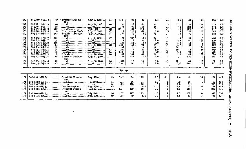
TABLE 2. Partial chemical analyses Of water from wells and springs in the Jenkins-WMtesburg area, Kentucky[Analyses by U.S. Qeol. Survey. Dissolved constituents and hardness given in parts per million. For location of source, see geologic map. Depth of well: r, reported]
Map No.
Kentucky plane- coordinate No.
Depth of well
(ft)Geologic unit Date of
collection
Tem pera ture (°F)
Iron (Fe)
Bicar bonate (HCOa)
Sulfate (S04)
Chloride (Cl)
Fluo- ride (F)
Nitrate (N08)
Hardness as CaCOi
Ca, Mg
Noncar- bonate
Specific conduct
ance (micro- mhos at
25°C)
PH
Wells
2
35 710 111214151617 18 19 2022
2324 262831 323435 3739 41 4243 44 45 46
8-2,839.3-337.9
8-2,839.9-262.28-2,841.7-278.8 8-2,842.0-295.68-2,844.1-344.6 8-2,844.5-287.9S-2, 844.6-296.6S-2, 845. 5-304. 1 S-2, 845.7-281.4S-2, 846.0-268.78-2,846.2-299.9 S-2, 846.3-291.0 8-2,846.6-318.2 S-2, 846. 6-337. 3S-2, 847. 0-281. 8
8-2,847.3-269.7S-2, 847. 5-312. 6 S-2, 847.7-270.2S-2, 849. 4-288. 28-2,850.3-300.5 8-2,850.1-303.3S-2, 851. 1-303.7S-2, 851. 2-291. 8 8-2,851.3-285.5S-2. 851. 7-329. 6 S-2, 852. 2-318. 6 S-2, 852. 2-319.08-2,852.3-329.9 8-2,852.4-297.0 8-2,852.5-297.2 8-2,853.1-312.5
26
93r56r 80r13142010 14
12042 17 11 15
lOOr
4818 17
107r15 190r23
101 97r181 40 94r
225 147r 77 37
Breathitt Forma- tion.
.....do.............. do.. . .....do.. . .. ..__..-. .do..... ___ ... .do- . _ ..do.... __ ...........do..... ... ... do .....do.... ___ . __ .do... ....... . .do......... _ - ..... do... .....
tion. ... -do ...... do....... ... .... ..... do...... ... ......... .do....... ... ........ .do...... ...,. ..do do do do. .....do..... .,. ..... do..... .... . ..... do .._. ......do __ ..... .....do........ ....... .....do . ........ ... ..do- __ - ....
Aug. 11, 1960-
Nov. 9, 1954 Oct. 26, I960 Oct. 25, 1960 Aug. 11, 1960 July 19, I960 June 29, I960 Aug. 2, 1960 ... July 19, I960 Aug. 25, 1960 Oct. 25, 1960 do... Aug. 2, 1960
July 19, 1960
Aug. 25, 1960..Aug. 2, 1960 July 20, 1960 ...Oct. 26, 1960 Aug. 24, 1960- Oct. 4, 1961 do Oct. 25, I960 Oct. 26, 1960 Nov. 9, 1961 Aug. 17, 1960-
Nov. 7, 1961 Aug. 4, 1960 Aug. 9, 1960 Aug. 17, 1960-
55
56
5466 63
64 61
""59""
59
59 64
68
56.555
56 63 60
0.44
.5310.0 5.41.0 .09.28
1.3 .11
1.6.96
6.0 .20
3.4.33
.13
.06
.09
.13
.62
.4213.39 .11
89 4.5 1.2
33 1.5 .62
4.2
84
31098
16220 144233 123442 120 16 34
165
966
15250182 222158225 16221 184 11468 104 145 131
14
2417
.828 24309.6 7.84.4
75.0 1.2 9.2 632.4
2173 131.2
45 27791.8 1.2
1,100 22 1 2
950 51 2487
4.5
4.27.0
3632 25168.0 3.01.07.0 8.0 3.5 4.51.0
3.015 2.0116.0 261186 1.0
19 6.5 2.0
336.0 9.0 3.0
0.2
.2
.1
.1
.1 ,1.1.1 .1.1.1 .1 .2 .2.2
.1
.1
.2
.4
.1
.2
.2
.2
.2
.1
.2
.2
.1
.1
.2
.1
3.2
.1
.4
.664 52605.0 .3.2
18 .7
8.1 2.5.0
2.515 2.1.1
13.4.1.1
11 3.5 .2.5
3.3 .5 1.6
81
9498 101176 9114229 1022146 72 39 11688
102175 2234
231 124166128 107
1,703 150 83
1,724 161 165 160
6
90
80 4054100
56 0 13 440
1285 50
41 0180 0
843 0 0
838 38 23 26
188
515213 379359 269282115 4366
272 217 78 188252
213267 65410413 473439633 254
1,780 356 200
1,800 304 308 400
7.5
7.96.5 6.95.9 6.06.76.1 5.96.66.4 6.7 6.1 6.47.2
6.45.5 6.77.16.87.47.07.1 6.85.4 7.8 6.65.9 6.4 6.7 7.0

474950515355575859
6061626467
68707172
7374757677
787980
8182
838485868890919394959798101103104105
S-2, 853. 1-336. 58-2,853.2-336.88-2,853.4-307.0S-2, 853. 5-298. 48-2,853.5-319.88-2,853.7-308.2S-2, 854. 2-300. 28-2,854.3-289.8S-2, 854. 7-311. 3
8-2,854.9-329.38-2, 855. 6-303. 18-2, 856. 5-276. 28-2,857.5-282.5S-2, 858. 1-296. 8
8-2,858.2-297.78-2,859.2-293.68-2, 859. 3-278. 28-2, 859. 7-293. 3
8-2,859.8-290.9S-2, 859. 9-278. 38-2,860.2-296.18-2,860.2-269.1S-2, 860. 7-288. 7
8-2,861.0-288.78-2,861.34-271.38-2, 861. 35-271. 3
8-2,861.4-279.6S-2, 861. 4-291. 2
8-2,861.4-312.18-2,861.7-296.18-2,861.8-303.38-2,861.8-303.8S-2, 862. 3-300. 28-2,862.4-337.2S-2, 862. 5-328. 7S-2, 862. 7-328. 78-2,863.0-343.48-2,863.0-343.6S-2, 863. 2-264. 4S-2, 863. 7-320. 98-2,864.7-301.58-2,868.6-327.1S-2, 868. 9-343. 88-2,869.9-281.2
3826109r1801613211221
2685r3350
200r
551828r113r
1466
Sir12145
251251
96105
12124612
153123r174017
1201832471611210
38 ?!6
109r1801613
1221
26Sfir3350
55 18 28r 13r
1466
Sir12
145
251251
96105
1?12Afi
12L53 ?,3r17 40 17SO1832 47 6112 10
__ do _ .. _ .... ... .....do.. ............... ..do ..... do......... ......... .do .... .do.. ..... do ........Alluvium ...........
tion. ..... do ........ .... .do ..... do ... ...Lee Formation ....
tion. ... -do ........ do ..... .Lee Formation.. ..
tion. ... ..do ...... . .... .do ........... do ... .....Alluvium... ____ .. Breatbitt Forma
tion. ..... do... ......
tion.
Breathitt Forma tion.
..... do ....... do ... ......... do do .... ... .... ...... do.. . ..... do ............. do.... do.... ... ... . ..... do... ... ....... ...... do... .... . ........... do...... ............. do. ... .. ..... do.. .... .... . do.... ...... do....... ....... Alluvium. ..........
Aug. 18, I960.. June 22, I960..Aug. 18, I960-July 1968 Aug. 17, I960..June 22, I960..Aug. 24, 1960..July 18, 1960 June 23, 1960-
June 22, 1960...Aug. 18, I960...Aug. 25, 1960
, .do Aug. 23, I960...
.... .do
... ..do .... Aug. 25, 1960 .. Aug. 23, 1960
..... do Aug. 25, I960...
Nov. 1954 July 19, 1960...
June 29, I960...June 30, 1960... do
Aug. 23, 1960
June 23, I960...June 29, I960...June 23, I960
Aug. 24,1960-. Aug. 18, I960 Aug. 3, 1960
. do. . Aug. 11, I960- .
. __ do.. .July 20, I960...Aug. 3, I960.. . Aug. 24,1960.. Aug. 9, I960.. .Aug. 11,1960.. June 29. I960
69
62
6462
667367
62 59 69
58 64
63 56
61
64
59 61 6457
........
6059
11.0.56.53.15.17.14
2.7.04.10
.183.2222.61.5
27.32.74.33
.321.21.6.17
1.1
1.15.1.18
.2817.0
.73
.087.6.22.10.17.48
2.5.09
5.2.46
7.316.97
1.1.24
6238230294251415172.0
181183039191
1781298284
227281481660
41293
14487
6222723432630014
14838967
34661906610
316921.2
22120912414
232
1823
.812
137
14231239
315.2
74142.0
3.4136.4
6.621
233413212.012142.627566.8
1215430592.4
1476S3
8.05.56.08.03.0
3.04.02.04.04.0
8.02.57.06.5
5.012104.02.0
3.53.06.0
1.09.0
3.56.02.54.5
218.09.02.52.55.03.04.08.0547.04,0
.0
.2
.2
.2
.1
.2
.1
.2
.1
.2
.1
.1
.2
.2
.2
.2
.2
.2
.1
.1
.1
.2
.1
.1
.1
.1
.2
.3
.1
.1
.2
.3
.8
.0
.1
.1
.2
.1
.1
.2
.2
.2
.1
.053
.2
14.41.6
36.2
.82.8.11.3.6
2.6.2.9.8
.6
.61.76.3.1
2.81.8.4
1.01.1
1.3121.14.1.1.2
14123.51.23.26.0.21.24.8.4
629297721112661725486367
33942827
397
1604468
227
214371792037
113466
11884
6776495874441177113910
282142701766
28913300
124802036183
9020
120
71700
1472900
4120
06
8290150016020302
127440610
755622523
1,230366241111168493
7825254100580
33086204510
4159942082.2150
3068175
232218
1571661571345455041242741452813635325555727136
7.16.78.28.56.46.26.26.94.7
6.66.76.26.66.8
6.86.96.97.0
7.16.36.96.06.6
5.55.86.7
7.76.5
6.76.06.66.27.48.35.66.66.36.75.85.96.37.16.75.9

TABLE 2. Partial chemical analyses of water from wells and springs in the Jenkins-Whitesburg area, Kentucky Continued[Analyses by U.S. Geol. Survey. Dissolved constituents and hardness given in parts per million. For location of source, see geologic map. Depth of well: r, reported]
to
Map No.
Kentucky plane- coordinate No.
Depth of well
(ft)Geologic unit Date of
collection
Tem pera ture (°F)
Iron (Fe)
Bicar bonate (HCOj)
Sulfate (S04)
Chloride (01)
Fluo- ride (F)
Nitrate (N03)
Hardness as CaCOj
Ca,Mg
Noncar- bonate
Specific conduct
ance (micro-
mhos at 25°C)
pH
106107
108109
110111 112113 114115116117118119121122 123124131133134136137138139140141142143144145.146
S-2, 869. 9-311. 9S-2, 870. 0-312. 7
S-2, 870. 2-271. 9S-2, 870. 2-303. 9
S-2, 870. 2-304. 3S-2, 870. 3-329. 0 S-2, 871. 1-343. 7S-2, 873. 4-317.4 S-2, 876. 2-334. 8S-2, 876. 5-327. 9S-2, 876. 9-302. 7S-2, 877. 1-313. 1S-2, 877. 1-334. 6S-2, 877. 6-302. 1S-2, 878. 5-344. 4S-2, 878. 6-318. 9 S-2, 878.9-312.1S-2, 878. 9-320. 6S-2, £8 1.6-342. 3S-2, 885. 8-336. 1
, S-2, 885. 8-336. 7S-2, 887. 1-318. 1S-2, 887. 2-311. 5S-2, 887.6-313.1S-2, 892. 9-322. 9S-2, 894. 1-320. 2S-2, 894. 2-321. 8S-2, 894. 8-313. 8S-2, 895. 0-313. 6S-2, 900. 4-319. 8S-2, 900. 6-313. 7S-2. 900. 7-313. 7
996
1022
4310 62141 63r2819107
112r114r12
163 11160r65r1535119
90r20448692r140r
29
Alluvium ______Breathitt Forma
tion.
tion. ... . .do.... .... do. ... .. do... ... ......... .do.-- ... . .do... .......... ......do. _ . ... _ .do ... ... ..do..... .........do ..do................... .d3 ... - .do..... ... ... . ..... do . - -
do . - -_.... .do ... do ... ... ... ..do... .... ........do ..... .... .....-.do - . .do ... ... ......... ..do.... .... .... do , ..do ... ...... .... .do ..... ... .....do ...... ... ..._ __do
.....do...............
June 22, I960 June 28, I960
July 20, I960- .June 22, I960- -
Aug. 9, 1960- - Aug. 11,1960-.Aug. 2, 1961
Aug. 2, I960.-July 28, I960. .Aug. 9, I960...Aug. 2, I960...July 28, I960 July 26, I960 Aug. 4, I960 July 28, I960 Aug. 3,1961 July 26, I960 __ do ..............do ......July 28, I960 July 21, I960 -.do ..... .Aug. 3, 1961July 27, I960 __ do .........Aug. 10, I960..July 21, 1960 July 27, I960 July 21, I960 July 21. I960...
R9
62
57fiQ786263
6863
""64""
59
63656364
59
56
56
0.86.59
(Uen
141.14.7.30
4.342
.023.0.50
6.82.26.3
1 8.68.19
45.09.03
7.9.39.36.38
2.7.38
2.65.1.13
124178
11
3626 131284 65465
1342506323
2340
27917426824
1088465
2421381782082122701153
123181
6.617
2275 3.623 391437.8
51151
6.421102
7636166808705023103.05945531.47.0
30
1524
1.05.0
1310 5.0
132 8.54.5123.03.01.06.5
32 4.0492.0
359.02.5132.0
441.05.04.03.0102.09.0
.1
.3
.0
.1
.2
.2
.3
.10.1.1.1.1.1.1.1.2.3.1.2.1.1.1.3.1.1.11.0.2.1.1
3.92.5
1.7L4
1.27.9 .3.2
o n
1.2221.21.1
.1
.1 1.6
.818
.11.6
23.0.21.11.02.0.5
3.4.8
17
437278
35
6957 70136 107288541301185241210 404187132574
1,59621310781781001361831821706071
11866
11^
2018 00
27126251002
119
20200
177708621914000640034
491714
3770
157275 22489090Q407139330722122112662474723344849
1,430328338166529226412420430450196144
7.07.4
5.86.5
6.26.2 7.27.4 6.65.95.36.96.67.25.96.8 4.257.77.17.05.76.96.66.47.27.67.17.17.06.87.25.2
CO
< Z'9o 9'z 3 i;z
16989
292
012 2Z
101
9 0
f 9 I I
01
S* 091
St
82
9 'I I 'I
8 'I t'2 9 '2 8'
2' 2'
2*rI'r0
O'l 9 'I
O'l IS
9 'I O'l
0-2
SZ
61 2 '6 82 II
SI
Of Z62
081 Z8001 92
SI' ZI'
Z'l IS' 60' II'
69 99
89 W SS
69
"096I'3nv "1961 ̂tnjt --op - -""0961 Sny --op " "0961 'PO
.... - op --
............. .op. .
- -- - op- .... ........ -pp --
.........
0'W!-9'I*6 '2-S
O'SSS-9'298 '2-S
e oss-rws 'z-s
6i2S-I9»8 2-S
8ZI
Zil 9ZI Sil WI
SZI
, s8uudg r/j5 Z'9 M Z'9 2)si rz » z;z5 9 '9u 8!9^ Z'9* ?:? > * *
= 2'Z 5 Z'9 =i 9 '9r 8'9g 8-9 5 8'9
ZI2 88
2S8 688 682 2H 091 281 862 611
298 892 ZI6
WS
6*2
H SI
0 82 0
Z2 9 0 92 0
0 28
H
201 Of
9tl 8Z 8Z IZ S9
Z9 99
OZ 091 018
2IT
ZOT
f'l 01
I' 6 'I 8 'I
6192
O'l 9'S 6'
8'8' 8'I'Z ZI
0'2
2'
r2'r0'r
i;
8'2' I' I' 2'
I'
O'S O'S
0'2nO'S
O'SII02 O'S
O'S 21
S2 O'l 88 91 SI
9 '9
Z2 01
9 'ItsSI 92 91
9 '8 82 2 '8
O't 98
291 18
98
1621
822 601onz12 89 881 81 Z92
9ZI 811
0618Z
96
f'S 28'
os;0'9 12' 98' 8 '2 98'
81' 82'
Z8'01'
29 89'
89 39
99 99 99
89
Z9
Z9 Z9 89
09
99
op -
"096i 'zi 'any op ...... op - ---op
op op- 0961 '2 'any
1961 '61 ^Inf U«6l 'Z2 ^l"f _ _ ^ggj *PO op -""0961 *Z2 A"JC-"0961 '6 '8ny
op " -op -
UOfl
- -op
..... .....Op ...... ......op - op - .Op ..... ..... .....op
"9lBtlS B300UBIJBIIC) op - ...... .....Op - - op -
61
088
82
801 II
JOOI
291 8 002 22 99
9 J frS-t >86 'E-SS'iS8-9 886'2-S 2'/88-0'886|2-S
9 W8-S '9C6 'Z-S f '8*8-9 '926 '2 -S 0'SS£-9'618Y-S
Z'»2e-l'9l6'2-S
2 'm-0 '016 '2-S 9 'eiS-6 '800 '2-S2 ;z22-2 ;ioe ;g-s9 'Z28-1 '106 '2-S
f'iS8-Z'OOe'2-S
IZI
Oil 691 891 i9I 991 991 WI 291 191
691 991
8*1
ZH

TABLE 3. Comprehensive chemical analyses of water from wells and mines in the JenJcins-Whitesburg area, Kentucky[Analyses by U.S. Geol. Survey. Dissolved constituents and hardness given in parts per million. For location of source, see geologic map. Geologic unit is the Breathitt
Formation (Pbt), except for No. 150, which is in the Price and Maccrady Formations (Mpm)]
Geologic map No.Kentucky
plane-coordinate number
Depth of we 11 (feet)
Date of collection
Temperature (°F)*«5oinC3
55
£ 1
Manganese (Mn)Calcium (Ca)
Magnesium (Mg)Sodium (Na)
g
1
Bicarbonate (HCOa)
Sulfate (SO4) Chloride (Cl) Fluoride (F) Nitrate (NO3)
Dissolved solids (residue
at 180°C)
Hardness as CaCOs
a 0
Noncarbonate
Specific conductance (micromhos at 25°C)
s
tw
13
oto
Io
Wells
21262752QQ
99135150
180 181184
S-2, 846.9-337.4S-2, 848.5-338.8S-2, 849.0-329.5 S-2, 853.5-298.403S-2, 862.3-301.7S-2, 863.7-343.3S-2, 886.4-327.2S-2, 905.5-315.0
S-2, 891.7-337.3 S-2, 898.5-333.9S-2, 906.0-327.3
lllr94r
150rion
56r303r75r76
......
......
May 1962 ...Apr. 19, 1962..Nov. 9. 1961... July 1952.. ....
Jan. 27, 1953...July 26. 1960. .Apr. 18, 1962..
Aug. 1953. .
Jan. 1953..
57 585751
50
635859
121419 101514
8.8
10 3.98.3
0.39.18
52 1.44.53.6.381.5
2.8 .22.03
0.02.302.3.28.07.92
.43
0.00 .00.00
166.4
124 273261
64
64 8259
5.82.4
41 9.29.419
19
Mine
28 3327
31815336 1742648239
6.1
I
70 230160
4.82.92.5 7.01.82.7
2.0
7.3 9.37.3
258270
0 291169154476286
284 620532
1.812
590 11311602.414
181297163
3759412
1765.0
30952.3
5.1 1410
0.6.6.1 .4.2.2.8.2
0 .1.2
2.3.1.2 01.72.51.0.9
2.9 1.32.4
864419879
210426
260
511987710
6426956
11923210
241
316 340260
00
478 00
63
42 00
1,6407QQ
1,220 1,020OQQ
6321,010458
788 1,4701,090
8 >,7 7
7 4
7 97.5
7.2 7 75.3 a
M «
I

GROUND WATER IN JENKINS-WHITE SBURG AREA, KENTUCKY A27
TABLE 4. Significance of dissolved mineral constituents and physical propertiesof natural water
Constituent
Silica (S1CW
Iron (Fe)
Manganese (Mn)
Calcium (Ca) and magnesium (Mg)
Sodium (Na) and potassium (K)
Bicarbonate (HCOs) and carbonate (COs)
Sulfate (SO4)
Chloride (Cl)
Fluoride (F)
Nitrate (NOj)
Source
Siliceous minerals present in all formations.
The common iron-bearing minerals present in most formations.
Manganese-bearing minerals.
Minerals that form limestone and dolomite and occur in some amount in almost all formations. Gypsum also a common source of calcium.
Feldspars and other common minerals; ancient brines, sea water; industrial brines and sewage.
Action of carbon dioxide in water on carbonate minerals.
Gypsum, iron sulfldes, and other rarer minerals common in waters from coal mining operations and many indus trial wastes.
Found in small amounts in all soils and rocks; natural and artificial brines, sea water, sewage.
Various minerals of wide spread occurrence, in minute amounts.
Decayed organic matter, sew age, nitrate fertilizers, ni trates in soil.
Significance
Forms hard scale in pipes, boilers. Inhibits deteri oration of zeolite-type water softeners.
Oxidizes to a reddish-brown sediment. More than about 0.3 ppm stains laundry and utensils reddish brown and is objectionable for food processing and beverages. Larger quantities impart taste and favor the growth of iron bacteria.
Rarer than iron; in general, same objectionable features; brown to black stain.
Cause most of the hardness and scale-forming prop erties of water; soap consuming.
In large amounts give salty taste; objectionable for specialized industrial water uses.
In combination with calcium and magnesium form carbonate hardness which decomposes in boiling water with attendant formation of scale and re lease of corrosive carbon dioxide gas.
Sulfates of calcium and magnesium give bad taste and form hard scale.
In large enough amounts gives salty taste; objec tionable for various specialized industrial uses of water.
In water consumed by children, about 1.5 ppm and more may cause mottling of the enamel of teeth, and about 1.0 ppm seems to reduce decay of teeth.
Values higher than the local average may suggest pollution. There is evidence that more than about 45 ppm NOs may cause methemoglobine- mia ("blue baby") of infants, sometimes fatal; so waters with high nitrate should not be used for baby feeding.
treatment. Water with a hardness of 121 to 180 ppm is considered hard and usually requires softening. Water with more than 180 ppm of hardness is considered very hard and requires treatment for most domestic and industrial purposes. Of the 141 samples analyzed for hardness from the Jenkins-Whitesburg area, 39 were soft, 47 moder ately hard, 25 hard, and 30 very hard. The hardness ranged from 4 to 1,724 ppm.
The quantity reported as dissolved solids represents the residue after evaporation and consists mainly of dissolved mineral matter. Some water of crystallization and organic matter may be included. Water with less than 500 ppm dissolved solids is satisfactory for most uses. Water having more than 1,000 ppm dissolved solids may re quire treatment to produce suitable water for domestic or specialized industrial use. Dissolved solids in 142 samples from the Jenkins-

A28
CO
NT
RIB
UT
ION
S
TO
T
HE
H
YD
RO
LO
GY
O
F T
HE
U
NIT
ED
S
TA
TE
S

GROUND WATER IN JENKINS-WHITESBURG AREA, KENTUCKY A29
Whitesburg area ranged from 18 to 1,058 ppm. The average was 198 ppm of dissolved solids.
Specific conductance is a measure of the ability of water to conduct electricity. It varies with temperature and the degree of ionization of dissolved mineral constituents, and thus is a measure of the concen tration of the dissolved mineral constituents. Specific conductance is reported as micromhos at 25°C and ranges from 30 to 1,800 micromhos in 141 samples from the Jenkins-Whitesburg area.
The hydrogen ion concentration expressed as pH is an indication of the acidity or alkalinity of water. It is often used as a measure of the solvent power of water. Neutral water has a pH of 7.0; water having a pH of less than 7.0 is classed as acid, and water having a pH of greater than 7.0 is classed as alkaline. Water with a pH of less than 4.5 usually contains free mineral acids. Values of pH in samples from the Jenkins-Whitesburg area range from 3.5 to 8.5.
SIGNIFICANCE OF SOURCE FORMATION
BREATHITT FORMATION
Although the chemical quality of water from the Breathitt Forma tion varies considerably from place to place, the water is generally suitable for most domestic and industrial uses. Water from the Breathitt Formation can be classed as calcium magnesium bicarbonate, sodium bicarbonate, or sulfate water (fig. 5).
The most undesirable feature of water from the Breathitt Forma tion is the presence of iron (tables 2 and 3), which commonly stains laundry and utensils reddish brown. This water usually must be treated for the removal of iron before use by some industries. Because of the high concentration of iron in the water, one bottling plant was forced to abandon its well and switch to the city water supply. Iron is dissolved from iron-bearing minerals in the rocks of the area and possibly from iron pipes and well casings.
The following table summarizes dissolved constitutents in parts per million in 125 water samples from the Breathitt Formation.
Maximum. ____ _ _ _______Minimum _ __ ___ _ __ ____Median. ___ ______ __ ______
Iron (Fe)
89.02
1.0
Chloride (Cl)
3751.0
15
Sulfate (S0 4)
1,100.8
33
Calcium magnesium hardness as
CaCO3
1,7244.0
118
In many places in the Jenkins-Whitesburg area, the shallowest water in the Breathitt Formation is acid and has high concentrations of iron and sulfate. This is especially true in areas where coal, black
757-271 65 3

A30 CONTRIBUTIONS TO THE HYDROLOGY OF THE UNITED STATES
shale, and coal mines are relatively close to the surface. The acid content of the water in these areas can be attributed principally to the pyrite and marcasite associated with the coal and adjacent strata. These minerals oxidize to form sulfuric acid and ferrous (iron) sul- fate. Such water may usually be cased off as the well is deepened. Water of better quality generally occurs at greater depth.
Water from the Breathitt Formation contained the greatest and the least concentrations of hardness of any water sampled in the area of this report; hardness ranged from 4 to 1,724 ppm. This wide range in hardness shows little relation to depth or location of wells. Al though the median value of hardness is only 118 ppm, many home owners install water softeners in order to make their water suitable for domestic use.
Most water from the Breathitt Formation contained less than 250 ppm sulfate; however, the water from five drilled wells contained more than 250 ppm sulfate. Most water that is high in sulfate content comes from coal seams or black shale.
Chloride was present in low concentrations in nearly all water from the Breathitt Formation in the Jenkins-Whitesburg area; however, 11 samples contained more than 50 ppm of chloride. With the excep tion of water from well 121, which had 375 ppm, chloride content ranged from 1.0 to 176 ppm. As in the Lee Formation, absence of high-chloride water in the Breathitt Formation in this area is prob ably due to the presence of secondary openings, which permit fresh water to enter and circulate through the aquifer.
The presence of nitrate in concentrations greater than the local aver age may suggest pollution. Water from wells 10, 11, 12, and 49 con tained 64, 52, 50, and 53 ppm nitrate, respectively. These are dug wells that are probably contaminated by surface seepage. Water from these wells should not be used in the preparation of infants' formulas, because evidence shows that more than 45 ppm nitrate may cause a type of methemoglobinemia ("blue baby" disease) in infants, sometimes fatal.
The fluoride content of 125 samples ranged from 0.1 to 1.0 ppm. Seven samples did not contain fluoride.
LEE FORMATION
Four water samples were collected from the Lee Formation in the Jenkins-Whitesburg area. The analyses of these samples indicate that most water from the Lee Formation is generally acceptable for domestic use. All sampled water from the Lee Formation in the area should be treated for the removal of iron. One sample (well 81) also contained objectionable amounts of hardness (118 ppm) and would require softening for some industrial and home uses.

GROUND WATER IN JENKINS-WHITESBURG AREA, KENTUCKY A31
Because the Lee Formation in the Jenkins-Whitesburg area is simi lar to the Lee Formation in other areas of eastern Kentucky, data from these areas can be used to support conclusions drawn in the Jenkins-Whitesburg area. Throughout the Eastern Coal Field, 6 per cent of the inventoried shallow wells in the Lee Formation yield salty water (Price, 1962c). Most deep wells penetrating the Lee Forma tion in the Paintsville-Prestonsburg area contain salty water (Baker, 1955; Price, 1956). Baker reports that water from one well con tained 17,150 ppm chloride. Deep wells penetrating the Lee Forma tion in the Kanawha section of the Jenkins-Whitesburg area would probably contain salty water; however, if fractures caused by the Pine Mountain fault occur at a depth permitting fresh water to enter the formation, deep wells in this section may yield fresh water.
The following table summarizes dissolved constituents in parts per million in four samples from the Lee Formation.
Maximum. ___ ___ _ __ __
Iron (Pe)
22.28.74
Chloride (Cl)
311.04.0
Sulfate (SO4)
12.8
7.9
Calciummagnesiumhardness as
CaCOj
1182743
All water from the Lee Formation in this area is obtained from wells and a spring in the Cumberland Mountain section. The wells range from 28 to 96 feet deep and are in the area of outcrop of the Lee Formation. Chloride content in these wells is much less than that reported from the Lee Formation in other sections of eastern Ken tucky and is well within the standards suggested for drinking water by the U.S. Public Health Service (1962).
The plotting of analyses on figure 5 indicated that water from the Lee Formation is of calcium magnesium bicarbonate and calcium magnesium sulfate types. Water from the spring is probably a mix ture of calcium magnesium bicarbonate and sodium chloride.
None of the analyzed water samples from the Lee Formation con tained significant amounts of nitrate or sulfate.
POLLUTION AND CONTAMINATION POTENTIAL,
Although wide-scale pollution of streams and aquifers is not noted in the Jenkins-Whitesburg area, an increase in industrial develop ment or population growth could greatly increase the pollution potential.
Two potential pollutants are untreated sanitary sewage and indus trial wastes. Although Jenkins has plans for the construction of a
A32 CONTRIBUTIONS TO THE HYDROLOGY OF THE UNITED STATES
sewage-disposal plant, Whitesburg is the only city in the Jenkins- Whitesburg area presently operating such a plant. All other commu nities discharge raw sewage into streams or ponds. As most of the streams receiving sewage are relatively small, the streams do not have available enough water to dilute any increase in raw sewage. Thus, an increase in untreated sewage released into the streams would result in heavy pollution.
Many individual dwellings discharge domestic wastes into nearby streams. In general, the volume of domestic sewage is small, and its effect may not extend far downstream; but the cumulative effect of such practices will probably be the same as discharge from municipal sewers.
The disposal of sewage into streams is likely to produce an increase in the following pollutants: Bacteria, dissolved solids, floating debris, odor, and ABS (alkyl-benzene-sulfonate). ABS, a synthetic organic chemical, which retains its original properties and does not decom pose, is a principal ingredient of modern detergents. High concen trations of ABS may cause foaming and unpleasant odors and tastes.
In the Jenkins-Whitesburg area, nearly all industrial wastes are by-products of the coal-mining industry. The most common pollut ants are acid mine waters and wastes from coal-washing plants. Fortunately, much of the coal in the Jenkins-Whitesburg area con tains relatively little acid-producing material; so, the problem is not as severe as in other parts of Kentucky. However, some mines do discharge water having high acidity and high concentrations of iron and sulfate. Wastes from coal-washing plants add to the sediment load of streams and also may increase the acidity and concentrations of iron and sulfate.
Many of these pollutants may be present in some of the streams in the Jenkins-Whitesburg area. As streams may discharge water into ground-water aquifers during floods, continued pollution of streams could result in the pollution of ground-water supplies. Polluted streams may be improved in a relatively short time, but years are gen erally necessary for nature to improve polluted ground-water aquifers.
SUMMARY AND CONCLUSIONS
In the Jenkins-Whitesburg area small to moderate ground-water supplies, capable of supporting small industries and municipalities, may be developed from wells in bedrock. Moderately large water supplies may be developed from a combination of surface-water im poundment and drilled wells. Some abandoned coal mines are poten tial sources of ground water, which if properly developed could yield moderate to large quantities of water. Smal] to moderate sup

GROUND WATER IN JENKINS-WHITESBURG AREA, KENTUCKY A33
plies may be developed from artesian wells, especially in the Cumber land Mountain section. Enough water for a minimum domestic supply may be obtained from nearly all drilled wells in the Jenkins- Whitesburg area.
The Breathitt Formation, which occurs throughout most of the Jenkins-Whitesburg area, is the most important aquifer. Although yield varies from place to place, moderately large supplies are ob tained from drilled wells which intersect numerous cracks and joints. Some drilled wells located in valleys of major streams yield as much as 330 gpm. The yield of wells tapping the Breathitt Formation is controlled by the character of the aquifer, the type and depth of well, and the topography of the specific well site.
The Lee Formation is potentially an important aquifer. Although few wells obtain water from the Lee in the Jenkins-Whitesburg area, in other parts of Kentucky wells obtaining water from the Lee re portedly yield as much as 140 gpm. All inventoried wells in the Lee Formation furnished enough water for a minimum domestic supply. Deep wells penetrating the Lee in the Cumberland Mountain section may yield moderate quantities of water under artesian pressure from porous sandstones.
Ground water in the Jenkins-Whitesburg area is principally of the calcium magnesium bicarbonate type containing, in places, objection able quantities of iron, sulfate, and hardness. Nearly all water from the Breathitt Formation is fresh and suitable for most domestic and industrial uses, although for specialized uses some treatment may be required. Water from the Breathitt is likely to contain high con centrations of iron and sulfate where the water drains through beds of black shale or coal.
Unlike most water from the Lee Formation in other areas of Ken tucky, all water from the Lee in the Jenkins-Wliitesburg area is fresh. However, nearly all water from the Lee Formation contains objection able quantities of iron.
In this area, water from the alluvium is usually softer and less mineralized than water from bedrock aquifers. Little information is available, however, on chemical quality of water from aquifers other than the Breathitt and Lee Formations and the alluvium. All water is fresh and generally suitable for most domestic and industrial uses.
In the Jenkins-Whitesburg area ground water is recovered from wells, springs, and a few coal mines. Most dug wells supply enough water for small domestic supplies from alluvium or from mantle over lying bedrock. Nearly all drilled wells furnish enough water for a domestic supply and generally produce a dependable, safe source of water. Most perennial springs, when improved and provided with a

A34 CONTRIBUTIONS TO THE HYDROLOGY OF THE UNITED STATES
collection basin or reservoir, produce enough water for a small domestic supply. Some coal mines, if properly sealed, may yield enough water for small industrial or municipal supplies.
Drilled wells offer the most dependable source of water in the Jenkins-Whitesburg areas; however, dug wells may be satisfactory where the water table is relatively close to the surface. Dug wells may be especially useful in the alluvium because they penetrate the entire thickness of the alluvium easily and their large diameter provides large storage capacity and infiltration area. Because of their shallow depth dug wells are specially susceptible to contamination, and care should be used to prevent the entrance of surface drainage.
Some methods of disposal of sanitary sewage and industrial wastes produce pollutants capable of contaminating local streams and ground- water aquifers. Such practices should be closely monitored in order to minimize the effect on existing and future water supplies.
SELECTED REFERENCES
Baker, J. A., 1955, Geology and ground-water resources of the Paintsville area, Kentucky: U.S. Geol. Survey Water-Supply Paper 1257,123 p.
Butts, Charles, 1914, The coal resources and general geology of the Pound quad rangle of Virginia and Kentucky: U.S. Geol. Survey Bull. 541, p. 165-221.
Campbell, M. R., 1893, Geology of the Big Stone Gap coal field of Virginia and Kentucky : U.S. Geol. Survey Bull. Ill, 106 p.
1898, Description of the London quadrangle, Kentucky: U.S. Geol.Survey Geol. Atlas, folio 47.
Collier, C. R., and Krieger, R. A., 1958, Quality of surface waters of Kentucky,1953-55 : Kentucky Dept. Econ. Development, 219 p.
Comley, H. J., 1945, Cyanosis in infants caused by nitrates in well water: Am.Med. Assoc. Jour., v. 129, p. 112-116.
Crandall, A. R., 1887, Report on the Pound Gap region: Kentucky Geol. Surveyprelini. rept. on southeastern Kentucky coal field, p. 1-29.
1905, The coals of the Big Sandy Valley, south of Louisa and between Tug Fork and the headwaters of the North Fork of Kentucky River: Ken tucky Geol. Survey Bull. 4, 141 p.
Crider, A. F-, 1916, Coals of Letcher County: Kentucky Geol. Survey, ser. 4, v. 4, pt. 1, 234 p.
Fenneman, N. M., 1946, Physical divisions of the United States: U.S. Geol. Survey (map).
Hayes, C. W., 1891, The overthrust faults of the southern Appalachians (with a discussion by C. D. Walcott, W. M. Da vis, and Bailey Willis) : Geol. Soc. Ani. Bull. 2, p. 141-154.
Hem, J. D., 1959, Study and interpretation of the chemical characteristics of natural water : U.S. Geol. Survey Water-Supply Paper 1473, 269 p.
Hodge, J. M., 1887, Preliminary report on the geology of parts of Letcher, Harlan, Leslie, Perry, and Breathitt Counties: Kentucky Geol. Survey prelim, rept. on southeastern Kentucky coal field, p. 30-52a.
1908, Summary of report on the region drained by the three forks of the Kentucky River: Kentucky Geol. Survey rept. prog. 1906-7, p. 36-45.

GROUND WATER IN JENKINS-WHITESBURG AREA, KENTUCKY A35
Hodge, J. M., 1910, Report on the coals of the three forks of the Kentucky River : Kentucky Geol. Survey Bull. 11, 280 p.
1912, Report on the Upper Cumberland coal field; the region drained byPoor and Clover Forks in Harlan and Letcher Counties: Kentucky Geol.Survey Bull. 13, 223 p.
Hoeing, J. B., 1913, The coals of the upper Big Sandy Valley and the headwatersof the North Fork of the Kentucky River: Kentucky Geol. Survey, ser. 4,v. 1, p. 79-261.
Hudnall, J. S., 1923, Map of the structural geology of Pike County, Kentucky:Kentucky Geol. Survey.
1925, The Elkhorn coal field: Kentucky Geol. Survey, ser. 6, v. 27, p.131-133.
Hunt, C. B., et al., 1937, Coal deposits of Pike County: U.S. Geol. Survey Bull.876, 92 p.
Kulp, W. K., and Hopkins, H. T., 1960, Public and industrial water supplies ofKentucky: Kentucky Geol. Survey, ser. X, Inf. circ. 4,102 p.
Kilburn, Chabot, Price, W. E., Jr., and Mull, D. S., 1962, Availability of groundwater in Bell, Clay, Jackson, Knox, Laurel, Leslie, McCreary, Owsley, Rock- castle, and Whitley Counties, Kentucky: U.S. Geol. Survey Hydrol. Inv.Atlas HA-38.
McFarlan, A. C., 1950, Geology of Kentucky: Lexington, Ky., Univ. Kentucky,531 p.
McGrain, Preston, 1953, Miscellaneous analyses of Kentucky brines: KentuckyGeol. Survey, ser. 9, rept. inv. 7,16 p.
McGrain, Preston, and Thomas, G. R., 1951, Preliminary report on the naturalbrines of eastern Kentucky: Kentucky Geol. Survey, ser. 9, rept. inv. 3,22 p.
Meinzer, O. E., 1923a, The occurrence of ground water in the United States:U.S. Geol. Survey Water-Supply Paper 489, 321 p.
1923b, Outline of ground-water hydrology: U.S. Geol. Survey Water- Supply Paper 494, 71 p.
Moore, P. N., 1878, Report on a geological reconnaissance of the region adjacent to the Kentucky and Virginia State line, from Cumberland Gap to the Chatterwha or Big Sandy River: Kentucky Geol. Survey rept. prog 4, new ser., p. 217-240.
Price, W. E., Jr., 1956, Geology and ground-water resources of the Prestonsburg quadrangle, Kentucky : U.S. Geol. Survey Water-Supply Paper 1359, 140 p.
Price, W. E., Jr., Kilburn, Chabot, and Mull, D. S., 1962a, Availability of ground water in Breathitt, Floyd, Harlan, Knott, Letcher, Martin, Magoffin, Perry, and Pike Counties, Kentucky: U.S. Geol. Survey Hydrol. Inv. Atlas HA-36.
1962b, Availability of ground water in Boyd, Carter, Elliott, Greenup,Johnson, Lawrence, Lee, Menifee, Morgan, and Wolfe Counties, Kentucky:U.S. Geol. Survey Hydrol. Inv. Atlas HA-37.
Price, W. E., Jr., Mull, D. S., and Kilburn, Chabot, 1962c, Reconnaissance ofground-water resources in the Eastern Coal Field region, Kentucky: U.S.Geol. Survey Water-Supply Paper 1607, 56 p.
Robinson, L. C., and Crider, A. F., 1949, Structural geologic map of LetcherCounty, Kentucky: Kentucky Geol. Survey, ser. 9.
Stone, R. W., 1907, The Elkhorn coal field, Kentucky: U.S. Geol. Survey Bull.316, p. 42-54.
A36 CONTRIBUTIONS TO THE HYDROLOGY OF THE UNITED STATES
United States Public Health Service, 1962, Drinking Water Standards, Revised:P. H. S. Publication No. 956, 61 p.
United States Weather Bureau, 1961, Climatological data Kentucky, Annualsummary 1961: U.S. Weather Bureau, v. 56, no. 13.
Wallace, J. J., et al., 1953, Estimate of known recoverable reserves of coking coalin Letcher County, Kentucky: U.S. Bur. Mines rept inv. 5016, 26 p.
Wilpolt, R. H., and Harden, D. W., 1949, Upper Mississippian rocks of south western Virginia, southern West Virginia, and eastern Kentucky: U.S.Geol. Survey Oil and Gas Inv. (Prelim.) Chart 38.
1959, Geology and oil and gas possibilities of Upper Mississippian rocks ofsouthwestern Virginia, southern West Virginia, and eastern Kentucky: U.S.Geol. Survey Bull. 1072-K, p. 587-656.
II S. GOVERNMENT PRINTING OFFICEll985


![Hydrology of - USGS · 2012-10-29 · Hydrology of Aquifer Systems in the Memphis Area, Tennessee By ]. H. CRINER, P-C. P. SUN, and D. ]. NYMAN CONTRIBUTIONS TO THE HYDROLOGY OF THE](https://img.pdfslide.us/doc/110x75/5e659f858350ee4a7867a865/hydrology-of-usgs-2012-10-29-hydrology-of-aquifer-systems-in-the-memphis-area.jpg)


![[hydrology] groundwater hydrology - david k. todd (2005).pdf](https://img.pdfslide.us/doc/110x75/577c77961a28abe0548cb0b1/hydrology-groundwater-hydrology-david-k-todd-2005pdf.jpg)
![[Hydrology] Groundwater Hydrology - David K. Todd (2005)](https://img.pdfslide.us/doc/110x75/548ce7beb47959e2288b45f9/hydrology-groundwater-hydrology-david-k-todd-2005.jpg)