Embed Size (px)
Citation preview

“Contributions of WMOCommision of Climatologyfor improved Humanitarian
Planning and Response”
Rodney Martínez GüinglaCo-Chair Open Panel of CCl Experts – 4
Climate Information for Adaptation and Risk Management
Geneva, August, 2010

CCl-XV Management Structure
4.3 Task Team on CRM
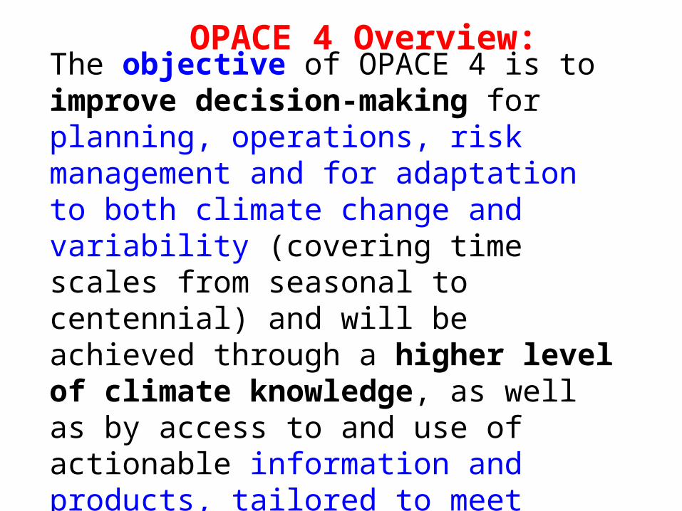
OPACE 4 Overview:
The objective of OPACE 4 is to improve decision-making for planning, operations, risk management and for adaptation to both climate change and variability (covering time scales from seasonal to centennial) and will be achieved through a higher level of climate knowledge, as well as by access to and use of actionable information and products, tailored to meet their needs.

OPACE 4 Overview: Core activities
The activities to be undertaken under OPACE-4 should primarily focus on development of tailored climate information, products and services for user application in adaptation and risk management, and on interface with user groups.
These activities will provide key contributions to the Climate User Interface Programme (CUIP) component of the Global Framework for Climate Services (GFCS). The work of OPACE 4 is multidisciplinary, and requires close collaboration with experts from various socio-economic sectors.

Regional Climate Outlook Fora

6
Existing RCOFs worldwide
(http://www.wmo.int/pages/prog/wcp/wcasp/clips/outlooks/climate_forecasts.html)

“Climate Servicesto improve Early Warning,
Preparedness and Response: some positive
experiences in South America”
Rodney Martínez Gü[email protected]
August, 2010

MISSIONMISSION
“To promote, complement, and start scientific and application research projects, to improve El Niño as well as Climate variability comprehension and early warning at regional scale in order to reduce their social and economical impacts and generate a solid base to promote sustainable development policies to cope with new climate scenarios”

GENERATE GOVERNMENTAL AND LOCAL AUTHORITIES
RESPONSE
GENERATE GOVERNMENTAL AND LOCAL AUTHORITIES
RESPONSE
OPTIMIZEINFORMATION SYSTEMS
OPTIMIZEINFORMATION SYSTEMS
CLIMATE HYSTORICAL ANALYSIS-CLIMATE
FORECAST
Climate VariabilitySubseasonal (MJO)SeasonalInterannual (ENSO)Decadal
Climate VariabilitySubseasonal (MJO)SeasonalInterannual (ENSO)Decadal
CLIMATE CLIMATE EARLY EARLY
WARNINGWARNING
SECTORAL CLIMATE RISK
MAPS
SECTORAL CLIMATE RISK
MAPS
Martínez R., 2004
Communicate to end user is the “last mile” to build up a real people Centered Climate EW system.”.
International Research Centre on El Niño Sasakawa Mention of Merit 2009

From Early Warning to Climate Risk Management…
From Early Warning to Climate Risk Management…
SOCIAL AND ECONOMICAL
IMPACTS REDUCTION
Public PoliciesAnd other
Instruments
GovernmentsGovernmentsResponseResponse
GovernmentsGovernmentsResponseResponse
RISK TRANSFERENCE
EarlyEarlyWarningWarning
EarlyEarlyWarningWarning
SECTORAL PLANNING
LAND USEMANAGEMENT
DESCENTRALIZATION
LOCAL AUTHORITIESIncentives
SUSTAINABLESUSTAINABLEDEVELOPMENTDEVELOPMENTSUSTAINABLESUSTAINABLEDEVELOPMENTDEVELOPMENT
Martínez R., 2004
DISASTERS RISK REDUCTION,
PREPAREDNESS AND RESPONSE,
CONTINGENCY FUNDS
International Research Centre on El Niño Sasakawa Mention of Merit 2009

RCOF:•Opportunity to identify sectoral needs in each country.• Mutual learning process between providers and users• Identify key partners.• Opportunity to review and coordinate further actions.

2002
2003 20042007
2009
The evolution of the Seasonal Forecast in WCSA
2010

Other Regional Climate and Ocean Information Products

Tailoring Climate Products:Some best practices

Climate Information as a regional public good
From Concept to Action

Application of Regional Public Goods principles for Climate information
1) To improve the existing capabilities on NMHSs through a collective action.
2) To share the knowledge of nation-specific benefits and the experience of NMHSs to improve the understanding and prediction of the regional climate but also providing benefits to each country.
3) To contribute on the reduction of asymmetries among countries.
4) To demonstrate through facts that a regional climate service can only be enhanced as a result of the improvement of the national components.
5) To agree on a regional coordination mechanism, in WCSA region this role has bee assumed by CIIFEN.

• First Data integration between NMHS from Bolivia, Chile, Colombia, Ecuador, Peru and Venezuela .
• Online data display.
• 4’153.000 records .
• 171 meteorological stations with data from 1960 to 2009.
• Formal Protocol signed by the 6 NMHS and CIIFEN
WCSA Regional Climate Data Base
http://vac.ciifen-int.org

OPE
RA
TIO
NA
L ST
ATI
STC
AL
DO
WN
SCA
LIN
G

OPE
RA
TIO
NA
L D
YNA
MIC
DO
WN
SCA
LIN
G

Statistical Regional Training Workshop. Maracay-Venezuela, October2007.
Dinamic Modeling Regional Training Workshop. Lima-Peru, November 2007.
Improving Climate Modeling capacities in WCSA
Numerical Modeling Regional Training Workshop. Guayaquil-Ecuador, May 2008
More than 150 experts from the region
have been trained since 2005.

Climate-Agriculture Risk Mapping System in the Andean Countries
ECUADOR
CHILE PERÚ
COLOMBIAVENEZUELA
BOLIVIA
CROPS:Venezuela: Rice, Corn, Sorghum and SesameColombia: Flowers (Roses), Rice.Ecuador: Corn, soybean and rice.Bolivia: Potato, haba y quinoa.Perú: Potato, corn and artichoke.Chile: citrus(orange, lemon and Mandarin orange), avocato.

Bolivia Colombia Ecuador Perú
The Atlas of the dynamics of the Andean territory is an approach for the knowledge integration and cartography in the sub region.
A Result of the interaction and cooperation of the statistics, geological, geographical, hidro-meteorological and seismologic services.
Financed by the European Commission, SG CAN, CAPRADE in the frame of the project PREDECAN.
Coordinated by the OSSO Corporation –Colombia in collaboration with CIIFEN –Ecuador, FUNDEPCO, OXFAM GB, and PREDES–Perú.
ATLAS OF THE DYNAMICS OF ANDEAN TERRITORY

The importance of Building dissemination networks
For climate products

Wide dissemination by
media
End User
Magazines
Newspaper
Radio
Internet
Mobil Phones
Mo
del
ing
Clim
ate
Dat
a B
ase
Statistic
al
Analysis
Risk mapsBulletins
Media articles
Mo
vil m
es
sa
ge
sR
adio
Authorities –Private Sector –Rescue Groups - Community
Climate Information system in the Andean countries
Information translated into
simple language
InvolvingPrivate sector
Technical Information with added
value

Community-based Climate Information Network
Authorities and Community
Local Media Private Sector
Working with the Community ….. for Local Risk Reduction

Alliances Signed with Key
Stakeholders
Mobil Phone Company
Private Sector
Information Flow with the media
Ecuador: Los Ríos mar08Bolivia: El Alto dic08
Venezuela: Maracay sept/08
Chile: V Región oct/08
Including private sector
Perú, aug./08
Improving the Climate information Chain (1)

Installation of radio equipment for 10 locations of intervention area in Ecuador. Divided between the offices of INAMHI and COEs
ESMERALDAS
CHONE
BABAHOYO
MACHALA
MOVISTAR and MESSAGE PLUS, agreed to assign free messages to a group of 1000 users previously identified in areas prone to flooding.
Alliance with Telefónica MOVISTAR
INAMHI inform: intense precipitation over central zone of Manabí for the next 6 hours. WARNING.
Use of Climate Risk Maps Training Workshops. Ministry of Litoral-Ecuador
Applied to: Agriculture, Health, Education, Building, Human settlements and Biodiversity.
Installation of HF Radio Equipment for alternate emergency communications
BOLIVIA
Pachaqamasa radio (El Alto, Bolivia) interview about climate
information use in Aymará native language
NMS is working on translation and bulletins shipping with Forecast in Aymará through Pachaqamasa radio (Bolivia)
Improving the Climate information Chain (2)

Building up an educational Kit of Climate Risk to Local Comunities
• Learning to communicate and assimilate the climate information in a friendly way.
• Communicating on the basis of social and cultural profile of end users.
• Pilot experiences implemented in Ecuador, Bolivia, Peru and Chile.

Chapter I: The Virtual Core of Climatic Applications (NVAC)Chapter II:Implementation of statistical models for climatic predictionChapter III: Implementation of Numerical Models for climatic predictionChapter IV: Implementation of Agro-climatic Risk MapsChapter V:Implementation of local systems of climatic information dissemination Chapter VI: Strengthening building capacity in the in the South America west regionChapter VII: Performance Indicators.Chapter VIII: Learned lessonsChapter IX: future actionsChapter X: Elements of Sustainability
ftp://ciifen-int.org/Technical_Guide_of_a_Regional_Climate_Information_System.pdf
Published December 2009

A proposal to build a prototype where Seasonal Forecasts could be used for
Humanitarian Planning and Response

Seasonal Forecast
Sectoral climate sensitivity analysis + coping capacity
Specific Product (month to season)That allows to activate specific procedures for humanitarian and response planning

Final Remarks

Conclusions• WMO-CCl has established several activities that
could provide effective support to the expected outcomes of this Task Team within the Climate domain during the upcoming years.
• One of the best ways to start an effective implementation could be through a prototype design in a particular region where conditions allow to obtain results and generate benefits quickly and then replicate it in other parts of the world. (recognize and replicate best practices)