Embed Size (px)
Citation preview
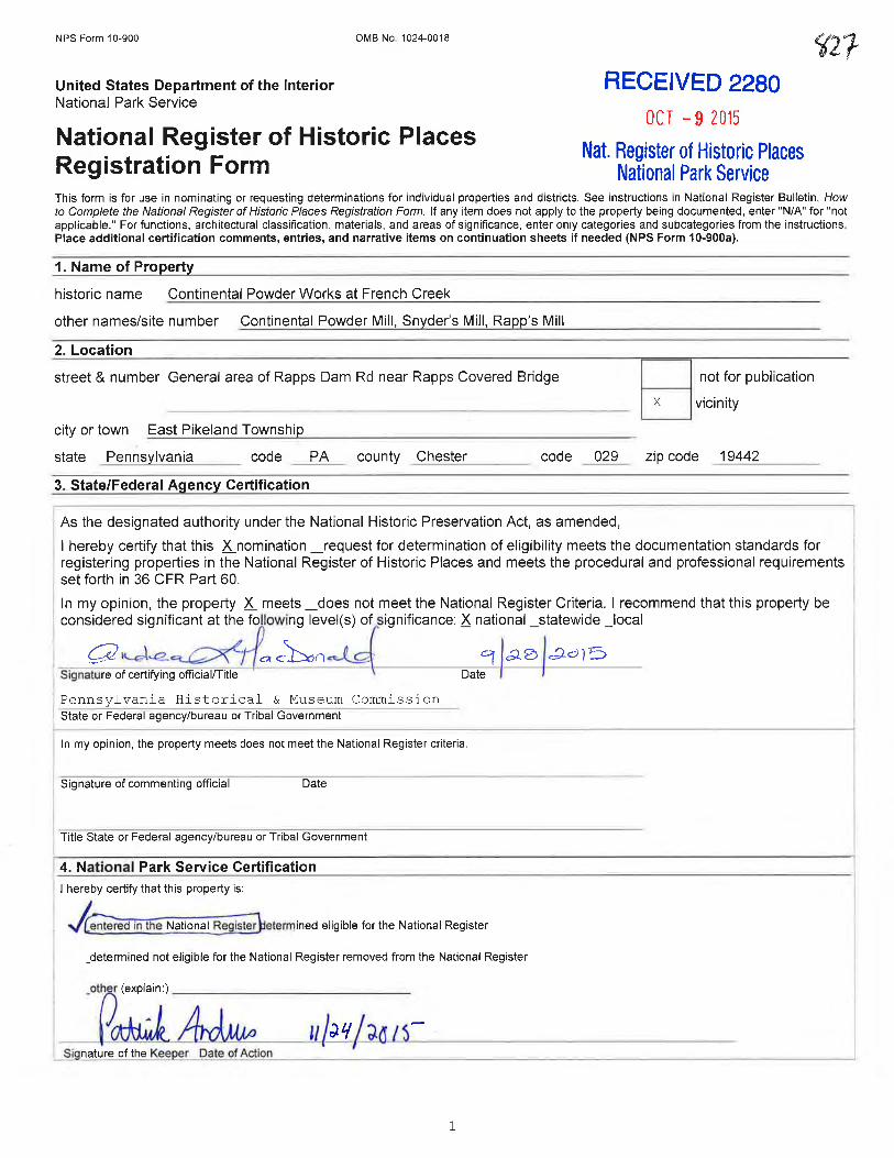
NPS Form 10-900
United States Department of the Interior National Park Service
OMB No. 1024-0018
National Register of Historic Places Registration Form
RECEIVED 2280
OCT -9 2015
Nat. Register of Historic Places National Park Service
This form is for use in nominating or requesting determinations for individual properties and districts. See instructions in National Register Bulletin, How to Complete the National Register of Historic Places Registration Form. If any item does not apply to the property being documented, enter "N/A" for "not applicable." For functions, architectural classification, materials, and areas of significance, enter only categories and subcategories from the instructions. Place additional certification comments, entries, and narrative items on continuation sheets if needed (NPS Form 10-900a).
1. Name of Property
historic name Continental Powder Works at French Creek
other names/site number Continental Powder Mill, Snyder's Mill, Rapp's Mill
2. Location
street & number General area of Rapps Dam Rd near Rapps Covered Bridge
city or town East Pikeland Township
state Penns lvania code PA county Chester code 029
3. State/Federal Agency Certification
Date I I
Pennsylvania Historical & Museum Commission State or Federal agency/bureau or Tribal Government
In my opinion, the property meets does not meet the National Register criteria.
Signature of commenting official Date
Title State or Federal agency/bureau or Tribal Government
4. National Park Service Certification I hereby certify that this property is:
j~ed in the National Reglstef1etermined eligible for the National Register
_determined not eligible for the National Register removed from the National Register
1
D not for publication
L..:.._j vicinity
zip code _1:....:9;....;4--=.4=.2 __ _
United States Department of the Interior National Park Service / National Register of Historic Places Registration Form NPS Form 10-900 OMB No. 1024-0018 Continental Powder Works at French Creek Chester/PA Name of Property County and State
2
5. Classification Ownership of Property
Category of Property
Number of Resources within Property
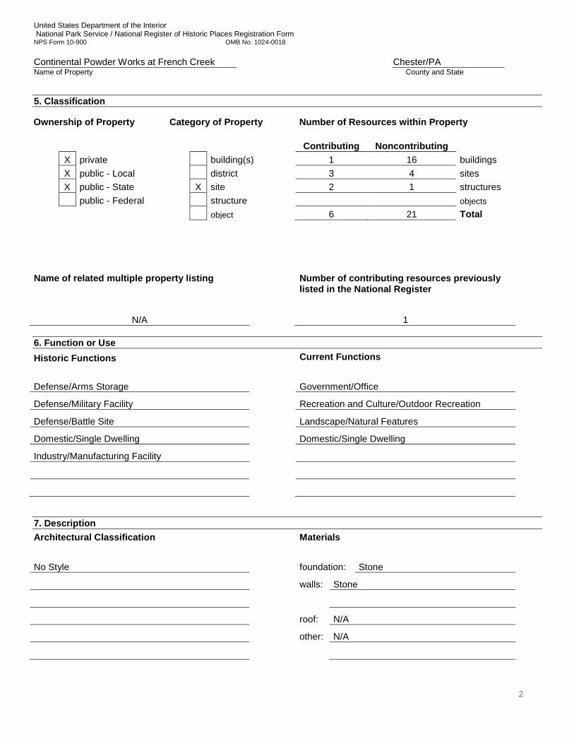
Contributing Noncontributing X private building(s) 1 16 buildings X public - Local district 3 4 sites X public - State X site 2 1 structures public - Federal structure objects object 6 21 Total Name of related multiple property listing
Number of contributing resources previously listed in the National Register
N/A 1 6. Function or Use Historic Functions
Current Functions
Defense/Arms Storage Government/Office Defense/Military Facility Recreation and Culture/Outdoor Recreation
Defense/Battle Site Landscape/Natural Features
Domestic/Single Dwelling Domestic/Single Dwelling
Industry/Manufacturing Facility
7. Description Architectural Classification
Materials
No Style foundation: Stone walls: Stone
roof: N/A other: N/A
United States Department of the Interior National Park Service / National Register of Historic Places Registration Form NPS Form 10-900 OMB No. 1024-0018 Continental Powder Works at French Creek Chester/PA Name of Property County and State
3
Narrative Description Summary Paragraph The site of the Continental Powder Works at French Creek (hereafter, Powder Works, or powder works complex) consists of land generally extending from South Rapps Dam Road, near the Rapps Dam Covered Bridge crossing the creek, in East Pikeland Township, Chester County, Pennsylvania (Figure 1), north of SR113/Kimberton Road. The Continental Powder Works was an industrial complex producing gun powder and armaments for the American Revolution during 1776 and 1777. The historic “Powder Mill Tract” consisted of 119+ acres.1 (See Figure 7) The land slopes downward from the southern and western corners of tract to the floodplain of French Creek. The Powder Works’ identified resources are adjacent to the raceway that follows the base of the slope within the tract. The Powder Works site contains six identified contributing features and is believed to contain additional as-yet unidentified features. The identified features include an extant building (Cava House), the water power system structure and the associated French Creek (an uncounted landscape feature), a historic road bed structure, and stamping mill, graining mill, and drying house sites. Together, these inter-related features form one overall site known as the Powder Works site. The majority of the floodplain along the Creek is now heavily wooded. The central and southern uphill portions of the tract contain 16 non-contributing buildings/building complexes (National Guard Armory complex, East Pikeland Township complex, and nineteenth- and twentieth-century residences), a non-contributing railroad bed structure, and four non-contributing sites that post-date and are not related to the Powder Works. At the eastern edge of the site is the individually-listed Rapp’s Covered Bridge, which post-dates the period of the Powder Works. As it is individually listed, it is not included in the Resource Count. Not all of the land historically included within the Powder Works property is included with this nomination. Acreage that has been compromised by modern residential development (see Figure 5, cf. Figure 2) has been excluded from the boundary. If in the future associated features are identified and retain integrity, the nomination may be amended, if appropriate, to include those features. It is anticipated that most unidentified features will be found within the proposed current boundary. The property currently nominated includes approximately 98 acres. It is not known how much of the land purchased by the Committee of Safety in 1776 under authority of the Continental Congress was actually used for the industrial operations needed to produce guns or powder. Over the course of approximately a year-and a-half, from April 1776 until September 1777, the site consisted of (at least) a dam on French Creek, a hand-dug mill race, a stamping mill, a graining mill, a saltpeter house, four drying houses, a powder magazine, and at least one residence for the manager. A stamping house is the building in which the ingredients of gunpowder (including charcoal, sulfur, and potash) were mixed. The gunpowder was polished and sorted by grain size in the graining mill. Saltpeter (potassium nitrate, a major component of gunpowder) was manufactured in the saltpeter house. Finished gunpowder would be dried in the drying houses. After drying, the finished powder was stored in the magazine or storehouse building prior to shipping. Additionally, the Powder Works site is believed to have housed a gun factory, which included a boring/grinding mill to finish gun barrels, various “smith” shops and support buildings, and a barracks to house local militia. Those features have not yet been identified. Archeological investigations to date have yielded information on the foundations of three buildings related to the powder works: 1) the stamping mill; 2) the graining mill; and 3) one of the drying houses, and one structure, the water system’s raceway (see Figure 2). Eighteenth-century artifacts, some related to military activities or weaponry, have also been recovered. Further archeological investigations within the core area of the site are likely to yield additional information related to the activities and processes associated with the building foundations investigated to date, as well as those that have yet to be explored archeologically. Research suggests that the “Cava” House, a privately-owned dwelling located at the end of Covered Bridge Lane, served as the powder master’s house. It has also been suggested that the later Snyder’s Oil Mill was built on the foundation of one of the drying houses, but at present this is not confirmed. The Township municipal building complex is actively used by township officials and staff, the township police department, and for township maintenance activities. It also includes a communications tower and associates infrastructure. All residences within the boundary are believed to be occupied. An arson fire in 2010 left the main Armory building structurally unsound; however, repairs were made, and the building and grounds continue to be occupied by the Pennsylvania National Guard 728th Combat Sustainment Support Battalion, 213th Regional Support Group. There may
1 As shown on the 1790 Pikeland Map published by Benjamin Chew (see Figure 7). The boundary is incorporated into Figure Maps 4 & 5. Figure Maps 1 & 2 show a modification of this boundary to exclude areas of modern, intensive development.
United States Department of the Interior National Park Service / National Register of Historic Places Registration Form NPS Form 10-900 OMB No. 1024-0018 Continental Powder Works at French Creek Chester/PA Name of Property County and State
4
be buildings, structures, or sites within the nominated boundary that do not contribute to the significance of the Continental Powder Works site, but may be individually eligible for the National Register. While those resources may be independently eligible for other areas of significance, that potential is not addressed here and does not impact this nomination. ________________________________________________________________________________________________________________________ Narrative Description The site of the Continental Powder Works at French Creek was situated in Pikeland Township (today East Pikeland Township), Chester County, Pennsylvania. The location was selected in early 1776 by the Pennsylvania Committee of Safety, with approval of the Second Continental Congress. For approximately eighteen months the complex functioned as Pennsylvania’s only state-owned and operated gun powder works during the American Revolution. In selecting the site along French Creek the intent was to choose a remote, secluded rural area with a sufficient fall of water that was also accessible to Philadelphia. The site was used to make gun powder and arms until September 1777, when Crown Forces destroyed the complex. Today the site retains many of the natural and man-made features associated with its military period of significance of 1776 to 1777. The majority of the area nominated presently consists of a wooded, broad floodplain along a bend in French Creek located at the base of the slope of the valley through which the creek runs. Historic resources visible at the surface stand along and at the base of the slope. The soils along the base of the slope are part of the Penn-Croton-Bucks association. Along the slopes are Penn Series soils, which are a dark red or reddish brown silt loam overlaying a soil of similar appearance, but with more clay. The floodplain consists of Rowland Series soils, which are similar in appearance to the Penn Series, but have a sandy clay loam subsoil (Kunkle 1963:2, 94-98). The remains of a crib dam are visible in the creek at the western end of the parcel (see Figures 2, 8, 14). From this point, a raceway runs eastward to Rapps Dam Road, beginning at a sluice gate along the east side of French Creek (Photograph 1). Midway between the dam and the road are a sluice gate, the ruins of a building, and a tail race that runs to French Creek (Photograph 3). Up slope at roughly this location are the remains of a large barn (Photograph 2). On the flood plain to the north of the raceway are the remnants of stone walls and an associated osage orange hedgerow, and a possible farm lane. The remains of Synder’s Mill stands on the west side of Rapps Dam Road (Photograph 4). A small part of the raceway runs under Rapps Dam Road to the ruins of a mill building, and then back to French Creek. The remainder of the parcel west of Rapps Dam Road holds township administration buildings located just north of an abandoned railroad bed. From this point the ground is maintained as a lawn and slopes down a floodplain partly maintained as a meadow. Evolution of the Powder Works Property In January, 1776, the Pennsylvania Committee of Safety directed that a powder works be built within 50 miles of Philadelphia. Land was acquired along French Creek and a powder works constructed, becoming operational in June, 1776. The works were overseen by Peter DeHaven, a Philadelphia gunsmith, who by early 1777 resided at the works (possibly in the Cava House). A 3 June, 1776, report to the Committee of Safety (Hazard 1853a:765-766) described the powder works complex as consisting of a powder mill (or stamping mill), a graining mill, a saltpeter house, and four drying houses. Both the stamping mill and the graining mill required water power. By early winter in 1777 a gun factory, including a boring and grinding mill for the manufacture of gun barrels, was also in place at French Creek, and the threat of raids by the British forces led to the construction of barracks in January, 1777, to house a company of militia charged with protecting the works (Moore 2011; Salay 1975:437). First references to the Powder Works occur in the winter and early spring of 1776. In February the Pennsylvania Committee of Safety authorized the purchase of land and the construction of the mill. By April the site had been acquired and the order to erect the mill issued. The work was to be directed by Clement Biddle. Two months later, in June, the Continental Powder Works was operational. Peter DeHaven, an area gunsmith, was commissioned to oversee the works. However, Council of Safety records suggest that he continued as superintendent of a gun lock factory in Philadelphia until 20 January, 1777 (Hazard 1853b:272). A detailed account of the complex of buildings at the powder works was reported by John L. Howell to Pennsylvania Committee of Safety. On 3 June, Howell wrote that the mill complex included:
United States Department of the Interior National Park Service / National Register of Historic Places Registration Form NPS Form 10-900 OMB No. 1024-0018 Continental Powder Works at French Creek Chester/PA Name of Property County and State
5
A powder mill [stamping mill] (102 feet by 31 feet 8 inches) with two wheels in the center, each 18 feet in diameter and with a 4-foot head of water and a 9-foot fall [Figure 3]. Each wheel worked three 32.5-foot long shafts. The mill contained six mortar trees 28 feet in length, each with 12 mortars 22 inches long, 12 inches wide, and 17 inches deep. Two 4-inch square and 12-foot long stampers per mortar; A graining mill (37.5 feet by 27.5 feet) built of stone with a water wheel 10.5-foot in diameter to work 72 stampers to prepare sulphur, 12 seives for graining, and one bolting cloth; A salt peter house (21 feet by 27 feet) with 12 kettles, each capable of refining 150wt; Four drying houses, each 21 feet x 27 feet; and A powder Master’s house.
While not specified, the race system was also in place. The mills were scheduled to begin production on 25 June, but spring rains in late May had filled the raceway and damaged the dam, so production did not start until early July 1776. By fall 1776, a detachment of Pennsylvania militia was stationed at the works for protection. The militia formation varied during the fall and winter, and a barracks was under construction by early January 1777. In mid-December 1776 the Pennsylvania Committee of Safety authorized Peter Dehaven to construct a gun factory at the French Creek site. This order effectively relocated the gun factory in Philadelphia to the French Creek site, an action that was taken due to the threat of Crown Forces activities in New Jersey, and a threat that was only removed by the military actions at Trenton (26 December 1776) and Princeton (3 January 1777). As DeHaven reported to the Council of Safety on 3 January 1777 (the same day as the battle of Princeton):
We have got nineteen men at work in the gun way, and I am in hopes we shall be able in a short time to repair a great many arms & make some new ones. Our Smith Shops & other Buildings are in pretty good order by the industry of Col. Deweese & Capt [William] Bodley. The barracks will be finished in a short time if Col Deweese can get boards, as they are very scarce here, and they come [at a] very high [price] to haul them from Philadelphia (Pennypacker 1872:94).
By early 1777 the Powder Works was a busy, bustling place and had become the center of major powder and arms production in Pennsylvania. The complex included a stamping mill, a graining mill, a saltpeter house, four drying houses, a gun factory, smith shops (unspecified number), other support buildings, and a militia barracks of some sort. The works were carried on here with success until 10 March 1777, when an explosion destroyed the stamping mill. During a series of official hearings held because sabotage was suspected, additional information about the buildings, layout, and activities at the site were provided. The depositions confirmed the presence of stamping mill, drying houses, the gun factory, and the graining mill, and also included mention of a guard house, the meadow, and “the dwelling house about 300 yards” from the stamping mill (Pennypacker 1872:95-98). The official investigation of the destruction of the stamping mill concluded that it was an unfortunate accident (Salay 1975:437-438). The stamping mill does not seem to have been rebuilt or put into use, but the gun factory continued production during the spring, summer, and early fall of 1777. On 25 August, a Crown Forces invasion army, under Sir William Howe, landed at the Head of Elk in Maryland (near present-day Elkton, MD). Signaling the start of the fall Philadelphia campaign, Washington’s army, composed of Continental and militia forces, moved to block and engage the Crown Forces as they maneuvered towards the colonial capital. A series of military actions – Cooch’s Bridge (3 September), Brandywine (11 September), the aborted Battle of the Clouds (16 September), the night assault at Paoli (20-21 September) – slowly led the two armies towards the Schuylkill River. Weapons from French Creek were ordered to be sent to Washington’s army on 29 August. By 10 September the threat of destruction of military materials at the site compelled DeHaven to request additional guards for the powder works and for wagons to begin moving powder and guns out of harms way. The destruction of Valley Forge on Valley Creek, a short distance east of the powder works complex, occurred on 18 September. On the night of 20-21 September a British light infantry surprised and overwhelmed a
United States Department of the Interior National Park Service / National Register of Historic Places Registration Form NPS Form 10-900 OMB No. 1024-0018 Continental Powder Works at French Creek Chester/PA Name of Property County and State
6
detachment of Washington’s army at Paoli, and by the evening of 21 September the left flank of the Crown Forces army occupied the area around Charlestown, a short distance east of French Creek. While the above written accounts provide some accurate idea as to the types of buildings present at French Creek, there are currently only two accounts that describe in some detail the military action that occurred on 22 September 1777 when the powder works complex at French Creek was destroyed. Captain Johann Ewald of the Hessian Field Jäger Corps commanded a detachment of approximately 140 men and officers, including mounted and dismounted jägers and grenadiers. On the morning of 22 September, Ewald’s patrol was ordered to move into Pikeland Township, which “lay to the rear of the army, where an enemy party was believed to be stationed” (Ewald 1979:90). A detachment of British Light Infantry from the 2nd battalion may also have been in the patrol (British Light Infantry 1777). Ewald left the Crown Forces encampment near Charlestown at 6am. Two hours later he recorded that:
About eight o’clock I arrived before the village. An enemy party had placed itself behind the houses and fences and fired several shots, to which no attention was paid, whereupon I ordered a quick march to get straight at the enemy. But just as I drew up to within one hundred and fifty paces of the village, the enemy fled into the woods so hastily that not a single man was caught.
The American forces that opposed Ewald were likely Continental troops from Colonel Walter Stewart’s Pennsylvania State Regiment, or PSR (later the 13th Pennsylvania Regiment). Between January and June, the garrison at the powder works was provided by an independent Chester County company commanded by Captain John Pugh. According to the pension application of one of its enlisted men, the company was generally known as the “Powder Works Company” (United States Revolutionary War Pension and Bounty Land Warrant Applications, 1800-1900). After The PSR had been authorized on 6 June 1777, Stewart had been ordered to replace the “Powder Works Company” with Company B of the PSR. Under the command of Captain John Nice, the company was composed of men that were prisoners on parole, likely men captured at the fall of Fort Washington in 1776 (Graham 2011:5; Trussell 1979:169-172). Having brushed aside the American opposition, Ewald pushed on to the powder works complex. He described the complex in the following terms:
I passed the village, which consisted of perhaps forty to fifty buildings but had been completely deserted by the inhabitants. I deployed on the other side behind the hedges or walls and searched through the village, where I found a blown-up powder magazine and a rifle factory, in which several thousand pieces of fabricated and unfinished rifles and sabers of all kinds were stored (Ewald 1979:90)
Continuing to reconnoiter around powder works complex, Ewald “sent Lieutenant Heinrichs with twenty foot jägers into the woods to search it thoroughly for a short distance” but Heinrichs returned to the main detachment without seeing anything or anyone, or further engaging the Americans (Ewald 1979:90). Having secured the area, Ewald’s detachment turned to the razing of the complex. While he offers no specific details as to how he accomplished this, Ewalds states that he “ordered everything smashed to pieces, set fire to the factory, and marched back” (Ewald 1979:91). A second, shorter account of the action at French Creek is contained in a British Light Infantry memorandum book apparently captured by the American forces and now in the George Washington Papers at the Library of Congress. That account states:
the 22nd of September the 2nd Light Infantry on a reconnoitering party found a powder mill, a magazine, and some armorer’s shops and storehouses, which they burnt, and destroyed all that came to hand, along with stores of provisions and forage. (British Light Infantry 1777).
Following the war, the land associated with the powder works was farmed, while the mill race was adapted to serve first a powder mill, and later mills oriented toward processing seeds, grain and lumber. During the first half of the nineteenth century, the Snyder family, likely either Henry’s or Thomas’s family, constructed a house and barn on the west side of Rapps Dam Road, south and east of the raceway. From 1855 to 1858, Dr. Oberholtzer operated a powder mill along a
United States Department of the Interior National Park Service / National Register of Historic Places Registration Form NPS Form 10-900 OMB No. 1024-0018 Continental Powder Works at French Creek Chester/PA Name of Property County and State
7
tributary to French Creek at the southwest end of the Powder Mill Tract. An explosion in 1858 destroyed Oberholtzer’s mill. At some time during the nineteenth century, likely the latter half, two houses were built along the west side of Rapps Dam Road. In 1871, the Pickering Valley Railroad was built through a portion of the tract that held the powder works complex (Bartman and Kindig 1990; Clegg n.d.; Moore 2011; Rapp 1938). In the 1930s, the Borough of Phoenixville purchased the portion of the Powder Mill Tract that had been held by the Snyder family with the intent of taking water from French Creek for municipal use. Finding that the water rights were owned by the Phoenixville Iron Works, the parcel was made a park in 1938. The same year, a grist mill on the east side of Rapps Dam Road, built in 1860 by Benjamin Hartman, was destroyed by fire. The last remaining Powder Works drying house was apparently demolished approximately 12-15 years prior, c.1925. Circa 1964, the Commonwealth of Pennsylvania acquired the tract of land holding the Snyder house and barn, and established the Phoenixville National Guard Armory. During the same period, the township constructed a municipal building on the east side of Rapps Dam Road. In the first decade of the twenty-first century, the building was remodeled and expanded, and maintenance buildings were constructed a short distance to the southeast. During the 1980s, the portion of the Powder Mill Tract south of the railroad experienced intensive residential development. Archaeological Investigations Six previous archeological investigations have occurred on the property (refer to Figure 8). Each survey had very specific goals focused on small portions of the project area. During the architectural stabilization of Snyder’s Mill in 1990 artifacts recovered consisted primarily of architectural elements and parts of the mill’s Hurst frame (Bartmann and Kindig 1990). Descriptions of areas excavated indicated that soils were removed from the southeast corner, “some areas” of the interior, the basement entrance, and “mounds and depressions located west of the mill and in the gear pit” (Bartmann and Kindig 1990:1-5 of addendum). No indication was given of excavation methods, so it is not known if accepted archeological practice was employed. The list of artifacts included few datable items, and insufficient details to enable dating of those that were. The report provided the greatest detail on structural elements of the mill, which enabled a broad interpretation of mill operations over time. Evidence of mill operations covered the nineteenth century and extended into the early twentieth century, a period spanning ownership of the building by Thomas and Henry Snyder and George W. Rapp. In 1997 the cultural resources firm MAAR Associates documented surface features, and conducted a pedestrian survey of an area along the tree line southeast of Rapps Dam Road (Thomas and Zebooker 1997). MAAR’s archeologists also conducted limited shovel testing adjacent to the area subject to the pedestrian survey. Surface reconnaissance for visible features resulted in the documentation of the mill dam, elements of the raceway, and the remains of five buildings. The buildings documented were the remains of the Snyder Barn, identified by Ellis as the powder master’s house site, the presumed remains of the Rudy powder mill, the Snyder mills adjacent to both sides of Rapps Dam Road, and a 20-foot section of wall in the presumed vicinity of the militia barracks and worker’s housing site (Ellis 1946; Thomas and Zebooker 1997:17-18). Surface collection from the area resulted in the recovery of prehistoric and historic-period artifacts. Lithic (stone) materials (n=12) were recovered at several locations, suggesting the presence of prehistoric sites of unknown period. Historic-period artifacts likewise were found, with the majority dating to the nineteenth century or later. However, a concentration (n=9) of late eighteenth century artifacts was found at the northwest end. MAAR characterized the prehistoric site as “transient,” and surmised that the presence of historic-period artifacts might have resulted from agricultural manuring. They did not believe that the artifacts were associated with militia or workers housing (Thomas and Zebooker 1997:18-19, Appendix B). In 1999 John Milner Associates, Inc. (JMA) conducted archeological testing within a 60 by 60-foot area before installation of a cellular telecommunications tower to the southeast of the township maintenance building (Benedict and Catts 2000). Shovel testing was conducted around the perimeter of the project area, and a trench was excavated within the northern corner. As indicated by Public Works Director Mr. Rich Lucas, a layer of fill was encountered in the northern part of the project area, it being a gravel-covered parking and storage location. The remainder of the testing occurred in an adjacent wooded area, where a shallow A-horizon was encountered. Within the trench a Bt-horizon was present under the fill. No artifacts were recovered or archeological features noted. Mr. Lucas also reported that the remnants of a stone wall were located in the woods roughly 200 meters east-southeast of the project area. The authors did not report if the wall was investigated (Benedict and Catts 2000:3-5).
United States Department of the Interior National Park Service / National Register of Historic Places Registration Form NPS Form 10-900 OMB No. 1024-0018 Continental Powder Works at French Creek Chester/PA Name of Property County and State
8
Cultural resource investigations were completed by AMEC prior to construction work at the Phoenixville Armory in 2005 (Andrews and Richmond 2005). AMEC completed the reconnaissance survey of the Phoenixville Armory property, including a portion of land associated with milling operations. The archeological investigations resulted in the identification of a historic-period archeological site (Bureau for Historic Preservation Site #36CH842) along the northwest edge of the Phoenixville Armory property (see Figure 2). An intact ground surface containing nineteenth- to early twentieth-century artifacts was found beneath redeposited topsoil (Andrews and Richmond 2005:22). Just off the edge of the open area stood the remains of a building, this being the same location reported by MAAR as the powder master’s house and barn and later the Snyder residence (Andrews and Richmond 2005:45). Datable ceramics recovered during the survey consisted almost exclusively of pearlware and whiteware, strongly supporting a post-Continental Powder Works occupation. The one fragment of creamware recovered was the only datable ceramic that could have derived from occupation during operation of the Continental Powder Works. Working for East Pikeland Township, JMA archeologists completed limited archeological investigations in 2009 and 2010 resulting in the identification of a buried section of the raceway (see Photographs 5 and 6) and the recovery of military-related artifacts in the field below the Township building (Mancl et al. 2011). Remains visible at the surface were mapped and identified to the extent possible. A magnetic gradiometry survey revealed the location and course of the buried section of raceway, which was confirmed by mechanical trenching. Military-related artifacts recovered during the metal-detecting survey included a brass ramrod pipe, a fragment of a brass musket butt plate, and a lead musket ball (Mancl et al. 2011:35) (Photograph 9). Mapping of remains visible at the surface resulted in the documentation of the water-power infrastructure and three mill building locations. Remains toward the western end of the raceway system, identified as a wheel pit and foundation, were situated and had dimensions that suggested that they could represent the stamping mill. However, the remains could also have been related to Rudy’s Mill, an early nineteenth-century powder mill (see Figure 2). Excavations within the foundation remains resulted in the recovery of cut nails and revealed an area of dense stone rubble. No evidence was found to positively indicate that it was the location a stamping mill (Mancl et al. 2011:35). In 2012, an archaeological survey of a large area of the possible powder works complex was completed by JMA (see Figures 9 through 13). Funded by a grant from the American Battlefield Protection Program (ABPP) the archeological investigations of the complex used a range of field methods including ground-penetrating radar (GPR), soil augering, metal detection, hand-excavation, and mechanical trenching. While some methods produced better results than others, overall the field techniques were all complementary of each other, with results contributing to site interpretations (Mancl et al. 2012). Metal detection was the least effective at the site, recovering no metal artifacts clearly associated with the gun factory, powder works, militia camp, or the engagement on 22 September 1777. The artifacts recovered dated to the post-Revolutionary War period. The areas targeted for hand excavations, located principally to the northwest of Rapps Dam Road and within the floodplain of French Creek, did not contain archeological evidence of occupation during the time the Powder Works operated. Auger testing provided useful information on the construction, formation, and maintenance of the raceway from the dam on French Creek to Rapps Dam Road. Augering also provided information regarding the landscape features to the north and west of the field below the township building, but like the shovel testing did not provide conclusive data on activities during the period of occupation by the Powder Works. By far the most successful technique applied for archeological investigations here was the GPR survey (Figures 11 through 13). The GPR survey, followed by mechanical trenching and hand-excavations, resulted in identifying the remains of two buildings, designated Feature/Structure 1 and Feature/Structure 2. The existence of a possible building identified as Anomaly 20 was recorded, but not archeologically verified. The extent of the raceway was also revealed in GPR survey, which showed the race running along a line about five feet upslope from the floodplain. From this information, it is hypothesized that any downslope Powder Works buildings were highly likely to represent water-powered elements, and that elements not requiring water power would be upslope from the race, since higher ground would be less subject to flooding, and therefore, would contribute to keeping the powder and any dwellings dry. Feature 1 and Feature 2 were targeted for mechanical and hand excavation since both were situated downhill from the race. In addition, GPR data indicated the potential for a wheel pit within Feature 1 and that the race ran through or along the southern end of Feature
United States Department of the Interior National Park Service / National Register of Historic Places Registration Form NPS Form 10-900 OMB No. 1024-0018 Continental Powder Works at French Creek Chester/PA Name of Property County and State
9
2. Finally, GPR work west of Rapps Dam Road identified an anomaly (Feature/Anomaly 4), the possible remnants of one of the four drying houses. Feature 1 (Graining Mill). The overall size and scale of the foundation represented by Feature 1, as well as its location and associated archeological deposits, suggests that the remains are that of the Powder Works graining mill (see Figure 2 and Photograph 9 and 9). John Howell’s June 1776 report to the Pennsylvania Committee of Safety noted the graining mill measured 37.5 feet by 27.5 feet. As delineated from GPR data, Feature 1 measured 37 feet by 28 feet. Information gathered during excavations indicate that the building was robust, having a stone wall thickness of 1.5 feet. Also, the building sat down-hill from the race, and GPR and excavation data suggest the presence of a wheel pit along the northern end. Confirmation of the possible wheel pit could be a focus of future archeological investigations. Furthermore, the soils above the historic floor of Feature 1 (Graining Mill) and the artifacts, specifically the hand-wrought nails (Photograph 10) it contained were altered by high heat, which coincides with Captain Johann Ewald’s report that he ordered his troops to set fire to the buildings in the powder works complex. The presence of hand-wrought nails supports the supposition that the building remains predate the nineteenth century, and the lack of artifacts from a later period indicates that Feature 1 was not reused or rebuilt. Archeological evidence of eighteenth through twentieth century landuse was found in the same area as the buried raceway to the north and west of Feature 1. Artifacts dating to the eighteenth century were collected by MAAR from along the northwestern tree line and in 2009 throughout the area (Thomas and Zeebooker 1997; Mancl et al. 2011). The concentration was sparse, and roughly half of the wrought nails recovered within the segment disturbed by installation of the sewer line running to the township building. Eighteenth-century military artifacts are sparse (ramrod thimble, musket ball, butt plate fragment), but tantalizing, suggesting that Revolutionary War activity took place here. While the evidence indicates human activity in the area in the eighteenth century, the sparseness of artifacts argues against it having once been a living area. Moreover, the paucity of artifacts from earlier and current investigations supports the idea that Feature 1 was related to the powder works. The reason for this is that items that could cause a spark or required the use of fire, such as most metallic objects and smoking pipes, the latter routinely found archeologically at workplaces, could cause an explosion. Feature 2 (Stamping Mill). The overall size and scale of the foundation represented by Feature 2, as well as its location and associated archeological deposits, suggests that the remains are that of the western half of the Powder Works stamping mill (see Figure 2 and Photograph 6 and 7). Howell’s June 1776 report to Committee of Safety indicated that the stamping mill measured 102 feet by 31 feet 8 inches. As delineated from GPR data, Feature 2 measured 45 feet by 31 feet. Excavations resulted in determining a length of 50.5 feet from the center of the dual raceway to the northern end of the western wall. Taken together, Feature 2 measured nearly half the dimension given for the stamping mill. Archeological information gathered during excavations indicate that the building was robust, having a stone wall thickness of 2.0 feet. A dual raceway, one that would enable control of water to two wheels as indicated for the stamping mill, was documented entering the west end of the building. Also supporting documentary evidence was calculation of a fall of four feet to the wheels, taken by determining the elevation of French Creek at the dam, and the elevation of the floodplain at Feature 2. The June 1776 Howell report included a sketch of one-half of the stamping mill (Figure 3), and this sketch helped in the verification of Feature 2 as the stamping mill. The center of the interior wall noted during excavations and in the GPR data stands 32.5 feet from the southern end of the foundation wall, which was the length of the shaft that ran the stampers. This suggests that the interior wall held a support for the northern end of the shaft. As with Feature 1, the presence of hand-wrought nails and spikes in association with the building remains supports the supposition that it predates the nineteenth century, and the paucity of artifacts supports the idea that it was related to the powder works. Further, the corroded condition of the nails, in comparison to the annealed and burnt condition of the nails found in Feature 1 (Graining Mill) suggests that the two buildings met their demise in different ways. While Feature 1 was clearly burned, Feature 2 was not, which may be archeological evidence of the March 1777 explosion. Feature/Anomaly 4, Survey Area 2 (Drying House Foundation). West of Rapps Dam Road the results of the GPR survey indicated the possible presence of a foundation wall at the location of the drying house once located across from Snyder’s Mill (see Figure 2). Anomaly 4 in Survey Area 2 may represent a portion of the east wall, southeast corner, and
United States Department of the Interior National Park Service / National Register of Historic Places Registration Form NPS Form 10-900 OMB No. 1024-0018 Continental Powder Works at French Creek Chester/PA Name of Property County and State
10
south wall of the building, which occupied this location until the early twentieth century (Figure 15). The eastern wall measures at least 10 feet (north to south) while the southern wall is approximately 15 feet in length. Both possible wall segments were damaged by later road widening and disturbance. The GPR data suggest that a stone foundation in somewhat demolished condition is located here, confirming the photographic evidence of a stone building (see Figure 15). The Howell report indicates that four drying houses (each 21 by 27 feet) were present at the powder works complex by June of 1776. Due to time and budget constraints Anomaly 4 was not further investigated during this survey. Known or Anticipated Features Associated with the Powder Works Historically, the powder works complex consisted of a series of buildings, structures, and landscape features that contributed to the production of gun powder and armaments. In addition, the site held infrastructure for the protection of operations by Pennsylvania Militia, and was the location of military action during the Revolutionary War. Known or anticipated elements that defined the character of the site are shown in the following table: Defining Feature Location (Status) Stamping Mill In the field northeast of the Township Building (archeological) Graining Mill In the field northeast of the Township Building (archeological) Saltpeter house Not known
Drying Houses (4x) One building was located at the intersection of Rapps Dam Road and the unimproved road to the dam (historical documentation and archeological)
Guard House Not known Gun Factory and associated outbuildings (aka armorers’ shops and storehouses) Not known
Water Power System (including dam, head race, tail race, wheel pits and sluice gates)
Remains of a dam on French Creek and the existing raceway extending to Rapps Dam Road (topographical); buried raceway in the field northeast of the Township Building (archeological)
“Cava” House End of Covered Bridge Lane (standing; archeological potential) French Creek Northwestern and northeastern edges of the site (topographical) Road across French Creek Earlier road known as Lightfoot Road (historical documentation) Village/Barracks Not known Magazine or Storehouse Near the intersection of Rapps Dam Road and Covered Bridge Lane (historical documentation) Elements of the Powder Works site visible at the ground surface are French Creek, a portion of the raceway, and the remains of a crib dam (refer to Figures 2 and 8). A sluice gate located near the site of the dam is in place, but it does not date from the period of occupation by the Powder Works (see Photographs 1 and 3). Above-ground, it is believed that the Cava House may have been the residence of someone associated with the Powder Works’ operation, possibly the facility’s manager. Archeological investigations to date have yielded information on three buildings related to the Powder Works: 1) the stamping mill; 2) the graining mill; and 3) one of the drying houses. Additional information has been discovered regarding the raceway/water power system. Eighteenth-century artifacts, some related to military activities or weaponry, have also been recovered. The remaining elements of the complex have not been located to date; however, the results of the GPR survey and the survival of the elements located archeologically suggests a high potential for the survival of the remains of other buildings or structures below ground within the Powder Mill Tract boundary. There is no evidence indicating that local tradesmen or citizens contributed to the construction or operations of the powder works, or that those involved with the works lived outside the boundary of the tract. Therefore, all resources associated with the Powder Works are considered to be within the bounds of the Powder Mill Tract. Contributing Features Identified: (The locations of resources mentioned herein are indicated on Figure 2; see also the table at the end of this section titled “Contributing Resources”) The Stamping Mill (site) - The June 1776 Howell report to the Pennsylvania Committee of Safety detailing the conditions of the Powder Works states that the stamping mill, or powder mill, consisted of a building 102 feet long by 31 feet 8 inches wide, with two wheels in the center, each 18 feet in diameter and with a 4-foot head of water and a 9-foot fall. Each of the wheels worked three 32.5-foot long shafts (Salay 1975:436). The mill contained six mortar trees 28 feet in length, each
United States Department of the Interior National Park Service / National Register of Historic Places Registration Form NPS Form 10-900 OMB No. 1024-0018 Continental Powder Works at French Creek Chester/PA Name of Property County and State
11
with 12 mortars 22 inches long, 12 inches wide, and 17 inches deep. There were two 4-inch square and 12-foot long stampers per mortar. An explosion destroyed the building on 10 March 1777 and it was not rebuilt. When the Hessian detachment arrived in September 1777 they found the remains of the stamping mill. The results of the GPR survey and the subsequent archeological investigations to “ground truth” anomalies led to the conclusion that foundation walls documented as Structure 2 are the archeological remains of the Stamping Mill (see Figures 2 and 3; Photograph 7). The dimensions of the remains, its internal configuration, the limited range and condition of the recovered artifacts, and its placement along the raceway led to this conclusion. It appears that only the western half of the building was uncovered. The eastern half may be extant beneath the modern earth pile created by the township’s maintenance operations. The Graining Mill (site) - The 1776 Howell report described the graining mill as a stone building measuring 37.5 feet by 27.5 feet, with a 10.5-foot diameter waterwheel working 72 stampers to prepare sulphur, twelve graining sieves, and one bolting cloth (Salay 1975:436). The graining mill was not damaged in the March 1777 explosion, and was among the buildings destroyed by the Crown Forces in September 1777. The results of the GPR survey and the supporting archeological investigations lead to the conclusion that foundation walls documented as Feature 1 are the archeological remains of the graining mill (see Figure 2 and Photograph 8). The archeological dimensions of the building remains (approximately 37 feet by 28 feet) are nearly identical to the historical dimensions provided in 1776. Further, the archeological investigations clearly indicate the presence of a wheel pit within the building. The limited range and condition of recovered artifacts – particularly the annealed nails and melted glass – suggests that this building was destroyed by fire. A Drying House (site) - The Howell report notes that there were four drying houses, each measuring 21 x 27 feet, present at the complex by June 1776 (Salay 1975:436). Like the other buildings at the complex, these were likely destroyed or damaged by Ewald’s detachment in September 1777. An early twentieth-century post card shows what is reputed to be one of the Powder Works drying houses (Figure 15). The building was located west of the intersection of Rapps Dam Road and the unimproved road that extends along the west side of the mill race. As related by Joseph Rapp in a newspaper article in 1938, “the dry house for the powder works stood at the end of the lane, and the road going to the farm buildings, and was torn down by John White after he bought the property some 12 or 15 years ago [1923-1926]” (Rapp 1938). Eight years later, the grandson of Joseph Rapp added further location information regarding the drying house. In the written statement of Brower Ellis he mentions the powder drying house as “in the corner formed by the intersection of the public road and the drive to the present picnic area. This building was located in the corner on the same side of the private drive as the mill house.” He recalled that the building had been in use “until comparatively recent times” (Ellis 1946:1-2). The GPR testing in the location of the former drying house identified what are likely the remains of this building, although they appear to be in poor condition (Figure 13). While this may be the remains of one of the drying houses, it is also possible that this building dates to a post-Powder Works period. Later milling operations continued on the tract well into the twentieth century. Powder Magazine (site) – Historical documentation indicated that the powder magazine, where finished gun powder was stored before shipping, was located near the intersection of present day Rapps Dam Road and Covered Bridge Lane. The location has yet to be investigated for surviving remains. Water Power System (structure) - The water system was the crucial element for the placement of the powder works complex and the gun factory. As such it was key terrain. Without the dam, raceway, and control gates, the mill wheels would have been unable to turn. The water power system for the powder works complex is partially extant and partially archeological (see Figure 2). North and west of Rapps Dam Road the mill race, or manmade trench used to carry water to the series of buildings that required water power to turn their wheels, is still readily apparent. The raceway appears to have been built at the edge of a
United States Department of the Interior National Park Service / National Register of Historic Places Registration Form NPS Form 10-900 OMB No. 1024-0018 Continental Powder Works at French Creek Chester/PA Name of Property County and State
12
topographic rise, thus requiring only the excavation of the trench and the piling of the dirt for an earthen bank along one wall. Soil cores and shovel testing confirmed this method of construction along the extant portion of the race. South of Rapps Dam Road, the evidence for the raceway is archeological. The geophysical testing and associated ground-truthing succeeded in identifying the infilled raceway extending across the field northeast of the Township building (see Photographs 5 and 6). According to Joseph Rapp the raceway in this part of the project area was “leveled up” and “farmed over sometime in the 1880s” (Rapp 1938). It is conceivable that the backfilled raceway is the linear feature that later residents noted when they suggested that a road and seventeen buildings were present in this field (Ellis 1946; Bartman and Kindig 1990). Portions of the dam associated with the raceway are still extant on French Creek and evidence of wooden cribbing is present in the base of the creek. According to Brower Ellis, the dam is original with the exception of repairs and additions. He notes that a flood washed out the end near the raceway (the north or east side) but that it was rebuilt, and that the borough of Phoenixville built the concrete driveway across the dam to the picnic ground (Ellis 1946:1). The date of the flood was 1908. An ice flow destroyed additional parts of the dam in 1978 (Bartman and Kindig 1990). French Creek (landscape feature) - French Creek (considered a natural landscape feature, and not included in the Resource Count of Section 5 but an important part of the Powder Works site’s setting, feeling, and association) appears to be flowing along its historic route, with only minor natural channel modification from episodes of erosion and deposition. Road Across French Creek (structure) – Historically known as Lightfoot Road, this roadway sat to the north of current Rapps Dam Road (see Figure 2 “Historical Road”). “Cava” House (building) – The property is situated on the high ground southeast of the location of Features 1 and 2 (see Figure 2). The Pennsylvania Historic Resource Survey Form (HRSF) prepared for the resource indicates the house and farm complex date to the early eighteenth-century. The original entrance to the house faces French Creek, indicating that it was oriented towards that water course and not to overland transportation routes. The house has an attributed date of pre-1730, based on architectural details, style of construction, and evidence of a Queen Anne style cornice (HRSF 1981). Due to the method in which Pikeland Township was created, it is generally difficult to trace land ownership to an individual owner prior to circa 1789 (Cremers 1989:25-39). The HRSF suggests that an early owner or occupier of the property may have been a member of the Lightfoot family, an early settler and prominent landholder in the township, but this is not confirmed. Later owners of the tract apparently include Casper Snyder and Michael Hartman and in the nineteenth century the Evans family. Currently the house is owned by the Cava family.2 In order to try and identify the possible owner of the “Cava” House during the Revolutionary War, review of the tax lists for Pikeland Township was undertaken. The relevant extant tax records are 1775, only one page of 1776 (the rest having been lost) and 1778. The records for the year 1777 were lost altogether (likely a result of the Crown Forces invasion). The tax record for 1778 included a number of crossed-out entries, indicating either not taxable, poor or infirm, or no longer in the township. Interestingly the Powder Mill tract (land only) is listed as 100 acres cultivated, but no tax is applied to the tract, since at this time it is owned by the government. The Powder Mill tract was crossed out in the 1778 tax list because it was exempt, being owned by the United States. No buildings were listed, likely because they had been destroyed in 1777 by Crown Forces. To try and link potential land owners during the American Revolution with the later tract map of 1790, extensive comparison of the 1778 and 1775 lists was undertaken, matching entries not appearing on the 1775 list but appearing on the 1778 list with the Chew map, in order to locate them (see Figure 7). Based on this research entries not matching by name but by acreage were identified with approximately 80 percent accuracy. The tax list for 1775 identified tracts listed for John Waggoner (200 acres and buildings), John Waggoner Jr., (200 acres and buildings), and Phillip Waggoner (200 acres and buildings). John Jr., may have purchased from his uncle Peter Waggoner in either 1771 or 1772, depending on 2
The property is at 1166 Rapps Dam Road, Phoenixville, PA 19460 (Tax Parcel 26-3-102.2A). It is recorded in PHMC’s Bureau for Historic Preservation cultural resource records as Key No. 022358.
United States Department of the Interior National Park Service / National Register of Historic Places Registration Form NPS Form 10-900 OMB No. 1024-0018 Continental Powder Works at French Creek Chester/PA Name of Property County and State
13
when the assessor visited. It appears that Peter, John Sr. and Phillip Waggoner were likely brothers in descending age order and that Peter likely had no male child, and each was in Pikeland Township at least twenty years earlier in 1752. In 1778, Phillip Waggoner is assessed for 150 acres, and John Jr. is assessed for 150 acres. There is no assessment for John Sr. In addition, neighbor John Walter's parcel has increased from 100 acres in the 1775 assessment to 150 acres in the 1778 assessment. Located on the Chew Map, Phillip Wagoner (now Phillip Jr.) is on Tract 13, John Walters is on Tract 11, and John Waggoner, Jr. is on tract 24 (220 acres). Based on this research, it may be that when Clement Biddle and Joseph Cowperthwaite, or their representatives from the Pennsylvania Committee of Safety, approached the landowner who owned what became the Powder Mill tract with £1500, John Waggoner Sr. sold Tract 15 to them and the rest of his holdings to John Walter, which subsequently became part of Tract 11. If this research is correct, the owner of the tract on which the Continental Powder Works was eventually built was John Waggoner, and the “Cava” House was likely his residence at that time. Further detailed research into the land records is necessary. Regardless of who the tract owner was, it is clear that the early date of the house makes it a resource contemporary with the powder works complex. Howells’s June 1776 report to the Committee of Safety references the “powder masters’ house” but no further explanation is offered. In the testimony provided in March 1777 regarding the explosion of the stamping mill, Peter DeHaven, superintendent of the powder works, notes that when the explosion occurred, he was “by the dwelling house, about 300 yards away, from the Mill, and looking towards it, when it blew up; and [he] Saw the roof move before he heard the explosion” (Pennypacker 1872:95-96). We measured the distance from the “Cava” House to Structure 2 (the stamping mill remnant) and this distance is approximately 270 yards. Therefore, based on the age of the house, its location and proximity to the complex, it would appear that it is one of the dwelling houses mentioned in the historical record, perhaps the powder masters’ house. The property was not accessible for archeological or additional architectural assessment. The building is recorded with the Pennsylvania Historic and Museum Commission as Key No. 022358. Non-Contributing Resources: (The locations of resources mentioned herein are indicated on Figure 2; see also the tables at the end of this section titled “Non-Contributing Sites/Structures” and “Non-Contributing Buildings”) East Pikeland Township Administration Complex (buildings) – The main township building was built during the 1960s, and underwent major renovations in 2003. There is a township maintenance building to the east built during the 1990s, and a trailer. All buildings stand to the east of Rapps Dam Road, and south of French Creek. Phoenixville National Guard Armory Complex (buildings) – The complex was completed in 1966 and is located to the south of the original mill race. It is to the west of Rapps Dam Road. The property is recorded with the Pennsylvania Historic and Museum Commission as the “Phoenixville Readiness Center” (Key No. 127408). The Commission’s CRGIS system indicated that the property was found to be ineligible for the National Register. The primary building was recently renovated following fire damage in 2010. Post-eighteenth Century Dwellings (buildings) – The National Register boundary includes ten (10) dwellings constructed during the nineteenth and twentieth centuries. All but the two nineteenth century dwellings (Tax Parcels 26-3-91 and 26-3-92) were constructed post-1980. Rudy’s Powder Mill Site (site) – In 1801, Jacob Rudy had constructed a gun powder mill on a portion of the Powder Mill Tract. Operations ceased in 1807. The remains of one mill-related building, consisting of a pile of quarried stone, and foundation remains, is located along the raceway west of Rapps Dam Road. Snyder’s Mill (building) – Henry and Thomas Snyder had an oil mill built along the raceway on the west side of Rapps Dam Road at some time between 1830 and 1847. Between 1860 and 1873 it was converted into a spoke mill. In 1927 it was used as a burr mill. Around 1930, it was leased by Mr. Snyder (not related to the original family) for the manufacture of metal and wooden parts for amusement rides. Today the mill stands as a partially restored ruin. The building is recorded with the Pennsylvania Historic and Museum Commission as Key No. 000634.
United States Department of the Interior National Park Service / National Register of Historic Places Registration Form NPS Form 10-900 OMB No. 1024-0018 Continental Powder Works at French Creek Chester/PA Name of Property County and State
14
Rapp’s Grist Mill Site (site) – At the same time that Snyder’s oil mill was built, a clover mill was built on the opposite side of Rapps Dam Road. In 1860, the clover mill was demolished, and a saw and grist mill was built at the location. The mill was operated by George Washington Rapp beginning some time after 1876. The mill operated under different owners and millers until it was destroyed by fire in 1935. The head and tail races and a portion of what appears to be a foundation related to the wheel pit are visible at the surface. Archeological Site No. 36CH0842/Snyder Residence (site) – The nineteenth- to early twentieth-century site consists of deposits within an intact buried plowzone located on the western portion of the Phoenixville National Guard Armory property. The site is associated with the former Snyder residence. The ruins of a bank barn stand within the wooded area along the western edge of the site. The site is recorded in the Bureau for Historic Preservation’s records as site No. 36CH0842. Rapps Dam Covered Bridge (structure) – Rapps Dam Covered Bridge was built in 1866 by Benjamin Hartman, who in 1860 had built a saw a grist mill on the east side of Rapps Dam Road. A Burr-truss type bridge, it is one of fifteen surviving covered bridges in Chester County, Pennsylvania. It was placed on the National Register of Historic Places in 1973, and is recorded with the Pennsylvania Historic and Museum Commission as Key No. 000375.. Pickering Valley Railroad (structure) – In 1871, a portion of the Pickering Valley Railroad was built through a portion of the tract that held the powder works complex. Conrail abandoned the track in the 1980s. The current owner is not known. The rail bed was reassessed for National Register eligibility by CHRS, Inc. in 2009 and 2011, wherein the company recommended that the status be changed from eligible to not eligible (Memorandum from CHRS, Inc to Monica Harrower, PennDOT District 6-0 on May 16, 2011). Tax parcels with no known resources (See the table at the end of this section titled “Tax Parcels with no Known Resources”) Within the bounds defined for the Powder Works nomination are tax parcels that do not have known resources within this boundary. However, each parcel does have sensitivity for archeological resources. Integrity Assessment Although the area is surrounded by residential developments, the site retains integrity of location, design, setting, workmanship, and association from the time of military occupation during the Revolutionary War. The location of the property has not changed since establishment of the Powder Works. Evidence of the design, or layout, of the elements identified to date remains largely intact. The location of the dam and the path of the raceway, both above and below ground, have not changed. In addition, the ruins of buildings identified to date are arranged as they were during operations of the works. While governmental and residential development have compromised the overall above-ground setting, the geographic elements that made this location within the French Creek Valley suitable for siting a powder works has been retained. Period workmanship is evident in the manner of construction of the water power system and building foundations. Further archeological investigations are likely to reveal more about the workmanship of mill buildings and structures. The retention of design and setting help convey the association of the property as a site of industrial activities as well as the character of the military engagement that resulted in the abandonment and destruction of the works.
United States Department of the Interior National Park Service / National Register of Historic Places Registration Form NPS Form 10-900 OMB No. 1024-0018 Continental Powder Works at French Creek Chester/PA Name of Property County and State
15
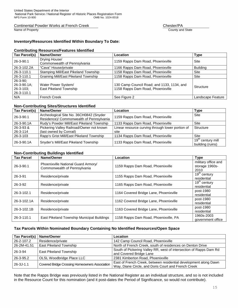
Inventory/Resources Identified Within Boundary To Date: Contributing Resources/Features Identified Tax Parcel(s) Name/Owner Location Type
26-3-90.1 Drying House/ Commonwealth of Pennsylvania 1159 Rapps Dam Road, Phoenixville Site
26-3-102.2A “Cava” House/private 1166 Rapps Dam Road, Phoenixville Building 26-3-110.1 Stamping Mill/East Pikeland Township 1158 Rapps Dam Road, Phoenixville Site 26-3-110.1 Graining Mill/East Pikeland Township 1158 Rapps Dam Road, Phoenixville Site 26-3-90; 26-3-90.1A; 26-3-103; 26-3-110.1
Water Power System/ East Pikeland Township
130 Camp Council Road; and 1133, 1134, and 1158 Rapps Dam Road, Phoenixville Structure
N/A French Creek See Figure 2 Landscape Feature Non-Contributing Sites/Structures Identified Tax Parcel(s) Name/Owner Location Type
26-3-90.1 Archeological Site No. 36CH0842 (Snyder Residence)/ Commonwealth of Pennsylvania 1159 Rapps Dam Road, Phoenixville Site
26-3-90.1A Rudy’s Powder Mill/East Pikeland Township 1133 Rapps Dam Road, Phoenixville Site 26-3-93 & 26-3-114
Pickering Valley Railroad/Owner not known (last owned by Conrail)
Linear resource curving through lower portion of site
Structure
26-3-103 Rapp’s Grist Mill/East Pikeland Township 1134 Rapps Dam Road, Phoenixville Site
26-3-90.1A Snyder’s Mill/East Pikeland Township 1133 Rapps Dam Road, Phoenixville 19th century mill building (ruins)
Non-Contributing Buildings Identified Tax Parcel Name/Owner Location Type
26-3-90.1 Phoenixville National Guard Armory/ Commonwealth of Pennsylvania 1159 Rapps Dam Road, Phoenixville
military office and storage 1960s-2010
26-3-91 Residence/private 1155 Rapps Dam Road, Phoenixville 19th century residential
26-3-92 Residence/private 1165 Rapps Dam Road, Phoenixville 19th century residential
26-3-102.1 Residence/private 1164 Covered Bridge Lane, Phoenixville post-1980 residential
26-3-102.1A Residence/private 1162 Covered Bridge Lane, Phoenixville post-1980 residential
26-3-102.1B Residence/private 1163 Covered Bridge Lane, Phoenixville post-1980 residential
26-3-110.1 East Pikeland Township Municipal Buildings 1158 Rapps Dam Road, Phoenixville, PA 1960s-2003 government office
Tax Parcels Within Nominated Boundary Containing No Identified Resources/Open Space Tax Parcel(s) Name/Owner Location 26-2-107.2 Residence/private 142 Camp Council Road, Phoenixville 26-2M-41.51 East Pikeland Township North of French Creek, south of residences on Denton Drive
26-3-94 East Pikeland Township South of Pickering Valley RR, west of intersection of Rapps Dam Rd and Covered Bridge Lane
26-3-95.2 OLSL Woodbridge Place LLC 2381 Kimberton Road, Phoenixville
26-3J-1.1 Covered Bridge Crossing Homeowners Association East of French Creek, between residential development along Dawn Way, Diane Circle, and Doris Court and French Creek
Note that the Rapps Bridge was previously listed in the National Register as an individual structure, and so is not included in the Resource Count for this nomination (and it post-dates the Period of Significance, so would not contribute).
United States Department of the Interior National Park Service / National Register of Historic Places Registration Form NPS Form 10-900 OMB No. 1024-0018 Continental Powder Works at French Creek Chester/PA Name of Property County and State
16
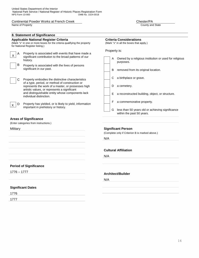
8. Statement of SignificanceApplicable National Register Criteria (Mark "x" in one or more boxes for the criteria qualifying the property for National Register listing.)
X A Property is associated with events that have made a significant contribution to the broad patterns of our history.
B Property is associated with the lives of persons
significant in our past.
C Property embodies the distinctive characteristics
of a type, period, or method of construction or represents the work of a master, or possesses high artistic values, or represents a significant and distinguishable entity whose components lack individual distinction.
X D Property has yielded, or is likely to yield, information important in prehistory or history.
Criteria Considerations (Mark "x" in all the boxes that apply.) Property is:
A
Owned by a religious institution or used for religious purposes.
B removed from its original location.
C a birthplace or grave.
D a cemetery.
E a reconstructed building, object, or structure.
F a commemorative property.
G less than 50 years old or achieving significance
within the past 50 years.
Areas of Significance (Enter categories from instructions.)
Military
Period of Significance
1776 – 1777
Significant Dates
1776
1777
Significant Person (Complete only if Criterion B is marked above.)
N/A
Cultural Affiliation
N/A
Architect/Builder
N/A
United States Department of the Interior National Park Service / National Register of Historic Places Registration Form NPS Form 10-900 OMB No. 1024-0018 Continental Powder Works at French Creek Chester/PA Name of Property County and State
17
Statement of Significance Summary Paragraph The Continental Powder Mill at French Creek Site is eligible for the National Register in the area of Military History under Criterion A for its association with the American Revolution. The Site is also eligible under Criterion D for the ability and potential to yield information on activities on the property as gunpowder and gun manufacturer during the Revolutionary War. The period of significance is from 1776 – 1777. The site was selected in April 1776 by the Committee of Safety under the direction of the Continental Congress for the erection of the state’s only government-built gunpowder mill. A gun factory was added in December 1776. At its peak, the site was producing approximately two tons of gunpowder each week, and thousands of gunlocks. Threatened by advancing Crown Forces in September 1777, the majority of the military stores and supplies were removed from the site under orders from George Washington, just days before a Crown Forces detachment of the Hessian Field Jäger Corps and British Light Infantry destroyed the buildings and remaining military stores. At the beginning of the war, only one works in the American colonies was producing a significant amount of gunpowder: the Frankford Mill, which was just outside Philadelphia and owned by Oswald Eve and his son (Salay 1975:423). Other than the Continental Powder Works at French Creek, works begun elsewhere in Pennsylvania and in the other colonies were private enterprises that received monetary and material support from their respective colonial governments; yet, none were the size and scale of the works at French Creek (Reynolds 1965; Salay 1975; Risch 1981). No other purpose-built powder works are known to have been established, owned, and operated by a colonial government. Typically, the colonies encouraged production by providing money to convert mills to produce gunpowder, provided raw materials, and guaranteed purchase of powder at a fixed price. Investigations to date have yielded information on specific identified features related to the powder works, including three sites: the stamping mill; the graining mill; and one of the drying houses; and one structure, the water power system and its associated landscape feature, the French Creek itself. Also identified is a building, the Cava House, believed to be the residence of someone associated with the Powder Works, possibly the facility’s manager. Eighteenth-century artifacts, some related to military activities or weaponry, have also been recovered. Further archeological investigations within the core area of the site are likely to yield additional information related to the activities and processes associated with the resources investigated to date, as well as those that have yet to be explored archeologically. Archeological studies of each of the currently identified site foundations (stamping mill, graining mill, and drying house) could focus on the methods of construction, the functions of the buildings, the methods of destruction, and whether, during the short period of time the Continental Powder Works operated, substantial changes or modifications to the fabric of the buildings was completed. ________________________________________________________________________________________________________________________ Narrative Statement of Significance The Pennsylvania Committee of Safety, with the approval of the Second Continental Congress, directed that a powder works be constructed within 50 miles of Philadelphia, and authorized the purchase of land on French Creek in April 1776. Construction of a gun powder works complex began the same month. Erection of a gun factory was authorized in December 1776. The stamping mill was destroyed by explosion in March 1777, but the remaining buildings and structures—most importantly the gun factory—continued operation. At its peak, the site was producing each week approximately two tons of gunpowder, and thousands of gunlocks. Threatened by advancing Crown Forces in September 1777, the majority of the military stores and supplies were removed from the site under orders from George Washington, just days before a Crown Forces detachment of the Hessian Field Jäger Corps and British Light Infantry destroyed the factory and remaining military stores. Assessment The early years of the American War for Independence found a new revolutionary government attempting to undertake a war with virtually no supply or logistics abilities against a well-established European power. Between 1775 and 1777 the American forces were chronically short of gunpowder and weapons, both critical needs for carrying on the war effort (Risch 1981:339-343; Stephenson 1925). Powder supplies from foreign sources were not adequate, nor were domestic sources of supply. Initially, the domestic sources throughout the colonies were found to be in disrepair and totally unable to provide the amount of powder needed for the army and navy. In an effort to address these shortages, state
United States Department of the Interior National Park Service / National Register of Historic Places Registration Form NPS Form 10-900 OMB No. 1024-0018 Continental Powder Works at French Creek Chester/PA Name of Property County and State
18
governments and the Continental Congress authorized, encouraged, and funded the development of the powder and armament industries (Risch 1981342-346). In Pennsylvania privately-owned powder manufactories were established, as well as the one-of-a-kind, large Commonwealth-owned Continental Powder Works at French Creek (Salay 1975). Over the course of approximately a year-and a-half, from April 1776 until September 1777, the works strove to fulfill the gunpowder needs of the nascent United States. For the Continental Powder Works, historical records indicate the number and function of buildings. A large stamping mill, the largest built in Pennsylvania during the American Revolution (Salay 1975), was the principal building associated with powder manufacture. Also present was an associated graining mill. Other buildings included at least four drying houses, a saltpeter house, a guard house, and a dwelling house. All of these buildings are mentioned in the depositions taken in March 1777 after the explosion that destroyed the stamping mill (Hazard 1853b:255-257,261). As with the powder supply, the domestic supply of weapons – muskets, rifles, bayonets, pistols, cannons – were completely inadequate in the first two years of the war (Risch 1981:346-356). Until the supply of foreign weapons, particularly shipments of French and Spanish muskets, began to provide large numbers of guns in 1777, the domestic gun factories were critical to the war effort. In colonies like Virginia (at Fredericksburg) and Pennsylvania (the gun factory first in Philadelphia and later at French Creek), the production of guns was all-important during the initial years of the conflict. It was reported in early January 1777 that the gun factory at French Creek included smith shops and other buildings, but these were not enumerated (Pennypacker 1872:94). An earlier statement (March 1776) from a Philadelphia gunsmith, John Nicholson, suggests what buildings should have been present at the French Creek site, and these included a boring and grinding mill (a building that would require water power, part of the gun factory), a lock forging shop, a shop for lock filers and for forging and hardening springs, a shop for stockers, a brass casting shop, a shop for forging bayonets and steel ramrods, a shop for “swivels, trickers, pins, and springs,” and a shop to manufacture the finished product (Cremers 1989:90). In addition to these manufacturing-related buildings, Nicholson also suggested a dwelling house. It is not known if all of these buildings were established at French Creek, but the boring and grinding mill was in place by December 1776 (Salay 1975), and the accounts by the Crown Forces mention “armorers shops and storehouses” and “a rifle factory” as buildings that were destroyed on 22 September 1777 (Ewald 1979:90; British Light Infantry 1777). From a military perspective the intent of siting the powder works complex was to secure the production of gunpowder and the repair and production of weaponry at a location that limited threats from Crown forces while maintaining the ability to supply American forces without inordinate delays. Manufacturing concerns required that the location have a sufficient fall of water to power mills, as well as having ready access to the raw materials needed for operations. Once a suitable location was found, the necessary infrastructure was designed in a manner considered appropriate for the manufacture of gunpowder, and later arms production and distribution. In January 1776 the Committee of Safety of the Second Continental Congress directed that a powder works be built within 50 miles of Philadelphia. Land was acquired along French Creek by April 1776 and a powder works constructed, it becoming operational in June 1776. The works were overseen by Peter DeHaven, a Philadelphia gunsmith, who by early 1777 resided at the works. A June 3, 1776 report to the Committee of Safety (Hazard 1853a:765-766) described the powder works complex as consisting of a powder mill (or stamping mill), a graining mill, a saltpeter house, and four drying houses. Both the stamping mill and the graining mill required water power. By early winter 1777 a gun factory, including a boring and a grinding mill for the manufacture of gun barrels, was also in place at French Creek, and the threat of raids by the British forces led to the construction of barracks in January 1777 to house a company of militia charged with protecting the works (Moore 2011; Salay 1975:437). The order relocating the gun factory in Philadelphia to the French Creek site was made in response to the threat of Crown Forces activities in New Jersey, and this threat was only removed by the military actions at Trenton (26 December 1776) and Princeton (3 January 1777). By early 1777 the Powder Works was a busy, bustling place and had become the center of major powder and arms production in Pennsylvania. The complex included a stamping mill, a graining mill, a saltpeter house, four drying houses, a gun factory, smith shops (unspecified number), other support buildings or structures, a militia barracks of some sort, and a dwelling house. The works were carried on here with success until 10 March 1777, when an explosion destroyed the stamping mill.
United States Department of the Interior National Park Service / National Register of Historic Places Registration Form NPS Form 10-900 OMB No. 1024-0018 Continental Powder Works at French Creek Chester/PA Name of Property County and State
19
During the Philadelphia campaign in the fall, Crown forces neared Downingtown in late September 1777. The powder works complex was abandoned, with the gun works relocated to Hummelstown, Pennsylvania, and powder stores transported to Bethlehem, Pennsylvania. Shortly thereafter, on September 22, 1777, a Crown Forces detachment reconnoitered to French Creek and exchanged fire with the defenders of the powder works complex. Brushing aside the American defense, the Crown forces entered the “village” described by one contemporary as deserted and consisting of forty or fifty buildings. The ruins of the powder magazine were noted, and the Crown forces destroyed several thousand weapons that were not removed to safety and set fire to the gun factory and the village. The complex was not reoccupied during the American Revolution, although at least two attempts to acquire the property are recorded in 1779, at which time the land was described as “waste land and a common” (Cremers 1989:91). Following the war, the land associated with the powder works was farmed, while the mill race was adapted to serve first a powder mill, and later mills oriented toward processing seeds, grain and lumber. During the first half of the nineteenth century, the Snyder family, likely either Henry or Thomas, constructed a house and barn on the west side of Rapps Dam Road, south and east of the raceway. From 1855 to 1858, Dr. Oberholtzer operated a powder mill along a tributary to French Creek at the southwest end of the Powder Mill Tract. An explosion in 1858 destroyed the mill. At some time during the nineteenth century, likely the latter half, two houses were built along the west side of Rapps Dam Road. In 1871, the Pickering Valley Railroad was built through a portion of the tract that held the powder works complex (Bartman and Kindig 1990; Clegg n.d.; Moore 2011; Rapp 1938). The last remaining Powder Works drying house was demolished c.1925. In the 1930s, the Borough of Phoenixville purchased the portion of the Powder Mill Tract that had been held by the Snyder family with the intent of taking water from French Creek for municipal use. Finding that the water rights were owned by the Phoenixville Iron Works, the parcel instead became a park in 1938. The same year, a grist mill on the east side of Rapps Dam Road, built in 1860 by Benjamin Hartman, was destroyed by fire. Circa 1964, the Commonwealth of Pennsylvania acquired the tract of land holding the Snyder house and barn, and established the Phoenixville National Guard Armory. During the same period, the township constructed a municipal building on the east side of Rapps Dam Road. In the first decade of the twenty-first century, the building was remodeled and expanded, and maintenance buildings were constructed a short distance to the southeast. During the 1980s, the portion of the Powder Mill Tract south of the railroad underwent extensive residential development. Research Questions Answered and Applicable to Future Investigations Investigations to date have yielded information on three buildings related to the powder works: 1) the stamping mill; 2) the graining mill; and 3) one of the drying houses, and one structure, the raceway (see Figure 2, and Photographs 1, 2, 6-9, 11, and 12). Eighteenth-century artifacts, some related to military activities or weaponry, have also been recovered. Further archeological investigations within the core area of the site are likely to yield additional information related to the activities and processes associated with the buildings investigated to date, as well as those that have yet to be explored archeologically (see Figures 4 and 5). Archeological studies of each of the currently identified foundations (stamping mill, graining mill, and drying house) could focus on the methods of construction, the functions of the buildings, the methods of destruction, and whether, during the short period of time the Continental Powder Works operated, substantial changes or modifications to the fabric of the buildings was completed. Further archeological investigations of the remainder of the Powder Mill tract could also work to locate the heretofore elusive gun factory, a resource that would almost certainly leave behind a distinctive archeological signature. Does evidence persist of the gun factory, either structurally, or in the form of artifacts patterning? During the eighteenth century the manufacture of guns was a multi-set process conducted by several artisans and journeymen. Gun making for military arms required barrel welders, forgers for locks, lock filers, brass casters, and stockers (Bailey 2009:94-96; Cooper 1988:38-39). The historical record suggests that the Powder Works employed at least nineteen men by January 1777 (Hazard 1853b:155). These specialists required a boring and grinding mill, a shop for forging locks, shops for lock filers, shops for gun stockers, a brass casting shop, a forge for the smaller items of the weapon, such as springs, screws, pins, and swivels, and a shop where the finished product was assembled. Within the Powder Mill Tract, evidence of this range of shops and forges should be present. The archeological evidence may consist of forge bases and building foundations, and perhaps soil chemical signatures indicative of metal working. Artifacts associated with gun manufacturing will likely
United States Department of the Interior National Park Service / National Register of Historic Places Registration Form NPS Form 10-900 OMB No. 1024-0018 Continental Powder Works at French Creek Chester/PA Name of Property County and State
20
include waste products, not finished products, and perhaps weaponry that was destroyed by the Crown forces in September of 1777. Additional archeological investigations could also focus on attempting to locate the barracks and associated buildings related to the personnel of the complex. It is known that soon after the Powder Works was functioning, a barracks for a powder mill guard was built. In December 1776 the barracks was ordered, and it was nearly complete in January 1777. The garrison at French Creek was composed initially of Pennsylvania militia, and later historical evidence suggests that Continental troops took over the role (Graham 2011; Trussell 1977). Whether the barracks was a single building or multiple buildings is not known, and a later map drawn in 1946 suggests the presence of a “village” of seventeen separate buildings in the floodplain adjacent to French Creek (Ellis 1946; Bartmann and Kindig 1990). In addition to the barracks, documentary evidence indicates a “powder masters” house. It is possible that the “Cava” House served this purpose. Investigations of the house and yard could aid in determining if the property had in fact been part of the powder works complex. Not yet identified within the core area are the remains of the saltpeter house, described as measuring 21 by 27 feet and housing twelve kettles. In addition, the location indicated in documents as holding the magazine, or storehouse, has yet to be investigated for remains of the building.
United States Department of the Interior National Park Service / National Register of Historic Places Registration Form NPS Form 10-900 OMB No. 1024-0018 Continental Powder Works at French Creek Chester/PA Name of Property County and State
21
9. Major Bibliographical References "American Archives, Documents of the American Revolution, 1774 – 1776”, Northern Illinois University Libraries. http:// dig.lib.niu.edu/amarch/. Anderson, Isaac 1875 “Historical Sketch of Charlestown Township, Chester County, Pennsylvania.” Potter’s American Monthly: An
Illustrated Magazine of History, Literature, Science and Art, 4 & 5:26 – 31. Andrews, Susan C. and Michael D. Richmond 2005 A Phase IB Archaeological Survey of the Phoenixville Armory. Prepared for the Department of Military and
Veterans Affairs, Environmental Section, Pennsylvania National Guard by AMEC Earth and Environmental. Bailey, De Witt 2009 Small Arms of the British Forces in America, 1664-1815. Andrew Mowbray Publishers, Inc., Woonsocket, Rhode Island. Bartmann, Robert E., AICP and Steven Kindig 1990 An Evaluation of Snyder’s Mill for East Pikeland Township, Chester County, Pennsylvania. Prepared for the East
Pikeland Township Board of Supervisors and the East Pikeland Township Environmental Advisory Council by the authors.
Baumann, Roland M. ed. 1978 Records of Pennsylvania’s Revolutionary Governments, 1775-1790. Pennsylvania Historical and Museum
Commission, Harrisburg, Pennsylvania. Benedict, Tod L. and Wade P. Catts 2000 A Phase I Archeological Survey of the Proposed Location of a Cellular Telecommunications Tower, East Pikeland
Township, Chester County, Pennsylvania. Prepared for Nextel Communications, Inc. by John Milner Associates, Inc.
British Light Infantry. A Memorandum List for 1777.George Washington Papers, Reel 118, Library of Congress. (available
on line). Also see, Thomas J. McGuire, 2000, Battle of Paoli. Stackpole Books, Mechanicsburg, Pennsylvania. Chester County Recorder of Deeds Office Chester County, Pennsylvania Tax Records, West Chester County Archives 1799 – 1925. Chester County Historical Society, Clipping File, West Chester, Pennsylvania. Clegg, Miriam 2007 “Rapp’s Bridge and the Continental Powder Mill.” The Historical Society of the Phoenixville Area, 30(3):2 – 5. Cooper, Carolyn C. 1988 “A Whole Battalion of Stockers”: Thomas Blachard’s Production Line and Hand Labor at Springfield Armory. IA:
Journal of the Society for Industrial Archeology 14(1):37-58. Crackel, Theodore J., ed. 2001 The Papers of George Washington. University of Virginia Press, Charlottesville. Cremers, Estelle 1989 30,000 Acres, Vincent and Pikeland Townships 1686 to 1850. The New Mediterranean Sea Company, Pottstown,
Pennsylvania.
United States Department of the Interior National Park Service / National Register of Historic Places Registration Form NPS Form 10-900 OMB No. 1024-0018 Continental Powder Works at French Creek Chester/PA Name of Property County and State
22
Ewald, Captain Johann 1979 Diary of the American War, translated and edited by Joseph P. Tustin. Yale University Press, New Haven. Futhey, J. Smith, and Gilbert Cope 1881 History of Chester County, Pennsylvania, with Genealogical and Biographical Sketches. Louis H. Everts,
Philadelphia. Graham, Dan 2011 French Creek Continental Powder Works and Gun Manufactory, Chester County, Pennsylvania. The Local
Historian, a Publication of the Tri-County Heritage Society (Fall):1-9. Hazard Samuel, ed. 1853a Pennsylvania Archives, commencing 1760. Vol. 4. Joseph Severns and Company, Philadelphia. 1853b Pennsylvania Archives, commencing 1776. Vol. 5. Joseph Severns and Company, Philadelphia. Jordan, John W 1888 “Bethlehem During the Revolution Extracts from the Diaries in the Moravian Archives at Bethlehem.” The
Pennsylvania Magazine of History and Biography, 12(4):404 – 405. Kunkle, Merrill 1963 Soil Survey of Chester and Delaware Counties, Pennsylvania. Soil Conservation Service, United States
Department of Agriculture, Washington, D.C. Mancl, Tim, Peter A. Leach and Wade P. Catts 2011 Archeological Investigations at the French Creek Mill Complex, East Pikeland, Pennsylvania. Prepared for the
East Pikeland Township by John Milner Associates, Inc. Mancl, Tim, Peter A. Leach, Elizabeth LaVigne, and Wade P. Catts 2012 Archeological Investigations of the Continental Powder Works at French Creek (Archeological Site No.
36CH0842). American Battlefield Protection Program Grant No. GA-2255-11-007 Prepared for the East Pikeland Township by John Milner Associates, Inc.
Moore, Patricia S. 2011 Draft National Register Nomination Form. Continental Powder Mill at French Creek. On file with the East Pikeland
Historical Commission. Pennypacker, Samuel Whitaker 1872 Annals of Phoenixville and its Vicinity: From the Settlement to the Year 1871, Giving the Origin and Growth of the
Borough, with Information Concerning the Adjacent Townships of Chester and Montgomery Counties and the Valley of the Schuylkill. Bavis & Pennypacker, Philadelphia.
Pennsylvania State Archives, Harrisburg, PA. RG-4 Container for the Office of the Comptroller General, Commissary
Accounts, 1775 – 1792, Box 1: 1775 – 1777 Robert Towers – Commissary of the Magazine and Military Stores. Pikeland Map, surveyed by Cadwalder Evans, Jr. under the direction of Benjamin Chew, Alexander Wilcox, and Benjamin
Chew, Jr., May and June 1790, Chester County Historical Society Library, in the map section under “East Pikeland”.
Rapp, Joseph P.
1938, Jan. 6 Readers’ Column. The Daily Republican. Phoenixville, Pennsylvania. In the clippings file at the Chester County Historical Society.
United States Department of the Interior National Park Service / National Register of Historic Places Registration Form NPS Form 10-900 OMB No. 1024-0018 Continental Powder Works at French Creek Chester/PA Name of Property County and State
23
Reynolds, Donald E. 1965 Ammunition supply in revolutionary Virginia. Virginia Magazine of History and Biography 73:56-77. Risch, Erna. 1981 Supplying Washington’s Army. U.S. Army Center for Military History, Washington, D.C. Ross, Howard DeHaven. 1949. “The “Continental Powder Mill” on French Creek Near Valley Forge, and the “Provincial Gun Factory” at 3d &
Cherry Streets in Philadelphia, Conducted by Peter DeHaven and His Son, Hugh” The Picket Post p. 16 – 23, 35. 1929 History of the DeHaven Family. Pandick Press, New York. Rowan University, Campbell Library, Frank H. Stewart Room. Gunpowder Papers.
a. Letter from Owen Biddle to John Ladd Howell, 1739-1785, Philadelphia. May 29, 1776. b. Cowperthwaite and Biddle. Powder Mill Documents. Diagram of Powder Mill.
Salay, David. 1975 “Production of Gunpowder in Pennsylvania During the Revolution.” The Pennsylvania Magazine of History and
Biography. 99(4):435 – 439. Schenawolf, Harry 2012 Gunpowder and its Supply in the American Revolutionary War. (http://www.harryschenawolf.com/211/) Smith, Paul H., ed. 1976 Letters of Delegates to Congress, 1774 – 1789. Library of Congress, Washington D.C. State of Pennsylvania 1852 Minutes of the Supreme Executive Council of Pennsylvania, From Its Organization to the Termination of the
Revolution, Vol. XI. Theo. Fenn & Co., Harrisburg, Pennsylvania. Stephenson, Orlando W. 1925 ”The Supply of Gun Powder in 1776.” American Historical Review 30(2):271-281. Trussell, John B.B., Jr. 1977 Pennsylvania Line: Regimental Organization and Operations, 1776-1783. Pennsylvania Historical and Museum
Commission, Harrisburg, Pennsylvania. United States Revolutionary War Pension and Bounty Land Warrant Applications, 1800-1900, microfilm publication M804
(Washington D.C.: National Archives and Records Administration, n.d.), roll 971993, application of Michael Reagan, No. S35614.
Previous documentation on file (NPS): Primary location of additional data:
preliminary determination of individual listing (36 CFR 67 has been State Historic Preservation Office requested) X Other State agency previously listed in the National Register Federal agency previously determined eligible by the National Register Local government designated a National Historic Landmark University recorded by Historic American Buildings Survey #____________ X Other
recorded by Historic American Engineering Record # __________ Name of repository: Pennsylvania State Archives recorded by Historic American Landscape Survey # ___________ David Library of American Revolution Historic Resources Survey Number (if assigned): NA
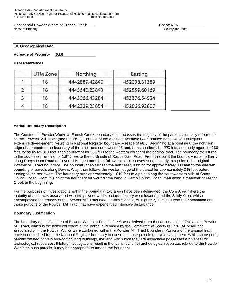
United States Department of the Interior National Park Service / National Register of Historic Places Registration Form NPS Form 10-900 OMB No. 1024-0018 Continental Powder Works at French Creek Chester/PA Name of Property County and State
24
10. Geographical Data Acreage of Property 98.6 UTM References
Verbal Boundary Description The Continental Powder Works at French Creek boundary encompasses the majority of the parcel historically referred to as the “Powder Mill Tract” (see Figure 2). Portions of the original tract have been omitted because of subsequent extensive development, resulting in National Register boundary acreage of 98.6. Beginning at a point near the northern edge of a meander, the boundary of the tract runs southwest 435 feet, turns southerly for 220 feet, southerly again for 250 feet, westerly for 310 feet, then southwest for 560 feet to the western corner of the original tract. The boundary then turns to the southeast, running for 1,875 feet to the north side of Rapps Dam Road. From this point the boundary runs northerly along Rapps Dam Road to Covered Bridge Lane, then follows several courses southeasterly to a point in the original Powder Mill Tract boundary. The boundary then turns to the northeast, running for approximately 830 feet to the western boundary of parcels along Dawns Way, then follows the western edge of the parcel for approximately 345 feet before turning to the northwest. The boundary runs approximately 1,810 feet to a point along the southwestern side of Camp Council Road. From this point the boundary follows first the bend in Camp Council Road, then along a meander of French Creek to the beginning. For the purposes of investigations within the boundary, two areas have been delineated: the Core Area, where the majority of resources associated with the powder works and gun factory were located, and the Study Area, which encompassed the entirety of the Powder Mill Tract (see Figures 5 and 7, cf. Figure 2). Omitted from the nomination are those portions of the Powder Mill Tract that have experienced intensive disturbance. Boundary Justification The boundary of the Continental Powder Works at French Creek was derived from that delineated in 1790 as the Powder Mill Tract, which is the historical extent of the parcel purchased by the Committee of Safety in 1776. All resources associated with the Powder Works were contained within the Powder Mill Tract Boundary. Portions of the original tract have been omitted from the National Register boundary because of subsequent intensive development. While some of the parcels omitted contain non-contributing buildings, the land with which they are associated possesses a potential for archeological resources. If future investigations result in the identification of archeological resources related to the Powder Works on such parcels, it may be appropriate to amend the boundary.
United States Department of the Interior National Park Service / National Register of Historic Places Registration Form NPS Form 10-900 OMB No. 1024-0018 Continental Powder Works at French Creek Chester/PA Name of Property County and State
25
11. Form Prepared By
name/title Patricia S. Moore, Tim Mancl, and Wade P. Catts organization East Pikeland Township Historical Commission date February 12, 2015
street & number 1158 Rapps Dam Road telephone 610-933-1770
city or town Phoenixville state PA zip code 19460
e-mail Photographs: Submit clear and descriptive photographs. The size of each image must be 1600x1200 pixels at 300 ppi (pixels per inch) or larger. Key all photographs to the sketch map. Name of Property: Continental Powder Works at French Creek City or Vicinity: East Pikeland Township County: Chester State: Pennsylvania Photographer: Tim Mancl, Wade Catts and Patricia Moore Date Photographed: Spring and Summer of 2012 Description of Photograph(s) and number: (refer to Figure 2 for the location of photograph subjects) Photograph 1. View of a post-Continental Powder Mill sluice gate at the dam. Note the pockets in the stonework, which
likely relate to the superstructure of an earlier gate. Photograph 2. Part of the ruins of Snyder’s Barn, which is associated with Archeological Site 36CH0842 (non-
contributing). Photograph 3. View of a post-Continental Powder Mill sluice gate and possible wheel pit at the location of the ruins of
Rudy’s Powder Mill, looking west. A tailrace runs back to French Creek from this location. The primary raceway that runs to Rapps Dam Road is to the south.
Photograph 4, The partially reconstructed ruins of Synders Mill, looking north. The raceway is on the foreground. In the
background to the east is Rapps Covered Bridge. Photograph 5. View of a buried section of the raceway southeast of Rapps Dam Road as exposed in a trench cut, looking
northwest. Photograph 6. View along the buried section of the raceway (blue tape) showing the locations of the sites of the graining
mill (foreground) and the stamping mill (background), looking southeast. Photograph 7. View of the site of the Stamping Mill, looking north. Photograph 8. View of the foundation wall of the Graining Mill, looking west. Photograph 9: Ramrod thimble found during the metal detection survey. Photograph 10: Nails recovered from the site of the interior of the Graining Mill.
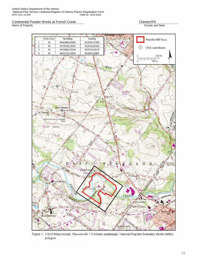
United States Department of the Interior National Park Service / National Register of Historic Places Registration Form NPS Form 10-900 OMB No. 1024-0018 Continental Powder Works at French Creek Chester/PA Name of Property County and State
26
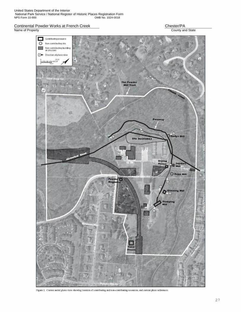
United States Department of the Interior National Park Service / National Register of Historic Places Registration Form NPS Form 10-900 OMB No. 1024-0018 Continental Powder Works at French Creek Chester/PA Name of Property County and State
27
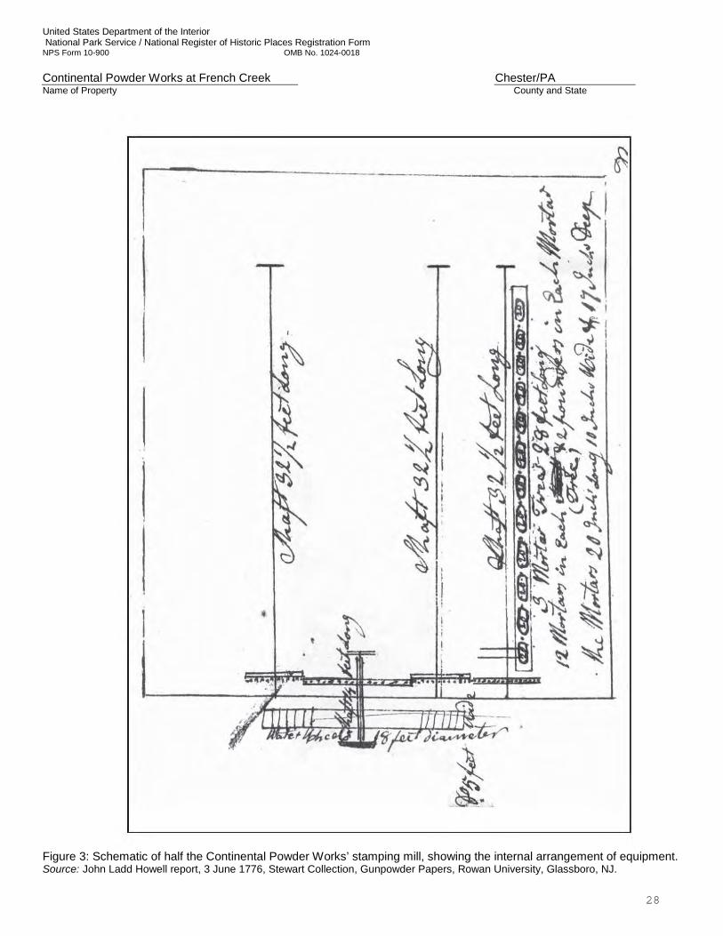
United States Department of the Interior National Park Service / National Register of Historic Places Registration Form NPS Form 10-900 OMB No. 1024-0018 Continental Powder Works at French Creek Chester/PA Name of Property County and State
28
Figure 3: Schematic of half the Continental Powder Works’ stamping mill, showing the internal arrangement of equipment. Source: John Ladd Howell report, 3 June 1776, Stewart Collection, Gunpowder Papers, Rowan University, Glassboro, NJ.
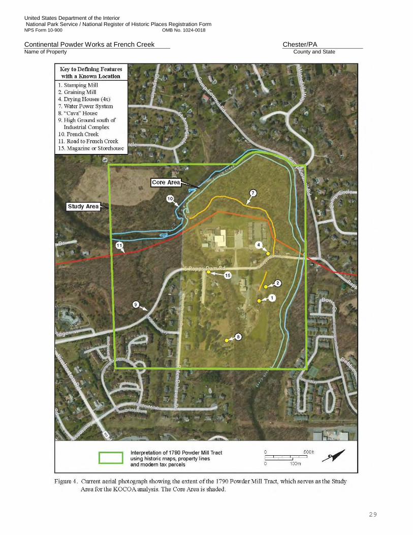
United States Department of the Interior National Park Service / National Register of Historic Places Registration Form NPS Form 10-900 OMB No. 1024-0018 Continental Powder Works at French Creek Chester/PA Name of Property County and State
29
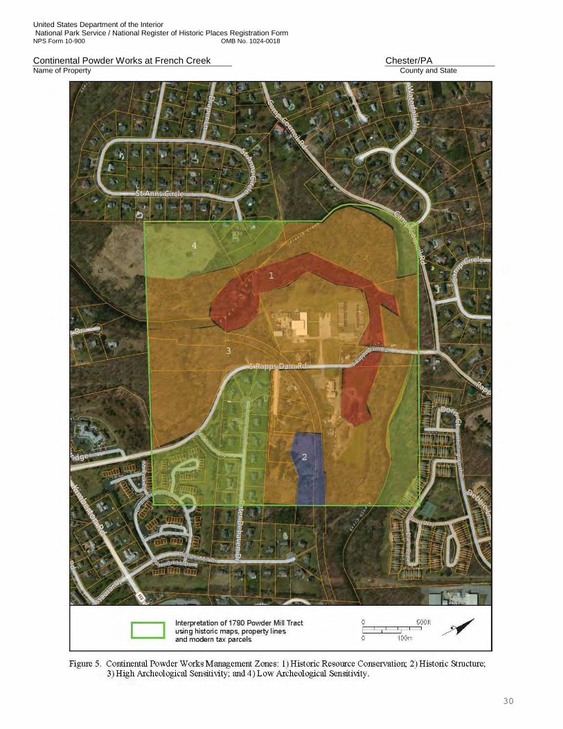
United States Department of the Interior National Park Service / National Register of Historic Places Registration Form NPS Form 10-900 OMB No. 1024-0018 Continental Powder Works at French Creek Chester/PA Name of Property County and State
30
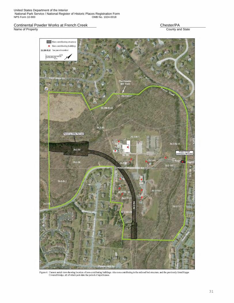
United States Department of the Interior National Park Service / National Register of Historic Places Registration Form NPS Form 10-900 OMB No. 1024-0018 Continental Powder Works at French Creek Chester/PA Name of Property County and State
31
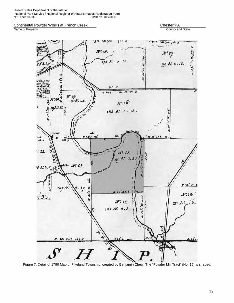
United States Department of the Interior National Park Service / National Register of Historic Places Registration Form NPS Form 10-900 OMB No. 1024-0018 Continental Powder Works at French Creek Chester/PA Name of Property County and State
32
Figure 7. Detail of 1790 Map of Pikeland Township, created by Benjamin Chew. The “Powder Mill Tract” (No. 15) is shaded.
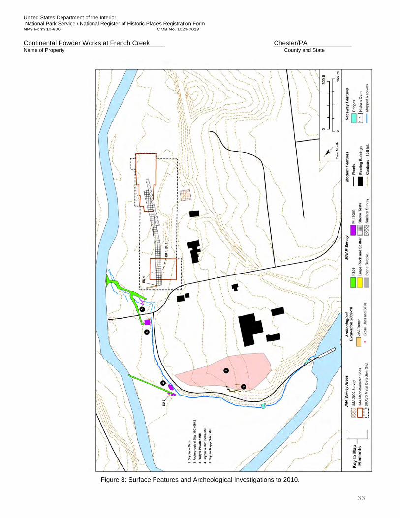
United States Department of the Interior National Park Service / National Register of Historic Places Registration Form NPS Form 10-900 OMB No. 1024-0018 Continental Powder Works at French Creek Chester/PA Name of Property County and State
33
Figure 8: Surface Features and Archeological Investigations to 2010.
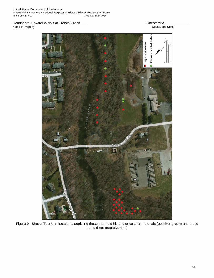
United States Department of the Interior National Park Service / National Register of Historic Places Registration Form NPS Form 10-900 OMB No. 1024-0018 Continental Powder Works at French Creek Chester/PA Name of Property County and State
34
Figure 9: Shovel Test Unit locations, depicting those that held historic or cultural materials (positive=green) and those
that did not (negative=red)
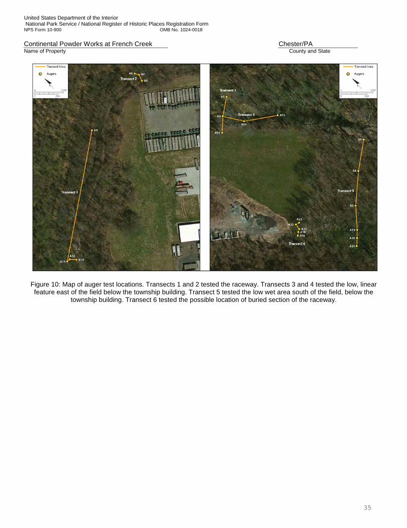
United States Department of the Interior National Park Service / National Register of Historic Places Registration Form NPS Form 10-900 OMB No. 1024-0018 Continental Powder Works at French Creek Chester/PA Name of Property County and State
35
Figure 10: Map of auger test locations. Transects 1 and 2 tested the raceway. Transects 3 and 4 tested the low, linear feature east of the field below the township building. Transect 5 tested the low wet area south of the field, below the
township building. Transect 6 tested the possible location of buried section of the raceway.
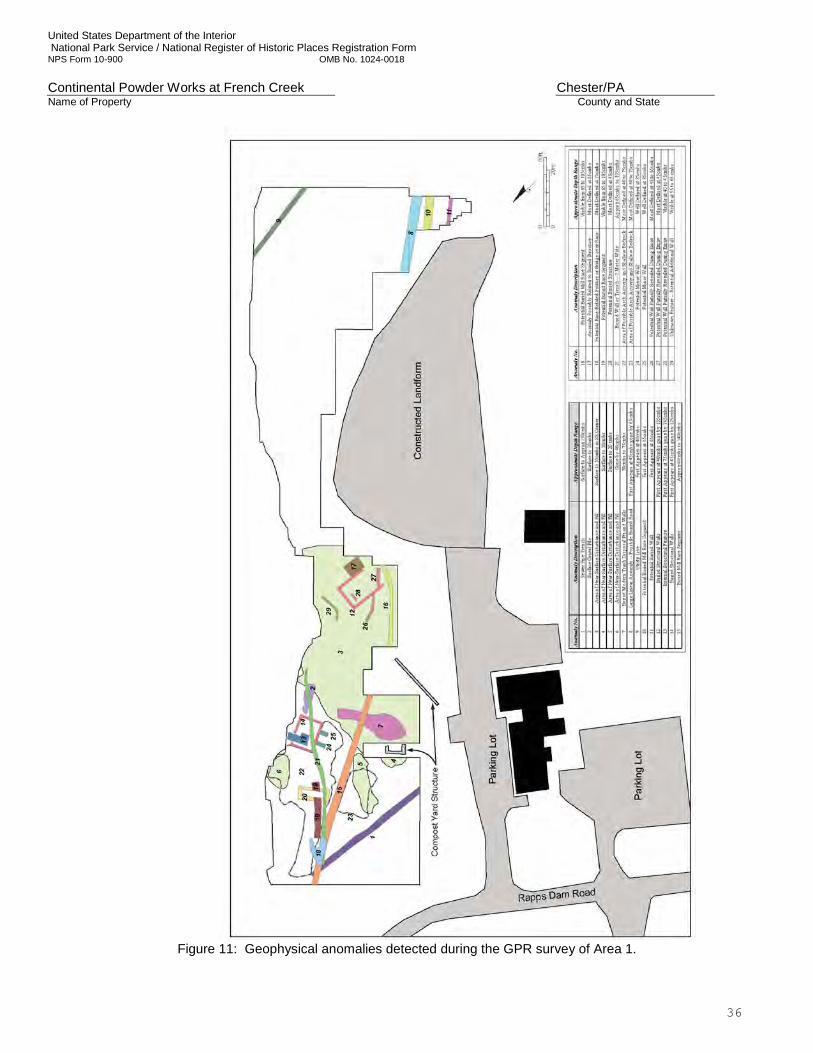
United States Department of the Interior National Park Service / National Register of Historic Places Registration Form NPS Form 10-900 OMB No. 1024-0018 Continental Powder Works at French Creek Chester/PA Name of Property County and State
36
Figure 11: Geophysical anomalies detected during the GPR survey of Area 1.
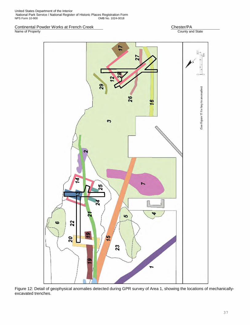
United States Department of the Interior National Park Service / National Register of Historic Places Registration Form NPS Form 10-900 OMB No. 1024-0018 Continental Powder Works at French Creek Chester/PA Name of Property County and State
37
Figure 12: Detail of geophysical anomalies detected during GPR survey of Area 1, showing the locations of mechanically-excavated trenches.
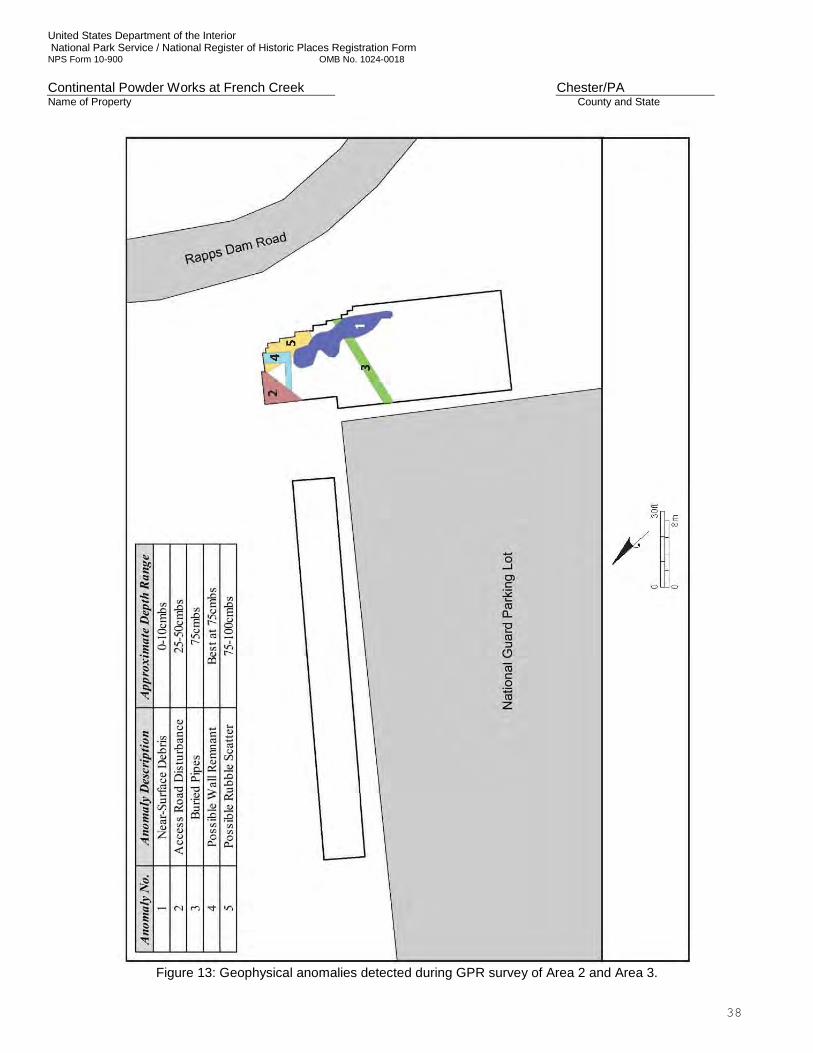
United States Department of the Interior National Park Service / National Register of Historic Places Registration Form NPS Form 10-900 OMB No. 1024-0018 Continental Powder Works at French Creek Chester/PA Name of Property County and State
38
Figure 13: Geophysical anomalies detected during GPR survey of Area 2 and Area 3.
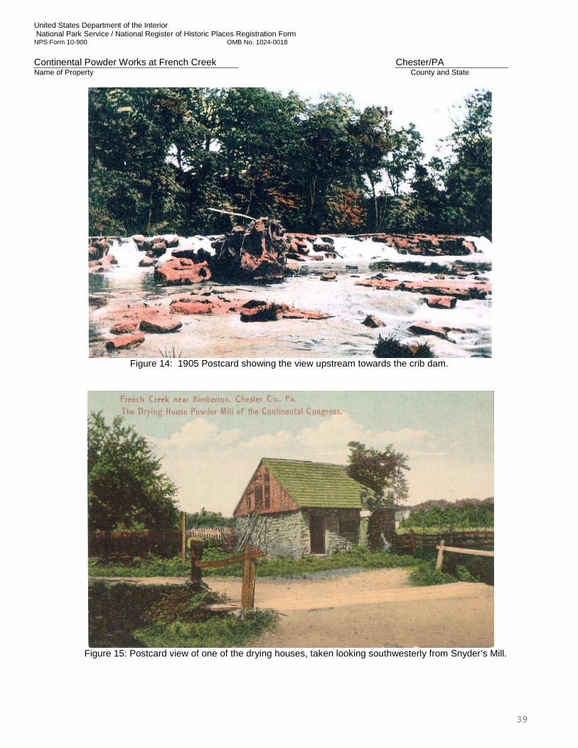
United States Department of the Interior National Park Service / National Register of Historic Places Registration Form NPS Form 10-900 OMB No. 1024-0018 Continental Powder Works at French Creek Chester/PA Name of Property County and State
39
Figure 14: 1905 Postcard showing the view upstream towards the crib dam.
Figure 15: Postcard view of one of the drying houses, taken looking southwesterly from Snyder’s Mill.
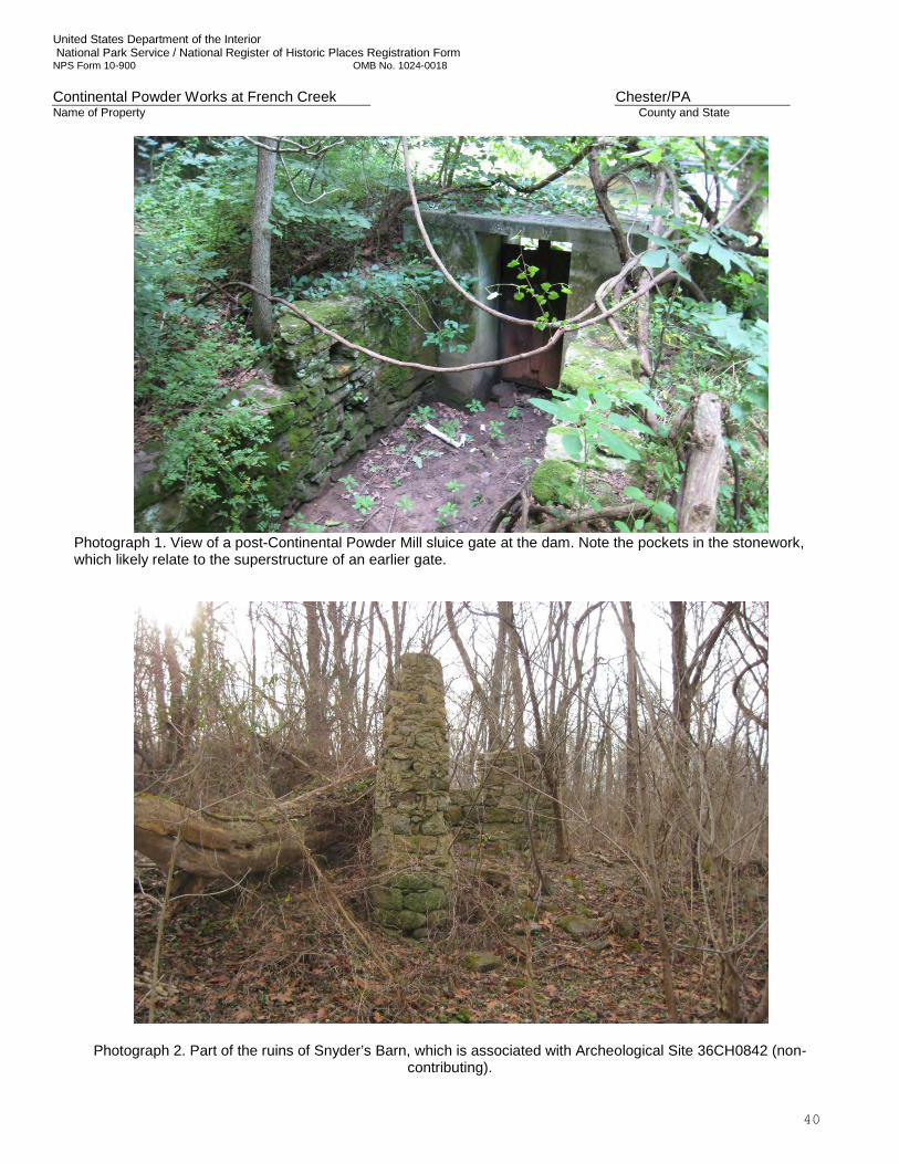
United States Department of the Interior National Park Service / National Register of Historic Places Registration Form NPS Form 10-900 OMB No. 1024-0018 Continental Powder Works at French Creek Chester/PA Name of Property County and State
40
Photograph 1. View of a post-Continental Powder Mill sluice gate at the dam. Note the pockets in the stonework, which likely relate to the superstructure of an earlier gate.
Photograph 2. Part of the ruins of Snyder’s Barn, which is associated with Archeological Site 36CH0842 (non-contributing).
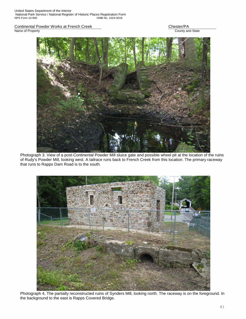
United States Department of the Interior National Park Service / National Register of Historic Places Registration Form NPS Form 10-900 OMB No. 1024-0018 Continental Powder Works at French Creek Chester/PA Name of Property County and State
41
Photograph 3. View of a post-Continental Powder Mill sluice gate and possible wheel pit at the location of the ruins of Rudy’s Powder Mill, looking west. A tailrace runs back to French Creek from this location. The primary raceway that runs to Rapps Dam Road is to the south.
Photograph 4, The partially reconstructed ruins of Synders Mill, looking north. The raceway is on the foreground. In the background to the east is Rapps Covered Bridge.
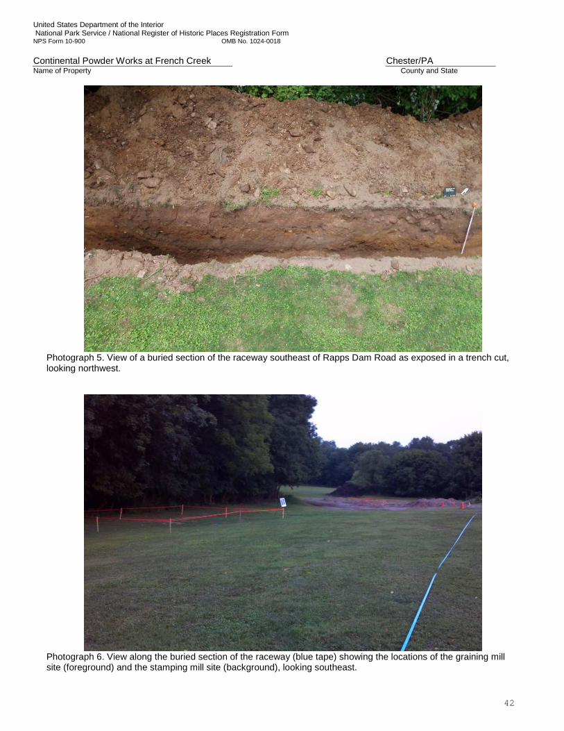
United States Department of the Interior National Park Service / National Register of Historic Places Registration Form NPS Form 10-900 OMB No. 1024-0018 Continental Powder Works at French Creek Chester/PA Name of Property County and State
42
Photograph 5. View of a buried section of the raceway southeast of Rapps Dam Road as exposed in a trench cut, looking northwest.
Photograph 6. View along the buried section of the raceway (blue tape) showing the locations of the graining mill site (foreground) and the stamping mill site (background), looking southeast.
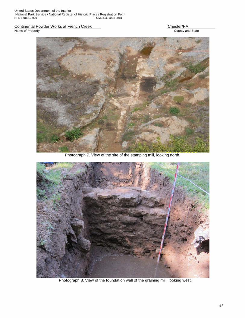
United States Department of the Interior National Park Service / National Register of Historic Places Registration Form NPS Form 10-900 OMB No. 1024-0018 Continental Powder Works at French Creek Chester/PA Name of Property County and State
43
Photograph 7. View of the site of the stamping mill, looking north.
Photograph 8. View of the foundation wall of the graining mill, looking west.
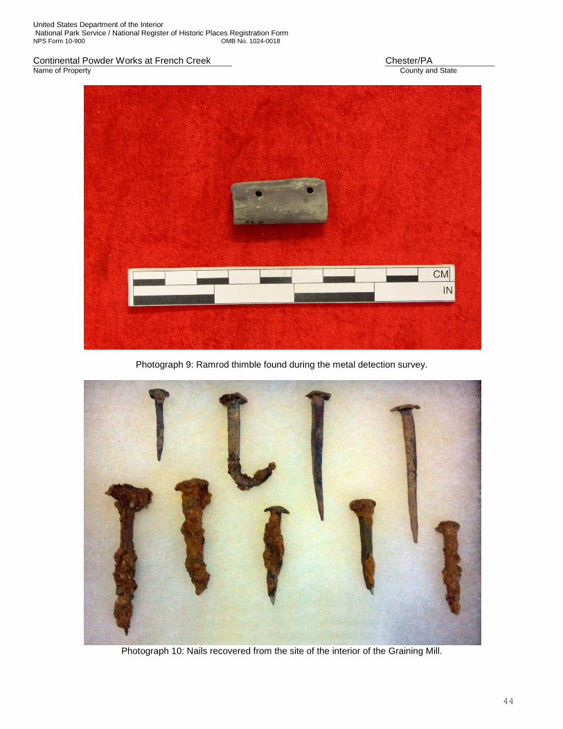
United States Department of the Interior National Park Service / National Register of Historic Places Registration Form NPS Form 10-900 OMB No. 1024-0018 Continental Powder Works at French Creek Chester/PA Name of Property County and State
44
Photograph 9: Ramrod thimble found during the metal detection survey.
Photograph 10: Nails recovered from the site of the interior of the Graining Mill.
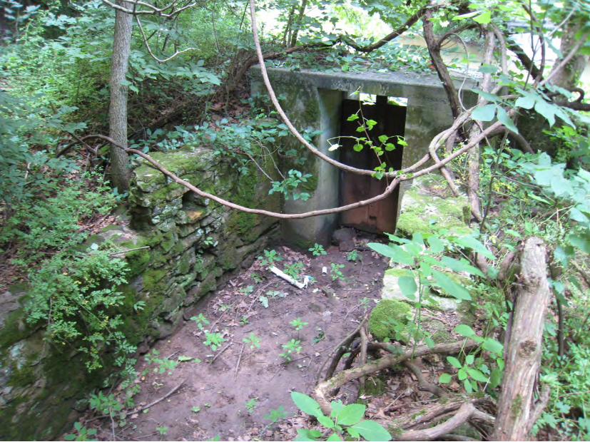
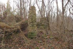
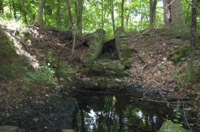
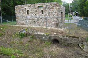
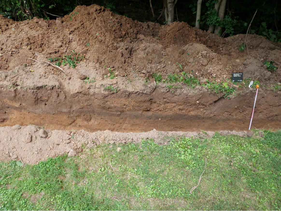
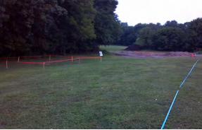
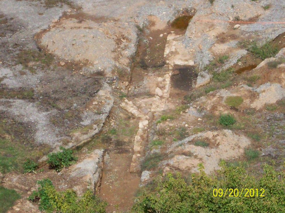
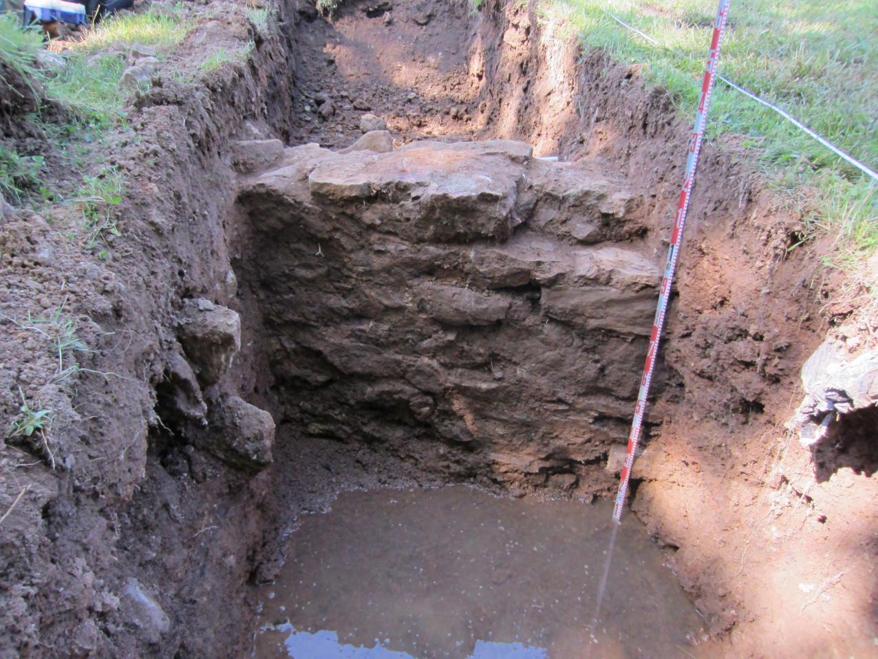
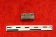
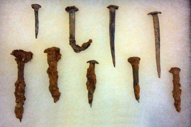


![Vibration Mill - pdfs.semanticscholar.org · cylinder and diamond powder to refines the diamond powder into smaller particles [2]. Vibration mill is a device using the principle of](https://img.pdfslide.us/doc/110x75/5e156b0f2a3f3c6e3c58bd98/vibration-mill-pdfs-cylinder-and-diamond-powder-to-refines-the-diamond-powder.jpg)