Embed Size (px)
Citation preview
Contextualizing Historical Places in a Gazetteer byUsing Historical Maps and Linked Data
Esko Ikkala, Jouni Tuominen, and Eero Hyvonen
Semantic Computing Research Group (SeCo), Aalto Universityhttp://www.seco.tkk.fi/, [email protected]
Abstract. Understanding historical places involves more information than justa place name: the spatiotemporal and cultural context is needed, too. This paperintroduces a solution to the problem of providing historical place names withcontext in a user interface, by using an ontology service that serves historicalplace names on modern and historical maps, with additional contextual linkeddata attached. The solution is being implemented in the use case of creating andmanaging a national level gazetteer and map service HIPLA, hosting over 800000 historical and contemporary places in Finland.
1 Introduction
Historical geographic data [4] is important for many organizations, such as museums, li-braries, archives and media companies. Historians and cultural heritage (CH) researchersoften need to deal with historical place names that change in time. When a catalogeror a historian studying old materials comes across a historical place name, it is a chal-lenge to understand the spatial and temporal dimensions of the place at stake. Historicalplace names can often be seen only on historical maps, and historical geographic datais scattered across multiple sources that can be incomplete and/or mutually conflicting.In order to make a reference to a historical place, while preserving data interoperabilityacross all CH data, there is a need to be able to quickly find out if the place concept forthe place at stake can be found in some of the existing place repositories. Additionally,if the correct place concept is nowhere to be found—a situation quite common with his-torical places—there should be a mechanism to suggest and share new place conceptsamong the CH community.
To tackle these challenges, we have developed a prototype called Finnish Ontol-ogy Service of Historical Places (HIPLA). Using Linked Data technologies, HIPLAprovides a common search interface to historical geographic data like place names,coordinates and historical maps. Contextual information, e.g. historical events or pho-tographs related to a geographic location, is provided to help the user to gain a deeperunderstanding of the historical place. HIPLA also serves as a sustainable and evolvingrepository of historical places by implementing Dynamic Ontology Services for Evolv-ing Ontologies [3]. Cultural Heritage organizations can connect their legacy catalogingsystems to HIPLA using a widget or an API in the same vain as in ONKI [5].
This paper first presents main features of HIPLA from an end-user interface view-point (section 2), complementing the crowdsourcing view to the system [3]. After this
the system architecture is outlined (section 3), and finally lessons leaned thus far in theproject are discussed (section 4). The prototype is available at
http://dev.hipla.fi.
2 Finding and Understanding Historical Places in Context
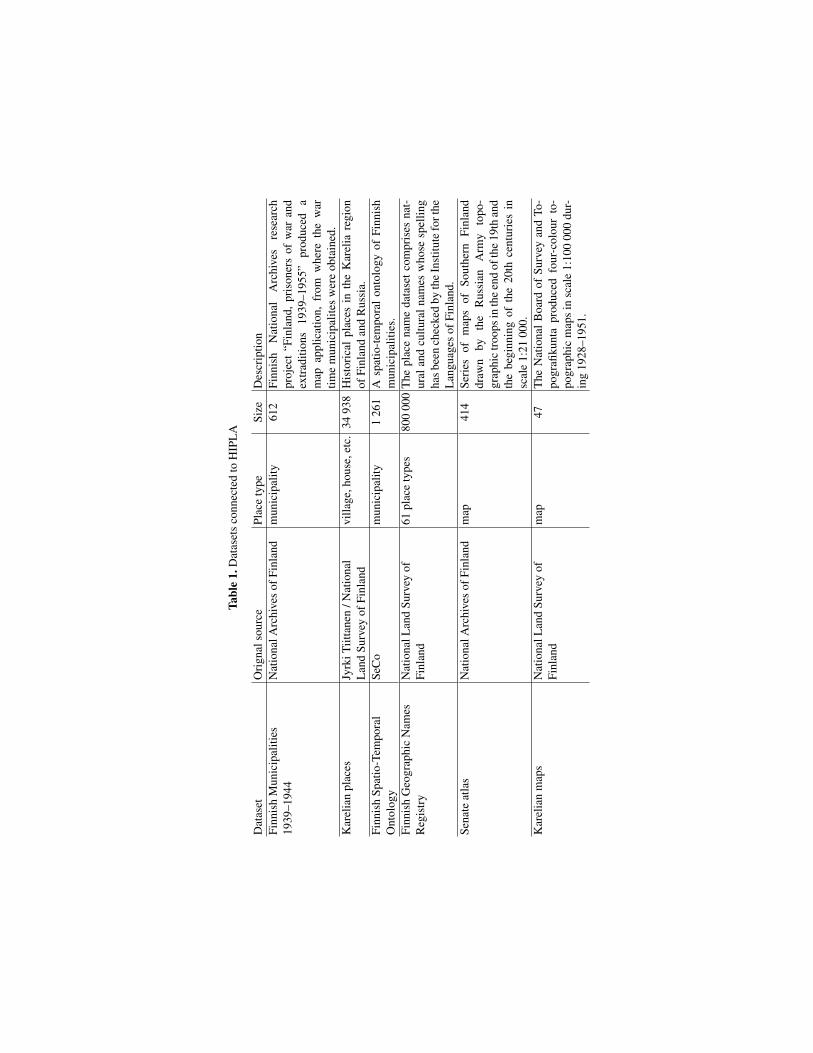
Federated search Our first focus in developing HIPLA has been on modeling, storingand searching Finnish place names in multiple SPARQL endpoints, and on display-ing them on historical and contemporary maps at the same time. The datasets used inHIPLA are stored in separate RDF graphs, which makes it possible to offer dynamic se-lection of data sources for the user interface or external data consumers. Table 1 presentsthe datasets currently connected to HIPLA, available on the Linked Data Finland plat-form1 [2].
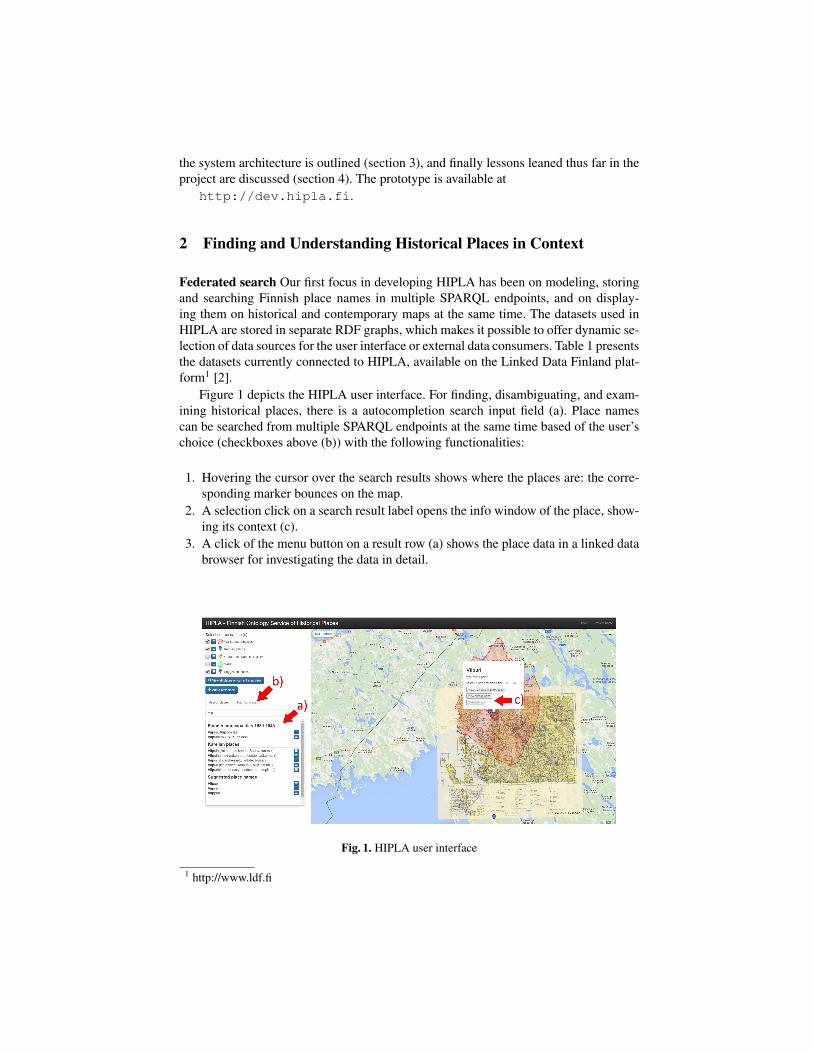
Figure 1 depicts the HIPLA user interface. For finding, disambiguating, and exam-ining historical places, there is a autocompletion search input field (a). Place namescan be searched from multiple SPARQL endpoints at the same time based of the user’schoice (checkboxes above (b)) with the following functionalities:
1. Hovering the cursor over the search results shows where the places are: the corre-sponding marker bounces on the map.
2. A selection click on a search result label opens the info window of the place, show-ing its context (c).
3. A click of the menu button on a result row (a) shows the place data in a linked databrowser for investigating the data in detail.
Fig. 1. HIPLA user interface
1 http://www.ldf.fi
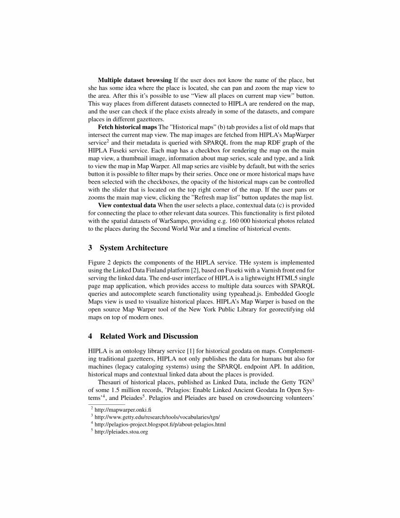
Multiple dataset browsing If the user does not know the name of the place, butshe has some idea where the place is located, she can pan and zoom the map view tothe area. After this it’s possible to use “View all places on current map view” button.This way places from different datasets connected to HIPLA are rendered on the map,and the user can check if the place exists already in some of the datasets, and compareplaces in different gazetteers.
Fetch historical maps The ”Historical maps” (b) tab provides a list of old maps thatintersect the current map view. The map images are fetched from HIPLA’s MapWarperservice2 and their metadata is queried with SPARQL from the map RDF graph of theHIPLA Fuseki service. Each map has a checkbox for rendering the map on the mainmap view, a thumbnail image, information about map series, scale and type, and a linkto view the map in Map Warper. All map series are visible by default, but with the seriesbutton it is possible to filter maps by their series. Once one or more historical maps havebeen selected with the checkboxes, the opacity of the historical maps can be controlledwith the slider that is located on the top right corner of the map. If the user pans orzooms the main map view, clicking the ”Refresh map list” button updates the map list.
View contextual data When the user selects a place, contextual data (c) is providedfor connecting the place to other relevant data sources. This functionality is first pilotedwith the spatial datasets of WarSampo, providing e.g. 160 000 historical photos relatedto the places during the Second World War and a timeline of historical events.
3 System Architecture
Figure 2 depicts the components of the HIPLA service. THe system is implementedusing the Linked Data Finland platform [2], based on Fuseki with a Varnish front end forserving the linked data. The end-user interface of HIPLA is a lightweight HTML5 singlepage map application, which provides access to multiple data sources with SPARQLqueries and autocomplete search functionality using typeahead.js. Embedded GoogleMaps view is used to visualize historical places. HIPLA’s Map Warper is based on theopen source Map Warper tool of the New York Public Library for georectifying oldmaps on top of modern ones.
4 Related Work and Discussion
HIPLA is an ontology library service [1] for historical geodata on maps. Complement-ing traditional gazetteers, HIPLA not only publishes the data for humans but also formachines (legacy cataloging systems) using the SPARQL endpoint API. In addition,historical maps and contextual linked data about the places is provided.
Thesauri of historical places, published as Linked Data, include the Getty TGN3
of some 1.5 million records, ’Pelagios: Enable Linked Ancient Geodata In Open Sys-tems’4, and Pleiades5. Pelagios and Pleiades are based on crowdsourcing volunteers’
2 http://mapwarper.onki.fi3 http://www.getty.edu/research/tools/vocabularies/tgn/4 http://pelagios-project.blogspot.fi/p/about-pelagios.html5 http://pleiades.stoa.org
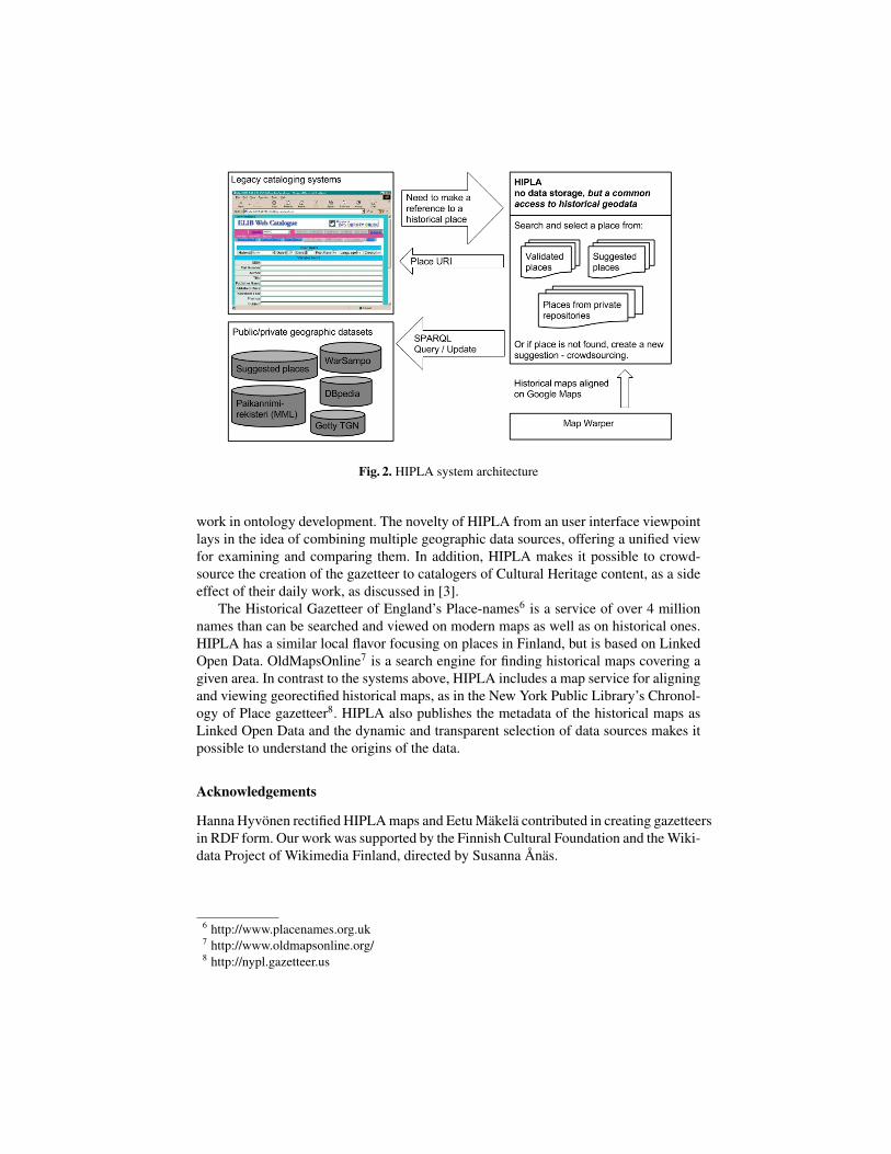
Fig. 2. HIPLA system architecture
work in ontology development. The novelty of HIPLA from an user interface viewpointlays in the idea of combining multiple geographic data sources, offering a unified viewfor examining and comparing them. In addition, HIPLA makes it possible to crowd-source the creation of the gazetteer to catalogers of Cultural Heritage content, as a sideeffect of their daily work, as discussed in [3].
The Historical Gazetteer of England’s Place-names6 is a service of over 4 millionnames than can be searched and viewed on modern maps as well as on historical ones.HIPLA has a similar local flavor focusing on places in Finland, but is based on LinkedOpen Data. OldMapsOnline7 is a search engine for finding historical maps covering agiven area. In contrast to the systems above, HIPLA includes a map service for aligningand viewing georectified historical maps, as in the New York Public Library’s Chronol-ogy of Place gazetteer8. HIPLA also publishes the metadata of the historical maps asLinked Open Data and the dynamic and transparent selection of data sources makes itpossible to understand the origins of the data.
Acknowledgements
Hanna Hyvonen rectified HIPLA maps and Eetu Makela contributed in creating gazetteersin RDF form. Our work was supported by the Finnish Cultural Foundation and the Wiki-data Project of Wikimedia Finland, directed by Susanna Anas.
6 http://www.placenames.org.uk7 http://www.oldmapsonline.org/8 http://nypl.gazetteer.us
Tabl
e1.
Dat
aset
sco
nnec
ted
toH
IPL
A
Dat
aset
Ori
gnal
sour
cePl
ace
type
Size
Des
crip
tion
Finn
ish
Mun
icip
aliti
es19
39–1
944
Nat
iona
lArc
hive
sof
Finl
and
mun
icip
ality
612
Finn
ish
Nat
iona
lA
rchi
ves
rese
arch
proj
ect
“Fin
land
,pr
ison
ers
ofw
aran
dex
trad
ition
s19
39–1
955”
prod
uced
am
apap
plic
atio
n,fr
omw
here
the
war
time
mun
icip
alite
sw
ere
obta
ined
.K
arel
ian
plac
esJy
rkiT
iitta
nen
/Nat
iona
lL
and
Surv
eyof
Finl
and
villa
ge,h
ouse
,etc
.34
938
His
tori
cal
plac
esin
the
Kar
elia
regi
onof
Finl
and
and
Rus
sia.
Finn
ish
Spat
io-T
empo
ral
Ont
olog
ySe
Co
mun
icip
ality
126
1A
spat
io-t
empo
ral
onto
logy
ofFi
nnis
hm
unic
ipal
ities
.Fi
nnis
hG
eogr
aphi
cN
ames
Reg
istr
yN
atio
nalL
and
Surv
eyof
Finl
and
61pl
ace
type
s80
000
0T
hepl
ace
nam
eda
tase
tcom
pris
esna
t-ur
alan
dcu
ltura
lnam
esw
hose
spel
ling
hasb
een
chec
ked
byth
eIn
stitu
tefo
rthe
Lan
guag
esof
Finl
and.
Sena
teat
las
Nat
iona
lArc
hive
sof
Finl
and
map
414
Seri
esof
map
sof
Sout
hern
Finl
and
draw
nby
the
Rus
sian
Arm
yto
po-
grap
hic
troo
psin
the
end
ofth
e19
than
dth
ebe
ginn
ing
ofth
e20
thce
ntur
ies
insc
ale
1:21
000.
Kar
elia
nm
aps
Nat
iona
lLan
dSu
rvey
ofFi
nlan
dm
ap47
The
Nat
iona
lBoa
rdof
Surv
eyan
dTo
-po
grafi
kunt
apr
oduc
edfo
ur-c
olou
rto
-po
grap
hic
map
sin
scal
e1:
100
000
dur-
ing
1928
–195
1.
References
1. d’Aquin, M., Noy, N.F.: Where to publish and find ontologies? A survey of ontology libraries.Web Semantics: Science, Services and Agents on the World Wide Web 11, 96–111 (2012)
2. Hyvonen, E., Tuominen, J., Alonen, M., Makela, E.: Linked data finland: A 7-star model andplatform for publishing and re-using linked datasets. In: The Semantic Web: ESWC 2014Satellite Events, Revised Selected Papers. pp. 226–230. Springer–Verlag (2014)
3. Hyvonen, E., Tuominen, J., Ikkala, E., Makela, E.: Ontology services based on crowdsourcing:Case national gazetteer of historical places. In: Proceedings of 14th International SemanticWeb Conference (ISWC 2015), Posters and Demos (2015)
4. Southall, H., Mostern, R., Berman, M.L.: On historical gazetteers. International Journal ofHumanities and Arts Computing 5, 127–145 (2011)
5. Tuominen, J., Frosterus, M., Viljanen, K., Hyvonen, E.: ONKI SKOS server for publishing andutilizing SKOS vocabularies and ontologies as services. In: Proceedings of the 6th EuropeanSemantic Web Conference (ESWC 2009). pp. 768–780. Springer–Verlag (2009)