Embed Size (px)
Citation preview
ENVIRONMENTAL IMPACT ASSESSMENT FOR THE RUMICHACA - PASTO DIVIDED HIGHWAY PROJECT, SAN JUAN
- PEDREGAL SEGMENT, CONCESSION AGREEMENT UNDER PPP SCHEME No. 15 OF 2015
GEO-002-17-114-EAM Version 0. May 2017
CSH-1-AM-AM-EIA-0001-0
3. PROJECT DESCRIPTION
CONTENTS
CONTENTS
Page
3 PROJECT DESCRIPTION __________________________________________________________ 1
3.1 LOCATION_____________________________________________________________________ 1
3.2 PROJECT CHARACTERISTICS_______________________________________________________ 3
3.2.1 Existing infrastructure. __________________________________________________________ 6
3.2.1.1 Types of road. _________________________________________________________________ 6
3.2.1.2 Road infrastructure. ____________________________________________________________ 6
3.2.1.2.1 Road INVIAS code 2501 – Rumichaca International Bridge – San Juan de Pasto. _____________ 6
3.2.1.2.2 Access road to the municipal center of Iles. _________________________________________ 12
3.2.1.2.3 San Juan – Contadero road. _____________________________________________________ 15
3.2.1.2.4 Contadero – Aldea de María – Iles road. ___________________________________________ 18
3.2.1.2.5 Ospina Pérez – Iles road. ________________________________________________________ 22
3.2.1.2.6 Urbano road – KP29+508 on the Rumichaca – Pasto road. _____________________________ 25
3.2.1.2.7 Iles – Pilcuán Viejo road. ________________________________________________________ 27
3.2.1.2.8 Pilcuán Viejo – Arco Iris Condominium road. ________________________________________ 29
3.2.1.2.9 Arco Iris Condominium internal road.______________________________________________ 31
3.2.1.2.10 Pilcuán Viejo – La Rejoya road. ___________________________________________________ 33
3.2.1.2.11 Contadero – San Francisco road. _________________________________________________ 35
3.2.1.2.12 El Capulí access road. ___________________________________________________________ 38
3.2.1.2.13 Ospina Pérez access road. _______________________________________________________ 40
3.2.1.2.14 San Juan – ZODME Z1-12 road. ___________________________________________________ 41
3.2.1.2.15 San Juan – Loma de Suras village road. ____________________________________________ 43
3.2.1.2.16 Access road to El Tesoro farm. ___________________________________________________ 44
3.2.1.2.17 Access road to El Porvenir farm. __________________________________________________ 46
3.2.1.3 Railway lines. _________________________________________________________________ 48
3.2.1.4 Utilities networks and assets. ____________________________________________________ 48
3.2.1.5 Urban, architectural, cultural or archaeological heritage. ______________________________ 49
3.2.1.6 Protected areas. _______________________________________________________________ 50
3.2.1.7 Ethnic communities. ___________________________________________________________ 51
ENVIRONMENTAL IMPACT ASSESSMENT FOR THE RUMICHACA - PASTO DIVIDED HIGHWAY PROJECT, SAN JUAN
- PEDREGAL SEGMENT, CONCESSION AGREEMENT UNDER PPP SCHEME No. 15 OF 2015
GEO-002-17-114-EAM Version 0. May 2017
CSH-1-AM-AM-EIA-0001-0
3. PROJECT DESCRIPTION
CONTENTS
3.2.1.8 Mineral rights. ________________________________________________________________ 51
3.2.2 Project phases and activities. ____________________________________________________ 52
3.2.3 Project design. ________________________________________________________________ 54
3.2.3.1 Layout and geometric characteristics of the roads to be built as part of the project. ________ 54
3.2.3.1.1 Classification of the highway. ____________________________________________________ 54
3.2.3.1.2 Components. _________________________________________________________________ 55
3.2.3.1.3 Project transportation infrastructure. _____________________________________________ 64
3.2.3.1.4 Drainage infrastructure. _______________________________________________________ 106
3.2.3.1.5 Geotechnical infrastructure. ____________________________________________________ 124
3.2.3.1.6 Energy supply infrastructure. ___________________________________________________ 138
3.2.3.2 Infrastructure associated with the project. ________________________________________ 138
3.2.3.2.1 Temporary camps. ____________________________________________________________ 138
3.2.3.2.2 Material sources. _____________________________________________________________ 145
3.2.3.2.3 Process plants. _______________________________________________________________ 145
3.2.3.3 Infrastructure and services affected by the project. _________________________________ 145
3.2.3.3.1 Utilities.__ __________________________________________________________________ 145
3.2.3.3.2 Other ____________________________________________________________________ 157
3.2.4 Project supplies. ______________________________________________________________ 158
3.2.4.1 Construction materials. ________________________________________________________ 158
3.2.4.2 Other ______________________________________________________________________ 159
3.2.4.2.1 Fuels, oils, greases and solvents._________________________________________________ 159
3.2.4.2.2 Processed supplies. ___________________________________________________________ 159
3.2.4.2.3 Explosives. __________________________________________________________________ 160
3.2.4.2.4 Other supplies. _______________________________________________________________ 162
3.2.4.3 Leftover material. ____________________________________________________________ 164
3.2.5 Management and disposal of leftover excavation, construction and demolition material. ___ 165
3.2.5.1 List of estimated volumes for disposal. ___________________________________________ 165
3.2.5.2 Location of potential sites for ZODME placement. __________________________________ 167
3.2.5.3 ZODME design._______________________________________________________________ 169
3.2.5.3.1 Analysis of safety factors and displacement risk. ____________________________________ 169
3.2.5.3.2 Identification of dwellings and water bodies. ______________________________________ 170
ENVIRONMENTAL IMPACT ASSESSMENT FOR THE RUMICHACA - PASTO DIVIDED HIGHWAY PROJECT, SAN JUAN
- PEDREGAL SEGMENT, CONCESSION AGREEMENT UNDER PPP SCHEME No. 15 OF 2015
GEO-002-17-114-EAM Version 0. May 2017
CSH-1-AM-AM-EIA-0001-0
3. PROJECT DESCRIPTION
CONTENTS
3.2.5.3.3 Design parameters. ___________________________________________________________ 170 3.2.5.3.4 Plan view and cross sections for final structure. ____________________________________ 173
3.2.5.3.5 Identification of end uses. ______________________________________________________ 173
3.2.6 Hazardous and non-hazardous waste. ____________________________________________ 173
3.2.6.1 Classification of solid waste. ____________________________________________________ 174
3.2.6.1.1 Domestic waste. _____________________________________________________________ 174
3.2.6.1.2 Industrial waste. _____________________________________________________________ 174
3.2.6.1.3 Overburden.__ _______________________________________________________________ 175
3.2.6.2 Projected volumes of solid waste. _______________________________________________ 175
3.2.6.2.1 Domestic solid waste _____________________________________ Error! Bookmark not defined.
3.2.6.2.2 Industrial solid waste _____________________________________ Error! Bookmark not defined.
3.2.6.3 Foreseeable environmental impacts. _____________________________________________ 176
3.2.6.4 Management and disposal. _____________________________________________________ 177
3.2.6.4.1 Identification and classification of waste. _________________________________________ 177
3.2.6.4.2 Temporary storage of waste. ___________________________________________________ 179
3.2.6.4.3 Collection and transport. _______________________________________________________ 179
3.2.6.4.4 Final disposal ___________________________________________ Error! Bookmark not defined.
3.2.7 Project costs. ________________________________________________________________ 180
3.2.8 Project schedule. _____________________________________________________________ 180
3.2.9 Project organization. __________________________________________________________ 183
ENVIRONMENTAL IMPACT ASSESSMENT FOR THE RUMICHACA - PASTO DIVIDED HIGHWAY PROJECT, SAN JUAN
- PEDREGAL SEGMENT, CONCESSION AGREEMENT UNDER PPP SCHEME No. 15 OF 2015
GEO-002-17-114-EAM Version 0. May 2017
CSH-1-AM-AM-EIA-0001-0
3. PROJECT DESCRIPTION
CONTENTS
INDEX OF TABLES
Page
Table 3.1 Location of the project. ________________________________________________________ 1
Table 3.2 Types of road according to INVIAS, as per functionality _______________________________ 6
Table 3.3 Works that it will be possible to access through the Rumichaca – Pasto road. ____________ 12
Table 3.4 Works that it will be possible to enter through the Iles access road. ____________________ 15
Table 3.5 Works that it will be possible to access through the San Juan – Contadero road. _________ 18
Table 3.6 Works that it will be possible to access through the Contadero – Iles road. ______________ 21
Table 3.7 Works that it will be possible to access through the Ospina Pérez – Iles road. ____________ 25
Table 3.8 Works that it will be possible to access through the Iles – Pilcuán Viejo road. ____________ 29
Table 3.9 Works that it will be possible to access through the Arco Iris Condominium’s internal road. 33
Table 3.10 Works that it will be possible to access through the Pilcuán Viejo – La Rejoya road. _______ 35
Table 3.11 Works that it will be possible to enter through the Contadero – San Francisco road. ______ 38
Table 3.12 Works that it will be possible to enter through the El Capulí access road. _______________ 40
Table 3.13 Works that it will be possible to enter through the San Juan – ZODME Z1-12 road. ________ 43
Table 3.14 Works that it will be possible to enter through the San Juan – Loma de Suras village road. _ 44
Table 3.15 Works that it will be possible to enter through the El Tesoro farm access road. __________ 46
Table 3.16 Works that it will be possible to enter through the El Porvenir farm access road. _________ 48
Table 3.17 Identification of network operators and description. ________________________________ 49
Table 3.18 Mineral rights for material sources nearby the project. ______________________________ 51
Table 3.19 Project phases and activities. ___________________________________________________ 52
Table 3.20 Characteristics by excavation slope sections. ______________________________________ 58
Table 3.21 Characteristics by fill slope sections. _____________________________________________ 60
Table 3.22 Project design parameters. ____________________________________________________ 65
Table 3.23 Design parameters for interchanges and connections. _______________________________ 65
Table 3.24 Design parameters for turnarounds. _____________________________________________ 66
Table 3.25 List of existing roads crossed. ___________________________________________________ 92
Table 3.26 Characteristics of Service Area KP28+800. _______________________________________ 106
Table 3.27 Transverse works to be built in the San Juan Pedregal Segment. ______________________ 107
Table 3.28 Planned water energy dissipaters (at entry) in the form of stepped chutes. _____________ 114
Table 3.29 Planned water energy dissipaters (at exit) in the form of stepped chutes. ______________ 116
ENVIRONMENTAL IMPACT ASSESSMENT FOR THE RUMICHACA - PASTO DIVIDED HIGHWAY PROJECT, SAN JUAN
- PEDREGAL SEGMENT, CONCESSION AGREEMENT UNDER PPP SCHEME No. 15 OF 2015
GEO-002-17-114-EAM Version 0. May 2017
CSH-1-AM-AM-EIA-0001-0
3. PROJECT DESCRIPTION
CONTENTS
Table 3.30 Projected channeling. ________________________________________________________ 117
Table 3.31 Surface water channel crossing sites. ___________________________________________ 123
Table 3.32 Sectioning of geotechnical works in cut areas. ____________________________________ 133
Table 3.33 Sectioning of geotechnical works in fill areas. _____________________________________ 135
Table 3.34 San Juan Camp facilities KP18+800. _____________________________________________ 138
Table 3.35 Iles Camp facilities KP31+000. _________________________________________________ 139
Table 3.36 Iles Camp facilities KP35+600. _________________________________________________ 140
Table 3.37 Mikel Camp facilities KP41+300. _______________________________________________ 141
Table 3.38 Location of process plants. ____________________________________________________ 145
Table 3.39 List of water supply networks. _________________________________________________ 146
Table 3.40 List of sewage networks. _____________________________________________________ 146
Table 3.41 List of low voltage electricity networks. _________________________________________ 148
Table 3.42 List of medium voltage electricity networks. ______________________________________ 152
Table 3.43 List of high voltage electricity networks. _________________________________________ 156
Table 3.44 List of public street lighting electricity networks. __________________________________ 156
Table 3.45 List of information and communication technology networks. _______________________ 156
Table 3.46 Project intersection with irrigation district. _______________________________________ 158
Table 3.47 Stone supplies ______________________________________________________________ 158
Table 3.48 Supplies derived from fuels, oils, greases and solvents. _____________________________ 159
Table 3.49 Processed supplies for the project. _____________________________________________ 159
Table 3.50 Explosives supplies for blasting. ________________________________________________ 160
Table 3.51 Number of blasts by quantity of material. ________________________________________ 160
Table 3.52 Total supplies. ______________________________________________________________ 160
Table 3.53 Blasting specifications. _______________________________________________________ 161
Table 3.54 Estimated vibrations. ________________________________________________________ 162
Table 3.55 Estimated amounts for other supplies. __________________________________________ 163
Table 3.56 Volume of earthworks. _______________________________________________________ 165
Table 3.57 Usable volume for the ZODME. ________________________________________________ 165
Table 3.58 Usable volume for non-structural fills. ___________________________________________ 167
Table 3.59 Location of the ZODME. ______________________________________________________ 167
Table 3.60 Location of non-structural fills. ________________________________________________ 168
ENVIRONMENTAL IMPACT ASSESSMENT FOR THE RUMICHACA - PASTO DIVIDED HIGHWAY PROJECT, SAN JUAN
- PEDREGAL SEGMENT, CONCESSION AGREEMENT UNDER PPP SCHEME No. 15 OF 2015
GEO-002-17-114-EAM Version 0. May 2017
CSH-1-AM-AM-EIA-0001-0
3. PROJECT DESCRIPTION
CONTENTS
Table 3.61 Geotechnical units in the assessment area. ______________________________________ 169
Table 3.62 Studies carried out in each ZODME and/or non-structural fill. ___ Error! Bookmark not defined.
Table 3.63 Design parameters for the ZODME. _____________________________________________ 170
Table 3.64 Design parameters for non-structural fills. _______________________________________ 171
Table 3.65 Classification and description of types of solid waste. ______________________________ 174
Table 3.66 Management of industrial solid waste. __________________________________________ 174
Table 3.67 Personnel who will work on different stages of the project. _________________________ 176
Table 3.68 Industrial solid waste. ________________________________________________________ 176
Table 3.69 Impacts identified relating to solid waste. ________________________________________ 176
Table 3.70 Classification of ordinary solid waste. ___________________________________________ 178
INDEX OF FIGURES
Page
Figure 3.1 Location of the Rumichaca – Pasto Divided highway Project, San Juan - Pedregal segment. __ 3
Figure 3.2 Typical cross-section of the divided highway, with median strip. _______________________ 4
Figure 3.3 Roadways separated by the Pilcuán bypass. ________________________________________ 5
Figure 3.4 Typical cross-section for the divided highway, with separated roadways. ________________ 5
Figure 3.5 Layout of road INVIAS code 2501 – Rumichaca International Bridge – San Juan de Pasto. ___ 7
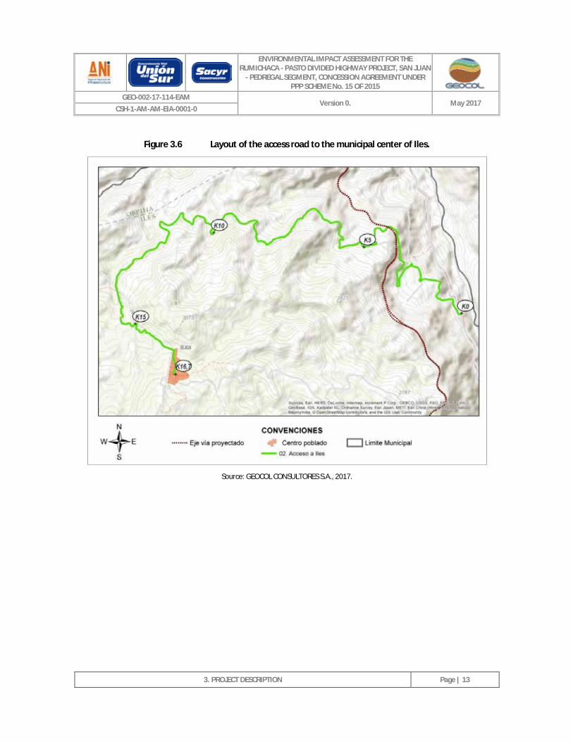
Figure 3.6 Layout of the access road to the municipal center of Iles. ____________________________ 13
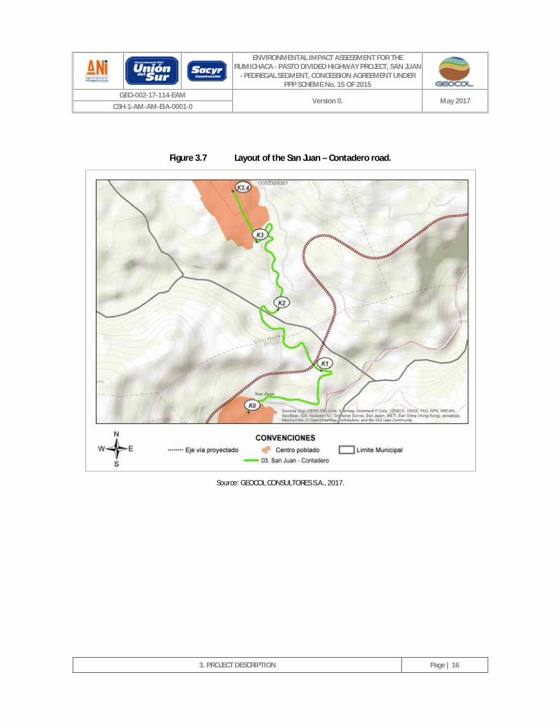
Figure 3.7 Layout of the San Juan – Contadero road. _________________________________________ 16
Figure 3.8 Layout of the Contadero – Iles road. _____________________________________________ 19
Figure 3.9 Layout of the Ospina Pérez – Iles road. ___________________________________________ 22
Figure 3.10 Layout of the Urbano road - KP29+508 on the Rumichaca – Pasto road. ________________ 26
Figure 3.11 Layout of the Iles – Pilcuán Viejo road. ___________________________________________ 28
Figure 3.12 Layout of the Pilcuán Viejo – Arco Iris Condominium road. ___________________________ 30
Figure 3.13 Layout of the Arco Iris Condominium internal road. _________________________________ 32
Figure 3.14 Layout of the Pilcuán Viejo – La Rejoya road. ______________________________________ 34
Figure 3.15 Layout of the Contadero – San Francisco road. _____________________________________ 36
Figure 3.16 Layout of the El Capulí access road. ______________________________________________ 39
Figure 3.17 Layout of the Ospina Pérez access road. __________________________________________ 40
Figure 3.18 Layout of the San Juan – ZODME Z1-12 road. ______________________________________ 42
ENVIRONMENTAL IMPACT ASSESSMENT FOR THE RUMICHACA - PASTO DIVIDED HIGHWAY PROJECT, SAN JUAN
- PEDREGAL SEGMENT, CONCESSION AGREEMENT UNDER PPP SCHEME No. 15 OF 2015
GEO-002-17-114-EAM Version 0. May 2017
CSH-1-AM-AM-EIA-0001-0
3. PROJECT DESCRIPTION
CONTENTS
Figure 3.19 Layout of the San Juan – Loma de Suras village road. ________________________________ 43
Figure 3.20 Layout of the El Tesoro farm access road. _________________________________________ 45
Figure 3.21 Layout of the El Porvenir farm access road. _______________________________________ 47
Figure 3.22 Location of Section 8 of Qhapaq Ñam. ___________________________________________ 50
Figure 3.23 Divided highway section – parallel roadways. ______________________________________ 55
Figure 3.24 Road width –separated roadways. _______________________________________________ 55
Figure 3.25 Roadways separated by the Pilcuán bypass. _______________________________________ 56
Figure 3.26 Sidewalks in road access areas. _________________________________________________ 63
Figure 3.27 Typical median strip in a road section with parallel roadways. ________________________ 64
Figure 3.28 Typical cross section of the Boquerón Bridge. ______________________________________ 67
Figure 3.29 Plan view of the Boquerón Bridge. _______________________________________________ 68
Figure 3.30 Boquerón Bridge Elevation. ____________________________________________________ 68
Figure 3.31 General configuration of the substructure for support 2 Boquerón Bridge. ______________ 69
Figure 3.32 General configuration of the substructure for support 3 Boquerón Bridge. ______________ 70
Figure 3.33 General configuration of the substructure for support 4 Boquerón Bridge. ______________ 71
Figure 3.34 Elevation and plan view of the supporting foundation for pier three (3) of the Boquerón Bridge. _____________________________________________________________________ 72
Figure 3.35 Abutment geometry for roadway 1 of the Boquerón Bridge. __________________________ 73
Figure 3.36 Plan view of the El Tablón Alto Bridge. ___________________________________________ 73
Figure 3.37 Elevation of the El Tablón Alto Bridge.____________________________________________ 74
Figure 3.38 Typical cross section of the El Tablón Alto Bridge. __________________________________ 74
Figure 3.39 Cross section, by pier, of the El Tablón Alto Bridge. _________________________________ 75
Figure 3.40 Plan section of the foundations of the El Tablón Alto Bridge. _________________________ 76
Figure 3.41 Plan view of the Macal Stream Bridge. ___________________________________________ 76
Figure 3.42 Elevation of the Macal Stream Bridge. ____________________________________________ 77
Figure 3.43 Typical cross section of the Macal Stream Bridge. __________________________________ 77
Figure 3.44 Plan section of the foundations of the Macal Stream Bridge. _________________________ 78
Figure 3.45 Plan view of the El Porvenir rural district Bridge. ___________________________________ 78
Figure 3.46 Elevation of the El Porvenir rural district Bridge. ___________________________________ 79
Figure 3.47 Typical cross section of the El Porvenir rural district Bridge. __________________________ 79
Figure 3.48 Cross section of piers 2 and 3 of the El Porvenir rural district Bridge. ___________________ 80
ENVIRONMENTAL IMPACT ASSESSMENT FOR THE RUMICHACA - PASTO DIVIDED HIGHWAY PROJECT, SAN JUAN
- PEDREGAL SEGMENT, CONCESSION AGREEMENT UNDER PPP SCHEME No. 15 OF 2015
GEO-002-17-114-EAM Version 0. May 2017
CSH-1-AM-AM-EIA-0001-0
3. PROJECT DESCRIPTION
CONTENTS
Figure 3.49 Foundations of Piers 2 and 3 of the El Porvenir rural district Bridge. ____________________ 81
Figure 3.50 Plan view of the Sapuyes River Bridge. ___________________________________________ 82
Figure 3.51 Elevation of the Sapuyes River Bridge. ___________________________________________ 83
Figure 3.52 Typical cross section of the Sapuyes River Bridge. __________________________________ 83
Figure 3.53 Cross section of pier 1 of the Sapuyes River Bridge. _________________________________ 85
Figure 3.54 Plan section of the foundations of the Sapuyes River Bridge. _________________________ 86
Figure 3.55 Interchange connecting with San Juan - KP17+300. _________________________________ 87
Figure 3.56 Interchange connecting with Contadero – KP18+700. _______________________________ 87
Figure 3.57 Connection to Iles road. _______________________________________________________ 88
Figure 3.58 Interchange for Pilcuán – KP41+700. _____________________________________________ 89
Figure 3.59 Turnaround KP24+050. ________________________________________________________ 90
Figure 3.60 Turnaround KP33+600. ________________________________________________________ 90
Figure 3.61 Turnaround KP38+250. ________________________________________________________ 91
Figure 3.62 Pilcuán bypass. ______________________________________________________________ 91
Figure 3.63 Typical cross section of escape roads. ___________________________________________ 102
Figure 3.64 Typical plan section of escape roads. ____________________________________________ 103
Figure 3.65 Escape road KP21+400. ______________________________________________________ 103
Figure 3.66 Escape road KP22+400. ______________________________________________________ 104
Figure 3.67 Escape road K27+980. ________________________________________________________ 104
Figure 3.68 Escape road KP36+300. ______________________________________________________ 105
Figure 3.69 Escape road KP39+490. ______________________________________________________ 105
Figure 3.70 Plan Section of Service Area KP28+800.__________________________________________ 106
Figure 3.71 Cross section, circular culvert Ø 900 mm. ________________________________________ 112
Figure 3.72 Geometry of a box culvert with a 2.0 x 2.0 m box. _________________________________ 113
Figure 3.73 Cross-section of side gutter. ___________________________________________________ 118
Figure 3.74 Use of existing gutter. ________________________________________________________ 119
Figure 3.75 Cross-section of median strip gutter. ____________________________________________ 119
Figure 3.76 Cross section of berm gutter. __________________________________________________ 120
Figure 3.77 Cross section of channel gutter in access. ________________________________________ 121
Figure 3.78 Cross section - gutter pipe. ___________________________________________________ 121
Figure 3.79 Cross section of side gutter in cuts, and filter. ____________________________________ 122
ENVIRONMENTAL IMPACT ASSESSMENT FOR THE RUMICHACA - PASTO DIVIDED HIGHWAY PROJECT, SAN JUAN
- PEDREGAL SEGMENT, CONCESSION AGREEMENT UNDER PPP SCHEME No. 15 OF 2015
GEO-002-17-114-EAM Version 0. May 2017
CSH-1-AM-AM-EIA-0001-0
3. PROJECT DESCRIPTION
CONTENTS
Figure 3.80 Cross-section of median strip gutter, and filter. ___________________________________ 122
Figure 3.81 Typical cross section of clearing excavation. ______________________________________ 126
Figure 3.82 Detail of typical slope mesh. __________________________________________________ 127
Figure 3.83 Typical cross section, horizontal drains. _________________________________________ 128
Figure 3.84 Typical cross section of adzing in hillside fills _____________________________________ 129
Figure 3.85 Typical cross section of scaling in fills. ___________________________________________ 130
Figure 3.86 Typical cross section of rockfills in fills. __________________________________________ 130
Figure 3.87 6.0 m high concrete wall. _____________________________________________________ 131
Figure 3.88 Typical cross section of green or flexible wall. ____________________________________ 132
Figure 3.89 Geographical location of the OTA - Orito - Tumaco oil pipeline relative to the Road Project 147
Figure 3.90 Location of the ZODME and/or Non-Structural fills. ________________________________ 169
Figure 3.91 Cross section of the perimeter gutter. ___________________________________________ 172
Figure 3.92 Perimeter gutter water energy dissipater (exit). ___________________________________ 172
Figure 3.93 Detail of fishbone filter. ______________________________________________________ 173
Figure 3.94 Riprap cordon. _____________________________________________________________ 173
Figure 3.95 Work plan for the Rumichaca - Pasto Divided Highway Project, San Juan - Pedregal segment. __________________________________________________________________________ 181
Figure 3.96 Organization of the Rumichaca - Pasto Divided Highway Project, San Juan - Pedregal segment __________________________________________________________________________ 184
INDEX OF PHOTOGRAPHS
Page
Photograph 3.1 KP0+000. Rumichaca International Bridge. ______________________________________ 8
Photograph 3.2 KP0+823. Intersection that allows access to the Ipiales bypass. ______________________ 8
Photograph 3.3 KP8+197. Flexible pavement road section, roadway 7.30 m wide. ____________________ 8
Photograph 3.4 KP8+674. Intersection that allows access to the Agricultural Product Collection and Supply Center. ___________________________________________________________________ 8
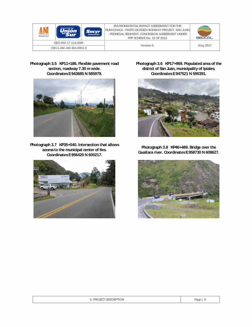
Photograph 3.5 KP11+186. Flexible pavement road section, roadway 7.30 m wide. ___________________ 9
Photograph 3.6 KP17+969. Populated area of the district of San Juan, municipality of Ipiales. __________ 9
Photograph 3.7 KP35+040. Intersection that allows access to the municipal center of Iles. Coordinates E 956420 N 600217. __________________________________________________________ 9
Photograph 3.8 KP46+489. Bridge over the Guaítara river. Coordinates E 958730 N 608627. ___________ 9
ENVIRONMENTAL IMPACT ASSESSMENT FOR THE RUMICHACA - PASTO DIVIDED HIGHWAY PROJECT, SAN JUAN
- PEDREGAL SEGMENT, CONCESSION AGREEMENT UNDER PPP SCHEME No. 15 OF 2015
GEO-002-17-114-EAM Version 0. May 2017
CSH-1-AM-AM-EIA-0001-0
3. PROJECT DESCRIPTION
CONTENTS
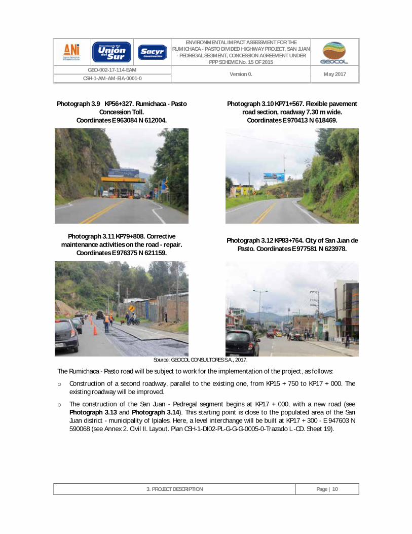
Photograph 3.9 KP56+327. Rumichaca - Pasto Concession Toll. Coordinates E 963084 N 612004. ______ 10
Photograph 3.10 KP71+567. Flexible pavement road section, roadway 7.30 m wide. Coordinates E 970413 N 618469. _________________________________________________________________ 10
Photograph 3.11 KP79+808. Corrective maintenance activities on the road - repair. Coordinates E 976375 N 621159. _________________________________________________________________ 10
Photograph 3.12 KP83+764. City of San Juan de Pasto. Coordinates E 977581 N 623978. ______________ 10
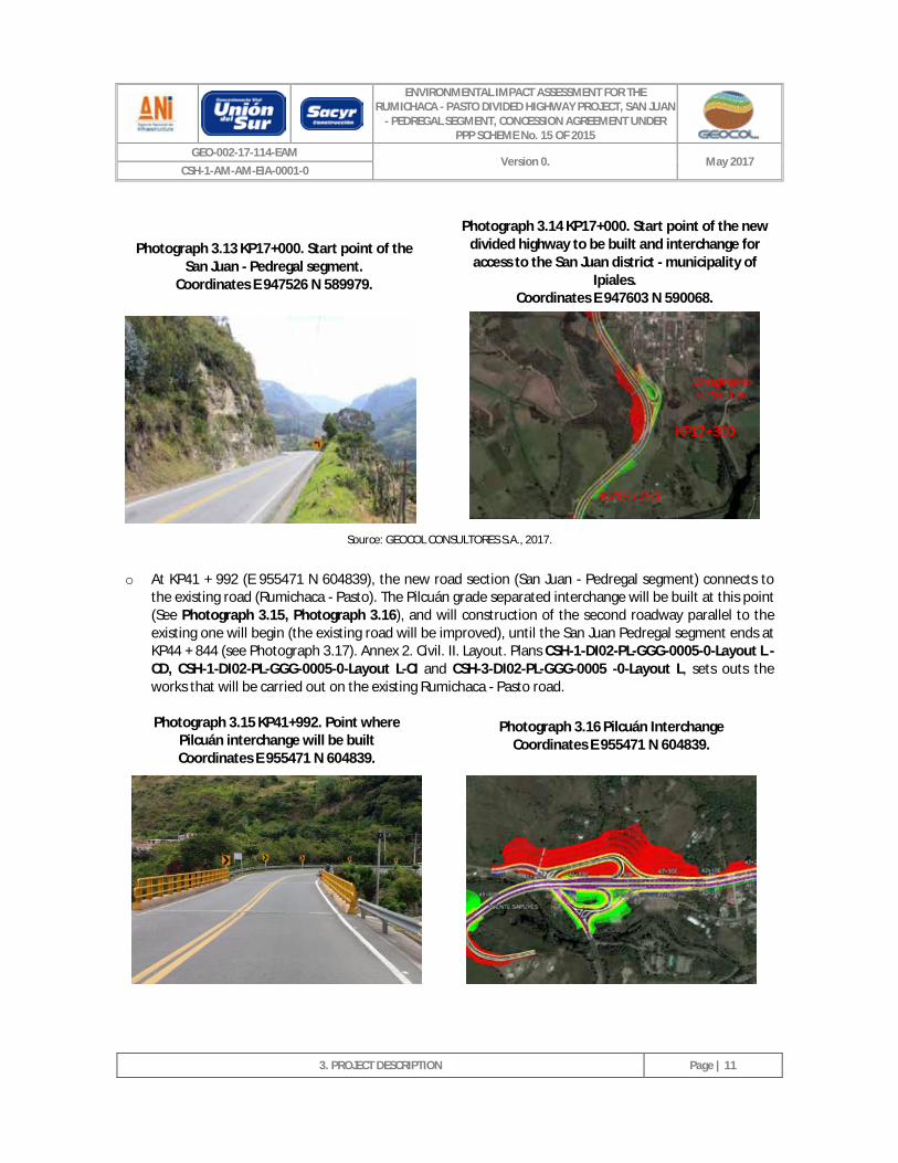
Photograph 3.13 KP17+000. Start point of the San Juan - Pedregal segment. Coordinates E 947526 N 589979. 11
Photograph 3.14 KP17+000. Start point of the new divided highway to be built and interchange for access to the San Juan district - municipality of Ipiales. Coordinates E 947603 N 590068. ________ 11
Photograph 3.15 KP41+992. Point where Pilcuán interchange will be built Coordinates E 955471 N 604839. 11
Photograph 3.16 Pilcuán Interchange Coordinates E 955471 N 604839. ____________________________ 11
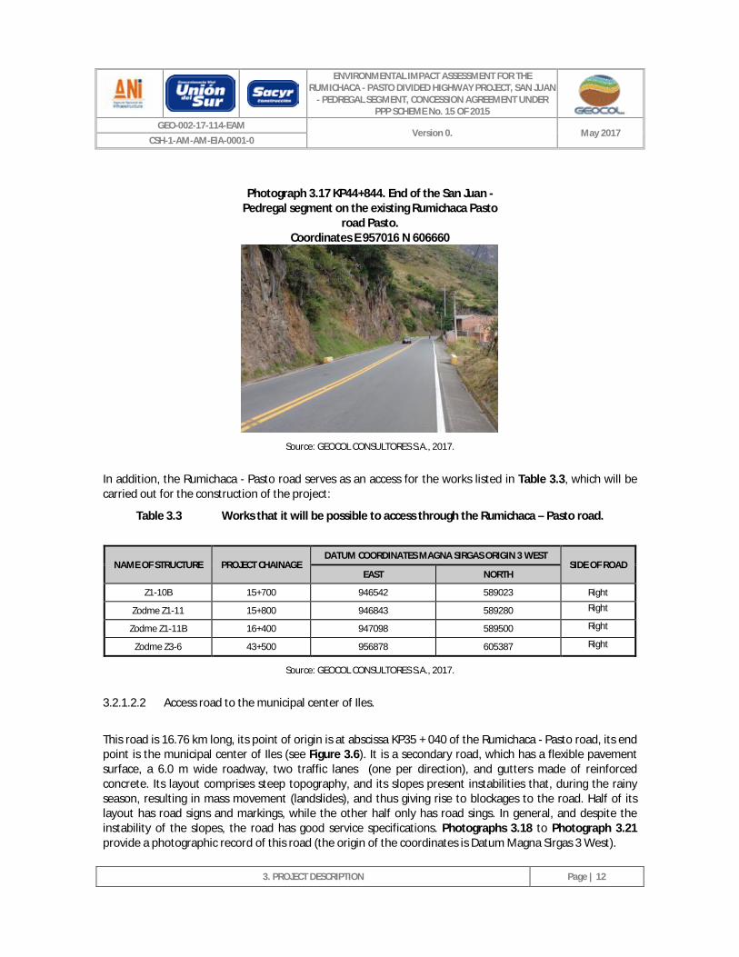
Photograph 3.17 KP44+844 End of the San Juan - Pedregal segment on the existing Rumichaca Pasto road Pasto. Coordinates E 957016 N 606660.
End of the San Juan - Pedregal segment on the Rumichaca Pasto road. Coordinates E 957016 N 606660 __ 12
Photograph 3.18 KP0+000. Point of origin of the access road to the municipal center of Iles. Coordinates E 956420 N 600217. _________________________________________________________ 14
Photograph 3.19 KP6+216. Landslide on the road. Coordinates E 953981 N 602027. __________________ 14
Photograph 3.20 KP7+732. Change in road characteristics. Flexible pavement, with a roadway up to 6.0 m wide, lacks road markings. Coordinates E 952902 N 601812. _______________________ 14
Photograph 3.21 KP16+763 . Municipal center of Iles. Coordinates E 950653 N 598997. _______________ 14
Photograph 3.22 KP3+673. Viaduct relating to the access road to Iles. Point where the les interchange will be built. Coordinates E 955162 N 601702. ________________________________________ 15
Photograph 3.23 KP3+372. Road section where the Iles interchange is planned. Coordinates E 955064 N601897. ________________________________________________________________ 15
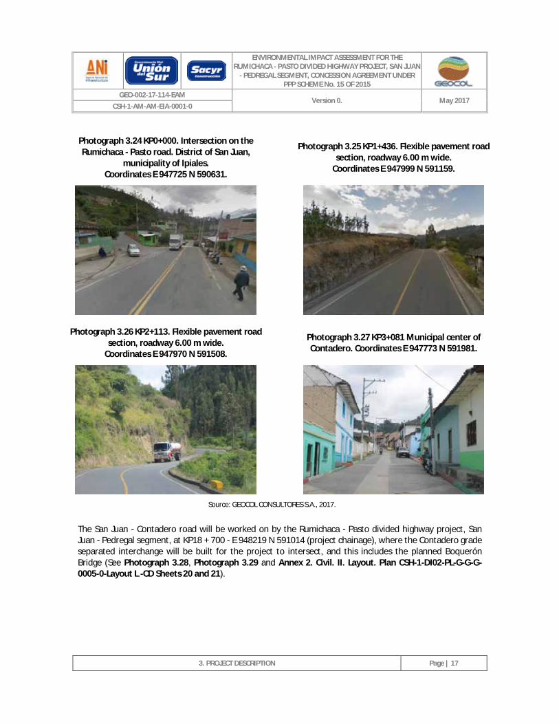
Photograph 3.24 KP0+000. Intersection on the Rumichaca - Pasto road. District of San Juan, municipality of Ipiales. Coordinates E 947725 N 590631._______________________________________ 17
Photograph 3.25 KP1+436. Flexible pavement road section, roadway 6.00 m wide. Coordinates E 947999 N 591159. _________________________________________________________________ 17
Photograph 3.26 KP2+113. Flexible pavement road section, roadway 6.00 m wide. Coordinates E 947970 N 591508. _________________________________________________________________ 17
Photograph 3.27 KP3+081 Municipal center of Contadero. Coordinates E 947773 N 591981. ___________ 17
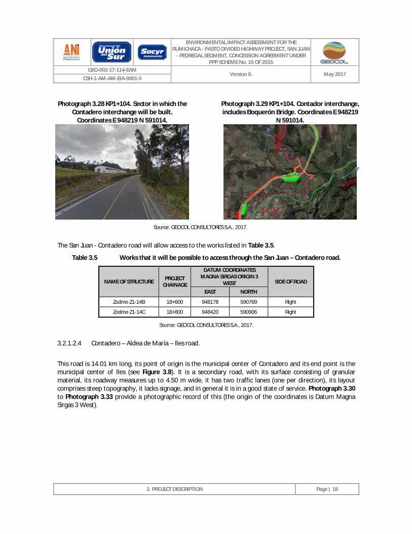
Photograph 3.28 KP1+104. Sector in which the Contadero interchange will be built. Coordinates E 948219 N 591014. _________________________________________________________________ 18
ENVIRONMENTAL IMPACT ASSESSMENT FOR THE RUMICHACA - PASTO DIVIDED HIGHWAY PROJECT, SAN JUAN
- PEDREGAL SEGMENT, CONCESSION AGREEMENT UNDER PPP SCHEME No. 15 OF 2015
GEO-002-17-114-EAM Version 0. May 2017
CSH-1-AM-AM-EIA-0001-0
3. PROJECT DESCRIPTION
CONTENTS
Photograph 3.29 KP1+104. Contador Interchange, includes Boquerón Bridge. Coordinates E 948219 N 591014. _________________________________________________________________ 18
Photograph 3.30 KP0+715. Road section, granular material, roadway 4.50 m wide. Coordinates E 947856 N 592436. _________________________________________________________________ 19
Photograph 3.31 KP3+358. Road section, granular material, roadway 4.50 m wide. Near to the populated area of the Aldea of María district - municipality of Contadero. Coordinates E 949699 N 592900. _________________________________________________________________ 19
Photograph 3.32 KP5+638. Road section, granular material, roadway 3.50 m wide. Coordinates E 950140 N 594145. _________________________________________________________________ 20
Photograph 3.33 KP8+687. Road section, granular material, roadway 3.50 m wide. Coordinates E 951300 N 595176. _________________________________________________________________ 20
Photograph 3.34 KP6+483. Section of the Contadero - Aldea de María - Iles road. Point of intersection for the Rumichaca - Pasto Divided Highway Project, San Juan - Pedregal segment. Coordinates E 950571 N 594552. _________________________________________________________ 20
Photograph 3.35 KP6+623. Section of the Contadero - Aldea de María - Iles road. Point of intersection for the Rumichaca - Pasto Divided Highway Project, San Juan - Pedregal segment. Coordinates E 950571 N 594552. _________________________________________________________ 20
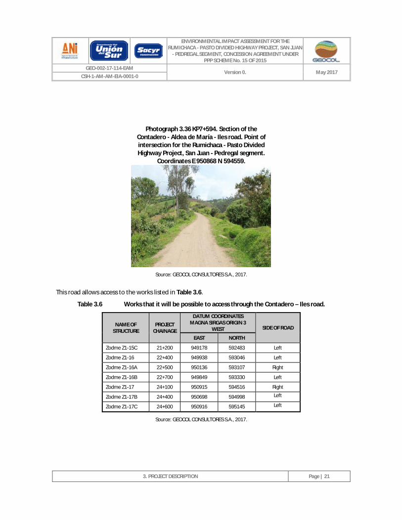
Photograph 3.36 KP7+594. Section of the Contadero - Aldea de María - Iles road. Point of intersection for the Rumichaca - Pasto Divided Highway Project, San Juan - Pedregal segment. Coordinates E 950868 N 594559. _________________________________________________________ 21
Photograph 3.37 KP0+561. Road section, granular material, roadway 3.00 m wide. Coordinates E 951897 N 595858. _________________________________________________________________ 23
Photograph 3.38 KP6+332. Road intersection. To the right, it allows access to the Rumichaca - Pasto road, and to the left to the municipal center of Iles. Coordinates E 955004 N 596723. _______ 23
Photograph 3.39 KP10+911. Road section, granular material, roadway 4.00 m wide. Coordinates E 954173 N 598736. _________________________________________________________________ 23
Photograph 3.40 KP15+831. Road section, granular material, roadway 4.00 m wide. Coordinates E 950747 N 598821. _________________________________________________________________ 23
Photograph 3.41 KP4+915. Section of the Ospina Pérez - Iles road. Point of intersection for the Rumichaca - Pasto Divided Highway Project, San Juan - Pedregal segment. Coordinates E 954204 N 596620. _________________________________________________________________ 24
Photograph 3.42 KP7+813. Section of the Ospina Pérez - Iles road. Point of intersection for the Rumichaca - Pasto Divided Highway Project, San Juan - Pedregal segment. Coordinates E 955398 N 597503. _________________________________________________________________ 24
Photograph 3.43 KP8+064. Section of the Ospina Pérez - Iles road. Point of intersection for the Rumichaca - Pasto Divided Highway Project, San Juan - Pedregal segment. Coordinates E 955613 N 597510. _________________________________________________________________ 24
ENVIRONMENTAL IMPACT ASSESSMENT FOR THE RUMICHACA - PASTO DIVIDED HIGHWAY PROJECT, SAN JUAN
- PEDREGAL SEGMENT, CONCESSION AGREEMENT UNDER PPP SCHEME No. 15 OF 2015
GEO-002-17-114-EAM Version 0. May 2017
CSH-1-AM-AM-EIA-0001-0
3. PROJECT DESCRIPTION
CONTENTS
Photograph 3.44 KP8+150. Section of the Ospina Pérez - Iles road. Point of intersection for the Rumichaca - Pasto Divided Highway Project, San Juan - Pedregal segment. Coordinates E 955662 N 597500. _________________________________________________________________ 24
Photograph 3.45 KP0+150. Road section, granular material, roadway 3.0 m wide. Coordinates E 955041 N 596594. _________________________________________________________________ 26
Photograph 3.46 KP1+706. Landslide on the road. Coordinates E 954962 N 595729. __________________ 26
Photograph 3.47 KP3+707. Road section with damage to surface due to lack of runoff water management. Coordinates E 955255 N 595908. _____________________________________________ 27
Photograph 3.48 KP5+396. Intersection with the Rumichaca Pasto road. Coordinates E 955672 N 595553. 27
Photograph 3.49 KP0+000. Intersection. Point of origin of the Iles - Pilcuán Viejo road. Coordinates E 955427 N 601176. _______________________________________________________________ 28
Photograph 3.50 KP2+080. Road section, granular material, roadway 3.0 m wide. Coordinates E 954701 N 602639. _________________________________________________________________ 28
Photograph 3.51 KP4+293. Road section, granular material, roadway 3.5 m wide. Coordinates E 954914 N 603811. _________________________________________________________________ 29
Photograph 3.52 KP4+860. Intersection with the Rumichaca – Pasto road. Coordinates E 955183 N 603749. 29
Photograph 3.53 KP0+000. Point of origin of the road. Coordinates E 955489 N 604929. ______________ 30
Photograph 3.54 KP0+635. Road section, granular material, roadway 3.00 m wide. Coordinates E 954931 N 605106. _________________________________________________________________ 30
Photograph 3.55 KP0+165. Section of the Pilcuán Viejo - Arco Iris Condominium road. Point of intersection for the Rumichaca - Pasto Divided Highway Project, San Juan - Pedregal segment. Coordinates E 955329 N 604958. _____________________________________________ 31
Photograph 3.56 KP2+205. Section of the Pilcuán Viejo - Arco Iris Condominium road. Point of intersection for the Rumichaca - Pasto Divided Highway Project, San Juan - Pedregal segment. Coordinates E 954016 N 604819. _____________________________________________ 31
Photograph 3.57 KP0+000. Point of origin of the internal road relating to the Arco Iris condominium and the project's point of intersection. Coordinates E 953979 N 604795 ____________________ 32
Photograph 3.58 KP0+691. Section of the internal road relating to the Arco Iris Condominium. Point of intersection for the Rumichaca - Pasto Divided Highway Project, San Juan - Pedregal segment. Coordinates E 953943 N 604451. _____________________________________ 32
Photograph 3.59 KP2+147. Road section, granular material, roadway 3.5 m wide. Coordinates E 954626 N 603780. _________________________________________________________________ 34
Photograph 3.60 KP2+769 Section of the Pilcuán Viejo – La Rejoya road. Point of intersection for the Rumichaca - Pasto Divided Highway Project, San Juan - Pedregal segment. Coordinates E 954426 N 604194. _________________________________________________________ 34
ENVIRONMENTAL IMPACT ASSESSMENT FOR THE RUMICHACA - PASTO DIVIDED HIGHWAY PROJECT, SAN JUAN
- PEDREGAL SEGMENT, CONCESSION AGREEMENT UNDER PPP SCHEME No. 15 OF 2015
GEO-002-17-114-EAM Version 0. May 2017
CSH-1-AM-AM-EIA-0001-0
3. PROJECT DESCRIPTION
CONTENTS
Photograph 3.61 KP3+055 Section of the Pilcuán Viejo – La Rejoya road. Point of intersection for the Rumichaca - Pasto Divided Highway Project, San Juan - Pedregal segment. Coordinates E 954509 N 604341. _________________________________________________________ 35
Photograph 3.62 KP3+318 Section of the Pilcuán Viejo – La Rejoya road. Point of intersection for the Rumichaca - Pasto Divided Highway Project, San Juan - Pedregal segment. Coordinates E 954520 N 604530. _________________________________________________________ 35
Photograph 3.63 KP0+306. Reinforced concrete bridge with a 4.5 x 7.5 m board. Coordinates E 947761 N 592374. _________________________________________________________________ 36
Photograph 3.64 KP1+206. Road section, granular material, roadway 3.0 m wide. Coordinates E 948044 N 591646. _________________________________________________________________ 36
Photograph 3.65 KP1+711. Road section, granular material, roadway 3.0 m wide. Coordinates E 948408 N 591596. _________________________________________________________________ 37
Photograph 3.66 KP1+897. Road section, granular material, roadway 3.0 m wide. Coordinates E 948470 N 591426. _________________________________________________________________ 37
Photograph 3.67 KP1+540. Section of the Contadero – San Francisco road. Point of intersection for the Rumichaca - Pasto Divided Highway Project, San Juan - Pedregal segment. Coordinates E 948252 N 591654. _________________________________________________________ 38
Photograph 3.68 KP0+028. Road section, granular material, roadway 3.5 m wide. Coordinates E 948520 N 592273. _________________________________________________________________ 39
Photograph 3.69 KP0+858. Road section, granular material, roadway 3.5 m wide. Coordinates E 949148 N 592245. _________________________________________________________________ 39
Photograph 3.70 KP0+069. Section of the access road to Ospina Pérez. Point where the Rumichaca - Pasto Divided Highway Project, San Juan - Pedregal segment will cross the road. Coordinates E 952879 N 595608. _________________________________________________________ 41
Photograph 3.71 KP0+373. Section of the access road to Ospina Pérez. Point where the Rumichaca - Pasto Divided Highway Project, San Juan - Pedregal segment will cross the road. Coordinates E 952637 N 595516 _________________________________________________________ 41
Photograph 3.72 KP1+181. Road section, granular material, roadway 2.5 m wide. Coordinates E 952171 N 595065. _________________________________________________________________ 41
Photograph 3.73 KP1+791. Road section – path. Coordinates E 951760 N 594774. ___________________ 41
Photograph 3.74 KP0+275. Section of the internal road relating to the San Juan village - municipality of Ipiales. Coordinates E 947635 N 590273._______________________________________ 42
Photograph 3.75 KP0+382. Road section, granular material, roadway 3.5 m wide. Coordinates E 947658 N 590169. _________________________________________________________________ 42
Photograph 3.76 KP0+747. Section of the San Juan - Loma de Suras village access road. Point where the Rumichaca - Pasto Divided Highway Project, San Juan - Pedregal segment will cross the road. Coordinates E 947725 N 590836. ________________________________________ 44
ENVIRONMENTAL IMPACT ASSESSMENT FOR THE RUMICHACA - PASTO DIVIDED HIGHWAY PROJECT, SAN JUAN
- PEDREGAL SEGMENT, CONCESSION AGREEMENT UNDER PPP SCHEME No. 15 OF 2015
GEO-002-17-114-EAM Version 0. May 2017
CSH-1-AM-AM-EIA-0001-0
3. PROJECT DESCRIPTION
CONTENTS
Photograph 3.77 KP0+914. Section of the San Juan - Loma de Suras village access road. Point where the Rumichaca - Pasto Divided Highway Project, San Juan - Pedregal segment will cross the road. Coordinates E 947624 N 590759. ________________________________________ 44
Photograph 3.78 KP0+110. Section of the access road to El Tesoro farm. Coordinates E 955602 N 600781. 45
Photograph 3.79 KP0+000. Point of origin of the access road to El Porvenir farm. Coordinates E 954705 N 601626. _________________________________________________________________ 47
Photograph 3.80 KP0+633. Road section at ground level, lacks runoff water management. Coordinates E 954919 N 601336. _________________________________________________________ 47
Photograph 3.81 KP0+683. Road section with slope instabilities. Coordinates E 954883 N 601307. ______ 48
Photograph 3.82 KP0+811. House belonging to El Porvenir farm. Coordinates E 954788 N 601278. ______ 48
ENVIRONMENTAL IMPACT ASSESSMENT FOR THE RUMICHACA - PASTO DIVIDED HIGHWAY PROJECT, SAN JUAN
- PEDREGAL SEGMENT, CONCESSION AGREEMENT UNDER PPP SCHEME No. 15 OF 2015
GEO-002-17-114-EAM Version 0. May 2017
CSH-1-AM-AM-EIA-0001-0
3. PROJECT DESCRIPTION
Page | 1
3 PROJECT DESCRIPTION
3.1 LOCATION
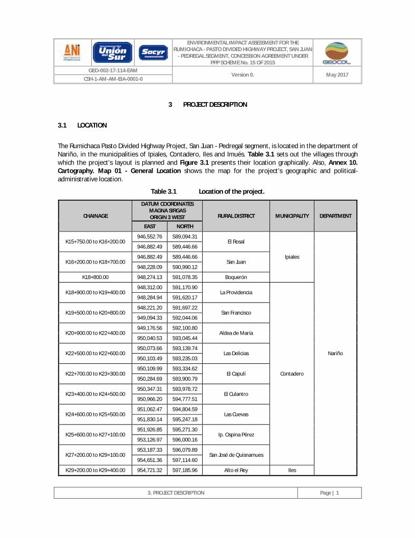
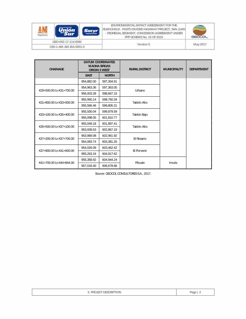
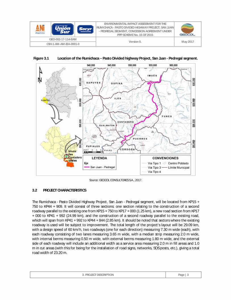
The Rumichaca Pasto Divided Highway Project, San Juan - Pedregal segment, is located in the department of Nariño, in the municipalities of Ipiales, Contadero, Iles and Imués. Table 3.1 sets out the villages through which the project's layout is planned and Figure 3.1 presents their location graphically. Also, Annex 10. Cartography. Map 01 - General Location shows the map for the project's geographic and political-administrative location.
Table 3.1 Location of the project.
CHAINAGE
DATUM COORDINATES MAGNA SIRGAS ORIGIN 3 WEST RURAL DISTRICT MUNICIPALITY DEPARTMENT
EAST NORTH
K15+750.00 to K16+200.00 946,552.76 589,094.31
El Rosal
Ipiales
Nariño
946,882.49 589,446.66
K16+200.00 to K18+700.00 946,882.49 589,446.66
San Juan 948,228.09 590,990.12
K18+800.00 948,274.13 591,078.35 Boquerón
K18+900.00 to K19+400.00 948,312.00 591,170.90
La Providencia
Contadero
948,284.94 591,620.17
K19+500.00 to K20+800.00 948,221.20 591,697.22
San Francisco 949,094.33 592,044.06
K20+900.00 to K22+400.00 949,176.56 592,100.80
Aldea de María 950,040.53 593,045.44
K22+500.00 to K22+600.00 950,073.66 593,139.74
Las Delicias 950,103.49 593,235.03
K22+700.00 to K23+300.00 950,109.99 593,334.62
El Capulí 950,284.69 593,900.79
K23+400.00 to K24+500.00 950,347.31 593,978.72
El Culantro 950,966.20 594,777.51
K24+600.00 to K25+500.00 951,062.47 594,804.59
Las Cuevas 951,830.14 595,247.18
K25+600.00 to K27+100.00 951,926.85 595,271.30
Ip. Ospina Pérez 953,126.97 596,000.16
K27+200.00 to K29+100.00 953,187.33 596,079.89
San José de Quisnamues 954,651.36 597,114.60
K29+200.00 to K29+400.00 954,721.32 597,185.96 Alto el Rey Iles
ENVIRONMENTAL IMPACT ASSESSMENT FOR THE RUMICHACA - PASTO DIVIDED HIGHWAY PROJECT, SAN JUAN
- PEDREGAL SEGMENT, CONCESSION AGREEMENT UNDER PPP SCHEME No. 15 OF 2015
GEO-002-17-114-EAM Version 0. May 2017
CSH-1-AM-AM-EIA-0001-0
3. PROJECT DESCRIPTION
Page | 2
CHAINAGE
DATUM COORDINATES MAGNA SIRGAS ORIGIN 3 WEST RURAL DISTRICT MUNICIPALITY DEPARTMENT
EAST NORTH
954,882.00 597,304.91
K29+500.00 to K31+700.00 954,963.36 597,363.05
Urbano 956,003.28 598,667.15
K31+800.00 to K33+000.00 955,950.14 598,750.34
Tablón Alto 955,566.46 599,805.31
K33+100.00 to K35+400.00 955,500.04 599,879.59
Tablón Bajo 955,098.05 601,810.77
K35+500.00 to K37+100.00 955,049.18 601,897.41
Tablón Alto 953,939.53 602,867.19
K37+200.00 to K37+700.00 953,969.08 602,961.92
El Rosario 954,083.74 603,381.25
K37+800.00 to K41+600.00 954,026.09 603,462.42
El Porvenir 955,263.24 604,917.62
K41+700.00 to K44+844.00 955,358.92 604,944.24
Pilcuán Imués 957,018.40 606,678.66
Source: GEOCOL CONSULTORES S.A., 2017.
ENVIRONMENTAL IMPACT ASSESSMENT FOR THE RUMICHACA - PASTO DIVIDED HIGHWAY PROJECT, SAN JUAN
- PEDREGAL SEGMENT, CONCESSION AGREEMENT UNDER PPP SCHEME No. 15 OF 2015
GEO-002-17-114-EAM Version 0. May 2017
CSH-1-AM-AM-EIA-0001-0
3. PROJECT DESCRIPTION
Page | 3
Figure 3.1 Location of the Rumichaca – Pasto Divided highway Project, San Juan - Pedregal segment.
Source: GEOCOL CONSULTORES S.A., 2017.
3.2 PROJECT CHARACTERISTICS
The Rumichaca - Pasto Divided Highway Project, San Juan - Pedregal segment, will be located from KP15 + 750 to KP44 + 909. It will consist of three sections: one section relating to the construction of a second roadway parallel to the existing one from KP15 + 750 to KP17 + 000 (1.25 km), a new road section from KP17 + 000 to KP41 + 992 (24.99 km), and the construction of a second roadway parallel to the existing road, which will span from KP41 + 992 to KP44 + 844 (2.85 km). It should be noted that sectors where the existing roadway is used will be subject to improvement. The total length of the project's layout will be 29.09 km, with a design speed of 60 km/h, two roadways (one for each direction) measuring 7.30 m wide (each), with each roadway consisting of two lanes measuring 3.65 m wide, with a median strip measuring 2.0 m wide, with internal berms measuring 0.50 m wide, with external berms measuring 1.80 m wide, and the external side of each roadway will include an additional width as a service area measuring 2.0 m in fill areas and 1.0 m in cut areas (with this for being for the installation of road signs, networks, SOS posts, etc.), giving a total road width of 23.20 m.
ENVIRONMENTAL IMPACT ASSESSMENT FOR THE RUMICHACA - PASTO DIVIDED HIGHWAY PROJECT, SAN JUAN
- PEDREGAL SEGMENT, CONCESSION AGREEMENT UNDER PPP SCHEME No. 15 OF 2015
GEO-002-17-114-EAM Version 0. May 2017
CSH-1-AM-AM-EIA-0001-0
3. PROJECT DESCRIPTION
Page | 4
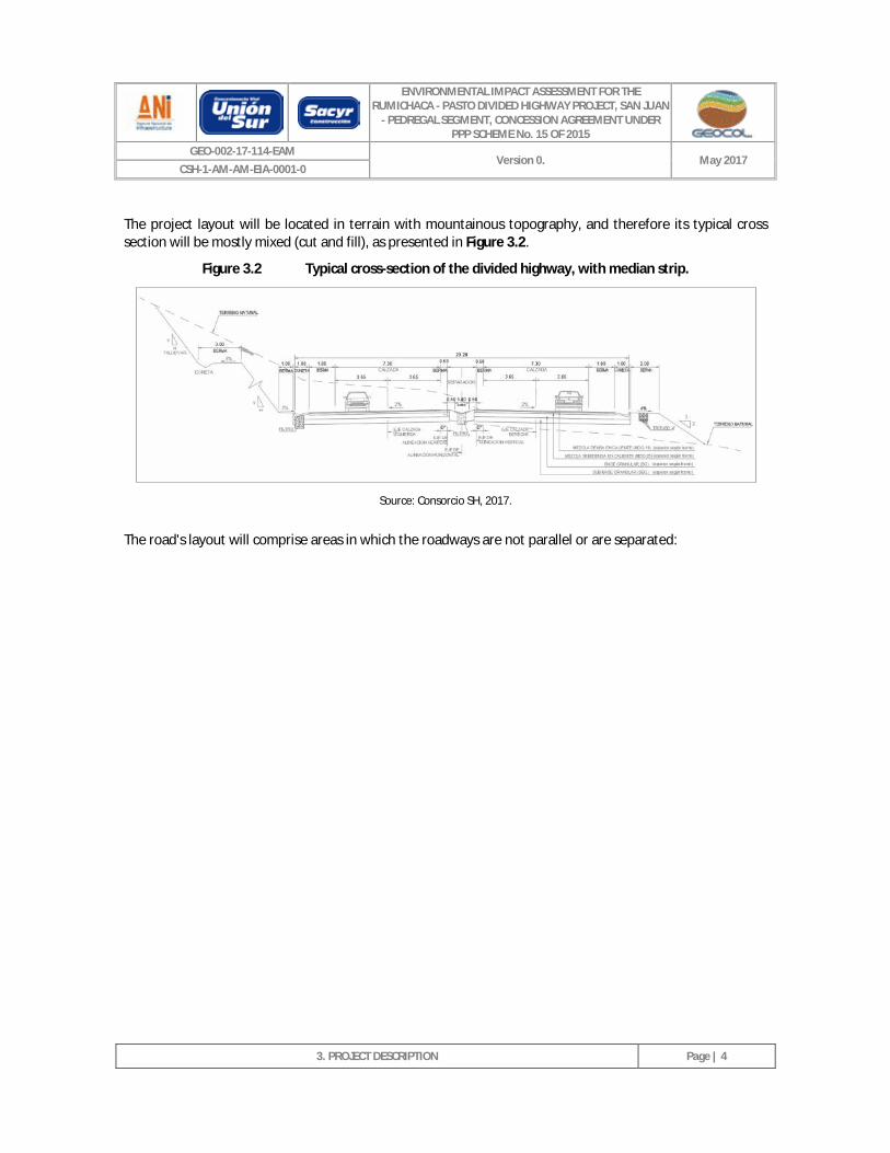
The project layout will be located in terrain with mountainous topography, and therefore its typical cross section will be mostly mixed (cut and fill), as presented in Figure 3.2.
Figure 3.2 Typical cross-section of the divided highway, with median strip.
Source: Consorcio SH, 2017.
The road's layout will comprise areas in which the roadways are not parallel or are separated:
ENVIRONMENTAL IMPACT ASSESSMENT FOR THE RUMICHACA - PASTO DIVIDED HIGHWAY PROJECT, SAN JUAN
- PEDREGAL SEGMENT, CONCESSION AGREEMENT UNDER PPP SCHEME No. 15 OF 2015
GEO-002-17-114-EAM Version 0. May 2017
CSH-1-AM-AM-EIA-0001-0
3. PROJECT DESCRIPTION
Page | 5
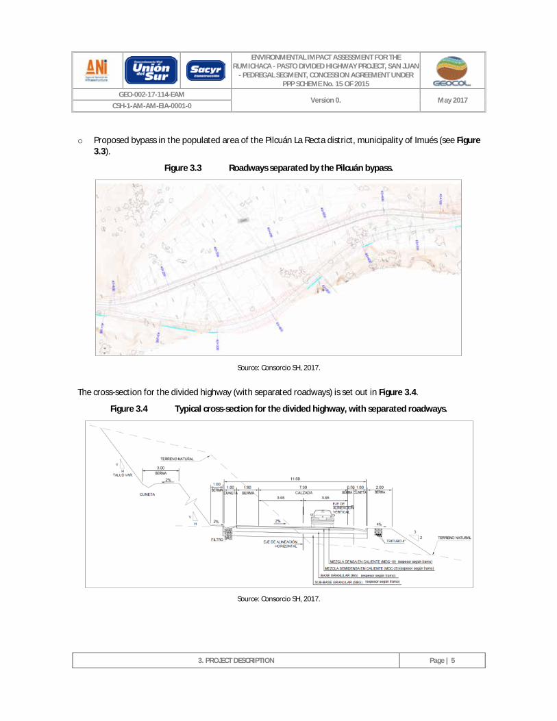
o Proposed bypass in the populated area of the Pilcuán La Recta district, municipality of Imués (see Figure 3.3).
Figure 3.3 Roadways separated by the Pilcuán bypass.
Source: Consorcio SH, 2017.
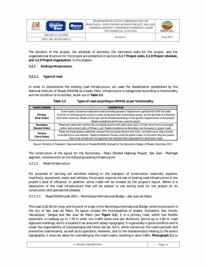
The cross-section for the divided highway (with separated roadways) is set out in Figure 3.4.
Figure 3.4 Typical cross-section for the divided highway, with separated roadways.
Source: Consorcio SH, 2017.
ENVIRONMENTAL IMPACT ASSESSMENT FOR THE RUMICHACA - PASTO DIVIDED HIGHWAY PROJECT, SAN JUAN
- PEDREGAL SEGMENT, CONCESSION AGREEMENT UNDER PPP SCHEME No. 15 OF 2015
GEO-002-17-114-EAM Version 0. May 2017
CSH-1-AM-AM-EIA-0001-0
3. PROJECT DESCRIPTION
Page | 6
The duration of the project, the schedule of activities, the estimated costs for the project, and the organizational structure for the project are presented in sections 3.2.7 Project costs, 3.2.8 Project schedule, and 3.2.9 Project organization, in this chapter.
3.2.1 Existing infrastructure.
3.2.1.1 Types of road.
In order to characterize the existing road infrastructure, we used the classification established by the National Institute of Roads (INVIAS) as a basis. Here, infrastructure is categorized according to functionality and the condition of its surface, as set out in Table 3.2.
Table 3.2 Types of road according to INVIAS, as per functionality
NAME (ORDER) DESCRIPTION
Primary (First Order)
Trunk roads, transverse roads and roads providing access to department capitals that fulfill the basic function of connecting the country’s main production and consumption zones, as well as those of Colombia with other countries. Roads of this type can be divided according to the specific requirements of the project.
Roads considered as Primary must be paved. Secondary
(Second Order) These are roads that connect the municipal centers with each other and / or that come from a municipal
center and connect with a Primary road. Roads considered as Secondary can be paved or gravel roads.
Tertiary (Third Order)
These are those access roads that connect the municipal centers with their rural districts or that connect rural districts to one another. Roads considered Tertiary must be gravel roads. In the event they are paved,
they must comply with the geometrical characteristics stipulated for secondary roads
Source: Ministry of Transport, National Institute of Roads (INVIAS), Manual for the Geometric Design of Roads, Colombia, 2017.
The construction of the layout for the Rumichaca - Pasto Divided Highway Project, San Juan - Pedregal segment, involves work on the following existing infrastructure:
3.2.1.2 Road infrastructure.
For purposes of carrying out activities relating to the transport of construction materials, supplies, machinery, equipment, waste and vehicles, the project requires the use of existing road infrastructure in the project’s area of influence. In addition, some roads will be crossed by the project's layout. Below is a description of the road infrastructure that will be subject to use during work for the project (in its construction and operational phases):
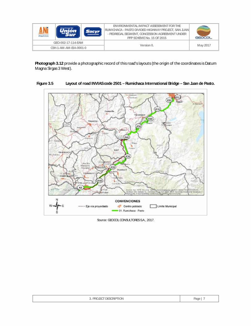
3.2.1.2.1 Road INVIAS code 2501 – Rumichaca International Bridge – San Juan de Pasto.
This road is 82.60 km long, and its point of origin is the Rumichaca International Bridge, while its end point is the city of San Juan de Pasto. Its layout crosses the municipalities of Ipiales, Contadero, Iles, Imués, Yacuanquer, Tangua and San Juan de Pasto (see Figure 3.5). It is a primary road, which has flexible pavement, a roadway up to 7.30 m wide, two traffic lanes (one per direction), berms up to 1.80 m, road signs and markings, and it is located in an area with steep topography. It is generally in good condition and is under the responsibility of Concesionaria Vial Unión del Sur S.A.S., which carries out the road's periodic and preventive maintenance, as well as its operation. However, due to the characteristics relating to the area's topography, it does not allow for overtaking by the road's users, resulting in slow traffic. Photograph 3.1 to
ENVIRONMENTAL IMPACT ASSESSMENT FOR THE RUMICHACA - PASTO DIVIDED HIGHWAY PROJECT, SAN JUAN
- PEDREGAL SEGMENT, CONCESSION AGREEMENT UNDER PPP SCHEME No. 15 OF 2015
GEO-002-17-114-EAM Version 0. May 2017
CSH-1-AM-AM-EIA-0001-0
3. PROJECT DESCRIPTION
Page | 7
Photograph 3.12 provide a photographic record of this road's layouts (the origin of the coordinates is Datum Magna Sirgas 3 West).
Figure 3.5 Layout of road INVIAS code 2501 – Rumichaca International Bridge – San Juan de Pasto.
Source: GEOCOL CONSULTORES S.A., 2017.
ENVIRONMENTAL IMPACT ASSESSMENT FOR THE RUMICHACA - PASTO DIVIDED HIGHWAY PROJECT, SAN JUAN
- PEDREGAL SEGMENT, CONCESSION AGREEMENT UNDER PPP SCHEME No. 15 OF 2015
GEO-002-17-114-EAM Version 0. May 2017
CSH-1-AM-AM-EIA-0001-0
3. PROJECT DESCRIPTION
Page | 8
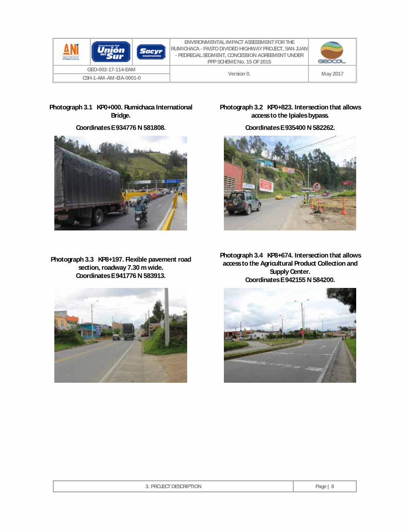
Photograph 3.1 KP0+000. Rumichaca International Bridge.
Coordinates E 934776 N 581808.
Photograph 3.2 KP0+823. Intersection that allows access to the Ipiales bypass.
Coordinates E 935400 N 582262.
Photograph 3.3 KP8+197. Flexible pavement road section, roadway 7.30 m wide.
Coordinates E 941776 N 583913.
Photograph 3.4 KP8+674. Intersection that allows access to the Agricultural Product Collection and
Supply Center. Coordinates E 942155 N 584200.
ENVIRONMENTAL IMPACT ASSESSMENT FOR THE RUMICHACA - PASTO DIVIDED HIGHWAY PROJECT, SAN JUAN
- PEDREGAL SEGMENT, CONCESSION AGREEMENT UNDER PPP SCHEME No. 15 OF 2015
GEO-002-17-114-EAM Version 0. May 2017
CSH-1-AM-AM-EIA-0001-0
3. PROJECT DESCRIPTION
Page | 9
Photograph 3.5 KP11+186. Flexible pavement road section, roadway 7.30 m wide.
Coordinates E 943685 N 585979.
Photograph 3.6 KP17+969. Populated area of the district of San Juan, municipality of Ipiales.
Coordinates E 947521 N 590391.
Photograph 3.7 KP35+040. Intersection that allows access to the municipal center of Iles.
Coordinates E 956420 N 600217. Photograph 3.8 KP46+489. Bridge over the
Guaítara river. Coordinates E 958730 N 608627.
ENVIRONMENTAL IMPACT ASSESSMENT FOR THE RUMICHACA - PASTO DIVIDED HIGHWAY PROJECT, SAN JUAN
- PEDREGAL SEGMENT, CONCESSION AGREEMENT UNDER PPP SCHEME No. 15 OF 2015
GEO-002-17-114-EAM Version 0. May 2017
CSH-1-AM-AM-EIA-0001-0
3. PROJECT DESCRIPTION
Page | 10
Photograph 3.9 KP56+327. Rumichaca - Pasto Concession Toll.
Coordinates E 963084 N 612004.
Photograph 3.10 KP71+567. Flexible pavement road section, roadway 7.30 m wide.
Coordinates E 970413 N 618469.
Photograph 3.11 KP79+808. Corrective maintenance activities on the road - repair.
Coordinates E 976375 N 621159. Photograph 3.12 KP83+764. City of San Juan de
Pasto. Coordinates E 977581 N 623978.
Source: GEOCOL CONSULTORES S.A., 2017.
The Rumichaca - Pasto road will be subject to work for the implementation of the project, as follows:
o Construction of a second roadway, parallel to the existing one, from KP15 + 750 to KP17 + 000. The existing roadway will be improved.
o The construction of the San Juan - Pedregal segment begins at KP17 + 000, with a new road (see Photograph 3.13 and Photograph 3.14). This starting point is close to the populated area of the San Juan district - municipality of Ipiales. Here, a level interchange will be built at KP17 + 300 - E 947603 N 590068 (see Annex 2. Civil II. Layout. Plan CSH-1-DI02-PL-G-G-G-0005-0-Trazado L -CD. Sheet 19).
ENVIRONMENTAL IMPACT ASSESSMENT FOR THE RUMICHACA - PASTO DIVIDED HIGHWAY PROJECT, SAN JUAN
- PEDREGAL SEGMENT, CONCESSION AGREEMENT UNDER PPP SCHEME No. 15 OF 2015
GEO-002-17-114-EAM Version 0. May 2017
CSH-1-AM-AM-EIA-0001-0
3. PROJECT DESCRIPTION
Page | 11
Photograph 3.13 KP17+000. Start point of the San Juan - Pedregal segment.
Coordinates E 947526 N 589979.
Photograph 3.14 KP17+000. Start point of the new divided highway to be built and interchange for access to the San Juan district - municipality of
Ipiales. Coordinates E 947603 N 590068.
Source: GEOCOL CONSULTORES S.A., 2017.
o At KP41 + 992 (E 955471 N 604839), the new road section (San Juan - Pedregal segment) connects to the existing road (Rumichaca - Pasto). The Pilcuán grade separated interchange will be built at this point (See Photograph 3.15, Photograph 3.16), and will construction of the second roadway parallel to the existing one will begin (the existing road will be improved), until the San Juan Pedregal segment ends at KP44 + 844 (see Photograph 3.17). Annex 2. Civil. II. Layout. Plans CSH-1-DI02-PL-GGG-0005-0-Layout L -CD, CSH-1-DI02-PL-GGG-0005-0-Layout L-CI and CSH-3-DI02-PL-GGG-0005 -0-Layout L, sets outs the works that will be carried out on the existing Rumichaca - Pasto road.
Photograph 3.15 KP41+992. Point where Pilcuán interchange will be built Coordinates E 955471 N 604839.
Photograph 3.16 Pilcuán Interchange Coordinates E 955471 N 604839.
KP15+750
Corregimiento de San Juan
KP17+300
ENVIRONMENTAL IMPACT ASSESSMENT FOR THE RUMICHACA - PASTO DIVIDED HIGHWAY PROJECT, SAN JUAN
- PEDREGAL SEGMENT, CONCESSION AGREEMENT UNDER PPP SCHEME No. 15 OF 2015
GEO-002-17-114-EAM Version 0. May 2017
CSH-1-AM-AM-EIA-0001-0
3. PROJECT DESCRIPTION
Page | 12
Photograph 3.17 KP44+844. End of the San Juan - Pedregal segment on the existing Rumichaca Pasto
road Pasto. Coordinates E 957016 N 606660
Source: GEOCOL CONSULTORES S.A., 2017.
In addition, the Rumichaca - Pasto road serves as an access for the works listed in Table 3.3, which will be carried out for the construction of the project:
Table 3.3 Works that it will be possible to access through the Rumichaca – Pasto road.
NAME OF STRUCTURE PROJECT CHAINAGE DATUM COORDINATES MAGNA SIRGAS ORIGIN 3 WEST
SIDE OF ROAD EAST NORTH
Z1-10B 15+700 946542 589023 Right
Zodme Z1-11 15+800 946843 589280 Right
Zodme Z1-11B 16+400 947098 589500 Right
Zodme Z3-6 43+500 956878 605387 Right
Source: GEOCOL CONSULTORES S.A., 2017.
3.2.1.2.2 Access road to the municipal center of Iles.
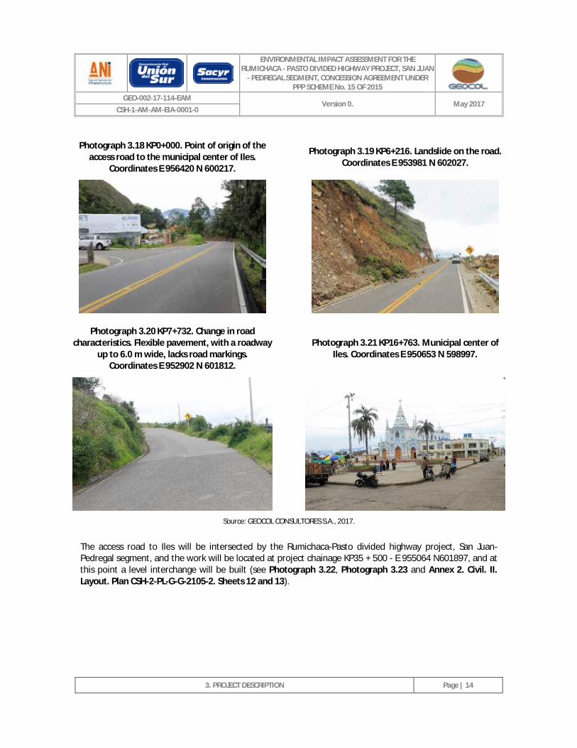
This road is 16.76 km long, its point of origin is at abscissa KP35 + 040 of the Rumichaca - Pasto road, its end point is the municipal center of Iles (see Figure 3.6). It is a secondary road, which has a flexible pavement surface, a 6.0 m wide roadway, two traffic lanes (one per direction), and gutters made of reinforced concrete. Its layout comprises steep topography, and its slopes present instabilities that, during the rainy season, resulting in mass movement (landslides), and thus giving rise to blockages to the road. Half of its layout has road signs and markings, while the other half only has road sings. In general, and despite the instability of the slopes, the road has good service specifications. Photographs 3.18 to Photograph 3.21 provide a photographic record of this road (the origin of the coordinates is Datum Magna Sirgas 3 West).
ENVIRONMENTAL IMPACT ASSESSMENT FOR THE RUMICHACA - PASTO DIVIDED HIGHWAY PROJECT, SAN JUAN
- PEDREGAL SEGMENT, CONCESSION AGREEMENT UNDER PPP SCHEME No. 15 OF 2015
GEO-002-17-114-EAM Version 0. May 2017
CSH-1-AM-AM-EIA-0001-0
3. PROJECT DESCRIPTION
Page | 13
Figure 3.6 Layout of the access road to the municipal center of Iles.
Source: GEOCOL CONSULTORES S.A., 2017.
ENVIRONMENTAL IMPACT ASSESSMENT FOR THE RUMICHACA - PASTO DIVIDED HIGHWAY PROJECT, SAN JUAN
- PEDREGAL SEGMENT, CONCESSION AGREEMENT UNDER PPP SCHEME No. 15 OF 2015
GEO-002-17-114-EAM Version 0. May 2017
CSH-1-AM-AM-EIA-0001-0
3. PROJECT DESCRIPTION
Page | 14
Photograph 3.18 KP0+000. Point of origin of the access road to the municipal center of Iles.
Coordinates E 956420 N 600217. Photograph 3.19 KP6+216. Landslide on the road.
Coordinates E 953981 N 602027.
Photograph 3.20 KP7+732. Change in road characteristics. Flexible pavement, with a roadway
up to 6.0 m wide, lacks road markings. Coordinates E 952902 N 601812.
Photograph 3.21 KP16+763. Municipal center of Iles. Coordinates E 950653 N 598997.
Source: GEOCOL CONSULTORES S.A., 2017.
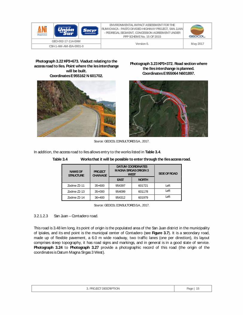
The access road to Iles will be intersected by the Rumichaca-Pasto divided highway project, San Juan-Pedregal segment, and the work will be located at project chainage KP35 + 500 - E 955064 N601897, and at this point a level interchange will be built (see Photograph 3.22, Photograph 3.23 and Annex 2. Civil. II. Layout. Plan CSH-2-PL-G-G-2105-2. Sheets 12 and 13).
ENVIRONMENTAL IMPACT ASSESSMENT FOR THE RUMICHACA - PASTO DIVIDED HIGHWAY PROJECT, SAN JUAN
- PEDREGAL SEGMENT, CONCESSION AGREEMENT UNDER PPP SCHEME No. 15 OF 2015
GEO-002-17-114-EAM Version 0. May 2017
CSH-1-AM-AM-EIA-0001-0
3. PROJECT DESCRIPTION
Page | 15
Photograph 3.22 KP3+673. Viaduct relating to the access road to Iles. Point where the les interchange
will be built. Coordinates E 955162 N 601702.
Photograph 3.23 KP3+372. Road section where
the Iles interchange is planned. Coordinates E 955064 N601897.
Source: GEOCOL CONSULTORES S.A., 2017.
In addition, the access road to Iles allows entry to the works listed in Table 3.4.
Table 3.4 Works that it will be possible to enter through the Iles access road.
NAME OF STRUCTURE
PROJECT CHAINAGE
DATUM COORDINATES MAGNA SIRGAS ORIGIN 3
WEST SIDE OF ROAD
EAST NORTH
Zodme Z2-11 35+600 954397 601721 Left
Zodme Z2-13 35+000 954099 601178 Left
Zodme Z2-14 36+400 954312 601979 Left
Source: GEOCOL CONSULTORES S.A., 2017.
3.2.1.2.3 San Juan – Contadero road.
This road is 3.48 km long, its point of origin is the populated area of the San Juan district in the municipality of Ipiales, and its end point is the municipal center of Contadero (see Figure 3.7). It is a secondary road, made up of flexible pavement, a 6.0 m wide roadway, two traffic lanes (one per direction), its layout comprises steep topography, it has road signs and markings, and in general is in a good state of service. Photograph 3.24 to Photograph 3.27 provide a photographic record of this road (the origin of the coordinates is Datum Magna Sirgas 3 West).
ENVIRONMENTAL IMPACT ASSESSMENT FOR THE RUMICHACA - PASTO DIVIDED HIGHWAY PROJECT, SAN JUAN
- PEDREGAL SEGMENT, CONCESSION AGREEMENT UNDER PPP SCHEME No. 15 OF 2015
GEO-002-17-114-EAM Version 0. May 2017
CSH-1-AM-AM-EIA-0001-0
3. PROJECT DESCRIPTION
Page | 16
Figure 3.7 Layout of the San Juan – Contadero road.
Source: GEOCOL CONSULTORES S.A., 2017.
ENVIRONMENTAL IMPACT ASSESSMENT FOR THE RUMICHACA - PASTO DIVIDED HIGHWAY PROJECT, SAN JUAN
- PEDREGAL SEGMENT, CONCESSION AGREEMENT UNDER PPP SCHEME No. 15 OF 2015
GEO-002-17-114-EAM Version 0. May 2017
CSH-1-AM-AM-EIA-0001-0
3. PROJECT DESCRIPTION
Page | 17
Photograph 3.24 KP0+000. Intersection on the Rumichaca - Pasto road. District of San Juan,
municipality of Ipiales. Coordinates E 947725 N 590631.
Photograph 3.25 KP1+436. Flexible pavement road
section, roadway 6.00 m wide. Coordinates E 947999 N 591159.
Photograph 3.26 KP2+113. Flexible pavement road section, roadway 6.00 m wide.
Coordinates E 947970 N 591508. Photograph 3.27 KP3+081 Municipal center of
Contadero. Coordinates E 947773 N 591981.
Source: GEOCOL CONSULTORES S.A., 2017.
The San Juan - Contadero road will be worked on by the Rumichaca - Pasto divided highway project, San Juan - Pedregal segment, at KP18 + 700 - E 948219 N 591014 (project chainage), where the Contadero grade separated interchange will be built for the project to intersect, and this includes the planned Boquerón Bridge (See Photograph 3.28, Photograph 3.29 and Annex 2. Civil. II. Layout. Plan CSH-1-DI02-PL-G-G-G-0005-0-Layout L -CD Sheets 20 and 21).
ENVIRONMENTAL IMPACT ASSESSMENT FOR THE RUMICHACA - PASTO DIVIDED HIGHWAY PROJECT, SAN JUAN
- PEDREGAL SEGMENT, CONCESSION AGREEMENT UNDER PPP SCHEME No. 15 OF 2015
GEO-002-17-114-EAM Version 0. May 2017
CSH-1-AM-AM-EIA-0001-0
3. PROJECT DESCRIPTION
Page | 18
Photograph 3.28 KP1+104. Sector in which the Contadero interchange will be built.
Coordinates E 948219 N 591014.
Photograph 3.29 KP1+104. Contador interchange, includes Boquerón Bridge. Coordinates E 948219
N 591014.
Source: GEOCOL CONSULTORES S.A., 2017.
The San Juan - Contadero road will allow access to the works listed in Table 3.5.
Table 3.5 Works that it will be possible to access through the San Juan – Contadero road.
NAME OF STRUCTURE PROJECT CHAINAGE
DATUM COORDINATES MAGNA SIRGAS ORIGIN 3
WEST SIDE OF ROAD
EAST NORTH
Zodme Z1-14B 18+600 948178 590769 Right
Zodme Z1-14C 18+800 948420 590906 Right
Source: GEOCOL CONSULTORES S.A., 2017.
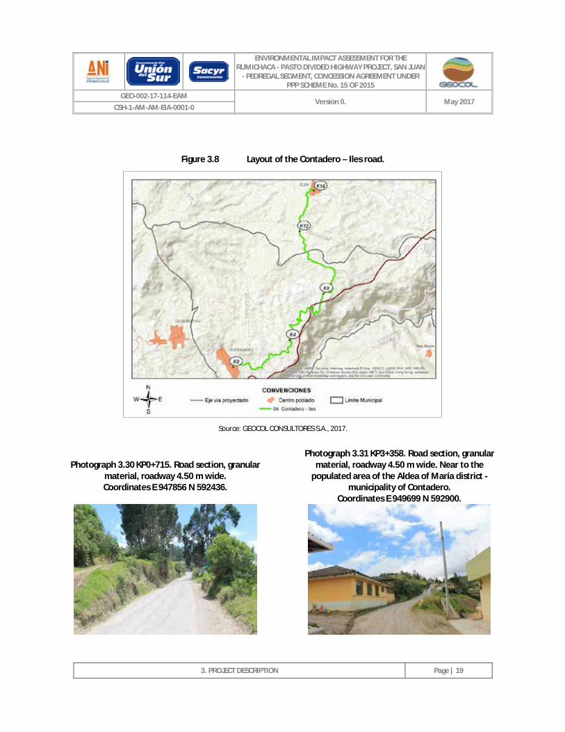
3.2.1.2.4 Contadero – Aldea de María – Iles road.
This road is 14.01 km long, its point of origin is the municipal center of Contadero and its end point is the municipal center of Iles (see Figure 3.8). It is a secondary road, with its surface consisting of granular material, its roadway measures up to 4.50 m wide, it has two traffic lanes (one per direction), its layout comprises steep topography, it lacks signage, and in general it is in a good state of service. Photograph 3.30 to Photograph 3.33 provide a photographic record of this (the origin of the coordinates is Datum Magna Sirgas 3 West).
San Juan
ENVIRONMENTAL IMPACT ASSESSMENT FOR THE RUMICHACA - PASTO DIVIDED HIGHWAY PROJECT, SAN JUAN
- PEDREGAL SEGMENT, CONCESSION AGREEMENT UNDER PPP SCHEME No. 15 OF 2015
GEO-002-17-114-EAM Version 0. May 2017
CSH-1-AM-AM-EIA-0001-0
3. PROJECT DESCRIPTION
Page | 19
Figure 3.8 Layout of the Contadero – Iles road.
Source: GEOCOL CONSULTORES S.A., 2017.
Photograph 3.30 KP0+715. Road section, granular material, roadway 4.50 m wide. Coordinates E 947856 N 592436.
Photograph 3.31 KP3+358. Road section, granular material, roadway 4.50 m wide. Near to the
populated area of the Aldea of María district - municipality of Contadero.
Coordinates E 949699 N 592900.
ENVIRONMENTAL IMPACT ASSESSMENT FOR THE RUMICHACA - PASTO DIVIDED HIGHWAY PROJECT, SAN JUAN
- PEDREGAL SEGMENT, CONCESSION AGREEMENT UNDER PPP SCHEME No. 15 OF 2015
GEO-002-17-114-EAM Version 0. May 2017
CSH-1-AM-AM-EIA-0001-0
3. PROJECT DESCRIPTION
Page | 20
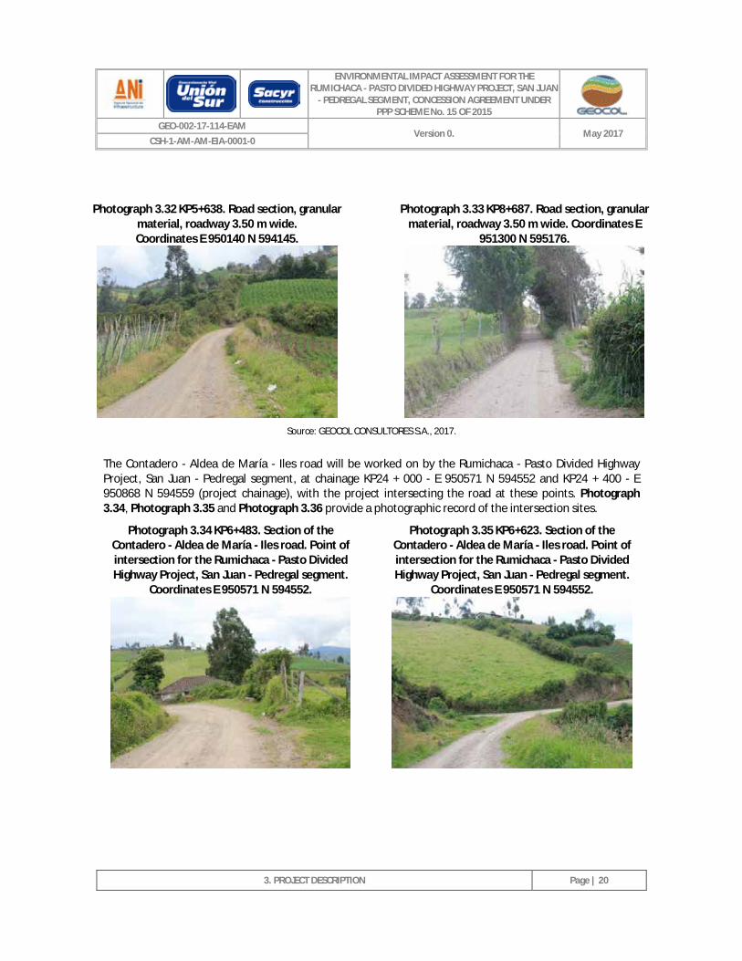
Photograph 3.32 KP5+638. Road section, granular
material, roadway 3.50 m wide. Coordinates E 950140 N 594145.
Photograph 3.33 KP8+687. Road section, granular
material, roadway 3.50 m wide. Coordinates E 951300 N 595176.
Source: GEOCOL CONSULTORES S.A., 2017.
The Contadero - Aldea de María - Iles road will be worked on by the Rumichaca - Pasto Divided Highway Project, San Juan - Pedregal segment, at chainage KP24 + 000 - E 950571 N 594552 and KP24 + 400 - E 950868 N 594559 (project chainage), with the project intersecting the road at these points. Photograph 3.34, Photograph 3.35 and Photograph 3.36 provide a photographic record of the intersection sites.
Photograph 3.34 KP6+483. Section of the Contadero - Aldea de María - Iles road. Point of intersection for the Rumichaca - Pasto Divided Highway Project, San Juan - Pedregal segment.
Coordinates E 950571 N 594552.
Photograph 3.35 KP6+623. Section of the Contadero - Aldea de María - Iles road. Point of intersection for the Rumichaca - Pasto Divided Highway Project, San Juan - Pedregal segment.
Coordinates E 950571 N 594552.
ENVIRONMENTAL IMPACT ASSESSMENT FOR THE RUMICHACA - PASTO DIVIDED HIGHWAY PROJECT, SAN JUAN
- PEDREGAL SEGMENT, CONCESSION AGREEMENT UNDER PPP SCHEME No. 15 OF 2015
GEO-002-17-114-EAM Version 0. May 2017
CSH-1-AM-AM-EIA-0001-0
3. PROJECT DESCRIPTION
Page | 21
Photograph 3.36 KP7+594. Section of the Contadero - Aldea de María - Iles road. Point of intersection for the Rumichaca - Pasto Divided Highway Project, San Juan - Pedregal segment.
Coordinates E 950868 N 594559.
Source: GEOCOL CONSULTORES S.A., 2017.
This road allows access to the works listed in Table 3.6.
Table 3.6 Works that it will be possible to access through the Contadero – Iles road.
NAME OF STRUCTURE
PROJECT CHAINAGE
DATUM COORDINATES MAGNA SIRGAS ORIGIN 3
WEST SIDE OF ROAD
EAST NORTH
Zodme Z1-15C 21+200 949178 592483 Left
Zodme Z1-16 22+400 949938 593046 Left
Zodme Z1-16A 22+500 950136 593107 Right
Zodme Z1-16B 22+700 949849 593330 Left
Zodme Z1-17 24+100 950915 594516 Right
Zodme Z1-17B 24+400 950698 594998 Left
Zodme Z1-17C 24+600 950916 595145 Left
Source: GEOCOL CONSULTORES S.A., 2017.
ENVIRONMENTAL IMPACT ASSESSMENT FOR THE RUMICHACA - PASTO DIVIDED HIGHWAY PROJECT, SAN JUAN
- PEDREGAL SEGMENT, CONCESSION AGREEMENT UNDER PPP SCHEME No. 15 OF 2015
GEO-002-17-114-EAM Version 0. May 2017
CSH-1-AM-AM-EIA-0001-0
3. PROJECT DESCRIPTION
Page | 22
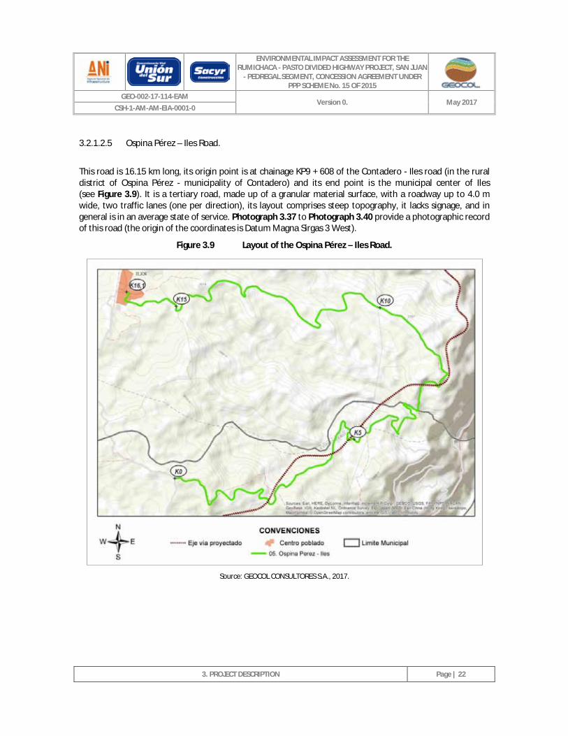
3.2.1.2.5 Ospina Pérez – Iles Road.
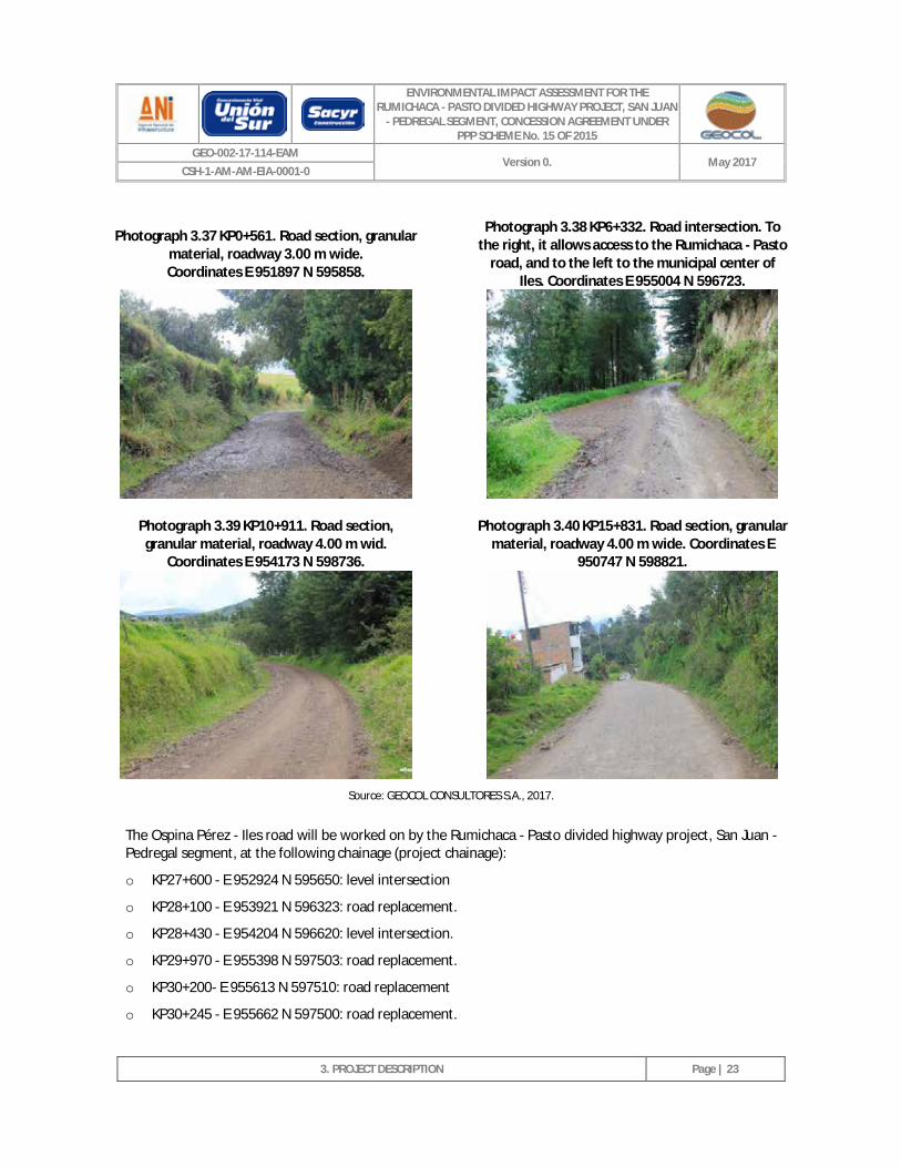
This road is 16.15 km long, its origin point is at chainage KP9 + 608 of the Contadero - Iles road (in the rural district of Ospina Pérez - municipality of Contadero) and its end point is the municipal center of Iles (see Figure 3.9). It is a tertiary road, made up of a granular material surface, with a roadway up to 4.0 m wide, two traffic lanes (one per direction), its layout comprises steep topography, it lacks signage, and in general is in an average state of service. Photograph 3.37 to Photograph 3.40 provide a photographic record of this road (the origin of the coordinates is Datum Magna Sirgas 3 West).
Figure 3.9 Layout of the Ospina Pérez – Iles Road.
Source: GEOCOL CONSULTORES S.A., 2017.
ENVIRONMENTAL IMPACT ASSESSMENT FOR THE RUMICHACA - PASTO DIVIDED HIGHWAY PROJECT, SAN JUAN
- PEDREGAL SEGMENT, CONCESSION AGREEMENT UNDER PPP SCHEME No. 15 OF 2015
GEO-002-17-114-EAM Version 0. May 2017
CSH-1-AM-AM-EIA-0001-0
3. PROJECT DESCRIPTION
Page | 23
Photograph 3.37 KP0+561. Road section, granular material, roadway 3.00 m wide. Coordinates E 951897 N 595858.
Photograph 3.38 KP6+332. Road intersection. To the right, it allows access to the Rumichaca - Pasto
road, and to the left to the municipal center of Iles. Coordinates E 955004 N 596723.
Photograph 3.39 KP10+911. Road section, granular material, roadway 4.00 m wid.
Coordinates E 954173 N 598736.
Photograph 3.40 KP15+831. Road section, granular material, roadway 4.00 m wide. Coordinates E
950747 N 598821.
Source: GEOCOL CONSULTORES S.A., 2017.
The Ospina Pérez - Iles road will be worked on by the Rumichaca - Pasto divided highway project, San Juan - Pedregal segment, at the following chainage (project chainage):
o KP27+600 - E 952924 N 595650: level intersection
o KP28+100 - E 953921 N 596323: road replacement.
o KP28+430 - E 954204 N 596620: level intersection.
o KP29+970 - E 955398 N 597503: road replacement.
o KP30+200- E 955613 N 597510: road replacement
o KP30+245 - E 955662 N 597500: road replacement.
ENVIRONMENTAL IMPACT ASSESSMENT FOR THE RUMICHACA - PASTO DIVIDED HIGHWAY PROJECT, SAN JUAN
- PEDREGAL SEGMENT, CONCESSION AGREEMENT UNDER PPP SCHEME No. 15 OF 2015
GEO-002-17-114-EAM Version 0. May 2017
CSH-1-AM-AM-EIA-0001-0
3. PROJECT DESCRIPTION
Page | 24
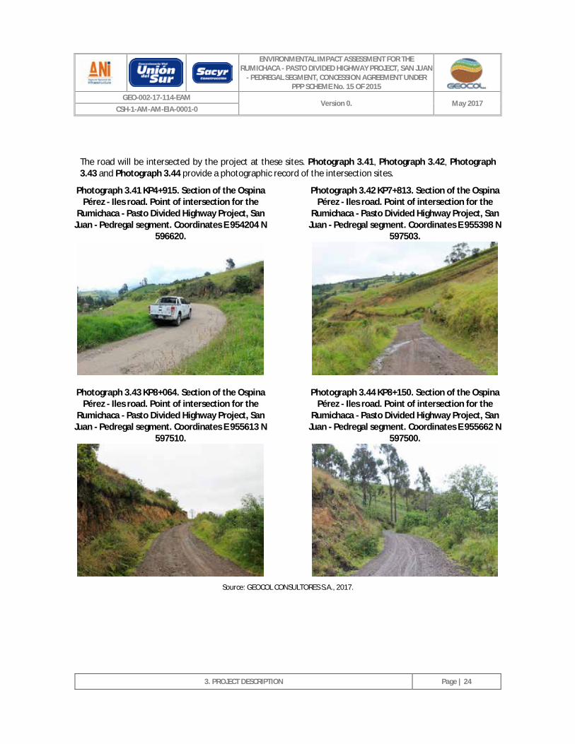
The road will be intersected by the project at these sites. Photograph 3.41, Photograph 3.42, Photograph 3.43 and Photograph 3.44 provide a photographic record of the intersection sites.
Photograph 3.41 KP4+915. Section of the Ospina Pérez - Iles road. Point of intersection for the
Rumichaca - Pasto Divided Highway Project, San Juan - Pedregal segment. Coordinates E 954204 N
596620.
Photograph 3.42 KP7+813. Section of the Ospina Pérez - Iles road. Point of intersection for the
Rumichaca - Pasto Divided Highway Project, San Juan - Pedregal segment. Coordinates E 955398 N
597503.
Photograph 3.43 KP8+064. Section of the Ospina Pérez - Iles road. Point of intersection for the
Rumichaca - Pasto Divided Highway Project, San Juan - Pedregal segment. Coordinates E 955613 N
597510.
Photograph 3.44 KP8+150. Section of the Ospina Pérez - Iles road. Point of intersection for the
Rumichaca - Pasto Divided Highway Project, San Juan - Pedregal segment. Coordinates E 955662 N
597500.
Source: GEOCOL CONSULTORES S.A., 2017.
ENVIRONMENTAL IMPACT ASSESSMENT FOR THE RUMICHACA - PASTO DIVIDED HIGHWAY PROJECT, SAN JUAN
- PEDREGAL SEGMENT, CONCESSION AGREEMENT UNDER PPP SCHEME No. 15 OF 2015
GEO-002-17-114-EAM Version 0. May 2017
CSH-1-AM-AM-EIA-0001-0
3. PROJECT DESCRIPTION
Page | 25
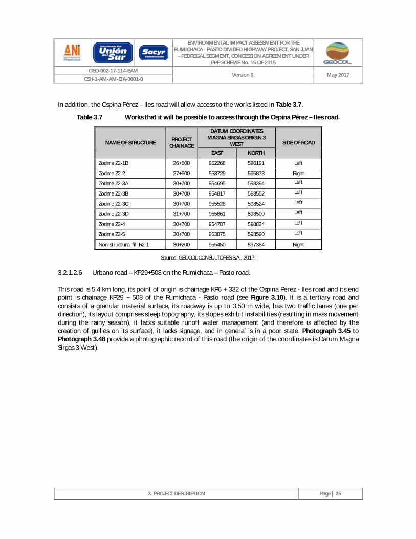
In addition, the Ospina Pérez – Iles road will allow access to the works listed in Table 3.7.
Table 3.7 Works that it will be possible to access through the Ospina Pérez – Iles road.
NAME OF STRUCTURE PROJECT CHAINAGE
DATUM COORDINATES MAGNA SIRGAS ORIGIN 3
WEST SIDE OF ROAD
EAST NORTH
Zodme Z2-1B 26+500 952268 596191 Left
Zodme Z2-2 27+600 953729 595878 Right
Zodme Z2-3A 30+700 954695 598394 Left
Zodme Z2-3B 30+700 954817 598552 Left
Zodme Z2-3C 30+700 955528 598524 Left
Zodme Z2-3D 31+700 955861 598500 Left
Zodme Z2-4 30+700 954787 598824 Left
Zodme Z2-5 30+700 953875 598590 Left
Non-structural fill R2-1 30+200 955450 597384 Right
Source: GEOCOL CONSULTORES S.A., 2017.
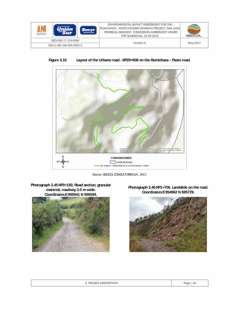
3.2.1.2.6 Urbano road – KP29+508 on the Rumichaca – Pasto road.
This road is 5.4 km long, its point of origin is chainage KP6 + 332 of the Ospina Pérez - Iles road and its end point is chainage KP29 + 508 of the Rumichaca - Pasto road (see Figure 3.10). It is a tertiary road and consists of a granular material surface, its roadway is up to 3.50 m wide, has two traffic lanes (one per direction), its layout comprises steep topography, its slopes exhibit instabilities (resulting in mass movement during the rainy season), it lacks suitable runoff water management (and therefore is affected by the creation of gullies on its surface), it lacks signage, and in general is in a poor state. Photograph 3.45 to Photograph 3.48 provide a photographic record of this road (the origin of the coordinates is Datum Magna Sirgas 3 West).
ENVIRONMENTAL IMPACT ASSESSMENT FOR THE RUMICHACA - PASTO DIVIDED HIGHWAY PROJECT, SAN JUAN
- PEDREGAL SEGMENT, CONCESSION AGREEMENT UNDER PPP SCHEME No. 15 OF 2015
GEO-002-17-114-EAM Version 0. May 2017
CSH-1-AM-AM-EIA-0001-0
3. PROJECT DESCRIPTION
Page | 26
Figure 3.10 Layout of the Urbano road - KP29+508 on the Rumichaca – Pasto road.
Source: GEOCOL CONSULTORES S.A., 2017.
Photograph 3.45 KP0+150. Road section, granular material, roadway 3.0 m wide.
Coordinates E 955041 N 596594. Photograph 3.46 KP1+706. Landslide on the road.
Coordinates E 954962 N 595729.
ENVIRONMENTAL IMPACT ASSESSMENT FOR THE RUMICHACA - PASTO DIVIDED HIGHWAY PROJECT, SAN JUAN
- PEDREGAL SEGMENT, CONCESSION AGREEMENT UNDER PPP SCHEME No. 15 OF 2015
GEO-002-17-114-EAM Version 0. May 2017
CSH-1-AM-AM-EIA-0001-0
3. PROJECT DESCRIPTION
Page | 27
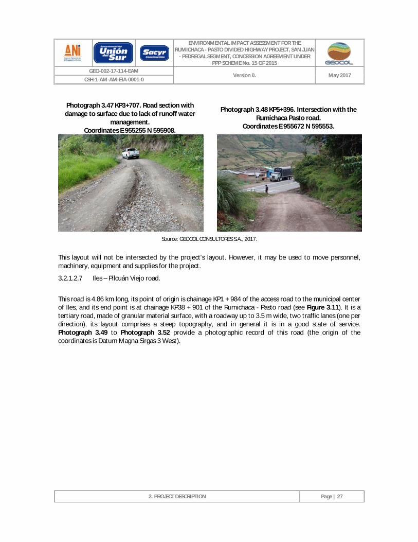
Photograph 3.47 KP3+707. Road section with damage to surface due to lack of runoff water
management. Coordinates E 955255 N 595908.
Photograph 3.48 KP5+396. Intersection with the
Rumichaca Pasto road. Coordinates E 955672 N 595553.
Source: GEOCOL CONSULTORES S.A., 2017.
This layout will not be intersected by the project's layout. However, it may be used to move personnel, machinery, equipment and supplies for the project.
3.2.1.2.7 Iles – Pilcuán Viejo road.
This road is 4.86 km long, its point of origin is chainage KP1 + 984 of the access road to the municipal center of Iles, and its end point is at chainage KP38 + 901 of the Rumichaca - Pasto road (see Figure 3.11). It is a tertiary road, made of granular material surface, with a roadway up to 3.5 m wide, two traffic lanes (one per direction), its layout comprises a steep topography, and in general it is in a good state of service. Photograph 3.49 to Photograph 3.52 provide a photographic record of this road (the origin of the coordinates is Datum Magna Sirgas 3 West).
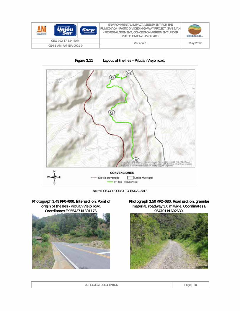
ENVIRONMENTAL IMPACT ASSESSMENT FOR THE RUMICHACA - PASTO DIVIDED HIGHWAY PROJECT, SAN JUAN
- PEDREGAL SEGMENT, CONCESSION AGREEMENT UNDER PPP SCHEME No. 15 OF 2015
GEO-002-17-114-EAM Version 0. May 2017
CSH-1-AM-AM-EIA-0001-0
3. PROJECT DESCRIPTION
Page | 28
Figure 3.11 Layout of the Iles – Pilcuán Viejo road.
Source: GEOCOL CONSULTORES S.A., 2017.
Photograph 3.49 KP0+000. Intersection. Point of origin of the Iles - Pilcuán Viejo road.
Coordinates E 955427 N 601176.
Photograph 3.50 KP2+080. Road section, granular material, roadway 3.0 m wide. Coordinates E
954701 N 602639.
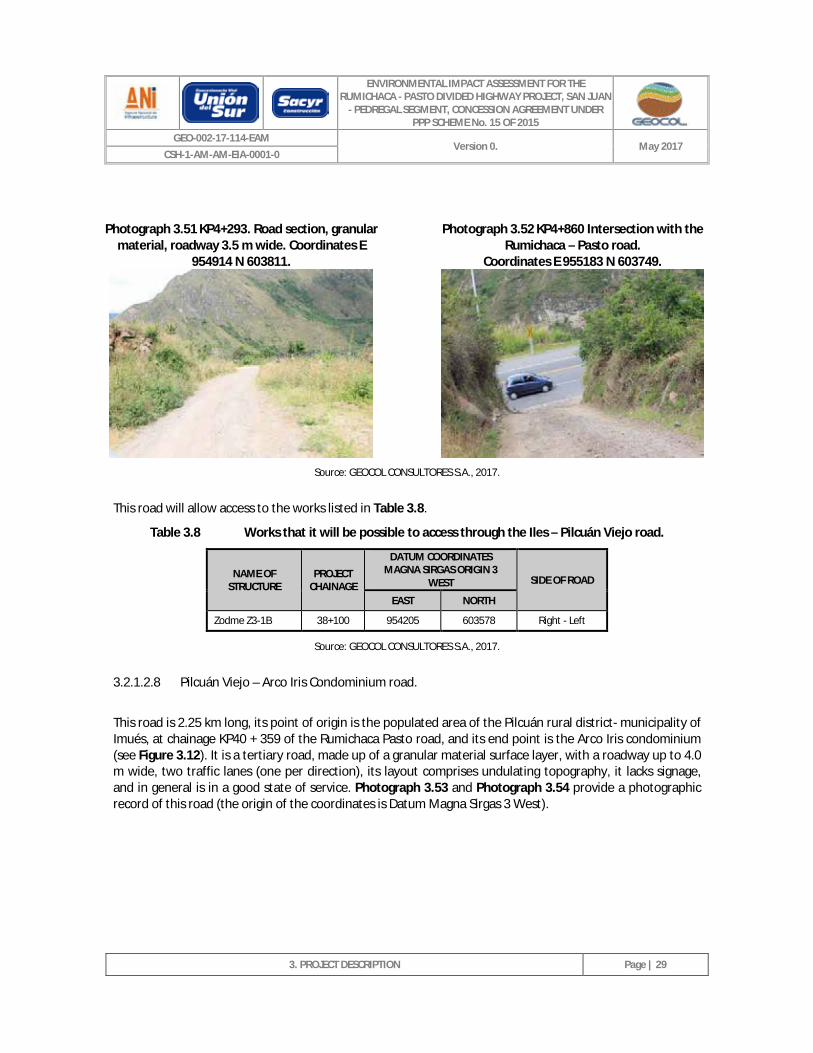
ENVIRONMENTAL IMPACT ASSESSMENT FOR THE RUMICHACA - PASTO DIVIDED HIGHWAY PROJECT, SAN JUAN
- PEDREGAL SEGMENT, CONCESSION AGREEMENT UNDER PPP SCHEME No. 15 OF 2015
GEO-002-17-114-EAM Version 0. May 2017
CSH-1-AM-AM-EIA-0001-0
3. PROJECT DESCRIPTION
Page | 29
Photograph 3.51 KP4+293. Road section, granular
material, roadway 3.5 m wide. Coordinates E 954914 N 603811.
Photograph 3.52 KP4+860 Intersection with the
Rumichaca – Pasto road. Coordinates E 955183 N 603749.
Source: GEOCOL CONSULTORES S.A., 2017.
This road will allow access to the works listed in Table 3.8.
Table 3.8 Works that it will be possible to access through the Iles – Pilcuán Viejo road.
NAME OF STRUCTURE
PROJECT CHAINAGE
DATUM COORDINATES MAGNA SIRGAS ORIGIN 3
WEST SIDE OF ROAD
EAST NORTH
Zodme Z3-1B 38+100 954205 603578 Right - Left
Source: GEOCOL CONSULTORES S.A., 2017.
3.2.1.2.8 Pilcuán Viejo – Arco Iris Condominium road.
This road is 2.25 km long, its point of origin is the populated area of the Pilcuán rural district- municipality of Imués, at chainage KP40 + 359 of the Rumichaca Pasto road, and its end point is the Arco Iris condominium (see Figure 3.12). It is a tertiary road, made up of a granular material surface layer, with a roadway up to 4.0 m wide, two traffic lanes (one per direction), its layout comprises undulating topography, it lacks signage, and in general is in a good state of service. Photograph 3.53 and Photograph 3.54 provide a photographic record of this road (the origin of the coordinates is Datum Magna Sirgas 3 West).
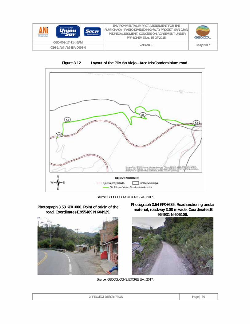
ENVIRONMENTAL IMPACT ASSESSMENT FOR THE RUMICHACA - PASTO DIVIDED HIGHWAY PROJECT, SAN JUAN
- PEDREGAL SEGMENT, CONCESSION AGREEMENT UNDER PPP SCHEME No. 15 OF 2015
GEO-002-17-114-EAM Version 0. May 2017
CSH-1-AM-AM-EIA-0001-0
3. PROJECT DESCRIPTION
Page | 30
Figure 3.12 Layout of the Pilcuán Viejo –Arco Iris Condominium road.
Source: GEOCOL CONSULTORES S.A., 2017.
Photograph 3.53 KP0+000. Point of origin of the road. Coordinates E 955489 N 604929.
Photograph 3.54 KP0+635. Road section, granular material, roadway 3.00 m wide. Coordinates E
954931 N 605106.
Source: GEOCOL CONSULTORES S.A., 2017.
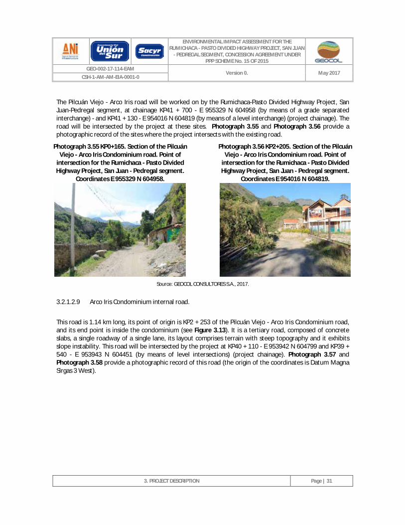
ENVIRONMENTAL IMPACT ASSESSMENT FOR THE RUMICHACA - PASTO DIVIDED HIGHWAY PROJECT, SAN JUAN
- PEDREGAL SEGMENT, CONCESSION AGREEMENT UNDER PPP SCHEME No. 15 OF 2015
GEO-002-17-114-EAM Version 0. May 2017
CSH-1-AM-AM-EIA-0001-0
3. PROJECT DESCRIPTION
Page | 31
The Pilcuán Viejo - Arco Iris road will be worked on by the Rumichaca-Pasto Divided Highway Project, San Juan-Pedregal segment, at chainage KP41 + 700 - E 955329 N 604958 (by means of a grade separated interchange) - and KP41 + 130 - E 954016 N 604819 (by means of a level interchange) (project chainage). The road will be intersected by the project at these sites. Photograph 3.55 and Photograph 3.56 provide a photographic record of the sites where the project intersects with the existing road.
Photograph 3.55 KP0+165. Section of the Pilcuán Viejo - Arco Iris Condominium road. Point of
intersection for the Rumichaca - Pasto Divided Highway Project, San Juan - Pedregal segment.
Coordinates E 955329 N 604958.
Photograph 3.56 KP2+205. Section of the Pilcuán Viejo - Arco Iris Condominium road. Point of
intersection for the Rumichaca - Pasto Divided Highway Project, San Juan - Pedregal segment.
Coordinates E 954016 N 604819.
Source: GEOCOL CONSULTORES S.A., 2017.
3.2.1.2.9 Arco Iris Condominium internal road.
This road is 1.14 km long, its point of origin is KP2 + 253 of the Pilcuán Viejo - Arco Iris Condominium road, and its end point is inside the condominium (see Figure 3.13). It is a tertiary road, composed of concrete slabs, a single roadway of a single lane, its layout comprises terrain with steep topography and it exhibits slope instability. This road will be intersected by the project at KP40 + 110 - E 953942 N 604799 and KP39 + 540 - E 953943 N 604451 (by means of level intersections) (project chainage). Photograph 3.57 and Photograph 3.58 provide a photographic record of this road (the origin of the coordinates is Datum Magna Sirgas 3 West).
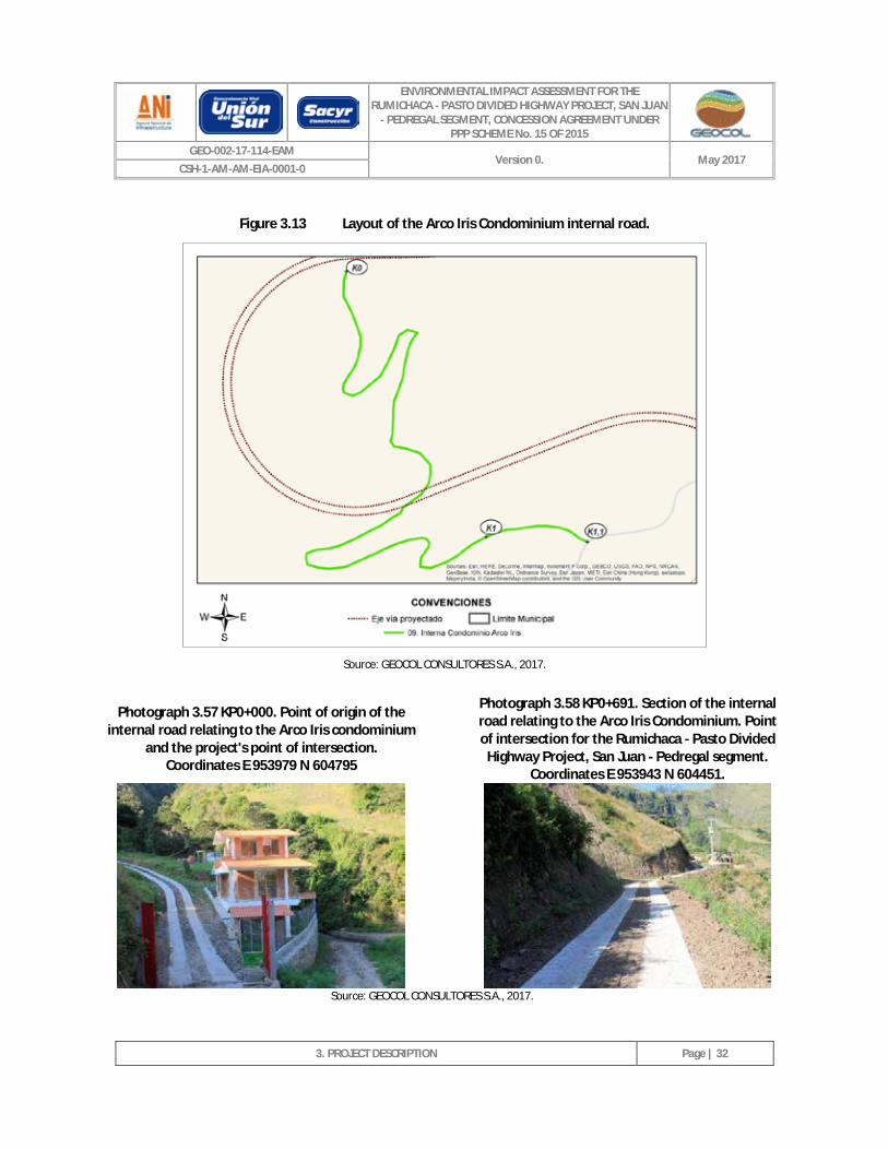
ENVIRONMENTAL IMPACT ASSESSMENT FOR THE RUMICHACA - PASTO DIVIDED HIGHWAY PROJECT, SAN JUAN
- PEDREGAL SEGMENT, CONCESSION AGREEMENT UNDER PPP SCHEME No. 15 OF 2015
GEO-002-17-114-EAM Version 0. May 2017
CSH-1-AM-AM-EIA-0001-0
3. PROJECT DESCRIPTION
Page | 32
Figure 3.13 Layout of the Arco Iris Condominium internal road.
Source: GEOCOL CONSULTORES S.A., 2017.
Photograph 3.57 KP0+000. Point of origin of the internal road relating to the Arco Iris condominium
and the project's point of intersection. Coordinates E 953979 N 604795
Photograph 3.58 KP0+691. Section of the internal road relating to the Arco Iris Condominium. Point of intersection for the Rumichaca - Pasto Divided
Highway Project, San Juan - Pedregal segment. Coordinates E 953943 N 604451.
Source: GEOCOL CONSULTORES S.A., 2017.
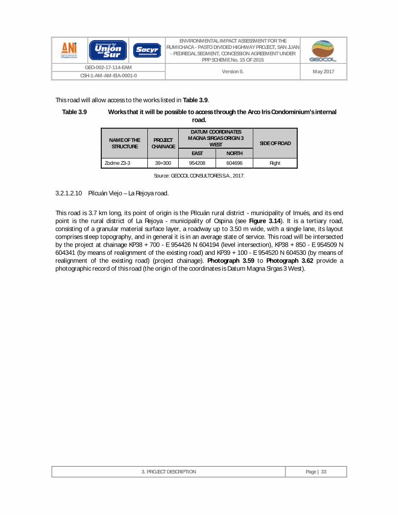
ENVIRONMENTAL IMPACT ASSESSMENT FOR THE RUMICHACA - PASTO DIVIDED HIGHWAY PROJECT, SAN JUAN
- PEDREGAL SEGMENT, CONCESSION AGREEMENT UNDER PPP SCHEME No. 15 OF 2015
GEO-002-17-114-EAM Version 0. May 2017
CSH-1-AM-AM-EIA-0001-0
3. PROJECT DESCRIPTION
Page | 33
This road will allow access to the works listed in Table 3.9.
Table 3.9 Works that it will be possible to access through the Arco Iris Condominium’s internal road.
NAME OF THE STRUCTURE
PROJECT CHAINAGE
DATUM COORDINATES MAGNA SIRGAS ORIGIN 3
WEST SIDE OF ROAD
EAST NORTH
Zodme Z3-3 39+300 954208 604696 Right
Source: GEOCOL CONSULTORES S.A., 2017.
3.2.1.2.10 Pilcuán Viejo – La Rejoya road.
This road is 3.7 km long, its point of origin is the Pilcuán rural district - municipality of Imués, and its end point is the rural district of La Rejoya - municipality of Ospina (see Figure 3.14). It is a tertiary road, consisting of a granular material surface layer, a roadway up to 3.50 m wide, with a single lane, its layout comprises steep topography, and in general it is in an average state of service. This road will be intersected by the project at chainage KP38 + 700 - E 954426 N 604194 (level intersection), KP38 + 850 - E 954509 N 604341 (by means of realignment of the existing road) and KP39 + 100 - E 954520 N 604530 (by means of realignment of the existing road) (project chainage). Photograph 3.59 to Photograph 3.62 provide a photographic record of this road (the origin of the coordinates is Datum Magna Sirgas 3 West).
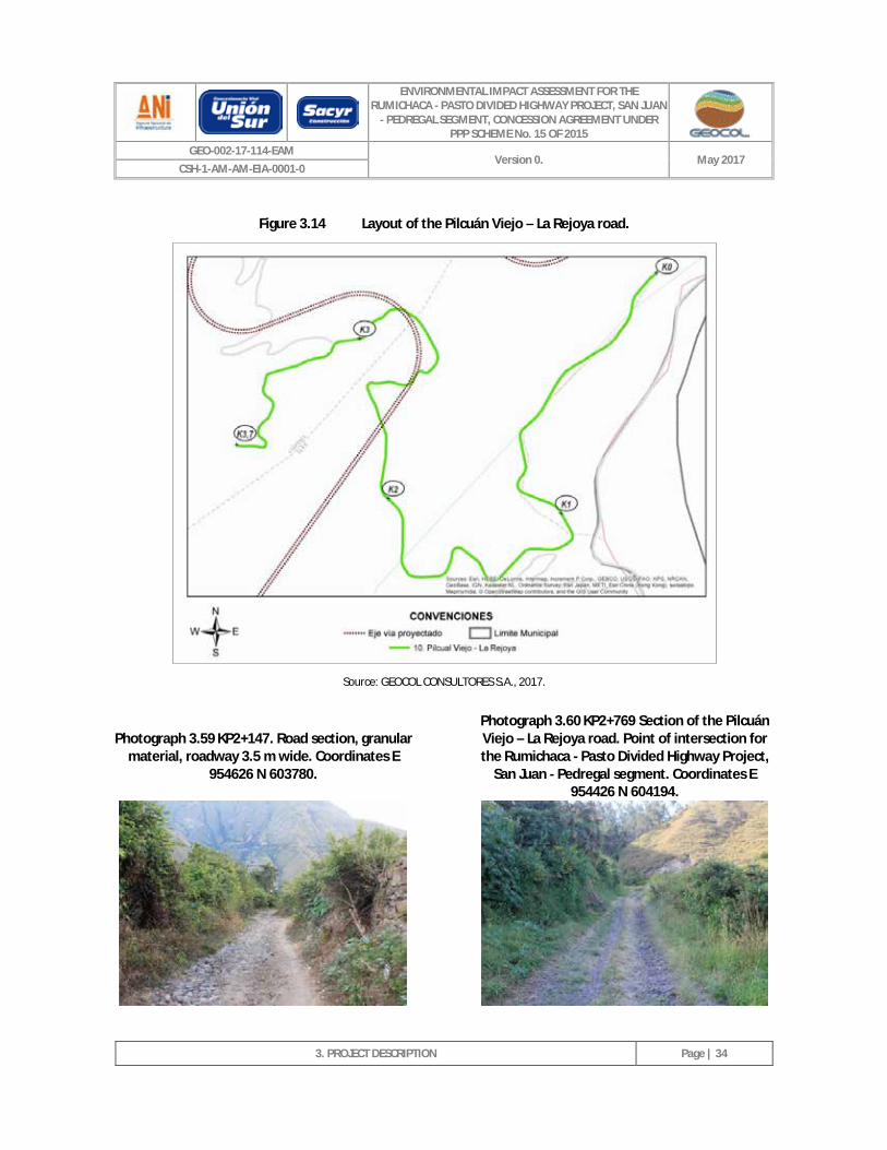
ENVIRONMENTAL IMPACT ASSESSMENT FOR THE RUMICHACA - PASTO DIVIDED HIGHWAY PROJECT, SAN JUAN
- PEDREGAL SEGMENT, CONCESSION AGREEMENT UNDER PPP SCHEME No. 15 OF 2015
GEO-002-17-114-EAM Version 0. May 2017
CSH-1-AM-AM-EIA-0001-0
3. PROJECT DESCRIPTION
Page | 34
Figure 3.14 Layout of the Pilcuán Viejo – La Rejoya road.
Source: GEOCOL CONSULTORES S.A., 2017.
Photograph 3.59 KP2+147. Road section, granular material, roadway 3.5 m wide. Coordinates E
954626 N 603780.
Photograph 3.60 KP2+769 Section of the Pilcuán Viejo – La Rejoya road. Point of intersection for the Rumichaca - Pasto Divided Highway Project,
San Juan - Pedregal segment. Coordinates E 954426 N 604194.
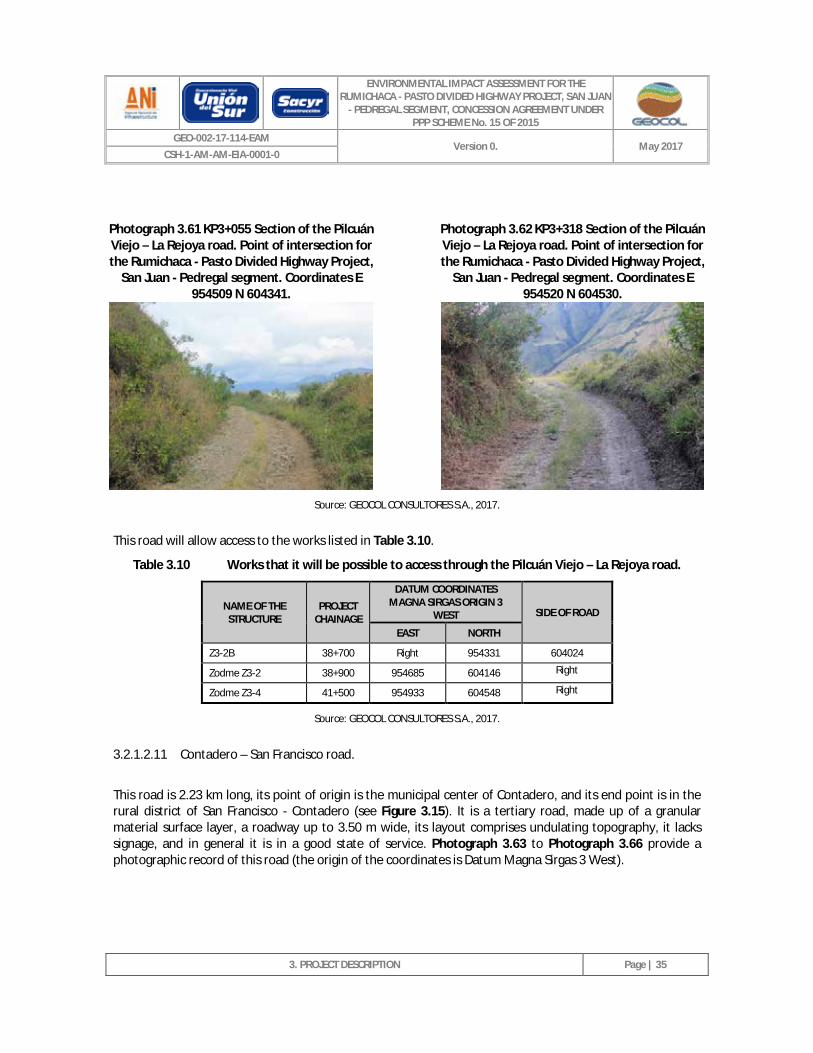
ENVIRONMENTAL IMPACT ASSESSMENT FOR THE RUMICHACA - PASTO DIVIDED HIGHWAY PROJECT, SAN JUAN
- PEDREGAL SEGMENT, CONCESSION AGREEMENT UNDER PPP SCHEME No. 15 OF 2015
GEO-002-17-114-EAM Version 0. May 2017
CSH-1-AM-AM-EIA-0001-0
3. PROJECT DESCRIPTION
Page | 35
Photograph 3.61 KP3+055 Section of the Pilcuán Viejo – La Rejoya road. Point of intersection for the Rumichaca - Pasto Divided Highway Project,
San Juan - Pedregal segment. Coordinates E 954509 N 604341.
Photograph 3.62 KP3+318 Section of the Pilcuán Viejo – La Rejoya road. Point of intersection for the Rumichaca - Pasto Divided Highway Project,
San Juan - Pedregal segment. Coordinates E 954520 N 604530.
Source: GEOCOL CONSULTORES S.A., 2017.
This road will allow access to the works listed in Table 3.10.
Table 3.10 Works that it will be possible to access through the Pilcuán Viejo – La Rejoya road.
NAME OF THE STRUCTURE
PROJECT CHAINAGE
DATUM COORDINATES MAGNA SIRGAS ORIGIN 3
WEST SIDE OF ROAD
EAST NORTH
Z3-2B 38+700 Right 954331 604024
Zodme Z3-2 38+900 954685 604146 Right
Zodme Z3-4 41+500 954933 604548 Right
Source: GEOCOL CONSULTORES S.A., 2017.
3.2.1.2.11 Contadero – San Francisco road.
This road is 2.23 km long, its point of origin is the municipal center of Contadero, and its end point is in the rural district of San Francisco - Contadero (see Figure 3.15). It is a tertiary road, made up of a granular material surface layer, a roadway up to 3.50 m wide, its layout comprises undulating topography, it lacks signage, and in general it is in a good state of service. Photograph 3.63 to Photograph 3.66 provide a photographic record of this road (the origin of the coordinates is Datum Magna Sirgas 3 West).
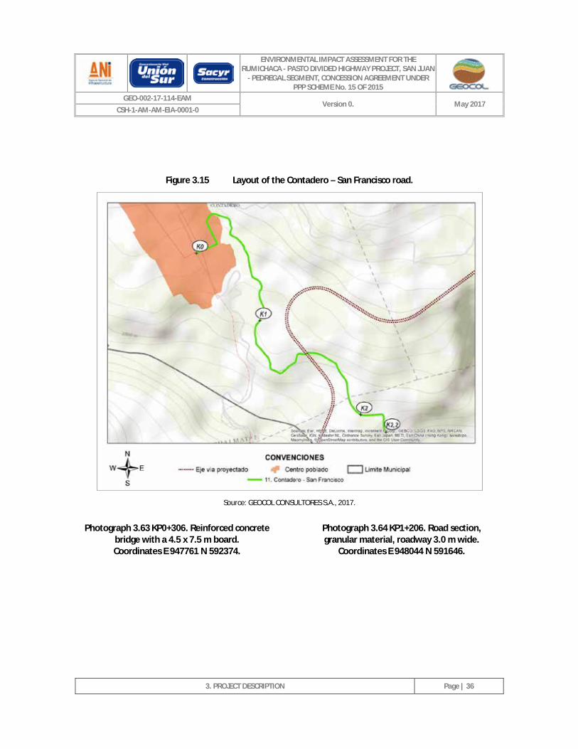
ENVIRONMENTAL IMPACT ASSESSMENT FOR THE RUMICHACA - PASTO DIVIDED HIGHWAY PROJECT, SAN JUAN
- PEDREGAL SEGMENT, CONCESSION AGREEMENT UNDER PPP SCHEME No. 15 OF 2015
GEO-002-17-114-EAM Version 0. May 2017
CSH-1-AM-AM-EIA-0001-0
3. PROJECT DESCRIPTION
Page | 36
Figure 3.15 Layout of the Contadero – San Francisco road.
Source: GEOCOL CONSULTORES S.A., 2017.
Photograph 3.63 KP0+306. Reinforced concrete bridge with a 4.5 x 7.5 m board. Coordinates E 947761 N 592374.
Photograph 3.64 KP1+206. Road section, granular material, roadway 3.0 m wide.
Coordinates E 948044 N 591646.
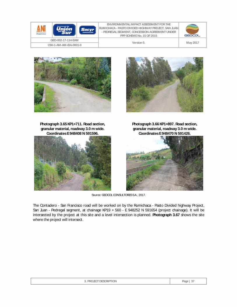
ENVIRONMENTAL IMPACT ASSESSMENT FOR THE RUMICHACA - PASTO DIVIDED HIGHWAY PROJECT, SAN JUAN
- PEDREGAL SEGMENT, CONCESSION AGREEMENT UNDER PPP SCHEME No. 15 OF 2015
GEO-002-17-114-EAM Version 0. May 2017
CSH-1-AM-AM-EIA-0001-0
3. PROJECT DESCRIPTION
Page | 37
Photograph 3.65 KP1+711. Road section, granular material, roadway 3.0 m wide.
Coordinates E 948408 N 591596.
Photograph 3.66 KP1+897. Road section, granular material, roadway 3.0 m wide.
Coordinates E 948470 N 591426.
Source: GEOCOL CONSULTORES S.A., 2017.
The Contadero - San Francisco road will be worked on by the Rumichaca - Pasto Divided highway Project, San Juan - Pedregal segment, at chainage KP19 + 560 - E 948252 N 591654 (project chainage). It will be intersected by the project at this site and a level intersection is planned. Photograph 3.67 shows the site where the project will intersect.
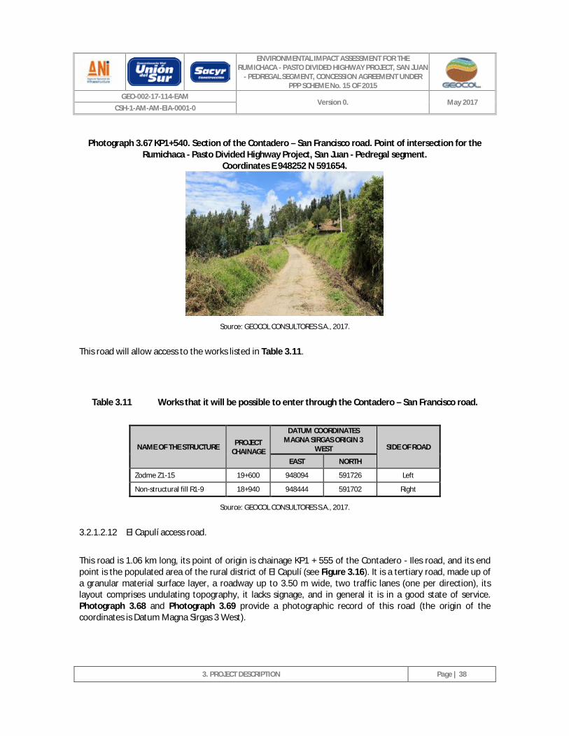
ENVIRONMENTAL IMPACT ASSESSMENT FOR THE RUMICHACA - PASTO DIVIDED HIGHWAY PROJECT, SAN JUAN
- PEDREGAL SEGMENT, CONCESSION AGREEMENT UNDER PPP SCHEME No. 15 OF 2015
GEO-002-17-114-EAM Version 0. May 2017
CSH-1-AM-AM-EIA-0001-0
3. PROJECT DESCRIPTION
Page | 38
Photograph 3.67 KP1+540. Section of the Contadero – San Francisco road. Point of intersection for the Rumichaca - Pasto Divided Highway Project, San Juan - Pedregal segment.
Coordinates E 948252 N 591654.
Source: GEOCOL CONSULTORES S.A., 2017.
This road will allow access to the works listed in Table 3.11.
Table 3.11 Works that it will be possible to enter through the Contadero – San Francisco road.
NAME OF THE STRUCTURE PROJECT CHAINAGE
DATUM COORDINATES MAGNA SIRGAS ORIGIN 3
WEST SIDE OF ROAD
EAST NORTH
Zodme Z1-15 19+600 948094 591726 Left
Non-structural fill R1-9 18+940 948444 591702 Right
Source: GEOCOL CONSULTORES S.A., 2017.
3.2.1.2.12 El Capulí access road.
This road is 1.06 km long, its point of origin is chainage KP1 + 555 of the Contadero - Iles road, and its end point is the populated area of the rural district of El Capulí (see Figure 3.16). It is a tertiary road, made up of a granular material surface layer, a roadway up to 3.50 m wide, two traffic lanes (one per direction), its layout comprises undulating topography, it lacks signage, and in general it is in a good state of service. Photograph 3.68 and Photograph 3.69 provide a photographic record of this road (the origin of the coordinates is Datum Magna Sirgas 3 West).
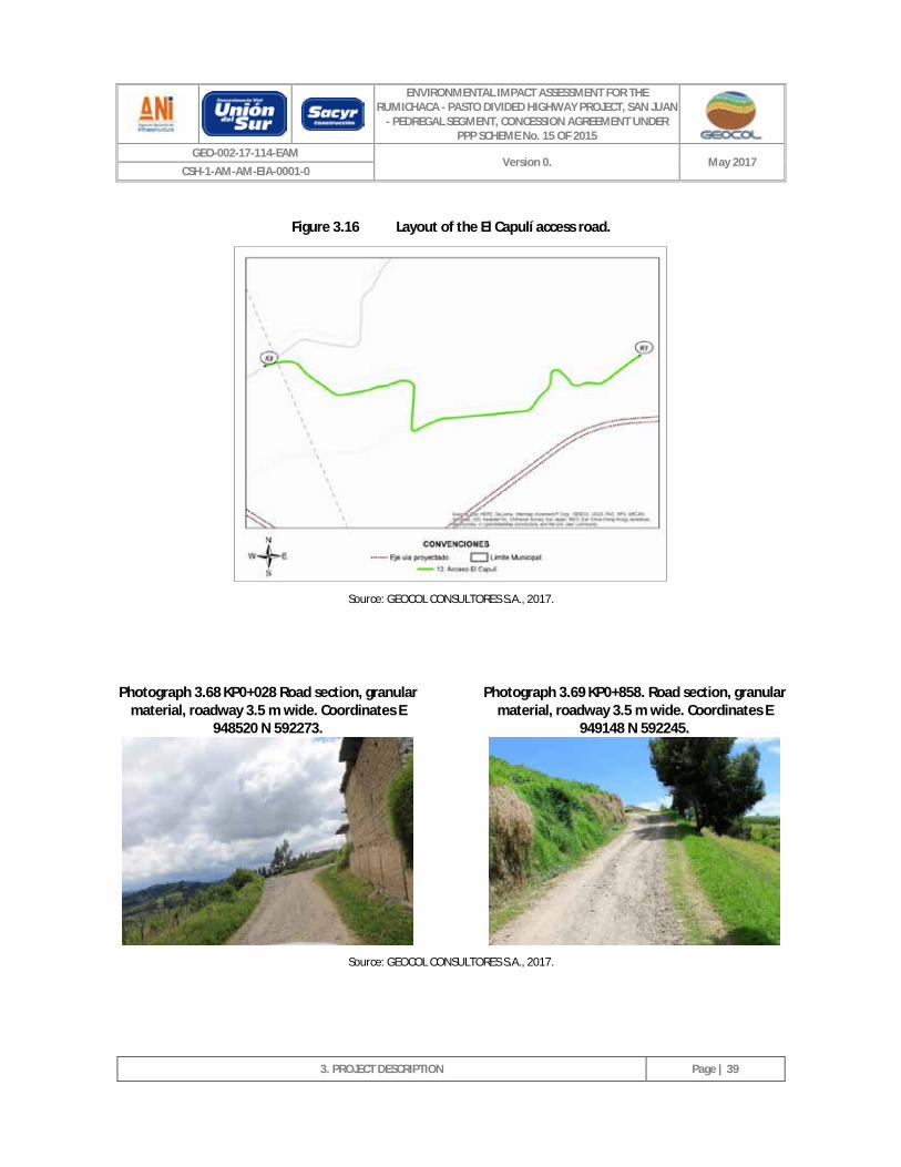
ENVIRONMENTAL IMPACT ASSESSMENT FOR THE RUMICHACA - PASTO DIVIDED HIGHWAY PROJECT, SAN JUAN
- PEDREGAL SEGMENT, CONCESSION AGREEMENT UNDER PPP SCHEME No. 15 OF 2015
GEO-002-17-114-EAM Version 0. May 2017
CSH-1-AM-AM-EIA-0001-0
3. PROJECT DESCRIPTION
Page | 39
Figure 3.16 Layout of the El Capulí access road.
Source: GEOCOL CONSULTORES S.A., 2017.
Photograph 3.68 KP0+028 Road section, granular material, roadway 3.5 m wide. Coordinates E
948520 N 592273.
Photograph 3.69 KP0+858. Road section, granular material, roadway 3.5 m wide. Coordinates E
949148 N 592245.
Source: GEOCOL CONSULTORES S.A., 2017.
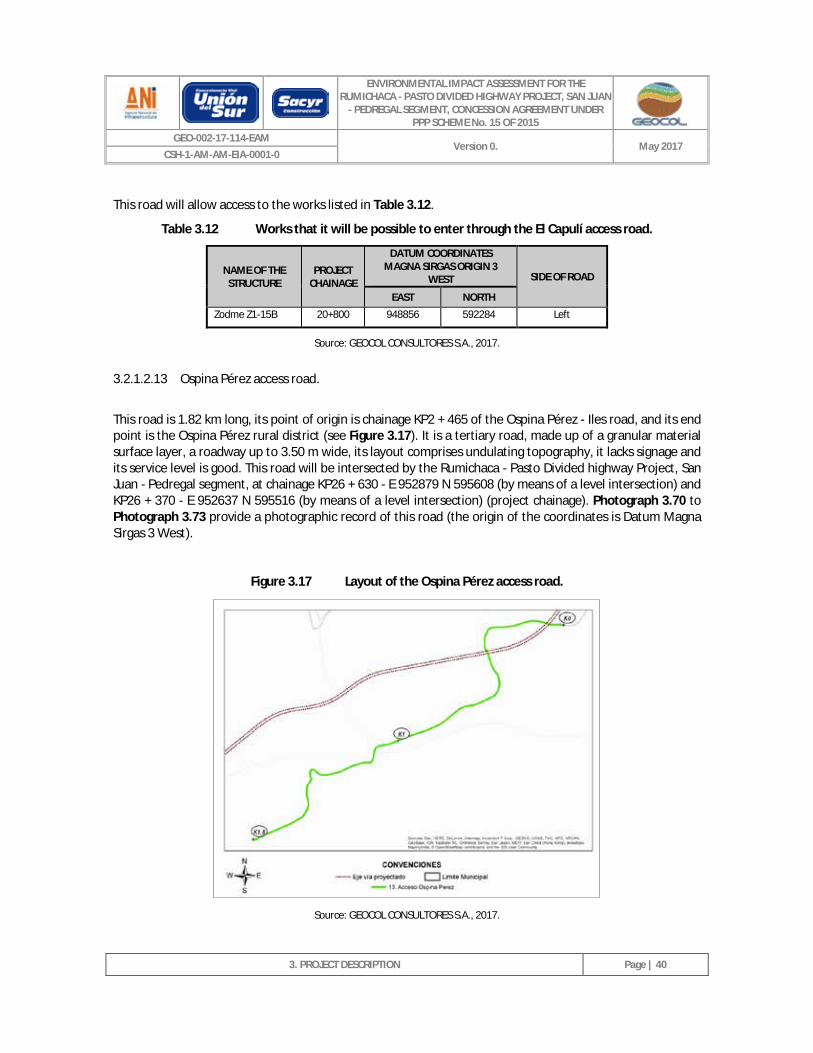
ENVIRONMENTAL IMPACT ASSESSMENT FOR THE RUMICHACA - PASTO DIVIDED HIGHWAY PROJECT, SAN JUAN
- PEDREGAL SEGMENT, CONCESSION AGREEMENT UNDER PPP SCHEME No. 15 OF 2015
GEO-002-17-114-EAM Version 0. May 2017
CSH-1-AM-AM-EIA-0001-0
3. PROJECT DESCRIPTION
Page | 40
This road will allow access to the works listed in Table 3.12.
Table 3.12 Works that it will be possible to enter through the El Capulí access road.
NAME OF THE STRUCTURE
PROJECT CHAINAGE
DATUM COORDINATES MAGNA SIRGAS ORIGIN 3
WEST SIDE OF ROAD
EAST NORTH
Zodme Z1-15B 20+800 948856 592284 Left
Source: GEOCOL CONSULTORES S.A., 2017.
3.2.1.2.13 Ospina Pérez access road.
This road is 1.82 km long, its point of origin is chainage KP2 + 465 of the Ospina Pérez - Iles road, and its end point is the Ospina Pérez rural district (see Figure 3.17). It is a tertiary road, made up of a granular material surface layer, a roadway up to 3.50 m wide, its layout comprises undulating topography, it lacks signage and its service level is good. This road will be intersected by the Rumichaca - Pasto Divided highway Project, San Juan - Pedregal segment, at chainage KP26 + 630 - E 952879 N 595608 (by means of a level intersection) and KP26 + 370 - E 952637 N 595516 (by means of a level intersection) (project chainage). Photograph 3.70 to Photograph 3.73 provide a photographic record of this road (the origin of the coordinates is Datum Magna Sirgas 3 West).
Figure 3.17 Layout of the Ospina Pérez access road.
Source: GEOCOL CONSULTORES S.A., 2017.
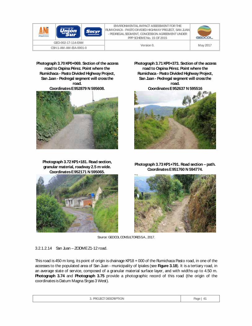
ENVIRONMENTAL IMPACT ASSESSMENT FOR THE RUMICHACA - PASTO DIVIDED HIGHWAY PROJECT, SAN JUAN
- PEDREGAL SEGMENT, CONCESSION AGREEMENT UNDER PPP SCHEME No. 15 OF 2015
GEO-002-17-114-EAM Version 0. May 2017
CSH-1-AM-AM-EIA-0001-0
3. PROJECT DESCRIPTION
Page | 41
Photograph 3.70 KP0+069. Section of the access road to Ospina Pérez. Point where the
Rumichaca - Pasto Divided Highway Project, San Juan - Pedregal segment will cross the
road. Coordinates E 952879 N 595608.
Photograph 3.71 KP0+373. Section of the access road to Ospina Pérez. Point where the
Rumichaca - Pasto Divided Highway Project, San Juan - Pedregal segment will cross the
road. Coordinates E 952637 N 595516
Photograph 3.72 KP1+181. Road section, granular material, roadway 2.5 m wide.
Coordinates E 952171 N 595065. Photograph 3.73 KP1+791. Road section – path.
Coordinates E 951760 N 594774.
Source: GEOCOL CONSULTORES S.A., 2017.
3.2.1.2.14 San Juan – ZODME Z1-12 road.
This road is 450 m long, its point of origin is chainage KP18 + 000 of the Rumichaca Pasto road, in one of the accesses to the populated area of San Juan - municipality of Ipiales (see Figure 3.18). It is a tertiary road, in an average state of service, composed of a granular material surface layer, and with widths up to 4.50 m. Photograph 3.74 and Photograph 3.75 provide a photographic record of this road (the origin of the coordinates is Datum Magna Sirgas 3 West).
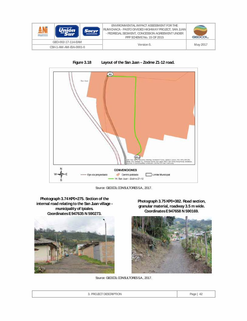
ENVIRONMENTAL IMPACT ASSESSMENT FOR THE RUMICHACA - PASTO DIVIDED HIGHWAY PROJECT, SAN JUAN
- PEDREGAL SEGMENT, CONCESSION AGREEMENT UNDER PPP SCHEME No. 15 OF 2015
GEO-002-17-114-EAM Version 0. May 2017
CSH-1-AM-AM-EIA-0001-0
3. PROJECT DESCRIPTION
Page | 42
Figure 3.18 Layout of the San Juan – Zodme Z1-12 road.
Source: GEOCOL CONSULTORES S.A., 2017.
Photograph 3.74 KP0+275. Section of the internal road relating to the San Juan village -
municipality of Ipiales. Coordinates E 947635 N 590273.
Photograph 3.75 KP0+382. Road section, granular material, roadway 3.5 m wide.
Coordinates E 947658 N 590169.
Source: GEOCOL CONSULTORES S.A., 2017.

ENVIRONMENTAL IMPACT ASSESSMENT FOR THE RUMICHACA - PASTO DIVIDED HIGHWAY PROJECT, SAN JUAN
- PEDREGAL SEGMENT, CONCESSION AGREEMENT UNDER PPP SCHEME No. 15 OF 2015
GEO-002-17-114-EAM Version 0. May 2017
CSH-1-AM-AM-EIA-0001-0
3. PROJECT DESCRIPTION
Page | 43
This road will allow access to the works listed in Table 3.13.
Table 3.13 Works that it will be possible to enter through the San Juan – ZODME Z1-12 road
NAME PROJECT CHAINAGE
DATUM COORDINATES MAGNA SIRGAS ORIGIN 3
WEST SIDE OF ROAD
EAST NORTH
Zodme Z1-12 17+200 947725 590122 Right
Source: GEOCOL CONSULTORES S.A., 2017.
3.2.1.2.15 San Juan – Loma de Suras village road.
This road is 1.43 km long and its point of origin is chainage KP1 + 747 on the San Juan - Contadero road (see Figure 3.19). It is a tertiary road, consisting of a granular material surface layer, a roadway up to 3.50 m wide, two traffic lanes (one per direction), its layout comprises undulating topography, it lacks signage, and it is in a poor state of service. This road will be intersected by the project at KP18 + 180 - E 947725 N 590836 and KP18 + 030 - E 947624 N 590759 (project chainage). Photograph 3.76 and Photograph 3.77 provide a photographic record of this road (the origin of the coordinates is Datum Magna Sirgas 3 West).
Figure 3.19 Layout of the San Juan – Loma de Suras village road.
Source: GEOCOL CONSULTORES S.A., 2017.
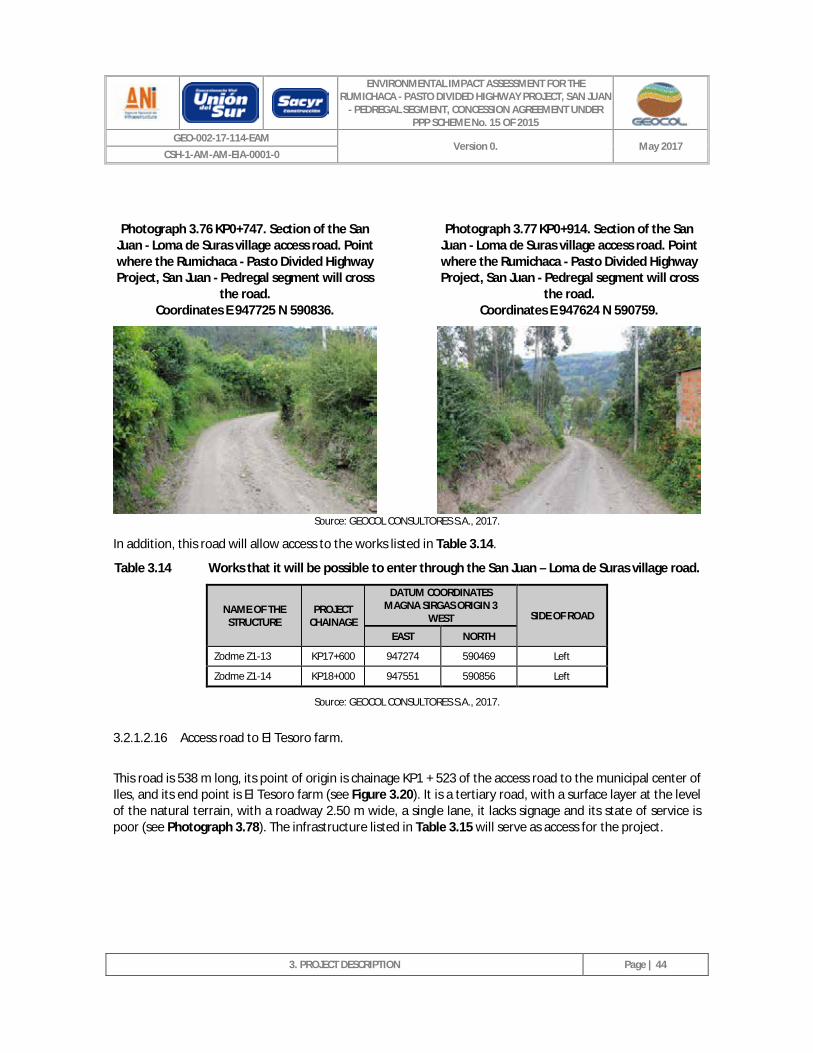
ENVIRONMENTAL IMPACT ASSESSMENT FOR THE RUMICHACA - PASTO DIVIDED HIGHWAY PROJECT, SAN JUAN
- PEDREGAL SEGMENT, CONCESSION AGREEMENT UNDER PPP SCHEME No. 15 OF 2015
GEO-002-17-114-EAM Version 0. May 2017
CSH-1-AM-AM-EIA-0001-0
3. PROJECT DESCRIPTION
Page | 44
Photograph 3.76 KP0+747. Section of the San Juan - Loma de Suras village access road. Point where the Rumichaca - Pasto Divided Highway Project, San Juan - Pedregal segment will cross
the road. Coordinates E 947725 N 590836.
Photograph 3.77 KP0+914. Section of the San Juan - Loma de Suras village access road. Point where the Rumichaca - Pasto Divided Highway Project, San Juan - Pedregal segment will cross
the road. Coordinates E 947624 N 590759.
Source: GEOCOL CONSULTORES S.A., 2017.
In addition, this road will allow access to the works listed in Table 3.14.
Table 3.14 Works that it will be possible to enter through the San Juan – Loma de Suras village road.
NAME OF THE STRUCTURE
PROJECT CHAINAGE
DATUM COORDINATES MAGNA SIRGAS ORIGIN 3
WEST SIDE OF ROAD
EAST NORTH
Zodme Z1-13 KP17+600 947274 590469 Left
Zodme Z1-14 KP18+000 947551 590856 Left
Source: GEOCOL CONSULTORES S.A., 2017.
3.2.1.2.16 Access road to El Tesoro farm.
This road is 538 m long, its point of origin is chainage KP1 + 523 of the access road to the municipal center of Iles, and its end point is El Tesoro farm (see Figure 3.20). It is a tertiary road, with a surface layer at the level of the natural terrain, with a roadway 2.50 m wide, a single lane, it lacks signage and its state of service is poor (see Photograph 3.78). The infrastructure listed in Table 3.15 will serve as access for the project.
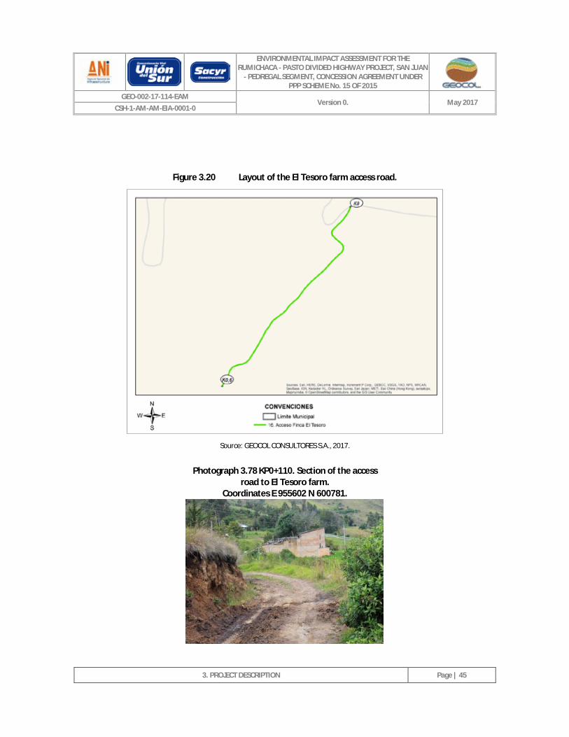
ENVIRONMENTAL IMPACT ASSESSMENT FOR THE RUMICHACA - PASTO DIVIDED HIGHWAY PROJECT, SAN JUAN
- PEDREGAL SEGMENT, CONCESSION AGREEMENT UNDER PPP SCHEME No. 15 OF 2015
GEO-002-17-114-EAM Version 0. May 2017
CSH-1-AM-AM-EIA-0001-0
3. PROJECT DESCRIPTION
Page | 45
Figure 3.20 Layout of the El Tesoro farm access road.
Source: GEOCOL CONSULTORES S.A., 2017.
Photograph 3.78 KP0+110. Section of the access road to El Tesoro farm.
Coordinates E 955602 N 600781.
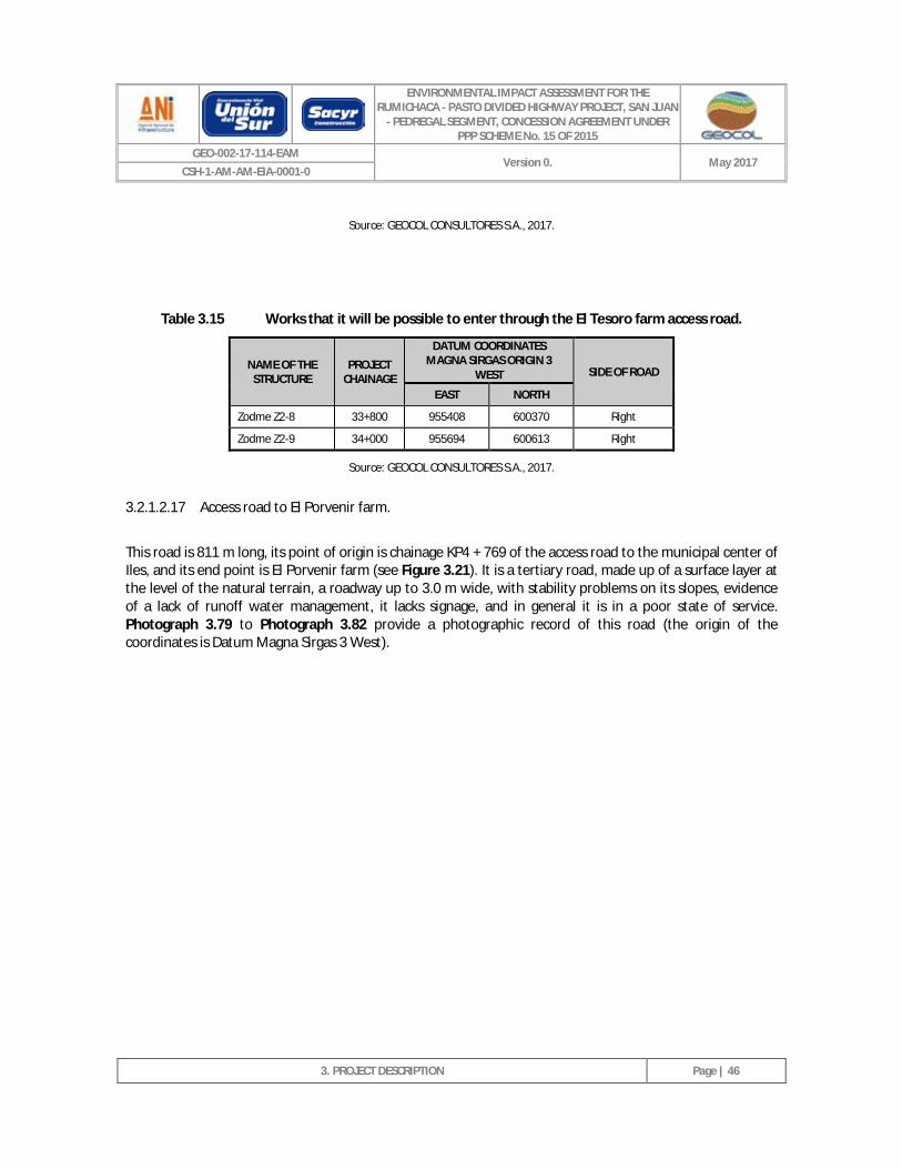
ENVIRONMENTAL IMPACT ASSESSMENT FOR THE RUMICHACA - PASTO DIVIDED HIGHWAY PROJECT, SAN JUAN
- PEDREGAL SEGMENT, CONCESSION AGREEMENT UNDER PPP SCHEME No. 15 OF 2015
GEO-002-17-114-EAM Version 0. May 2017
CSH-1-AM-AM-EIA-0001-0
3. PROJECT DESCRIPTION
Page | 46
Source: GEOCOL CONSULTORES S.A., 2017.
Table 3.15 Works that it will be possible to enter through the El Tesoro farm access road.
NAME OF THE STRUCTURE
PROJECT CHAINAGE
DATUM COORDINATES MAGNA SIRGAS ORIGIN 3
WEST SIDE OF ROAD
EAST NORTH
Zodme Z2-8 33+800 955408 600370 Right
Zodme Z2-9 34+000 955694 600613 Right
Source: GEOCOL CONSULTORES S.A., 2017.
3.2.1.2.17 Access road to El Porvenir farm.
This road is 811 m long, its point of origin is chainage KP4 + 769 of the access road to the municipal center of Iles, and its end point is El Porvenir farm (see Figure 3.21). It is a tertiary road, made up of a surface layer at the level of the natural terrain, a roadway up to 3.0 m wide, with stability problems on its slopes, evidence of a lack of runoff water management, it lacks signage, and in general it is in a poor state of service. Photograph 3.79 to Photograph 3.82 provide a photographic record of this road (the origin of the coordinates is Datum Magna Sirgas 3 West).
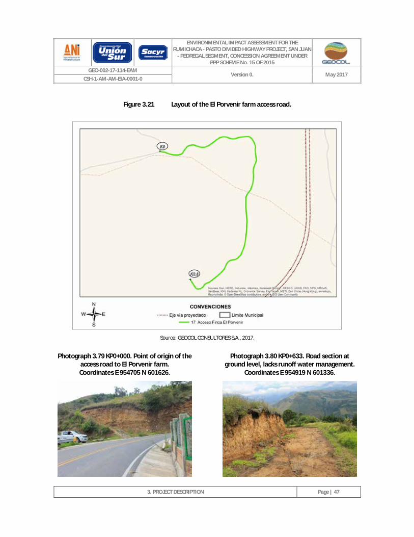
ENVIRONMENTAL IMPACT ASSESSMENT FOR THE RUMICHACA - PASTO DIVIDED HIGHWAY PROJECT, SAN JUAN
- PEDREGAL SEGMENT, CONCESSION AGREEMENT UNDER PPP SCHEME No. 15 OF 2015
GEO-002-17-114-EAM Version 0. May 2017
CSH-1-AM-AM-EIA-0001-0
3. PROJECT DESCRIPTION
Page | 47
Figure 3.21 Layout of the El Porvenir farm access road.
Source: GEOCOL CONSULTORES S.A., 2017.
Photograph 3.79 KP0+000. Point of origin of the access road to El Porvenir farm. Coordinates E 954705 N 601626.
Photograph 3.80 KP0+633. Road section at
ground level, lacks runoff water management. Coordinates E 954919 N 601336.
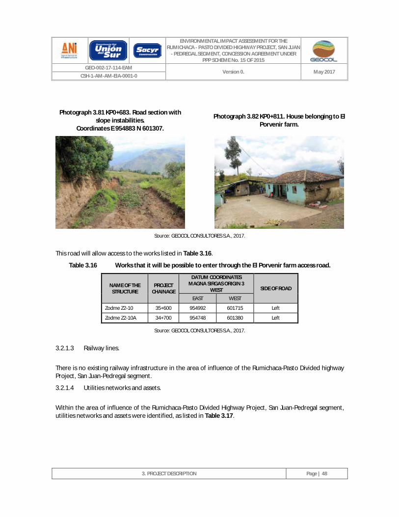
ENVIRONMENTAL IMPACT ASSESSMENT FOR THE RUMICHACA - PASTO DIVIDED HIGHWAY PROJECT, SAN JUAN
- PEDREGAL SEGMENT, CONCESSION AGREEMENT UNDER PPP SCHEME No. 15 OF 2015
GEO-002-17-114-EAM Version 0. May 2017
CSH-1-AM-AM-EIA-0001-0
3. PROJECT DESCRIPTION
Page | 48
Photograph 3.81 KP0+683. Road section with slope instabilities.
Coordinates E 954883 N 601307. Photograph 3.82 KP0+811. House belonging to El
Porvenir farm.
Source: GEOCOL CONSULTORES S.A., 2017.
This road will allow access to the works listed in Table 3.16.
Table 3.16 Works that it will be possible to enter through the El Porvenir farm access road.
NAME OF THE STRUCTURE
PROJECT CHAINAGE
DATUM COORDINATES MAGNA SIRGAS ORIGIN 3
WEST SIDE OF ROAD
EAST WEST
Zodme Z2-10 35+600 954992 601715 Left
Zodme Z2-10A 34+700 954748 601380 Left
Source: GEOCOL CONSULTORES S.A., 2017.
3.2.1.3 Railway lines.
There is no existing railway infrastructure in the area of influence of the Rumichaca-Pasto Divided highway Project, San Juan-Pedregal segment.
3.2.1.4 Utilities networks and assets.
Within the area of influence of the Rumichaca-Pasto Divided Highway Project, San Juan-Pedregal segment, utilities networks and assets were identified, as listed in Table 3.17.
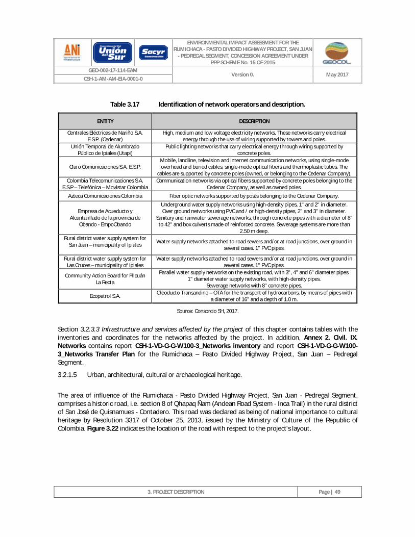
ENVIRONMENTAL IMPACT ASSESSMENT FOR THE RUMICHACA - PASTO DIVIDED HIGHWAY PROJECT, SAN JUAN
- PEDREGAL SEGMENT, CONCESSION AGREEMENT UNDER PPP SCHEME No. 15 OF 2015
GEO-002-17-114-EAM Version 0. May 2017
CSH-1-AM-AM-EIA-0001-0
3. PROJECT DESCRIPTION
Page | 49
Table 3.17 Identification of network operators and description.
ENTITY DESCRIPTION
Centrales Eléctricas de Nariño S.A. E.S.P. (Cedenar)
High, medium and low voltage electricity networks. These networks carry electrical energy through the use of wiring supported by towers and poles.
Unión Temporal de Alumbrado Público de Ipiales (Utapi)
Public lighting networks that carry electrical energy through wiring supported by concrete poles.
Claro Comunicaciones S.A. E.S.P. Mobile, landline, television and internet communication networks, using single-mode overhead and buried cables, single-mode optical fibers and thermoplastic tubes. The
cables are supported by concrete poles (owned, or belonging to the Cedenar Company). Colombia Telecomunicaciones S.A.
E.S.P – Telefónica – Movistar Colombia Communication networks via optical fibers supported by concrete poles belonging to the
Cedenar Company, as well as owned poles.
Azteca Comunicaciones Colombia Fiber optic networks supported by posts belonging to the Cedenar Company.
Empresa de Acueducto y Alcantarillado de la provincia de
Obando - EmpoObando
Underground water supply networks using high-density pipes, 1" and 2" in diameter. Over ground networks using PVC and / or high-density pipes, 2" and 3" in diameter.
Sanitary and rainwater sewerage networks, through concrete pipes with a diameter of 8" to 42" and box culverts made of reinforced concrete. Sewerage systems are more than
2.50 m deep. Rural district water supply system for
San Juan – municipality of Ipiales
Water supply networks attached to road sewers and/or at road junctions, over ground in several cases. 1" PVC pipes.
Rural district water supply system for Las Cruces – municipality of Ipiales
Water supply networks attached to road sewers and/or at road junctions, over ground in several cases. 1" PVC pipes.
Community Action Board for Pilcuán La Recta
Parallel water supply networks on the existing road, with 3", 4" and 6" diameter pipes. 1" diameter water supply networks, with high-density pipes.
Sewerage networks with 8" concrete pipes.
Ecopetrol S.A. Oleoducto Transandino – OTA for the transport of hydrocarbons, by means of pipes with a diameter of 16" and a depth of 1.0 m.
Source: Consorcio SH, 2017.
Section 3.2.3.3 Infrastructure and services affected by the project of this chapter contains tables with the inventories and coordinates for the networks affected by the project. In addition, Annex 2. Civil. IX. Networks contains report CSH-1-VD-G-G-W100-3_Networks inventory and report CSH-1-VD-G-G-W100-3_Networks Transfer Plan for the Rumichaca – Pasto Divided Highway Project, San Juan – Pedregal Segment.
3.2.1.5 Urban, architectural, cultural or archaeological heritage.
The area of influence of the Rumichaca - Pasto Divided Highway Project, San Juan - Pedregal Segment, comprises a historic road, i.e. section 8 of Qhapaq Ñam (Andean Road System - Inca Trail) in the rural district of San José de Quisnamues - Contadero. This road was declared as being of national importance to cultural heritage by Resolution 3317 of October 25, 2013, issued by the Ministry of Culture of the Republic of Colombia. Figure 3.22 indicates the location of the road with respect to the project's layout.
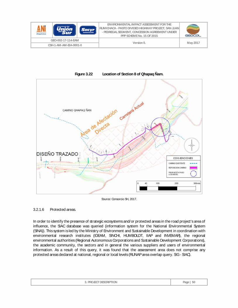
ENVIRONMENTAL IMPACT ASSESSMENT FOR THE RUMICHACA - PASTO DIVIDED HIGHWAY PROJECT, SAN JUAN
- PEDREGAL SEGMENT, CONCESSION AGREEMENT UNDER PPP SCHEME No. 15 OF 2015
GEO-002-17-114-EAM Version 0. May 2017
CSH-1-AM-AM-EIA-0001-0
3. PROJECT DESCRIPTION
Page | 50
Figure 3.22 Location of Section 8 of Qhapaq Ñam.
Source: Consorcio SH, 2017.
3.2.1.6 Protected areas.
In order to identify the presence of strategic ecosystems and/or protected areas in the road project's area of influence, the SIAC database was queried (information system for the National Environmental System (SINA)). This system is led by the Ministry of Environment and Sustainable Development in coordination with environmental research institutes (IDEAM, SINCHI, HUMBOLDT, IIAP and INVEMAR), the regional environmental authorities (Regional Autonomous Corporations and Sustainable Development Corporations), the academic community, the sectors and in general the various suppliers and users of environmental information. As a result of this query, it was found that the assessment area does not comprise any protected areas declared at national, regional or local levels (RUNAP area overlap query. SIG - SIAC).
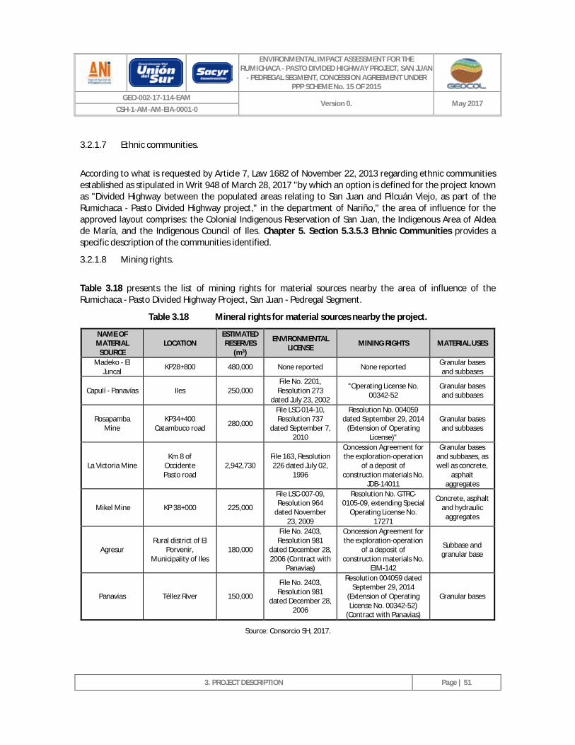
ENVIRONMENTAL IMPACT ASSESSMENT FOR THE RUMICHACA - PASTO DIVIDED HIGHWAY PROJECT, SAN JUAN
- PEDREGAL SEGMENT, CONCESSION AGREEMENT UNDER PPP SCHEME No. 15 OF 2015
GEO-002-17-114-EAM Version 0. May 2017
CSH-1-AM-AM-EIA-0001-0
3. PROJECT DESCRIPTION
Page | 51
3.2.1.7 Ethnic communities.
According to what is requested by Article 7, Law 1682 of November 22, 2013 regarding ethnic communities established as stipulated in Writ 948 of March 28, 2017 "by which an option is defined for the project known as "Divided Highway between the populated areas relating to San Juan and Pilcuán Viejo, as part of the Rumichaca - Pasto Divided Highway project," in the department of Nariño," the area of influence for the approved layout comprises: the Colonial Indigenous Reservation of San Juan, the Indigenous Area of Aldea de María, and the Indigenous Council of Iles. Chapter 5. Section 5.3.5.3 Ethnic Communities provides a specific description of the communities identified.
3.2.1.8 Mining rights.
Table 3.18 presents the list of mining rights for material sources nearby the area of influence of the Rumichaca - Pasto Divided Highway Project, San Juan - Pedregal Segment.
Table 3.18 Mineral rights for material sources nearby the project.
NAME OF MATERIAL
SOURCE LOCATION
ESTIMATED RESERVES
(m3)
ENVIRONMENTAL LICENSE MINING RIGHTS MATERIAL USES
Madeko - El Juncal KP28+800 480,000 None reported None reported Granular bases
and subbases
Capulí - Panavías Iles 250,000 File No. 2201,
Resolution 273 dated July 23, 2002
"Operating License No. 00342-52
Granular bases and subbases
Rosapamba Mine
KP34+400 Catambuco road 280,000
File LSC-014-10, Resolution 737
dated September 7, 2010
Resolution No. 004059 dated September 29, 2014
(Extension of Operating License)"
Granular bases and subbases
La Victoria Mine Km 8 of
Occidente Pasto road
2,942,730 File 163, Resolution 226 dated July 02,
1996
Concession Agreement for the exploration-operation
of a deposit of construction materials No.
JDB-14011
Granular bases and subbases, as well as concrete,
asphalt aggregates
Mikel Mine KP 38+000 225,000
File LSC-007-09, Resolution 964
dated November 23, 2009
Resolution No. GTRC-0105-09, extending Special
Operating License No. 17271
Concrete, asphalt and hydraulic
aggregates
Agresur Rural district of El
Porvenir, Municipality of Iles
180,000
File No. 2403, Resolution 981
dated December 28, 2006 (Contract with
Panavias)
Concession Agreement for the exploration-operation
of a deposit of construction materials No.
EIM-142
Subbase and granular base
Panavias Téllez River 150,000
File No. 2403, Resolution 981
dated December 28, 2006
Resolution 004059 dated September 29, 2014
(Extension of Operating License No. 00342-52)
(Contract with Panavias)
Granular bases
Source: Consorcio SH, 2017.
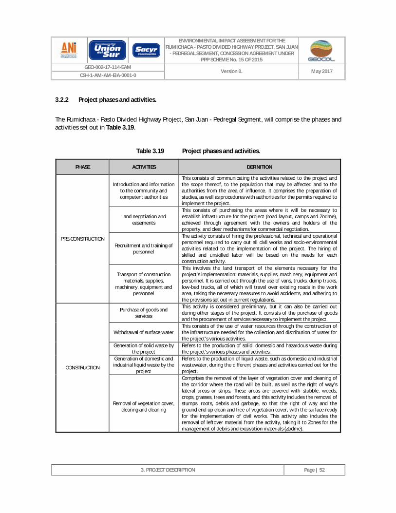
ENVIRONMENTAL IMPACT ASSESSMENT FOR THE RUMICHACA - PASTO DIVIDED HIGHWAY PROJECT, SAN JUAN
- PEDREGAL SEGMENT, CONCESSION AGREEMENT UNDER PPP SCHEME No. 15 OF 2015
GEO-002-17-114-EAM Version 0. May 2017
CSH-1-AM-AM-EIA-0001-0
3. PROJECT DESCRIPTION
Page | 52
3.2.2 Project phases and activities.
The Rumichaca - Pasto Divided Highway Project, San Juan - Pedregal Segment, will comprise the phases and activities set out in Table 3.19.
Table 3.19 Project phases and activities.
PHASE ACTIVITIES DEFINITION
PRE-CONSTRUCTION
Introduction and information to the community and competent authorities
This consists of communicating the activities related to the project and the scope thereof, to the population that may be affected and to the authorities from the area of influence. It comprises the preparation of studies, as well as procedures with authorities for the permits required to implement the project.
Land negotiation and easements
This consists of purchasing the areas where it will be necessary to establish infrastructure for the project (road layout, camps and Zodme), achieved through agreement with the owners and holders of the property, and clear mechanisms for commercial negotiation.
Recruitment and training of personnel
The activity consists of hiring the professional, technical and operational personnel required to carry out all civil works and socio-environmental activities related to the implementation of the project. The hiring of skilled and unskilled labor will be based on the needs for each construction activity.
Transport of construction materials, supplies,
machinery, equipment and personnel
This involves the land transport of the elements necessary for the project's implementation: materials, supplies, machinery, equipment and personnel. It is carried out through the use of vans, trucks, dump trucks, low-bed trucks, all of which will travel over existing roads in the work area, taking the necessary measures to avoid accidents, and adhering to the provisions set out in current regulations.
CONSTRUCTION
Purchase of goods and services
This activity is considered preliminary, but it can also be carried out during other stages of the project. It consists of the purchase of goods and the procurement of services necessary to implement the project.
Withdrawal of surface water This consists of the use of water resources through the construction of the infrastructure needed for the collection and distribution of water for the project's various activities.
Generation of solid waste by the project
Refers to the production of solid, domestic and hazardous waste during the project's various phases and activities.
Generation of domestic and industrial liquid waste by the
project
Refers to the production of liquid waste, such as domestic and industrial wastewater, during the different phases and activities carried out for the project.
Removal of vegetation cover,
clearing and cleaning
Comprises the removal of the layer of vegetation cover and cleaning of the corridor where the road will be built, as well as the right of way’s lateral areas or strips. These areas are covered with stubble, weeds, crops, grasses, trees and forests, and this activity includes the removal of stumps, roots, debris and garbage, so that the right of way and the ground end up clean and free of vegetation cover, with the surface ready for the implementation of civil works. This activity also includes the removal of leftover material from the activity, taking it to Zones for the management of debris and excavation materials (Zodme).
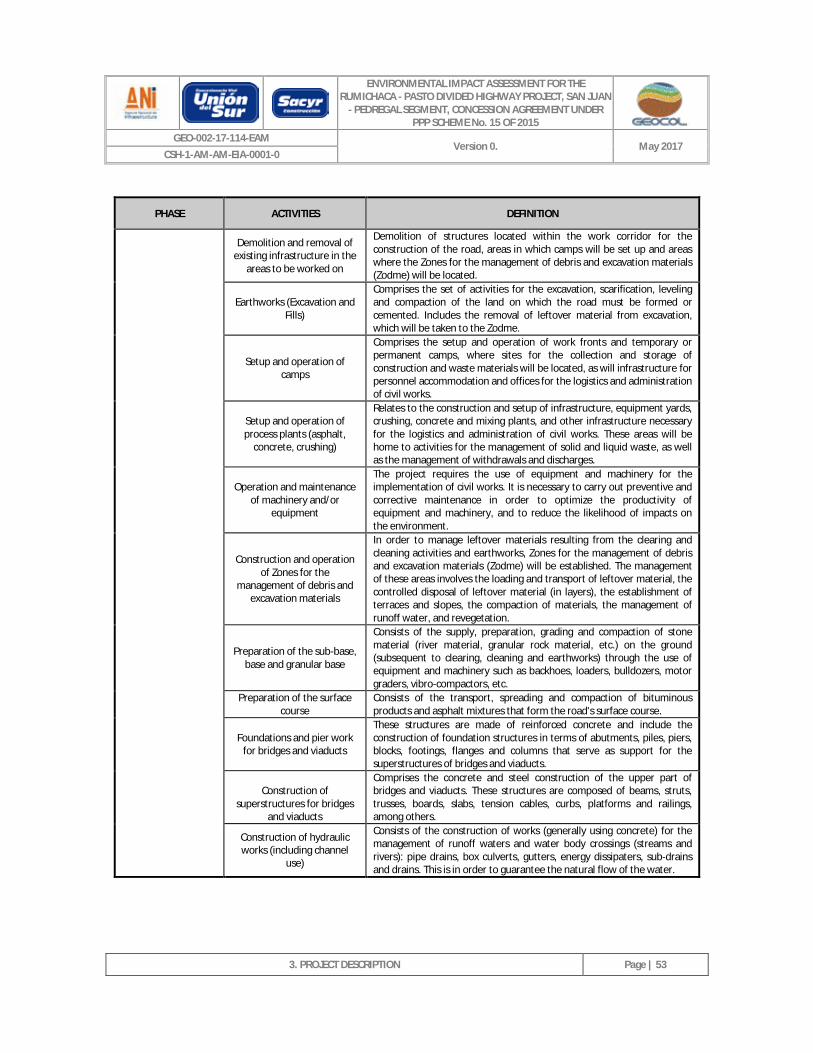
ENVIRONMENTAL IMPACT ASSESSMENT FOR THE RUMICHACA - PASTO DIVIDED HIGHWAY PROJECT, SAN JUAN
- PEDREGAL SEGMENT, CONCESSION AGREEMENT UNDER PPP SCHEME No. 15 OF 2015
GEO-002-17-114-EAM Version 0. May 2017
CSH-1-AM-AM-EIA-0001-0
3. PROJECT DESCRIPTION
Page | 53
PHASE ACTIVITIES DEFINITION
Demolition and removal of existing infrastructure in the
areas to be worked on
Demolition of structures located within the work corridor for the construction of the road, areas in which camps will be set up and areas where the Zones for the management of debris and excavation materials (Zodme) will be located.
Earthworks (Excavation and Fills)
Comprises the set of activities for the excavation, scarification, leveling and compaction of the land on which the road must be formed or cemented. Includes the removal of leftover material from excavation, which will be taken to the Zodme.
Setup and operation of camps
Comprises the setup and operation of work fronts and temporary or permanent camps, where sites for the collection and storage of construction and waste materials will be located, as will infrastructure for personnel accommodation and offices for the logistics and administration of civil works.
Setup and operation of process plants (asphalt,
concrete, crushing)
Relates to the construction and setup of infrastructure, equipment yards, crushing, concrete and mixing plants, and other infrastructure necessary for the logistics and administration of civil works. These areas will be home to activities for the management of solid and liquid waste, as well as the management of withdrawals and discharges.
Operation and maintenance of machinery and/or
equipment
The project requires the use of equipment and machinery for the implementation of civil works. It is necessary to carry out preventive and corrective maintenance in order to optimize the productivity of equipment and machinery, and to reduce the likelihood of impacts on the environment.
Construction and operation of Zones for the
management of debris and excavation materials
In order to manage leftover materials resulting from the clearing and cleaning activities and earthworks, Zones for the management of debris and excavation materials (Zodme) will be established. The management of these areas involves the loading and transport of leftover material, the controlled disposal of leftover material (in layers), the establishment of terraces and slopes, the compaction of materials, the management of runoff water, and revegetation.
Preparation of the sub-base, base and granular base
Consists of the supply, preparation, grading and compaction of stone material (river material, granular rock material, etc.) on the ground (subsequent to clearing, cleaning and earthworks) through the use of equipment and machinery such as backhoes, loaders, bulldozers, motor graders, vibro-compactors, etc.
Preparation of the surface course
Consists of the transport, spreading and compaction of bituminous products and asphalt mixtures that form the road's surface course.
Foundations and pier work for bridges and viaducts
These structures are made of reinforced concrete and include the construction of foundation structures in terms of abutments, piles, piers, blocks, footings, flanges and columns that serve as support for the superstructures of bridges and viaducts.
Construction of
superstructures for bridges and viaducts
Comprises the concrete and steel construction of the upper part of bridges and viaducts. These structures are composed of beams, struts, trusses, boards, slabs, tension cables, curbs, platforms and railings, among others.
Construction of hydraulic works (including channel
use)
Consists of the construction of works (generally using concrete) for the management of runoff waters and water body crossings (streams and rivers): pipe drains, box culverts, gutters, energy dissipaters, sub-drains and drains. This is in order to guarantee the natural flow of the water.
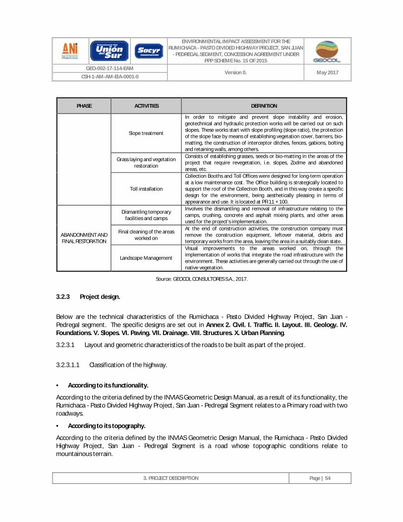
ENVIRONMENTAL IMPACT ASSESSMENT FOR THE RUMICHACA - PASTO DIVIDED HIGHWAY PROJECT, SAN JUAN
- PEDREGAL SEGMENT, CONCESSION AGREEMENT UNDER PPP SCHEME No. 15 OF 2015
GEO-002-17-114-EAM Version 0. May 2017
CSH-1-AM-AM-EIA-0001-0
3. PROJECT DESCRIPTION
Page | 54
PHASE ACTIVITIES DEFINITION
Slope treatment
In order to mitigate and prevent slope instability and erosion, geotechnical and hydraulic protection works will be carried out on such slopes. These works start with slope profiling (slope ratio), the protection of the slope face by means of establishing vegetation cover, barriers, bio-matting, the construction of interceptor ditches, fences, gabions, bolting and retaining walls, among others.
Grass laying and vegetation restoration
Consists of establishing grasses, seeds or bio-matting in the areas of the project that require revegetation, i.e. slopes, Zodme and abandoned areas, etc.
Toll installation
Collection Booths and Toll Offices were designed for long-term operation at a low maintenance cost. The Office building is strategically located to support the roof of the Collection Booth, and in this way create a specific design for the environment, being aesthetically pleasing in terms of appearance and use. It is located at PR 11 + 100.
ABANDONMENT AND FINAL RESTORATION
Dismantling temporary facilities and camps
Involves the dismantling and removal of infrastructure relating to the camps, crushing, concrete and asphalt mixing plants, and other areas used for the project's implementation.
Final cleaning of the areas worked on
At the end of construction activities, the construction company must remove the construction equipment, leftover material, debris and temporary works from the area, leaving the area in a suitably clean state.
Landscape Management
Visual improvements to the areas worked on, through the implementation of works that integrate the road infrastructure with the environment. These activities are generally carried out through the use of native vegetation.
Source: GEOCOL CONSULTORES S.A., 2017.
3.2.3 Project design.
Below are the technical characteristics of the Rumichaca - Pasto Divided Highway Project, San Juan - Pedregal segment. The specific designs are set out in Annex 2. Civil. I. Traffic. II. Layout. III. Geology. IV. Foundations. V. Slopes. VI. Paving. VII. Drainage. VIII. Structures. X. Urban Planning.
3.2.3.1 Layout and geometric characteristics of the roads to be built as part of the project.
3.2.3.1.1 Classification of the highway.
· According to its functionality.
According to the criteria defined by the INVIAS Geometric Design Manual, as a result of its functionality, the Rumichaca - Pasto Divided Highway Project, San Juan - Pedregal Segment relates to a Primary road with two roadways.
· According to its topography.
According to the criteria defined by the INVIAS Geometric Design Manual, the Rumichaca - Pasto Divided Highway Project, San Juan - Pedregal Segment is a road whose topographic conditions relate to mountainous terrain.
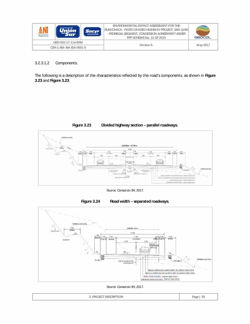
ENVIRONMENTAL IMPACT ASSESSMENT FOR THE RUMICHACA - PASTO DIVIDED HIGHWAY PROJECT, SAN JUAN
- PEDREGAL SEGMENT, CONCESSION AGREEMENT UNDER PPP SCHEME No. 15 OF 2015
GEO-002-17-114-EAM Version 0. May 2017
CSH-1-AM-AM-EIA-0001-0
3. PROJECT DESCRIPTION
Page | 55
3.2.3.1.2 Components.
The following is a description of the characteristics reflected by the road's components, as shown in Figure 3.23 and Figure 3.23.
Figure 3.23 Divided highway section – parallel roadways.
Source: Consorcio SH, 2017.
Figure 3.24 Road width – separated roadways.
Source: Consorcio SH, 2017.
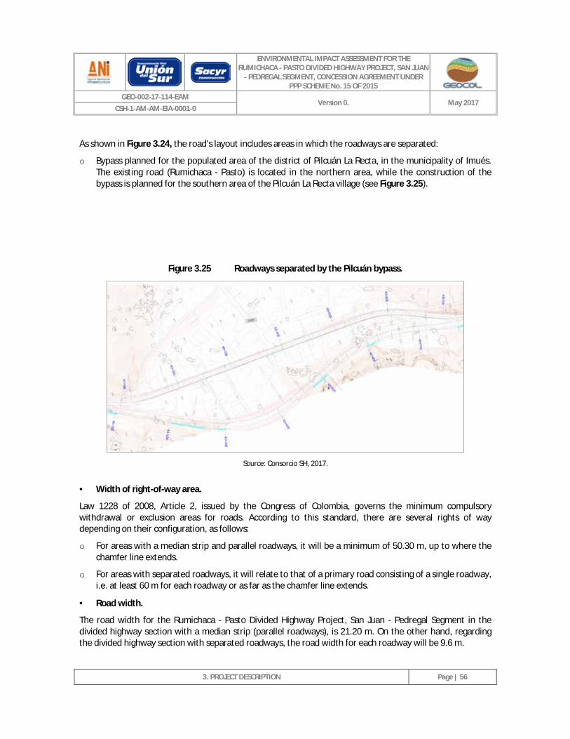
ENVIRONMENTAL IMPACT ASSESSMENT FOR THE RUMICHACA - PASTO DIVIDED HIGHWAY PROJECT, SAN JUAN
- PEDREGAL SEGMENT, CONCESSION AGREEMENT UNDER PPP SCHEME No. 15 OF 2015
GEO-002-17-114-EAM Version 0. May 2017
CSH-1-AM-AM-EIA-0001-0
3. PROJECT DESCRIPTION
Page | 56
As shown in Figure 3.24, the road's layout includes areas in which the roadways are separated:
o Bypass planned for the populated area of the district of Pilcuán La Recta, in the municipality of Imués. The existing road (Rumichaca - Pasto) is located in the northern area, while the construction of the bypass is planned for the southern area of the Pilcuán La Recta village (see Figure 3.25).
Figure 3.25 Roadways separated by the Pilcuán bypass.
Source: Consorcio SH, 2017.
· Width of right-of-way area.
Law 1228 of 2008, Article 2, issued by the Congress of Colombia, governs the minimum compulsory withdrawal or exclusion areas for roads. According to this standard, there are several rights of way depending on their configuration, as follows:
o For areas with a median strip and parallel roadways, it will be a minimum of 50.30 m, up to where the chamfer line extends.
o For areas with separated roadways, it will relate to that of a primary road consisting of a single roadway, i.e. at least 60 m for each roadway or as far as the chamfer line extends.
· Road width.
The road width for the Rumichaca - Pasto Divided Highway Project, San Juan - Pedregal Segment in the divided highway section with a median strip (parallel roadways), is 21.20 m. On the other hand, regarding the divided highway section with separated roadways, the road width for each roadway will be 9.6 m.
ENVIRONMENTAL IMPACT ASSESSMENT FOR THE RUMICHACA - PASTO DIVIDED HIGHWAY PROJECT, SAN JUAN
- PEDREGAL SEGMENT, CONCESSION AGREEMENT UNDER PPP SCHEME No. 15 OF 2015
GEO-002-17-114-EAM Version 0. May 2017
CSH-1-AM-AM-EIA-0001-0
3. PROJECT DESCRIPTION
Page | 57
· Roadway.
The roadways for the Rumichaca - Pasto Divided Highway Project, San Juan - Pedregal Segment, will be 7.30 m wide each.
· Berms.
The Rumichaca - Pasto Divided Highway Project, San Juan - Pedregal Segment, will have internal berms that are 0.50 m wide and external berms that are 1.80 m wide.
· Ditches.
The Rumichaca - Pasto Divided Highway Project, San Juan - Pedregal Segment, will have the following types of ditch:
Side ditches: Triangular cross-section, 1.0 m wide, 0.20 m deep, forming its slopes at an angle of 90°. These will be made with a concrete coating 10 cm thick and reinforced with electro-welded mesh, founded on a layer of granular material and with expansion joints every 2 or 3 m (at the discretion of the construction company).
Median ditch: Located in the roadways' median strip, triangular cross-section, symmetrical, 1.0 m wide, 0.125 m deep, forming its slopes at an angle of 152 °. These will be made with a concrete coating 10 cm thick and reinforced with electro mesh - welded, founded on a layer of granular material, and with expansion joints every 2 or 3 m (at the discretion of the construction company).
Interceptor ditch: These will be located at the foot of the embankment and at the top of the cut, will have a minimum rectangular cross-section of a 0.40 m at the base, and a height of 0.50 m.
Depending on the area that feeds into the interceptor ditches, a series of dimensions has been defined, with sufficient capacity to transport the flow. As a result, interceptor ditches of the following dimensions have been defined:
o Interceptor ditch, rectangular cross-section, base 0.40 m and height 0.50 m (minimum dimension of the interceptor ditch).
o Interceptor ditch, rectangular cross-section, base 0.60 m and height 0.50m.
o Interceptor ditch, trapezoidal cross-section, base 0.60 m, height 0.50m and slope 3H/2V.
o Interceptor ditch, trapezoidal cross-section, base 0.40 m, height 0.50m and slope 1H/1V.
o Interceptor ditch, trapezoidal cross-section, base 0.60 m, height 0.50m and slope 1H/1V.
o Interceptor ditch, trapezoidal cross-section, base 1.0 m, height 0.50 m and slope 3H/2V.
All interceptor ditches shall be covered (covered with 10 cm of concrete and electro-welded mesh), founded on a layer of granular material, and with expansion joints every 2 or 3 m (at the discretion of the construction company). There will be at least 2.0 m of separation between the foot of the embankment slope or the top of the cut slope, and the edge of the interceptor ditch.
Berm gutters: Symmetrical triangular cross-section, 1.0 m wide, 3.0 m deep, coated in concrete.
Channel gutter in access: Symmetrical triangular cross-section, 1.90 m wide, 0.20 m deep, coated in concrete, reinforced with electro-welded mesh, and founded on a layer of granular material.
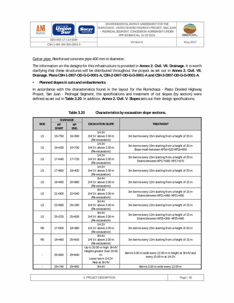
ENVIRONMENTAL IMPACT ASSESSMENT FOR THE RUMICHACA - PASTO DIVIDED HIGHWAY PROJECT, SAN JUAN
- PEDREGAL SEGMENT, CONCESSION AGREEMENT UNDER PPP SCHEME No. 15 OF 2015
GEO-002-17-114-EAM Version 0. May 2017
CSH-1-AM-AM-EIA-0001-0
3. PROJECT DESCRIPTION
Page | 58
Gutter pipe: Reinforced concrete pipe 400 mm in diameter.
The information on the designs for this infrastructure is provided in Annex 2. Civil. VII. Drainage. It is worth clarifying that these structures will be distributed throughout the project as set out in Annex 2. Civil. VII. Drainage. Plans CSH-1-DI07-OD-G-G-0001-A, CSH-2-DI07-OD-G-G-0001-A and CSH-3-DI07-OD-G-G-0001-A.
· Planned slopes in cuts and embankments.
In accordance with the characteristics found in the layout for the Rumichaca - Pasto Divided Highway Project, San Juan - Pedregal Segment, the specifications and treatment of cut slopes (by section) were defined as set out in Table 3.20. In addition, Annex 2. Civil. V. Slopes sets out their design specifications.
Table 3.20 Characteristics by excavation slope sections.
SIDE CHAINAGE
EXCAVATION SLOPE TREATMENT KP START
KP END
LS 15+750 16+390 1H:3V
1H/1V: above 2.00 m (Re-excavation)
3m berms every 15m starting from a height of 20 m
LS 16+430 16+700 1H:3V
1H/1V: above 2.00 m (Re-excavation)
3m berms every 15m starting from a height of 20 m Slope mesh between KP16+520-KP16+650
LS 17+040 17+720 1H:2V
1H/1V: above 2.00 m (Re-excavation)
3m berms every 15m starting from a height of 20 m Drains between KP17+590- KP17+670
LS 17+800 18+400 1H:2V
1H/1V: above 2.00 m (Re-excavation)
3m berms every 15m starting from a height of 20 m
LS 19+450 20+880 3H:4V
1H/1V: above 2.00 m (Re-excavation)
3m berms every 12m starting from a height of 15 m
LS 21+000 22+540 3H:4V
1H/1V: above 2.00 m (Re-excavation)
3m berms every 12m starting from a height of 15 m Drains between KP21+080- KP21+650
LS 22+580 25+180 3H:4V
1H/1V: above 2.00 m (Re-excavation)
3m berms every 12m starting from a height of 15 m
LS 25+220 25+600 3H:4V
1H/1V: above 2.00 m (Re-excavation)
3m berms every 12m starting from a height of 15 m Drains between KP25+300- KP25+560
RS 17+000 18+380 1H:2V
1H/1V: above 2.00 m (Re-excavation)
3m berms every 15m starting from a height of 20 m
RS 19+460 25+600 3H:4V
1H/1V: above 2.00 m (Re-excavation)
3m berms every 12m starting from a height of 15 m
- 25+600 29+640
Up to 20.00 m high: 3H:4V Heights greater than 20.00
m: Lower berm 1H:2V
Rest at 3H:4V
Berms 3.00 m wide every 12.00 m in height at 3H:4V and every 15.00 m at 1H:2V
- 29+740 29+960 3H:4V Berms 3.00 m wide every 12.00 m
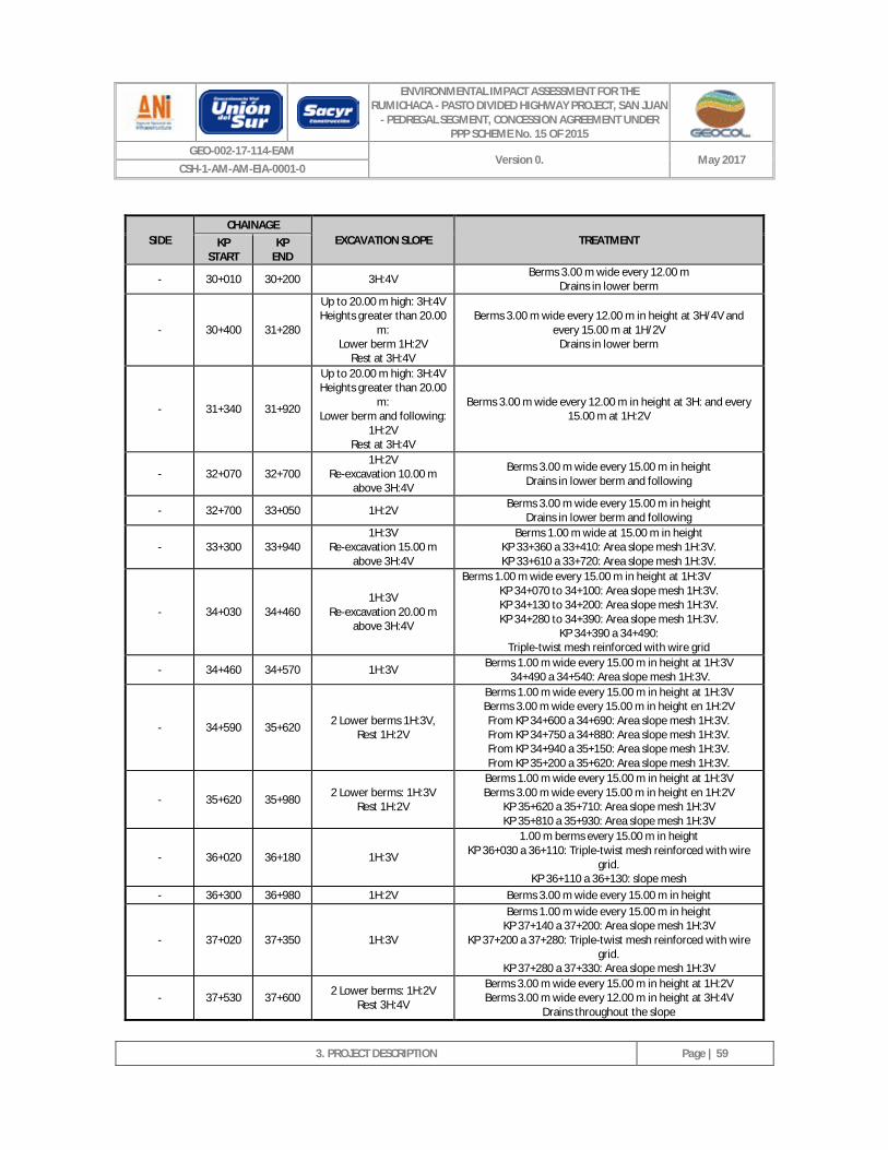
ENVIRONMENTAL IMPACT ASSESSMENT FOR THE RUMICHACA - PASTO DIVIDED HIGHWAY PROJECT, SAN JUAN
- PEDREGAL SEGMENT, CONCESSION AGREEMENT UNDER PPP SCHEME No. 15 OF 2015
GEO-002-17-114-EAM Version 0. May 2017
CSH-1-AM-AM-EIA-0001-0
3. PROJECT DESCRIPTION
Page | 59
SIDE CHAINAGE
EXCAVATION SLOPE TREATMENT KP START
KP END
- 30+010 30+200 3H:4V Berms 3.00 m wide every 12.00 m Drains in lower berm
- 30+400 31+280
Up to 20.00 m high: 3H:4V Heights greater than 20.00
m: Lower berm 1H:2V
Rest at 3H:4V
Berms 3.00 m wide every 12.00 m in height at 3H/4V and every 15.00 m at 1H/2V
Drains in lower berm
- 31+340 31+920
Up to 20.00 m high: 3H:4V Heights greater than 20.00
m: Lower berm and following:
1H:2V Rest at 3H:4V
Berms 3.00 m wide every 12.00 m in height at 3H: and every 15.00 m at 1H:2V
- 32+070 32+700 1H:2V
Re-excavation 10.00 m above 3H:4V
Berms 3.00 m wide every 15.00 m in height Drains in lower berm and following
- 32+700 33+050 1H:2V Berms 3.00 m wide every 15.00 m in height Drains in lower berm and following
- 33+300 33+940 1H:3V
Re-excavation 15.00 m above 3H:4V
Berms 1.00 m wide at 15.00 m in height KP 33+360 a 33+410: Area slope mesh 1H:3V. KP 33+610 a 33+720: Area slope mesh 1H:3V.
- 34+030 34+460 1H:3V
Re-excavation 20.00 m above 3H:4V
Berms 1.00 m wide every 15.00 m in height at 1H:3V KP 34+070 to 34+100: Area slope mesh 1H:3V. KP 34+130 to 34+200: Area slope mesh 1H:3V. KP 34+280 to 34+390: Area slope mesh 1H:3V.
KP 34+390 a 34+490: Triple-twist mesh reinforced with wire grid
- 34+460 34+570 1H:3V Berms 1.00 m wide every 15.00 m in height at 1H:3V 34+490 a 34+540: Area slope mesh 1H:3V.
- 34+590 35+620 2 Lower berms 1H:3V, Rest 1H:2V
Berms 1.00 m wide every 15.00 m in height at 1H:3V Berms 3.00 m wide every 15.00 m in height en 1H:2V From KP 34+600 a 34+690: Area slope mesh 1H:3V. From KP 34+750 a 34+880: Area slope mesh 1H:3V. From KP 34+940 a 35+150: Area slope mesh 1H:3V. From KP 35+200 a 35+620: Area slope mesh 1H:3V.
- 35+620 35+980 2 Lower berms: 1H:3V Rest 1H:2V
Berms 1.00 m wide every 15.00 m in height at 1H:3V Berms 3.00 m wide every 15.00 m in height en 1H:2V
KP 35+620 a 35+710: Area slope mesh 1H:3V KP 35+810 a 35+930: Area slope mesh 1H:3V
- 36+020 36+180 1H:3V
1.00 m berms every 15.00 m in height KP 36+030 a 36+110: Triple-twist mesh reinforced with wire
grid. KP 36+110 a 36+130: slope mesh
- 36+300 36+980 1H:2V Berms 3.00 m wide every 15.00 m in height
- 37+020 37+350 1H:3V
Berms 1.00 m wide every 15.00 m in height KP 37+140 a 37+200: Area slope mesh 1H:3V
KP 37+200 a 37+280: Triple-twist mesh reinforced with wire grid.
KP 37+280 a 37+330: Area slope mesh 1H:3V
- 37+530 37+600 2 Lower berms: 1H:2V Rest 3H:4V
Berms 3.00 m wide every 15.00 m in height at 1H:2V Berms 3.00 m wide every 12.00 m in height at 3H:4V
Drains throughout the slope
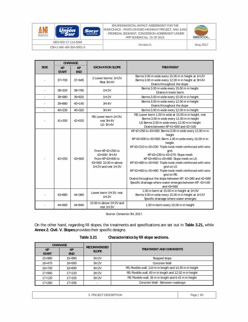
ENVIRONMENTAL IMPACT ASSESSMENT FOR THE RUMICHACA - PASTO DIVIDED HIGHWAY PROJECT, SAN JUAN
- PEDREGAL SEGMENT, CONCESSION AGREEMENT UNDER PPP SCHEME No. 15 OF 2015
GEO-002-17-114-EAM Version 0. May 2017
CSH-1-AM-AM-EIA-0001-0
3. PROJECT DESCRIPTION
Page | 60
SIDE CHAINAGE
EXCAVATION SLOPE TREATMENT KP START
KP END
- 37+700 37+945 2 Lower berms: 1H:2V Rest 3H:4V
Berms 3.00 m wide every 15.00 m in height at 1H:2V Berms 3.00 m wide every 12.00 m in height at 3H:4V
Drains throughout the slope
- 38+320 38+780 1H:2V Berms 3.00 m wide every 15.00 m in height Drains in lower berm
- 38+980 39+820 1H:2V Berms 3.00 m wide every 15.00 m in height
- 39+880 40+140 3H:4V Berms 3.00 m wide every 12.00 m in height Drains throughout the slope
- 40+230 40+320 3H:4V Berms 3.00 m wide every 12.00 m in height
- 41+200 42+020 RS: Lower berm 1H:3V,
rest 3H:4V LD: 3H:4V
RS: Lower berm 1.00 m wide at 15.00 m in height, rest Berms 3.00 m wide every 12.00 m in height
LS: Berms 3.00 m wide every 12.00 m in height Drains between KP 41+600 and 42+100
- 42+250 43+560
From KP 42+250 to 43+000: 3H:4V
From KP 43+000 to 43+560: 10.00 m above 1H:2V and rest 1H:3V
KP 42+250 to 43+000: Berms 3.00 m wide every 12.00 m in height
KP 43+000 to 43+560: Berm 1.00 m wide every 15.00 m in height.
KP 43+210 to 43+230: Triple-twist mesh reinforced with wire grid.
KP 43+230 to 43+270: Slope mesh KP 43+450 to 43+490: Slope mesh on LS
KP 43+490 to 43+540: Triple-twist mesh reinforced with wire grid on LS
KP 43+450 to 43+490: Triple-twist mesh reinforced with wire grid on RS
Drains throughout the slope between KP. 42+280 and 42+580 Specific drainage where water emerges between KP. 43+140
and 43+560
- 43+880 44+360 Lower berm 1H:3V, rest 1H:2V
1.00 m berm at 15.00 m in height at 1H:3V Berms 3.00 m wide every 15.00 m in height at 1H:2V
Specific drainage where water emerges
- 44+660 44+840 10.00 m above 1H:2V and rest 1H:3V 1.00 m berm every 15.00 m in height
Source: Consorcio SH, 2017.
On the other hand, regarding fill slopes, the treatments and specifications are set out in Table 3.21, while Annex 2. Civil. V. Slopes provides their specific designs.
Table 3.21 Characteristics by fill slope sections.
CHAINAGE RECOMMENDED
SLOPE TREATMENT AND COMMENTS KP START
KP END
15+980 15+990 3H:2V Stepped slope 16+470 16+500 3H:2V Concrete Wall 16+720 16+830 3H:2V RS. Flexible wall, 110 m in length and 14.35 m in height
17+060 17+120 3H:2V RS. Flexible wall, 60 m in length and 12.02 m in height
17+120 17+155 3H:2V RS. Flexible wall, 35 m in length and 6.42 m in height
17+260 17+335 - Concrete Wall - Between roadways
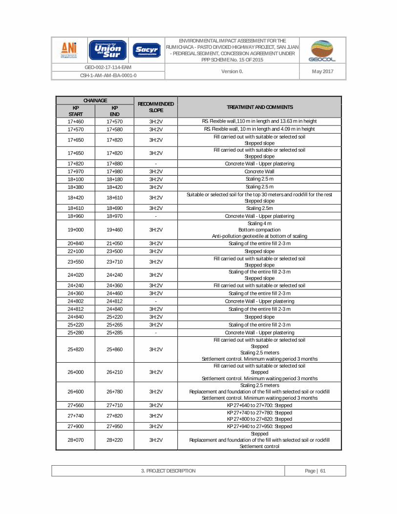
ENVIRONMENTAL IMPACT ASSESSMENT FOR THE RUMICHACA - PASTO DIVIDED HIGHWAY PROJECT, SAN JUAN
- PEDREGAL SEGMENT, CONCESSION AGREEMENT UNDER PPP SCHEME No. 15 OF 2015
GEO-002-17-114-EAM Version 0. May 2017
CSH-1-AM-AM-EIA-0001-0
3. PROJECT DESCRIPTION
Page | 61
CHAINAGE RECOMMENDED
SLOPE TREATMENT AND COMMENTS KP START
KP END
17+460 17+570 3H:2V RS. Flexible wall,110 m in length and 13.63 m in height
17+570 17+580 3H:2V RS. Flexible wall, 10 m in length and 4.09 m in height
17+650 17+820 3H:2V Fill carried out with suitable or selected soil Stepped slope
17+650 17+820 3H:2V Fill carried out with suitable or selected soil Stepped slope
17+820 17+880 - Concrete Wall - Upper plastering 17+970 17+980 3H:2V Concrete Wall 18+100 18+180 3H:2V Scaling 2.5 m
18+380 18+420 3H:2V Scaling 2.5 m
18+420 18+610 3H:2V Suitable or selected soil for the top 30 meters and rockfill for the rest Stepped slope
18+610 18+690 3H:2V Scaling 2.5m 18+960 18+970 - Concrete Wall - Upper plastering
19+000 19+460 3H:2V Scaling 4 m
Bottom compaction Anti-pollution geotextile at bottom of scaling
20+840 21+050 3H:2V Scaling of the entire fill 2-3 m 22+100 23+500 3H:2V Stepped slope
23+550 23+710 3H:2V Fill carried out with suitable or selected soil Stepped slope
24+020 24+240 3H:2V Scaling of the entire fill 2-3 m Stepped slope
24+240 24+360 3H:2V Fill carried out with suitable or selected soil 24+360 24+460 3H:2V Scaling of the entire fill 2-3 m 24+802 24+812 - Concrete Wall - Upper plastering 24+812 24+840 3H:2V Scaling of the entire fill 2-3 m 24+840 25+220 3H:2V Stepped slope 25+220 25+265 3H:2V Scaling of the entire fill 2-3 m 25+280 25+285 - Concrete Wall - Upper plastering
25+820 25+860 3H:2V
Fill carried out with suitable or selected soil Stepped
Scaling 2.5 meters Settlement control. Minimum waiting period 3 months
26+000 26+210 3H:2V Fill carried out with suitable or selected soil
Stepped Settlement control. Minimum waiting period 3 months
26+600 26+780 3H:2V Scaling 2.5 meters
Replacement and foundation of the fill with selected soil or rockfill Settlement control. Minimum waiting period 3 months
27+560 27+710 3H:2V KP 27+640 to 27+700: Stepped
27+740 27+820 3H:2V KP 27+740 to 27+780: Stepped KP 27+800 to 27+820: Stepped
27+900 27+950 3H:2V KP 27+940 to 27+950: Stepped
28+070 28+220 3H:2V Stepped
Replacement and foundation of the fill with selected soil or rockfill Settlement control
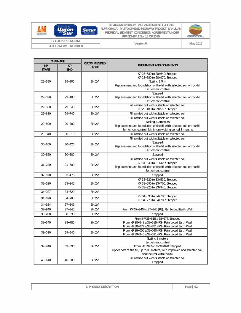
ENVIRONMENTAL IMPACT ASSESSMENT FOR THE RUMICHACA - PASTO DIVIDED HIGHWAY PROJECT, SAN JUAN
- PEDREGAL SEGMENT, CONCESSION AGREEMENT UNDER PPP SCHEME No. 15 OF 2015
GEO-002-17-114-EAM Version 0. May 2017
CSH-1-AM-AM-EIA-0001-0
3. PROJECT DESCRIPTION
Page | 62
CHAINAGE RECOMMENDED
SLOPE TREATMENT AND COMMENTS KP START
KP END
28+580 28+980 3H:2V
KP 28+580 to 28+640: Stepped KP 28+780 to 28+970: Stepped
Scaling 2.5 m Replacement and foundation of the fill with selected soil or rockfill
Settlement control
29+020 29+180 3H:2V Stepped
Replacement and foundation of the fill with selected soil or rockfill Settlement control
29+360 29+540 3H:2V Fill carried out with suitable or selected soil KP 29+400 to 29+510: Stepped
29+630 29+740 3H:2V Fill carried out with suitable or selected soil
29+800 29+880 3H:2V
Fill carried out with suitable or selected soil Scaling 3.0 metros
Replacement and foundation of the fill with selected soil or rockfill Settlement control. Minimum waiting period 3 months
29+940 30+010 3H:2V Fill carried out with suitable or selected soil
30+200 30+420 3H:2V
Fill carried out with suitable or selected soil Stepped
Replacement and foundation of the fill with selected soil or rockfill Settlement control
30+520 30+580 3H:2V Stepped
31+280 31+600 3H:2V
Fill carried out with suitable or selected soil KP 31+340 to 31+420: Stepped
Replacement and foundation of the fill with selected soil or rockfill Settlement control
32+070 33+470 3H:2V Stepped
33+520 33+940 3H:2V KP 33+520 to 33+530: Stepped KP 33+690 to 33+700: Stepped KP 33+920 to 33+940: Stepped
34+027 34+620 3H:2V -
34+690 34+780 3H:2V KP 34+690 to 34+700: Stepped KP 34+770 to 34+780: Stepped
34+924 37+349 3H:2V - 37+940 37+945 3H:2V From KP 37+940 to 37+945 (RS): Reinforced Earth Wall 38+280 38+330 3H:2V Stepped
38+540 38+780 3H:2V From KP 38+615 a 38+677: Stepped
From KP 38+548 a 38+615 (RS): Reinforced Earth Wall From KP 38+677 a 38+781 (RS): Reinforced Earth Wall
39+010 39+540 3H:2V From KP 39+006 a 39+040 (RS): Reinforced Earth Wall From KP 39+340 a 39+521 (RS): Reinforced Earth Wall
39+740 39+890 3H:2V
Scaling 3 meters Settlement control
From KP 39+740 to 39+820: Stepped Upper part of the fill, up to 30 meters, with improved and selected soil,
and the rest with rockfill
40+140 40+280 3H:2V Fill carried out with suitable or selected soil Stepped
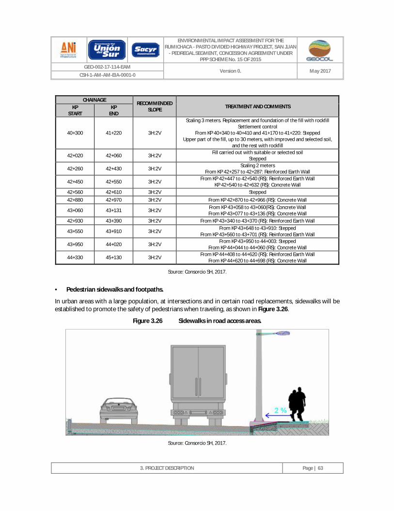
ENVIRONMENTAL IMPACT ASSESSMENT FOR THE RUMICHACA - PASTO DIVIDED HIGHWAY PROJECT, SAN JUAN
- PEDREGAL SEGMENT, CONCESSION AGREEMENT UNDER PPP SCHEME No. 15 OF 2015
GEO-002-17-114-EAM Version 0. May 2017
CSH-1-AM-AM-EIA-0001-0
3. PROJECT DESCRIPTION
Page | 63
CHAINAGE RECOMMENDED
SLOPE TREATMENT AND COMMENTS KP START
KP END
40+300 41+220 3H:2V
Scaling 3 meters. Replacement and foundation of the fill with rockfill Settlement control
From KP 40+340 to 40+410 and 41+170 to 41+220: Stepped Upper part of the fill, up to 30 meters, with improved and selected soil,
and the rest with rockfill
42+020 42+060 3H:2V Fill carried out with suitable or selected soil Stepped
42+260 42+430 3H:2V Scaling 2 meters From KP 42+257 to 42+287: Reinforced Earth Wall
42+450 42+550 3H:2V From KP 42+447 to 42+540 (RS): Reinforced Earth Wall KP 42+540 to 42+632 (RS): Concrete Wall
42+560 42+610 3H:2V Stepped 42+880 42+970 3H:2V From KP 42+870 to 42+966 (RS): Concrete Wall
43+060 43+131 3H:2V From KP 43+058 to 43+060(RS): Concrete Wall From KP 43+077 to 43+136 (RS): Concrete Wall
42+930 43+390 3H:2V From KP 43+340 to 43+370 (RS): Reinforced Earth Wall
43+550 43+910 3H:2V From KP 43+648 to 43+910: Stepped From KP 43+560 to 43+701 (RS): Reinforced Earth Wall
43+950 44+020 3H:2V From KP 43+950 to 44+003: Stepped From KP 44+044 to 44+060 (RS): Concrete Wall
44+330 45+130 3H:2V From KP 44+408 to 44+620 (RS): Reinforced Earth Wall From KP 44+620 to 44+698 (RS): Concrete Wall
Source: Consorcio SH, 2017.
· Pedestrian sidewalks and footpaths.
In urban areas with a large population, at intersections and in certain road replacements, sidewalks will be established to promote the safety of pedestrians when traveling, as shown in Figure 3.26.
Figure 3.26 Sidewalks in road access areas.
Source: Consorcio SH, 2017.
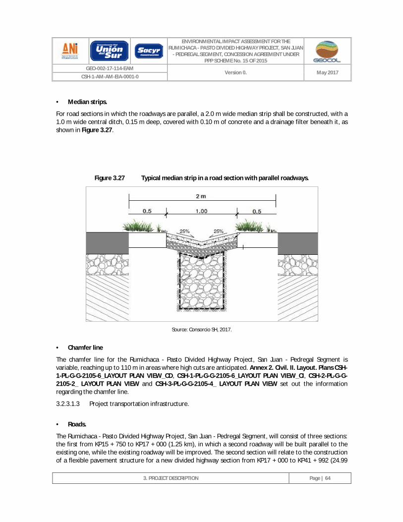
ENVIRONMENTAL IMPACT ASSESSMENT FOR THE RUMICHACA - PASTO DIVIDED HIGHWAY PROJECT, SAN JUAN
- PEDREGAL SEGMENT, CONCESSION AGREEMENT UNDER PPP SCHEME No. 15 OF 2015
GEO-002-17-114-EAM Version 0. May 2017
CSH-1-AM-AM-EIA-0001-0
3. PROJECT DESCRIPTION
Page | 64
· Median strips.
For road sections in which the roadways are parallel, a 2.0 m wide median strip shall be constructed, with a 1.0 m wide central ditch, 0.15 m deep, covered with 0.10 m of concrete and a drainage filter beneath it, as shown in Figure 3.27.
Figure 3.27 Typical median strip in a road section with parallel roadways.
Source: Consorcio SH, 2017.
· Chamfer line
The chamfer line for the Rumichaca - Pasto Divided Highway Project, San Juan - Pedregal Segment is variable, reaching up to 110 m in areas where high cuts are anticipated. Annex 2. Civil. II. Layout. Plans CSH-1-PL-G-G-2105-6_LAYOUT PLAN VIEW_CD, CSH-1-PL-G-G-2105-6_LAYOUT PLAN VIEW_CI, CSH-2-PL-G-G-2105-2_ LAYOUT PLAN VIEW and CSH-3-PL-G-G-2105-4_ LAYOUT PLAN VIEW set out the information regarding the chamfer line.
3.2.3.1.3 Project transportation infrastructure.
· Roads.
The Rumichaca - Pasto Divided Highway Project, San Juan - Pedregal Segment, will consist of three sections: the first from KP15 + 750 to KP17 + 000 (1.25 km), in which a second roadway will be built parallel to the existing one, while the existing roadway will be improved. The second section will relate to the construction of a flexible pavement structure for a new divided highway section from KP17 + 000 to KP41 + 992 (24.99
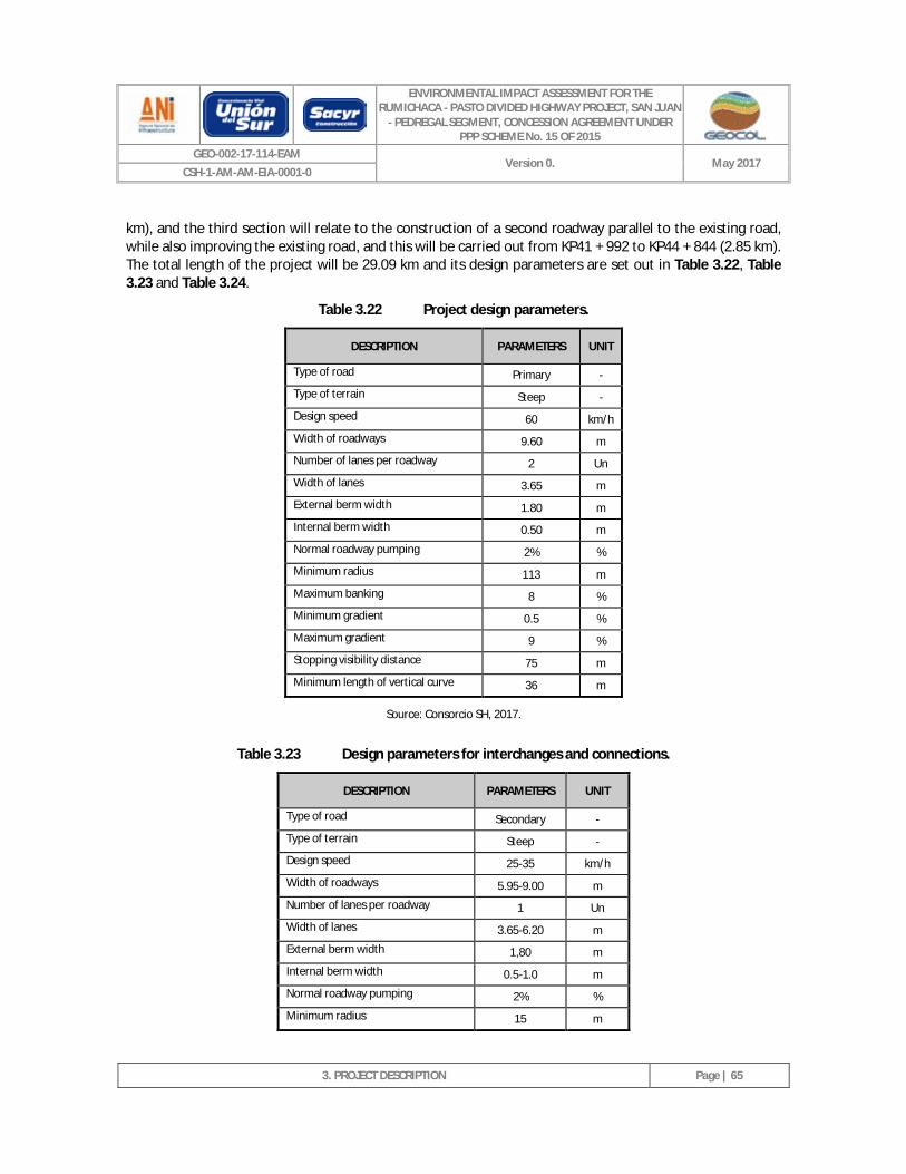
ENVIRONMENTAL IMPACT ASSESSMENT FOR THE RUMICHACA - PASTO DIVIDED HIGHWAY PROJECT, SAN JUAN
- PEDREGAL SEGMENT, CONCESSION AGREEMENT UNDER PPP SCHEME No. 15 OF 2015
GEO-002-17-114-EAM Version 0. May 2017
CSH-1-AM-AM-EIA-0001-0
3. PROJECT DESCRIPTION
Page | 65
km), and the third section will relate to the construction of a second roadway parallel to the existing road, while also improving the existing road, and this will be carried out from KP41 + 992 to KP44 + 844 (2.85 km). The total length of the project will be 29.09 km and its design parameters are set out in Table 3.22, Table 3.23 and Table 3.24.
Table 3.22 Project design parameters.
DESCRIPTION PARAMETERS UNIT
Type of road Primary -
Type of terrain Steep -
Design speed 60 km/h
Width of roadways 9.60 m
Number of lanes per roadway 2 Un
Width of lanes 3.65 m
External berm width 1.80 m
Internal berm width 0.50 m
Normal roadway pumping 2% %
Minimum radius 113 m
Maximum banking 8 %
Minimum gradient 0.5 %
Maximum gradient 9 %
Stopping visibility distance 75 m
Minimum length of vertical curve 36 m
Source: Consorcio SH, 2017.
Table 3.23 Design parameters for interchanges and connections.
DESCRIPTION PARAMETERS UNIT
Type of road Secondary -
Type of terrain Steep -
Design speed 25-35 km/h
Width of roadways 5.95-9.00 m
Number of lanes per roadway 1 Un
Width of lanes 3.65-6.20 m
External berm width 1,80 m
Internal berm width 0.5-1.0 m
Normal roadway pumping 2% %
Minimum radius 15 m
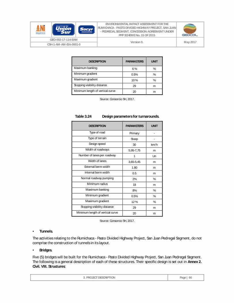
ENVIRONMENTAL IMPACT ASSESSMENT FOR THE RUMICHACA - PASTO DIVIDED HIGHWAY PROJECT, SAN JUAN
- PEDREGAL SEGMENT, CONCESSION AGREEMENT UNDER PPP SCHEME No. 15 OF 2015
GEO-002-17-114-EAM Version 0. May 2017
CSH-1-AM-AM-EIA-0001-0
3. PROJECT DESCRIPTION
Page | 66
DESCRIPTION PARAMETERS UNIT
Maximum banking 6 % %
Minimum gradient 0.5% %
Maximum gradient 10 % %
Stopping visibility distance 29 m
Minimum length of vertical curve 20 m
Source: Consorcio SH, 2017.
Table 3.24 Design parameters for turnarounds.
DESCRIPTION PARAMETERS UNIT
Type of road Primary -
Type of terrain Steep -
Design speed 30 km/h
Width of roadways 5,95-7,75 m
Number of lanes per roadway 1 Un
Width of lanes 3,65-5,45 m
External berm width 1.80 m
Internal berm width 0.5 m
Normal roadway pumping 2% %
Minimum radius 18 m
Maximum banking 8% %
Minimum gradient 0.5% %
Maximum gradient 12 % %
Stopping visibility distance 29 m
Minimum length of vertical curve 20 m
Source: Consorcio SH, 2017.
· Tunnels.
The activities relating to the Rumichaca - Pasto Divided Highway Project, San Juan Pedregal Segment, do not comprise the construction of tunnels in its layout.
· Bridges.
Five (5) bridges will be built for the Rumichaca - Pasto Divided Highway Project, San Juan Pedregal Segment. The following is a general description of each of these structures. Their specific design is set out in Annex 2. Civil. VIII. Structures:
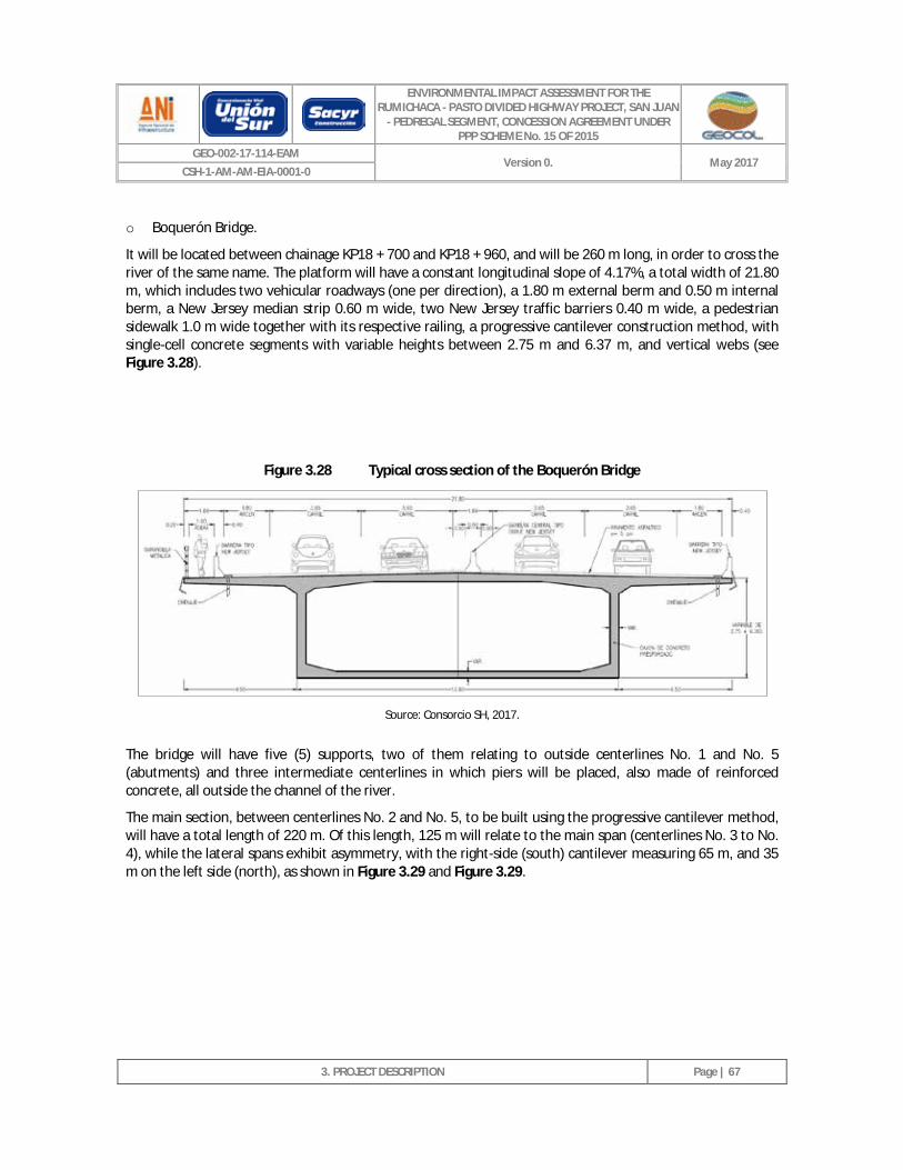
ENVIRONMENTAL IMPACT ASSESSMENT FOR THE RUMICHACA - PASTO DIVIDED HIGHWAY PROJECT, SAN JUAN
- PEDREGAL SEGMENT, CONCESSION AGREEMENT UNDER PPP SCHEME No. 15 OF 2015
GEO-002-17-114-EAM Version 0. May 2017
CSH-1-AM-AM-EIA-0001-0
3. PROJECT DESCRIPTION
Page | 67
o Boquerón Bridge.
It will be located between chainage KP18 + 700 and KP18 + 960, and will be 260 m long, in order to cross the river of the same name. The platform will have a constant longitudinal slope of 4.17%, a total width of 21.80 m, which includes two vehicular roadways (one per direction), a 1.80 m external berm and 0.50 m internal berm, a New Jersey median strip 0.60 m wide, two New Jersey traffic barriers 0.40 m wide, a pedestrian sidewalk 1.0 m wide together with its respective railing, a progressive cantilever construction method, with single-cell concrete segments with variable heights between 2.75 m and 6.37 m, and vertical webs (see Figure 3.28).
Figure 3.28 Typical cross section of the Boquerón Bridge
Source: Consorcio SH, 2017.
The bridge will have five (5) supports, two of them relating to outside centerlines No. 1 and No. 5 (abutments) and three intermediate centerlines in which piers will be placed, also made of reinforced concrete, all outside the channel of the river.
The main section, between centerlines No. 2 and No. 5, to be built using the progressive cantilever method, will have a total length of 220 m. Of this length, 125 m will relate to the main span (centerlines No. 3 to No. 4), while the lateral spans exhibit asymmetry, with the right-side (south) cantilever measuring 65 m, and 35 m on the left side (north), as shown in Figure 3.29 and Figure 3.29.
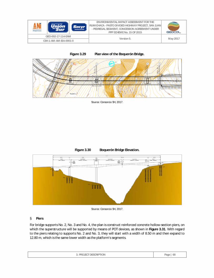
ENVIRONMENTAL IMPACT ASSESSMENT FOR THE RUMICHACA - PASTO DIVIDED HIGHWAY PROJECT, SAN JUAN
- PEDREGAL SEGMENT, CONCESSION AGREEMENT UNDER PPP SCHEME No. 15 OF 2015
GEO-002-17-114-EAM Version 0. May 2017
CSH-1-AM-AM-EIA-0001-0
3. PROJECT DESCRIPTION
Page | 68
Figure 3.29 Plan view of the Boquerón Bridge.
Source: Consorcio SH, 2017.
Figure 3.30 Boquerón Bridge Elevation.
Source: Consorcio SH, 2017.
§ Piers
For bridge supports No. 2, No. 3 and No. 4, the plan is construct reinforced concrete hollow-section piers, on which the superstructure will be supported by means of POT devices, as shown in Figure 3.31. With regard to the piers relating to supports No. 2 and No. 3, they will start with a width of 8.50 m and then expand to 12.80 m, which is the same lower width as the platform's segments.
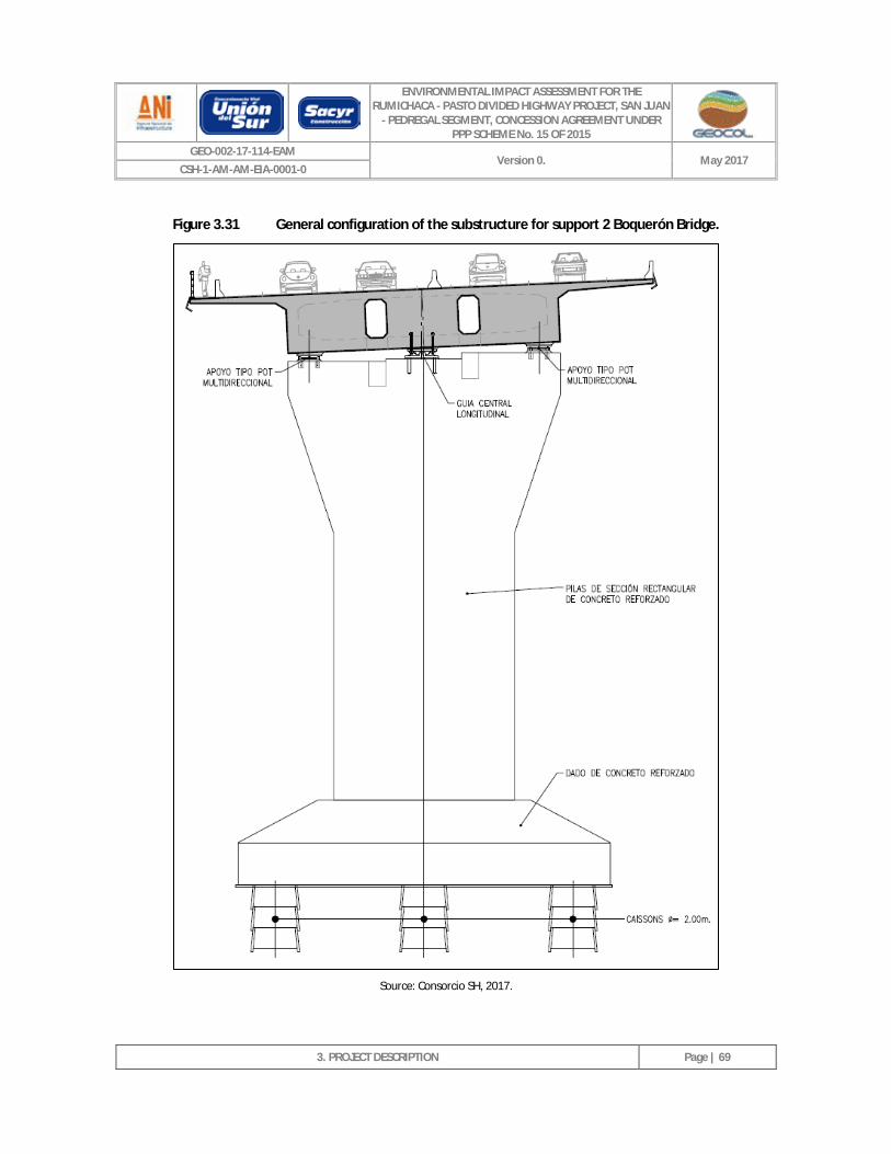
ENVIRONMENTAL IMPACT ASSESSMENT FOR THE RUMICHACA - PASTO DIVIDED HIGHWAY PROJECT, SAN JUAN
- PEDREGAL SEGMENT, CONCESSION AGREEMENT UNDER PPP SCHEME No. 15 OF 2015
GEO-002-17-114-EAM Version 0. May 2017
CSH-1-AM-AM-EIA-0001-0
3. PROJECT DESCRIPTION
Page | 69
Figure 3.31 General configuration of the substructure for support 2 Boquerón Bridge.
Source: Consorcio SH, 2017.
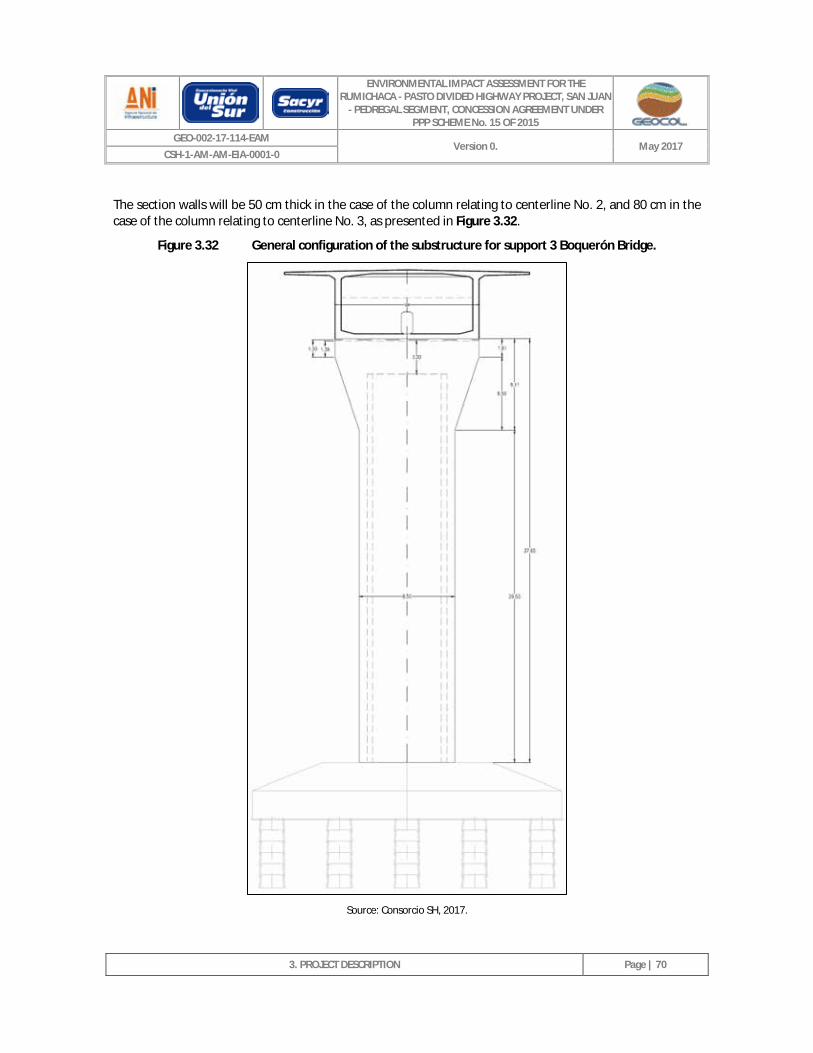
ENVIRONMENTAL IMPACT ASSESSMENT FOR THE RUMICHACA - PASTO DIVIDED HIGHWAY PROJECT, SAN JUAN
- PEDREGAL SEGMENT, CONCESSION AGREEMENT UNDER PPP SCHEME No. 15 OF 2015
GEO-002-17-114-EAM Version 0. May 2017
CSH-1-AM-AM-EIA-0001-0
3. PROJECT DESCRIPTION
Page | 70
The section walls will be 50 cm thick in the case of the column relating to centerline No. 2, and 80 cm in the case of the column relating to centerline No. 3, as presented in Figure 3.32.
Figure 3.32 General configuration of the substructure for support 3 Boquerón Bridge.
Source: Consorcio SH, 2017.
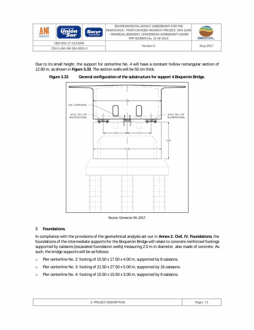
ENVIRONMENTAL IMPACT ASSESSMENT FOR THE RUMICHACA - PASTO DIVIDED HIGHWAY PROJECT, SAN JUAN
- PEDREGAL SEGMENT, CONCESSION AGREEMENT UNDER PPP SCHEME No. 15 OF 2015
GEO-002-17-114-EAM Version 0. May 2017
CSH-1-AM-AM-EIA-0001-0
3. PROJECT DESCRIPTION
Page | 71
Due to its small height, the support for centerline No. 4 will have a constant hollow rectangular section of 12.80 m, as shown in Figure 3.33. The section walls will be 50 cm thick.
Figure 3.33 General configuration of the substructure for support 4 Boquerón Bridge.
Source: Consorcio SH, 2017.
§ Foundations.
In compliance with the provisions of the geotechnical analysis set out in Annex 2. Civil. IV. Foundations, the foundations of the intermediate supports for the Boquerón Bridge will relate to concrete reinforced footings supported by caissons (excavated foundation wells) measuring 2.0 m in diameter, also made of concrete. As such, the bridge supports will be as follows:
o Pier centerline No. 2: footing of 15.50 x 17.50 x 4.00 m, supported by 8 caissons.
o Pier centerline No. 3: footing of 21.50 x 27.50 x 5.00 m, supported by 16 caissons.
o Pier centerline No. 4: footing of 15.50 x 15.50 x 3.00 m, supported by 9 caissons.
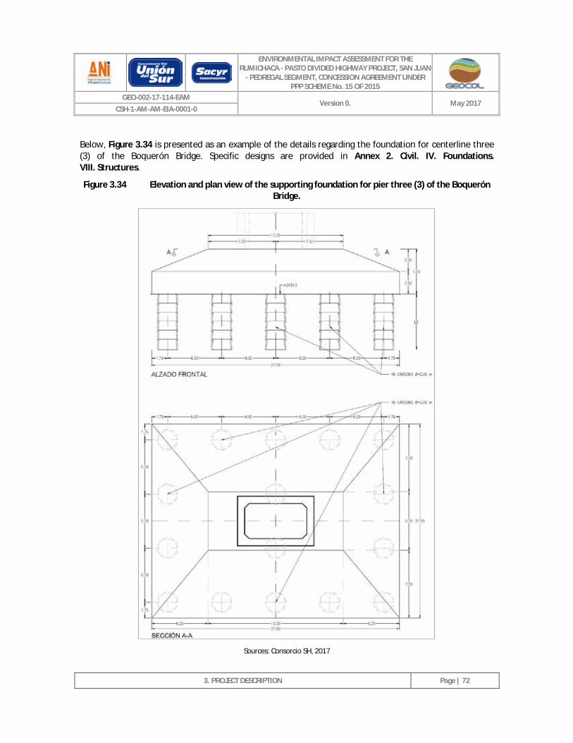
ENVIRONMENTAL IMPACT ASSESSMENT FOR THE RUMICHACA - PASTO DIVIDED HIGHWAY PROJECT, SAN JUAN
- PEDREGAL SEGMENT, CONCESSION AGREEMENT UNDER PPP SCHEME No. 15 OF 2015
GEO-002-17-114-EAM Version 0. May 2017
CSH-1-AM-AM-EIA-0001-0
3. PROJECT DESCRIPTION
Page | 72
Below, Figure 3.34 is presented as an example of the details regarding the foundation for centerline three (3) of the Boquerón Bridge. Specific designs are provided in Annex 2. Civil. IV. Foundations. VIII. Structures.
Figure 3.34 Elevation and plan view of the supporting foundation for pier three (3) of the Boquerón Bridge.
Sources: Consorcio SH, 2017
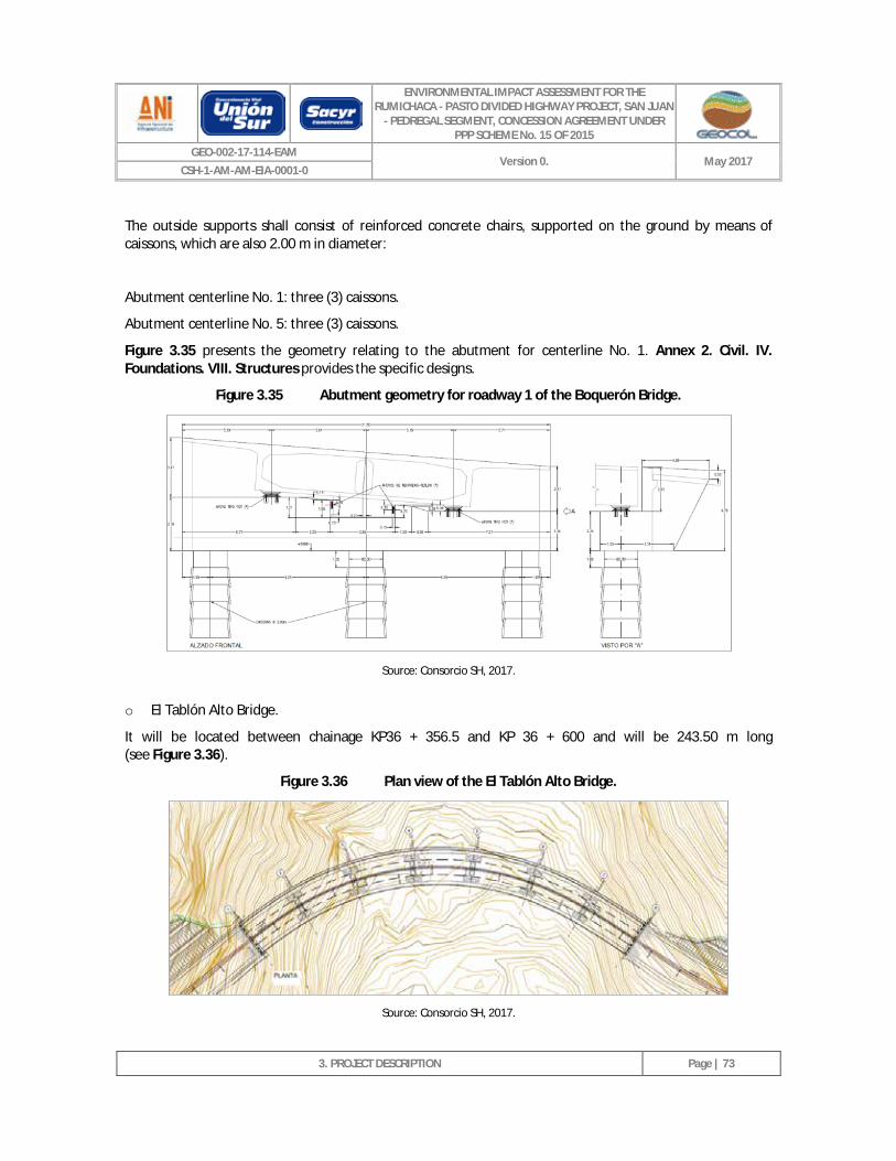
ENVIRONMENTAL IMPACT ASSESSMENT FOR THE RUMICHACA - PASTO DIVIDED HIGHWAY PROJECT, SAN JUAN
- PEDREGAL SEGMENT, CONCESSION AGREEMENT UNDER PPP SCHEME No. 15 OF 2015
GEO-002-17-114-EAM Version 0. May 2017
CSH-1-AM-AM-EIA-0001-0
3. PROJECT DESCRIPTION
Page | 73
The outside supports shall consist of reinforced concrete chairs, supported on the ground by means of caissons, which are also 2.00 m in diameter:
Abutment centerline No. 1: three (3) caissons.
Abutment centerline No. 5: three (3) caissons.
Figure 3.35 presents the geometry relating to the abutment for centerline No. 1. Annex 2. Civil. IV. Foundations. VIII. Structures provides the specific designs.
Figure 3.35 Abutment geometry for roadway 1 of the Boquerón Bridge.
Source: Consorcio SH, 2017.
o El Tablón Alto Bridge.
It will be located between chainage KP36 + 356.5 and KP 36 + 600 and will be 243.50 m long (see Figure 3.36).
Figure 3.36 Plan view of the El Tablón Alto Bridge.
Source: Consorcio SH, 2017.
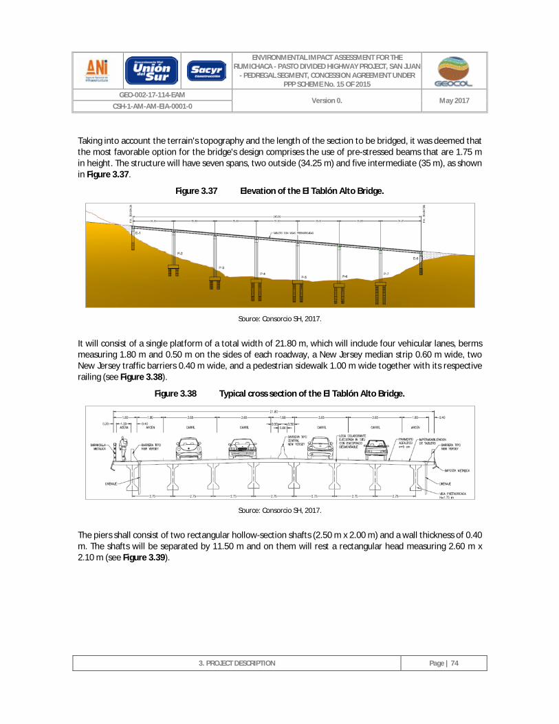
ENVIRONMENTAL IMPACT ASSESSMENT FOR THE RUMICHACA - PASTO DIVIDED HIGHWAY PROJECT, SAN JUAN
- PEDREGAL SEGMENT, CONCESSION AGREEMENT UNDER PPP SCHEME No. 15 OF 2015
GEO-002-17-114-EAM Version 0. May 2017
CSH-1-AM-AM-EIA-0001-0
3. PROJECT DESCRIPTION
Page | 74
Taking into account the terrain's topography and the length of the section to be bridged, it was deemed that the most favorable option for the bridge's design comprises the use of pre-stressed beams that are 1.75 m in height. The structure will have seven spans, two outside (34.25 m) and five intermediate (35 m), as shown in Figure 3.37.
Figure 3.37 Elevation of the El Tablón Alto Bridge.
Source: Consorcio SH, 2017.
It will consist of a single platform of a total width of 21.80 m, which will include four vehicular lanes, berms measuring 1.80 m and 0.50 m on the sides of each roadway, a New Jersey median strip 0.60 m wide, two New Jersey traffic barriers 0.40 m wide, and a pedestrian sidewalk 1.00 m wide together with its respective railing (see Figure 3.38).
Figure 3.38 Typical cross section of the El Tablón Alto Bridge.
Source: Consorcio SH, 2017.
The piers shall consist of two rectangular hollow-section shafts (2.50 m x 2.00 m) and a wall thickness of 0.40 m. The shafts will be separated by 11.50 m and on them will rest a rectangular head measuring 2.60 m x 2.10 m (see Figure 3.39).
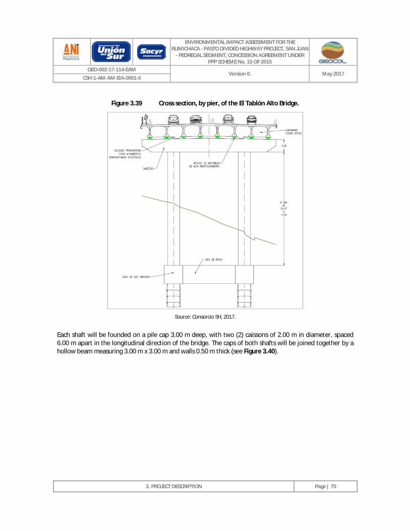
ENVIRONMENTAL IMPACT ASSESSMENT FOR THE RUMICHACA - PASTO DIVIDED HIGHWAY PROJECT, SAN JUAN
- PEDREGAL SEGMENT, CONCESSION AGREEMENT UNDER PPP SCHEME No. 15 OF 2015
GEO-002-17-114-EAM Version 0. May 2017
CSH-1-AM-AM-EIA-0001-0
3. PROJECT DESCRIPTION
Page | 75
Figure 3.39 Cross section, by pier, of the El Tablón Alto Bridge.
Source: Consorcio SH, 2017.
Each shaft will be founded on a pile cap 3.00 m deep, with two (2) caissons of 2.00 m in diameter, spaced 6.00 m apart in the longitudinal direction of the bridge. The caps of both shafts will be joined together by a hollow beam measuring 3.00 m x 3.00 m and walls 0.50 m thick (see Figure 3.40).
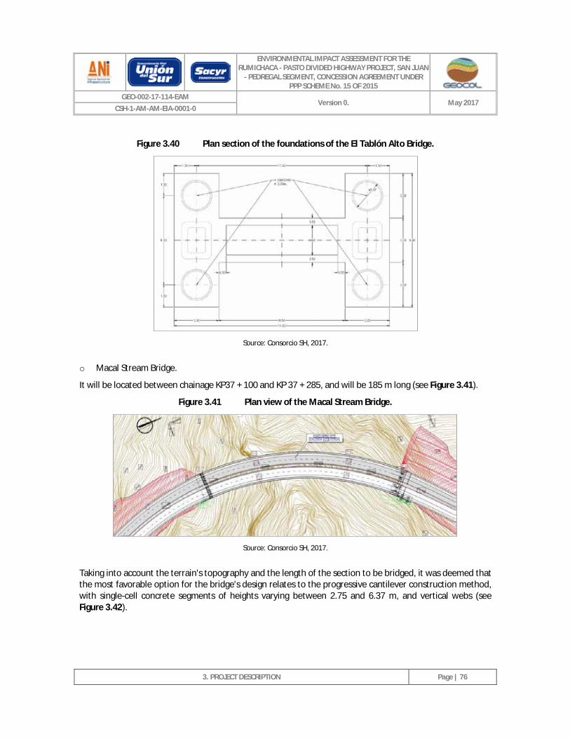
ENVIRONMENTAL IMPACT ASSESSMENT FOR THE RUMICHACA - PASTO DIVIDED HIGHWAY PROJECT, SAN JUAN
- PEDREGAL SEGMENT, CONCESSION AGREEMENT UNDER PPP SCHEME No. 15 OF 2015
GEO-002-17-114-EAM Version 0. May 2017
CSH-1-AM-AM-EIA-0001-0
3. PROJECT DESCRIPTION
Page | 76
Figure 3.40 Plan section of the foundations of the El Tablón Alto Bridge.
Source: Consorcio SH, 2017.
o Macal Stream Bridge.
It will be located between chainage KP37 + 100 and KP 37 + 285, and will be 185 m long (see Figure 3.41).
Figure 3.41 Plan view of the Macal Stream Bridge.
Source: Consorcio SH, 2017.
Taking into account the terrain's topography and the length of the section to be bridged, it was deemed that the most favorable option for the bridge's design relates to the progressive cantilever construction method, with single-cell concrete segments of heights varying between 2.75 and 6.37 m, and vertical webs (see Figure 3.42).
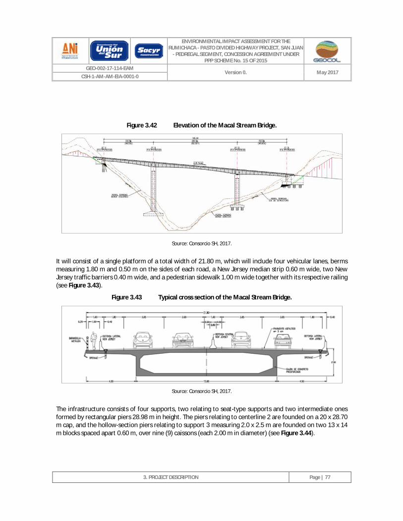
ENVIRONMENTAL IMPACT ASSESSMENT FOR THE RUMICHACA - PASTO DIVIDED HIGHWAY PROJECT, SAN JUAN
- PEDREGAL SEGMENT, CONCESSION AGREEMENT UNDER PPP SCHEME No. 15 OF 2015
GEO-002-17-114-EAM Version 0. May 2017
CSH-1-AM-AM-EIA-0001-0
3. PROJECT DESCRIPTION
Page | 77
Figure 3.42 Elevation of the Macal Stream Bridge.
Source: Consorcio SH, 2017.
It will consist of a single platform of a total width of 21.80 m, which will include four vehicular lanes, berms measuring 1.80 m and 0.50 m on the sides of each road, a New Jersey median strip 0.60 m wide, two New Jersey traffic barriers 0.40 m wide, and a pedestrian sidewalk 1.00 m wide together with its respective railing (see Figure 3.43).
Figure 3.43 Typical cross section of the Macal Stream Bridge.
Source: Consorcio SH, 2017.
The infrastructure consists of four supports, two relating to seat-type supports and two intermediate ones formed by rectangular piers 28.98 m in height. The piers relating to centerline 2 are founded on a 20 x 28.70 m cap, and the hollow-section piers relating to support 3 measuring 2.0 x 2.5 m are founded on two 13 x 14 m blocks spaced apart 0.60 m, over nine (9) caissons (each 2.00 m in diameter) (see Figure 3.44).
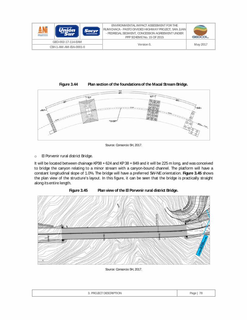
ENVIRONMENTAL IMPACT ASSESSMENT FOR THE RUMICHACA - PASTO DIVIDED HIGHWAY PROJECT, SAN JUAN
- PEDREGAL SEGMENT, CONCESSION AGREEMENT UNDER PPP SCHEME No. 15 OF 2015
GEO-002-17-114-EAM Version 0. May 2017
CSH-1-AM-AM-EIA-0001-0
3. PROJECT DESCRIPTION
Page | 78
Figure 3.44 Plan section of the foundations of the Macal Stream Bridge.
Source: Consorcio SH, 2017.
o El Porvenir rural district Bridge.
It will be located between chainage KP38 + 624 and KP 38 + 849 and it will be 225 m long, and was conceived to bridge the canyon relating to a minor stream with a canyon-bound channel. The platform will have a constant longitudinal slope of 1.0%. The bridge will have a preferred SW-NE orientation. Figure 3.45 shows the plan view of the structure’s layout. In this figure, it can be seen that the bridge is practically straight along its entire length.
Figure 3.45 Plan view of the El Porvenir rural district Bridge.
Source: Consorcio SH, 2017.
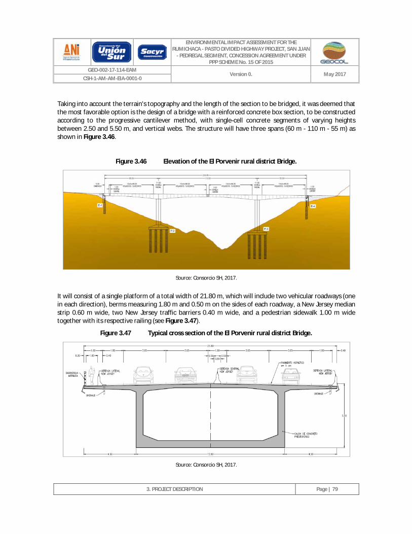
ENVIRONMENTAL IMPACT ASSESSMENT FOR THE RUMICHACA - PASTO DIVIDED HIGHWAY PROJECT, SAN JUAN
- PEDREGAL SEGMENT, CONCESSION AGREEMENT UNDER PPP SCHEME No. 15 OF 2015
GEO-002-17-114-EAM Version 0. May 2017
CSH-1-AM-AM-EIA-0001-0
3. PROJECT DESCRIPTION
Page | 79
Taking into account the terrain's topography and the length of the section to be bridged, it was deemed that the most favorable option is the design of a bridge with a reinforced concrete box section, to be constructed according to the progressive cantilever method, with single-cell concrete segments of varying heights between 2.50 and 5.50 m, and vertical webs. The structure will have three spans (60 m - 110 m - 55 m) as shown in Figure 3.46.
Figure 3.46 Elevation of the El Porvenir rural district Bridge.
Source: Consorcio SH, 2017.
It will consist of a single platform of a total width of 21.80 m, which will include two vehicular roadways (one in each direction), berms measuring 1.80 m and 0.50 m on the sides of each roadway, a New Jersey median strip 0.60 m wide, two New Jersey traffic barriers 0.40 m wide, and a pedestrian sidewalk 1.00 m wide together with its respective railing (see Figure 3.47).
Figure 3.47 Typical cross section of the El Porvenir rural district Bridge.
Source: Consorcio SH, 2017.
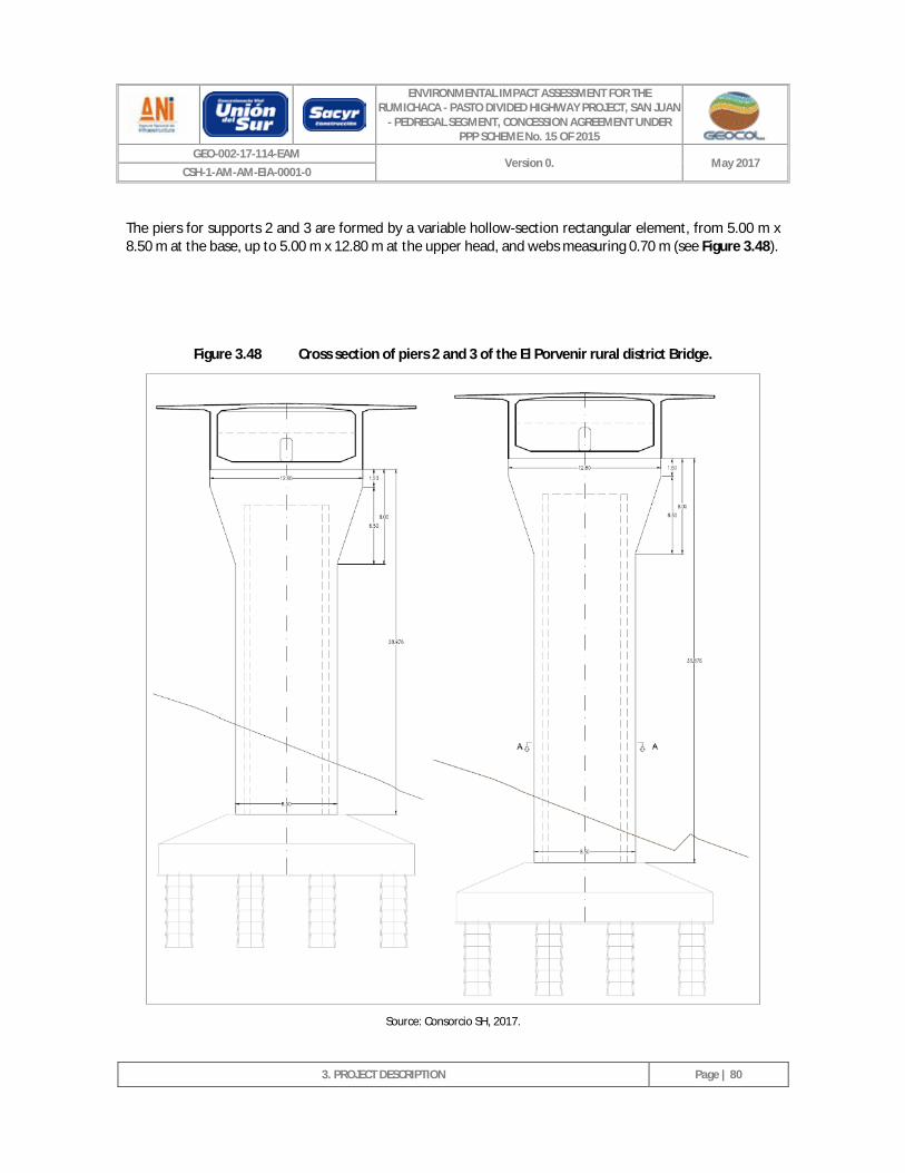
ENVIRONMENTAL IMPACT ASSESSMENT FOR THE RUMICHACA - PASTO DIVIDED HIGHWAY PROJECT, SAN JUAN
- PEDREGAL SEGMENT, CONCESSION AGREEMENT UNDER PPP SCHEME No. 15 OF 2015
GEO-002-17-114-EAM Version 0. May 2017
CSH-1-AM-AM-EIA-0001-0
3. PROJECT DESCRIPTION
Page | 80
The piers for supports 2 and 3 are formed by a variable hollow-section rectangular element, from 5.00 m x 8.50 m at the base, up to 5.00 m x 12.80 m at the upper head, and webs measuring 0.70 m (see Figure 3.48).
Figure 3.48 Cross section of piers 2 and 3 of the El Porvenir rural district Bridge.
Source: Consorcio SH, 2017.
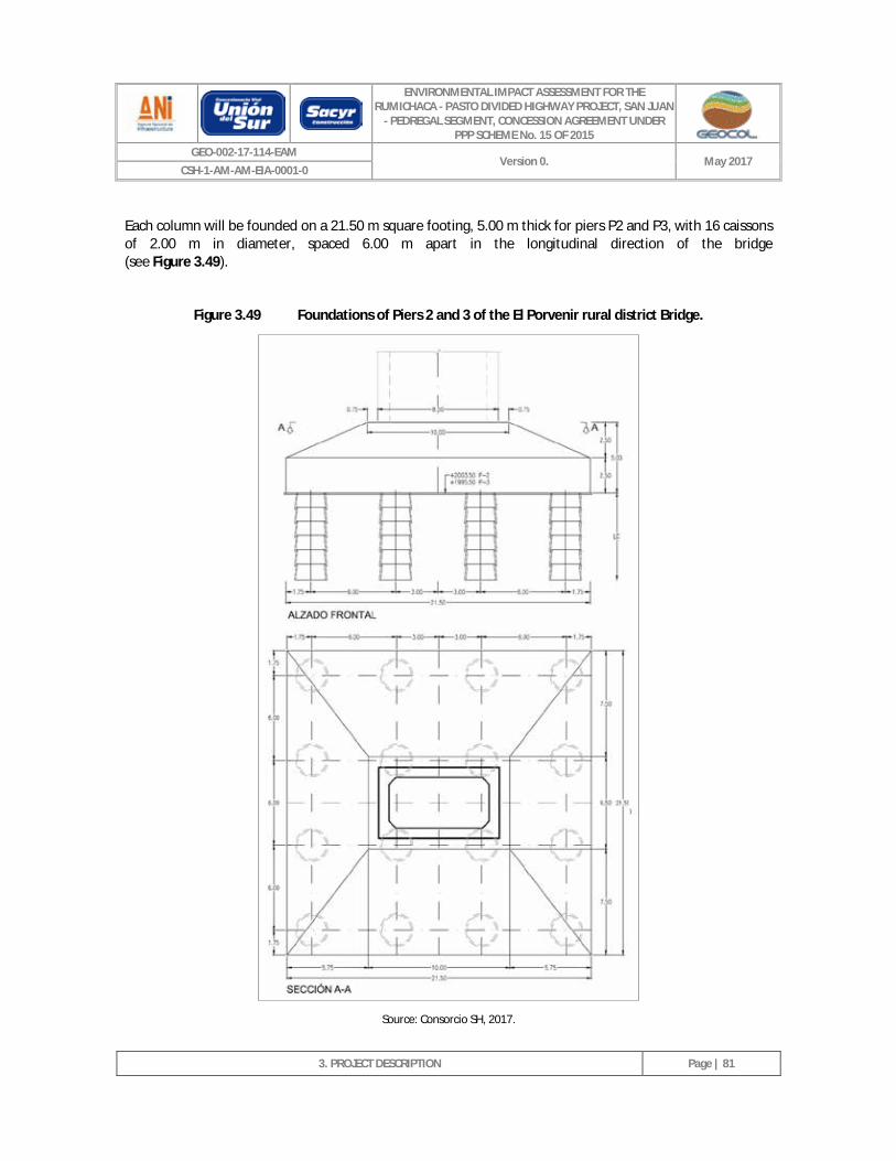
ENVIRONMENTAL IMPACT ASSESSMENT FOR THE RUMICHACA - PASTO DIVIDED HIGHWAY PROJECT, SAN JUAN
- PEDREGAL SEGMENT, CONCESSION AGREEMENT UNDER PPP SCHEME No. 15 OF 2015
GEO-002-17-114-EAM Version 0. May 2017
CSH-1-AM-AM-EIA-0001-0
3. PROJECT DESCRIPTION
Page | 81
Each column will be founded on a 21.50 m square footing, 5.00 m thick for piers P2 and P3, with 16 caissons of 2.00 m in diameter, spaced 6.00 m apart in the longitudinal direction of the bridge (see Figure 3.49).
Figure 3.49 Foundations of Piers 2 and 3 of the El Porvenir rural district Bridge.
Source: Consorcio SH, 2017.
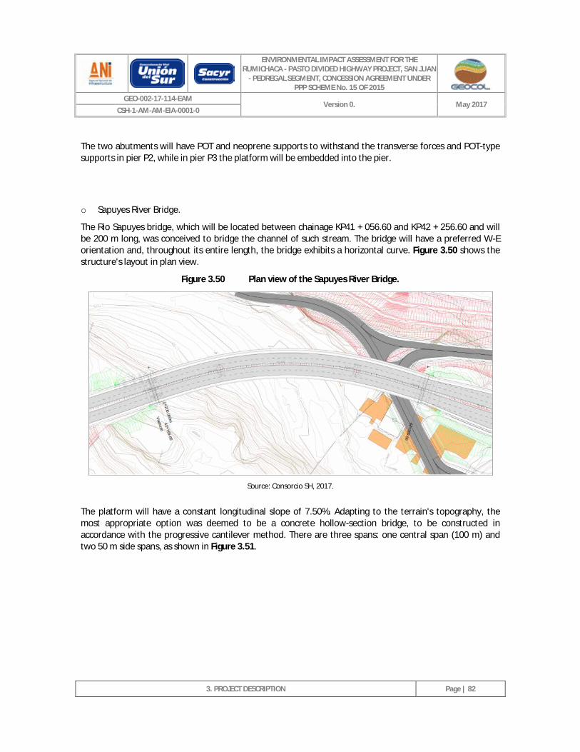
ENVIRONMENTAL IMPACT ASSESSMENT FOR THE RUMICHACA - PASTO DIVIDED HIGHWAY PROJECT, SAN JUAN
- PEDREGAL SEGMENT, CONCESSION AGREEMENT UNDER PPP SCHEME No. 15 OF 2015
GEO-002-17-114-EAM Version 0. May 2017
CSH-1-AM-AM-EIA-0001-0
3. PROJECT DESCRIPTION
Page | 82
The two abutments will have POT and neoprene supports to withstand the transverse forces and POT-type supports in pier P2, while in pier P3 the platform will be embedded into the pier.
o Sapuyes River Bridge.
The Rio Sapuyes bridge, which will be located between chainage KP41 + 056.60 and KP42 + 256.60 and will be 200 m long, was conceived to bridge the channel of such stream. The bridge will have a preferred W-E orientation and, throughout its entire length, the bridge exhibits a horizontal curve. Figure 3.50 shows the structure's layout in plan view.
Figure 3.50 Plan view of the Sapuyes River Bridge.
Source: Consorcio SH, 2017.
The platform will have a constant longitudinal slope of 7.50%. Adapting to the terrain's topography, the most appropriate option was deemed to be a concrete hollow-section bridge, to be constructed in accordance with the progressive cantilever method. There are three spans: one central span (100 m) and two 50 m side spans, as shown in Figure 3.51.
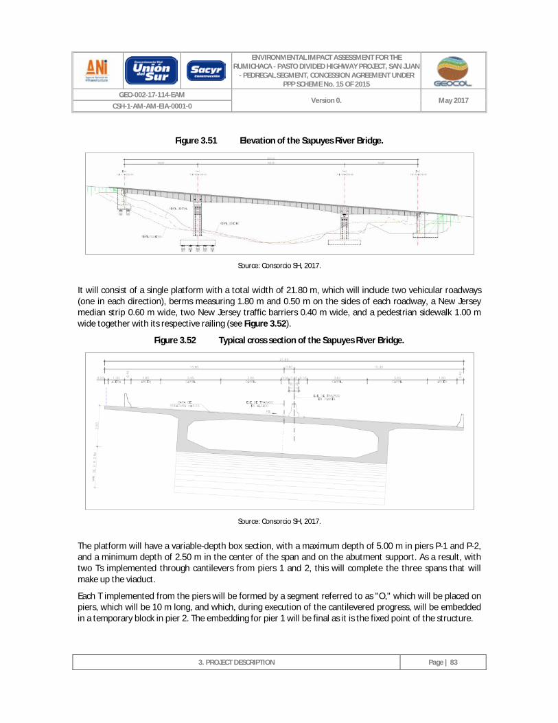
ENVIRONMENTAL IMPACT ASSESSMENT FOR THE RUMICHACA - PASTO DIVIDED HIGHWAY PROJECT, SAN JUAN
- PEDREGAL SEGMENT, CONCESSION AGREEMENT UNDER PPP SCHEME No. 15 OF 2015
GEO-002-17-114-EAM Version 0. May 2017
CSH-1-AM-AM-EIA-0001-0
3. PROJECT DESCRIPTION
Page | 83
Figure 3.51 Elevation of the Sapuyes River Bridge.
Source: Consorcio SH, 2017.
It will consist of a single platform with a total width of 21.80 m, which will include two vehicular roadways (one in each direction), berms measuring 1.80 m and 0.50 m on the sides of each roadway, a New Jersey median strip 0.60 m wide, two New Jersey traffic barriers 0.40 m wide, and a pedestrian sidewalk 1.00 m wide together with its respective railing (see Figure 3.52).
Figure 3.52 Typical cross section of the Sapuyes River Bridge.
Source: Consorcio SH, 2017.
The platform will have a variable-depth box section, with a maximum depth of 5.00 m in piers P-1 and P-2, and a minimum depth of 2.50 m in the center of the span and on the abutment support. As a result, with two Ts implemented through cantilevers from piers 1 and 2, this will complete the three spans that will make up the viaduct.
Each T implemented from the piers will be formed by a segment referred to as "O," which will be placed on piers, which will be 10 m long, and which, during execution of the cantilevered progress, will be embedded in a temporary block in pier 2. The embedding for pier 1 will be final as it is the fixed point of the structure.
ENVIRONMENTAL IMPACT ASSESSMENT FOR THE RUMICHACA - PASTO DIVIDED HIGHWAY PROJECT, SAN JUAN
- PEDREGAL SEGMENT, CONCESSION AGREEMENT UNDER PPP SCHEME No. 15 OF 2015
GEO-002-17-114-EAM Version 0. May 2017
CSH-1-AM-AM-EIA-0001-0
3. PROJECT DESCRIPTION
Page | 84
The box section will have webs with a constant thickness of 0.60 m. The base of the section's core will have a constant width of 12.80 m. The thickness of the lower platform has been projected at 0.6 m, on piers varying linearly up to 0.25 m. The webs' intersection with the upper slab of the platform will have haunches of a certain thickness, necessary so that the segment's tendons can be suitably anchored.
The pre-stressing of the segments (pre-stressed type A) will consist of twelve 29 T15 tendons per web. All tendons will be anchored on each segment front. The continuity pre-stressing (pre-stressed type B) will consist of six 31T15 tendons per web. Span 1 and span 3's pre-stressing will consist of two 19T15 tendons per web (pre-stressed type C).
The platform will rest on Pier 2 and on the abutments on neoprene-teflon devices (POT), while Pier 1 will be embedded since, as has already been mentioned, it will constitute the fixed point of the structure.
The piers will be made of reinforced concrete and will be rectangular in shape. Both piers will be hollow, and their dimensions will be 8.5 x 5.0 m, with a thickness of 0.80 m (see Figure 3.53).
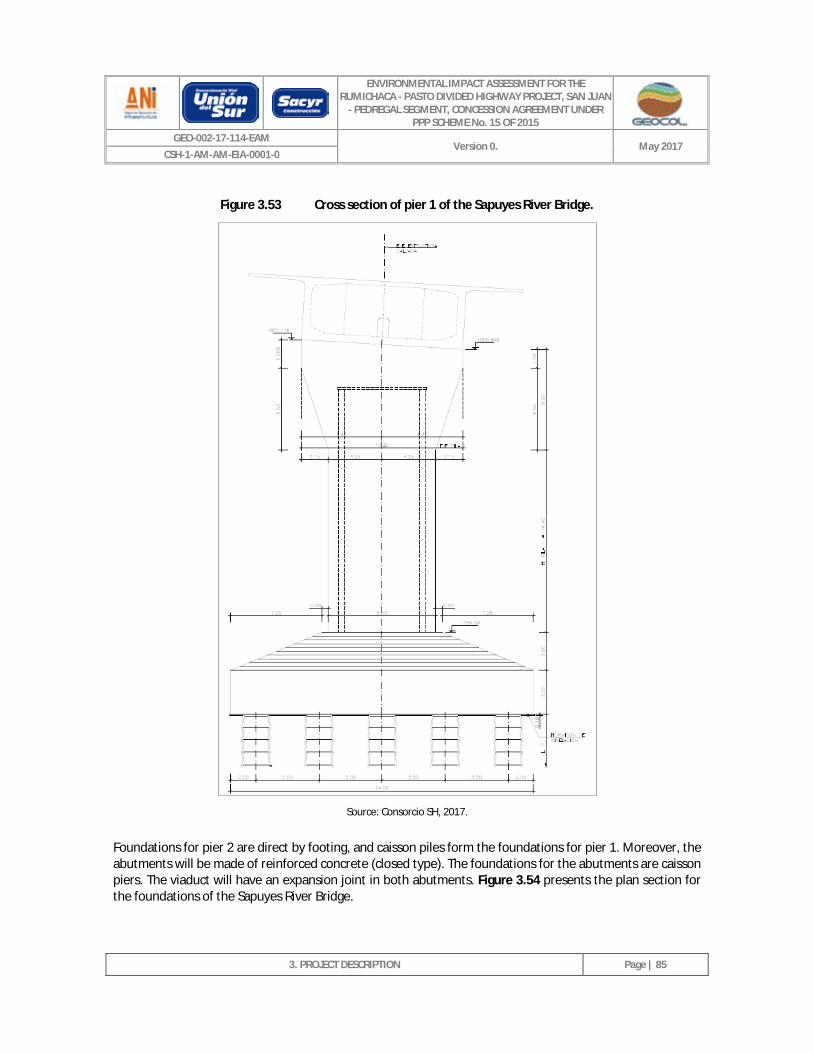
ENVIRONMENTAL IMPACT ASSESSMENT FOR THE RUMICHACA - PASTO DIVIDED HIGHWAY PROJECT, SAN JUAN
- PEDREGAL SEGMENT, CONCESSION AGREEMENT UNDER PPP SCHEME No. 15 OF 2015
GEO-002-17-114-EAM Version 0. May 2017
CSH-1-AM-AM-EIA-0001-0
3. PROJECT DESCRIPTION
Page | 85
Figure 3.53 Cross section of pier 1 of the Sapuyes River Bridge.
Source: Consorcio SH, 2017.
Foundations for pier 2 are direct by footing, and caisson piles form the foundations for pier 1. Moreover, the abutments will be made of reinforced concrete (closed type). The foundations for the abutments are caisson piers. The viaduct will have an expansion joint in both abutments. Figure 3.54 presents the plan section for the foundations of the Sapuyes River Bridge.
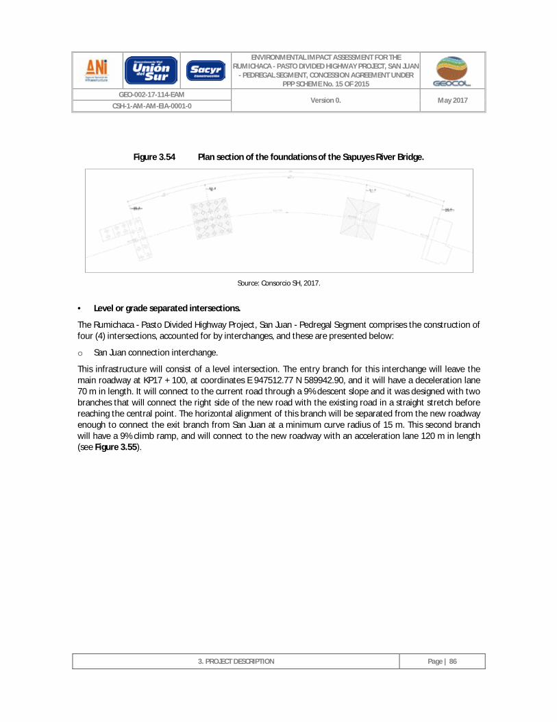
ENVIRONMENTAL IMPACT ASSESSMENT FOR THE RUMICHACA - PASTO DIVIDED HIGHWAY PROJECT, SAN JUAN
- PEDREGAL SEGMENT, CONCESSION AGREEMENT UNDER PPP SCHEME No. 15 OF 2015
GEO-002-17-114-EAM Version 0. May 2017
CSH-1-AM-AM-EIA-0001-0
3. PROJECT DESCRIPTION
Page | 86
Figure 3.54 Plan section of the foundations of the Sapuyes River Bridge.
Source: Consorcio SH, 2017.
· Level or grade separated intersections.
The Rumichaca - Pasto Divided Highway Project, San Juan - Pedregal Segment comprises the construction of four (4) intersections, accounted for by interchanges, and these are presented below:
o San Juan connection interchange.
This infrastructure will consist of a level intersection. The entry branch for this interchange will leave the main roadway at KP17 + 100, at coordinates E 947512.77 N 589942.90, and it will have a deceleration lane 70 m in length. It will connect to the current road through a 9% descent slope and it was designed with two branches that will connect the right side of the new road with the existing road in a straight stretch before reaching the central point. The horizontal alignment of this branch will be separated from the new roadway enough to connect the exit branch from San Juan at a minimum curve radius of 15 m. This second branch will have a 9% climb ramp, and will connect to the new roadway with an acceleration lane 120 m in length (see Figure 3.55).
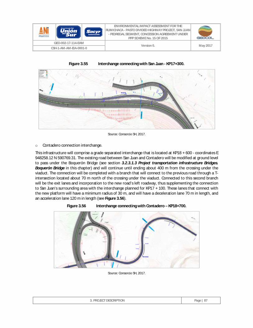
ENVIRONMENTAL IMPACT ASSESSMENT FOR THE RUMICHACA - PASTO DIVIDED HIGHWAY PROJECT, SAN JUAN
- PEDREGAL SEGMENT, CONCESSION AGREEMENT UNDER PPP SCHEME No. 15 OF 2015
GEO-002-17-114-EAM Version 0. May 2017
CSH-1-AM-AM-EIA-0001-0
3. PROJECT DESCRIPTION
Page | 87
Figure 3.55 Interchange connecting with San Juan - KP17+300.
Source: Consorcio SH, 2017.
o Contadero connection interchange.
This infrastructure will comprise a grade separated interchange that is located at KP18 + 600 - coordinates E 948258.12 N 590769.31. The existing road between San Juan and Contadero will be modified at ground level to pass under the Boquerón Bridge (see section 3.2.3.1.3 Project transportation infrastructure Bridges. Boquerón Bridge in this chapter) and will continue until ending about 400 m from the crossing under the viaduct. The connection will be completed with a branch that will connect to the previous road through a T-intersection located about 70 m north of the crossing under the viaduct. Connected to this second branch will be the exit lanes and incorporation to the new road’s left roadway, thus supplementing the connection to San Juan's surrounding area with the interchange planned for KP17 + 100. These lanes that connect with the new platform will have a minimum radius of 30 m, and will have a deceleration lane 70 m in length, and an acceleration lane 120 m in length (see Figure 3.56).
Figure 3.56 Interchange connecting with Contadero – KP18+700.
Source: Consorcio SH, 2017.
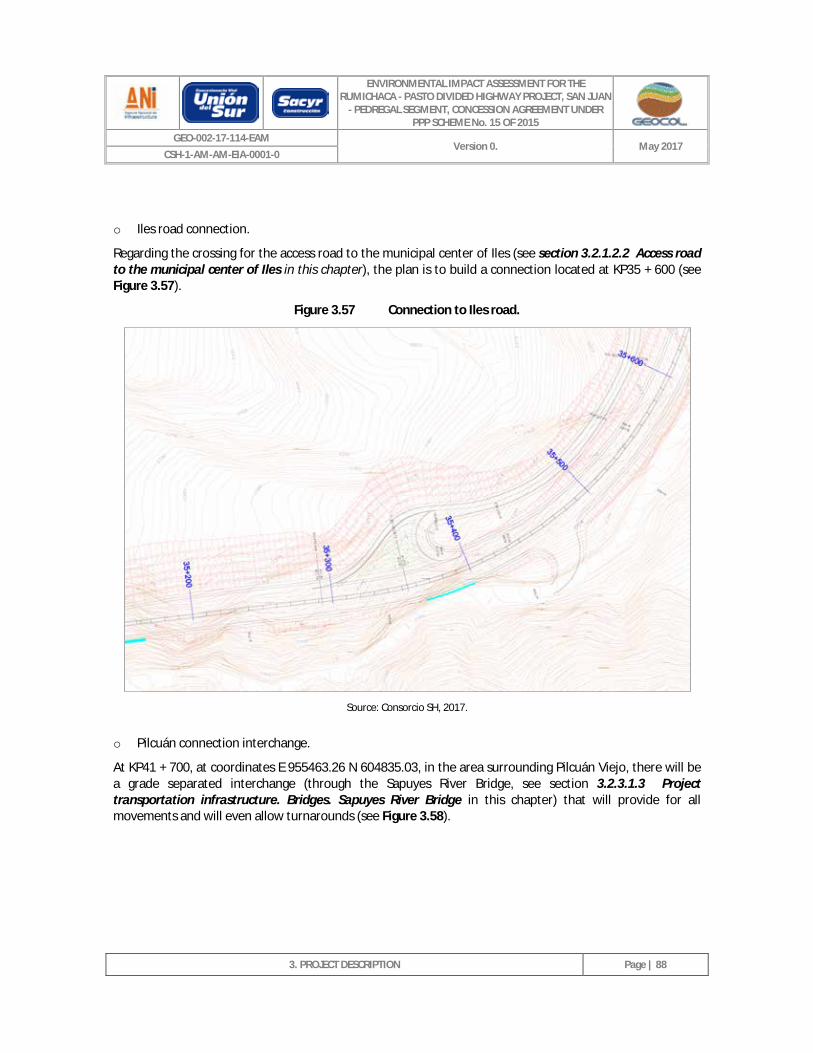
ENVIRONMENTAL IMPACT ASSESSMENT FOR THE RUMICHACA - PASTO DIVIDED HIGHWAY PROJECT, SAN JUAN
- PEDREGAL SEGMENT, CONCESSION AGREEMENT UNDER PPP SCHEME No. 15 OF 2015
GEO-002-17-114-EAM Version 0. May 2017
CSH-1-AM-AM-EIA-0001-0
3. PROJECT DESCRIPTION
Page | 88
o Iles road connection.
Regarding the crossing for the access road to the municipal center of Iles (see section 3.2.1.2.2 Access road to the municipal center of Iles in this chapter), the plan is to build a connection located at KP35 + 600 (see Figure 3.57).
Figure 3.57 Connection to Iles road.
Source: Consorcio SH, 2017.
o Pilcuán connection interchange.
At KP41 + 700, at coordinates E 955463.26 N 604835.03, in the area surrounding Pilcuán Viejo, there will be a grade separated interchange (through the Sapuyes River Bridge, see section 3.2.3.1.3 Project transportation infrastructure. Bridges. Sapuyes River Bridge in this chapter) that will provide for all movements and will even allow turnarounds (see Figure 3.58).
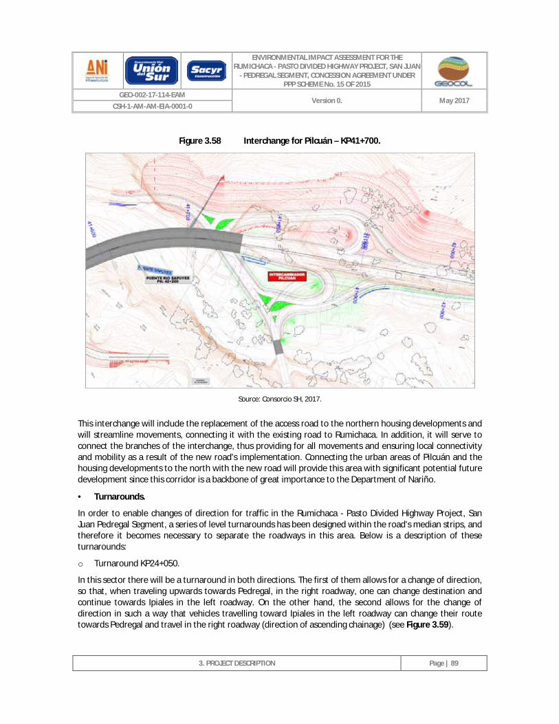
ENVIRONMENTAL IMPACT ASSESSMENT FOR THE RUMICHACA - PASTO DIVIDED HIGHWAY PROJECT, SAN JUAN
- PEDREGAL SEGMENT, CONCESSION AGREEMENT UNDER PPP SCHEME No. 15 OF 2015
GEO-002-17-114-EAM Version 0. May 2017
CSH-1-AM-AM-EIA-0001-0
3. PROJECT DESCRIPTION
Page | 89
Figure 3.58 Interchange for Pilcuán – KP41+700.
Source: Consorcio SH, 2017.
This interchange will include the replacement of the access road to the northern housing developments and will streamline movements, connecting it with the existing road to Rumichaca. In addition, it will serve to connect the branches of the interchange, thus providing for all movements and ensuring local connectivity and mobility as a result of the new road's implementation. Connecting the urban areas of Pilcuán and the housing developments to the north with the new road will provide this area with significant potential future development since this corridor is a backbone of great importance to the Department of Nariño.
· Turnarounds.
In order to enable changes of direction for traffic in the Rumichaca - Pasto Divided Highway Project, San Juan Pedregal Segment, a series of level turnarounds has been designed within the road's median strips, and therefore it becomes necessary to separate the roadways in this area. Below is a description of these turnarounds:
o Turnaround KP24+050.
In this sector there will be a turnaround in both directions. The first of them allows for a change of direction, so that, when traveling upwards towards Pedregal, in the right roadway, one can change destination and continue towards Ipiales in the left roadway. On the other hand, the second allows for the change of direction in such a way that vehicles travelling toward Ipiales in the left roadway can change their route towards Pedregal and travel in the right roadway (direction of ascending chainage) (see Figure 3.59).
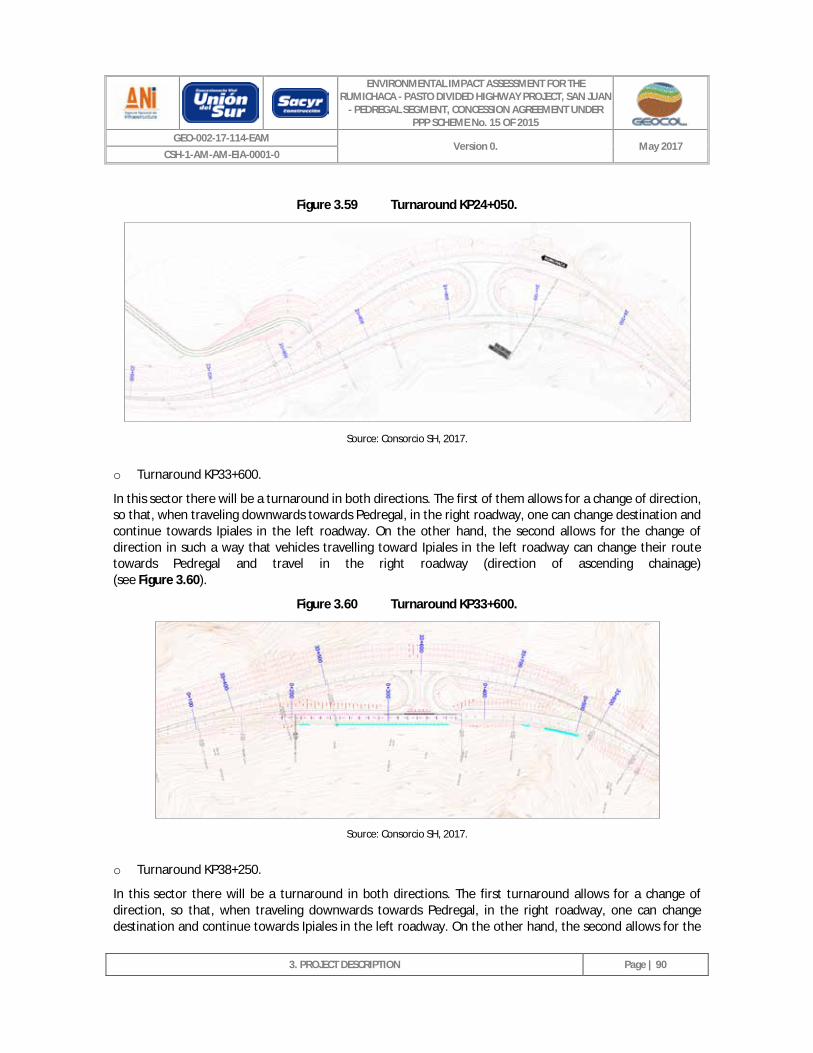
ENVIRONMENTAL IMPACT ASSESSMENT FOR THE RUMICHACA - PASTO DIVIDED HIGHWAY PROJECT, SAN JUAN
- PEDREGAL SEGMENT, CONCESSION AGREEMENT UNDER PPP SCHEME No. 15 OF 2015
GEO-002-17-114-EAM Version 0. May 2017
CSH-1-AM-AM-EIA-0001-0
3. PROJECT DESCRIPTION
Page | 90
Figure 3.59 Turnaround KP24+050.
Source: Consorcio SH, 2017.
o Turnaround KP33+600.
In this sector there will be a turnaround in both directions. The first of them allows for a change of direction, so that, when traveling downwards towards Pedregal, in the right roadway, one can change destination and continue towards Ipiales in the left roadway. On the other hand, the second allows for the change of direction in such a way that vehicles travelling toward Ipiales in the left roadway can change their route towards Pedregal and travel in the right roadway (direction of ascending chainage) (see Figure 3.60).
Figure 3.60 Turnaround KP33+600.
Source: Consorcio SH, 2017.
o Turnaround KP38+250.
In this sector there will be a turnaround in both directions. The first turnaround allows for a change of direction, so that, when traveling downwards towards Pedregal, in the right roadway, one can change destination and continue towards Ipiales in the left roadway. On the other hand, the second allows for the
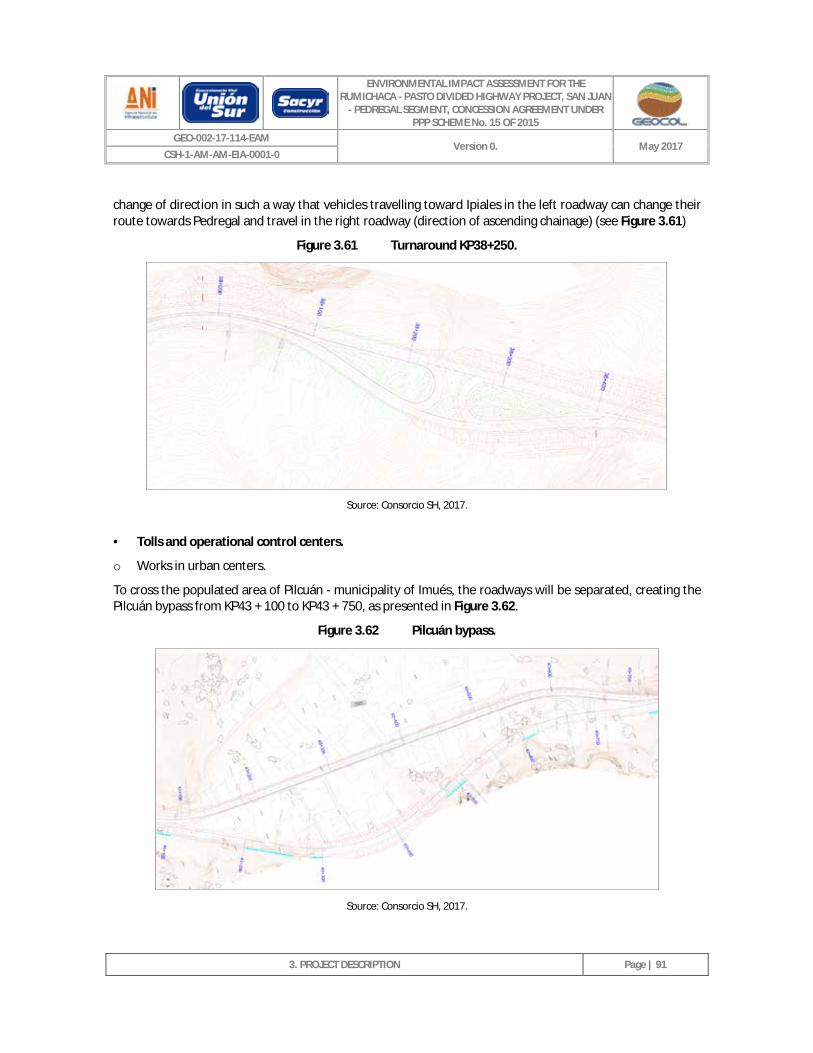
ENVIRONMENTAL IMPACT ASSESSMENT FOR THE RUMICHACA - PASTO DIVIDED HIGHWAY PROJECT, SAN JUAN
- PEDREGAL SEGMENT, CONCESSION AGREEMENT UNDER PPP SCHEME No. 15 OF 2015
GEO-002-17-114-EAM Version 0. May 2017
CSH-1-AM-AM-EIA-0001-0
3. PROJECT DESCRIPTION
Page | 91
change of direction in such a way that vehicles travelling toward Ipiales in the left roadway can change their route towards Pedregal and travel in the right roadway (direction of ascending chainage) (see Figure 3.61)
Figure 3.61 Turnaround KP38+250.
Source: Consorcio SH, 2017.
· Tolls and operational control centers.
o Works in urban centers.
To cross the populated area of Pilcuán - municipality of Imués, the roadways will be separated, creating the Pilcuán bypass from KP43 + 100 to KP43 + 750, as presented in Figure 3.62.
Figure 3.62 Pilcuán bypass.
Source: Consorcio SH, 2017.
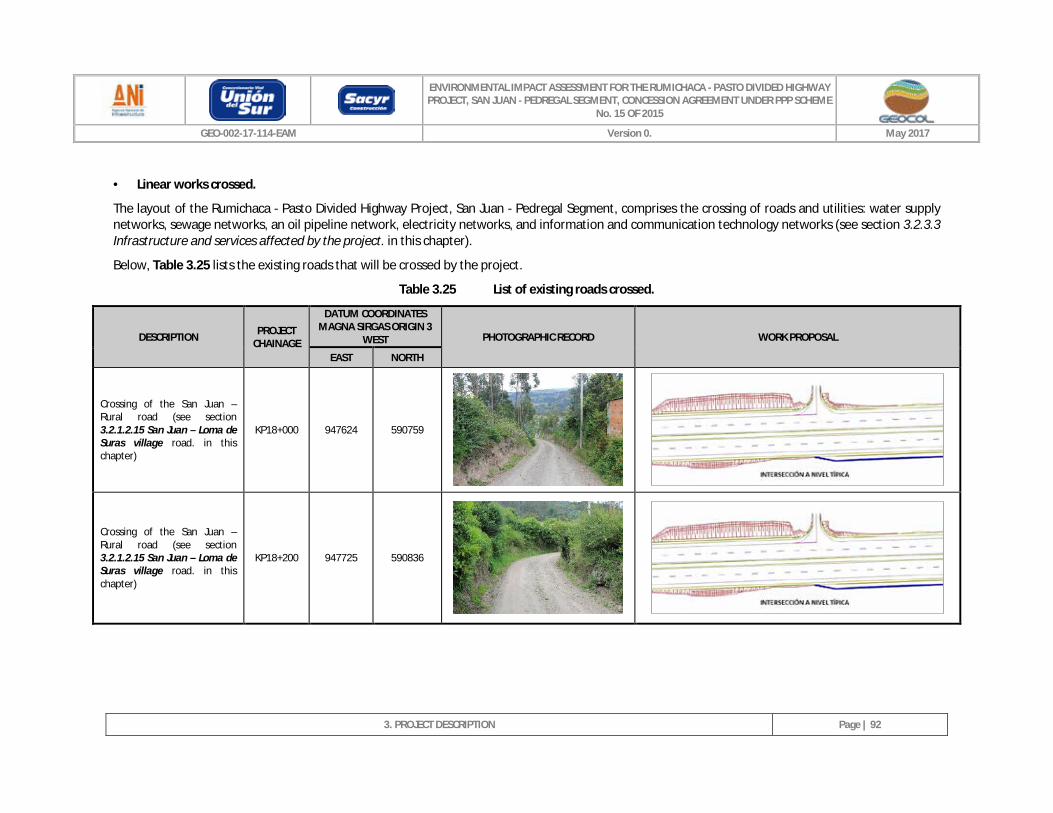
ENVIRONMENTAL IMPACT ASSESSMENT FOR THE RUMICHACA - PASTO DIVIDED HIGHWAY PROJECT, SAN JUAN - PEDREGAL SEGMENT, CONCESSION AGREEMENT UNDER PPP SCHEME
No. 15 OF 2015
GEO-002-17-114-EAM Version 0. May 2017
3. PROJECT DESCRIPTION
Page | 92
· Linear works crossed.
The layout of the Rumichaca - Pasto Divided Highway Project, San Juan - Pedregal Segment, comprises the crossing of roads and utilities: water supply networks, sewage networks, an oil pipeline network, electricity networks, and information and communication technology networks (see section 3.2.3.3 Infrastructure and services affected by the project. in this chapter).
Below, Table 3.25 lists the existing roads that will be crossed by the project.
Table 3.25 List of existing roads crossed.
DESCRIPTION PROJECT CHAINAGE
DATUM COORDINATES MAGNA SIRGAS ORIGIN 3
WEST PHOTOGRAPHIC RECORD WORK PROPOSAL
EAST NORTH
Crossing of the San Juan – Rural road (see section 3.2.1.2.15 San Juan – Loma de Suras village road. in this chapter)
KP18+000 947624 590759
Crossing of the San Juan – Rural road (see section 3.2.1.2.15 San Juan – Loma de Suras village road. in this chapter)
KP18+200 947725 590836
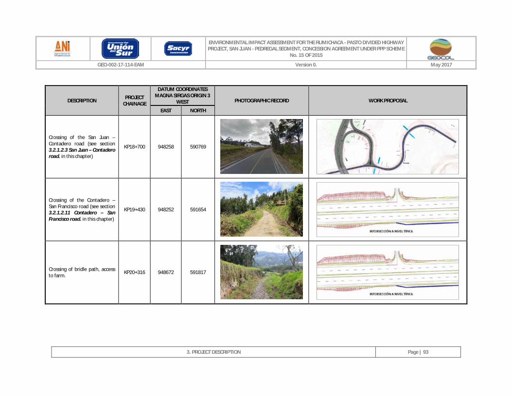
ENVIRONMENTAL IMPACT ASSESSMENT FOR THE RUMICHACA - PASTO DIVIDED HIGHWAY PROJECT, SAN JUAN - PEDREGAL SEGMENT, CONCESSION AGREEMENT UNDER PPP SCHEME
No. 15 OF 2015
GEO-002-17-114-EAM Version 0. May 2017
3. PROJECT DESCRIPTION
Page | 93
DESCRIPTION PROJECT CHAINAGE
DATUM COORDINATES MAGNA SIRGAS ORIGIN 3
WEST PHOTOGRAPHIC RECORD WORK PROPOSAL
EAST NORTH
Crossing of the San Juan – Contadero road (see section 3.2.1.2.3 San Juan – Contadero road. in this chapter)
KP18+700 948258 590769
Crossing of the Contadero – San Francisco road (see section 3.2.1.2.11 Contadero – San Francisco road. in this chapter)
KP19+430 948252 591654
Crossing of bridle path, access to farm. KP20+316 948672 591817
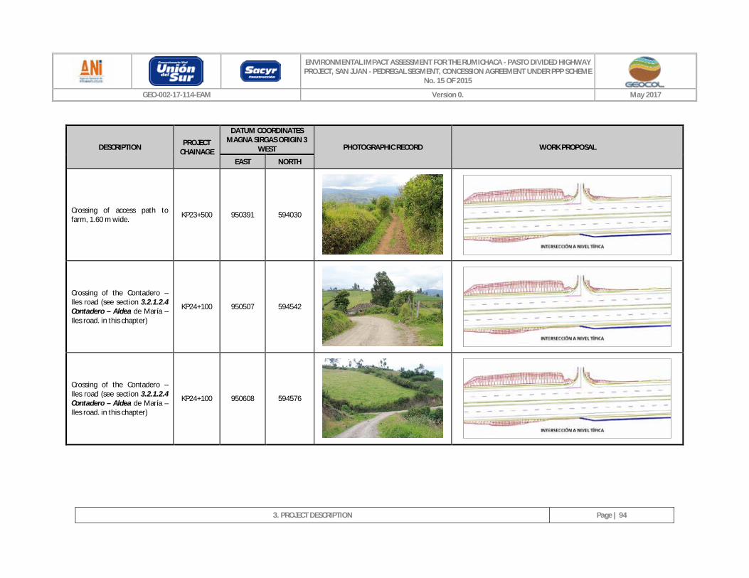
ENVIRONMENTAL IMPACT ASSESSMENT FOR THE RUMICHACA - PASTO DIVIDED HIGHWAY PROJECT, SAN JUAN - PEDREGAL SEGMENT, CONCESSION AGREEMENT UNDER PPP SCHEME
No. 15 OF 2015
GEO-002-17-114-EAM Version 0. May 2017
3. PROJECT DESCRIPTION
Page | 94
DESCRIPTION PROJECT CHAINAGE
DATUM COORDINATES MAGNA SIRGAS ORIGIN 3
WEST PHOTOGRAPHIC RECORD WORK PROPOSAL
EAST NORTH
Crossing of access path to farm, 1.60 m wide. KP23+500 950391 594030
Crossing of the Contadero – Iles road (see section 3.2.1.2.4 Contadero – Aldea de María – Iles road. in this chapter)
KP24+100 950507 594542
Crossing of the Contadero – Iles road (see section 3.2.1.2.4 Contadero – Aldea de María – Iles road. in this chapter)
KP24+100 950608 594576
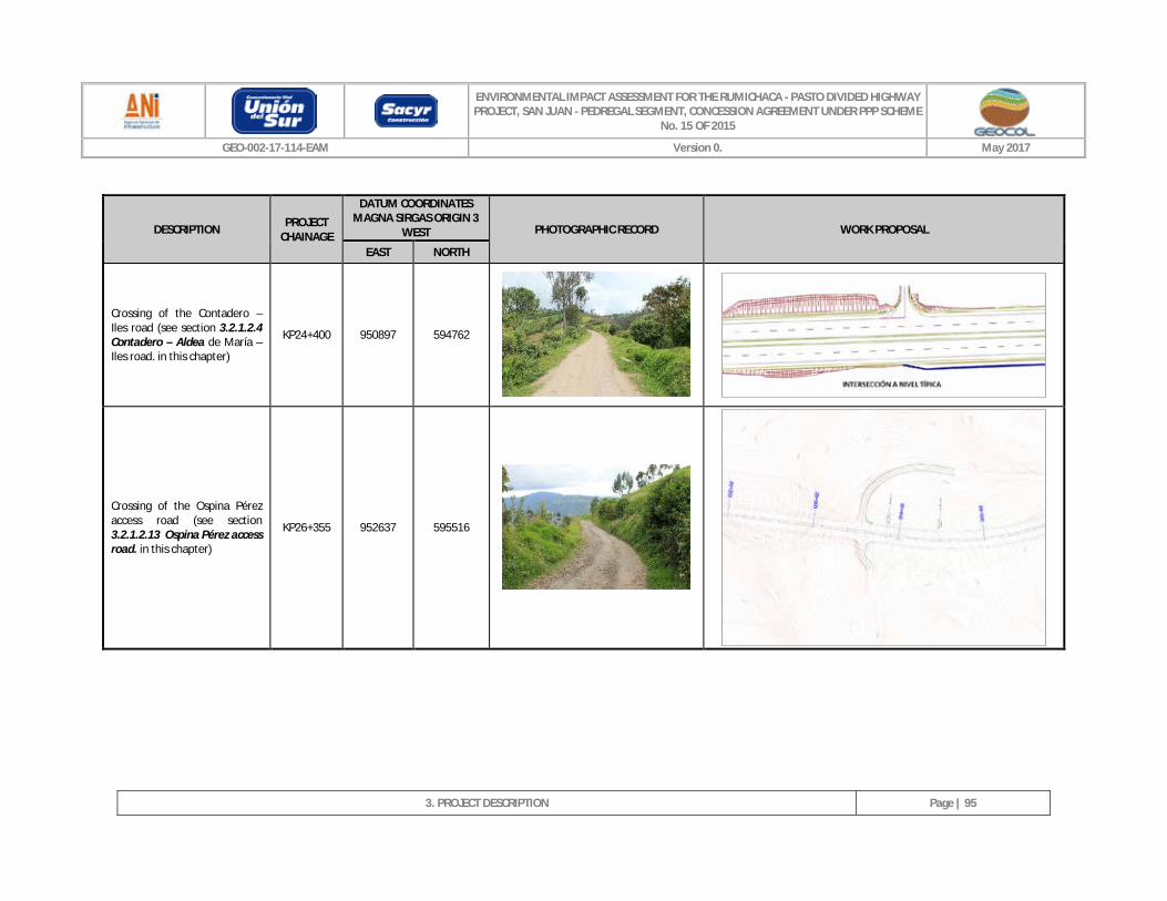
ENVIRONMENTAL IMPACT ASSESSMENT FOR THE RUMICHACA - PASTO DIVIDED HIGHWAY PROJECT, SAN JUAN - PEDREGAL SEGMENT, CONCESSION AGREEMENT UNDER PPP SCHEME
No. 15 OF 2015
GEO-002-17-114-EAM Version 0. May 2017
3. PROJECT DESCRIPTION
Page | 95
DESCRIPTION PROJECT CHAINAGE
DATUM COORDINATES MAGNA SIRGAS ORIGIN 3
WEST PHOTOGRAPHIC RECORD WORK PROPOSAL
EAST NORTH
Crossing of the Contadero – Iles road (see section 3.2.1.2.4 Contadero – Aldea de María – Iles road. in this chapter)
KP24+400 950897 594762
Crossing of the Ospina Pérez access road (see section 3.2.1.2.13 Ospina Pérez access road. in this chapter)
KP26+355 952637 595516
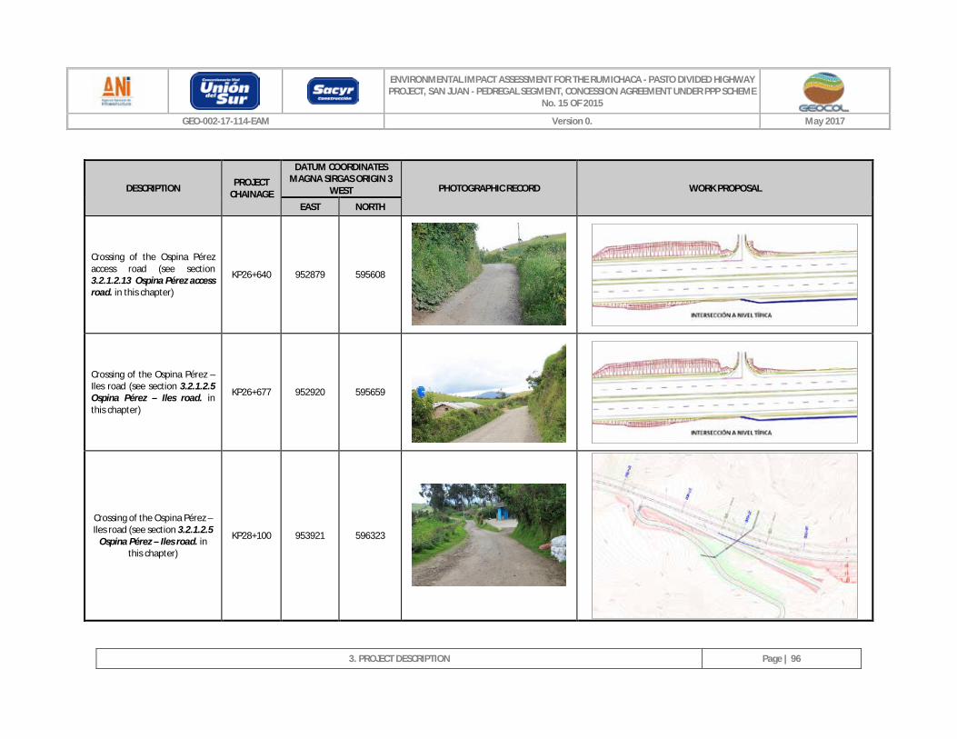
ENVIRONMENTAL IMPACT ASSESSMENT FOR THE RUMICHACA - PASTO DIVIDED HIGHWAY PROJECT, SAN JUAN - PEDREGAL SEGMENT, CONCESSION AGREEMENT UNDER PPP SCHEME
No. 15 OF 2015
GEO-002-17-114-EAM Version 0. May 2017
3. PROJECT DESCRIPTION
Page | 96
DESCRIPTION PROJECT CHAINAGE
DATUM COORDINATES MAGNA SIRGAS ORIGIN 3
WEST PHOTOGRAPHIC RECORD WORK PROPOSAL
EAST NORTH
Crossing of the Ospina Pérez access road (see section 3.2.1.2.13 Ospina Pérez access road. in this chapter)
KP26+640 952879 595608
Crossing of the Ospina Pérez – Iles road (see section 3.2.1.2.5 Ospina Pérez – Iles road. in this chapter)
KP26+677 952920 595659
Crossing of the Ospina Pérez – Iles road (see section 3.2.1.2.5
Ospina Pérez – Iles road. in this chapter)
KP28+100 953921 596323
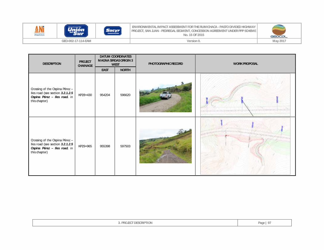
ENVIRONMENTAL IMPACT ASSESSMENT FOR THE RUMICHACA - PASTO DIVIDED HIGHWAY PROJECT, SAN JUAN - PEDREGAL SEGMENT, CONCESSION AGREEMENT UNDER PPP SCHEME
No. 15 OF 2015
GEO-002-17-114-EAM Version 0. May 2017
3. PROJECT DESCRIPTION
Page | 97
DESCRIPTION PROJECT CHAINAGE
DATUM COORDINATES MAGNA SIRGAS ORIGIN 3
WEST PHOTOGRAPHIC RECORD WORK PROPOSAL
EAST NORTH
Crossing of the Ospina Pérez – Iles road (see section 3.2.1.2.5 Ospina Pérez – Iles road. in this chapter)
KP28+430 954204 596620
Crossing of the Ospina Pérez – Iles road (see section 3.2.1.2.5 Ospina Pérez – Iles road. in this chapter)
KP29+965 955398 597503
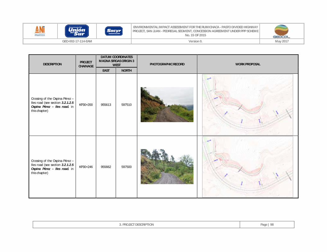
ENVIRONMENTAL IMPACT ASSESSMENT FOR THE RUMICHACA - PASTO DIVIDED HIGHWAY PROJECT, SAN JUAN - PEDREGAL SEGMENT, CONCESSION AGREEMENT UNDER PPP SCHEME
No. 15 OF 2015
GEO-002-17-114-EAM Version 0. May 2017
3. PROJECT DESCRIPTION
Page | 98
DESCRIPTION PROJECT CHAINAGE
DATUM COORDINATES MAGNA SIRGAS ORIGIN 3
WEST PHOTOGRAPHIC RECORD WORK PROPOSAL
EAST NORTH
Crossing of the Ospina Pérez – Iles road (see section 3.2.1.2.5 Ospina Pérez – Iles road. in this chapter)
KP30+200 955613 597510
Crossing of the Ospina Pérez – Iles road (see section 3.2.1.2.5 Ospina Pérez – Iles road. in this chapter)
KP30+246 955662 597500
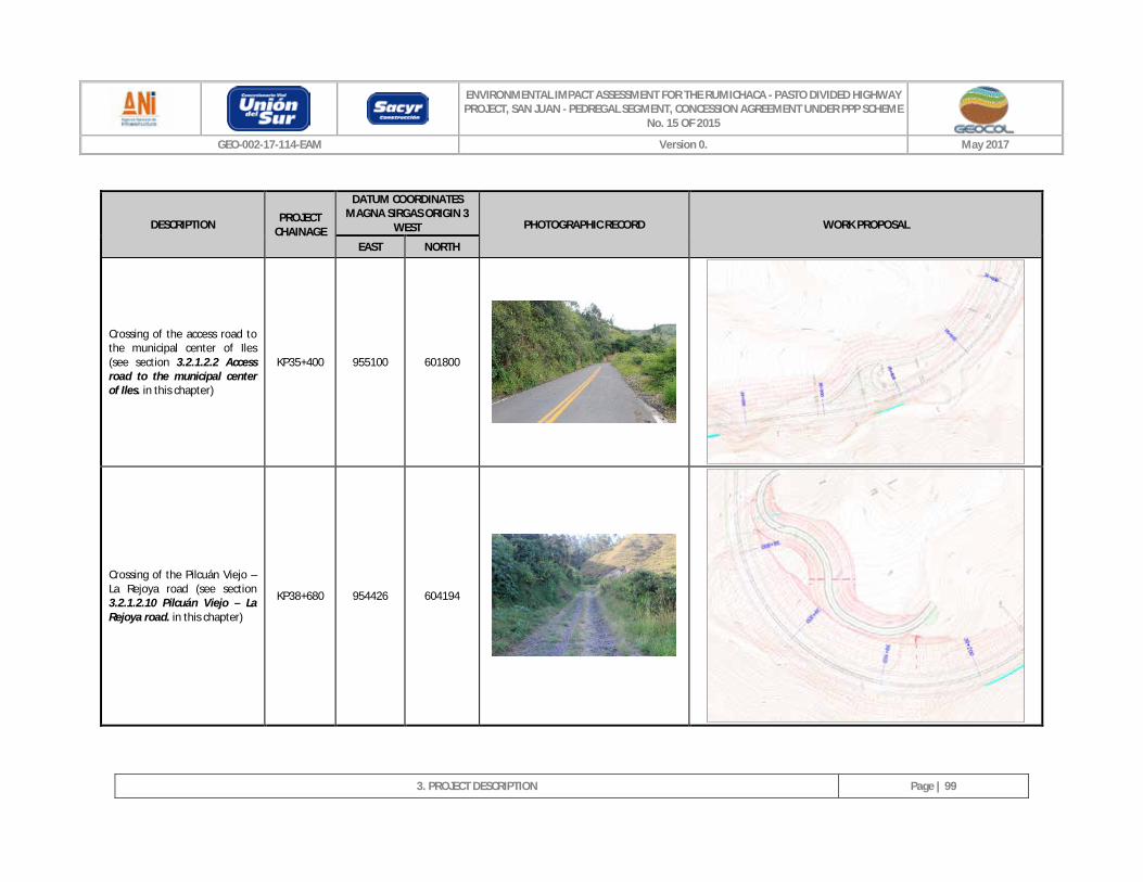
ENVIRONMENTAL IMPACT ASSESSMENT FOR THE RUMICHACA - PASTO DIVIDED HIGHWAY PROJECT, SAN JUAN - PEDREGAL SEGMENT, CONCESSION AGREEMENT UNDER PPP SCHEME
No. 15 OF 2015
GEO-002-17-114-EAM Version 0. May 2017
3. PROJECT DESCRIPTION
Page | 99
DESCRIPTION PROJECT CHAINAGE
DATUM COORDINATES MAGNA SIRGAS ORIGIN 3
WEST PHOTOGRAPHIC RECORD WORK PROPOSAL
EAST NORTH
Crossing of the access road to the municipal center of Iles (see section 3.2.1.2.2 Access road to the municipal center of Iles. in this chapter)
KP35+400 955100 601800
Crossing of the Pilcuán Viejo – La Rejoya road (see section 3.2.1.2.10 Pilcuán Viejo – La Rejoya road. in this chapter)
KP38+680 954426 604194
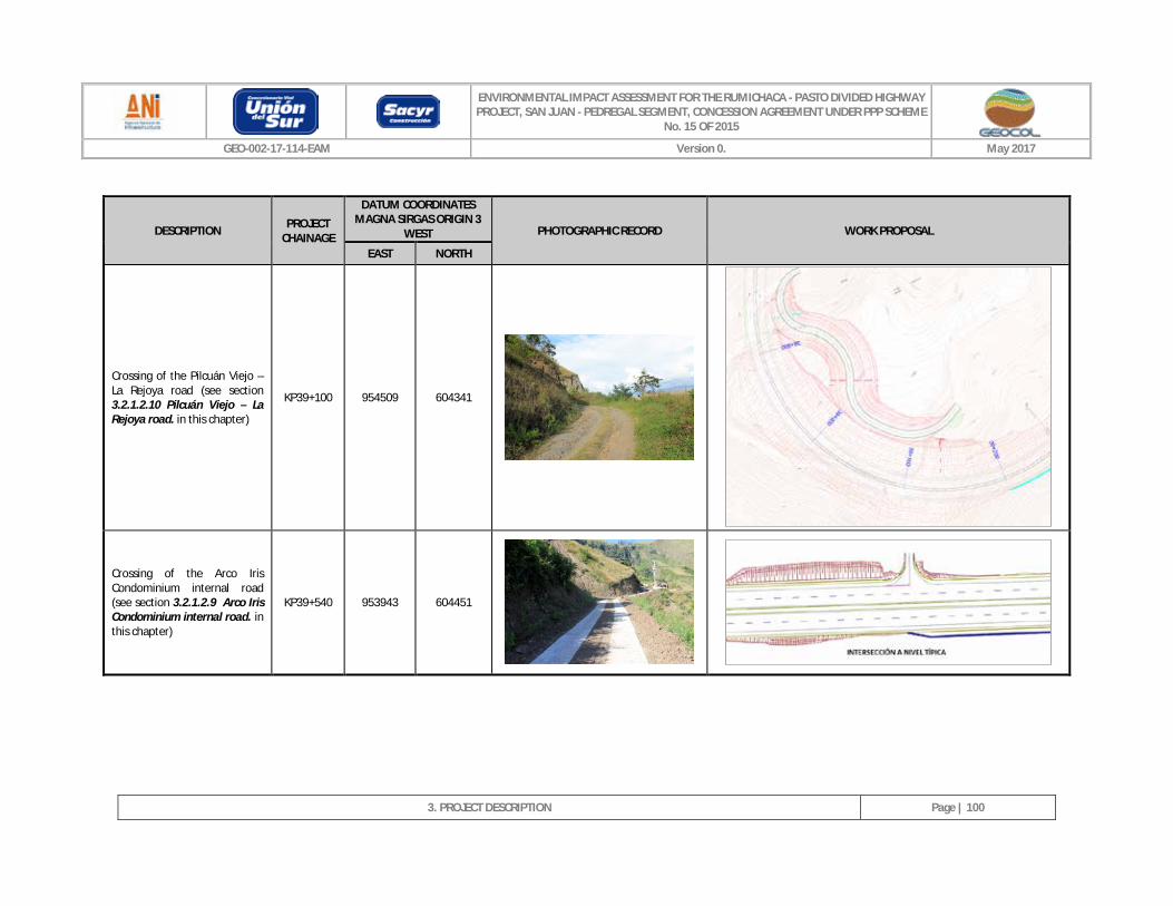
ENVIRONMENTAL IMPACT ASSESSMENT FOR THE RUMICHACA - PASTO DIVIDED HIGHWAY PROJECT, SAN JUAN - PEDREGAL SEGMENT, CONCESSION AGREEMENT UNDER PPP SCHEME
No. 15 OF 2015
GEO-002-17-114-EAM Version 0. May 2017
3. PROJECT DESCRIPTION
Page | 100
DESCRIPTION PROJECT CHAINAGE
DATUM COORDINATES MAGNA SIRGAS ORIGIN 3
WEST PHOTOGRAPHIC RECORD WORK PROPOSAL
EAST NORTH
Crossing of the Pilcuán Viejo – La Rejoya road (see section 3.2.1.2.10 Pilcuán Viejo – La Rejoya road. in this chapter)
KP39+100 954509 604341
Crossing of the Arco Iris Condominium internal road (see section 3.2.1.2.9 Arco Iris Condominium internal road. in this chapter)
KP39+540 953943 604451
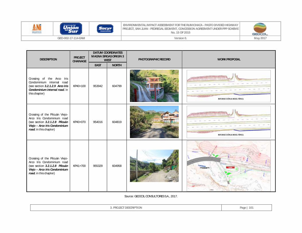
ENVIRONMENTAL IMPACT ASSESSMENT FOR THE RUMICHACA - PASTO DIVIDED HIGHWAY PROJECT, SAN JUAN - PEDREGAL SEGMENT, CONCESSION AGREEMENT UNDER PPP SCHEME
No. 15 OF 2015
GEO-002-17-114-EAM Version 0. May 2017
3. PROJECT DESCRIPTION
Page | 101
DESCRIPTION PROJECT CHAINAGE
DATUM COORDINATES MAGNA SIRGAS ORIGIN 3
WEST PHOTOGRAPHIC RECORD WORK PROPOSAL
EAST NORTH
Crossing of the Arco Iris Condominium internal road (see section 3.2.1.2.9 Arco Iris Condominium internal road. in this chapter)
KP40+100 953942 604799
Crossing of the Pilcuán Viejo- Arco Iris Condominium road (see section 3.2.1.2.8 Pilcuán Viejo – Arco Iris Condominium road. in this chapter)
KP40+070 954016 604819
Crossing of the Pilcuán Viejo- Arco Iris Condominium road (see section 3.2.1.2.8 Pilcuán Viejo – Arco Iris Condominium road. in this chapter)
KP41+700 955329 604958
Source: GEOCOL CONSULTORES S.A., 2017.
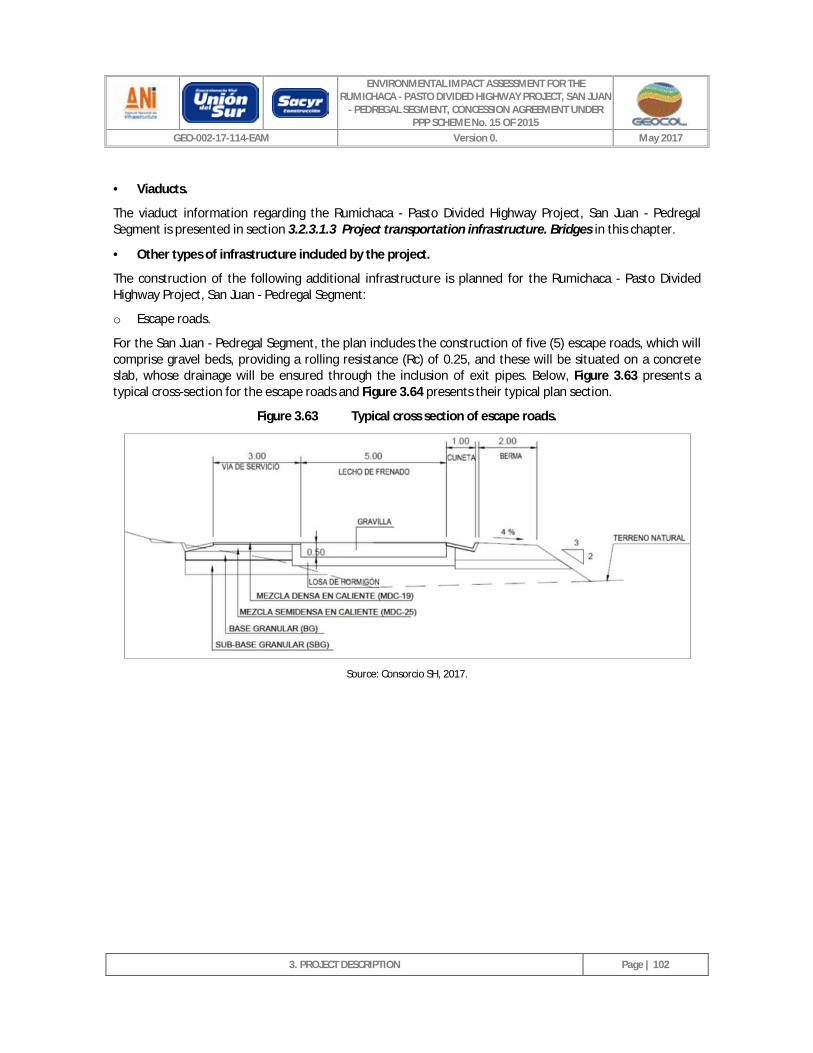
ENVIRONMENTAL IMPACT ASSESSMENT FOR THE RUMICHACA - PASTO DIVIDED HIGHWAY PROJECT, SAN JUAN
- PEDREGAL SEGMENT, CONCESSION AGREEMENT UNDER PPP SCHEME No. 15 OF 2015
GEO-002-17-114-EAM Version 0. May 2017
3. PROJECT DESCRIPTION
Page | 102
· Viaducts.
The viaduct information regarding the Rumichaca - Pasto Divided Highway Project, San Juan - Pedregal Segment is presented in section 3.2.3.1.3 Project transportation infrastructure. Bridges in this chapter.
· Other types of infrastructure included by the project.
The construction of the following additional infrastructure is planned for the Rumichaca - Pasto Divided Highway Project, San Juan - Pedregal Segment:
o Escape roads.
For the San Juan - Pedregal Segment, the plan includes the construction of five (5) escape roads, which will comprise gravel beds, providing a rolling resistance (Rc) of 0.25, and these will be situated on a concrete slab, whose drainage will be ensured through the inclusion of exit pipes. Below, Figure 3.63 presents a typical cross-section for the escape roads and Figure 3.64 presents their typical plan section.
Figure 3.63 Typical cross section of escape roads.
Source: Consorcio SH, 2017.
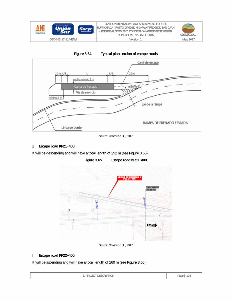
ENVIRONMENTAL IMPACT ASSESSMENT FOR THE RUMICHACA - PASTO DIVIDED HIGHWAY PROJECT, SAN JUAN
- PEDREGAL SEGMENT, CONCESSION AGREEMENT UNDER PPP SCHEME No. 15 OF 2015
GEO-002-17-114-EAM Version 0. May 2017
3. PROJECT DESCRIPTION
Page | 103
Figure 3.64 Typical plan section of escape roads.
Source: Consorcio SH, 2017.
§ Escape road KP21+400.
It will be descending and will have a total length of 292 m (see Figure 3.65).
Figure 3.65 Escape road KP21+400.
Source: Consorcio SH, 2017.
§ Escape road KP22+400.
It will be ascending and will have a total length of 260 m (see Figure 3.66).
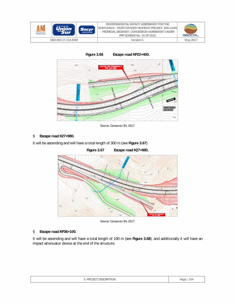
ENVIRONMENTAL IMPACT ASSESSMENT FOR THE RUMICHACA - PASTO DIVIDED HIGHWAY PROJECT, SAN JUAN
- PEDREGAL SEGMENT, CONCESSION AGREEMENT UNDER PPP SCHEME No. 15 OF 2015
GEO-002-17-114-EAM Version 0. May 2017
3. PROJECT DESCRIPTION
Page | 104
Figure 3.66 Escape road KP22+400.
Source: Consorcio SH, 2017.
§ Escape road K27+980.
It will be ascending and will have a total length of 300 m (see Figure 3.67).
Figure 3.67 Escape road K27+980.
Source: Consorcio SH, 2017.
§ Escape road KP36+100.
It will be ascending and will have a total length of 190 m (see Figure 3.68), and additionally it will have an impact attenuator device at the end of the structure.
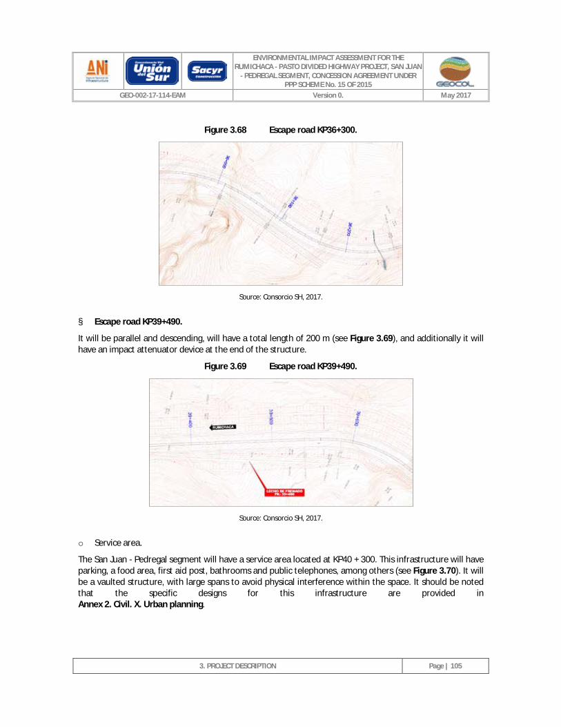
ENVIRONMENTAL IMPACT ASSESSMENT FOR THE RUMICHACA - PASTO DIVIDED HIGHWAY PROJECT, SAN JUAN
- PEDREGAL SEGMENT, CONCESSION AGREEMENT UNDER PPP SCHEME No. 15 OF 2015
GEO-002-17-114-EAM Version 0. May 2017
3. PROJECT DESCRIPTION
Page | 105
Figure 3.68 Escape road KP36+300.
Source: Consorcio SH, 2017.
§ Escape road KP39+490.
It will be parallel and descending, will have a total length of 200 m (see Figure 3.69), and additionally it will have an impact attenuator device at the end of the structure.
Figure 3.69 Escape road KP39+490.
Source: Consorcio SH, 2017.
o Service area.
The San Juan - Pedregal segment will have a service area located at KP40 + 300. This infrastructure will have parking, a food area, first aid post, bathrooms and public telephones, among others (see Figure 3.70). It will be a vaulted structure, with large spans to avoid physical interference within the space. It should be noted that the specific designs for this infrastructure are provided in Annex 2. Civil. X. Urban planning.
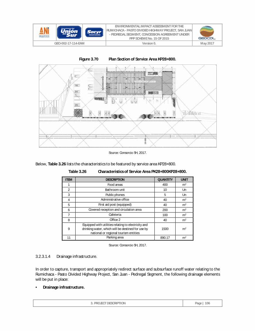
ENVIRONMENTAL IMPACT ASSESSMENT FOR THE RUMICHACA - PASTO DIVIDED HIGHWAY PROJECT, SAN JUAN
- PEDREGAL SEGMENT, CONCESSION AGREEMENT UNDER PPP SCHEME No. 15 OF 2015
GEO-002-17-114-EAM Version 0. May 2017
3. PROJECT DESCRIPTION
Page | 106
Figure 3.70 Plan Section of Service Area KP28+800.
Source: Consorcio SH, 2017.
Below, Table 3.26 lists the characteristics to be featured by service area KP28+800.
Table 3.26 Characteristics of Service Area PK28+800KP28+800.
ITEM DESCRIPTION QUANTITY UNIT 1 Food areas 400 m2 2 Bathroom unit 10 Un 3 Public phones 5 Un 4 Administrative office 40 m2 5 First aid post (equipped) 40 m2 6 Covered reception and circulation area 200 m2 7 Cafeteria 100 m2 8 Office 2 40 m2
9 Equipped with utilities relating to electricity and drinking water, which will be destined for use by
national or regional tourism entities 1500 m2
11 Parking area 890.17 m2
Source: Consorcio SH, 2017.
3.2.3.1.4 Drainage infrastructure.
In order to capture, transport and appropriately redirect surface and subsurface runoff water relating to the Rumichaca - Pasto Divided Highway Project, San Juan - Pedregal Segment, the following drainage elements will be put in place:
· Drainage infrastructure.
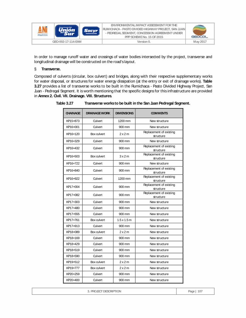
ENVIRONMENTAL IMPACT ASSESSMENT FOR THE RUMICHACA - PASTO DIVIDED HIGHWAY PROJECT, SAN JUAN
- PEDREGAL SEGMENT, CONCESSION AGREEMENT UNDER PPP SCHEME No. 15 OF 2015
GEO-002-17-114-EAM Version 0. May 2017
3. PROJECT DESCRIPTION
Page | 107
In order to manage runoff water and crossings of water bodies intersected by the project, transverse and longitudinal drainage will be constructed on the road's layout.
§ Transverse.
Composed of culverts (circular, box culvert) and bridges, along with their respective supplementary works for water disposal, or structures for water energy dissipation (at the entry or exit of drainage works). Table 3.27 provides a list of transverse works to be built in the Rumichaca - Pasto Divided Highway Project, San Juan - Pedregal Segment. It is worth mentioning that the specific designs for this infrastructure are provided in Annex 2. Civil. VII. Drainage. VIII. Structures.
Table 3.27 Transverse works to be built in the San Juan Pedregal Segment.
CHAINAGE DRAINAGE WORK DIMENSIONS COMMENTS
KP15+873 Culvert 1200 mm New structure
KP16+001 Culvert 900 mm New structure
KP16+120 Box culvert 2 x 2 m Replacement of existing structure
KP16+329 Culvert 900 mm New structure
KP16+432 Culvert 900 mm Replacement of existing structure
KP16+503 Box culvert 3 x 2 m Replacement of existing structure
KP16+722 Culvert 900 mm New structure
KP16+840 Culvert 900 mm Replacement of existing structure
KP16+922 Culvert 1200 mm Replacement of existing structure
KP17+004 Culvert 900 mm Replacement of existing structure
KP17+082 Culvert 900 mm Replacement of existing structure
KP17+303 Culvert 900 mm New structure
KP17+480 Culvert 900 mm New structure
KP17+555 Culvert 900 mm New structure
KP17+761 Box culvert 1.5 x 1.5 m New structure
KP17+913 Culvert 900 mm New structure
KP18+089 Box culvert 2 x 2 m New structure
KP18+169 Culvert 900 mm New structure
KP18+429 Culvert 900 mm New structure
KP18+519 Culvert 900 mm New structure
KP18+590 Culvert 900 mm New structure
KP19+512 Box culvert 2 x 2 m New structure
KP19+777 Box culvert 2 x 2 m New structure
KP20+259 Culvert 900 mm New structure
KP20+400 Culvert 900 mm New structure
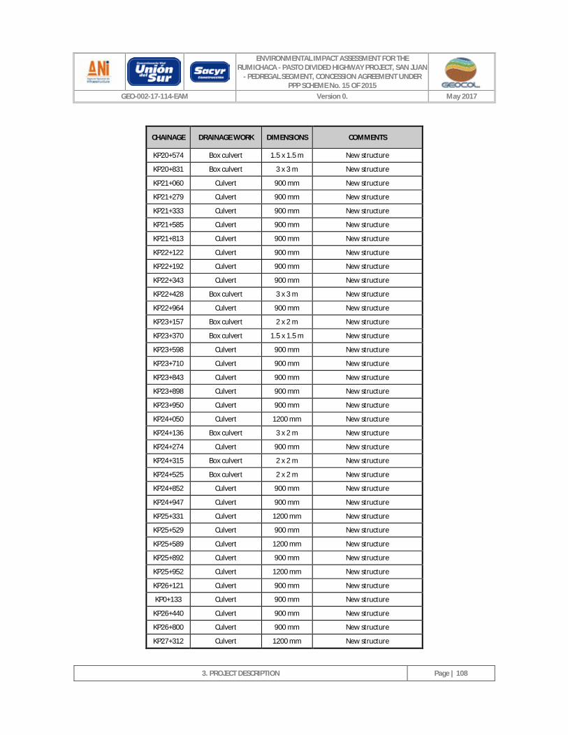
ENVIRONMENTAL IMPACT ASSESSMENT FOR THE RUMICHACA - PASTO DIVIDED HIGHWAY PROJECT, SAN JUAN
- PEDREGAL SEGMENT, CONCESSION AGREEMENT UNDER PPP SCHEME No. 15 OF 2015
GEO-002-17-114-EAM Version 0. May 2017
3. PROJECT DESCRIPTION
Page | 108
CHAINAGE DRAINAGE WORK DIMENSIONS COMMENTS
KP20+574 Box culvert 1.5 x 1.5 m New structure
KP20+831 Box culvert 3 x 3 m New structure
KP21+060 Culvert 900 mm New structure
KP21+279 Culvert 900 mm New structure
KP21+333 Culvert 900 mm New structure
KP21+585 Culvert 900 mm New structure
KP21+813 Culvert 900 mm New structure
KP22+122 Culvert 900 mm New structure
KP22+192 Culvert 900 mm New structure
KP22+343 Culvert 900 mm New structure
KP22+428 Box culvert 3 x 3 m New structure
KP22+964 Culvert 900 mm New structure
KP23+157 Box culvert 2 x 2 m New structure
KP23+370 Box culvert 1.5 x 1.5 m New structure
KP23+598 Culvert 900 mm New structure
KP23+710 Culvert 900 mm New structure
KP23+843 Culvert 900 mm New structure
KP23+898 Culvert 900 mm New structure
KP23+950 Culvert 900 mm New structure
KP24+050 Culvert 1200 mm New structure
KP24+136 Box culvert 3 x 2 m New structure
KP24+274 Culvert 900 mm New structure
KP24+315 Box culvert 2 x 2 m New structure
KP24+525 Box culvert 2 x 2 m New structure
KP24+852 Culvert 900 mm New structure
KP24+947 Culvert 900 mm New structure
KP25+331 Culvert 1200 mm New structure
KP25+529 Culvert 900 mm New structure
KP25+589 Culvert 1200 mm New structure
KP25+892 Culvert 900 mm New structure
KP25+952 Culvert 1200 mm New structure
KP26+121 Culvert 900 mm New structure
KP0+133 Culvert 900 mm New structure
KP26+440 Culvert 900 mm New structure
KP26+800 Culvert 900 mm New structure
KP27+312 Culvert 1200 mm New structure
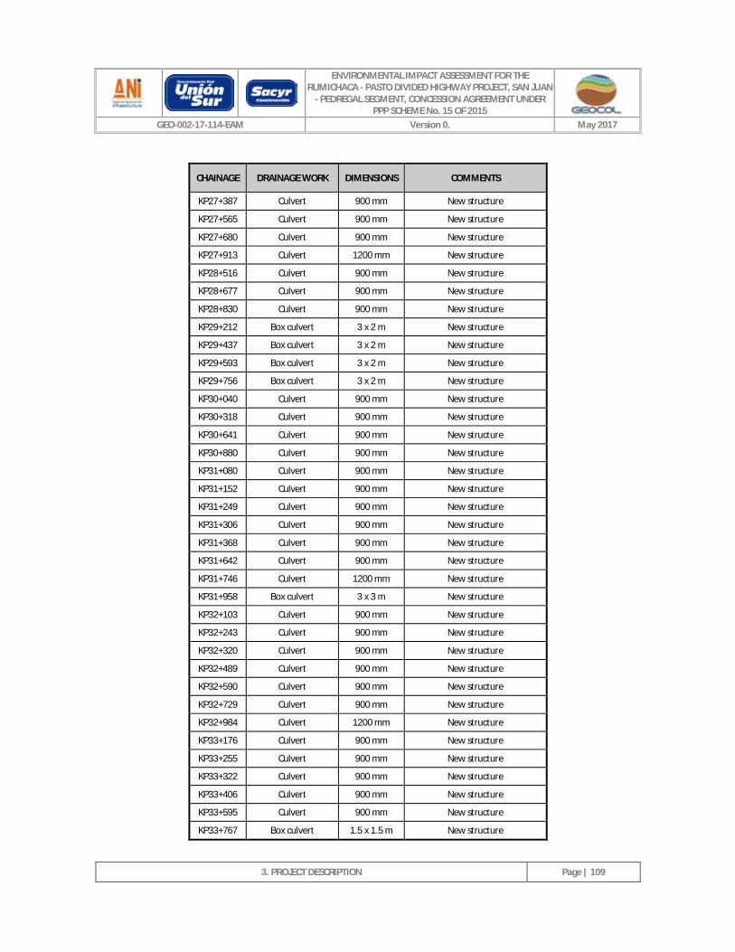
ENVIRONMENTAL IMPACT ASSESSMENT FOR THE RUMICHACA - PASTO DIVIDED HIGHWAY PROJECT, SAN JUAN
- PEDREGAL SEGMENT, CONCESSION AGREEMENT UNDER PPP SCHEME No. 15 OF 2015
GEO-002-17-114-EAM Version 0. May 2017
3. PROJECT DESCRIPTION
Page | 109
CHAINAGE DRAINAGE WORK DIMENSIONS COMMENTS
KP27+387 Culvert 900 mm New structure
KP27+565 Culvert 900 mm New structure
KP27+680 Culvert 900 mm New structure
KP27+913 Culvert 1200 mm New structure
KP28+516 Culvert 900 mm New structure
KP28+677 Culvert 900 mm New structure
KP28+830 Culvert 900 mm New structure
KP29+212 Box culvert 3 x 2 m New structure
KP29+437 Box culvert 3 x 2 m New structure
KP29+593 Box culvert 3 x 2 m New structure
KP29+756 Box culvert 3 x 2 m New structure
KP30+040 Culvert 900 mm New structure
KP30+318 Culvert 900 mm New structure
KP30+641 Culvert 900 mm New structure
KP30+880 Culvert 900 mm New structure
KP31+080 Culvert 900 mm New structure
KP31+152 Culvert 900 mm New structure
KP31+249 Culvert 900 mm New structure
KP31+306 Culvert 900 mm New structure
KP31+368 Culvert 900 mm New structure
KP31+642 Culvert 900 mm New structure
KP31+746 Culvert 1200 mm New structure
KP31+958 Box culvert 3 x 3 m New structure
KP32+103 Culvert 900 mm New structure
KP32+243 Culvert 900 mm New structure
KP32+320 Culvert 900 mm New structure
KP32+489 Culvert 900 mm New structure
KP32+590 Culvert 900 mm New structure
KP32+729 Culvert 900 mm New structure
KP32+984 Culvert 1200 mm New structure
KP33+176 Culvert 900 mm New structure
KP33+255 Culvert 900 mm New structure
KP33+322 Culvert 900 mm New structure
KP33+406 Culvert 900 mm New structure
KP33+595 Culvert 900 mm New structure
KP33+767 Box culvert 1.5 x 1.5 m New structure
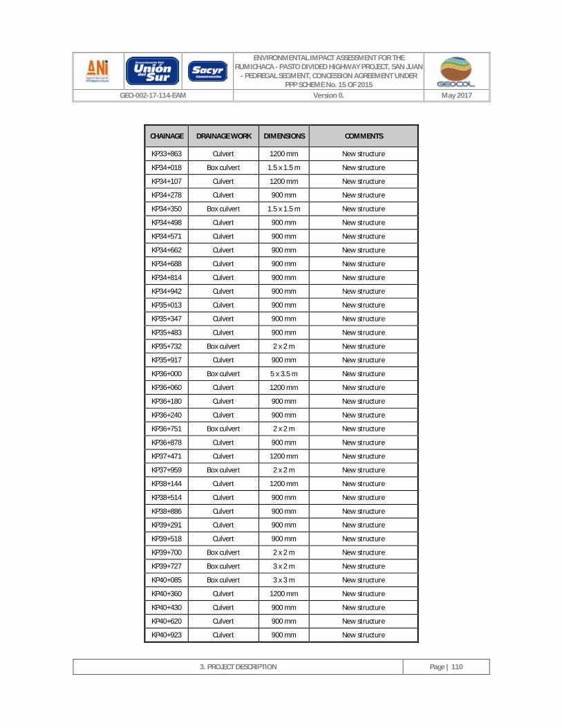
ENVIRONMENTAL IMPACT ASSESSMENT FOR THE RUMICHACA - PASTO DIVIDED HIGHWAY PROJECT, SAN JUAN
- PEDREGAL SEGMENT, CONCESSION AGREEMENT UNDER PPP SCHEME No. 15 OF 2015
GEO-002-17-114-EAM Version 0. May 2017
3. PROJECT DESCRIPTION
Page | 110
CHAINAGE DRAINAGE WORK DIMENSIONS COMMENTS
KP33+863 Culvert 1200 mm New structure
KP34+018 Box culvert 1.5 x 1.5 m New structure
KP34+107 Culvert 1200 mm New structure
KP34+278 Culvert 900 mm New structure
KP34+350 Box culvert 1.5 x 1.5 m New structure
KP34+498 Culvert 900 mm New structure
KP34+571 Culvert 900 mm New structure
KP34+662 Culvert 900 mm New structure
KP34+688 Culvert 900 mm New structure
KP34+814 Culvert 900 mm New structure
KP34+942 Culvert 900 mm New structure
KP35+013 Culvert 900 mm New structure
KP35+347 Culvert 900 mm New structure
KP35+483 Culvert 900 mm New structure
KP35+732 Box culvert 2 x 2 m New structure
KP35+917 Culvert 900 mm New structure
KP36+000 Box culvert 5 x 3.5 m New structure
KP36+060 Culvert 1200 mm New structure
KP36+180 Culvert 900 mm New structure
KP36+240 Culvert 900 mm New structure
KP36+751 Box culvert 2 x 2 m New structure
KP36+878 Culvert 900 mm New structure
KP37+471 Culvert 1200 mm New structure
KP37+959 Box culvert 2 x 2 m New structure
KP38+144 Culvert 1200 mm New structure
KP38+514 Culvert 900 mm New structure
KP38+886 Culvert 900 mm New structure
KP39+291 Culvert 900 mm New structure
KP39+518 Culvert 900 mm New structure
KP39+700 Box culvert 2 x 2 m New structure
KP39+727 Box culvert 3 x 2 m New structure
KP40+085 Box culvert 3 x 3 m New structure
KP40+360 Culvert 1200 mm New structure
KP40+430 Culvert 900 mm New structure
KP40+620 Culvert 900 mm New structure
KP40+923 Culvert 900 mm New structure
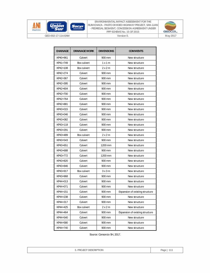
ENVIRONMENTAL IMPACT ASSESSMENT FOR THE RUMICHACA - PASTO DIVIDED HIGHWAY PROJECT, SAN JUAN
- PEDREGAL SEGMENT, CONCESSION AGREEMENT UNDER PPP SCHEME No. 15 OF 2015
GEO-002-17-114-EAM Version 0. May 2017
3. PROJECT DESCRIPTION
Page | 111
CHAINAGE DRAINAGE WORK DIMENSIONS COMMENTS
KP40+961 Culvert 900 mm New structure
KP41+749 Box culvert 1 x 1 m New structure
KP42+108 Box culvert 2 x 2 m New structure
KP42+274 Culvert 900 mm New structure
KP42+367 Culvert 900 mm New structure
KP42+395 Culvert 900 mm New structure
KP42+604 Culvert 900 mm New structure
KP42+700 Culvert 900 mm New structure
KP42+764 Culvert 900 mm New structure
KP42+881 Culvert 900 mm New structure
KP43+015 Culvert 900 mm New structure
KP43+046 Culvert 900 mm New structure
KP43+082 Culvert 900 mm New structure
KP43+118 Culvert 900 mm New structure
KP43+291 Culvert 900 mm New structure
KP43+489 Box culvert 2 x 2 m New structure
KP43+543 Culvert 900 mm New structure
KP43+651 Culvert 1200 mm New structure
KP43+688 Culvert 900 mm New structure
KP43+772 Culvert 1200 mm New structure
KP43+820 Culvert 900 mm New structure
KP43+846 Culvert 900 mm New structure
KP43+917 Box culvert 3 x 3 m New structure
KP43+968 Culvert 900 mm New structure
KP44+013 Culvert 900 mm New structure
KP44+071 Culvert 900 mm New structure
KP44+151 Culvert 900 mm Expansion of existing structure
KP44+238 Culvert 900 mm New structure
KP44+317 Culvert 900 mm New structure
KP44+425 Box culvert 2 x 2 m New structure
KP44+464 Culvert 900 mm Expansion of existing structure
KP44+540 Culvert 900 mm New structure
KP44+580 Culvert 900 mm New structure
KP44+740 Culvert 900 mm New structure
Source: Consorcio SH, 2017.
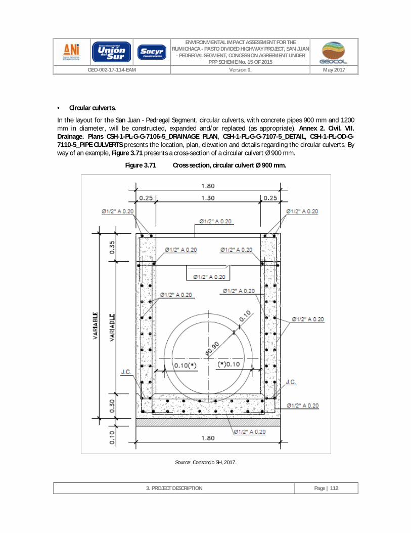
ENVIRONMENTAL IMPACT ASSESSMENT FOR THE RUMICHACA - PASTO DIVIDED HIGHWAY PROJECT, SAN JUAN
- PEDREGAL SEGMENT, CONCESSION AGREEMENT UNDER PPP SCHEME No. 15 OF 2015
GEO-002-17-114-EAM Version 0. May 2017
3. PROJECT DESCRIPTION
Page | 112
· Circular culverts.
In the layout for the San Juan - Pedregal Segment, circular culverts, with concrete pipes 900 mm and 1200 mm in diameter, will be constructed, expanded and/or replaced (as appropriate). Annex 2. Civil. VII. Drainage. Plans CSH-1-PL-G-G-7106-5_DRAINAGE PLAN, CSH-1-PL-G-G-7107-5_DETAIL, CSH-1-PL-OD-G-7110-5_PIPE CULVERTS presents the location, plan, elevation and details regarding the circular culverts. By way of an example, Figure 3.71 presents a cross-section of a circular culvert Ø 900 mm.
Figure 3.71 Cross section, circular culvert Ø 900 mm.
Source: Consorcio SH, 2017.
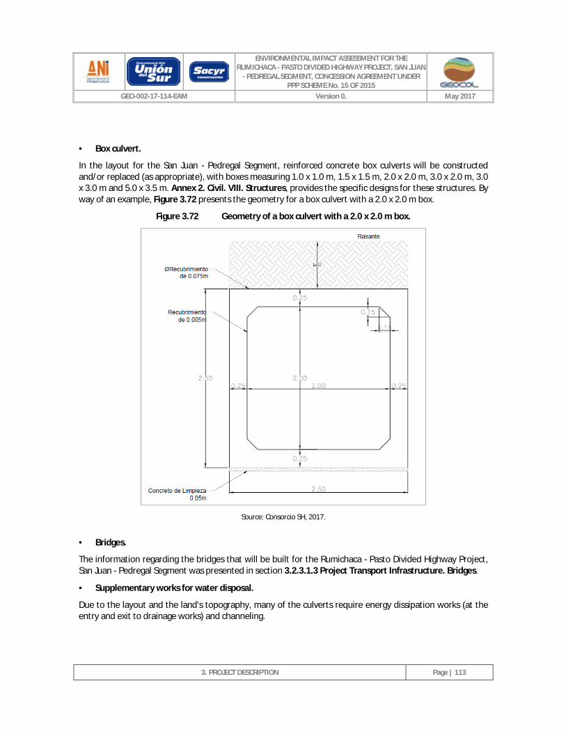
ENVIRONMENTAL IMPACT ASSESSMENT FOR THE RUMICHACA - PASTO DIVIDED HIGHWAY PROJECT, SAN JUAN
- PEDREGAL SEGMENT, CONCESSION AGREEMENT UNDER PPP SCHEME No. 15 OF 2015
GEO-002-17-114-EAM Version 0. May 2017
3. PROJECT DESCRIPTION
Page | 113
· Box culvert.
In the layout for the San Juan - Pedregal Segment, reinforced concrete box culverts will be constructed and/or replaced (as appropriate), with boxes measuring 1.0 x 1.0 m, 1.5 x 1.5 m, 2.0 x 2.0 m, 3.0 x 2.0 m, 3.0 x 3.0 m and 5.0 x 3.5 m. Annex 2. Civil. VIII. Structures, provides the specific designs for these structures. By way of an example, Figure 3.72 presents the geometry for a box culvert with a 2.0 x 2.0 m box.
Figure 3.72 Geometry of a box culvert with a 2.0 x 2.0 m box.
Source: Consorcio SH, 2017.
· Bridges.
The information regarding the bridges that will be built for the Rumichaca - Pasto Divided Highway Project, San Juan - Pedregal Segment was presented in section 3.2.3.1.3 Project Transport Infrastructure. Bridges.
· Supplementary works for water disposal.
Due to the layout and the land's topography, many of the culverts require energy dissipation works (at the entry and exit to drainage works) and channeling.
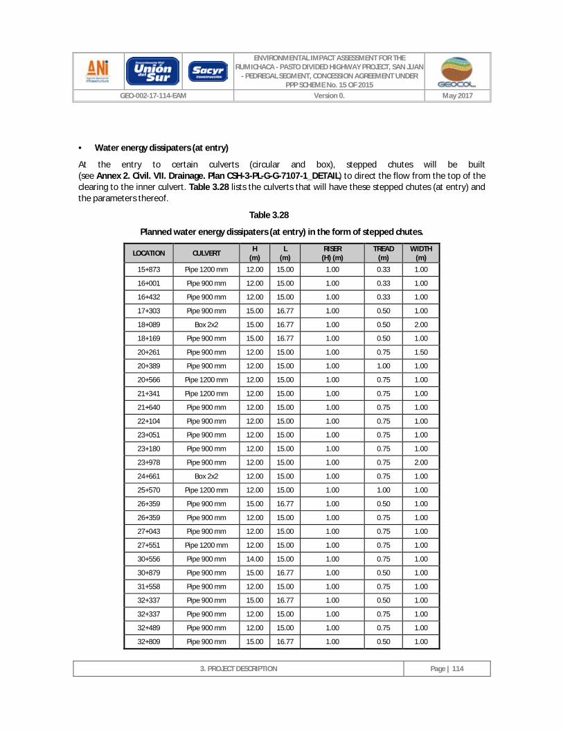
ENVIRONMENTAL IMPACT ASSESSMENT FOR THE RUMICHACA - PASTO DIVIDED HIGHWAY PROJECT, SAN JUAN
- PEDREGAL SEGMENT, CONCESSION AGREEMENT UNDER PPP SCHEME No. 15 OF 2015
GEO-002-17-114-EAM Version 0. May 2017
3. PROJECT DESCRIPTION
Page | 114
· Water energy dissipaters (at entry)
At the entry to certain culverts (circular and box), stepped chutes will be built (see Annex 2. Civil. VII. Drainage. Plan CSH-3-PL-G-G-7107-1_DETAIL) to direct the flow from the top of the clearing to the inner culvert. Table 3.28 lists the culverts that will have these stepped chutes (at entry) and the parameters thereof.
Table 3.28
Planned water energy dissipaters (at entry) in the form of stepped chutes.
LOCATION CULVERT H (m)
L (m)
RISER (H) (m)
TREAD (m)
WIDTH (m)
15+873 Pipe 1200 mm 12.00 15.00 1.00 0.33 1.00
16+001 Pipe 900 mm 12.00 15.00 1.00 0.33 1.00
16+432 Pipe 900 mm 12.00 15.00 1.00 0.33 1.00
17+303 Pipe 900 mm 15.00 16.77 1.00 0.50 1.00
18+089 Box 2x2 15.00 16.77 1.00 0.50 2.00
18+169 Pipe 900 mm 15.00 16.77 1.00 0.50 1.00
20+261 Pipe 900 mm 12.00 15.00 1.00 0.75 1.50
20+389 Pipe 900 mm 12.00 15.00 1.00 1.00 1.00
20+566 Pipe 1200 mm 12.00 15.00 1.00 0.75 1.00
21+341 Pipe 1200 mm 12.00 15.00 1.00 0.75 1.00
21+640 Pipe 900 mm 12.00 15.00 1.00 0.75 1.00
22+104 Pipe 900 mm 12.00 15.00 1.00 0.75 1.00
23+051 Pipe 900 mm 12.00 15.00 1.00 0.75 1.00
23+180 Pipe 900 mm 12.00 15.00 1.00 0.75 1.00
23+978 Pipe 900 mm 12.00 15.00 1.00 0.75 2.00
24+661 Box 2x2 12.00 15.00 1.00 0.75 1.00
25+570 Pipe 1200 mm 12.00 15.00 1.00 1.00 1.00
26+359 Pipe 900 mm 15.00 16.77 1.00 0.50 1.00
26+359 Pipe 900 mm 12.00 15.00 1.00 0.75 1.00
27+043 Pipe 900 mm 12.00 15.00 1.00 0.75 1.00
27+551 Pipe 1200 mm 12.00 15.00 1.00 0.75 1.00
30+556 Pipe 900 mm 14.00 15.00 1.00 0.75 1.00
30+879 Pipe 900 mm 15.00 16.77 1.00 0.50 1.00
31+558 Pipe 900 mm 12.00 15.00 1.00 0.75 1.00
32+337 Pipe 900 mm 15.00 16.77 1.00 0.50 1.00
32+337 Pipe 900 mm 12.00 15.00 1.00 0.75 1.00
32+489 Pipe 900 mm 12.00 15.00 1.00 0.75 1.00
32+809 Pipe 900 mm 15.00 16.77 1.00 0.50 1.00
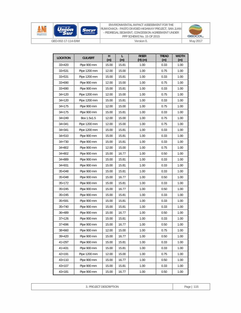
ENVIRONMENTAL IMPACT ASSESSMENT FOR THE RUMICHACA - PASTO DIVIDED HIGHWAY PROJECT, SAN JUAN
- PEDREGAL SEGMENT, CONCESSION AGREEMENT UNDER PPP SCHEME No. 15 OF 2015
GEO-002-17-114-EAM Version 0. May 2017
3. PROJECT DESCRIPTION
Page | 115
LOCATION CULVERT H (m)
L (m)
RISER (H) (m)
TREAD (m)
WIDTH (m)
33+420 Pipe 900 mm 15.00 15.81 1.00 0.33 1.00
33+531 Pipe 1200 mm 12.00 15.00 1.00 0.75 1.00
33+531 Pipe 1200 mm 15.00 15.81 1.00 0.33 1.00
33+690 Pipe 900 mm 12.00 15.00 1.00 0.75 1.00
33+690 Pipe 900 mm 15.00 15.81 1.00 0.33 1.00
34+120 Pipe 1200 mm 12.00 15.00 1.00 0.75 1.00
34+120 Pipe 1200 mm 15.00 15.81 1.00 0.33 1.00
34+175 Pipe 900 mm 12.00 15.00 1.00 0.75 1.00
34+175 Pipe 900 mm 15.00 15.81 1.00 0.33 1.00
34+249 Box 1.5x1.5 12.00 15.00 1.00 0.75 1.00
34+341 Pipe 1200 mm 12.00 15.00 1.00 0.75 1.00
34+341 Pipe 1200 mm 15.00 15.81 1.00 0.33 1.00
34+510 Pipe 900 mm 15.00 15.81 1.00 0.33 1.00
34+730 Pipe 900 mm 15.00 15.81 1.00 0.33 1.00
34+802 Pipe 900 mm 12.00 15.00 1.00 0.75 1.00
34+802 Pipe 900 mm 15.00 16.77 1.00 0.50 1.00
34+889 Pipe 900 mm 15.00 15.81 1.00 0.33 1.00
34+931 Pipe 900 mm 15.00 15.81 1.00 0.33 1.00
35+048 Pipe 900 mm 15.00 15.81 1.00 0.33 1.00
35+048 Pipe 900 mm 15.00 16.77 1.00 0.50 1.00
35+172 Pipe 900 mm 15.00 15.81 1.00 0.33 1.00
35+245 Pipe 900 mm 15.00 16.77 1.00 0.50 1.00
35+245 Pipe 900 mm 15.00 15.81 1.00 0.33 1.00
35+591 Pipe 900 mm 15.00 15.81 1.00 0.33 1.00
35+740 Pipe 900 mm 15.00 15.81 1.00 0.33 1.00
36+489 Pipe 900 mm 15.00 16.77 1.00 0.50 1.00
37+126 Pipe 900 mm 15.00 15.81 1.00 0.33 1.00
37+696 Pipe 900 mm 15.00 16.77 1.00 0.50 1.00
38+660 Pipe 900 mm 12.00 15.00 1.00 0.75 1.00
39+420 Pipe 900 mm 15.00 16.77 1.00 0.50 1.00
41+297 Pipe 900 mm 15.00 15.81 1.00 0.33 1.00
41+431 Pipe 900 mm 15.00 15.81 1.00 0.33 1.00
42+191 Pipe 1200 mm 12.00 15.00 1.00 0.75 1.00
43+110 Pipe 900 mm 15.00 16.77 1.00 0.50 1.00
43+107 Pipe 900 mm 15.00 15.81 1.00 0.33 1.00
43+181 Pipe 900 mm 15.00 16.77 1.00 0.50 1.00
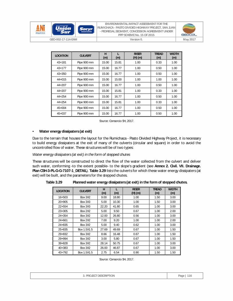
ENVIRONMENTAL IMPACT ASSESSMENT FOR THE RUMICHACA - PASTO DIVIDED HIGHWAY PROJECT, SAN JUAN
- PEDREGAL SEGMENT, CONCESSION AGREEMENT UNDER PPP SCHEME No. 15 OF 2015
GEO-002-17-114-EAM Version 0. May 2017
3. PROJECT DESCRIPTION
Page | 116
LOCATION CULVERT H (m)
L (m)
RISER (H) (m)
TREAD (m)
WIDTH (m)
43+181 Pipe 900 mm 15.00 15.81 1.00 0.33 1.00
43+177 Pipe 900 mm 15.00 16.77 1.00 0.50 1.00
43+350 Pipe 900 mm 15.00 16.77 1.00 0.50 1.00
44+015 Pipe 900 mm 15.00 15.00 1.00 1.00 1.00
44+207 Pipe 900 mm 15.00 16.77 1.00 0.50 1.00
44+207 Pipe 900 mm 15.00 15.81 1.00 0.33 1.00
44+254 Pipe 900 mm 15.00 16.77 1.00 0.50 1.00
44+254 Pipe 900 mm 15.00 15.81 1.00 0.33 1.00
45+004 Pipe 900 mm 15.00 16.77 1.00 0.50 1.00
45+037 Pipe 900 mm 15.00 16.77 1.00 0.50 1.00
Source: Consorcio SH, 2017.
· Water energy dissipaters (at exit)
Due to the terrain that houses the layout for the Rumichaca - Pasto Divided Highway Project, it is necessary to build energy dissipaters at the exit of many of the culverts (circular and square) in order to avoid the uncontrolled flow of water. These structures will be of two types:
Water energy dissipaters (at exit) in the form of stepped chutes
These structures will be constructed to direct the flow of the water collected from the culvert and deliver such water, conforming -to the extent possible- to the slope's gradient (see Annex 2. Civil. VII. Drainage. Plan CSH-3-PL-G-G-7107-1_DETAIL). Table 3.29 lists the culverts for which these water energy dissipaters (at exit) will be built, and the parameters for the stepped chutes.
Table 3.29 Planned water energy dissipaters (at exit) in the form of stepped chutes.
LOCATION CULVERT H (m)
L (m)
RISER (H) (m)
TREAD (m)
WIDTH (m)
16+503 Box 3X2 9.00 18.80 1.00 1.50 3.00 20+905 Box 3X3 5.00 10.30 1.00 1.50 3.00 22+554 Box 3X3 22.20 41.80 0.65 1.00 3.00 23+305 Box 2X2 5.00 9.50 0.67 1.00 2.00 24+354 Box 3X2 12.00 26.80 0.56 1.00 3.00 24+661 Box 2X2 7.00 9.20 1.00 1.00 2.00 24+835 Box 3X2 5.00 9.40 0.62 1.00 3.00 25+835 Box 1.5X1.5 27.69 49.69 0.67 1.00 1.50 29+832 Box 3X2 8.66 16.48 0.67 1.00 1.50 29+994 Box 3X2 3.00 5.80 0.67 1.00 1.50 39+828 Box 3X2 28.14 50.75 0.67 1.00 3.00 40+383 Box 3X2 26.00 46.87 0.67 1.00 3.00 43+792 Box 1.5X1.5 2.75 6.54 0.90 1.50 1.50
Source: Consorcio SH, 2017.
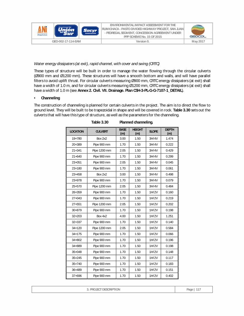
ENVIRONMENTAL IMPACT ASSESSMENT FOR THE RUMICHACA - PASTO DIVIDED HIGHWAY PROJECT, SAN JUAN
- PEDREGAL SEGMENT, CONCESSION AGREEMENT UNDER PPP SCHEME No. 15 OF 2015
GEO-002-17-114-EAM Version 0. May 2017
3. PROJECT DESCRIPTION
Page | 117
Water energy dissipaters (at exit), rapid channel, with cover and swing (CRTC)
These types of structure will be built in order to manage the water flowing through the circular culverts (Ø900 mm and Ø1200 mm). These structures will have a smooth bottom and walls, and will have parallel filters to avoid uplift thrust. For circular culverts measuring Ø900 mm, CRTC energy dissipaters (at exit) shall have a width of 1.0 m, and for circular culverts measuring Ø1200 mm, CRTC energy dissipaters (at exit) shall have a width of 1.0 m (see Annex 2. Civil. VII. Drainage. Plan CSH-3-PL-G-G-7107-1_DETAIL).
· Channeling
The construction of channeling is planned for certain culverts in the project. The aim is to direct the flow to ground level. They will be built to be trapezoidal in shape and will be covered in rock. Table 3.30 sets out the culverts that will have this type of structure, as well as the parameters for the channeling.
Table 3.30 Planned channeling.
LOCATION CULVERT BASE (m)
HEIGHT (m) SLOPE DEPTH
(m)
19+780 Box 2x2 3.00 1.50 3H/4V 1.474
20+389 Pipe 900 mm 1.70 1.50 3H/4V 0.222
21+341 Pipe 1200 mm 2.05 1.50 3H/4V 0.429
21+640 Pipe 900 mm 1.70 1.50 3H/4V 0.299
23+051 Pipe 900 mm 2.05 1.50 3H/4V 0.045
23+180 Pipe 900 mm 1.70 1.50 3H/4V 0.061
23+458 Box 2x2 3.00 1.50 3H/4V 0.498
23+978 Pipe 900 mm 1.70 1.50 3H/4V 0.079
25+570 Pipe 1200 mm 2.05 1.50 3H/4V 0.484
26+359 Pipe 900 mm 1.70 1.50 1H/2V 0.160
27+043 Pipe 900 mm 1.70 1.50 1H/2V 0.219
27+551 Pipe 1200 mm 2.05 1.50 1H/2V 0.202
30+879 Pipe 900 mm 1.70 1.50 1H/2V 0.198
32+203 Box 4x2 4.00 1.50 1H/2V 1.251
32+337 Pipe 900 mm 1.70 1.50 1H/2V 0.140
34+120 Pipe 1200 mm 2.05 1.50 1H/2V 0.584
34+175 Pipe 900 mm 1.70 1.50 1H/2V 0.066
34+802 Pipe 900 mm 1.70 1.50 1H/2V 0.196
34+889 Pipe 900 mm 1.70 1.50 1H/2V 0.198
35+048 Pipe 900 mm 1.70 1.50 1H/2V 0.148
35+245 Pipe 900 mm 1.70 1.50 1H/2V 0.117
35+740 Pipe 900 mm 1.70 1.50 1H/2V 0.183
36+489 Pipe 900 mm 1.70 1.50 1H/2V 0.151
37+696 Pipe 900 mm 1.70 1.50 1H/2V 0.402
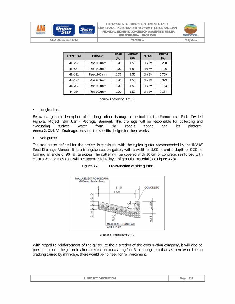
ENVIRONMENTAL IMPACT ASSESSMENT FOR THE RUMICHACA - PASTO DIVIDED HIGHWAY PROJECT, SAN JUAN
- PEDREGAL SEGMENT, CONCESSION AGREEMENT UNDER PPP SCHEME No. 15 OF 2015
GEO-002-17-114-EAM Version 0. May 2017
3. PROJECT DESCRIPTION
Page | 118
LOCATION CULVERT BASE (m)
HEIGHT (m) SLOPE DEPTH
(m)
41+297 Pipe 900 mm 1.70 1.50 1H/2V 0.260
41+431 Pipe 900 mm 1.70 1.50 1H/2V 0.196
42+191 Pipe 1200 mm 2.05 1.50 1H/2V 0.709
43+177 Pipe 900 mm 1.70 1.50 1H/2V 0.093
44+207 Pipe 900 mm 1.70 1.50 1H/2V 0.183
44+254 Pipe 900 mm 1.70 1.50 1H/2V 0.164
Source: Consorcio SH, 2017.
· Longitudinal.
Below is a general description of the longitudinal drainage to be built for the Rumichaca - Pasto Divided Highway Project, San Juan - Pedregal Segment. This drainage will be responsible for collecting and evacuating surface water from the road's slopes and its platform. Annex 2. Civil. VII. Drainage. presents the specific designs for these works.
· Side gutter
The side gutter defined for the project is consistent with the typical gutter recommended by the INVIAS Road Drainage Manual. It is a triangular-section gutter, with a width of 1.00 m and a depth of 0.20 m, forming an angle of 90° at its slopes. The gutter will be covered with 10 cm of concrete, reinforced with electro-welded mesh and will be supported on a layer of granular material (see Figure 3.73).
Figure 3.73 Cross-section of side gutter.
Source: Consorcio SH, 2017.
With regard to reinforcement of the gutter, at the discretion of the construction company, it will also be possible to build the gutter in alternate sections measuring 2 or 3 m in length, so that, as there would be no cracking caused by shrinkage, there would be no need for reinforcement.
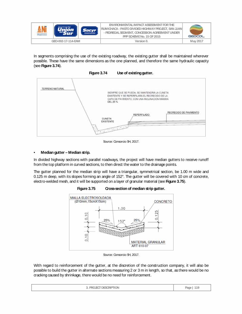
ENVIRONMENTAL IMPACT ASSESSMENT FOR THE RUMICHACA - PASTO DIVIDED HIGHWAY PROJECT, SAN JUAN
- PEDREGAL SEGMENT, CONCESSION AGREEMENT UNDER PPP SCHEME No. 15 OF 2015
GEO-002-17-114-EAM Version 0. May 2017
3. PROJECT DESCRIPTION
Page | 119
In segments comprising the use of the existing roadway, the existing gutter shall be maintained wherever possible. These have the same dimensions as the one planned, and therefore the same hydraulic capacity (see Figure 3.74).
Figure 3.74 Use of existing gutter.
Source: Consorcio SH, 2017.
· Median gutter – Median strip.
In divided highway sections with parallel roadways, the project will have median gutters to receive runoff from the top platform in curved sections, to then direct the water to the drainage points.
The gutter planned for the median strip will have a triangular, symmetrical section, be 1.00 m wide and 0.125 m deep, with its slopes forming an angle of 152°. The gutter will be covered with 10 cm of concrete, electro-welded mesh, and it will be supported on a layer of granular material (see Figure 3.75).
Figure 3.75 Cross-section of median strip gutter.
Source: Consorcio SH, 2017.
With regard to reinforcement of the gutter, at the discretion of the construction company, it will also be possible to build the gutter in alternate sections measuring 2 or 3 m in length, so that, as there would be no cracking caused by shrinkage, there would be no need for reinforcement.
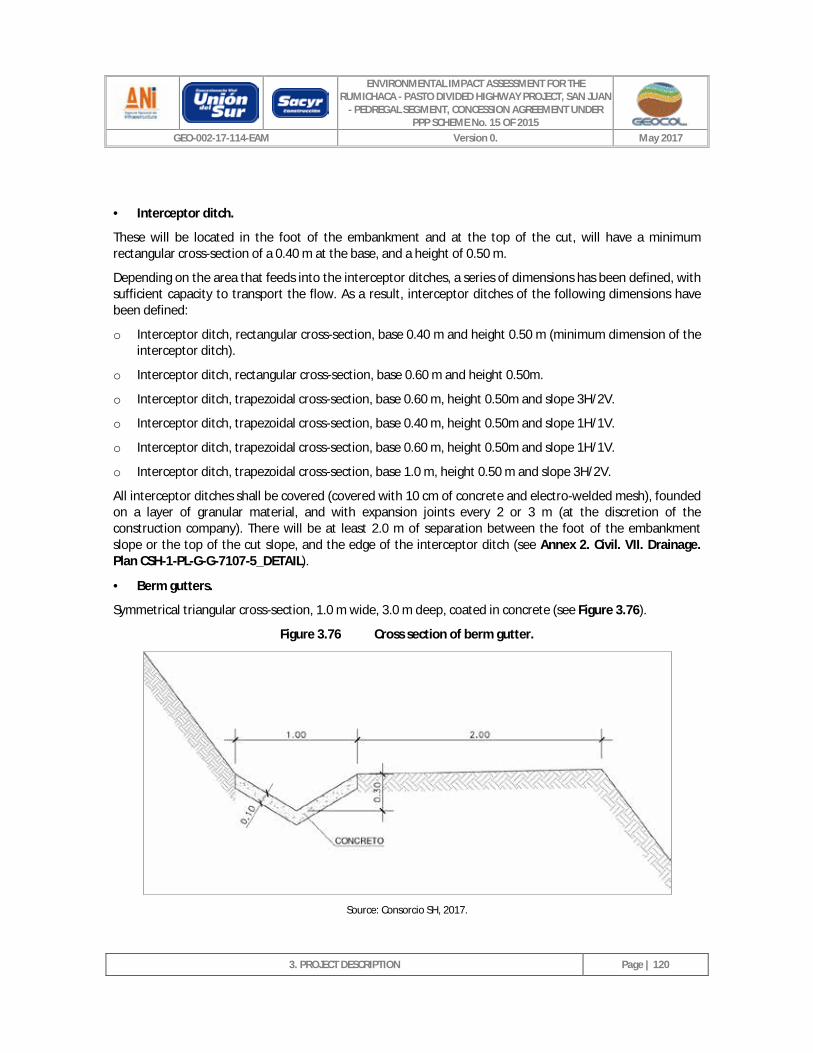
ENVIRONMENTAL IMPACT ASSESSMENT FOR THE RUMICHACA - PASTO DIVIDED HIGHWAY PROJECT, SAN JUAN
- PEDREGAL SEGMENT, CONCESSION AGREEMENT UNDER PPP SCHEME No. 15 OF 2015
GEO-002-17-114-EAM Version 0. May 2017
3. PROJECT DESCRIPTION
Page | 120
· Interceptor ditch.
These will be located in the foot of the embankment and at the top of the cut, will have a minimum rectangular cross-section of a 0.40 m at the base, and a height of 0.50 m.
Depending on the area that feeds into the interceptor ditches, a series of dimensions has been defined, with sufficient capacity to transport the flow. As a result, interceptor ditches of the following dimensions have been defined:
o Interceptor ditch, rectangular cross-section, base 0.40 m and height 0.50 m (minimum dimension of the interceptor ditch).
o Interceptor ditch, rectangular cross-section, base 0.60 m and height 0.50m.
o Interceptor ditch, trapezoidal cross-section, base 0.60 m, height 0.50m and slope 3H/2V.
o Interceptor ditch, trapezoidal cross-section, base 0.40 m, height 0.50m and slope 1H/1V.
o Interceptor ditch, trapezoidal cross-section, base 0.60 m, height 0.50m and slope 1H/1V.
o Interceptor ditch, trapezoidal cross-section, base 1.0 m, height 0.50 m and slope 3H/2V.
All interceptor ditches shall be covered (covered with 10 cm of concrete and electro-welded mesh), founded on a layer of granular material, and with expansion joints every 2 or 3 m (at the discretion of the construction company). There will be at least 2.0 m of separation between the foot of the embankment slope or the top of the cut slope, and the edge of the interceptor ditch (see Annex 2. Civil. VII. Drainage. Plan CSH-1-PL-G-G-7107-5_DETAIL).
· Berm gutters.
Symmetrical triangular cross-section, 1.0 m wide, 3.0 m deep, coated in concrete (see Figure 3.76).
Figure 3.76 Cross section of berm gutter.
Source: Consorcio SH, 2017.
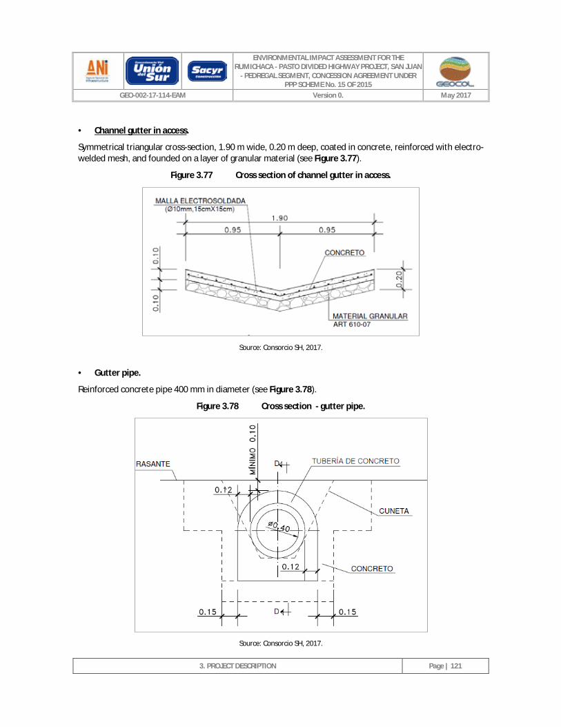
ENVIRONMENTAL IMPACT ASSESSMENT FOR THE RUMICHACA - PASTO DIVIDED HIGHWAY PROJECT, SAN JUAN
- PEDREGAL SEGMENT, CONCESSION AGREEMENT UNDER PPP SCHEME No. 15 OF 2015
GEO-002-17-114-EAM Version 0. May 2017
3. PROJECT DESCRIPTION
Page | 121
· Channel gutter in access.
Symmetrical triangular cross-section, 1.90 m wide, 0.20 m deep, coated in concrete, reinforced with electro-welded mesh, and founded on a layer of granular material (see Figure 3.77).
Figure 3.77 Cross section of channel gutter in access.
Source: Consorcio SH, 2017.
· Gutter pipe.
Reinforced concrete pipe 400 mm in diameter (see Figure 3.78).
Figure 3.78 Cross section - gutter pipe.
Source: Consorcio SH, 2017.
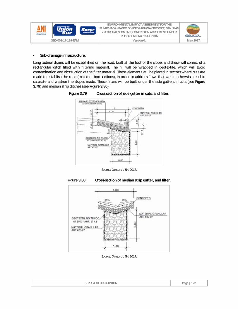
ENVIRONMENTAL IMPACT ASSESSMENT FOR THE RUMICHACA - PASTO DIVIDED HIGHWAY PROJECT, SAN JUAN
- PEDREGAL SEGMENT, CONCESSION AGREEMENT UNDER PPP SCHEME No. 15 OF 2015
GEO-002-17-114-EAM Version 0. May 2017
3. PROJECT DESCRIPTION
Page | 122
· Sub-drainage infrastructure.
Longitudinal drains will be established on the road, built at the foot of the slope, and these will consist of a rectangular ditch filled with filtering material. The fill will be wrapped in geotextile, which will avoid contamination and obstruction of the filter material. These elements will be placed in sectors where cuts are made to establish the road (mixed or box sections), in order to address flows that would otherwise tend to saturate and weaken the slopes made. These filters will be built under the side gutters in cuts (see Figure 3.79) and median strip ditches (see Figure 3.80).
Figure 3.79 Cross section of side gutter in cuts, and filter.
Source: Consorcio SH, 2017.
Figure 3.80 Cross-section of median strip gutter, and filter.
Source: Consorcio SH, 2017.
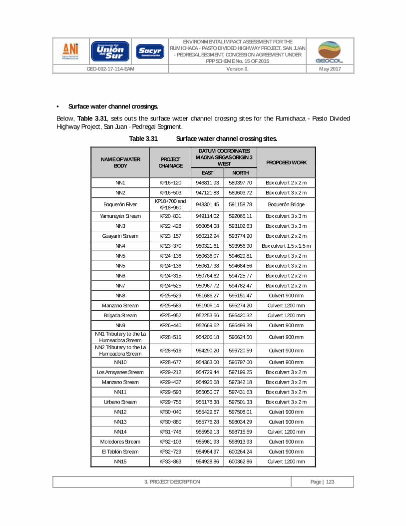
ENVIRONMENTAL IMPACT ASSESSMENT FOR THE RUMICHACA - PASTO DIVIDED HIGHWAY PROJECT, SAN JUAN
- PEDREGAL SEGMENT, CONCESSION AGREEMENT UNDER PPP SCHEME No. 15 OF 2015
GEO-002-17-114-EAM Version 0. May 2017
3. PROJECT DESCRIPTION
Page | 123
· Surface water channel crossings.
Below, Table 3.31, sets outs the surface water channel crossing sites for the Rumichaca - Pasto Divided Highway Project, San Juan - Pedregal Segment.
Table 3.31 Surface water channel crossing sites.
NAME OF WATER BODY
PROJECT CHAINAGE
DATUM COORDINATES MAGNA SIRGAS ORIGIN 3
WEST PROPOSED WORK
EAST NORTH
NN1 KP16+120 946811.93 589397.70 Box culvert 2 x 2 m
NN2 KP16+503 947121.83 589603.72 Box culvert 3 x 2 m
Boquerón River KP18+700 and KP18+960 948301.45 591158.78 Boquerón Bridge
Yamurayán Stream KP20+831 949114.02 592065.11 Box culvert 3 x 3 m
NN3 KP22+428 950054.08 593102.63 Box culvert 3 x 3 m
Guayarín Stream KP23+157 950212.94 593774.90 Box culvert 2 x 2 m
NN4 KP23+370 950321.61 593956.90 Box culvert 1.5 x 1.5 m
NN5 KP24+136 950636.07 594629.81 Box culvert 3 x 2 m
NN5 KP24+136 950617.38 594684.56 Box culvert 3 x 2 m
NN6 KP24+315 950764.62 594725.77 Box culvert 2 x 2 m
NN7 KP24+525 950967.72 594782.47 Box culvert 2 x 2 m
NN8 KP25+529 951686.27 595151.47 Culvert 900 mm
Manzano Stream KP25+589 951906.14 595274.20 Culvert 1200 mm
Brigada Stream KP25+952 952253.56 595420.32 Culvert 1200 mm
NN9 KP26+440 952669.62 595499.39 Culvert 900 mm
NN1 Tributary to the La Humeadora Stream KP28+516 954206.18 596624.50 Culvert 900 mm
NN2 Tributary to the La Humeadora Stream KP28+516 954290.20 596720.59 Culvert 900 mm
NN10 KP28+677 954363.00 596797.00 Culvert 900 mm
Los Arrayanes Stream KP29+212 954729.44 597199.25 Box culvert 3 x 2 m
Manzano Stream KP29+437 954925.68 597342.18 Box culvert 3 x 2 m
NN11 KP29+593 955050.07 597431.63 Box culvert 3 x 2 m
Urbano Stream KP29+756 955178.38 597501.33 Box culvert 3 x 2 m
NN12 KP30+040 955429.67 597508.01 Culvert 900 mm
NN13 KP30+880 955776.28 598034.29 Culvert 900 mm
NN14 KP31+746 955959.13 598715.59 Culvert 1200 mm
Moledores Stream KP32+103 955961.93 598913.93 Culvert 900 mm
El Tablón Stream KP32+729 954964.97 600264.24 Culvert 900 mm
NN15 KP33+863 954928.86 600362.86 Culvert 1200 mm
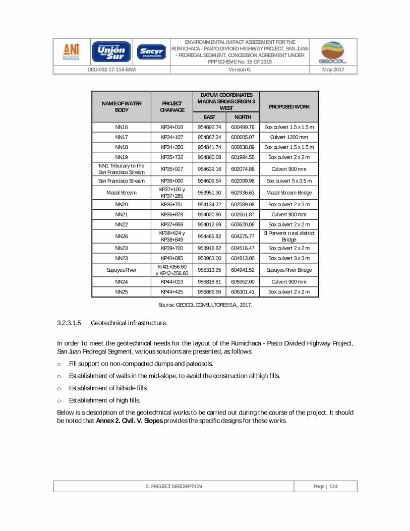
ENVIRONMENTAL IMPACT ASSESSMENT FOR THE RUMICHACA - PASTO DIVIDED HIGHWAY PROJECT, SAN JUAN
- PEDREGAL SEGMENT, CONCESSION AGREEMENT UNDER PPP SCHEME No. 15 OF 2015
GEO-002-17-114-EAM Version 0. May 2017
3. PROJECT DESCRIPTION
Page | 124
NAME OF WATER BODY
PROJECT CHAINAGE
DATUM COORDINATES MAGNA SIRGAS ORIGIN 3
WEST PROPOSED WORK
EAST NORTH
NN16 KP34+018 954892.74 600499.78 Box culvert 1.5 x 1.5 m
NN17 KP34+107 954867.24 600605.07 Culvert 1200 mm
NN18 KP34+350 954841.74 600838.89 Box culvert 1.5 x 1.5 m
NN19 KP35+732 954860.08 601994.55 Box culvert 2 x 2 m
NN1 Tributary to the San Francisco Stream KP35+917 954632.16 602074.88 Culvert 900 mm
San Francisco Stream KP36+000 954609.64 602099.98 Box culvert 5 x 3.5 m
Macal Stream KP37+100 y KP37+285 953951.30 602936.63 Macal Stream Bridge
NN20 KP36+751 954134.22 602589.08 Box culvert 2 x 2 m
NN21 KP36+878 954020.90 602661.87 Culvert 900 mm
NN22 KP37+959 954012.69 603620.06 Box culvert 2 x 2 m
NN26 KP38+624 y KP38+849 954465.82 604275.77 El Porvenir rural district
Bridge
NN23 KP39+700 953918.82 604516.47 Box culvert 2 x 2 m
NN23 KP40+085 953963.00 604813.00 Box culvert 3 x 3 m
Sapuyes River KP41+056.60 y KP42+256.60 955313.95 604941.52 Sapuyes River Bridge
NN24 KP44+013 956818.81 605952.00 Culvert 900 mm
NN25 KP44+425 956886.56 606301.41 Box culvert 2 x 2 m
Source: GEOCOL CONSULTORES S.A., 2017.
3.2.3.1.5 Geotechnical infrastructure.
In order to meet the geotechnical needs for the layout of the Rumichaca - Pasto Divided Highway Project, San Juan Pedregal Segment, various solutions are presented, as follows:
o Fill support on non-compacted dumps and paleosols.
o Establishment of walls in the mid-slope, to avoid the construction of high fills.
o Establishment of hillside fills.
o Establishment of high fills.
Below is a description of the geotechnical works to be carried out during the course of the project. It should be noted that Annex 2. Civil. V. Slopes provides the specific designs for these works.
ENVIRONMENTAL IMPACT ASSESSMENT FOR THE RUMICHACA - PASTO DIVIDED HIGHWAY PROJECT, SAN JUAN
- PEDREGAL SEGMENT, CONCESSION AGREEMENT UNDER PPP SCHEME No. 15 OF 2015
GEO-002-17-114-EAM Version 0. May 2017
3. PROJECT DESCRIPTION
Page | 125
· Typical geotechnical and/or stability works.
o Cut slopes.
The upper slope areas, where the material is more disturbed and is less apt, will be re-excavated in the first meters of the slope at a gradient of 2H/1V.
In order to avoid gullies from arising, in addition to the guard gutter at the top, practically the entire slope area will be covered with vegetation.
- Fill slopes.
- Berms.
The use of berms is reserved for slopes of heights greater than 20 m, foreseeing a berm every 15 meters in height, and we will study this arrangement in detail in case it entails substantial increases in the height of the cut. In cases where the materials are less suitable, the distance between berms will be reduced to 12 meters, allowing for berm-less slopes (less than 15 meters high).
The berms will have an inner, coated gutter. To prevent water from infiltrating the cut and runoff from spilling onto the lower slope, the berms should slope towards the inner gutter (3%). The berms should receive periodic maintenance to ensure their correct operation and avoid counter-productive effects regarding the durability and stability of the slope, and therefore the minimum width will be 3 meters (see Figure 3.81).
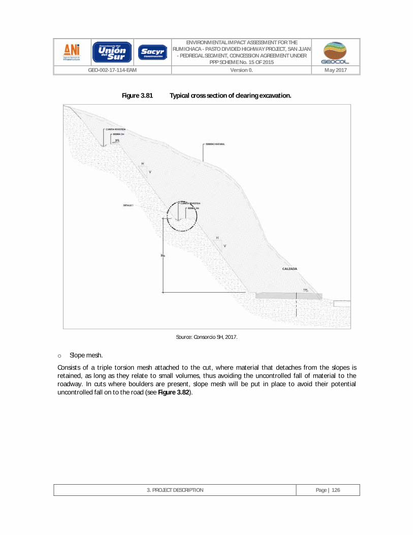
ENVIRONMENTAL IMPACT ASSESSMENT FOR THE RUMICHACA - PASTO DIVIDED HIGHWAY PROJECT, SAN JUAN
- PEDREGAL SEGMENT, CONCESSION AGREEMENT UNDER PPP SCHEME No. 15 OF 2015
GEO-002-17-114-EAM Version 0. May 2017
3. PROJECT DESCRIPTION
Page | 126
Figure 3.81 Typical cross section of clearing excavation.
Source: Consorcio SH, 2017.
o Slope mesh.
Consists of a triple torsion mesh attached to the cut, where material that detaches from the slopes is retained, as long as they relate to small volumes, thus avoiding the uncontrolled fall of material to the roadway. In cuts where boulders are present, slope mesh will be put in place to avoid their potential uncontrolled fall on to the road (see Figure 3.82).
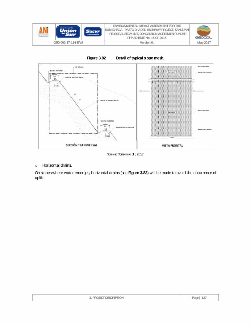
ENVIRONMENTAL IMPACT ASSESSMENT FOR THE RUMICHACA - PASTO DIVIDED HIGHWAY PROJECT, SAN JUAN
- PEDREGAL SEGMENT, CONCESSION AGREEMENT UNDER PPP SCHEME No. 15 OF 2015
GEO-002-17-114-EAM Version 0. May 2017
3. PROJECT DESCRIPTION
Page | 127
Figure 3.82 Detail of typical slope mesh.
Source: Consorcio SH, 2017.
o Horizontal drains.
On slopes where water emerges, horizontal drains (see Figure 3.83) will be made to avoid the occurrence of uplift.
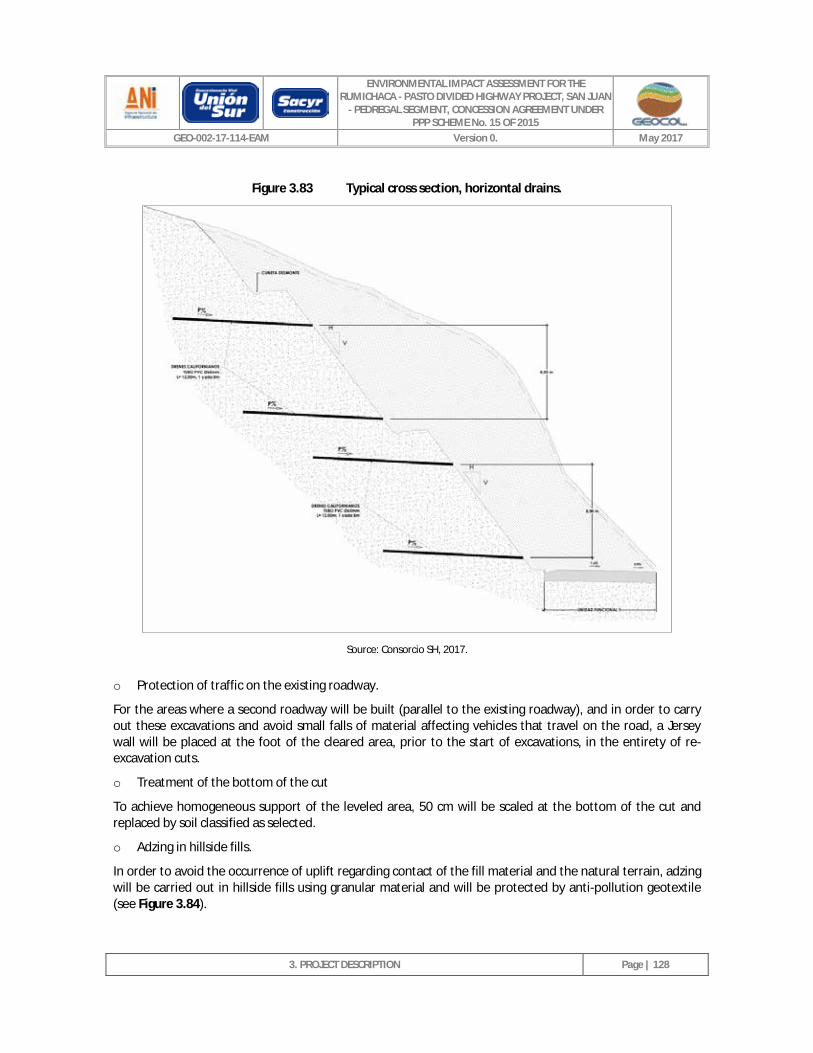
ENVIRONMENTAL IMPACT ASSESSMENT FOR THE RUMICHACA - PASTO DIVIDED HIGHWAY PROJECT, SAN JUAN
- PEDREGAL SEGMENT, CONCESSION AGREEMENT UNDER PPP SCHEME No. 15 OF 2015
GEO-002-17-114-EAM Version 0. May 2017
3. PROJECT DESCRIPTION
Page | 128
Figure 3.83 Typical cross section, horizontal drains.
Source: Consorcio SH, 2017.
o Protection of traffic on the existing roadway.
For the areas where a second roadway will be built (parallel to the existing roadway), and in order to carry out these excavations and avoid small falls of material affecting vehicles that travel on the road, a Jersey wall will be placed at the foot of the cleared area, prior to the start of excavations, in the entirety of re-excavation cuts.
o Treatment of the bottom of the cut
To achieve homogeneous support of the leveled area, 50 cm will be scaled at the bottom of the cut and replaced by soil classified as selected.
o Adzing in hillside fills.
In order to avoid the occurrence of uplift regarding contact of the fill material and the natural terrain, adzing will be carried out in hillside fills using granular material and will be protected by anti-pollution geotextile (see Figure 3.84).
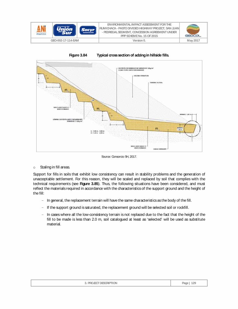
ENVIRONMENTAL IMPACT ASSESSMENT FOR THE RUMICHACA - PASTO DIVIDED HIGHWAY PROJECT, SAN JUAN
- PEDREGAL SEGMENT, CONCESSION AGREEMENT UNDER PPP SCHEME No. 15 OF 2015
GEO-002-17-114-EAM Version 0. May 2017
3. PROJECT DESCRIPTION
Page | 129
Figure 3.84 Typical cross section of adzing in hillside fills.
Source: Consorcio SH, 2017.
o Scaling in fill areas.
Support for fills in soils that exhibit low consistency can result in stability problems and the generation of unacceptable settlement. For this reason, they will be scaled and replaced by soil that complies with the technical requirements (see Figure 3.85). Thus, the following situations have been considered, and must reflect the materials required in accordance with the characteristics of the support ground and the height of the fill:
- In general, the replacement terrain will have the same characteristics as the body of the fill.
- If the support ground is saturated, the replacement ground will be selected soil or rockfill.
- In cases where all the low-consistency terrain is not replaced due to the fact that the height of the fill to be made is less than 2.0 m, soil catalogued at least as ‘selected’ will be used as substitute material.
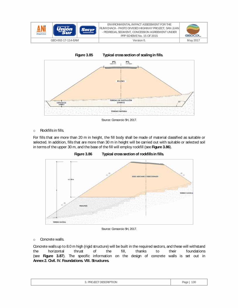
ENVIRONMENTAL IMPACT ASSESSMENT FOR THE RUMICHACA - PASTO DIVIDED HIGHWAY PROJECT, SAN JUAN
- PEDREGAL SEGMENT, CONCESSION AGREEMENT UNDER PPP SCHEME No. 15 OF 2015
GEO-002-17-114-EAM Version 0. May 2017
3. PROJECT DESCRIPTION
Page | 130
Figure 3.85 Typical cross section of scaling in fills.
Source: Consorcio SH, 2017.
o Rockfills in fills.
For fills that are more than 20 m in height, the fill body shall be made of material classified as suitable or selected. In addition, fills that are more than 30 m in height will be carried out with suitable or selected soil in terms of the upper 30 m, and the base of the fill will employ rockfill (see Figure 3.86).
Figure 3.86 Typical cross section of rockfills in fills.
Source: Consorcio SH, 2017.
o Concrete walls.
Concrete walls up to 8.0 m high (rigid structure) will be built in the required sectors, and these will withstand the horizontal thrust of the fill, thanks to their foundations (see Figure 3.87). The specific information on the design of concrete walls is set out in Annex 2. Civil. IV. Foundations. VIII. Structures.
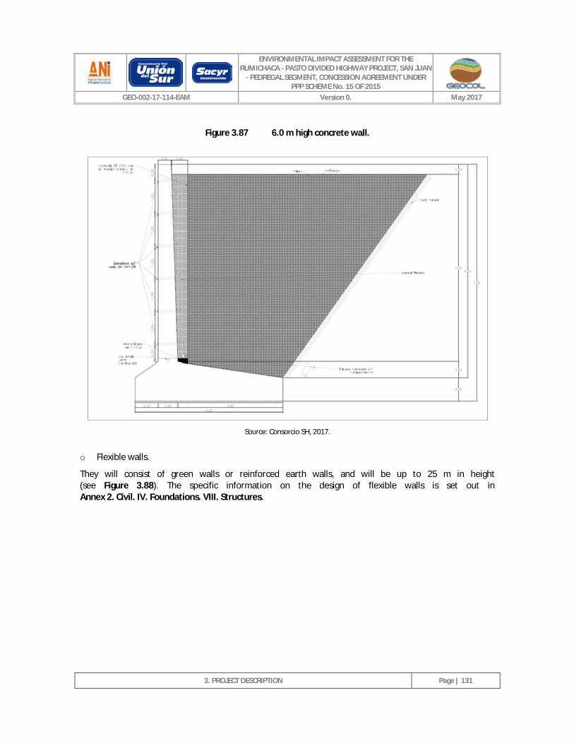
ENVIRONMENTAL IMPACT ASSESSMENT FOR THE RUMICHACA - PASTO DIVIDED HIGHWAY PROJECT, SAN JUAN
- PEDREGAL SEGMENT, CONCESSION AGREEMENT UNDER PPP SCHEME No. 15 OF 2015
GEO-002-17-114-EAM Version 0. May 2017
3. PROJECT DESCRIPTION
Page | 131
Figure 3.87 6.0 m high concrete wall.
Source: Consorcio SH, 2017.
o Flexible walls.
They will consist of green walls or reinforced earth walls, and will be up to 25 m in height (see Figure 3.88). The specific information on the design of flexible walls is set out in Annex 2. Civil. IV. Foundations. VIII. Structures.
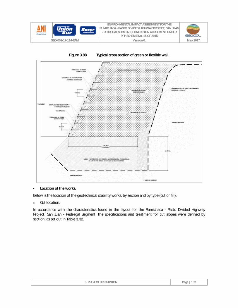
ENVIRONMENTAL IMPACT ASSESSMENT FOR THE RUMICHACA - PASTO DIVIDED HIGHWAY PROJECT, SAN JUAN
- PEDREGAL SEGMENT, CONCESSION AGREEMENT UNDER PPP SCHEME No. 15 OF 2015
GEO-002-17-114-EAM Version 0. May 2017
3. PROJECT DESCRIPTION
Page | 132
Figure 3.88 Typical cross section of green or flexible wall.
· Location of the works.
Below is the location of the geotechnical stability works, by section and by type (cut or fill).
o Cut location.
In accordance with the characteristics found in the layout for the Rumichaca - Pasto Divided Highway Project, San Juan - Pedregal Segment, the specifications and treatment for cut slopes were defined by section, as set out in Table 3.32.
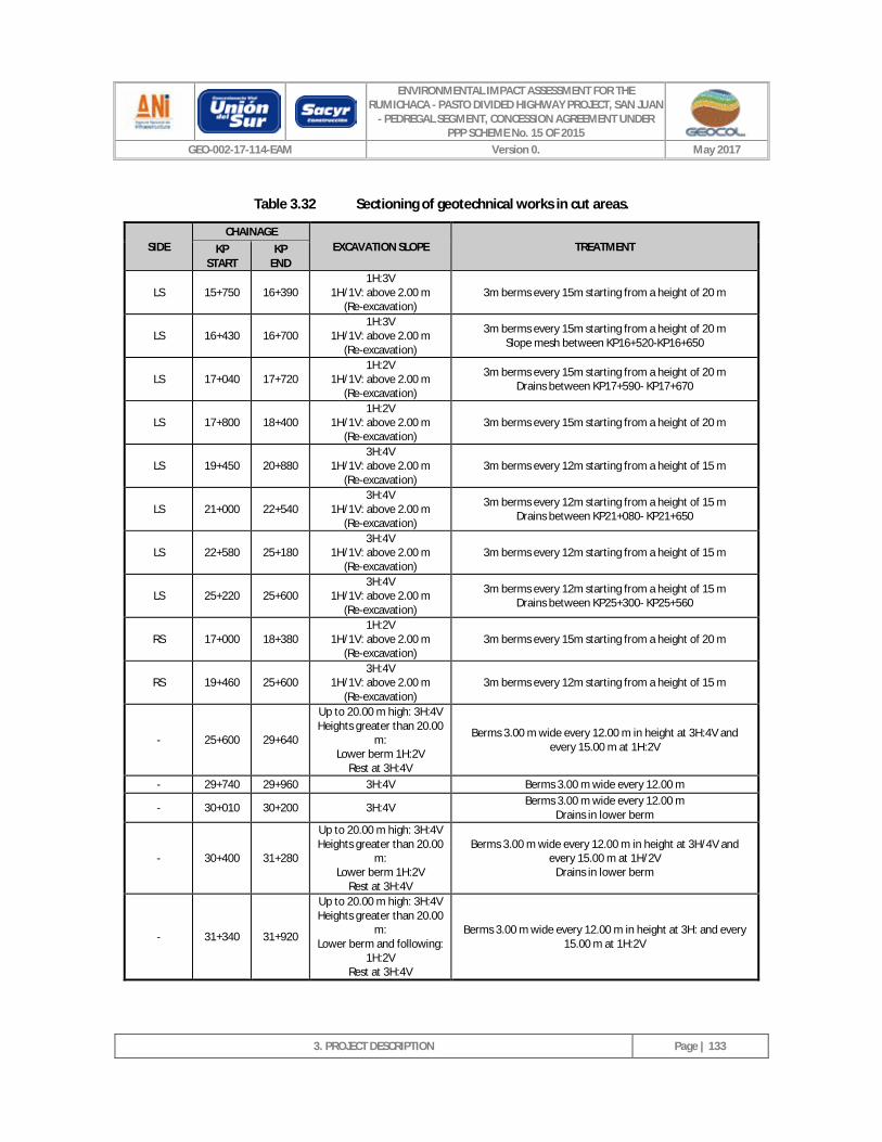
ENVIRONMENTAL IMPACT ASSESSMENT FOR THE RUMICHACA - PASTO DIVIDED HIGHWAY PROJECT, SAN JUAN
- PEDREGAL SEGMENT, CONCESSION AGREEMENT UNDER PPP SCHEME No. 15 OF 2015
GEO-002-17-114-EAM Version 0. May 2017
3. PROJECT DESCRIPTION
Page | 133
Table 3.32 Sectioning of geotechnical works in cut areas.
SIDE CHAINAGE
EXCAVATION SLOPE TREATMENT KP START
KP END
LS 15+750 16+390 1H:3V
1H/1V: above 2.00 m (Re-excavation)
3m berms every 15m starting from a height of 20 m
LS 16+430 16+700 1H:3V
1H/1V: above 2.00 m (Re-excavation)
3m berms every 15m starting from a height of 20 m Slope mesh between KP16+520-KP16+650
LS 17+040 17+720 1H:2V
1H/1V: above 2.00 m (Re-excavation)
3m berms every 15m starting from a height of 20 m Drains between KP17+590- KP17+670
LS 17+800 18+400 1H:2V
1H/1V: above 2.00 m (Re-excavation)
3m berms every 15m starting from a height of 20 m
LS 19+450 20+880 3H:4V
1H/1V: above 2.00 m (Re-excavation)
3m berms every 12m starting from a height of 15 m
LS 21+000 22+540 3H:4V
1H/1V: above 2.00 m (Re-excavation)
3m berms every 12m starting from a height of 15 m Drains between KP21+080- KP21+650
LS 22+580 25+180 3H:4V
1H/1V: above 2.00 m (Re-excavation)
3m berms every 12m starting from a height of 15 m
LS 25+220 25+600 3H:4V
1H/1V: above 2.00 m (Re-excavation)
3m berms every 12m starting from a height of 15 m Drains between KP25+300- KP25+560
RS 17+000 18+380 1H:2V
1H/1V: above 2.00 m (Re-excavation)
3m berms every 15m starting from a height of 20 m
RS 19+460 25+600 3H:4V
1H/1V: above 2.00 m (Re-excavation)
3m berms every 12m starting from a height of 15 m
- 25+600 29+640
Up to 20.00 m high: 3H:4V Heights greater than 20.00
m: Lower berm 1H:2V
Rest at 3H:4V
Berms 3.00 m wide every 12.00 m in height at 3H:4V and every 15.00 m at 1H:2V
- 29+740 29+960 3H:4V Berms 3.00 m wide every 12.00 m
- 30+010 30+200 3H:4V Berms 3.00 m wide every 12.00 m Drains in lower berm
- 30+400 31+280
Up to 20.00 m high: 3H:4V Heights greater than 20.00
m: Lower berm 1H:2V
Rest at 3H:4V
Berms 3.00 m wide every 12.00 m in height at 3H/4V and every 15.00 m at 1H/2V
Drains in lower berm
- 31+340 31+920
Up to 20.00 m high: 3H:4V Heights greater than 20.00
m: Lower berm and following:
1H:2V Rest at 3H:4V
Berms 3.00 m wide every 12.00 m in height at 3H: and every 15.00 m at 1H:2V
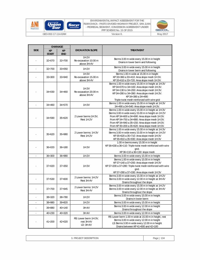
ENVIRONMENTAL IMPACT ASSESSMENT FOR THE RUMICHACA - PASTO DIVIDED HIGHWAY PROJECT, SAN JUAN
- PEDREGAL SEGMENT, CONCESSION AGREEMENT UNDER PPP SCHEME No. 15 OF 2015
GEO-002-17-114-EAM Version 0. May 2017
3. PROJECT DESCRIPTION
Page | 134
SIDE CHAINAGE
EXCAVATION SLOPE TREATMENT KP START
KP END
- 32+070 32+700 1H:2V
Re-excavation 10.00 m above 3H:4V
Berms 3.00 m wide every 15.00 m in height Drains in lower berm and following
- 32+700 33+050 1H:2V Berms 3.00 m wide every 15.00 m in height Drains in lower berm and following
- 33+300 33+940 1H:3V
Re-excavation 15.00 m above 3H:4V
Berms 1.00 m wide at 15.00 m in height KP 33+360 a 33+410: Area slope mesh 1H:3V. KP 33+610 a 33+720: Area slope mesh 1H:3V.
- 34+030 34+460 1H:3V
Re-excavation 20.00 m above 3H:4V
Berms 1.00 m wide every 15.00 m in height at 1H:3V KP 34+070 to 34+100: Area slope mesh 1H:3V. KP 34+130 to 34+200: Area slope mesh 1H:3V. KP 34+280 to 34+390: Area slope mesh 1H:3V.
KP 34+390 a 34+490: Triple-twist mesh reinforced with wire grid
- 34+460 34+570 1H:3V Berms 1.00 m wide every 15.00 m in height at 1H:3V 34+490 a 34+540: Area slope mesh 1H:3V.
- 34+590 35+620 2 Lower berms 1H:3V, Rest 1H:2V
Berms 1.00 m wide every 15.00 m in height at 1H:3V Berms 3.00 m wide every 15.00 m in height en 1H:2V From KP 34+600 a 34+690: Area slope mesh 1H:3V. From KP 34+750 a 34+880: Area slope mesh 1H:3V. From KP 34+940 a 35+150: Area slope mesh 1H:3V. From KP 35+200 a 35+620: Area slope mesh 1H:3V.
- 35+620 35+980 2 Lower berms: 1H:3V Rest 1H:2V
Berms 1.00 m wide every 15.00 m in height at 1H:3V Berms 3.00 m wide every 15.00 m in height en 1H:2V
KP 35+620 a 35+710: Area slope mesh 1H:3V KP 35+810 a 35+930: Area slope mesh 1H:3V
- 36+020 36+180 1H:3V
1.00 m berms every 15.00 m in height KP 36+030 a 36+110: Triple-twist mesh reinforced with wire
grid. KP 36+110 a 36+130: slope mesh
- 36+300 36+980 1H:2V Berms 3.00 m wide every 15.00 m in height
- 37+020 37+350 1H:3V
Berms 1.00 m wide every 15.00 m in height KP 37+140 a 37+200: Area slope mesh 1H:3V
KP 37+200 a 37+280: Triple-twist mesh reinforced with wire grid.
KP 37+280 a 37+330: Area slope mesh 1H:3V
- 37+530 37+600 2 Lower berms: 1H:2V Rest 3H:4V
Berms 3.00 m wide every 15.00 m in height at 1H:2V Berms 3.00 m wide every 12.00 m in height at 3H:4V
Drains throughout the slope
- 37+700 37+945 2 Lower berms: 1H:2V Rest 3H:4V
Berms 3.00 m wide every 15.00 m in height at 1H:2V Berms 3.00 m wide every 12.00 m in height at 3H:4V
Drains throughout the slope
- 38+320 38+780 1H:2V Berms 3.00 m wide every 15.00 m in height Drains in lower berm
- 38+980 39+820 1H:2V Berms 3.00 m wide every 15.00 m in height
- 39+880 40+140 3H:4V Berms 3.00 m wide every 12.00 m in height Drains throughout the slope
- 40+230 40+320 3H:4V Berms 3.00 m wide every 12.00 m in height
- 41+200 42+020 RS: Lower berm 1H:3V,
rest 3H:4V LD: 3H:4V
RS: Lower berm 1.00 m wide at 15.00 m in height, rest Berms 3.00 m wide every 12.00 m in height
LS: Berms 3.00 m wide every 12.00 m in height Drains between KP 41+600 and 42+100
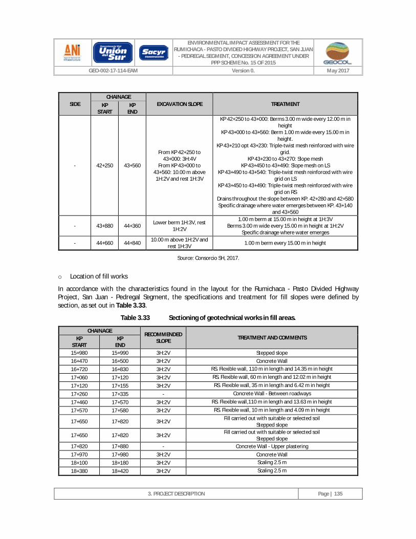
ENVIRONMENTAL IMPACT ASSESSMENT FOR THE RUMICHACA - PASTO DIVIDED HIGHWAY PROJECT, SAN JUAN
- PEDREGAL SEGMENT, CONCESSION AGREEMENT UNDER PPP SCHEME No. 15 OF 2015
GEO-002-17-114-EAM Version 0. May 2017
3. PROJECT DESCRIPTION
Page | 135
SIDE CHAINAGE
EXCAVATION SLOPE TREATMENT KP START
KP END
- 42+250 43+560
From KP 42+250 to 43+000: 3H:4V
From KP 43+000 to 43+560: 10.00 m above 1H:2V and rest 1H:3V
KP 42+250 to 43+000: Berms 3.00 m wide every 12.00 m in height
KP 43+000 to 43+560: Berm 1.00 m wide every 15.00 m in height.
KP 43+210 opt 43+230: Triple-twist mesh reinforced with wire grid.
KP 43+230 to 43+270: Slope mesh KP 43+450 to 43+490: Slope mesh on LS
KP 43+490 to 43+540: Triple-twist mesh reinforced with wire grid on LS
KP 43+450 to 43+490: Triple-twist mesh reinforced with wire grid on RS
Drains throughout the slope between KP. 42+280 and 42+580 Specific drainage where water emerges between KP. 43+140
and 43+560
- 43+880 44+360 Lower berm 1H:3V, rest 1H:2V
1.00 m berm at 15.00 m in height at 1H:3V Berms 3.00 m wide every 15.00 m in height at 1H:2V
Specific drainage where water emerges
- 44+660 44+840 10.00 m above 1H:2V and rest 1H:3V 1.00 m berm every 15.00 m in height
Source: Consorcio SH, 2017.
o Location of fill works
In accordance with the characteristics found in the layout for the Rumichaca - Pasto Divided Highway Project, San Juan - Pedregal Segment, the specifications and treatment for fill slopes were defined by section, as set out in Table 3.33.
Table 3.33 Sectioning of geotechnical works in fill areas.
CHAINAGE RECOMMENDED
SLOPE TREATMENT AND COMMENTS KP START
KP END
15+980 15+990 3H:2V Stepped slope 16+470 16+500 3H:2V Concrete Wall 16+720 16+830 3H:2V RS. Flexible wall, 110 m in length and 14.35 m in height
17+060 17+120 3H:2V RS. Flexible wall, 60 m in length and 12.02 m in height
17+120 17+155 3H:2V RS. Flexible wall, 35 m in length and 6.42 m in height
17+260 17+335 - Concrete Wall - Between roadways
17+460 17+570 3H:2V RS. Flexible wall,110 m in length and 13.63 m in height
17+570 17+580 3H:2V RS. Flexible wall, 10 m in length and 4.09 m in height
17+650 17+820 3H:2V Fill carried out with suitable or selected soil Stepped slope
17+650 17+820 3H:2V Fill carried out with suitable or selected soil Stepped slope
17+820 17+880 - Concrete Wall - Upper plastering 17+970 17+980 3H:2V Concrete Wall 18+100 18+180 3H:2V Scaling 2.5 m
18+380 18+420 3H:2V Scaling 2.5 m
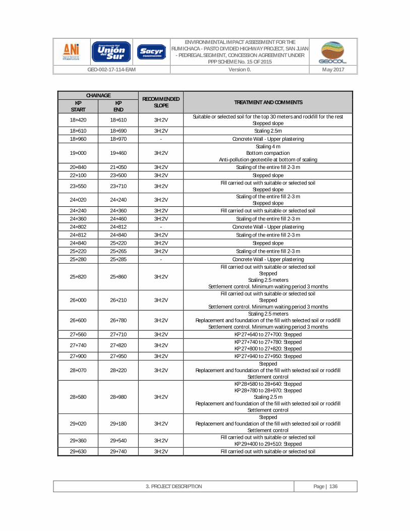
ENVIRONMENTAL IMPACT ASSESSMENT FOR THE RUMICHACA - PASTO DIVIDED HIGHWAY PROJECT, SAN JUAN
- PEDREGAL SEGMENT, CONCESSION AGREEMENT UNDER PPP SCHEME No. 15 OF 2015
GEO-002-17-114-EAM Version 0. May 2017
3. PROJECT DESCRIPTION
Page | 136
CHAINAGE RECOMMENDED
SLOPE TREATMENT AND COMMENTS KP START
KP END
18+420 18+610 3H:2V Suitable or selected soil for the top 30 meters and rockfill for the rest Stepped slope
18+610 18+690 3H:2V Scaling 2.5m 18+960 18+970 - Concrete Wall - Upper plastering
19+000 19+460 3H:2V Scaling 4 m
Bottom compaction Anti-pollution geotextile at bottom of scaling
20+840 21+050 3H:2V Scaling of the entire fill 2-3 m 22+100 23+500 3H:2V Stepped slope
23+550 23+710 3H:2V Fill carried out with suitable or selected soil Stepped slope
24+020 24+240 3H:2V Scaling of the entire fill 2-3 m Stepped slope
24+240 24+360 3H:2V Fill carried out with suitable or selected soil 24+360 24+460 3H:2V Scaling of the entire fill 2-3 m 24+802 24+812 - Concrete Wall - Upper plastering 24+812 24+840 3H:2V Scaling of the entire fill 2-3 m 24+840 25+220 3H:2V Stepped slope 25+220 25+265 3H:2V Scaling of the entire fill 2-3 m 25+280 25+285 - Concrete Wall - Upper plastering
25+820 25+860 3H:2V
Fill carried out with suitable or selected soil Stepped
Scaling 2.5 meters Settlement control. Minimum waiting period 3 months
26+000 26+210 3H:2V Fill carried out with suitable or selected soil
Stepped Settlement control. Minimum waiting period 3 months
26+600 26+780 3H:2V Scaling 2.5 meters
Replacement and foundation of the fill with selected soil or rockfill Settlement control. Minimum waiting period 3 months
27+560 27+710 3H:2V KP 27+640 to 27+700: Stepped
27+740 27+820 3H:2V KP 27+740 to 27+780: Stepped KP 27+800 to 27+820: Stepped
27+900 27+950 3H:2V KP 27+940 to 27+950: Stepped
28+070 28+220 3H:2V Stepped
Replacement and foundation of the fill with selected soil or rockfill Settlement control
28+580 28+980 3H:2V
KP 28+580 to 28+640: Stepped KP 28+780 to 28+970: Stepped
Scaling 2.5 m Replacement and foundation of the fill with selected soil or rockfill
Settlement control
29+020 29+180 3H:2V Stepped
Replacement and foundation of the fill with selected soil or rockfill Settlement control
29+360 29+540 3H:2V Fill carried out with suitable or selected soil KP 29+400 to 29+510: Stepped
29+630 29+740 3H:2V Fill carried out with suitable or selected soil
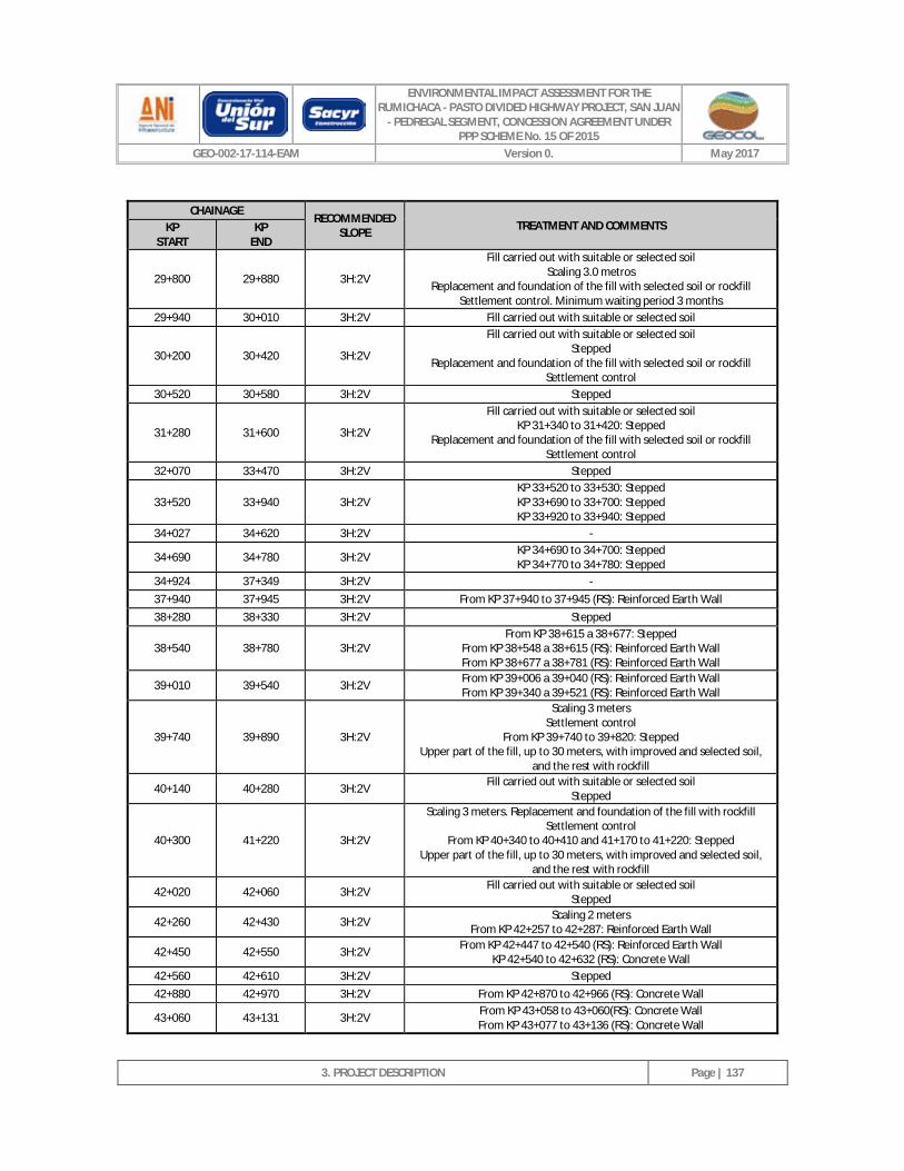
ENVIRONMENTAL IMPACT ASSESSMENT FOR THE RUMICHACA - PASTO DIVIDED HIGHWAY PROJECT, SAN JUAN
- PEDREGAL SEGMENT, CONCESSION AGREEMENT UNDER PPP SCHEME No. 15 OF 2015
GEO-002-17-114-EAM Version 0. May 2017
3. PROJECT DESCRIPTION
Page | 137
CHAINAGE RECOMMENDED
SLOPE TREATMENT AND COMMENTS KP START
KP END
29+800 29+880 3H:2V
Fill carried out with suitable or selected soil Scaling 3.0 metros
Replacement and foundation of the fill with selected soil or rockfill Settlement control. Minimum waiting period 3 months
29+940 30+010 3H:2V Fill carried out with suitable or selected soil
30+200 30+420 3H:2V
Fill carried out with suitable or selected soil Stepped
Replacement and foundation of the fill with selected soil or rockfill Settlement control
30+520 30+580 3H:2V Stepped
31+280 31+600 3H:2V
Fill carried out with suitable or selected soil KP 31+340 to 31+420: Stepped
Replacement and foundation of the fill with selected soil or rockfill Settlement control
32+070 33+470 3H:2V Stepped
33+520 33+940 3H:2V KP 33+520 to 33+530: Stepped KP 33+690 to 33+700: Stepped KP 33+920 to 33+940: Stepped
34+027 34+620 3H:2V -
34+690 34+780 3H:2V KP 34+690 to 34+700: Stepped KP 34+770 to 34+780: Stepped
34+924 37+349 3H:2V - 37+940 37+945 3H:2V From KP 37+940 to 37+945 (RS): Reinforced Earth Wall 38+280 38+330 3H:2V Stepped
38+540 38+780 3H:2V From KP 38+615 a 38+677: Stepped
From KP 38+548 a 38+615 (RS): Reinforced Earth Wall From KP 38+677 a 38+781 (RS): Reinforced Earth Wall
39+010 39+540 3H:2V From KP 39+006 a 39+040 (RS): Reinforced Earth Wall From KP 39+340 a 39+521 (RS): Reinforced Earth Wall
39+740 39+890 3H:2V
Scaling 3 meters Settlement control
From KP 39+740 to 39+820: Stepped Upper part of the fill, up to 30 meters, with improved and selected soil,
and the rest with rockfill
40+140 40+280 3H:2V Fill carried out with suitable or selected soil Stepped
40+300 41+220 3H:2V
Scaling 3 meters. Replacement and foundation of the fill with rockfill Settlement control
From KP 40+340 to 40+410 and 41+170 to 41+220: Stepped Upper part of the fill, up to 30 meters, with improved and selected soil,
and the rest with rockfill
42+020 42+060 3H:2V Fill carried out with suitable or selected soil Stepped
42+260 42+430 3H:2V Scaling 2 meters From KP 42+257 to 42+287: Reinforced Earth Wall
42+450 42+550 3H:2V From KP 42+447 to 42+540 (RS): Reinforced Earth Wall KP 42+540 to 42+632 (RS): Concrete Wall
42+560 42+610 3H:2V Stepped 42+880 42+970 3H:2V From KP 42+870 to 42+966 (RS): Concrete Wall
43+060 43+131 3H:2V From KP 43+058 to 43+060(RS): Concrete Wall From KP 43+077 to 43+136 (RS): Concrete Wall
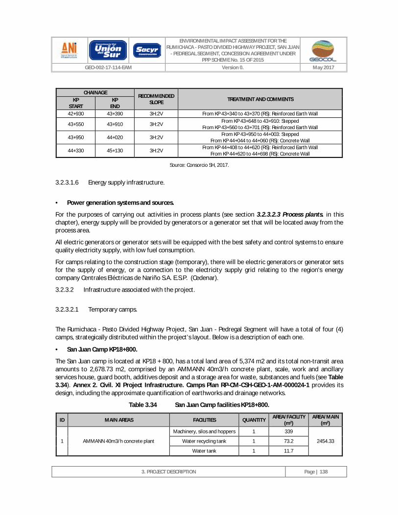
ENVIRONMENTAL IMPACT ASSESSMENT FOR THE RUMICHACA - PASTO DIVIDED HIGHWAY PROJECT, SAN JUAN
- PEDREGAL SEGMENT, CONCESSION AGREEMENT UNDER PPP SCHEME No. 15 OF 2015
GEO-002-17-114-EAM Version 0. May 2017
3. PROJECT DESCRIPTION
Page | 138
CHAINAGE RECOMMENDED
SLOPE TREATMENT AND COMMENTS KP START
KP END
42+930 43+390 3H:2V From KP 43+340 to 43+370 (RS): Reinforced Earth Wall
43+550 43+910 3H:2V From KP 43+648 to 43+910: Stepped From KP 43+560 to 43+701 (RS): Reinforced Earth Wall
43+950 44+020 3H:2V From KP 43+950 to 44+003: Stepped From KP 44+044 to 44+060 (RS): Concrete Wall
44+330 45+130 3H:2V From KP 44+408 to 44+620 (RS): Reinforced Earth Wall From KP 44+620 to 44+698 (RS): Concrete Wall
Source: Consorcio SH, 2017.
3.2.3.1.6 Energy supply infrastructure.
· Power generation systems and sources.
For the purposes of carrying out activities in process plants (see section 3.2.3.2.3 Process plants. in this chapter), energy supply will be provided by generators or a generator set that will be located away from the process area.
All electric generators or generator sets will be equipped with the best safety and control systems to ensure quality electricity supply, with low fuel consumption.
For camps relating to the construction stage (temporary), there will be electric generators or generator sets for the supply of energy, or a connection to the electricity supply grid relating to the region's energy company Centrales Eléctricas de Nariño S.A. E.S.P. (Cedenar).
3.2.3.2 Infrastructure associated with the project.
3.2.3.2.1 Temporary camps.
The Rumichaca - Pasto Divided Highway Project, San Juan - Pedregal Segment will have a total of four (4) camps, strategically distributed within the project’s layout. Below is a description of each one.
· San Juan Camp KP18+800.
The San Juan camp is located at KP18 + 800, has a total land area of 5,374 m2 and its total non-transit area amounts to 2,678.73 m2, comprised by an AMMANN 40m3/h concrete plant, scale, work and ancillary services house, guard booth, additives deposit and a storage area for waste, substances and fuels (see Table 3.34). Annex 2. Civil. XI Project Infrastructure. Camps Plan RP-CM-CSH-GEO-1-AM-000024-1 provides its design, including the approximate quantification of earthworks and drainage networks.
Table 3.34 San Juan Camp facilities KP18+800.
ID MAIN AREAS FACILITIES QUANTITY AREA/FACILITY (m2)
AREA/MAIN (m2)
1 AMMANN 40m3/h concrete plant
Machinery, silos and hoppers 1 339
2454.33 Water recycling tank 1 73.2
Water tank 1 11.7
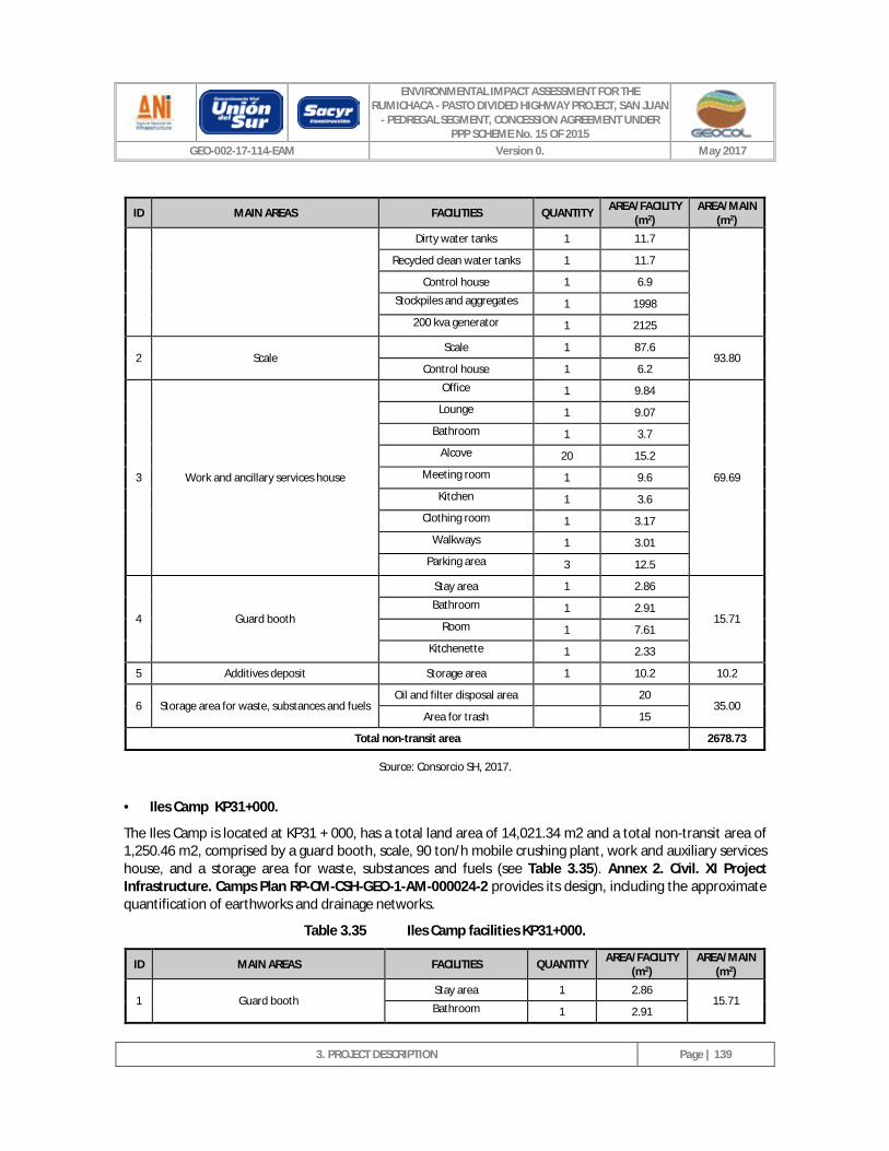
ENVIRONMENTAL IMPACT ASSESSMENT FOR THE RUMICHACA - PASTO DIVIDED HIGHWAY PROJECT, SAN JUAN
- PEDREGAL SEGMENT, CONCESSION AGREEMENT UNDER PPP SCHEME No. 15 OF 2015
GEO-002-17-114-EAM Version 0. May 2017
3. PROJECT DESCRIPTION
Page | 139
ID MAIN AREAS FACILITIES QUANTITY AREA/FACILITY (m2)
AREA/MAIN (m2)
Dirty water tanks 1 11.7
Recycled clean water tanks 1 11.7
Control house 1 6.9
Stockpiles and aggregates 1 1998
200 kva generator 1 2125
2 Scale Scale 1 87.6
93.80 Control house 1 6.2
3 Work and ancillary services house
Office 1 9.84
69.69
Lounge 1 9.07
Bathroom 1 3.7
Alcove 20 15.2
Meeting room 1 9.6
Kitchen 1 3.6
Clothing room 1 3.17
Walkways 1 3.01
Parking area 3 12.5
4 Guard booth
Stay area 1 2.86
15.71 Bathroom 1 2.91
Room 1 7.61
Kitchenette 1 2.33
5 Additives deposit Storage area 1 10.2 10.2
6 Storage area for waste, substances and fuels Oil and filter disposal area 20
35.00 Area for trash 15
Total non-transit area 2678.73
Source: Consorcio SH, 2017.
· Iles Camp KP31+000.
The Iles Camp is located at KP31 + 000, has a total land area of 14,021.34 m2 and a total non-transit area of 1,250.46 m2, comprised by a guard booth, scale, 90 ton/h mobile crushing plant, work and auxiliary services house, and a storage area for waste, substances and fuels (see Table 3.35). Annex 2. Civil. XI Project Infrastructure. Camps Plan RP-CM-CSH-GEO-1-AM-000024-2 provides its design, including the approximate quantification of earthworks and drainage networks.
Table 3.35 Iles Camp facilities KP31+000.
ID MAIN AREAS FACILITIES QUANTITY AREA/FACILITY (m2)
AREA/MAIN (m2)
1 Guard booth Stay area 1 2.86
15.71 Bathroom 1 2.91
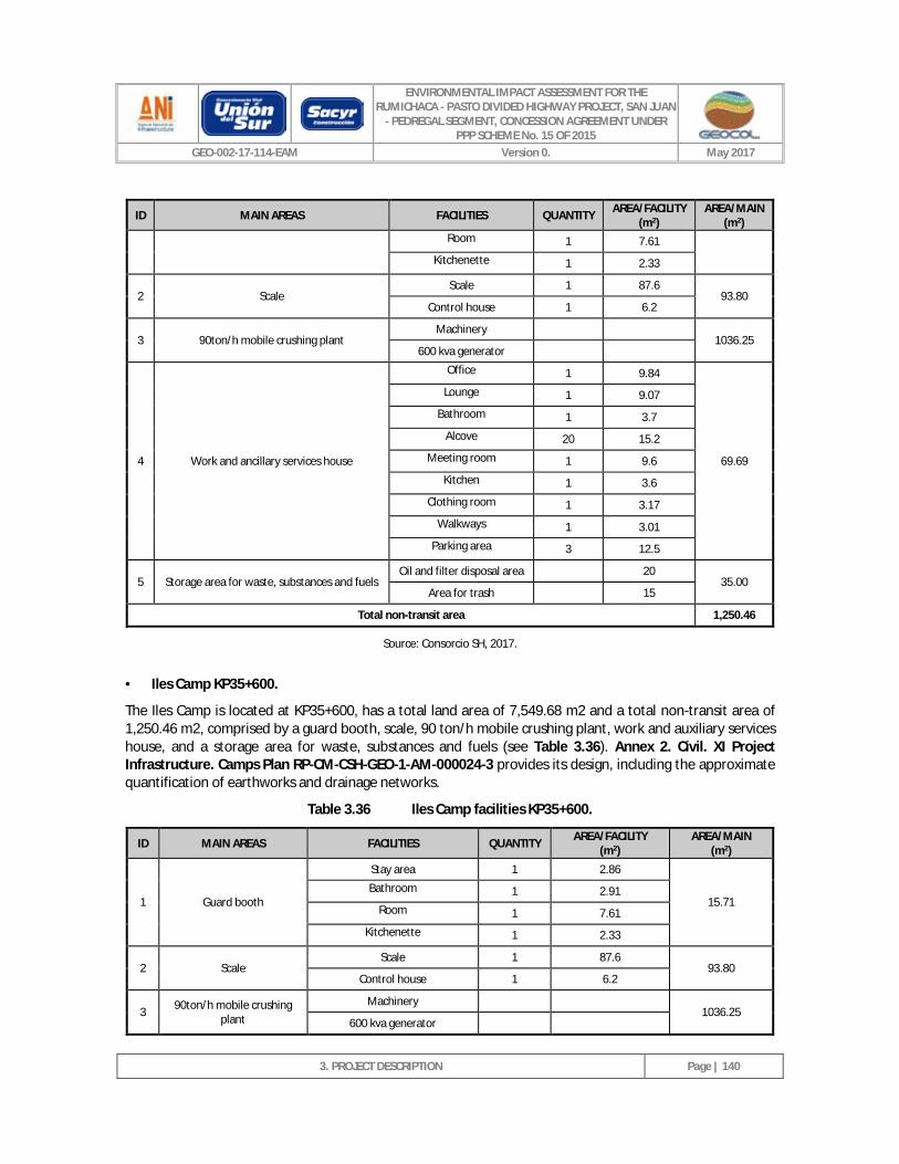
ENVIRONMENTAL IMPACT ASSESSMENT FOR THE RUMICHACA - PASTO DIVIDED HIGHWAY PROJECT, SAN JUAN
- PEDREGAL SEGMENT, CONCESSION AGREEMENT UNDER PPP SCHEME No. 15 OF 2015
GEO-002-17-114-EAM Version 0. May 2017
3. PROJECT DESCRIPTION
Page | 140
ID MAIN AREAS FACILITIES QUANTITY AREA/FACILITY (m2)
AREA/MAIN (m2)
Room 1 7.61
Kitchenette 1 2.33
2 Scale Scale 1 87.6
93.80 Control house 1 6.2
3 90ton/h mobile crushing plant Machinery
1036.25 600 kva generator
4 Work and ancillary services house
Office 1 9.84
69.69
Lounge 1 9.07
Bathroom 1 3.7
Alcove 20 15.2
Meeting room 1 9.6
Kitchen 1 3.6
Clothing room 1 3.17
Walkways 1 3.01
Parking area 3 12.5
5 Storage area for waste, substances and fuels Oil and filter disposal area 20
35.00 Area for trash 15
Total non-transit area 1,250.46
Source: Consorcio SH, 2017.
· Iles Camp KP35+600.
The Iles Camp is located at KP35+600, has a total land area of 7,549.68 m2 and a total non-transit area of 1,250.46 m2, comprised by a guard booth, scale, 90 ton/h mobile crushing plant, work and auxiliary services house, and a storage area for waste, substances and fuels (see Table 3.36). Annex 2. Civil. XI Project Infrastructure. Camps Plan RP-CM-CSH-GEO-1-AM-000024-3 provides its design, including the approximate quantification of earthworks and drainage networks.
Table 3.36 Iles Camp facilities KP35+600.
ID MAIN AREAS FACILITIES QUANTITY AREA/FACILITY (m2)
AREA/MAIN (m2)
1 Guard booth
Stay area 1 2.86
15.71 Bathroom 1 2.91
Room 1 7.61
Kitchenette 1 2.33
2 Scale Scale 1 87.6
93.80 Control house 1 6.2
3 90ton/h mobile crushing plant
Machinery 1036.25
600 kva generator
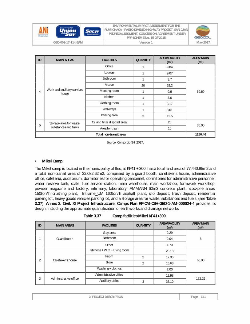
ENVIRONMENTAL IMPACT ASSESSMENT FOR THE RUMICHACA - PASTO DIVIDED HIGHWAY PROJECT, SAN JUAN
- PEDREGAL SEGMENT, CONCESSION AGREEMENT UNDER PPP SCHEME No. 15 OF 2015
GEO-002-17-114-EAM Version 0. May 2017
3. PROJECT DESCRIPTION
Page | 141
ID MAIN AREAS FACILITIES QUANTITY AREA/FACILITY (m2)
AREA/MAIN (m2)
4 Work and ancillary services house
Office 1 9.84
69.69
Lounge 1 9.07
Bathroom 1 3.7
Alcove 20 15.2
Meeting room 1 9.6
Kitchen 1 3.6
Clothing room 1 3.17
Walkways 1 3.01
Parking area 3 12.5
5 Storage area for waste, substances and fuels
Oil and filter disposal area 20 35.00
Area for trash 15
Total non-transit area 1250.46
Source: Consorcio SH, 2017.
· Mikel Camp.
The Mikel camp is located in the municipality of Iles, at KP41 + 300, has a total land area of 77,440.95m2 and a total non-transit area of 32,082.62m2, comprised by a guard booth, caretaker's house, administrative office, cafeteria, auditorium, dormitories for operating personnel, dormitories for administrative personnel, water reserve tank, scale, fuel service station, main warehouse, main workshop, formwork workshop, powder magazine and factory, infirmary, laboratory, AMMANN 60m3 concrete plant, stockpile areas, 150ton/h crushing plant, Intrame_UM 160ton/h asphalt plant, silo deposit, trash deposit, residential parking lot, heavy goods vehicles parking lot, and a storage area for waste, substances and fuels (see Table 3.37). Annex 2. Civil. XI Project Infrastructure. Camps Plan RP-CM-CSH-GEO-1-AM-000024-4 provides its design, including the approximate quantification of earthworks and drainage networks.
Table 3.37 Camp facilities Mikel KP41+300.
ID MAIN AREAS FACILITIES QUANTITY AREA/FACILITY (m2)
AREA/MAIN (m2)
1 Guard booth
Stay area 2.29
6 Bathroom 2.04
Other 1.70
2 Caretaker's house
Kitchens + W.C. + Living room 23.18
66.00 Room 2 17.36
Store 2 15.68
Washing + clothes 2.00
3 Administrative office Administrative office 12.98
172.25 Auxiliary office 3 38.10
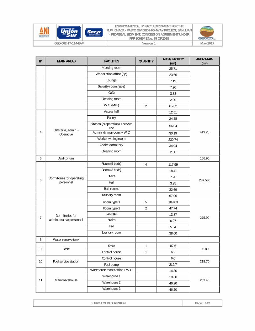
ENVIRONMENTAL IMPACT ASSESSMENT FOR THE RUMICHACA - PASTO DIVIDED HIGHWAY PROJECT, SAN JUAN
- PEDREGAL SEGMENT, CONCESSION AGREEMENT UNDER PPP SCHEME No. 15 OF 2015
GEO-002-17-114-EAM Version 0. May 2017
3. PROJECT DESCRIPTION
Page | 142
ID MAIN AREAS FACILITIES QUANTITY AREA/FACILITY (m2)
AREA/MAIN (m2)
Meeting room 25.71
Workstation office (6p) 23.66
Lounge 7.19
Security room (safe) 7.90
Café 3.38
Cleaning room 2.00
W.C. (M/F) 2 6.762
4 Cafeteria, Admin + Operative
Access hall 12.51
419.28
Pantry 24.38
Kitchen (preparation) + service line 56.04
Admin. dining room. + W.C. 30.19
Worker wining room 230.74
Cooks' dormitory 34.04
Cleaning room 2.00
5 Auditorium 166.90
6 Dormitories for operating personnel
Room (5 beds) 4 117.99
287.536
Room (3 beds) 18.41
Stairs 7.26
Hall 3.95
Bathrooms 32.69
Laundry room 67.06
7 Dormitories for administrative personnel
Room type 1 5 109.63
275.99
Room type 2 2 47.74
Lounge 13.87
Stairs 6.27
Hall 5.64
Laundry room 38.60
8 Water reserve tank
9 Scale Scale 1 87.6
93.80 Control house 1 6.2
10 Fuel service station Control house 6.0
218.70 Fuel pump 212.7
11 Main warehouse
Warehouse man's office + W.C. 14.80
253.40 Warehouse 1 10.60
Warehouse 2 46.20
Warehouse 3 46.20
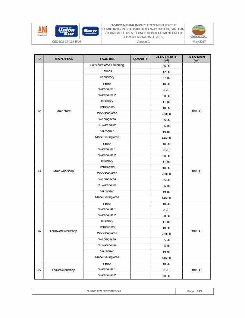
ENVIRONMENTAL IMPACT ASSESSMENT FOR THE RUMICHACA - PASTO DIVIDED HIGHWAY PROJECT, SAN JUAN
- PEDREGAL SEGMENT, CONCESSION AGREEMENT UNDER PPP SCHEME No. 15 OF 2015
GEO-002-17-114-EAM Version 0. May 2017
3. PROJECT DESCRIPTION
Page | 143
ID MAIN AREAS FACILITIES QUANTITY AREA/FACILITY (m2)
AREA/MAIN (m2)
Bathroom area + cleaning 35.00
Pumps 12.00
Depository 67.40
12 Main store
Office 10.20
848.30
Warehouse 1 8.70
Warehouse 2 20.80
Infirmary 11.40
Bathrooms 10.00
Workshop area 230.00
Welding area 55.20
Oil warehouse 36.10
Vulcanizer 19.40
Maneuvering area 446.50
13 Main workshop
Office 10.20
848.30
Warehouse 1 8.70
Warehouse 2 20.80
Infirmary 11.40
Bathrooms 10.00
Workshop area 230.00
Welding area 55.20
Oil warehouse 36.10
Vulcanizer 19.40
Maneuvering area 446.50
14 Formwork workshop
Office 10.20
848.30
Warehouse 1 8.70
Warehouse 2 20.80
Infirmary 11.40
Bathrooms 10.00
Workshop area 230.00
Welding area 55.20
Oil warehouse 36.10
Vulcanizer 19.40
Maneuvering area 446.50
15 Ferrata workshop
Office 10.20
848.30 Warehouse 1 8.70
Warehouse 2 20.80
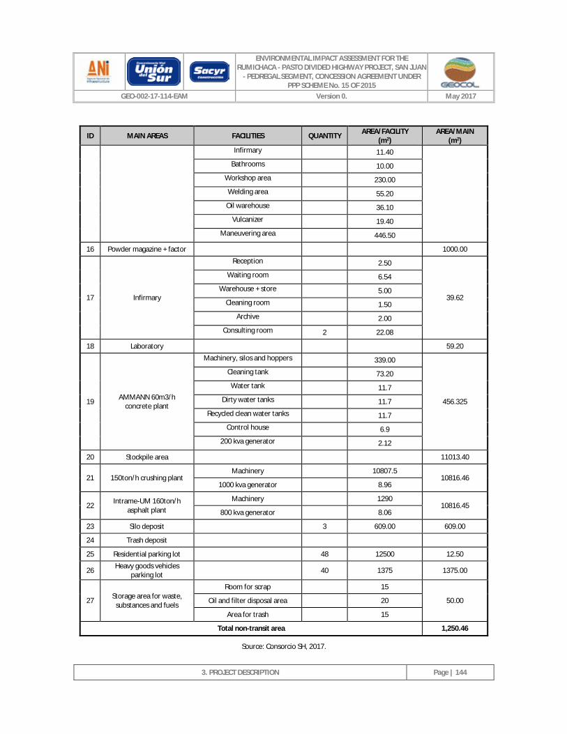
ENVIRONMENTAL IMPACT ASSESSMENT FOR THE RUMICHACA - PASTO DIVIDED HIGHWAY PROJECT, SAN JUAN
- PEDREGAL SEGMENT, CONCESSION AGREEMENT UNDER PPP SCHEME No. 15 OF 2015
GEO-002-17-114-EAM Version 0. May 2017
3. PROJECT DESCRIPTION
Page | 144
ID MAIN AREAS FACILITIES QUANTITY AREA/FACILITY (m2)
AREA/MAIN (m2)
Infirmary 11.40
Bathrooms 10.00
Workshop area 230.00
Welding area 55.20
Oil warehouse 36.10
Vulcanizer 19.40
Maneuvering area 446.50
16 Powder magazine + factor 1000.00
17 Infirmary
Reception 2.50
39.62
Waiting room 6.54
Warehouse + store 5.00
Cleaning room 1.50
Archive 2.00
Consulting room 2 22.08
18 Laboratory 59.20
19 AMMANN 60m3/h concrete plant
Machinery, silos and hoppers 339.00
456.325
Cleaning tank 73.20
Water tank 11.7
Dirty water tanks 11.7
Recycled clean water tanks 11.7
Control house 6.9
200 kva generator 2.12
20 Stockpile area 11013.40
21 150ton/h crushing plant Machinery 10807.5
10816.46 1000 kva generator 8.96
22 Intrame-UM 160ton/h asphalt plant
Machinery 1290 10816.45
800 kva generator 8.06
23 Silo deposit 3 609.00 609.00
24 Trash deposit
25 Residential parking lot 48 12500 12.50
26 Heavy goods vehicles parking lot 40 1375 1375.00
27 Storage area for waste, substances and fuels
Room for scrap 15
50.00 Oil and filter disposal area 20
Area for trash 15
Total non-transit area 1,250.46
Source: Consorcio SH, 2017.
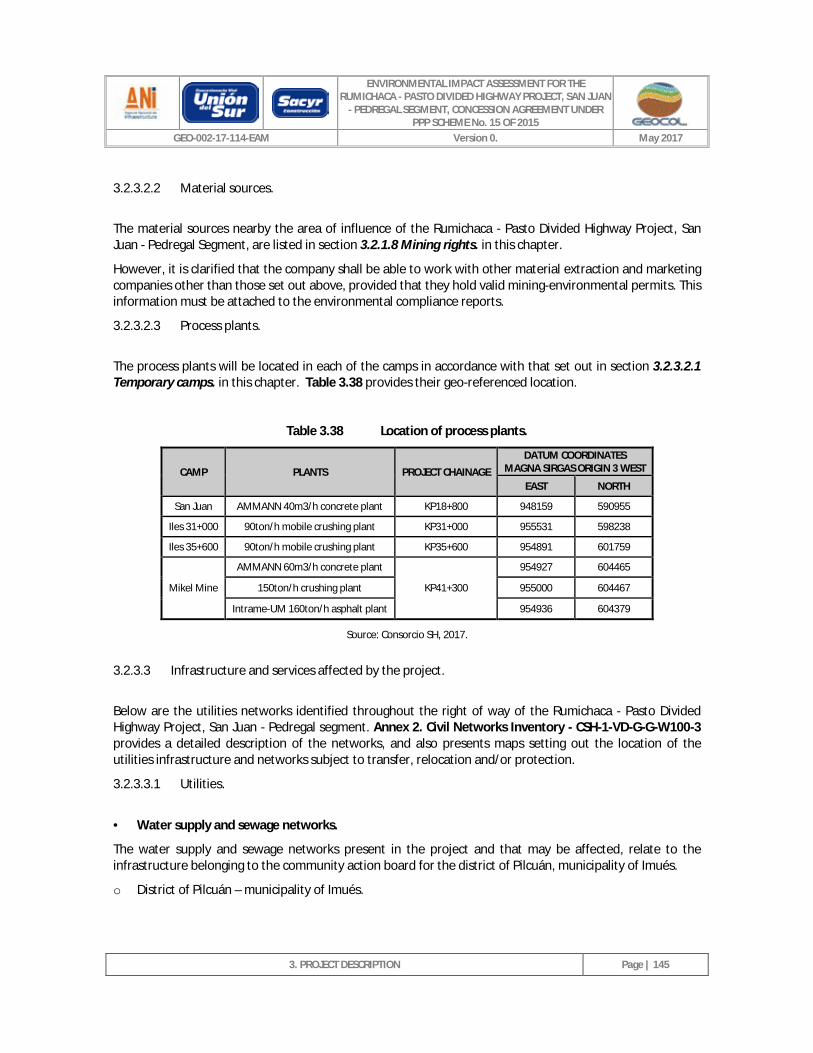
ENVIRONMENTAL IMPACT ASSESSMENT FOR THE RUMICHACA - PASTO DIVIDED HIGHWAY PROJECT, SAN JUAN
- PEDREGAL SEGMENT, CONCESSION AGREEMENT UNDER PPP SCHEME No. 15 OF 2015
GEO-002-17-114-EAM Version 0. May 2017
3. PROJECT DESCRIPTION
Page | 145
3.2.3.2.2 Material sources.
The material sources nearby the area of influence of the Rumichaca - Pasto Divided Highway Project, San Juan - Pedregal Segment, are listed in section 3.2.1.8 Mining rights. in this chapter.
However, it is clarified that the company shall be able to work with other material extraction and marketing companies other than those set out above, provided that they hold valid mining-environmental permits. This information must be attached to the environmental compliance reports.
3.2.3.2.3 Process plants.
The process plants will be located in each of the camps in accordance with that set out in section 3.2.3.2.1 Temporary camps. in this chapter. Table 3.38 provides their geo-referenced location.
Table 3.38 Location of process plants.
CAMP PLANTS PROJECT CHAINAGE DATUM COORDINATES
MAGNA SIRGAS ORIGIN 3 WEST EAST NORTH
San Juan AMMANN 40m3/h concrete plant KP18+800 948159 590955 Iles 31+000 90ton/h mobile crushing plant KP31+000 955531 598238 Iles 35+600 90ton/h mobile crushing plant KP35+600 954891 601759
Mikel Mine AMMANN 60m3/h concrete plant
KP41+300 954927 604465
150ton/h crushing plant 955000 604467 Intrame-UM 160ton/h asphalt plant 954936 604379
Source: Consorcio SH, 2017.
3.2.3.3 Infrastructure and services affected by the project.
Below are the utilities networks identified throughout the right of way of the Rumichaca - Pasto Divided Highway Project, San Juan - Pedregal segment. Annex 2. Civil Networks Inventory - CSH-1-VD-G-G-W100-3 provides a detailed description of the networks, and also presents maps setting out the location of the utilities infrastructure and networks subject to transfer, relocation and/or protection.
3.2.3.3.1 Utilities.
· Water supply and sewage networks.
The water supply and sewage networks present in the project and that may be affected, relate to the infrastructure belonging to the community action board for the district of Pilcuán, municipality of Imués.
o District of Pilcuán – municipality of Imués.
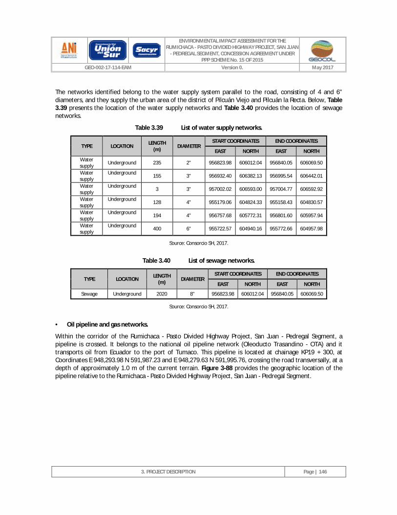
ENVIRONMENTAL IMPACT ASSESSMENT FOR THE RUMICHACA - PASTO DIVIDED HIGHWAY PROJECT, SAN JUAN
- PEDREGAL SEGMENT, CONCESSION AGREEMENT UNDER PPP SCHEME No. 15 OF 2015
GEO-002-17-114-EAM Version 0. May 2017
3. PROJECT DESCRIPTION
Page | 146
The networks identified belong to the water supply system parallel to the road, consisting of 4 and 6" diameters, and they supply the urban area of the district of Pilcuán Viejo and Pilcuán la Recta. Below, Table 3.39 presents the location of the water supply networks and Table 3.40 provides the location of sewage networks.
Table 3.39 List of water supply networks.
TYPE LOCATION LENGTH (m) DIAMETER
START COORDINATES END COORDINATES
EAST NORTH EAST NORTH
Water supply Underground 235 2” 956823.98 606012.04 956840.05 606069.50
Water supply
Underground 155 3” 956932.40 606382.13 956995.54 606442.01
Water supply
Underground 3 3” 957002.02 606593.00 957004.77 606592.92
Water supply
Underground 128 4” 955179.06 604824.33 955158.43 604830.57
Water supply
Underground 194 4” 956757.68 605772.31 956801.60 605957.94
Water supply
Underground 400 6” 955722.57 604940.16 955772.66 604957.98
Source: Consorcio SH, 2017.
Table 3.40 List of sewage networks.
TYPE LOCATION LENGTH (m) DIAMETER
START COORDINATES END COORDINATES
EAST NORTH EAST NORTH
Sewage Underground 2020 8” 956823.98 606012.04 956840.05 606069.50
Source: Consorcio SH, 2017.
· Oil pipeline and gas networks.
Within the corridor of the Rumichaca - Pasto Divided Highway Project, San Juan - Pedregal Segment, a pipeline is crossed. It belongs to the national oil pipeline network (Oleoducto Trasandino - OTA) and it transports oil from Ecuador to the port of Tumaco. This pipeline is located at chainage KP19 + 300, at Coordinates E 948,293.98 N 591,987.23 and E 948,279.63 N 591,995.76, crossing the road transversally, at a depth of approximately 1.0 m of the current terrain. Figure 3-88 provides the geographic location of the pipeline relative to the Rumichaca - Pasto Divided Highway Project, San Juan - Pedregal Segment.
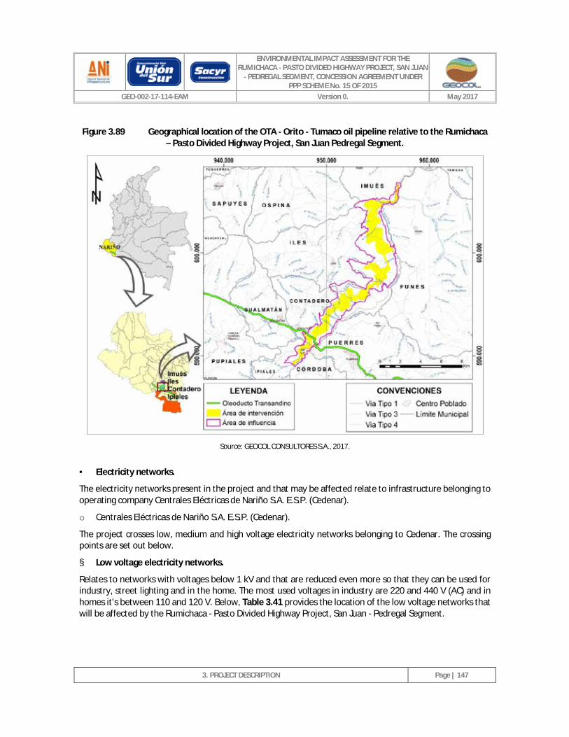
ENVIRONMENTAL IMPACT ASSESSMENT FOR THE RUMICHACA - PASTO DIVIDED HIGHWAY PROJECT, SAN JUAN
- PEDREGAL SEGMENT, CONCESSION AGREEMENT UNDER PPP SCHEME No. 15 OF 2015
GEO-002-17-114-EAM Version 0. May 2017
3. PROJECT DESCRIPTION
Page | 147
Figure 3.89 Geographical location of the OTA - Orito - Tumaco oil pipeline relative to the Rumichaca – Pasto Divided Highway Project, San Juan Pedregal Segment.
Source: GEOCOL CONSULTORES S.A., 2017.
· Electricity networks.
The electricity networks present in the project and that may be affected relate to infrastructure belonging to operating company Centrales Eléctricas de Nariño S.A. E.S.P. (Cedenar).
o Centrales Eléctricas de Nariño S.A. E.S.P. (Cedenar).
The project crosses low, medium and high voltage electricity networks belonging to Cedenar. The crossing points are set out below.
§ Low voltage electricity networks.
Relates to networks with voltages below 1 kV and that are reduced even more so that they can be used for industry, street lighting and in the home. The most used voltages in industry are 220 and 440 V (AC) and in homes it's between 110 and 120 V. Below, Table 3.41 provides the location of the low voltage networks that will be affected by the Rumichaca - Pasto Divided Highway Project, San Juan - Pedregal Segment.
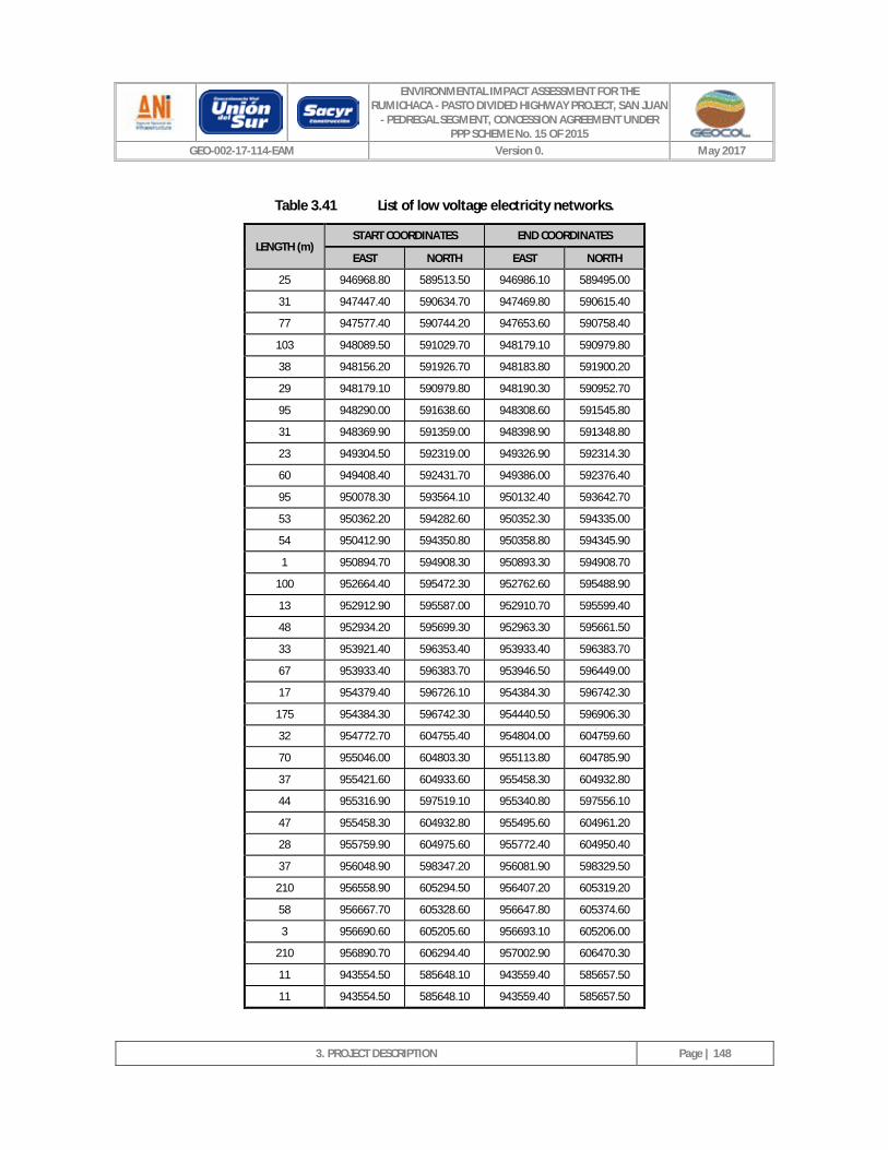
ENVIRONMENTAL IMPACT ASSESSMENT FOR THE RUMICHACA - PASTO DIVIDED HIGHWAY PROJECT, SAN JUAN
- PEDREGAL SEGMENT, CONCESSION AGREEMENT UNDER PPP SCHEME No. 15 OF 2015
GEO-002-17-114-EAM Version 0. May 2017
3. PROJECT DESCRIPTION
Page | 148
Table 3.41 List of low voltage electricity networks.
LENGTH (m) START COORDINATES END COORDINATES
EAST NORTH EAST NORTH
25 946968.80 589513.50 946986.10 589495.00
31 947447.40 590634.70 947469.80 590615.40
77 947577.40 590744.20 947653.60 590758.40
103 948089.50 591029.70 948179.10 590979.80
38 948156.20 591926.70 948183.80 591900.20
29 948179.10 590979.80 948190.30 590952.70
95 948290.00 591638.60 948308.60 591545.80
31 948369.90 591359.00 948398.90 591348.80
23 949304.50 592319.00 949326.90 592314.30
60 949408.40 592431.70 949386.00 592376.40
95 950078.30 593564.10 950132.40 593642.70
53 950362.20 594282.60 950352.30 594335.00
54 950412.90 594350.80 950358.80 594345.90
1 950894.70 594908.30 950893.30 594908.70
100 952664.40 595472.30 952762.60 595488.90
13 952912.90 595587.00 952910.70 595599.40
48 952934.20 595699.30 952963.30 595661.50
33 953921.40 596353.40 953933.40 596383.70
67 953933.40 596383.70 953946.50 596449.00
17 954379.40 596726.10 954384.30 596742.30
175 954384.30 596742.30 954440.50 596906.30
32 954772.70 604755.40 954804.00 604759.60
70 955046.00 604803.30 955113.80 604785.90
37 955421.60 604933.60 955458.30 604932.80
44 955316.90 597519.10 955340.80 597556.10
47 955458.30 604932.80 955495.60 604961.20
28 955759.90 604975.60 955772.40 604950.40
37 956048.90 598347.20 956081.90 598329.50
210 956558.90 605294.50 956407.20 605319.20
58 956667.70 605328.60 956647.80 605374.60
3 956690.60 605205.60 956693.10 605206.00
210 956890.70 606294.40 957002.90 606470.30
11 943554.50 585648.10 943559.40 585657.50
11 943554.50 585648.10 943559.40 585657.50
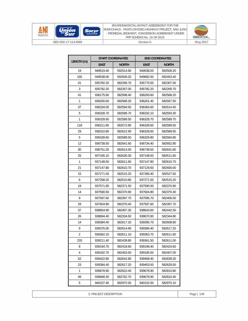
ENVIRONMENTAL IMPACT ASSESSMENT FOR THE RUMICHACA - PASTO DIVIDED HIGHWAY PROJECT, SAN JUAN
- PEDREGAL SEGMENT, CONCESSION AGREEMENT UNDER PPP SCHEME No. 15 OF 2015
GEO-002-17-114-EAM Version 0. May 2017
3. PROJECT DESCRIPTION
Page | 149
LENGTH (m) START COORDINATES END COORDINATES
EAST NORTH EAST NORTH
19 949519.40 592514.90 949538.00 592509.20
155 949538.00 592509.20 949682.50 592453.40
41 935782.20 582269.70 935770.50 582307.50
3 935782.20 582267.00 935782.20 582269.70
41 936175.60 582598.40 936200.60 582568.20
1 936200.60 582568.20 936201.40 582567.50
37 936334.00 582594.50 936364.60 582614.40
5 936328.70 582589.70 936332.10 582593.30
1 936328.60 582589.50 936328.70 582589.70
118 936211.80 582572.80 936328.60 582589.50
29 936310.80 582612.90 936328.60 582589.50
5 936328.60 582589.50 936329.80 582584.80
12 936739.50 582641.60 936734.40 582652.80
30 936751.20 582614.50 936739.50 582641.60
25 937165.10 582630.30 937148.50 582611.60
1 937148.50 582611.60 937147.80 582610.70
21 937147.80 582610.70 937129.50 582600.00
15 937271.50 582515.20 937280.40 582527.50
6 937268.20 582510.80 937271.50 582515.20
19 937571.90 582371.50 937590.50 582370.90
14 937590.50 582370.90 937604.80 582370.40
9 937597.60 582397.70 937595.70 582406.50
29 937604.80 582370.40 937597.60 582397.70
37 938654.90 582407.30 938643.60 582442.50
26 938694.40 582334.50 938670.90 582344.80
14 939384.40 582617.20 939395.70 582608.80
9 939376.00 582614.90 939384.40 582617.20
2 939362.10 582611.10 939363.70 582611.60
233 939211.40 582439.80 939361.50 582611.00
8 939194.70 582418.60 939199.40 582424.60
4 939182.70 582403.50 939185.50 582407.00
52 939422.80 582642.80 939468.40 582639.20
23 939384.40 582617.20 939403.50 582629.50
1 939678.90 582810.40 939678.90 582810.80
49 939668.30 582762.70 939678.90 582810.40
5 940107.40 582972.00 940102.50 582970.10

ENVIRONMENTAL IMPACT ASSESSMENT FOR THE RUMICHACA - PASTO DIVIDED HIGHWAY PROJECT, SAN JUAN
- PEDREGAL SEGMENT, CONCESSION AGREEMENT UNDER PPP SCHEME No. 15 OF 2015
GEO-002-17-114-EAM Version 0. May 2017
3. PROJECT DESCRIPTION
Page | 150
LENGTH (m) START COORDINATES END COORDINATES
EAST NORTH EAST NORTH
19 940074.50 582959.00 940057.30 582952.10
51 940189.10 583093.50 940160.40 583050.80
44 940132.00 583008.60 940107.40 582972.00
15 940899.80 583388.30 940914.50 583389.70
28 940930.00 583389.10 940953.90 583386.00
2 941050.70 583364.30 941052.50 583365.40
41 940965.20 583314.20 941001.10 583333.40
29 941380.30 583631.80 941403.20 583649.10
1 941379.50 583631.20 941380.30 583631.80
153 941257.40 583539.10 941379.50 583631.20
3 941380.30 583631.80 941378.80 583634.50
4 941381.10 583627.50 941380.30 583631.80
9 941381.70 583619.20 941381.10 583627.50
89 941583.40 583783.30 941654.60 583836.30
1 941576.80 583778.10 941576.90 583778.20
49 942823.40 584447.60 942775.00 584454.70
27 942850.20 584444.60 942823.40 584447.60
60 943136.70 584908.60 943165.30 584961.30
3 943135.50 584906.30 943136.70 584908.60
232 943021.20 584704.50 943135.50 584906.30
13 943365.90 585323.30 943378.30 585328.30
1 943365.30 585323.10 943365.90 585323.30
15 943358.50 585309.60 943365.30 585323.10
19 943350.00 585292.90 943358.50 585309.60
4 943488.20 585511.10 943491.70 585510.60
17 943463.30 585503.00 943479.60 585507.40
27 943559.40 585657.50 943572.20 585681.50
104 943509.20 585556.20 943554.50 585648.10
14 943491.90 585510.40 943496.60 585523.70
16 943487.30 585495.00 943491.90 585510.40
1 943491.90 585510.40 943491.70 585510.60
17 943491.60 585494.30 943491.90 585510.40
1 943967.70 587241.40 943967.80 587241.80
46 943963.60 587195.90 943967.70 587241.40
6 943977.00 587331.50 943976.40 587325.90
76 943975.50 587317.40 943967.80 587241.90
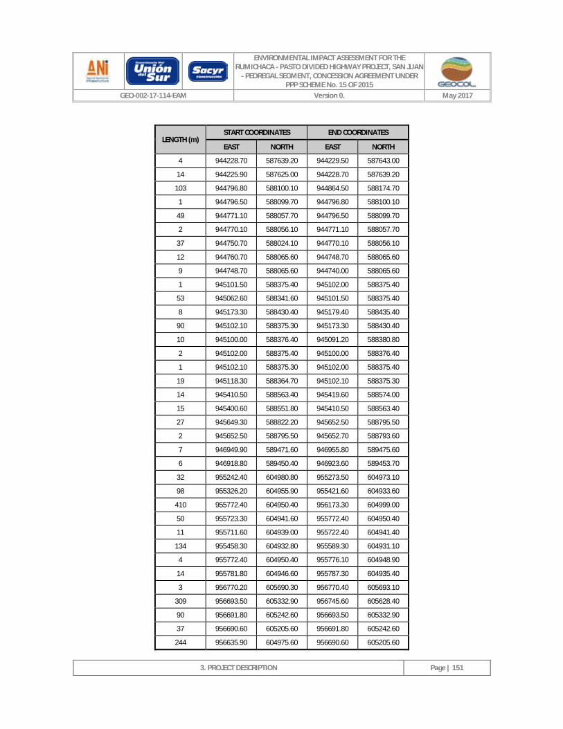
ENVIRONMENTAL IMPACT ASSESSMENT FOR THE RUMICHACA - PASTO DIVIDED HIGHWAY PROJECT, SAN JUAN
- PEDREGAL SEGMENT, CONCESSION AGREEMENT UNDER PPP SCHEME No. 15 OF 2015
GEO-002-17-114-EAM Version 0. May 2017
3. PROJECT DESCRIPTION
Page | 151
LENGTH (m) START COORDINATES END COORDINATES
EAST NORTH EAST NORTH
4 944228.70 587639.20 944229.50 587643.00
14 944225.90 587625.00 944228.70 587639.20
103 944796.80 588100.10 944864.50 588174.70
1 944796.50 588099.70 944796.80 588100.10
49 944771.10 588057.70 944796.50 588099.70
2 944770.10 588056.10 944771.10 588057.70
37 944750.70 588024.10 944770.10 588056.10
12 944760.70 588065.60 944748.70 588065.60
9 944748.70 588065.60 944740.00 588065.60
1 945101.50 588375.40 945102.00 588375.40
53 945062.60 588341.60 945101.50 588375.40
8 945173.30 588430.40 945179.40 588435.40
90 945102.10 588375.30 945173.30 588430.40
10 945100.00 588376.40 945091.20 588380.80
2 945102.00 588375.40 945100.00 588376.40
1 945102.10 588375.30 945102.00 588375.40
19 945118.30 588364.70 945102.10 588375.30
14 945410.50 588563.40 945419.60 588574.00
15 945400.60 588551.80 945410.50 588563.40
27 945649.30 588822.20 945652.50 588795.50
2 945652.50 588795.50 945652.70 588793.60
7 946949.90 589471.60 946955.80 589475.60
6 946918.80 589450.40 946923.60 589453.70
32 955242.40 604980.80 955273.50 604973.10
98 955326.20 604955.90 955421.60 604933.60
410 955772.40 604950.40 956173.30 604999.00
50 955723.30 604941.60 955772.40 604950.40
11 955711.60 604939.00 955722.40 604941.40
134 955458.30 604932.80 955589.30 604931.10
4 955772.40 604950.40 955776.10 604948.90
14 955781.80 604946.60 955787.30 604935.40
3 956770.20 605690.30 956770.40 605693.10
309 956693.50 605332.90 956745.60 605628.40
90 956691.80 605242.60 956693.50 605332.90
37 956690.60 605205.60 956691.80 605242.60
244 956635.90 604975.60 956690.60 605205.60
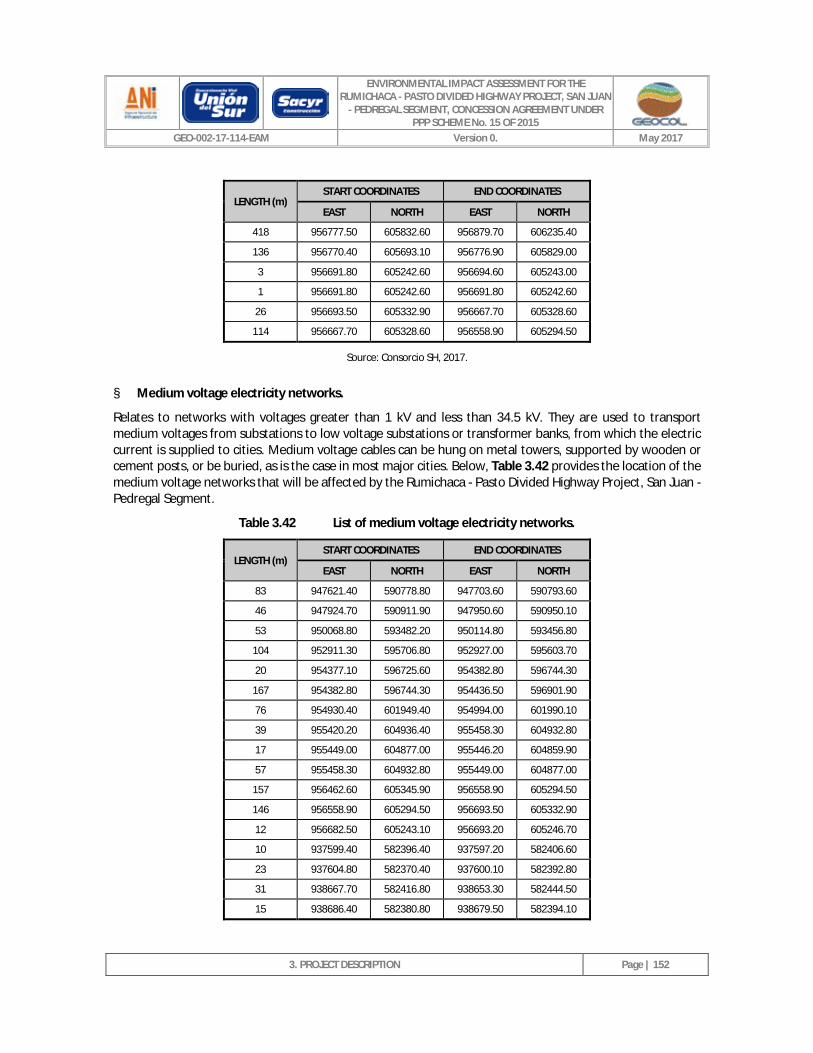
ENVIRONMENTAL IMPACT ASSESSMENT FOR THE RUMICHACA - PASTO DIVIDED HIGHWAY PROJECT, SAN JUAN
- PEDREGAL SEGMENT, CONCESSION AGREEMENT UNDER PPP SCHEME No. 15 OF 2015
GEO-002-17-114-EAM Version 0. May 2017
3. PROJECT DESCRIPTION
Page | 152
LENGTH (m) START COORDINATES END COORDINATES
EAST NORTH EAST NORTH
418 956777.50 605832.60 956879.70 606235.40
136 956770.40 605693.10 956776.90 605829.00
3 956691.80 605242.60 956694.60 605243.00
1 956691.80 605242.60 956691.80 605242.60
26 956693.50 605332.90 956667.70 605328.60
114 956667.70 605328.60 956558.90 605294.50
Source: Consorcio SH, 2017.
§ Medium voltage electricity networks.
Relates to networks with voltages greater than 1 kV and less than 34.5 kV. They are used to transport medium voltages from substations to low voltage substations or transformer banks, from which the electric current is supplied to cities. Medium voltage cables can be hung on metal towers, supported by wooden or cement posts, or be buried, as is the case in most major cities. Below, Table 3.42 provides the location of the medium voltage networks that will be affected by the Rumichaca - Pasto Divided Highway Project, San Juan - Pedregal Segment.
Table 3.42 List of medium voltage electricity networks.
LENGTH (m) START COORDINATES END COORDINATES
EAST NORTH EAST NORTH
83 947621.40 590778.80 947703.60 590793.60
46 947924.70 590911.90 947950.60 590950.10
53 950068.80 593482.20 950114.80 593456.80
104 952911.30 595706.80 952927.00 595603.70
20 954377.10 596725.60 954382.80 596744.30
167 954382.80 596744.30 954436.50 596901.90
76 954930.40 601949.40 954994.00 601990.10
39 955420.20 604936.40 955458.30 604932.80
17 955449.00 604877.00 955446.20 604859.90
57 955458.30 604932.80 955449.00 604877.00
157 956462.60 605345.90 956558.90 605294.50
146 956558.90 605294.50 956693.50 605332.90
12 956682.50 605243.10 956693.20 605246.70
10 937599.40 582396.40 937597.20 582406.60
23 937604.80 582370.40 937600.10 582392.80
31 938667.70 582416.80 938653.30 582444.50
15 938686.40 582380.80 938679.50 582394.10

ENVIRONMENTAL IMPACT ASSESSMENT FOR THE RUMICHACA - PASTO DIVIDED HIGHWAY PROJECT, SAN JUAN
- PEDREGAL SEGMENT, CONCESSION AGREEMENT UNDER PPP SCHEME No. 15 OF 2015
GEO-002-17-114-EAM Version 0. May 2017
3. PROJECT DESCRIPTION
Page | 153
LENGTH (m) START COORDINATES END COORDINATES
EAST NORTH EAST NORTH
113 939419.80 582683.60 939338.00 582746.80
83 939367.00 582624.10 939419.80 582683.60
120 939293.60 582536.90 939367.00 582624.10
42 939367.00 582624.10 939331.00 582645.10
14 939375.10 582614.90 939367.00 582624.10
3 939386.40 582612.60 939383.90 582613.60
2 939392.70 582608.80 939390.60 582610.10
58 939419.90 582683.80 939458.00 582727.50
1 939419.80 582683.60 939419.90 582683.80
7 940666.10 583280.20 940666.20 583287.10
23 940647.40 583266.30 940666.10 583280.20
213 940436.60 583243.40 940647.40 583266.30
49 940666.10 583280.20 940714.80 583281.90
10 940655.90 583279.60 940666.10 583280.20
93 940563.40 583273.70 940655.90 583279.60
3 940522.70 583271.10 940526.00 583271.30
16 940504.80 583270.00 940520.60 583271.00
4 940480.20 583268.40 940484.30 583268.70
24 941639.30 583807.60 941658.80 583821.60
68 941584.30 583768.00 941639.30 583807.60
1 941584.20 583768.00 941584.30 583768.00
251 941381.70 583619.20 941584.20 583768.00
263 941168.00 583466.20 941381.70 583619.20
25 941146.10 583457.20 941168.00 583466.20
5 941141.70 583455.30 941146.10 583457.20
36 941112.40 583436.00 941141.70 583455.30
70 941023.80 583397.30 941082.20 583420.30
13 940965.80 583386.60 940978.90 583388.30
5 940960.60 583386.00 940965.80 583386.60
37 942168.20 584194.80 942199.00 584215.80
13 942137.70 584177.70 942149.40 584182.00
597 941658.80 583821.60 942137.70 584177.70
21 941661.60 583818.10 941678.00 583804.60
14 941678.00 583804.60 941689.10 583795.60
28 942130.50 584261.10 942153.00 584275.60
3 942129.80 584257.80 942130.50 584261.10
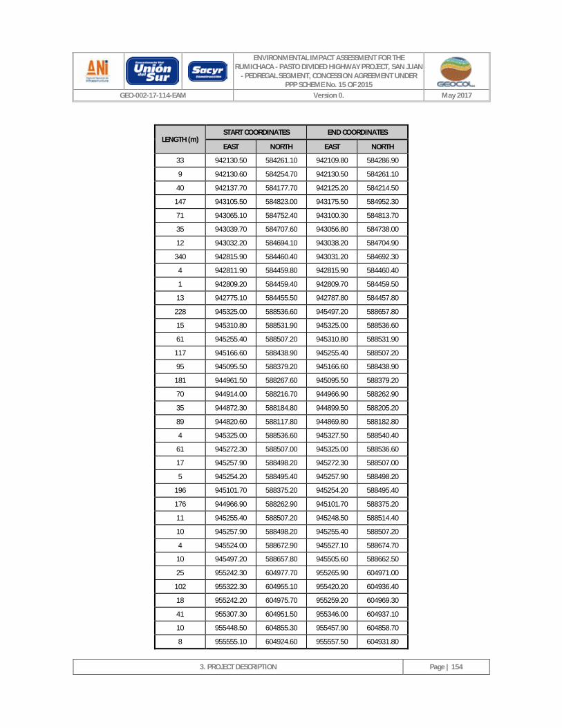
ENVIRONMENTAL IMPACT ASSESSMENT FOR THE RUMICHACA - PASTO DIVIDED HIGHWAY PROJECT, SAN JUAN
- PEDREGAL SEGMENT, CONCESSION AGREEMENT UNDER PPP SCHEME No. 15 OF 2015
GEO-002-17-114-EAM Version 0. May 2017
3. PROJECT DESCRIPTION
Page | 154
LENGTH (m) START COORDINATES END COORDINATES
EAST NORTH EAST NORTH
33 942130.50 584261.10 942109.80 584286.90
9 942130.60 584254.70 942130.50 584261.10
40 942137.70 584177.70 942125.20 584214.50
147 943105.50 584823.00 943175.50 584952.30
71 943065.10 584752.40 943100.30 584813.70
35 943039.70 584707.60 943056.80 584738.00
12 943032.20 584694.10 943038.20 584704.90
340 942815.90 584460.40 943031.20 584692.30
4 942811.90 584459.80 942815.90 584460.40
1 942809.20 584459.40 942809.70 584459.50
13 942775.10 584455.50 942787.80 584457.80
228 945325.00 588536.60 945497.20 588657.80
15 945310.80 588531.90 945325.00 588536.60
61 945255.40 588507.20 945310.80 588531.90
117 945166.60 588438.90 945255.40 588507.20
95 945095.50 588379.20 945166.60 588438.90
181 944961.50 588267.60 945095.50 588379.20
70 944914.00 588216.70 944966.90 588262.90
35 944872.30 588184.80 944899.50 588205.20
89 944820.60 588117.80 944869.80 588182.80
4 945325.00 588536.60 945327.50 588540.40
61 945272.30 588507.00 945325.00 588536.60
17 945257.90 588498.20 945272.30 588507.00
5 945254.20 588495.40 945257.90 588498.20
196 945101.70 588375.20 945254.20 588495.40
176 944966.90 588262.90 945101.70 588375.20
11 945255.40 588507.20 945248.50 588514.40
10 945257.90 588498.20 945255.40 588507.20
4 945524.00 588672.90 945527.10 588674.70
10 945497.20 588657.80 945505.60 588662.50
25 955242.30 604977.70 955265.90 604971.00
102 955322.30 604955.10 955420.20 604936.40
18 955242.20 604975.70 955259.20 604969.30
41 955307.30 604951.50 955346.00 604937.10
10 955448.50 604855.30 955457.90 604858.70
8 955555.10 604924.60 955557.50 604931.80
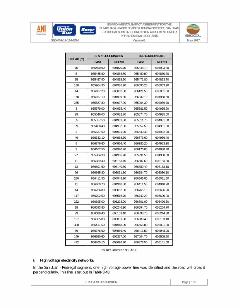
ENVIRONMENTAL IMPACT ASSESSMENT FOR THE RUMICHACA - PASTO DIVIDED HIGHWAY PROJECT, SAN JUAN
- PEDREGAL SEGMENT, CONCESSION AGREEMENT UNDER PPP SCHEME No. 15 OF 2015
GEO-002-17-114-EAM Version 0. May 2017
3. PROJECT DESCRIPTION
Page | 155
LENGTH (m) START COORDINATES END COORDINATES
EAST NORTH EAST NORTH
70 955490.90 604870.70 955548.10 604903.30
5 955485.90 604868.80 955490.90 604870.70
15 955457.90 604858.70 955471.80 604863.70
130 955964.30 604986.70 956090.20 605003.20
14 956107.20 605002.30 956121.50 605001.60
178 956157.10 604999.80 956332.10 604968.50
285 955687.80 604937.00 955964.30 604986.70
3 955679.00 604935.40 955681.50 604935.90
29 955646.00 604932.70 955674.70 604935.00
55 955557.50 604931.80 955611.70 604931.60
99 955458.40 604932.90 955557.50 604931.80
3 955637.60 604931.90 955640.40 604932.20
46 956332.10 604968.50 956376.60 604956.40
5 956376.60 604956.40 956380.20 604953.30
9 956167.50 604990.20 956176.00 604988.90
27 955964.30 604986.70 955991.50 604988.50
11 956689.40 605153.10 956687.60 605163.80
13 956691.60 605140.50 956689.40 605153.10
26 956665.80 605031.80 956684.70 605050.10
280 956411.50 604948.90 956665.80 605031.80
11 956400.70 604948.00 956411.50 604948.90
44 956756.80 605652.80 956765.10 605696.20
117 956702.50 605516.70 956742.20 605620.00
222 956695.00 605278.00 956701.00 605496.30
18 956693.80 605246.90 956694.70 605264.70
93 956689.40 605153.10 956693.70 605244.30
127 956665.80 605031.80 956689.40 605153.10
300 956411.50 604948.90 956665.80 605031.80
36 956376.60 604956.40 956411.50 604948.90
149 956950.60 606367.00 957004.70 606505.50
472 956765.10 605696.20 956878.50 606141.60
Source: Consorcio SH, 2017.
§ High voltage electricity networks.
In the San Juan - Pedregal segment, one high voltage power line was identified and the road will cross it perpendicularly. This line is set out in Table 3.43.
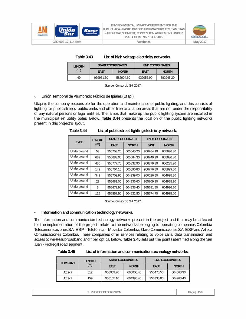
ENVIRONMENTAL IMPACT ASSESSMENT FOR THE RUMICHACA - PASTO DIVIDED HIGHWAY PROJECT, SAN JUAN
- PEDREGAL SEGMENT, CONCESSION AGREEMENT UNDER PPP SCHEME No. 15 OF 2015
GEO-002-17-114-EAM Version 0. May 2017
3. PROJECT DESCRIPTION
Page | 156
Table 3.43 List of high voltage electricity networks.
LENGTH (m)
START COORDINATES END COORDINATES
EAST NORTH EAST NORTH
49 939981.30 582904.60 939953.90 582945.20
Source: Consorcio SH, 2017.
o Unión Temporal de Alumbrado Público de Ipiales (Utapi)
Utapi is the company responsible for the operation and maintenance of public lighting, and this consists of lighting for public streets, public parks and other free circulation areas that are not under the responsibility of any natural persons or legal entities. The lamps that make up the public lighting system are installed in the municipalities' utility poles. Below, Table 3.44 presents the location of the public lighting networks present in this project's layout.
Table 3.44 List of public street lighting electricity network.
TYPE LENGTH (m)
START COORDINATES END COORDINATES
EAST NORTH EAST NORTH
Underground 53 956753.20 605645.20 956764.10 605696.80
Underground 632 956683.00 605064.30 956749.20 605636.80
Underground 430 956777.70 605832.90 956879.80 606235.90
Underground 142 956764.10 605696.80 956776.80 605829.80
Underground 342 955709.90 604939.00 956026.80 604998.80
Underground 29 955682.00 604936.60 955709.30 604938.90
Underground 3 955678.90 604935.40 955681.50 604936.50
Underground 119 955557.50 604931.80 955674.70 604935.00
Source: Consorcio SH, 2017.
· Information and communication technology networks.
The information and communication technology networks present in the project and that may be affected for the implementation of the project, relate to the networks belonging to operating companies Colombia Telecomunicaciones S.A. E.S.P – Telefónica – Movistar Colombia, Claro Comunicaciones S.A. E.S.P and Azteca Comunicaciones Colombia. These companies offer services relating to voice calls, data transmission and access to wireless broadband and fiber optics. Below, Table 3.45 sets out the points identified along the San Juan - Pedregal road segment.
Table 3.45 List of information and communication technology networks.
COMPANY LENGTH (m)
START COORDINATES END COORDINATES
EAST NORTH EAST NORTH
Azteca 312 956069.70 605006.40 955470.50 604868.30
Azteca 159 956165.10 604995.40 956335.80 604963.40
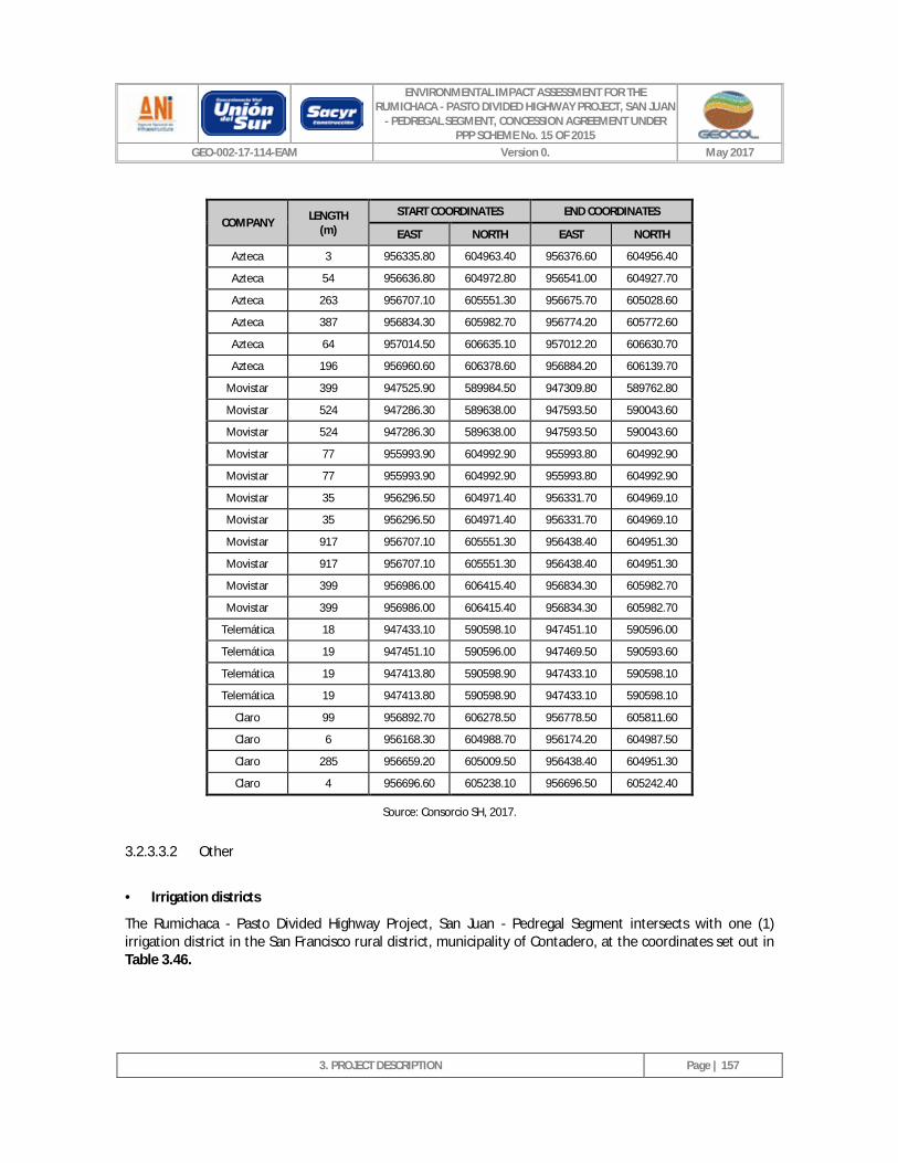
ENVIRONMENTAL IMPACT ASSESSMENT FOR THE RUMICHACA - PASTO DIVIDED HIGHWAY PROJECT, SAN JUAN
- PEDREGAL SEGMENT, CONCESSION AGREEMENT UNDER PPP SCHEME No. 15 OF 2015
GEO-002-17-114-EAM Version 0. May 2017
3. PROJECT DESCRIPTION
Page | 157
COMPANY LENGTH (m)
START COORDINATES END COORDINATES
EAST NORTH EAST NORTH
Azteca 3 956335.80 604963.40 956376.60 604956.40
Azteca 54 956636.80 604972.80 956541.00 604927.70
Azteca 263 956707.10 605551.30 956675.70 605028.60
Azteca 387 956834.30 605982.70 956774.20 605772.60
Azteca 64 957014.50 606635.10 957012.20 606630.70
Azteca 196 956960.60 606378.60 956884.20 606139.70
Movistar 399 947525.90 589984.50 947309.80 589762.80
Movistar 524 947286.30 589638.00 947593.50 590043.60
Movistar 524 947286.30 589638.00 947593.50 590043.60
Movistar 77 955993.90 604992.90 955993.80 604992.90
Movistar 77 955993.90 604992.90 955993.80 604992.90
Movistar 35 956296.50 604971.40 956331.70 604969.10
Movistar 35 956296.50 604971.40 956331.70 604969.10
Movistar 917 956707.10 605551.30 956438.40 604951.30
Movistar 917 956707.10 605551.30 956438.40 604951.30
Movistar 399 956986.00 606415.40 956834.30 605982.70
Movistar 399 956986.00 606415.40 956834.30 605982.70
Telemática 18 947433.10 590598.10 947451.10 590596.00
Telemática 19 947451.10 590596.00 947469.50 590593.60
Telemática 19 947413.80 590598.90 947433.10 590598.10
Telemática 19 947413.80 590598.90 947433.10 590598.10
Claro 99 956892.70 606278.50 956778.50 605811.60
Claro 6 956168.30 604988.70 956174.20 604987.50
Claro 285 956659.20 605009.50 956438.40 604951.30
Claro 4 956696.60 605238.10 956696.50 605242.40
Source: Consorcio SH, 2017.
3.2.3.3.2 Other
· Irrigation districts
The Rumichaca - Pasto Divided Highway Project, San Juan - Pedregal Segment intersects with one (1) irrigation district in the San Francisco rural district, municipality of Contadero, at the coordinates set out in Table 3.46.
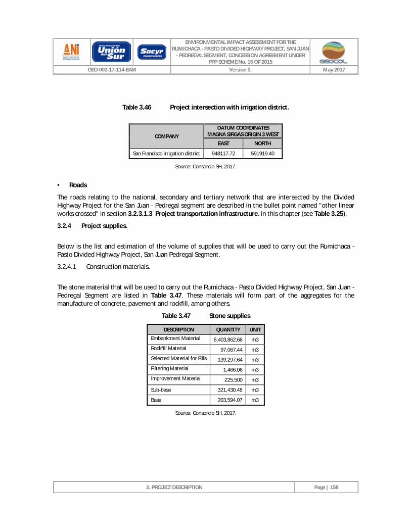
ENVIRONMENTAL IMPACT ASSESSMENT FOR THE RUMICHACA - PASTO DIVIDED HIGHWAY PROJECT, SAN JUAN
- PEDREGAL SEGMENT, CONCESSION AGREEMENT UNDER PPP SCHEME No. 15 OF 2015
GEO-002-17-114-EAM Version 0. May 2017
3. PROJECT DESCRIPTION
Page | 158
Table 3.46 Project intersection with irrigation district.
COMPANY
DATUM COORDINATES MAGNA SIRGAS ORIGIN 3 WEST
EAST NORTH
San Francisco irrigation district 948117.72 591919.40
Source: Consorcio SH, 2017.
· Roads
The roads relating to the national, secondary and tertiary network that are intersected by the Divided Highway Project for the San Juan - Pedregal segment are described in the bullet point named "other linear works crossed" in section 3.2.3.1.3 Project transportation infrastructure. in this chapter (see Table 3.25).
3.2.4 Project supplies.
Below is the list and estimation of the volume of supplies that will be used to carry out the Rumichaca - Pasto Divided Highway Project, San Juan Pedregal Segment.
3.2.4.1 Construction materials.
The stone material that will be used to carry out the Rumichaca - Pasto Divided Highway Project, San Juan - Pedregal Segment are listed in Table 3.47. These materials will form part of the aggregates for the manufacture of concrete, pavement and rockfill, among others.
Table 3.47 Stone supplies
DESCRIPTION QUANTITY UNIT
Embankment Material 6,403,862.66 m3
Rockfill Material 97,067.44 m3
Selected Material for Fills 139,297.64 m3
Filtering Material 1,466.06 m3
Improvement Material 225,500 m3
Sub-base 321,430.48 m3
Base 203,594.07 m3
Source: Consorcio SH, 2017.
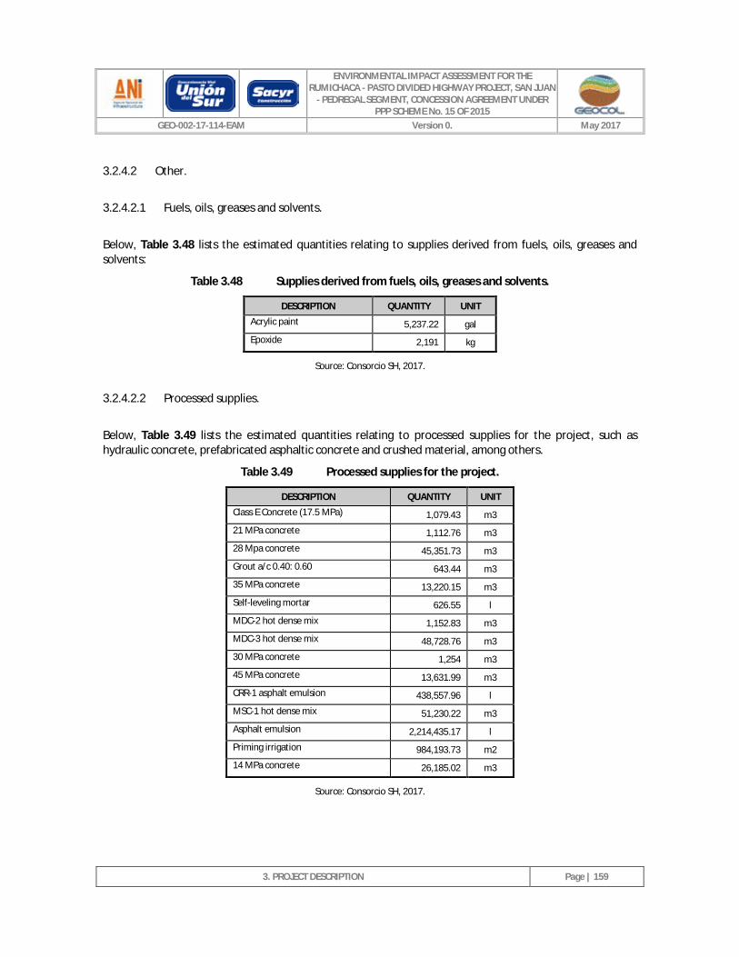
ENVIRONMENTAL IMPACT ASSESSMENT FOR THE RUMICHACA - PASTO DIVIDED HIGHWAY PROJECT, SAN JUAN
- PEDREGAL SEGMENT, CONCESSION AGREEMENT UNDER PPP SCHEME No. 15 OF 2015
GEO-002-17-114-EAM Version 0. May 2017
3. PROJECT DESCRIPTION
Page | 159
3.2.4.2 Other.
3.2.4.2.1 Fuels, oils, greases and solvents.
Below, Table 3.48 lists the estimated quantities relating to supplies derived from fuels, oils, greases and solvents:
Table 3.48 Supplies derived from fuels, oils, greases and solvents.
DESCRIPTION QUANTITY UNIT
Acrylic paint 5,237.22 gal
Epoxide 2,191 kg
Source: Consorcio SH, 2017.
3.2.4.2.2 Processed supplies.
Below, Table 3.49 lists the estimated quantities relating to processed supplies for the project, such as hydraulic concrete, prefabricated asphaltic concrete and crushed material, among others.
Table 3.49 Processed supplies for the project.
DESCRIPTION QUANTITY UNIT
Class E Concrete (17.5 MPa) 1,079.43 m3
21 MPa concrete 1,112.76 m3
28 Mpa concrete 45,351.73 m3
Grout a/c 0.40: 0.60 643.44 m3
35 MPa concrete 13,220.15 m3
Self-leveling mortar 626.55 l
MDC-2 hot dense mix 1,152.83 m3
MDC-3 hot dense mix 48,728.76 m3
30 MPa concrete 1,254 m3
45 MPa concrete 13,631.99 m3
CRR-1 asphalt emulsion 438,557.96 l
MSC-1 hot dense mix 51,230.22 m3
Asphalt emulsion 2,214,435.17 l
Priming irrigation 984,193.73 m2
14 MPa concrete 26,185.02 m3
Source: Consorcio SH, 2017.
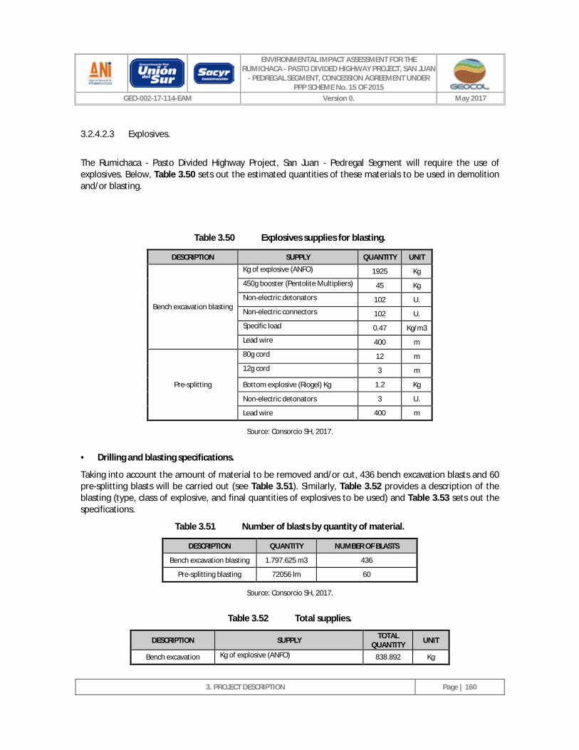
ENVIRONMENTAL IMPACT ASSESSMENT FOR THE RUMICHACA - PASTO DIVIDED HIGHWAY PROJECT, SAN JUAN
- PEDREGAL SEGMENT, CONCESSION AGREEMENT UNDER PPP SCHEME No. 15 OF 2015
GEO-002-17-114-EAM Version 0. May 2017
3. PROJECT DESCRIPTION
Page | 160
3.2.4.2.3 Explosives.
The Rumichaca - Pasto Divided Highway Project, San Juan - Pedregal Segment will require the use of explosives. Below, Table 3.50 sets out the estimated quantities of these materials to be used in demolition and/or blasting.
Table 3.50 Explosives supplies for blasting.
DESCRIPTION SUPPLY QUANTITY UNIT
Bench excavation blasting
Kg of explosive (ANFO) 1925 Kg
450g booster (Pentolite Multipliers) 45 Kg
Non-electric detonators 102 U.
Non-electric connectors 102 U.
Specific load 0.47 Kg/m3
Lead wire 400 m
Pre-splitting
80g cord 12 m
12g cord 3 m
Bottom explosive (Riogel) Kg 1.2 Kg
Non-electric detonators 3 U.
Lead wire 400 m
Source: Consorcio SH, 2017.
· Drilling and blasting specifications.
Taking into account the amount of material to be removed and/or cut, 436 bench excavation blasts and 60 pre-splitting blasts will be carried out (see Table 3.51). Similarly, Table 3.52 provides a description of the blasting (type, class of explosive, and final quantities of explosives to be used) and Table 3.53 sets out the specifications.
Table 3.51 Number of blasts by quantity of material.
DESCRIPTION QUANTITY NUMBER OF BLASTS
Bench excavation blasting 1.797.625 m3 436
Pre-splitting blasting 72056 lm 60
Source: Consorcio SH, 2017.
Table 3.52 Total supplies.
DESCRIPTION SUPPLY TOTAL QUANTITY UNIT
Bench excavation Kg of explosive (ANFO) 838.892 Kg
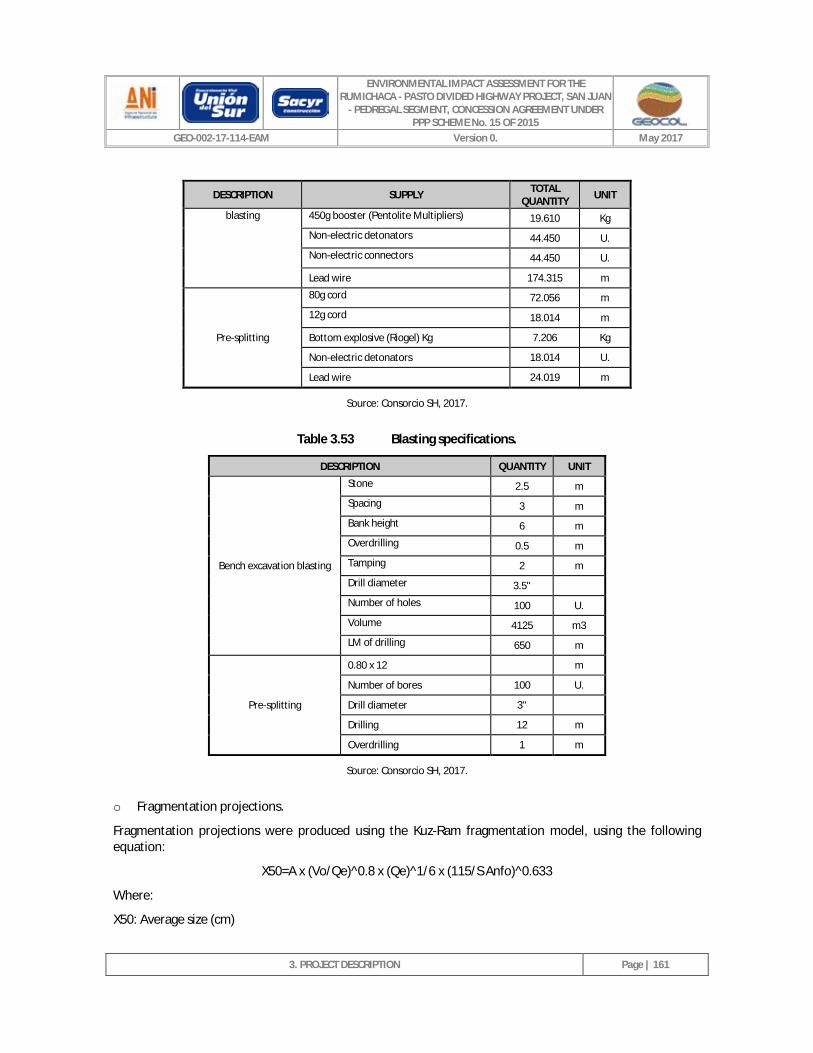
ENVIRONMENTAL IMPACT ASSESSMENT FOR THE RUMICHACA - PASTO DIVIDED HIGHWAY PROJECT, SAN JUAN
- PEDREGAL SEGMENT, CONCESSION AGREEMENT UNDER PPP SCHEME No. 15 OF 2015
GEO-002-17-114-EAM Version 0. May 2017
3. PROJECT DESCRIPTION
Page | 161
DESCRIPTION SUPPLY TOTAL QUANTITY UNIT
blasting 450g booster (Pentolite Multipliers) 19.610 Kg
Non-electric detonators 44.450 U.
Non-electric connectors 44.450 U.
Lead wire 174.315 m
Pre-splitting
80g cord 72.056 m
12g cord 18.014 m
Bottom explosive (Riogel) Kg 7.206 Kg
Non-electric detonators 18.014 U.
Lead wire 24.019 m
Source: Consorcio SH, 2017.
Table 3.53 Blasting specifications.
DESCRIPTION QUANTITY UNIT
Bench excavation blasting
Stone 2.5 m
Spacing 3 m
Bank height 6 m
Overdrilling 0.5 m
Tamping 2 m
Drill diameter 3.5"
Number of holes 100 U.
Volume 4125 m3
LM of drilling 650 m
Pre-splitting
0.80 x 12 m
Number of bores 100 U.
Drill diameter 3"
Drilling 12 m
Overdrilling 1 m
Source: Consorcio SH, 2017.
o Fragmentation projections.
Fragmentation projections were produced using the Kuz-Ram fragmentation model, using the following equation:
X50=A x (Vo/Qe)^0.8 x (Qe)^1/6 x (115/S Anfo)^0.633
Where:
X50: Average size (cm)
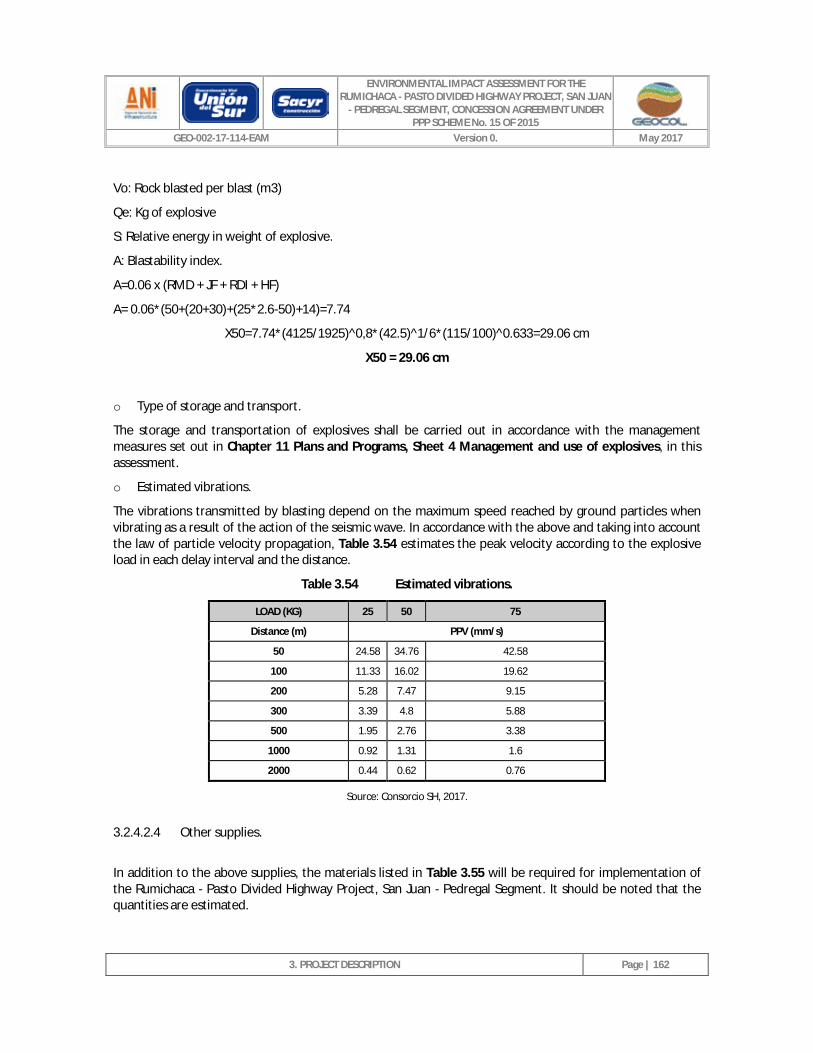
ENVIRONMENTAL IMPACT ASSESSMENT FOR THE RUMICHACA - PASTO DIVIDED HIGHWAY PROJECT, SAN JUAN
- PEDREGAL SEGMENT, CONCESSION AGREEMENT UNDER PPP SCHEME No. 15 OF 2015
GEO-002-17-114-EAM Version 0. May 2017
3. PROJECT DESCRIPTION
Page | 162
Vo: Rock blasted per blast (m3)
Qe: Kg of explosive
S: Relative energy in weight of explosive.
A: Blastability index.
A=0.06 x (RMD + JF + RDI + HF)
A= 0.06*(50+(20+30)+(25*2.6-50)+14)=7.74
X50=7.74*(4125/1925)^0,8*(42.5)^1/6*(115/100)^0.633=29.06 cm
X50 = 29.06 cm
o Type of storage and transport.
The storage and transportation of explosives shall be carried out in accordance with the management measures set out in Chapter 11 Plans and Programs, Sheet 4 Management and use of explosives, in this assessment.
o Estimated vibrations.
The vibrations transmitted by blasting depend on the maximum speed reached by ground particles when vibrating as a result of the action of the seismic wave. In accordance with the above and taking into account the law of particle velocity propagation, Table 3.54 estimates the peak velocity according to the explosive load in each delay interval and the distance.
Table 3.54 Estimated vibrations.
LOAD (KG) 25 50 75
Distance (m) PPV (mm/s)
50 24.58 34.76 42.58
100 11.33 16.02 19.62
200 5.28 7.47 9.15
300 3.39 4.8 5.88
500 1.95 2.76 3.38
1000 0.92 1.31 1.6
2000 0.44 0.62 0.76
Source: Consorcio SH, 2017.
3.2.4.2.4 Other supplies.
In addition to the above supplies, the materials listed in Table 3.55 will be required for implementation of the Rumichaca - Pasto Divided Highway Project, San Juan - Pedregal Segment. It should be noted that the quantities are estimated.
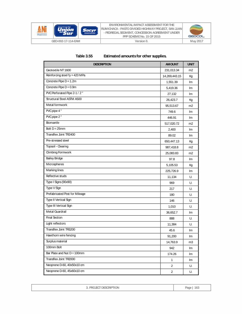
ENVIRONMENTAL IMPACT ASSESSMENT FOR THE RUMICHACA - PASTO DIVIDED HIGHWAY PROJECT, SAN JUAN
- PEDREGAL SEGMENT, CONCESSION AGREEMENT UNDER PPP SCHEME No. 15 OF 2015
GEO-002-17-114-EAM Version 0. May 2017
3. PROJECT DESCRIPTION
Page | 163
Table 3.55 Estimated amounts for other supplies.
DESCRIPTION AMOUNT UNIT
Geotextile NT 1600 231,013.34 m2
Reinforcing steel fy = 420 MPa 14,269,443.15 Kg
Concrete Pipe D = 1.2m 1,551.39 lm
Concrete Pipe D = 0.9m 5,419.36 lm
PVC Perforated Pipe 2-1 / 2 " 27,132 lm
Structural Steel ASTM A500 26,423.7 Kg
Metal formwork 95,513.67 m2
PVC pipe 4 " 749.6 lm
PVC pipe 2 " 446.91 lm
Biomantle 517,020.72 m2
Bolt D = 25mm 2,400 lm
Transflex Joint TR2400 89.02 lm
Pre-stressed steel 650,447.13 Kg
Topsoil - Clearing 987,418.8 m2
Climbing Formwork 25,083.83 m2
Bailey Bridge 97.8 lm
Microspheres 5,105.53 Kg
Marking lines 225,726.9 lm
Reflective studs 11,134 U.
Type I Signs (90x90) 969 U.
Type V Sign 217 U.
Prefabricated Post for Mileage 180 U.
Type II Vertical Sign 146 U.
Type III Vertical Sign 1,010 U.
Metal Guardrail 36,652.7 lm
Final Section 888 U.
Light reflectors 11,384 U.
Transflex Joint TR3200 45.6 lm
Hawthorn wire fencing 91,200 lm
Surplus material 14,763.9 m3
100mm Bolt 942 lm
Bar Plate and Nut D = 100mm 174.26 lm
Transflex Joint TR2000 1 lm
Neoprene D-60, 40x50x10 cm 2 U.
Neoprene D-60, 45x60x10 cm 2 U.
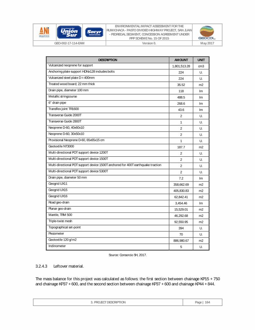
ENVIRONMENTAL IMPACT ASSESSMENT FOR THE RUMICHACA - PASTO DIVIDED HIGHWAY PROJECT, SAN JUAN
- PEDREGAL SEGMENT, CONCESSION AGREEMENT UNDER PPP SCHEME No. 15 OF 2015
GEO-002-17-114-EAM Version 0. May 2017
3. PROJECT DESCRIPTION
Page | 164
DESCRIPTION AMOUNT UNIT
Vulcanized neoprene for support 1,801,513.28 cm3
Anchoring plate support HDNx128 includes bolts 224 U.
Vulcanized steel plate D = 400mm 224 U.
Treated wood board; 22 mm thick 35.52 m2
Drain pipe, diameter 100 mm 118 lm
Metallic stringcourse 488.5 lm
6" drain pipe 268.6 lm
Transflex joint TR1600 43.6 lm
Transverse Guide 2000T 2 U.
Transverse Guide 2800T 1 U.
Neoprene D-60, 40x60x10 2 U.
Neoprene D-60, 30x50x10 2 U.
Provisional Neoprene D-60, 65x65x15 cm 1 U.
Geotextile NT3000 187.7 m2
Multi-directional POT support device 1200T 2 U.
Multi-directional POT support device 1500T 2 U.
Multi-directional POT support device 1500T anchored for 400T earthquake traction 2 U.
Multi-directional POT support device 5300T 2 U.
Drain pipe, diameter 50 mm 7.2 lm
Geogrid UX11 358,662.69 m2
Geogrid UX15 405,830.83 m2
Geogrid UX16 62,842.41 m2
Road geo-drain 3,454.46 lm
Planar geo-drain 15,529.01 m2
Mantle, TRM 500 46,292.68 m2
Triple-twist mesh 92,550.95 m2
Topographical set-point 394 U.
Piezometer 70 U.
Geotextile 120 g/m2 886,980.67 m2
Inclinometer 5 U.
Source: Consorcio SH, 2017.
3.2.4.3 Leftover material.
The mass balance for this project was calculated as follows: the first section between chainage KP15 + 750 and chainage KP37 + 600, and the second section between chainage KP37 + 600 and chainage KP44 + 844.
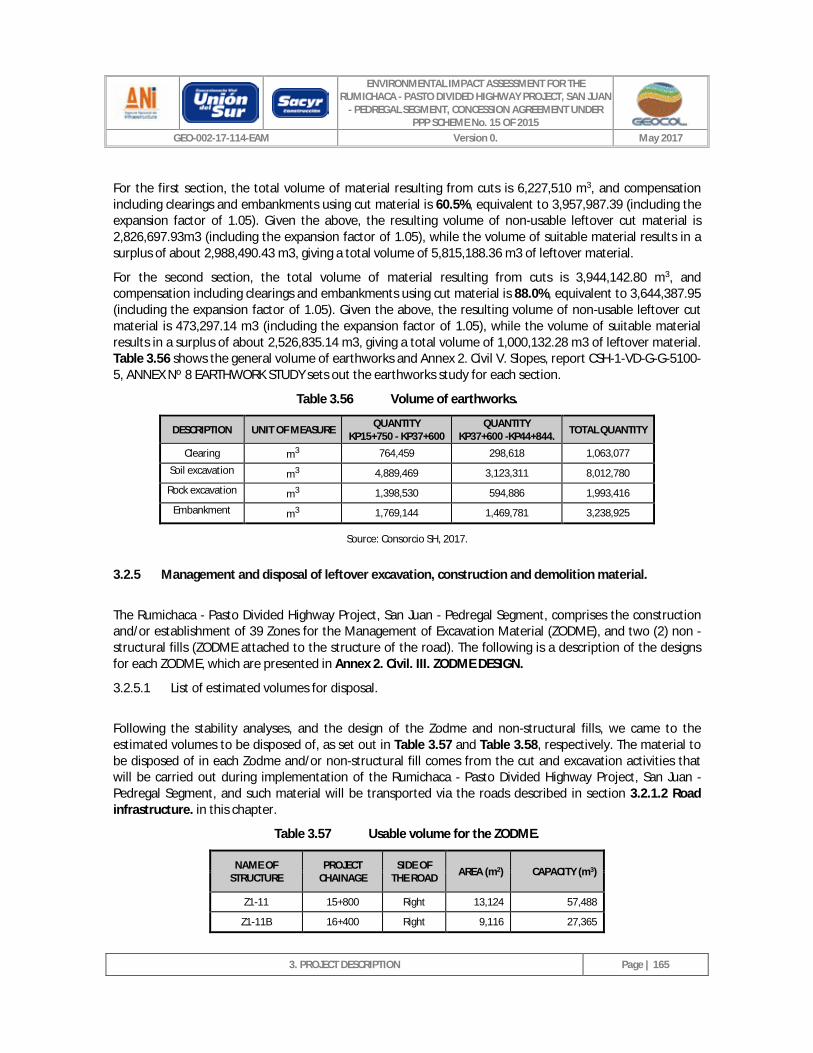
ENVIRONMENTAL IMPACT ASSESSMENT FOR THE RUMICHACA - PASTO DIVIDED HIGHWAY PROJECT, SAN JUAN
- PEDREGAL SEGMENT, CONCESSION AGREEMENT UNDER PPP SCHEME No. 15 OF 2015
GEO-002-17-114-EAM Version 0. May 2017
3. PROJECT DESCRIPTION
Page | 165
For the first section, the total volume of material resulting from cuts is 6,227,510 m3, and compensation including clearings and embankments using cut material is 60.5%, equivalent to 3,957,987.39 (including the expansion factor of 1.05). Given the above, the resulting volume of non-usable leftover cut material is 2,826,697.93m3 (including the expansion factor of 1.05), while the volume of suitable material results in a surplus of about 2,988,490.43 m3, giving a total volume of 5,815,188.36 m3 of leftover material.
For the second section, the total volume of material resulting from cuts is 3,944,142.80 m3, and compensation including clearings and embankments using cut material is 88.0%, equivalent to 3,644,387.95 (including the expansion factor of 1.05). Given the above, the resulting volume of non-usable leftover cut material is 473,297.14 m3 (including the expansion factor of 1.05), while the volume of suitable material results in a surplus of about 2,526,835.14 m3, giving a total volume of 1,000,132.28 m3 of leftover material. Table 3.56 shows the general volume of earthworks and Annex 2. Civil V. Slopes, report CSH-1-VD-G-G-5100-5, ANNEX Nº 8 EARTHWORK STUDY sets out the earthworks study for each section.
Table 3.56 Volume of earthworks.
DESCRIPTION UNIT OF MEASURE QUANTITY KP15+750 - KP37+600
QUANTITY KP37+600 -KP44+844. TOTAL QUANTITY
Clearing m3 764,459 298,618 1,063,077
Soil excavation m3 4,889,469 3,123,311 8,012,780
Rock excavation m3 1,398,530 594,886 1,993,416
Embankment m3 1,769,144 1,469,781 3,238,925
Source: Consorcio SH, 2017.
3.2.5 Management and disposal of leftover excavation, construction and demolition material.
The Rumichaca - Pasto Divided Highway Project, San Juan - Pedregal Segment, comprises the construction and/or establishment of 39 Zones for the Management of Excavation Material (ZODME), and two (2) non - structural fills (ZODME attached to the structure of the road). The following is a description of the designs for each ZODME, which are presented in Annex 2. Civil. III. ZODME DESIGN.
3.2.5.1 List of estimated volumes for disposal.
Following the stability analyses, and the design of the Zodme and non-structural fills, we came to the estimated volumes to be disposed of, as set out in Table 3.57 and Table 3.58, respectively. The material to be disposed of in each Zodme and/or non-structural fill comes from the cut and excavation activities that will be carried out during implementation of the Rumichaca - Pasto Divided Highway Project, San Juan - Pedregal Segment, and such material will be transported via the roads described in section 3.2.1.2 Road infrastructure. in this chapter.
Table 3.57 Usable volume for the ZODME.
NAME OF STRUCTURE
PROJECT CHAINAGE
SIDE OF THE ROAD AREA (m2) CAPACITY (m3)
Z1-11 15+800 Right 13,124 57,488
Z1-11B 16+400 Right 9,116 27,365
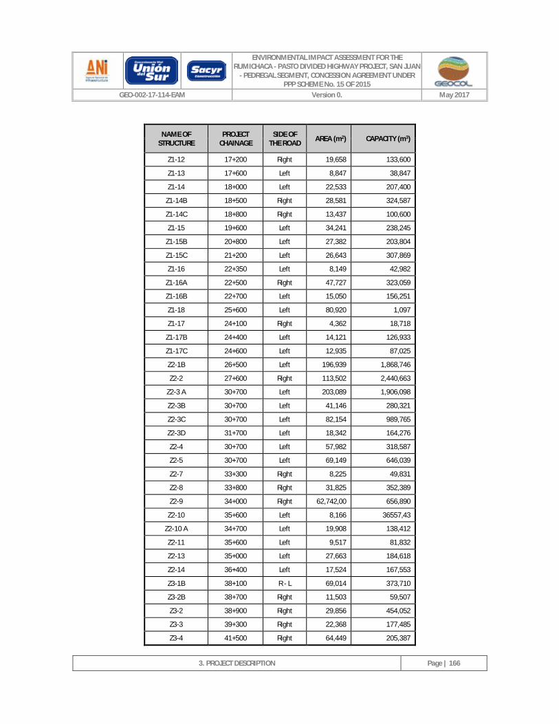
ENVIRONMENTAL IMPACT ASSESSMENT FOR THE RUMICHACA - PASTO DIVIDED HIGHWAY PROJECT, SAN JUAN
- PEDREGAL SEGMENT, CONCESSION AGREEMENT UNDER PPP SCHEME No. 15 OF 2015
GEO-002-17-114-EAM Version 0. May 2017
3. PROJECT DESCRIPTION
Page | 166
NAME OF STRUCTURE
PROJECT CHAINAGE
SIDE OF THE ROAD AREA (m2) CAPACITY (m3)
Z1-12 17+200 Right 19,658 133,600
Z1-13 17+600 Left 8,847 38,847
Z1-14 18+000 Left 22,533 207,400
Z1-14B 18+500 Right 28,581 324,587
Z1-14C 18+800 Right 13,437 100,600
Z1-15 19+600 Left 34,241 238,245
Z1-15B 20+800 Left 27,382 203,804
Z1-15C 21+200 Left 26,643 307,869
Z1-16 22+350 Left 8,149 42,982
Z1-16A 22+500 Right 47,727 323,059
Z1-16B 22+700 Left 15,050 156,251
Z1-18 25+600 Left 80,920 1,097
Z1-17 24+100 Right 4,362 18,718
Z1-17B 24+400 Left 14,121 126,933
Z1-17C 24+600 Left 12,935 87,025
Z2-1B 26+500 Left 196,939 1,868,746
Z2-2 27+600 Right 113,502 2,440,663
Z2-3 A 30+700 Left 203,089 1,906,098
Z2-3B 30+700 Left 41,146 280,321
Z2-3C 30+700 Left 82,154 989,765
Z2-3D 31+700 Left 18,342 164,276
Z2-4 30+700 Left 57,982 318,587
Z2-5 30+700 Left 69,149 646,039
Z2-7 33+300 Right 8,225 49,831
Z2-8 33+800 Right 31,825 352,389
Z2-9 34+000 Right 62,742,00 656,890
Z2-10 35+600 Left 8,166 36557,43
Z2-10 A 34+700 Left 19,908 138,412
Z2-11 35+600 Left 9,517 81,832
Z2-13 35+000 Left 27,663 184,618
Z2-14 36+400 Left 17,524 167,553
Z3-1B 38+100 R - L 69,014 373,710
Z3-2B 38+700 Right 11,503 59,507
Z3-2 38+900 Right 29,856 454,052
Z3-3 39+300 Right 22,368 177,485
Z3-4 41+500 Right 64,449 205,387
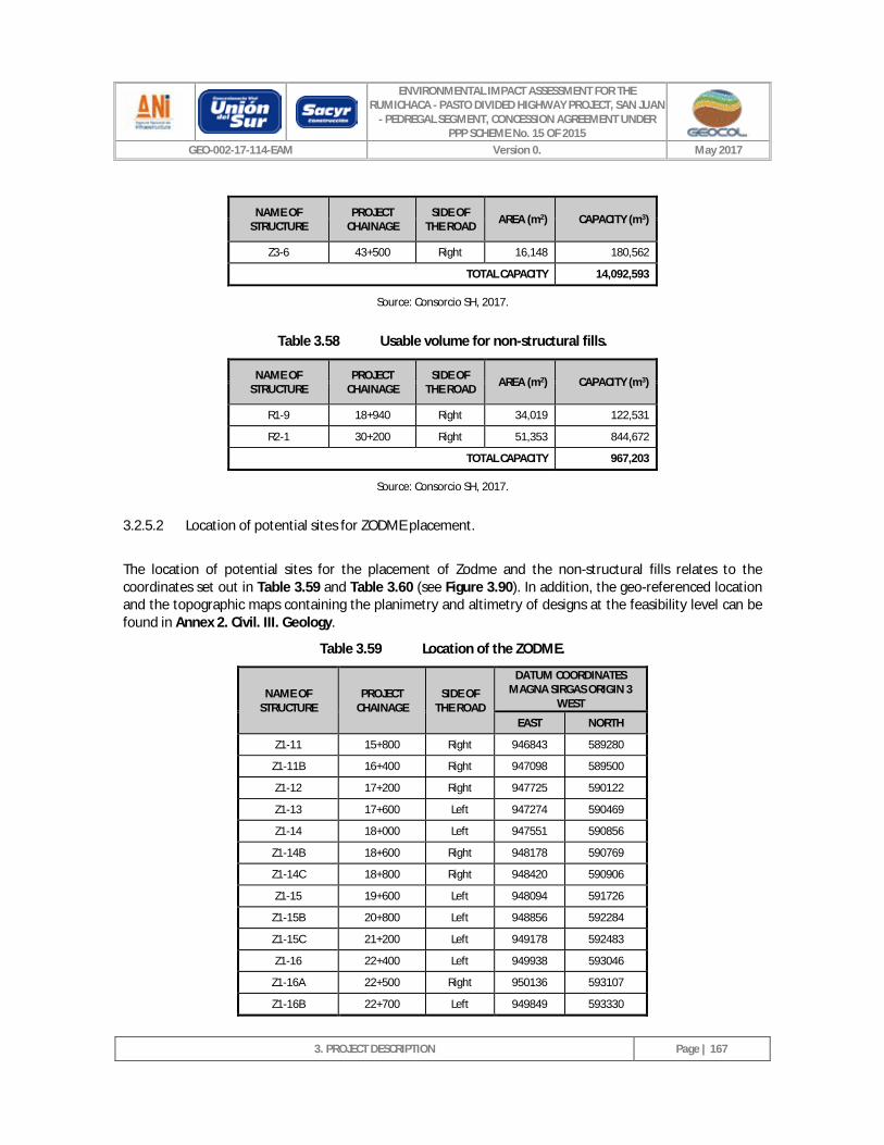
ENVIRONMENTAL IMPACT ASSESSMENT FOR THE RUMICHACA - PASTO DIVIDED HIGHWAY PROJECT, SAN JUAN
- PEDREGAL SEGMENT, CONCESSION AGREEMENT UNDER PPP SCHEME No. 15 OF 2015
GEO-002-17-114-EAM Version 0. May 2017
3. PROJECT DESCRIPTION
Page | 167
NAME OF STRUCTURE
PROJECT CHAINAGE
SIDE OF THE ROAD AREA (m2) CAPACITY (m3)
Z3-6 43+500 Right 16,148 180,562
TOTAL CAPACITY 14,092,593
Source: Consorcio SH, 2017.
Table 3.58 Usable volume for non-structural fills.
NAME OF STRUCTURE
PROJECT CHAINAGE
SIDE OF THE ROAD AREA (m2) CAPACITY (m3)
R1-9 18+940 Right 34,019 122,531
R2-1 30+200 Right 51,353 844,672
TOTAL CAPACITY 967,203
Source: Consorcio SH, 2017.
3.2.5.2 Location of potential sites for ZODME placement.
The location of potential sites for the placement of Zodme and the non-structural fills relates to the coordinates set out in Table 3.59 and Table 3.60 (see Figure 3.90). In addition, the geo-referenced location and the topographic maps containing the planimetry and altimetry of designs at the feasibility level can be found in Annex 2. Civil. III. Geology.
Table 3.59 Location of the ZODME.
NAME OF STRUCTURE
PROJECT CHAINAGE
SIDE OF THE ROAD
DATUM COORDINATES MAGNA SIRGAS ORIGIN 3
WEST
EAST NORTH
Z1-11 15+800 Right 946843 589280
Z1-11B 16+400 Right 947098 589500
Z1-12 17+200 Right 947725 590122
Z1-13 17+600 Left 947274 590469
Z1-14 18+000 Left 947551 590856
Z1-14B 18+600 Right 948178 590769
Z1-14C 18+800 Right 948420 590906
Z1-15 19+600 Left 948094 591726
Z1-15B 20+800 Left 948856 592284
Z1-15C 21+200 Left 949178 592483
Z1-16 22+400 Left 949938 593046
Z1-16A 22+500 Right 950136 593107
Z1-16B 22+700 Left 949849 593330
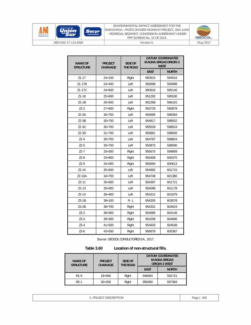
ENVIRONMENTAL IMPACT ASSESSMENT FOR THE RUMICHACA - PASTO DIVIDED HIGHWAY PROJECT, SAN JUAN
- PEDREGAL SEGMENT, CONCESSION AGREEMENT UNDER PPP SCHEME No. 15 OF 2015
GEO-002-17-114-EAM Version 0. May 2017
3. PROJECT DESCRIPTION
Page | 168
NAME OF STRUCTURE
PROJECT CHAINAGE
SIDE OF THE ROAD
DATUM COORDINATES MAGNA SIRGAS ORIGIN 3
WEST
EAST NORTH
Z1-17 24+100 Right 950915 594516
Z1-17B 24+400 Left 950698 594998
Z1-17C 24+600 Left 950916 595145
Z1-18 25+600 Left 951292 595530
Z2-1B 26+500 Left 952268 596191
Z2-2 27+600 Right 953729 595878
Z2-3A 30+700 Left 954695 598394
Z2-3B 30+700 Left 954817 598552
Z2-3C 30+700 Left 955528 598524
Z2-3D 31+700 Left 955861 598500
Z2-4 30+700 Left 954787 598824
Z2-5 30+700 Left 953875 598590
Z2-7 33+300 Right 955670 599909
Z2-8 33+800 Right 955408 600370
Z2-9 34+000 Right 955694 600613
Z2-10 35+600 Left 954992 601715
Z2-10A 34+700 Left 954748 601380
Z2-11 35+600 Left 954397 601721
Z2-13 35+000 Left 954099 601178
Z2-14 36+400 Left 954312 601979
Z3-1B 38+100 R - L 954205 603578
Z3-2B 38+700 Right 954331 604024
Z3-2 38+900 Right 954685 604146
Z3-3 39+300 Right 954208 604696
Z3-4 41+500 Right 954933 604548
Z3-6 43+500 Right 956878 605387
Source: GEOCOL CONSULTORES S.A., 2017.
Table 3.60 Location of non-structural fills.
NAME OF STRUCTURE
PROJECT CHAINAGE
SIDE OF THE ROAD
DATUM COORDINATES MAGNA SIRGAS ORIGIN 3 WEST
EAST NORTH
R1-9 18+940 Right 948404 591721
R2-1 30+200 Right 955450 597384

ENVIRONMENTAL IMPACT ASSESSMENT FOR THE RUMICHACA - PASTO DIVIDED HIGHWAY PROJECT, SAN JUAN
- PEDREGAL SEGMENT, CONCESSION AGREEMENT UNDER PPP SCHEME No. 15 OF 2015
GEO-002-17-114-EAM Version 0. May 2017
3. PROJECT DESCRIPTION
Page | 169
Source: GEOCOL CONSULTORES S.A., 2017.
Figure 3.90 Location of the ZODME and/or Non-Structural fills.
Source: GEOCOL CONSULTORES S.A., 2017.
3.2.5.3 ZODME design.
3.2.5.3.1 Analysis of safety factors and displacement risk.
Based on the results from the field tests and laboratory tests, the geological units were defined for each potential site for the establishment of the Zodme and/or non-structural fills (see Table 3.61).
Table 3.61 Geotechnical units in the assessment area.
GEOTECHNICAL UNIT GEOTECHNICAL CHARACTERIZATION FRICTION ANGLE Ф (°)
COHESION, C (KN/M2)
UNIT WEIGHT, G (KN/M3)
GU I Anthropic fills 30 0 16
GU II Soils with OM And paleosols 28 20 15
GU III Quaternary volcanic ash 30 30 17
GU IVa Loose lithified ash (NSPT <10) 28 25 16
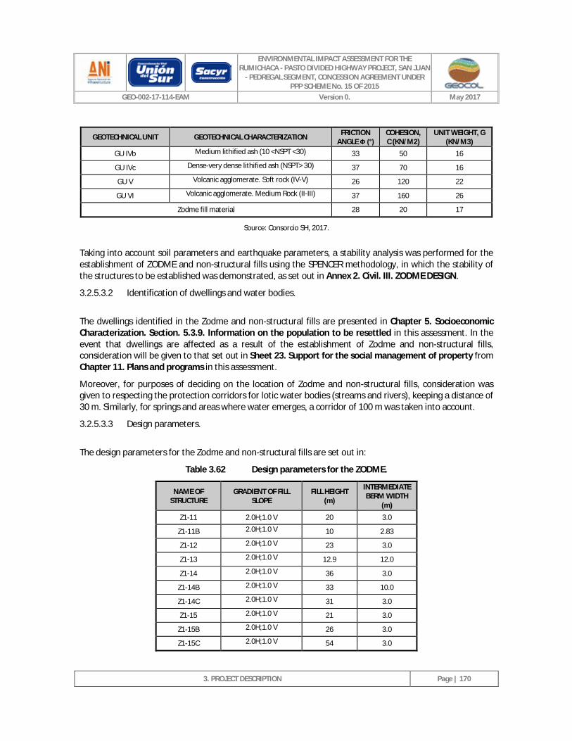
ENVIRONMENTAL IMPACT ASSESSMENT FOR THE RUMICHACA - PASTO DIVIDED HIGHWAY PROJECT, SAN JUAN
- PEDREGAL SEGMENT, CONCESSION AGREEMENT UNDER PPP SCHEME No. 15 OF 2015
GEO-002-17-114-EAM Version 0. May 2017
3. PROJECT DESCRIPTION
Page | 170
GEOTECHNICAL UNIT GEOTECHNICAL CHARACTERIZATION FRICTION ANGLE Ф (°)
COHESION, C (KN/M2)
UNIT WEIGHT, G (KN/M3)
GU IVb Medium lithified ash (10 <NSPT <30) 33 50 16
GU IVc Dense-very dense lithified ash (NSPT> 30) 37 70 16
GU V Volcanic agglomerate. Soft rock (IV-V) 26 120 22
GU VI Volcanic agglomerate. Medium Rock (II-III) 37 160 26
Zodme fill material 28 20 17
Source: Consorcio SH, 2017.
Taking into account soil parameters and earthquake parameters, a stability analysis was performed for the establishment of ZODME and non-structural fills using the SPENCER methodology, in which the stability of the structures to be established was demonstrated, as set out in Annex 2. Civil. III. ZODME DESIGN.
3.2.5.3.2 Identification of dwellings and water bodies.
The dwellings identified in the Zodme and non-structural fills are presented in Chapter 5. Socioeconomic Characterization. Section. 5.3.9. Information on the population to be resettled in this assessment. In the event that dwellings are affected as a result of the establishment of Zodme and non-structural fills, consideration will be given to that set out in Sheet 23. Support for the social management of property from Chapter 11. Plans and programs in this assessment.
Moreover, for purposes of deciding on the location of Zodme and non-structural fills, consideration was given to respecting the protection corridors for lotic water bodies (streams and rivers), keeping a distance of 30 m. Similarly, for springs and areas where water emerges, a corridor of 100 m was taken into account.
3.2.5.3.3 Design parameters.
The design parameters for the Zodme and non-structural fills are set out in:
Table 3.62 Design parameters for the ZODME.
NAME OF STRUCTURE
GRADIENT OF FILL SLOPE
FILL HEIGHT (m)
INTERMEDIATE BERM WIDTH
(m)
Z1-11 2.0H;1.0 V 20 3.0
Z1-11B 2.0H;1.0 V 10 2.83
Z1-12 2.0H;1.0 V 23 3.0
Z1-13 2.0H;1.0 V 12.9 12.0
Z1-14 2.0H;1.0 V 36 3.0
Z1-14B 2.0H;1.0 V 33 10.0
Z1-14C 2.0H;1.0 V 31 3.0
Z1-15 2.0H;1.0 V 21 3.0
Z1-15B 2.0H;1.0 V 26 3.0
Z1-15C 2.0H;1.0 V 54 3.0
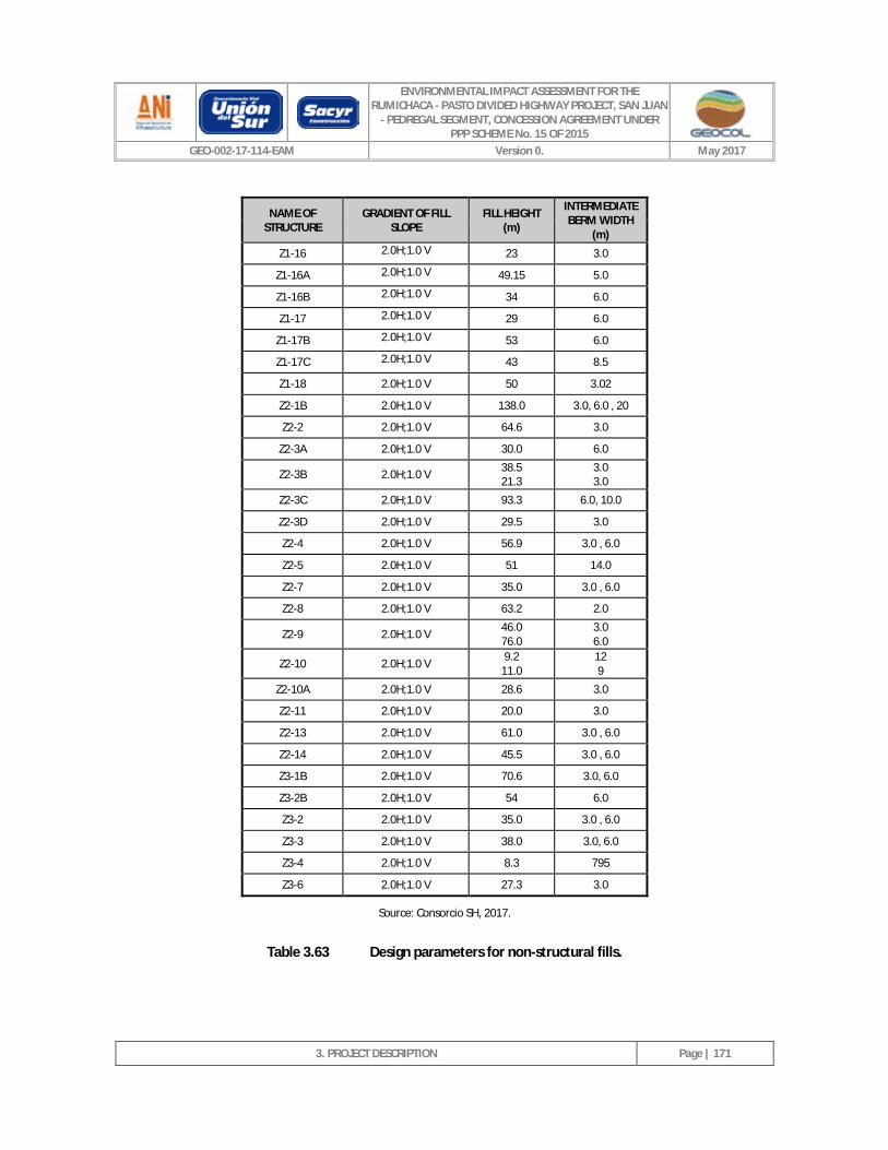
ENVIRONMENTAL IMPACT ASSESSMENT FOR THE RUMICHACA - PASTO DIVIDED HIGHWAY PROJECT, SAN JUAN
- PEDREGAL SEGMENT, CONCESSION AGREEMENT UNDER PPP SCHEME No. 15 OF 2015
GEO-002-17-114-EAM Version 0. May 2017
3. PROJECT DESCRIPTION
Page | 171
NAME OF STRUCTURE
GRADIENT OF FILL SLOPE
FILL HEIGHT (m)
INTERMEDIATE BERM WIDTH
(m)
Z1-16 2.0H;1.0 V 23 3.0
Z1-16A 2.0H;1.0 V 49.15 5.0
Z1-16B 2.0H;1.0 V 34 6.0
Z1-17 2.0H;1.0 V 29 6.0
Z1-17B 2.0H;1.0 V 53 6.0
Z1-17C 2.0H;1.0 V 43 8.5
Z1-18 2.0H;1.0 V 50 3.02
Z2-1B 2.0H;1.0 V 138.0 3.0, 6.0 , 20
Z2-2 2.0H;1.0 V 64.6 3.0
Z2-3A 2.0H;1.0 V 30.0 6.0
Z2-3B 2.0H;1.0 V 38.5 21.3
3.0 3.0
Z2-3C 2.0H;1.0 V 93.3 6.0, 10.0
Z2-3D 2.0H;1.0 V 29.5 3.0
Z2-4 2.0H;1.0 V 56.9 3.0 , 6.0
Z2-5 2.0H;1.0 V 51 14.0
Z2-7 2.0H;1.0 V 35.0 3.0 , 6.0
Z2-8 2.0H;1.0 V 63.2 2.0
Z2-9 2.0H;1.0 V 46.0 76.0
3.0 6.0
Z2-10 2.0H;1.0 V 9.2 11.0
12 9
Z2-10A 2.0H;1.0 V 28.6 3.0
Z2-11 2.0H;1.0 V 20.0 3.0
Z2-13 2.0H;1.0 V 61.0 3.0 , 6.0
Z2-14 2.0H;1.0 V 45.5 3.0 , 6.0
Z3-1B 2.0H;1.0 V 70.6 3.0, 6.0
Z3-2B 2.0H;1.0 V 54 6.0
Z3-2 2.0H;1.0 V 35.0 3.0 , 6.0
Z3-3 2.0H;1.0 V 38.0 3.0, 6.0
Z3-4 2.0H;1.0 V 8.3 795
Z3-6 2.0H;1.0 V 27.3 3.0
Source: Consorcio SH, 2017.
Table 3.63 Design parameters for non-structural fills.
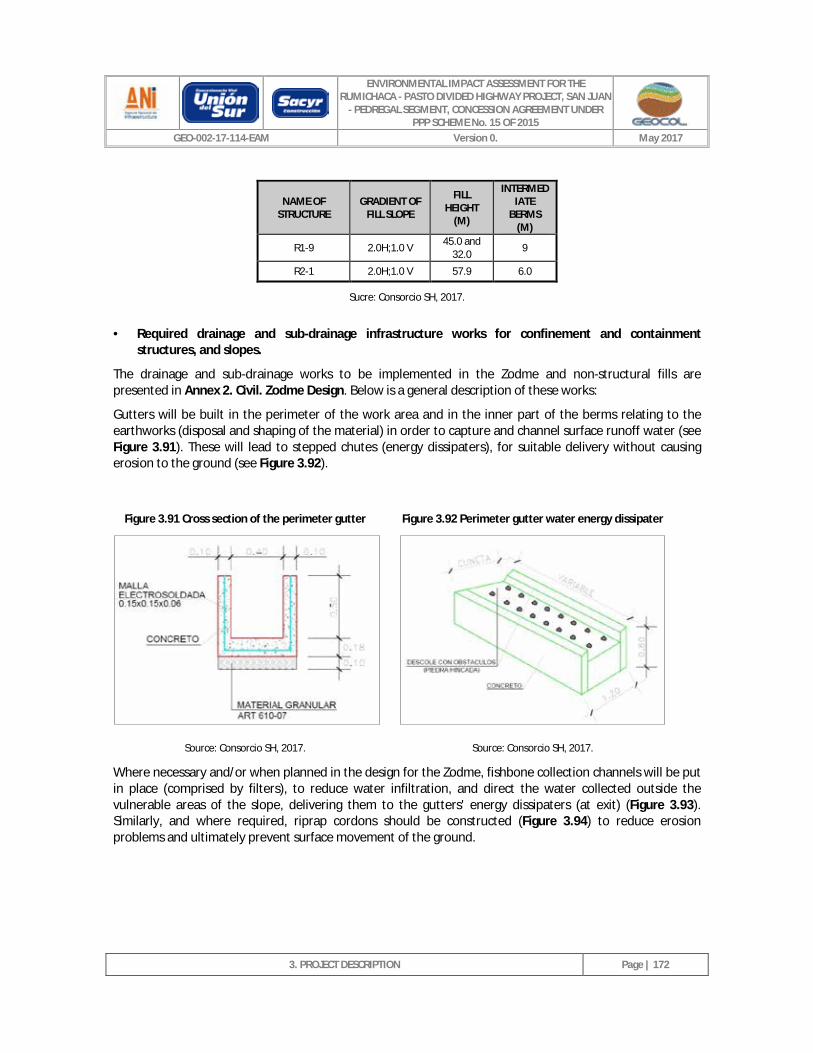
ENVIRONMENTAL IMPACT ASSESSMENT FOR THE RUMICHACA - PASTO DIVIDED HIGHWAY PROJECT, SAN JUAN
- PEDREGAL SEGMENT, CONCESSION AGREEMENT UNDER PPP SCHEME No. 15 OF 2015
GEO-002-17-114-EAM Version 0. May 2017
3. PROJECT DESCRIPTION
Page | 172
NAME OF STRUCTURE
GRADIENT OF FILL SLOPE
FILL HEIGHT
(M)
INTERMEDIATE
BERMS (M)
R1-9 2.0H;1.0 V 45.0 and 32.0 9
R2-1 2.0H;1.0 V 57.9 6.0
Sucre: Consorcio SH, 2017.
· Required drainage and sub-drainage infrastructure works for confinement and containment structures, and slopes.
The drainage and sub-drainage works to be implemented in the Zodme and non-structural fills are presented in Annex 2. Civil. Zodme Design. Below is a general description of these works:
Gutters will be built in the perimeter of the work area and in the inner part of the berms relating to the earthworks (disposal and shaping of the material) in order to capture and channel surface runoff water (see Figure 3.91). These will lead to stepped chutes (energy dissipaters), for suitable delivery without causing erosion to the ground (see Figure 3.92).
Figure 3.91 Cross section of the perimeter gutter Figure 3.92 Perimeter gutter water energy dissipater
Source: Consorcio SH, 2017. Source: Consorcio SH, 2017.
Where necessary and/or when planned in the design for the Zodme, fishbone collection channels will be put in place (comprised by filters), to reduce water infiltration, and direct the water collected outside the vulnerable areas of the slope, delivering them to the gutters' energy dissipaters (at exit) (Figure 3.93). Similarly, and where required, riprap cordons should be constructed (Figure 3.94) to reduce erosion problems and ultimately prevent surface movement of the ground.
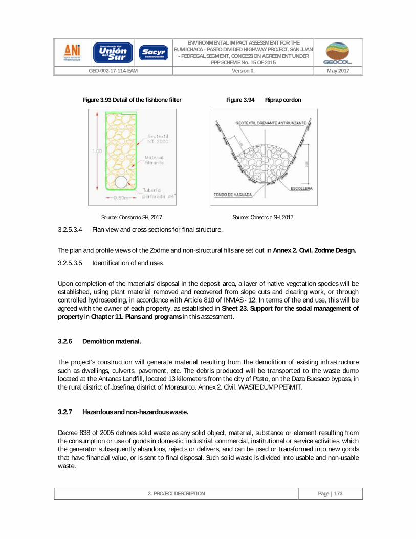
ENVIRONMENTAL IMPACT ASSESSMENT FOR THE RUMICHACA - PASTO DIVIDED HIGHWAY PROJECT, SAN JUAN
- PEDREGAL SEGMENT, CONCESSION AGREEMENT UNDER PPP SCHEME No. 15 OF 2015
GEO-002-17-114-EAM Version 0. May 2017
3. PROJECT DESCRIPTION
Page | 173
Figure 3.93 Detail of the fishbone filter Figure 3.94 Riprap cordon
Source: Consorcio SH, 2017. Source: Consorcio SH, 2017.
3.2.5.3.4 Plan view and cross-sections for final structure.
The plan and profile views of the Zodme and non-structural fills are set out in Annex 2. Civil. Zodme Design.
3.2.5.3.5 Identification of end uses.
Upon completion of the materials' disposal in the deposit area, a layer of native vegetation species will be established, using plant material removed and recovered from slope cuts and clearing work, or through controlled hydroseeding, in accordance with Article 810 of INVIAS - 12. In terms of the end use, this will be agreed with the owner of each property, as established in Sheet 23. Support for the social management of property in Chapter 11. Plans and programs in this assessment.
3.2.6 Demolition material.
The project's construction will generate material resulting from the demolition of existing infrastructure such as dwellings, culverts, pavement, etc. The debris produced will be transported to the waste dump located at the Antanas Landfill, located 13 kilometers from the city of Pasto, on the Daza Buesaco bypass, in the rural district of Josefina, district of Morasurco. Annex 2. Civil. WASTE DUMP PERMIT.
3.2.7 Hazardous and non-hazardous waste.
Decree 838 of 2005 defines solid waste as any solid object, material, substance or element resulting from the consumption or use of goods in domestic, industrial, commercial, institutional or service activities, which the generator subsequently abandons, rejects or delivers, and can be used or transformed into new goods that have financial value, or is sent to final disposal. Such solid waste is divided into usable and non-usable waste.
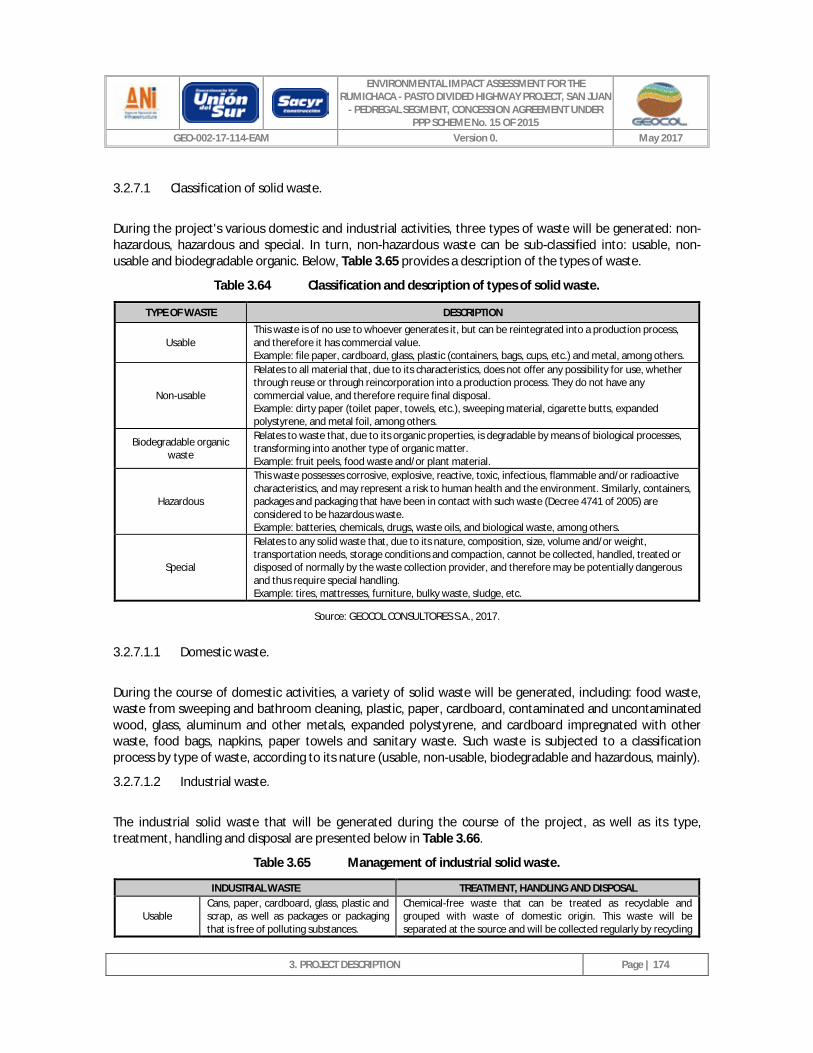
ENVIRONMENTAL IMPACT ASSESSMENT FOR THE RUMICHACA - PASTO DIVIDED HIGHWAY PROJECT, SAN JUAN
- PEDREGAL SEGMENT, CONCESSION AGREEMENT UNDER PPP SCHEME No. 15 OF 2015
GEO-002-17-114-EAM Version 0. May 2017
3. PROJECT DESCRIPTION
Page | 174
3.2.7.1 Classification of solid waste.
During the project's various domestic and industrial activities, three types of waste will be generated: non-hazardous, hazardous and special. In turn, non-hazardous waste can be sub-classified into: usable, non-usable and biodegradable organic. Below, Table 3.65 provides a description of the types of waste.
Table 3.64 Classification and description of types of solid waste.
TYPE OF WASTE DESCRIPTION
Usable This waste is of no use to whoever generates it, but can be reintegrated into a production process, and therefore it has commercial value. Example: file paper, cardboard, glass, plastic (containers, bags, cups, etc.) and metal, among others.
Non-usable
Relates to all material that, due to its characteristics, does not offer any possibility for use, whether through reuse or through reincorporation into a production process. They do not have any commercial value, and therefore require final disposal. Example: dirty paper (toilet paper, towels, etc.), sweeping material, cigarette butts, expanded polystyrene, and metal foil, among others.
Biodegradable organic waste
Relates to waste that, due to its organic properties, is degradable by means of biological processes, transforming into another type of organic matter. Example: fruit peels, food waste and/or plant material.
Hazardous
This waste possesses corrosive, explosive, reactive, toxic, infectious, flammable and/or radioactive characteristics, and may represent a risk to human health and the environment. Similarly, containers, packages and packaging that have been in contact with such waste (Decree 4741 of 2005) are considered to be hazardous waste. Example: batteries, chemicals, drugs, waste oils, and biological waste, among others.
Special
Relates to any solid waste that, due to its nature, composition, size, volume and/or weight, transportation needs, storage conditions and compaction, cannot be collected, handled, treated or disposed of normally by the waste collection provider, and therefore may be potentially dangerous and thus require special handling. Example: tires, mattresses, furniture, bulky waste, sludge, etc.
Source: GEOCOL CONSULTORES S.A., 2017.
3.2.7.1.1 Domestic waste.
During the course of domestic activities, a variety of solid waste will be generated, including: food waste, waste from sweeping and bathroom cleaning, plastic, paper, cardboard, contaminated and uncontaminated wood, glass, aluminum and other metals, expanded polystyrene, and cardboard impregnated with other waste, food bags, napkins, paper towels and sanitary waste. Such waste is subjected to a classification process by type of waste, according to its nature (usable, non-usable, biodegradable and hazardous, mainly).
3.2.7.1.2 Industrial waste.
The industrial solid waste that will be generated during the course of the project, as well as its type, treatment, handling and disposal are presented below in Table 3.66.
Table 3.65 Management of industrial solid waste.
INDUSTRIAL WASTE TREATMENT, HANDLING AND DISPOSAL
Usable Cans, paper, cardboard, glass, plastic and scrap, as well as packages or packaging that is free of polluting substances.
Chemical-free waste that can be treated as recyclable and grouped with waste of domestic origin. This waste will be separated at the source and will be collected regularly by recycling
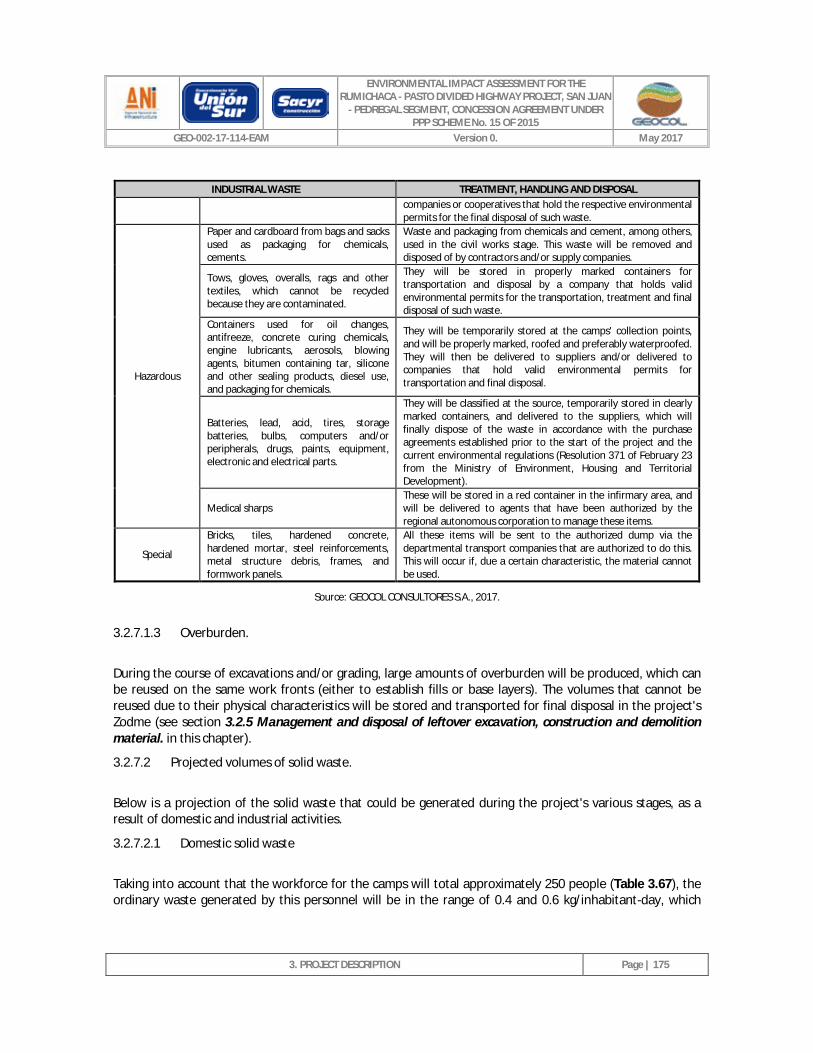
ENVIRONMENTAL IMPACT ASSESSMENT FOR THE RUMICHACA - PASTO DIVIDED HIGHWAY PROJECT, SAN JUAN
- PEDREGAL SEGMENT, CONCESSION AGREEMENT UNDER PPP SCHEME No. 15 OF 2015
GEO-002-17-114-EAM Version 0. May 2017
3. PROJECT DESCRIPTION
Page | 175
INDUSTRIAL WASTE TREATMENT, HANDLING AND DISPOSAL companies or cooperatives that hold the respective environmental permits for the final disposal of such waste.
Hazardous
Paper and cardboard from bags and sacks used as packaging for chemicals, cements.
Waste and packaging from chemicals and cement, among others, used in the civil works stage. This waste will be removed and disposed of by contractors and/or supply companies.
Tows, gloves, overalls, rags and other textiles, which cannot be recycled because they are contaminated.
They will be stored in properly marked containers for transportation and disposal by a company that holds valid environmental permits for the transportation, treatment and final disposal of such waste.
Containers used for oil changes, antifreeze, concrete curing chemicals, engine lubricants, aerosols, blowing agents, bitumen containing tar, silicone and other sealing products, diesel use, and packaging for chemicals.
They will be temporarily stored at the camps' collection points, and will be properly marked, roofed and preferably waterproofed. They will then be delivered to suppliers and/or delivered to companies that hold valid environmental permits for transportation and final disposal.
Batteries, lead, acid, tires, storage batteries, bulbs, computers and/or peripherals, drugs, paints, equipment, electronic and electrical parts.
They will be classified at the source, temporarily stored in clearly marked containers, and delivered to the suppliers, which will finally dispose of the waste in accordance with the purchase agreements established prior to the start of the project and the current environmental regulations (Resolution 371 of February 23 from the Ministry of Environment, Housing and Territorial Development).
Medical sharps These will be stored in a red container in the infirmary area, and will be delivered to agents that have been authorized by the regional autonomous corporation to manage these items.
Special
Bricks, tiles, hardened concrete, hardened mortar, steel reinforcements, metal structure debris, frames, and formwork panels.
All these items will be sent to the authorized dump via the departmental transport companies that are authorized to do this. This will occur if, due a certain characteristic, the material cannot be used.
Source: GEOCOL CONSULTORES S.A., 2017.
3.2.7.1.3 Overburden.
During the course of excavations and/or grading, large amounts of overburden will be produced, which can be reused on the same work fronts (either to establish fills or base layers). The volumes that cannot be reused due to their physical characteristics will be stored and transported for final disposal in the project's Zodme (see section 3.2.5 Management and disposal of leftover excavation, construction and demolition material. in this chapter).
3.2.7.2 Projected volumes of solid waste.
Below is a projection of the solid waste that could be generated during the project's various stages, as a result of domestic and industrial activities.
3.2.7.2.1 Domestic solid waste
Taking into account that the workforce for the camps will total approximately 250 people (Table 3.67), the ordinary waste generated by this personnel will be in the range of 0.4 and 0.6 kg/inhabitant-day, which
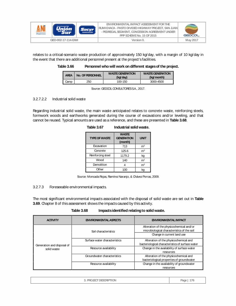
ENVIRONMENTAL IMPACT ASSESSMENT FOR THE RUMICHACA - PASTO DIVIDED HIGHWAY PROJECT, SAN JUAN
- PEDREGAL SEGMENT, CONCESSION AGREEMENT UNDER PPP SCHEME No. 15 OF 2015
GEO-002-17-114-EAM Version 0. May 2017
3. PROJECT DESCRIPTION
Page | 176
relates to a critical-scenario waste production of approximately 150 kg/day, with a margin of 10 kg/day in the event that there are additional personnel present at the project's facilities.
Table 3.66 Personnel who will work on different stages of the project.
AREA No. OF PERSONNEL WASTE GENERATION (kg/day)
WASTE GENERATION (kg/month)
Camp 250 100-150 3000-4500
Source: GEOCOL CONSULTORES S.A., 2017.
3.2.7.2.2 Industrial solid waste
Regarding industrial solid waste, the main waste anticipated relates to concrete waste, reinforcing steels, formwork woods and earthworks generated during the course of excavations and/or leveling, and that cannot be reused. Typical amounts are used as a reference, and these are presented in Table 3.68.
Table 3.67 Industrial solid waste.
TYPE OF WASTE WASTE
GENERATION (month)
UNIT
Excavation 713 m3 Concrete 125.6 m3
Reinforcing steel 1179.2 kg Wood 140 m2
Demolition 4 m3 Other 100 kg
Source: Moncada Rojas, Ramírez Naranjo, & Chávez Porras, 2009.
3.2.7.3 Foreseeable environmental impacts.
The most significant environmental impacts associated with the disposal of solid waste are set out in Table 3.69. Chapter 8 of this assessment shows the impacts caused by this activity.
Table 3.68 Impacts identified relating to solid waste.
ACTIVITY ENVIRONMENTAL ASPECTS ENVIRONMENTAL IMPACT
Generation and disposal of solid waste
Soil characteristics Alteration of the physicochemical and/or microbiological characteristics of the soil
Change in current land use
Surface water characteristics Alteration of the physicochemical and bacteriological characteristics of surface water
Resource availability Change in the availability of surface water resources
Groundwater characteristics Alteration of the physicochemical and bacteriological properties of groundwater
Resource availability Change in the availability of groundwater resources
ENVIRONMENTAL IMPACT ASSESSMENT FOR THE RUMICHACA - PASTO DIVIDED HIGHWAY PROJECT, SAN JUAN
- PEDREGAL SEGMENT, CONCESSION AGREEMENT UNDER PPP SCHEME No. 15 OF 2015
GEO-002-17-114-EAM Version 0. May 2017
3. PROJECT DESCRIPTION
Page | 177
Air quality Change in gas concentration
Source: GEOCOL CONSULTORES S.A., 2017.
The impacts generated by solid waste can basically arise due to the degradation of organic matter, as this leads to the generation of leachates that can affect the soil as a result of infiltration. Moreover, gases can also be produced -also arising from the decomposition process-, such as methane and carbon dioxide, which are considered to be greenhouse gases. The following is an overview of the waste’s treatment, management and disposal.
3.2.7.4 Management and disposal.
The following should be carried out prior to commencing activities:
o Identification of the waste that will be generated during the activities to be carried out.
o Identification of generation points.
o Procedure for classification and separation at the source.
o Procedure for the collection of waste in work fronts and temporary sites.
o Procedure for separation, quantification and storage at temporary storage sites.
o Establishment of collection periods and final waste disposal, in accordance with the type of waste generated.
As a strategy for the management and final disposal of solid waste, the plan is to deliver such waste to an authorized agent, which will be responsible for its collection, transportation, treatment and final disposal and/or delivery to legally established municipal utilities that have a landfill possessing a valid environmental license.
3.2.7.4.1 Identification and classification of waste.
We will encourage the minimization of waste at generation points, with priority being given to minimization at the source (reduce, recycle and reuse, harnessing the materials and/or energy contained in the waste). To this end, the following activities should be considered for the minimization of potential impacts from waste generation:
o Classification at the source: the waste must be separated in the work front, in accordance with its origin and nature.
o Reuse: where possible, waste such as paper, cardboard, containers, packaging, structures, cables and insulators etc. should be reused.
o Recycling: solid waste that can be reused as a raw material for the production of new items should be separated.
o Final disposal: after being classified and packed, the waste must be delivered to an authorized agent and disposed of in sites authorized for this purpose.
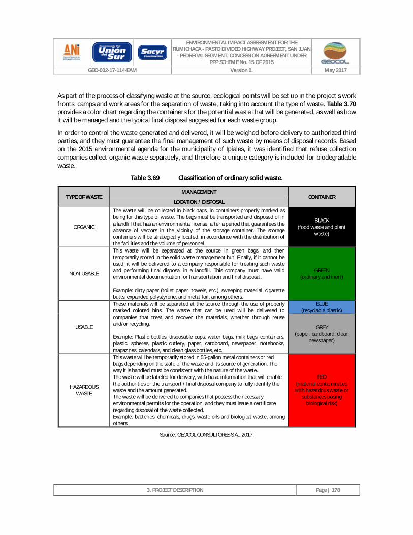
ENVIRONMENTAL IMPACT ASSESSMENT FOR THE RUMICHACA - PASTO DIVIDED HIGHWAY PROJECT, SAN JUAN
- PEDREGAL SEGMENT, CONCESSION AGREEMENT UNDER PPP SCHEME No. 15 OF 2015
GEO-002-17-114-EAM Version 0. May 2017
3. PROJECT DESCRIPTION
Page | 178
As part of the process of classifying waste at the source, ecological points will be set up in the project's work fronts, camps and work areas for the separation of waste, taking into account the type of waste. Table 3.70 provides a color chart regarding the containers for the potential waste that will be generated, as well as how it will be managed and the typical final disposal suggested for each waste group.
In order to control the waste generated and delivered, it will be weighed before delivery to authorized third parties, and they must guarantee the final management of such waste by means of disposal records. Based on the 2015 environmental agenda for the municipality of Ipiales, it was identified that refuse collection companies collect organic waste separately, and therefore a unique category is included for biodegradable waste.
Table 3.69 Classification of ordinary solid waste.
TYPE OF WASTE MANAGEMENT
CONTAINER LOCATION / DISPOSAL
ORGANIC
The waste will be collected in black bags, in containers properly marked as being for this type of waste. The bags must be transported and disposed of in a landfill that has an environmental license, after a period that guarantees the absence of vectors in the vicinity of the storage container. The storage containers will be strategically located, in accordance with the distribution of the facilities and the volume of personnel.
BLACK (food waste and plant
waste)
NON-USABLE
This waste will be separated at the source in green bags, and then temporarily stored in the solid waste management hut. Finally, if it cannot be used, it will be delivered to a company responsible for treating such waste and performing final disposal in a landfill. This company must have valid environmental documentation for transportation and final disposal. Example: dirty paper (toilet paper, towels, etc.), sweeping material, cigarette butts, expanded polystyrene, and metal foil, among others.
GREEN (ordinary and inert)
USABLE
These materials will be separated at the source through the use of properly marked colored bins. The waste that can be used will be delivered to companies that treat and recover the materials, whether through reuse and/or recycling. Example: Plastic bottles, disposable cups, water bags, milk bags, containers, plastic, spheres, plastic cutlery, paper, cardboard, newspaper, notebooks, magazines, calendars, and clean glass bottles, etc.
BLUE (recyclable plastic)
GREY (paper, cardboard, clean
newspaper)
HAZARDOUS WASTE
This waste will be temporarily stored in 55-gallon metal containers or red bags depending on the state of the waste and its source of generation. The way it is handled must be consistent with the nature of the waste. The waste will be labeled for delivery, with basic information that will enable the authorities or the transport / final disposal company to fully identify the waste and the amount generated. The waste will be delivered to companies that possess the necessary environmental permits for the operation, and they must issue a certificate regarding disposal of the waste collected. Example: batteries, chemicals, drugs, waste oils and biological waste, among others.
RED (material contaminated with hazardous waste or
substances posing biological risk)
Source: GEOCOL CONSULTORES S.A., 2017.
ENVIRONMENTAL IMPACT ASSESSMENT FOR THE RUMICHACA - PASTO DIVIDED HIGHWAY PROJECT, SAN JUAN
- PEDREGAL SEGMENT, CONCESSION AGREEMENT UNDER PPP SCHEME No. 15 OF 2015
GEO-002-17-114-EAM Version 0. May 2017
3. PROJECT DESCRIPTION
Page | 179
3.2.7.4.2 Temporary storage of waste.
During the generation of solid waste, a collection center will be required for the temporary storage of such waste, until it is delivered to a third party for treatment, use and/or final disposal. The following should be considered for implementation of the collection center:
o The collection center must be protected from the weather and potential vectors, and it should only be accessed by personnel authorized for waste storage or disposal.
o It must have an impermeable surface made of cement or geomembrane.
o For safety, hazardous waste should be kept isolated from non-hazardous waste by means of a compartment. This is in order to avoid contamination.
o The collection center should have good ventilation as a safety measure, and as a means of controlling potential odors.
o The collection center should be located far away from canteens or camps, and should take into account the direction of the wind.
o A fire-fighting system should be implemented as a precautionary measure, in addition to wash units in the event of contact with hazardous waste, and personal protective equipment.
o Proper signage must be put in place, and in the case of hazardous waste, the respective identification regarding the waste's nature must be provided.
The collection center must comply with all other provisions established by Decree 2981 of 2013.
Special waste of a high volume must be disposed of in areas suitable for this purpose. In case of material such as scrap, the area must be conditioned to avoid exposure to the weather and avoid the corrosion-related leaching of secondary waste.
The waste storage period must be such that it ensures that the collection center's capacity does not exceed 90% of its total capacity, and this also depends on the conditions relating to the waste stored. For example, it should be ensured that biodegradable waste is delivered at certain intervals in order to avoid the occurrence of odors, vectors and leaching.
3.2.7.4.3 Collection and transport.
The collection routes will be implemented and adjusted in accordance with the volumes and characteristics of the waste, with a view to carrying out ongoing collection that prioritizes waste that, due to its characteristics, needs to be transported and disposed of within a shorter period of time.
Waste that requires special handling, such as hazardous waste and certain special waste, must be delivered to third parties that hold the respective permits for treatment and final disposal.
The following minimum precautions must be taken during the collection and transportation process:
o The load in the vehicle must be properly accommodated, stowed, stacked, secured and covered, in such a way as not to pose danger to persons or the environment.
o The transporter must have basic emergency response items, such as: a fire extinguisher, protective clothing, flashlight, first aid kit, collection and cleaning equipment.
ENVIRONMENTAL IMPACT ASSESSMENT FOR THE RUMICHACA - PASTO DIVIDED HIGHWAY PROJECT, SAN JUAN
- PEDREGAL SEGMENT, CONCESSION AGREEMENT UNDER PPP SCHEME No. 15 OF 2015
GEO-002-17-114-EAM Version 0. May 2017
3. PROJECT DESCRIPTION
Page | 180
o The waste transporter must have a contingency plan, since in the event of a spill or leak of hazardous waste during transportation, they must adopt the necessary contingency measures to protect human health and the environment.
o Those providing the collection, utilization, treatment and final disposal service must certify the weight of the waste delivered by the company, while the company will also keep a regular record of the weight generated, by type of waste.
o The collection and transportation of waste must comply with the requirements established in Decrees 2981 of 2013, 1609 of 2002, and 4741 of 2005.
3.2.7.4.4 Final disposal
The final disposal of waste will be in accordance with its nature as non-usable, usable or hazardous.
With regard to ordinary non-usable waste, it will be disposed of in a landfill that possesses an environmental license and/or it will be delivered to companies authorized for its transportation and final disposal.
Usable solid waste will be delivered to recycling companies for reuse or re-inclusion in the life cycle.
Hazardous waste will be delivered to companies responsible for its treatment and disposal, and that have the respective environmental permits to carry out this type of activity.
Special industrial solid waste must be delivered to companies authorized for its collection, treatment and final disposal.
3.2.8 Project costs.
The implementation of the activities relating to the Rumichaca - Pasto Divided Highway Project, San Juan - Pedregal Segment, will have an estimated average cost of seven hundred seventy eight billion two hundred and twenty three million seven hundred and thirteen thousand one hundred six ($778,223,713,106) Colombian pesos.
3.2.9 Project schedule.
The Rumichaca - Pasto Divided Highway Project, San Juan - Pedregal Segment, will last for 1,264 days according to the scheduling for the implementation of works, as set out in Annex 2. Civil. XII. Schedule and Organizational Chart (See Figure 3.95).
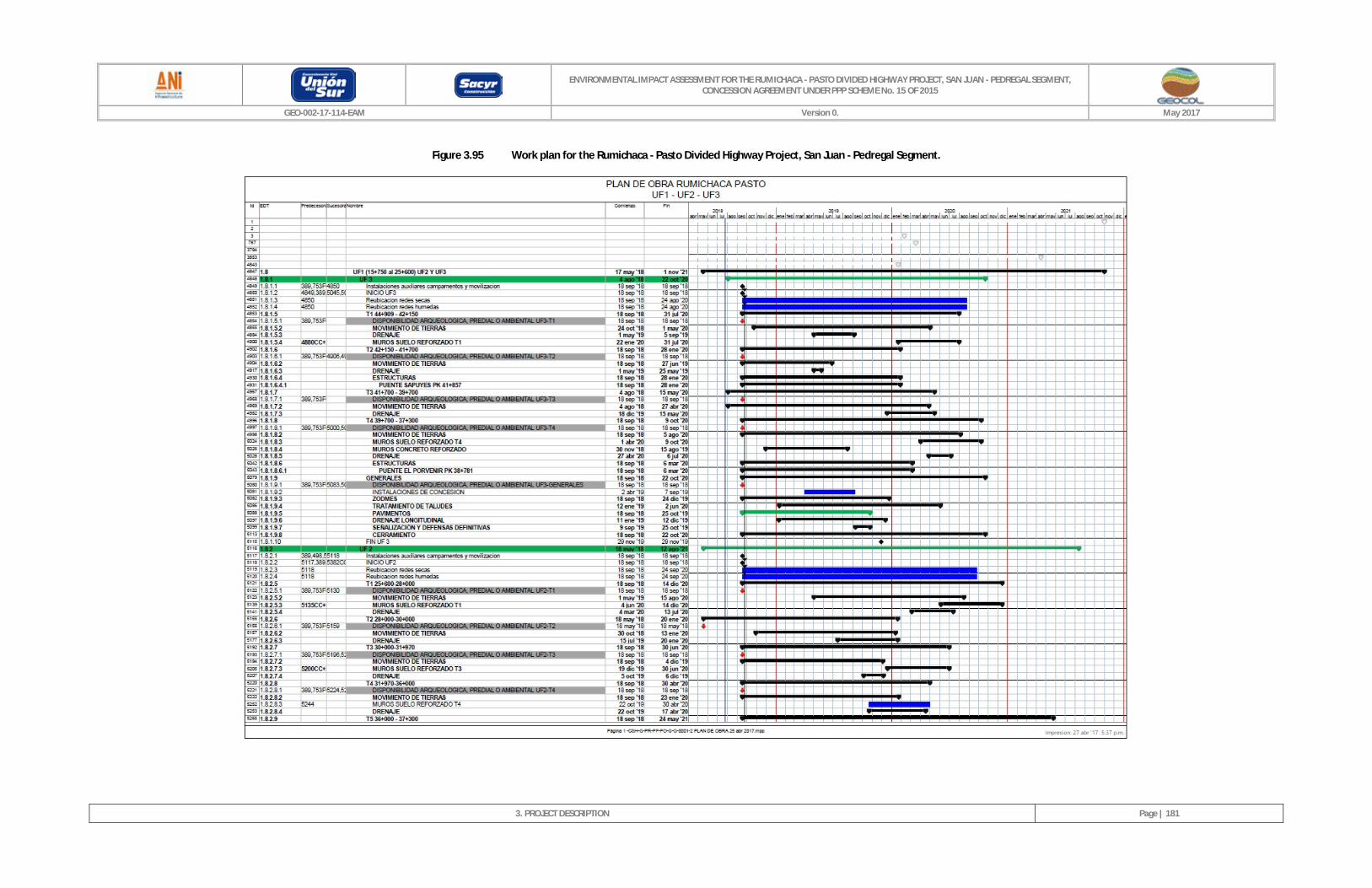
ENVIRONMENTAL IMPACT ASSESSMENT FOR THE RUMICHACA - PASTO DIVIDED HIGHWAY PROJECT, SAN JUAN - PEDREGAL SEGMENT, CONCESSION AGREEMENT UNDER PPP SCHEME No. 15 OF 2015
GEO-002-17-114-EAM Version 0. May 2017
3. PROJECT DESCRIPTION
Page | 181
Figure 3.95 Work plan for the Rumichaca - Pasto Divided Highway Project, San Juan - Pedregal Segment.
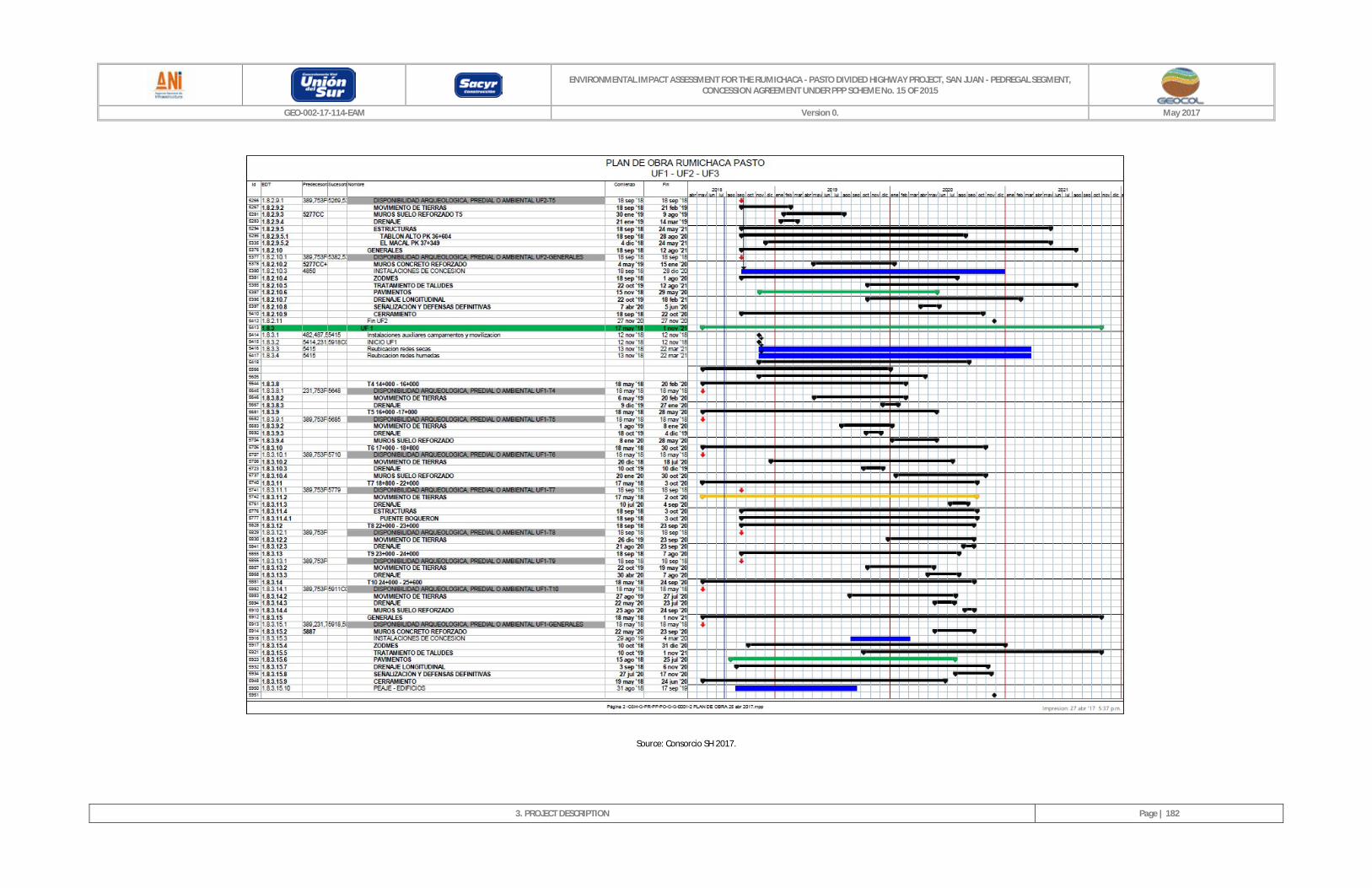
ENVIRONMENTAL IMPACT ASSESSMENT FOR THE RUMICHACA - PASTO DIVIDED HIGHWAY PROJECT, SAN JUAN - PEDREGAL SEGMENT, CONCESSION AGREEMENT UNDER PPP SCHEME No. 15 OF 2015
GEO-002-17-114-EAM Version 0. May 2017
3. PROJECT DESCRIPTION
Page | 182
Source: Consorcio SH 2017.
ENVIRONMENTAL IMPACT ASSESSMENT FOR THE RUMICHACA - PASTO DIVIDED HIGHWAY PROJECT, SAN JUAN
- PEDREGAL SEGMENT, CONCESSION AGREEMENT UNDER PPP SCHEME No. 15 OF 2015
GEO-002-17-114-EAM Version 0. May 2017
3. PROJECT DESCRIPTION
Page | 183
3.2.10 Project organization.
The organizational chart presented in Annex 2. Civil. XII. Schedule and Organizational Chart (see Figure 3.96) will be in place for implementation of the Rumichaca - Pasto Divided Highway Project, San Juan - Pedregal Segment.
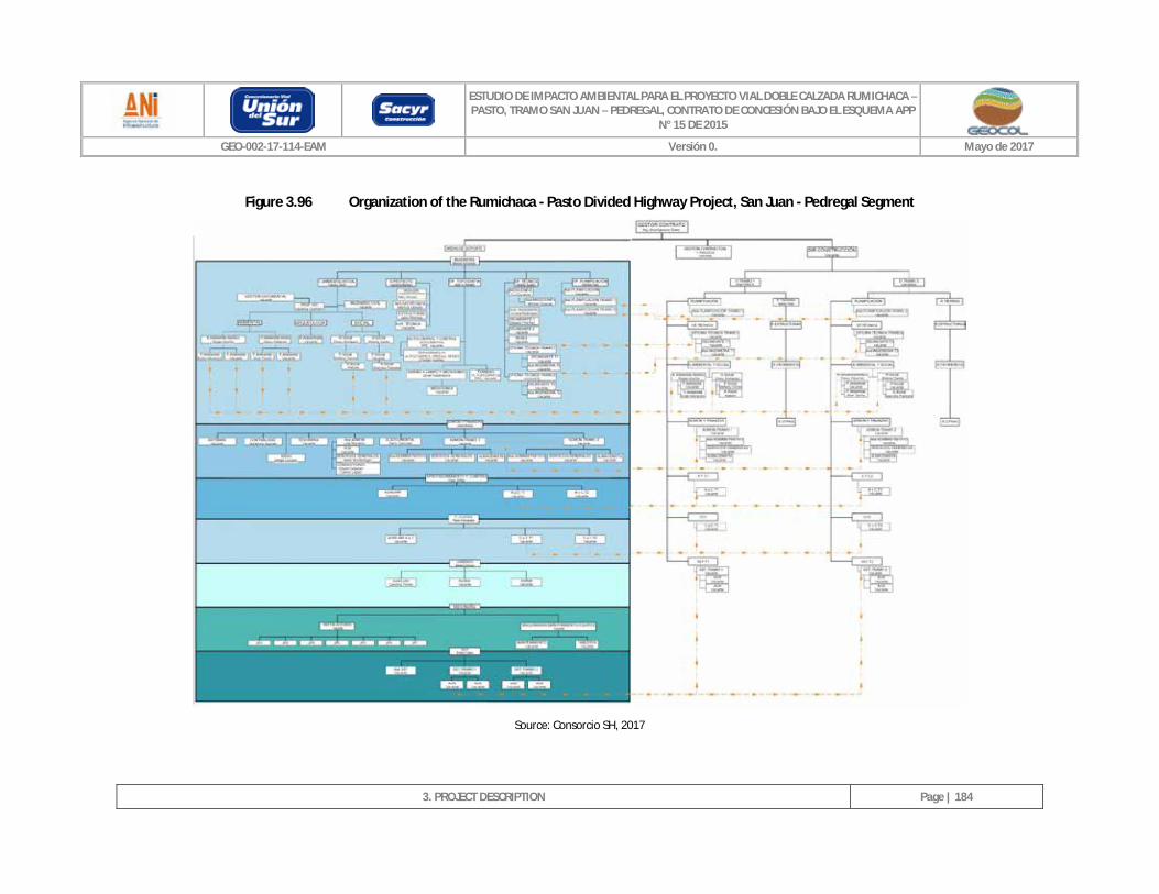
ESTUDIO DE IMPACTO AMBIENTAL PARA EL PROYECTO VIAL DOBLE CALZADA RUMICHACA – PASTO, TRAMO SAN JUAN – PEDREGAL, CONTRATO DE CONCESIÓN BAJO EL ESQUEMA APP
N° 15 DE 2015
GEO-002-17-114-EAM Versión 0. Mayo de 2017
3. PROJECT DESCRIPTION
Page | 184
Figure 3.96 Organization of the Rumichaca - Pasto Divided Highway Project, San Juan - Pedregal Segment
Source: Consorcio SH, 2017


![GrapeCity Telemarketing functional presentation [PPS:3.58 MB]](https://img.pdfslide.us/doc/110x75/54bfdee44a7959976a8b457e/grapecity-telemarketing-functional-presentation-pps358-mb.jpg)