Embed Size (px)
Citation preview

Contents
Foreword
I. Introduction
II. Public Views Collected in the Stage 1 Public Engagement
III. The Refined Urban Design Framework A. Responding to Public Aspirations B. Urban Design Vision and Objectives C. The Refined Urban Design Framework D. Urban Design Emphases 1. Diversity and Vibrancy 2. Development Intensity in Harmony with the Harbourfront 3. Respecting the Natural Context and Existing Urban Fabric 4. Ease of Access and Pedestrian Connectivity 5. Respecting Cultural Heritage 6. Promoting Environmentally Friendly Design and Greening IV. Design Concepts for Key Sites A. Pierside Corridor (Sites 1 and 2) B. Statue Square Corridor (Site 3) C. Site North of City Hall (Site 4) D. Arts and Cultural Precinct (Sites 5 and 6) E. Waterfront Promenade (Site 7) F. Site near Central Piers No. 9 and 10 (Site 8) G. Re-assembling Queen’s Pier and Reconstructing the Old Star Ferry Clock Tower
V. Illustrative Master Layout Plans
VI. A Balanced and Sustainable Approach
VII. Public Views Sought
Co
nten
ts
Forew
ord
01
Foreword
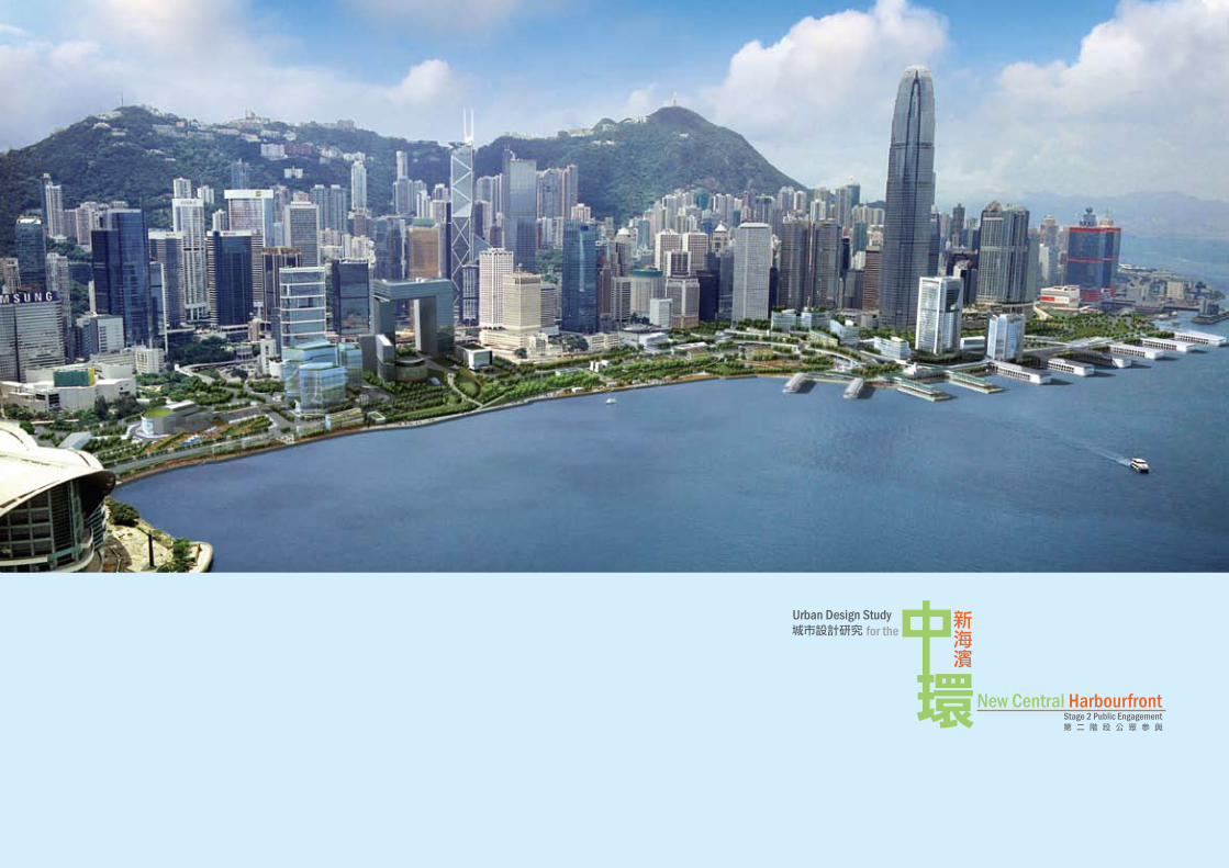
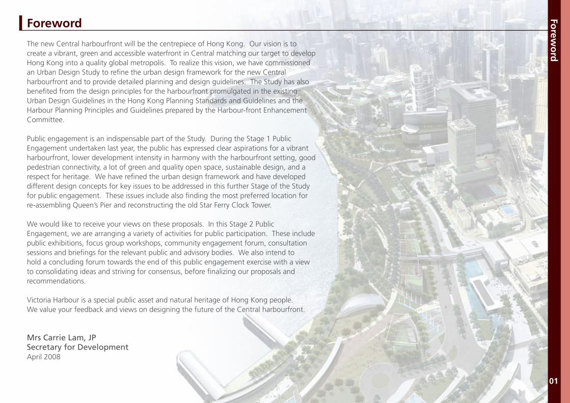
The new Central harbourfront will be the centrepiece of Hong Kong. Our vision is to create a vibrant, green and accessible waterfront in Central matching our target to develop Hong Kong into a quality global metropolis. To realize this vision, we have commissioned an Urban Design Study to refine the urban design framework for the new Central harbourfront and to provide detailed planning and design guidelines. The Study has also benefited from the design principles for the harbourfront promulgated in the existing Urban Design Guidelines in the Hong Kong Planning Standards and Guidelines and the Harbour Planning Principles and Guidelines prepared by the Harbour-front Enhancement Committee.
Public engagement is an indispensable part of the Study. During the Stage 1 Public Engagement undertaken last year, the public has expressed clear aspirations for a vibrant harbourfront, lower development intensity in harmony with the harbourfront setting, good pedestrian connectivity, a lot of green and quality open space, sustainable design, and a respect for heritage. We have refined the urban design framework and have developed different design concepts for key issues to be addressed in this further Stage of the Study for public engagement. These issues include also finding the most preferred location for re-assembling Queen’s Pier and reconstructing the old Star Ferry Clock Tower.
We would like to receive your views on these proposals. In this Stage 2 Public Engagement, we are arranging a variety of activities for public participation. These include public exhibitions, focus group workshops, community engagement forum, consultation sessions and briefings for the relevant public and advisory bodies. We also intend to hold a concluding forum towards the end of this public engagement exercise with a view to consolidating ideas and striving for consensus, before finalizing our proposals and recommendations.
Victoria Harbour is a special public asset and natural heritage of Hong Kong people. We value your feedback and views on designing the future of the Central harbourfront.
Mrs Carrie Lam, JPSecretary for DevelopmentApril 2008
I. Introduction
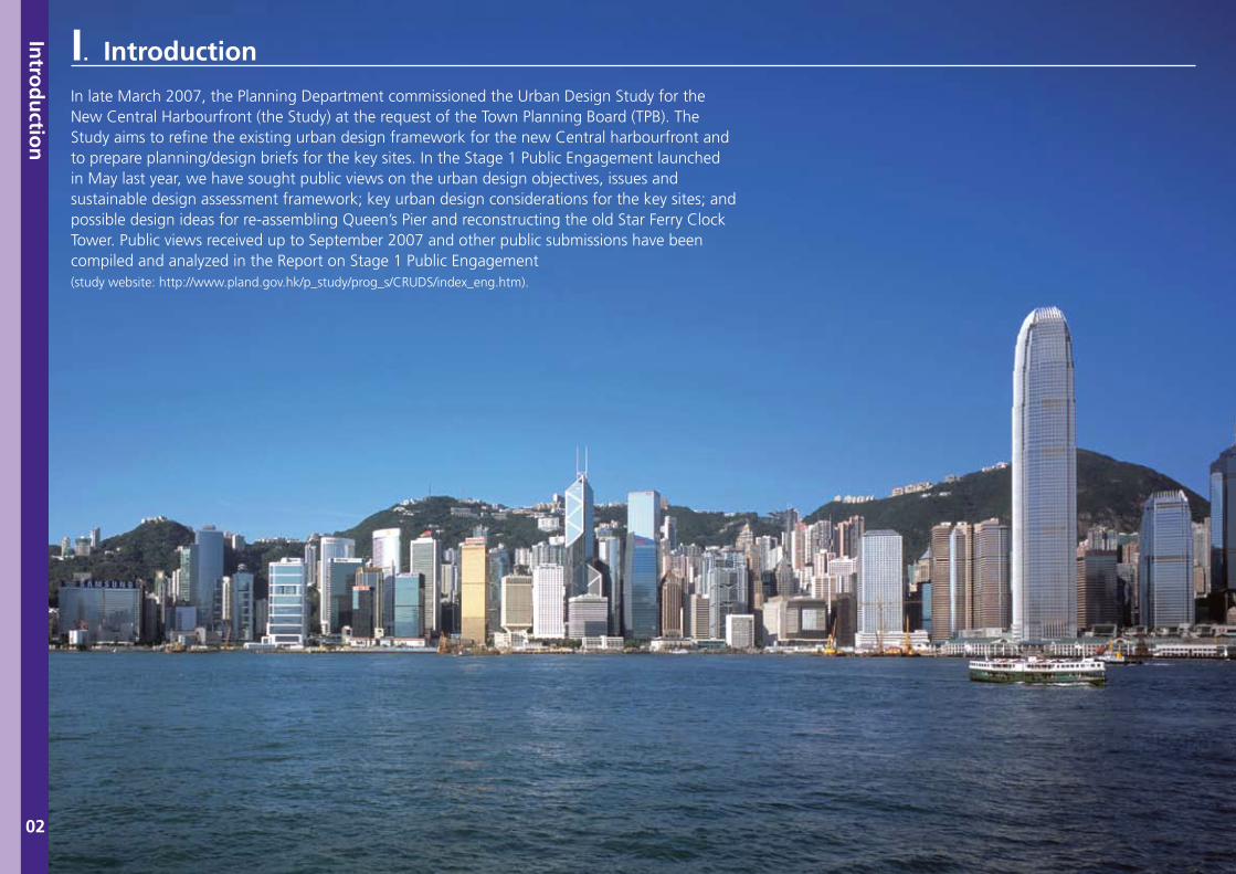
In late March 2007, the Planning Department commissioned the Urban Design Study for the New Central Harbourfront (the Study) at the request of the Town Planning Board (TPB). The Study aims to refine the existing urban design framework for the new Central harbourfront and to prepare planning/design briefs for the key sites. In the Stage 1 Public Engagement launched in May last year, we have sought public views on the urban design objectives, issues and sustainable design assessment framework; key urban design considerations for the key sites; and possible design ideas for re-assembling Queen’s Pier and reconstructing the old Star Ferry Clock Tower. Public views received up to September 2007 and other public submissions have been compiled and analyzed in the Report on Stage 1 Public Engagement(study website: http://www.pland.gov.hk/p_study/prog_s/CRUDS/index_eng.htm).
Intro
du
ction
02
Intro
du
ction
03
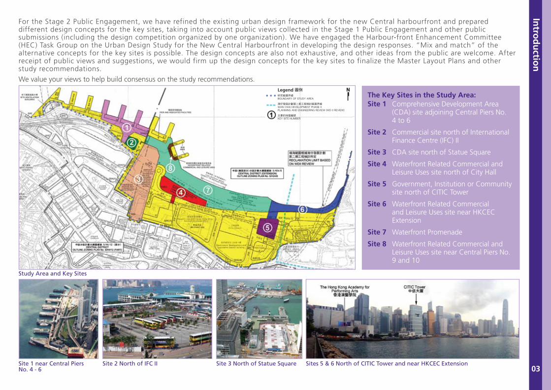
For the Stage 2 Public Engagement, we have refined the existing urban design framework for the new Central harbourfront and prepared different design concepts for the key sites, taking into account public views collected in the Stage 1 Public Engagement and other public submissions (including the design competition organized by one organization). We have engaged the Harbour-front Enhancement Committee (HEC) Task Group on the Urban Design Study for the New Central Harbourfront in developing the design responses. “Mix and match” of the alternative concepts for the key sites is possible. The design concepts are also not exhaustive, and other ideas from the public are welcome. After receipt of public views and suggestions, we would firm up the design concepts for the key sites to finalize the Master Layout Plans and other study recommendations.
We value your views to help build consensus on the study recommendations.
Comprehensive Development Area (CDA) site adjoining Central Piers No. 4 to 6
Commercial site north of International Finance Centre (IFC) II
CDA site north of Statue Square
Waterfront Related Commercial and Leisure Uses site north of City Hall
Government, Institution or Community site north of CITIC Tower
Waterfront Related Commercial and Leisure Uses site near HKCEC Extension
Waterfront Promenade
Waterfront Related Commercial and Leisure Uses site near Central Piers No. 9 and 10
Site 1
Site 2
Site 3
Site 4
Site 5
Site 6
Site 7
Site 8
Study Area and Key Sites
Site 1 near Central PiersNo. 4 - 6
Site 2 North of IFC II Site 3 North of Statue Square Sites 5 & 6 North of CITIC Tower and near HKCEC Extension
The Key Sites in the Study Area:
II. Public Views Collected in the Stage 1 Public Engagement
Pub
lic View
s Co
llected in
the Stag
e 1 Pub
lic Eng
agem
ent
04 Stage I Public Engagement
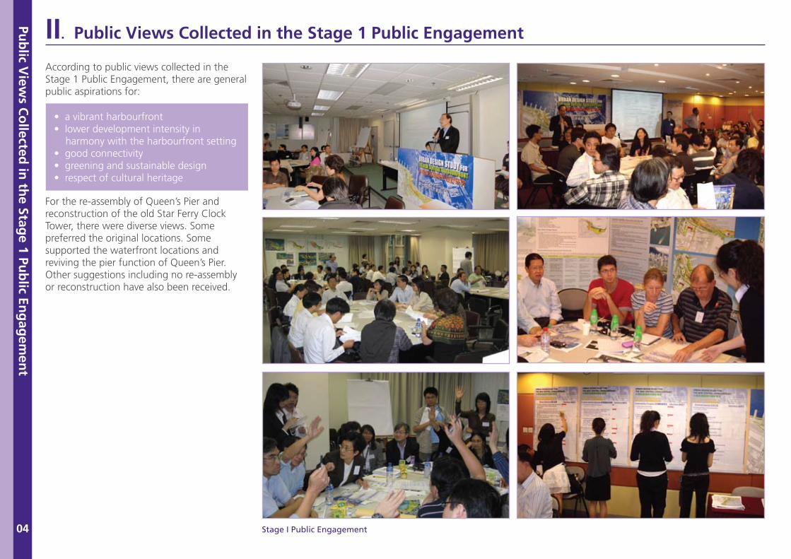
According to public views collected in the Stage 1 Public Engagement, there are general public aspirations for:
For the re-assembly of Queen’s Pier and reconstruction of the old Star Ferry Clock Tower, there were diverse views. Some preferred the original locations. Some supported the waterfront locations and reviving the pier function of Queen’s Pier. Other suggestions including no re-assembly or reconstruction have also been received.
• a vibrant harbourfront• lower development intensity in harmony with the harbourfront setting• good connectivity• greening and sustainable design• respect of cultural heritage
The R
efin
ed U
rban
Desig
n Fram
ewo
rk
05
III. The Refined Urban Design Framework
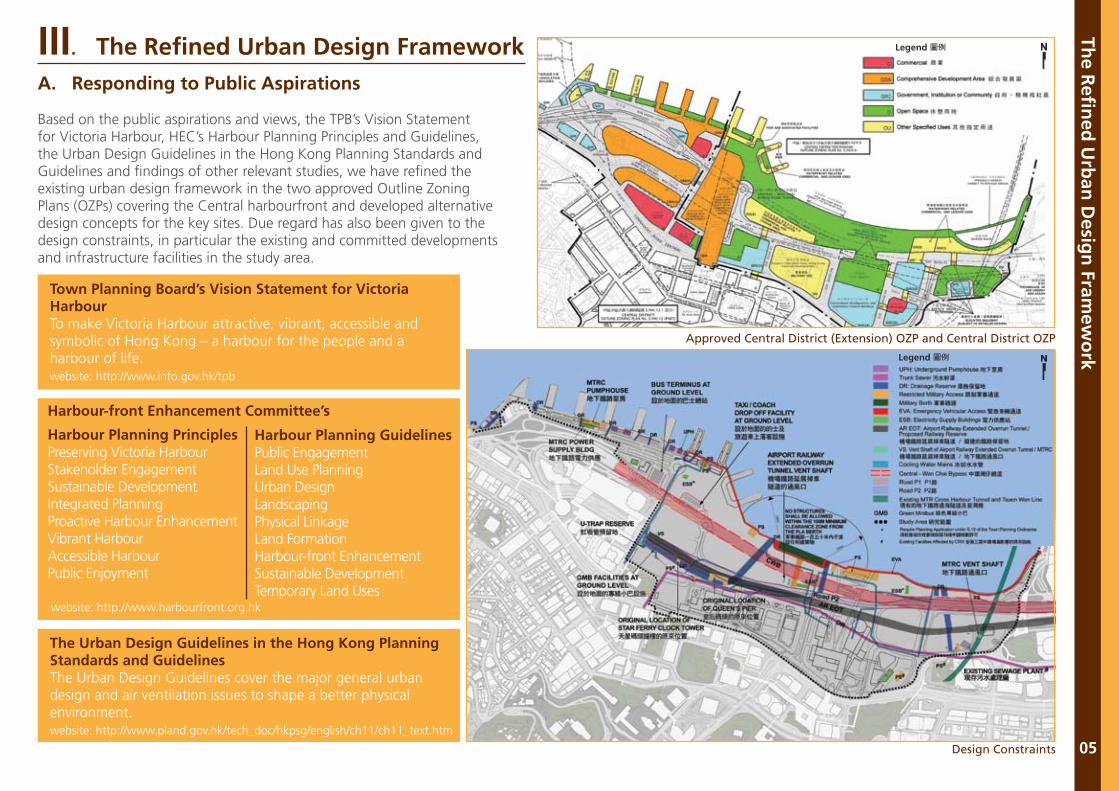
Town Planning Board’s Vision Statement for Victoria HarbourTo make Victoria Harbour attractive, vibrant, accessible and symbolic of Hong Kong – a harbour for the people and a harbour of life.website: http://www.info.gov.hk/tpb
The Urban Design Guidelines in the Hong Kong Planning Standards and GuidelinesThe Urban Design Guidelines cover the major general urban design and air ventilation issues to shape a better physical environment.website: http://www.pland.gov.hk/tech_doc/hkpsg/english/ch11/ch11_text.htm
website: http://www.harbourfront.org.hk
Approved Central District (Extension) OZP and Central District OZP
Design Constraints
Harbour-front Enhancement Committee’s
Harbour Planning PrinciplesPreserving Victoria HarbourStakeholder EngagementSustainable DevelopmentIntegrated PlanningProactive Harbour EnhancementVibrant HarbourAccessible HarbourPublic Enjoyment
Harbour Planning GuidelinesPublic EngagementLand Use PlanningUrban DesignLandscapingPhysical LinkageLand FormationHarbour-front EnhancementSustainable DevelopmentTemporary Land Uses
A. Responding to Public Aspirations
Based on the public aspirations and views, the TPB’s Vision Statement for Victoria Harbour, HEC’s Harbour Planning Principles and Guidelines, the Urban Design Guidelines in the Hong Kong Planning Standards and Guidelines and findings of other relevant studies, we have refined the existing urban design framework in the two approved Outline Zoning Plans (OZPs) covering the Central harbourfront and developed alternative design concepts for the key sites. Due regard has also been given to the design constraints, in particular the existing and committed developments and infrastructure facilities in the study area.
The R
efin
ed U
rban
Desig
n Fram
ewo
rk
06
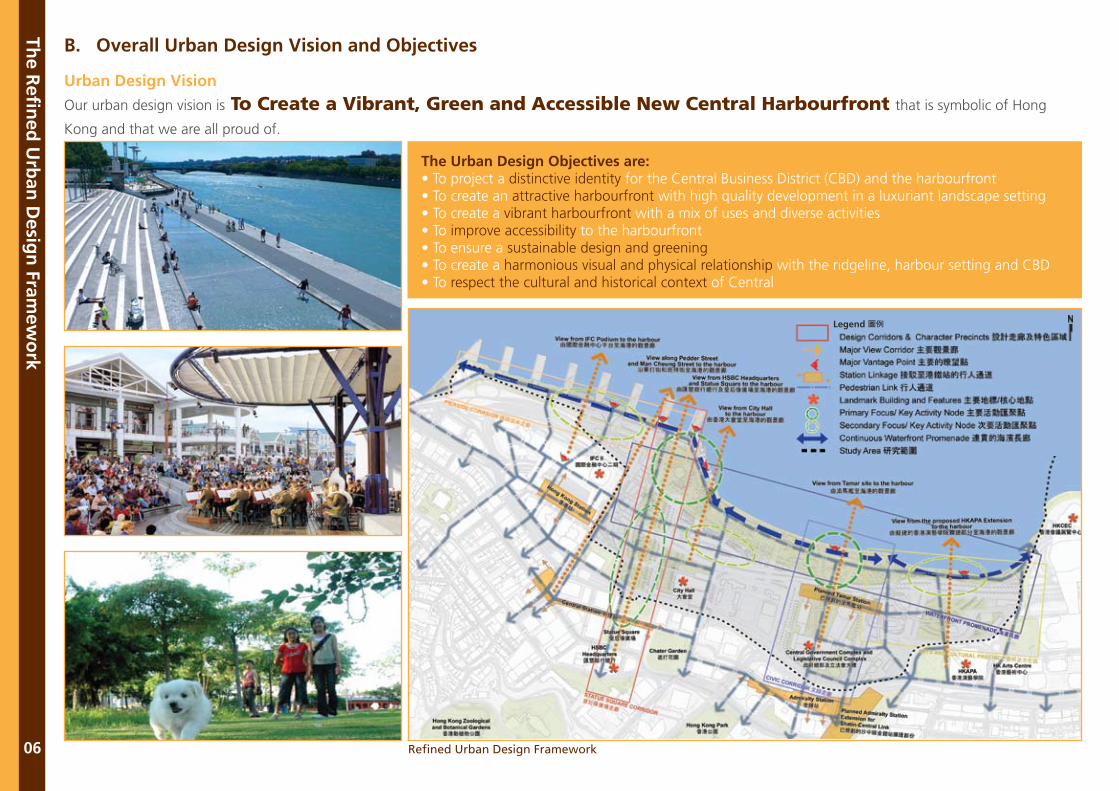
B. Overall Urban Design Vision and Objectives
Urban Design Vision
Our urban design vision is To Create a Vibrant, Green and Accessible New Central Harbourfront that is symbolic of Hong
Kong and that we are all proud of.
The Urban Design Objectives are: • To project a distinctive identity for the Central Business District (CBD) and the harbourfront• To create an attractive harbourfront with high quality development in a luxuriant landscape setting• To create a vibrant harbourfront with a mix of uses and diverse activities • To improve accessibility to the harbourfront• To ensure a sustainable design and greening• To create a harmonious visual and physical relationship with the ridgeline, harbour setting and CBD• To respect the cultural and historical context of Central
Refined Urban Design Framework
The R
efin
ed U
rban
Desig
n Fram
ewo
rk
07
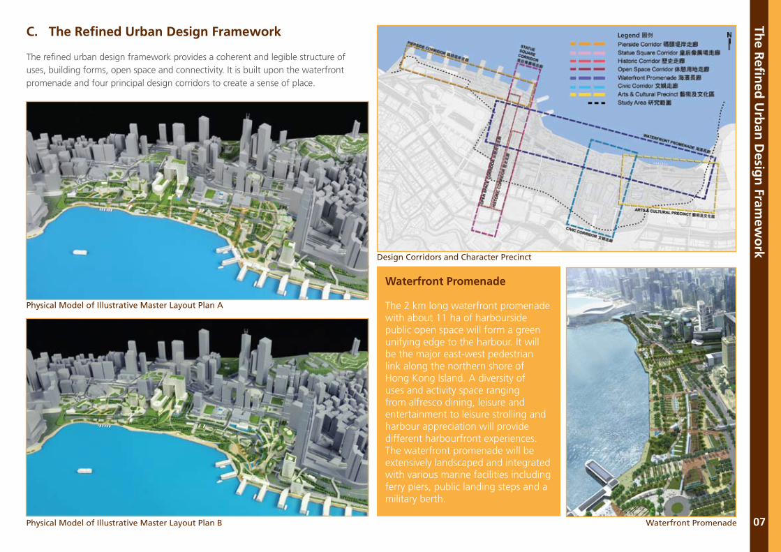
Physical Model of Illustrative Master Layout Plan A
Design Corridors and Character Precinct
Physical Model of Illustrative Master Layout Plan B Waterfront Promenade
C. The Refined Urban Design Framework
The refined urban design framework provides a coherent and legible structure of uses, building forms, open space and connectivity. It is built upon the waterfront promenade and four principal design corridors to create a sense of place.
Waterfront Promenade
The 2 km long waterfront promenade with about 11 ha of harbourside public open space will form a green unifying edge to the harbour. It will be the major east-west pedestrian link along the northern shore of Hong Kong Island. A diversity of uses and activity space ranging from alfresco dining, leisure and entertainment to leisure strolling and harbour appreciation will provide different harbourfront experiences. The waterfront promenade will be extensively landscaped and integrated with various marine facilities including ferry piers, public landing steps and a military berth.
The R
efin
ed U
rban
Desig
n Fram
ewo
rk
08
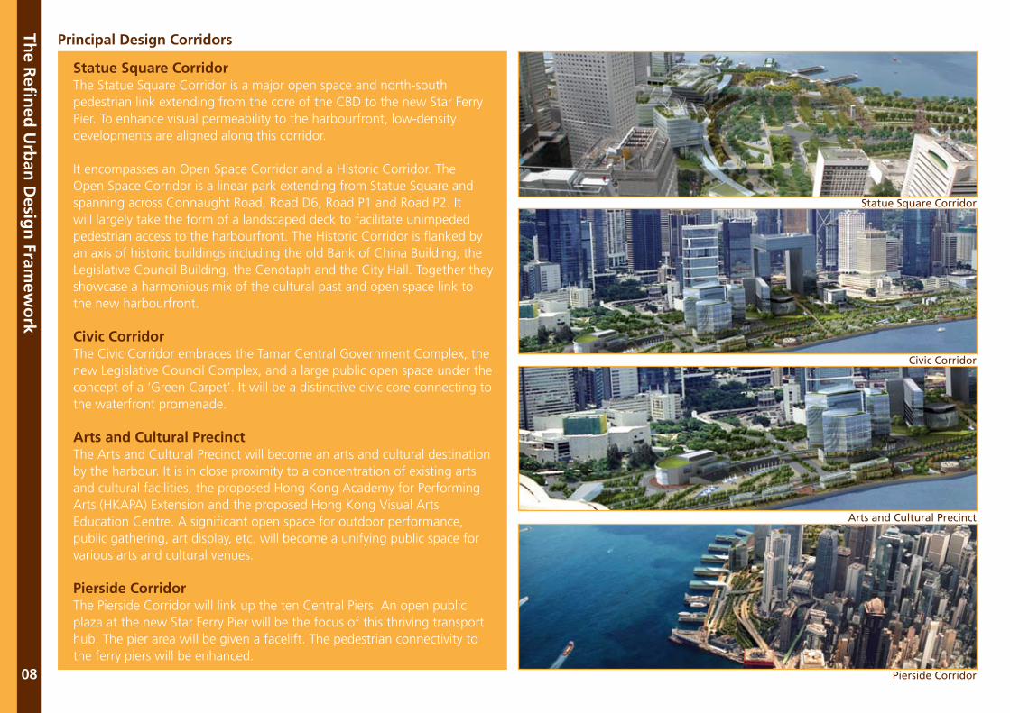
Principal Design Corridors
Statue Square CorridorThe Statue Square Corridor is a major open space and north-south pedestrian link extending from the core of the CBD to the new Star Ferry Pier. To enhance visual permeability to the harbourfront, low-density developments are aligned along this corridor.
It encompasses an Open Space Corridor and a Historic Corridor. The Open Space Corridor is a linear park extending from Statue Square and spanning across Connaught Road, Road D6, Road P1 and Road P2. It will largely take the form of a landscaped deck to facilitate unimpeded pedestrian access to the harbourfront. The Historic Corridor is flanked by an axis of historic buildings including the old Bank of China Building, the Legislative Council Building, the Cenotaph and the City Hall. Together they showcase a harmonious mix of the cultural past and open space link to the new harbourfront.
Civic CorridorThe Civic Corridor embraces the Tamar Central Government Complex, the new Legislative Council Complex, and a large public open space under the concept of a ‘Green Carpet’. It will be a distinctive civic core connecting to the waterfront promenade.
Arts and Cultural PrecinctThe Arts and Cultural Precinct will become an arts and cultural destination by the harbour. It is in close proximity to a concentration of existing arts and cultural facilities, the proposed Hong Kong Academy for Performing Arts (HKAPA) Extension and the proposed Hong Kong Visual Arts Education Centre. A significant open space for outdoor performance, public gathering, art display, etc. will become a unifying public space for various arts and cultural venues.
Pierside CorridorThe Pierside Corridor will link up the ten Central Piers. An open public plaza at the new Star Ferry Pier will be the focus of this thriving transport hub. The pier area will be given a facelift. The pedestrian connectivity to the ferry piers will be enhanced.
Statue Square Corridor
Civic Corridor
Arts and Cultural Precinct
Pierside Corridor
The R
efin
ed U
rban
Desig
n Fram
ewo
rk
09
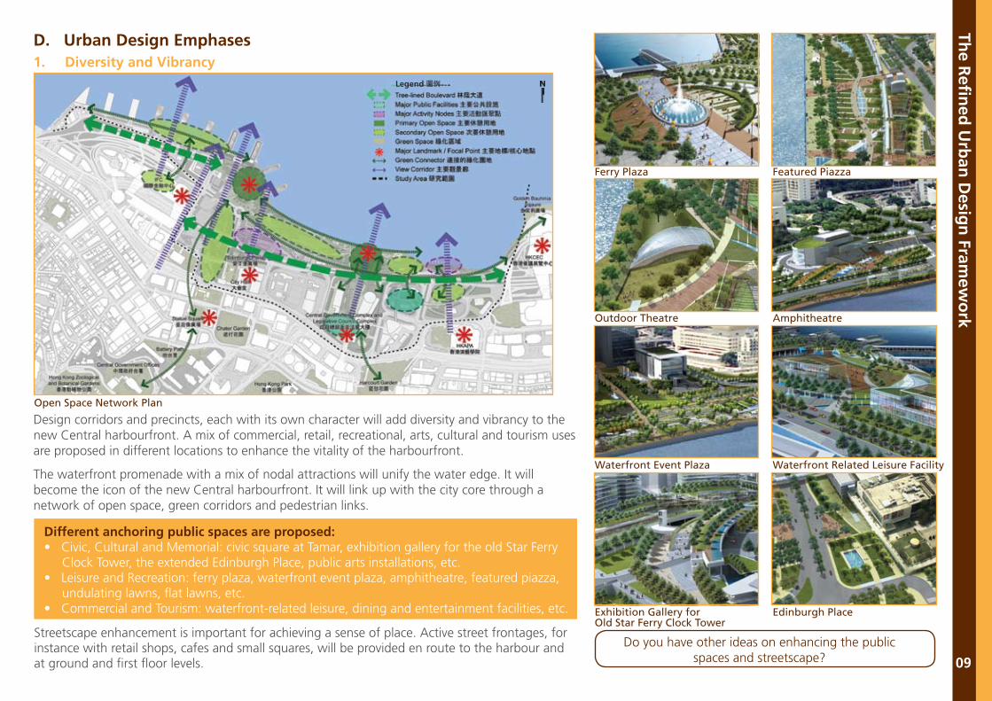
Design corridors and precincts, each with its own character will add diversity and vibrancy to the new Central harbourfront. A mix of commercial, retail, recreational, arts, cultural and tourism uses are proposed in different locations to enhance the vitality of the harbourfront.
The waterfront promenade with a mix of nodal attractions will unify the water edge. It will become the icon of the new Central harbourfront. It will link up with the city core through a network of open space, green corridors and pedestrian links.
Streetscape enhancement is important for achieving a sense of place. Active street frontages, for instance with retail shops, cafes and small squares, will be provided en route to the harbour and at ground and first floor levels.
Different anchoring public spaces are proposed:• Civic, Cultural and Memorial: civic square at Tamar, exhibition gallery for the old Star Ferry Clock Tower, the extended Edinburgh Place, public arts installations, etc.• Leisure and Recreation: ferry plaza, waterfront event plaza, amphitheatre, featured piazza, undulating lawns, flat lawns, etc.• Commercial and Tourism: waterfront-related leisure, dining and entertainment facilities, etc.
Open Space Network Plan
Exhibition Gallery forOld Star Ferry Clock Tower
Waterfront Event Plaza
Outdoor Theatre
Ferry Plaza
Edinburgh Place
Waterfront Related Leisure Facility
Amphitheatre
Featured Piazza
Do you have other ideas on enhancing the public spaces and streetscape?
D. Urban Design Emphases1. Diversity and Vibrancy
The R
efin
ed U
rban
Desig
n Fram
ewo
rk
10
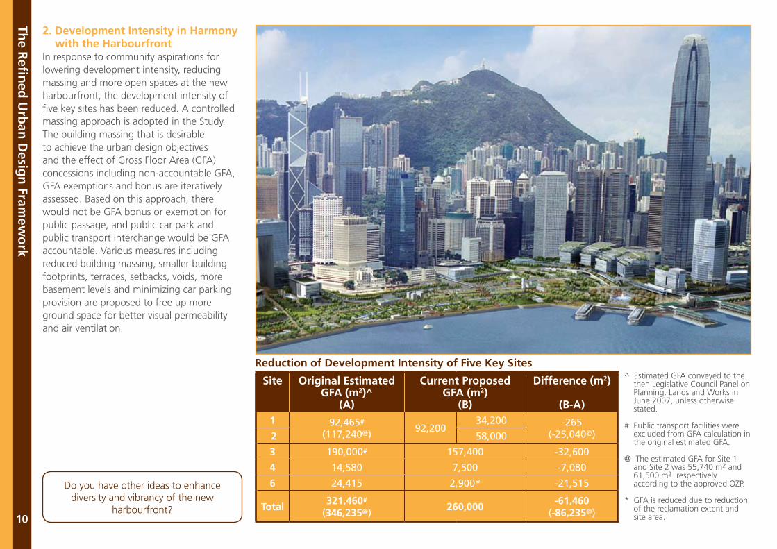
2. Development Intensity in Harmony with the HarbourfrontIn response to community aspirations for lowering development intensity, reducing massing and more open spaces at the new harbourfront, the development intensity of five key sites has been reduced. A controlled massing approach is adopted in the Study. The building massing that is desirable to achieve the urban design objectives and the effect of Gross Floor Area (GFA) concessions including non-accountable GFA, GFA exemptions and bonus are iteratively assessed. Based on this approach, there would not be GFA bonus or exemption for public passage, and public car park and public transport interchange would be GFA accountable. Various measures including reduced building massing, smaller building footprints, terraces, setbacks, voids, more basement levels and minimizing car parking provision are proposed to free up more ground space for better visual permeability and air ventilation.
Do you have other ideas to enhance diversity and vibrancy of the new
harbourfront?
Site Original EstimatedGFA (m2)^
(A)
Current Proposed GFA (m2)
(B)
Difference (m2)
(B-A)1 92,465#
(117,240@)92,200
34,200 -265(-25,040@) 2 58,000
3 190,000# 157,400 -32,600
4 14,580 7,500 -7,080
6 24,415 2,900* -21,515
Total321,460#
(346,235@)260,000
-61,460(-86,235@)
Reduction of Development Intensity of Five Key Sites^ Estimated GFA conveyed to the then Legislative Council Panel on Planning, Lands and Works in June 2007, unless otherwise stated.
# Public transport facilities were excluded from GFA calculation in the original estimated GFA.
@ The estimated GFA for Site 1 and Site 2 was 55,740 m2 and 61,500 m2 respectively according to the approved OZP.
* GFA is reduced due to reduction of the reclamation extent and site area.
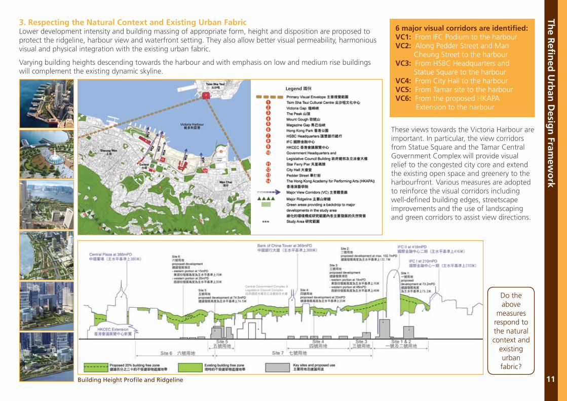
3. Respecting the Natural Context and Existing Urban FabricLower development intensity and building massing of appropriate form, height and disposition are proposed to protect the ridgeline, harbour view and waterfront setting. They also allow better visual permeability, harmonious visual and physical integration with the existing urban fabric.
Varying building heights descending towards the harbour and with emphasis on low and medium rise buildings will complement the existing dynamic skyline.
Do the above
measures respond to the natural context and
existing urban fabric?
Building Height Profile and Ridgeline
6 major visual corridors are identified:VC1: From IFC Podium to the harbourVC2: Along Pedder Street and Man Cheung Street to the harbourVC3: From HSBC Headquarters and Statue Square to the harbourVC4: From City Hall to the harbourVC5: From Tamar site to the harbourVC6: From the proposed HKAPA Extension to the harbour
These views towards the Victoria Harbour are important. In particular, the view corridors from Statue Square and the Tamar Central Government Complex will provide visual relief to the congested city core and extend the existing open space and greenery to the harbourfront. Various measures are adopted to reinforce the visual corridors including well-defined building edges, streetscape improvements and the use of landscaping and green corridors to assist view directions.
The R
efin
ed U
rban
Desig
n Fram
ewo
rk
11
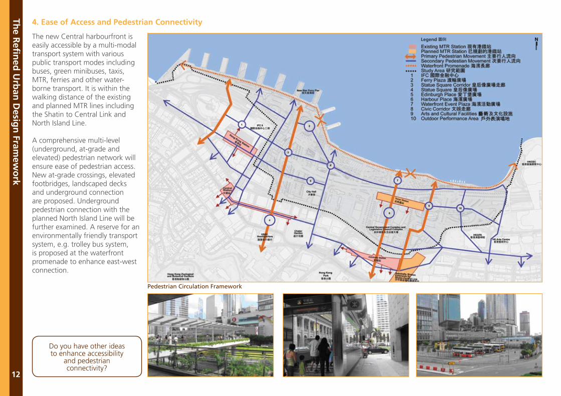
Pedestrian Circulation Framework
4. Ease of Access and Pedestrian Connectivity
The R
efin
ed U
rban
Desig
n Fram
ewo
rk
12
The new Central harbourfront is easily accessible by a multi-modal transport system with various public transport modes including buses, green minibuses, taxis, MTR, ferries and other water-borne transport. It is within the walking distance of the existing and planned MTR lines including the Shatin to Central Link and North Island Line.
A comprehensive multi-level (underground, at-grade and elevated) pedestrian network will ensure ease of pedestrian access. New at-grade crossings, elevated footbridges, landscaped decks and underground connection are proposed. Underground pedestrian connection with the planned North Island Line will be further examined. A reserve for an environmentally friendly transport system, e.g. trolley bus system, is proposed at the waterfront promenade to enhance east-west connection.
Do you have other ideas to enhance accessibility
and pedestrian connectivity?
The R
efin
ed U
rban
Desig
n Fram
ewo
rk
13
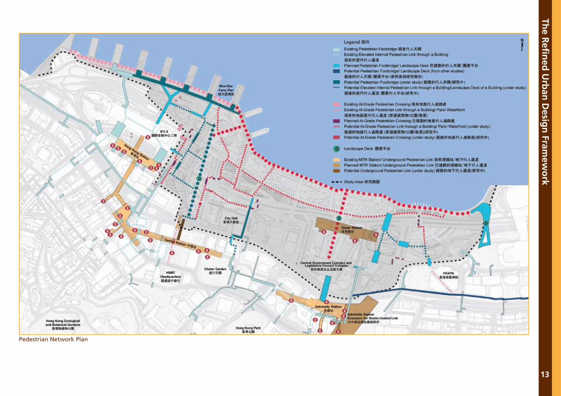
Pedestrian Network Plan
The R
efin
ed U
rban
Desig
n Fram
ewo
rk
14
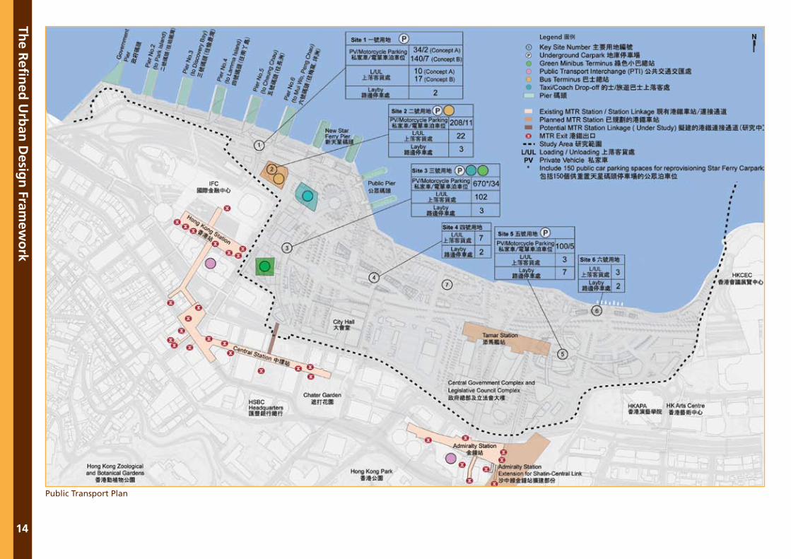
Public Transport Plan
The R
efin
ed U
rban
Desig
n Fram
ewo
rk
15
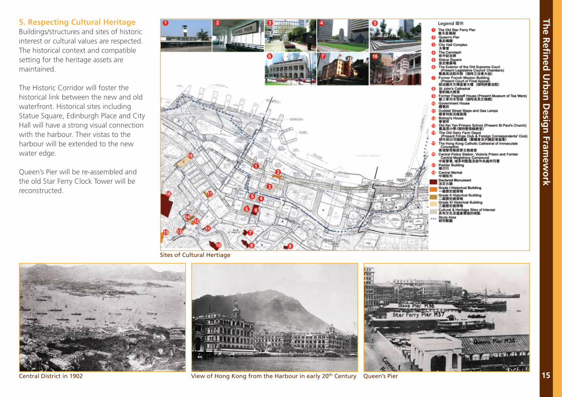
5. Respecting Cultural HeritageBuildings/structures and sites of historic interest or cultural values are respected. The historical context and compatible setting for the heritage assets are maintained.
The Historic Corridor will foster the historical link between the new and old waterfront. Historical sites including Statue Square, Edinburgh Place and City Hall will have a strong visual connection with the harbour. Their vistas to the harbour will be extended to the new water edge.
Queen’s Pier will be re-assembled and the old Star Ferry Clock Tower will be reconstructed.
Central District in 1902 View of Hong Kong from the Harbour in early 20th Century
Sites of Cultural Hertiage
Queen’s Pier
The R
efin
ed U
rban
Desig
n Fram
ewo
rk
16
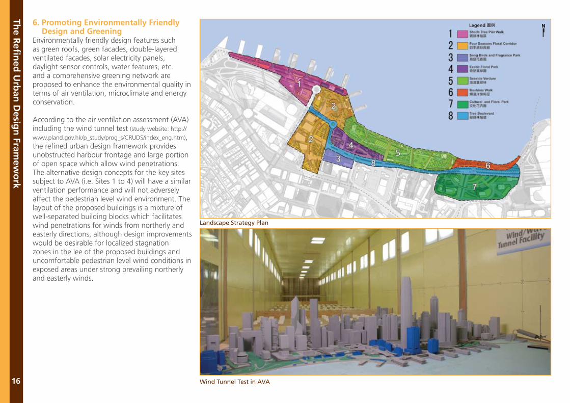
6. Promoting Environmentally Friendly Design and GreeningEnvironmentally friendly design features such as green roofs, green facades, double-layered ventilated facades, solar electricity panels, daylight sensor controls, water features, etc. and a comprehensive greening network are proposed to enhance the environmental quality in terms of air ventilation, microclimate and energy conservation.
According to the air ventilation assessment (AVA) including the wind tunnel test (study website: http://
www.pland.gov.hk/p_study/prog_s/CRUDS/index_eng.htm), the refined urban design framework provides unobstructed harbour frontage and large portion of open space which allow wind penetrations. The alternative design concepts for the key sites subject to AVA (i.e. Sites 1 to 4) will have a similar ventilation performance and will not adversely affect the pedestrian level wind environment. The layout of the proposed buildings is a mixture of well-separated building blocks which facilitates wind penetrations for winds from northerly and easterly directions, although design improvements would be desirable for localized stagnation zones in the lee of the proposed buildings and uncomfortable pedestrian level wind conditions in exposed areas under strong prevailing northerly and easterly winds.
Landscape Strategy Plan
Wind Tunnel Test in AVA
Exotic Floral Park
Song Birds and Fragrance Park
Four Seasons Floral Corridor
Shade Tree Pier Walk
Tree Boulevard
Cultural and Floral Park
Bauhinia Walk
Seaside Verdure
Do you have other ideas on achieving sustainable design?
The R
efin
ed U
rban
Desig
n Fram
ewo
rk
17
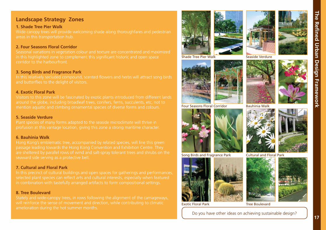
Landscape Strategy Zones1. Shade Tree Pier WalkWide canopy trees will provide welcoming shade along thoroughfares and pedestrian areas in this transportation hub.
2. Four Seasons Floral CorridorSeasonal variations in vegetation colour and texture are concentrated and maximized in this highlighted zone to complement this significant historic and open space corridor to the harbourfront.
3. Song Birds and Fragrance ParkIn this relatively secluded compound, scented flowers and herbs will attract song birds and butterflies to the delight of visitors.
4. Exotic Floral ParkVisitors to this zone will be fascinated by exotic plants introduced from different lands around the globe, including broadleaf trees, conifers, ferns, succulents, etc, not to mention aquatic and climbing ornamental species of diverse forms and colours.
5. Seaside VerdurePlant species of many forms adapted to the seaside microclimate will thrive in profusion at this vantage location, giving this zone a strong maritime character.
6. Bauhinia WalkHong Kong’s emblematic tree, accompanied by related species, will line this green passage leading towards the Hong Kong Convention and Exhibition Centre. They are sheltered by parallel rows of wind and salt-spray tolerant trees and shrubs on the seaward side serving as a protective belt.
7. Cultural and Floral ParkIn this precinct of cultural buildings and open spaces for gatherings and performances, selected plant species can reflect arts and cultural interests, especially when featured in combination with tastefully arranged artifacts to form compositional settings.
8. Tree BoulevardStately and wide-canopy trees, in rows following the alignment of the carriageways, will reinforce the sense of movement and direction, while contributing to climatic amelioration during the hot summer months.
Desig
n C
on
cepts fo
r Key Sites
18
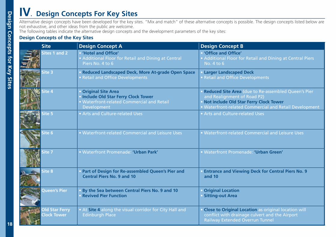
Site Design Concept A Design Concept BSites 1 and 2 • ‘Hotel and Office’
• Additional Floor for Retail and Dining at Central Piers No. 4 to 6
• ‘Office and Office’• Additional Floor for Retail and Dining at Central Piers No. 4 to 6
Site 3 • Reduced Landscaped Deck, More At-grade Open Space• Retail and Office Developments
• Larger Landscaped Deck• Retail and Office Developments
Site 4 • Original Site Area• Include Old Star Ferry Clock Tower• Waterfront-related Commercial and Retail Development
• Reduced Site Area (due to Re-assembled Queen’s Pier and Realignment of Road P2)• Not include Old Star Ferry Clock Tower• Waterfront-related Commercial and Retail Development
Site 5 • Arts and Culture-related Uses • Arts and Culture-related Uses
Site 6 • Waterfront-related Commercial and Leisure Uses • Waterfront-related Commercial and Leisure Uses
Site 7 • Waterfront Promenade: ‘Urban Park’ • Waterfront Promenade: ‘Urban Green’
Site 8 • Part of Design for Re-assembled Queen’s Pier and Central Piers No. 9 and 10
• Entrance and Viewing Deck for Central Piers No. 9 and 10
Queen’s Pier • By the Sea between Central Piers No. 9 and 10 • Revived Pier Function
• Original Location• Sitting-out Area
Old Star FerryClock Tower
• At Site 4 along the visual corridor for City Hall and Edinburgh Place
• Close to Original Location as original location will conflict with drainage culvert and the Airport Railway Extended Overrun Tunnel
IV. Design Concepts For Key SitesAlternative design concepts have been developed for the key sites. “Mix and match” of these alternative concepts is possible. The design concepts listed below are not exhaustive, and other ideas from the public are welcome.The following tables indicate the alternative design concepts and the development parameters of the key sites:
Design Concepts of the Key Sites
Desig
n C
on
cepts fo
r Key Sites
19
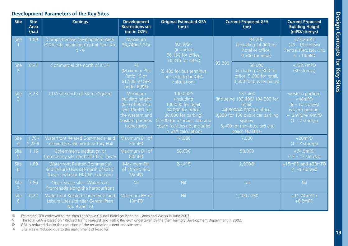
Development Parameters of the Key Sites
※ Estimated GFA conveyed to the then Legislative Council Panel on Planning, Lands and Works in June 2007.^ The total GFA is based on “Revised Traffic Forecast and Traffic Review” undertaken by the then Territory Development Department in 2002.@ GFA is reduced due to the reduction of the reclamation extent and site area.⊕ Site area is reduced due to the realignment of Road P2.
Site Site Area(ha.)
Zonings Development Restrictions set
out in OZPs
Original Estimated GFA (m2)※
Current Proposed GFA(m2)
Current Proposed Building Height(mPD/storeys)
Site 1
1.89 Comprehensive Development Area (CDA) site adjoining Central Piers No.
4 - 6
Maximum 55,740m2 GFA 92,465^
(including76,150 for office;16,315 for retail)
(5,400 for bus terminusnot included in GFA
calculation)
92,200
34,200 (including 24,900 for
hotel or office; 9,300 for retail)
+73.2mPD(16 - 18 storeys)
Central Piers No. 4 to 6: +19mPD
Site 2
0.41 Commercial site north of IFC II Nil(Maximum Plot
Ratio 15 or 61,500 m2 GFA
under B(P)R)
58,000 (including 48,800 for
office; 5,600 for retail,3,600 for bus terminus)
+132.7mPD(30 storeys)
Site 3
5.23 CDA site north of Statue Square Maximum building height (BH) of 50mPD and 16mPD for the western and eastern portions
respectively
190,000^(including
106,000 for retail;54,000 for office;
30,000 for parking)(5,400 for mini-bus, taxi and coach facilities not included
in GFA calculation)
157,400(including 103,400/ 104,200 for
retail;44,800/44,000 for office;
3,800 for 150 public car parking spaces;
5,400 for mini-bus, taxi and coach facilities)
western portion: +48mPD
(8 – 10 storeys)eastern portion:
+12mPD/+16mPD(1 – 2 storeys)
Site 4
1.70 / 1.22⊕
Waterfront Related Commercial and Leisure Uses site north of City Hall
Maximum BH of 25mPD
14,580 7,500 +20mPD(1 – 3 storeys)
Site 5
1.16 Government, Institution or Community site north of CITIC Tower
Maximum BH of 80mPD
58,000 58,000 +74.5mPD(13 – 17 storeys)
Site 6
1.89 Waterfront Related Commercial and Leisure Uses site north of CITIC Tower and near HKCEC Extension
Maximum BH of 15mPD and
25mPD
24,415 2,900@ +15mPD and +20mPD(1 –3 storeys)
Site 7
7.80 Open Space site – Waterfront Promenade along the harbourfront
Nil Nil Nil Nil
Site 8
0.22 Waterfront Related Commercial and Leisure Uses site near Central Piers
No. 9 and 10
Maximum BH of 13mPD
Nil 1,200 / 850 +11.24mPD / +8.2mPD
Desig
n C
on
cepts fo
r Key Sites
20
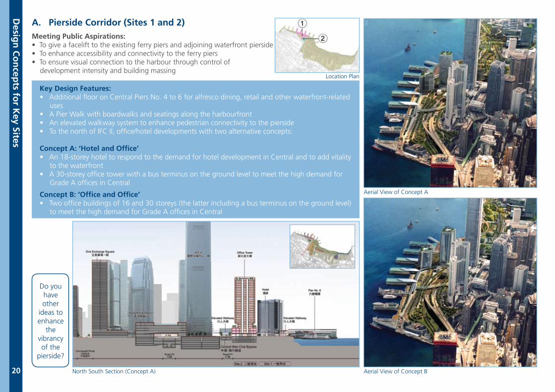
A. Pierside Corridor (Sites 1 and 2)Meeting Public Aspirations: • To give a facelift to the existing ferry piers and adjoining waterfront pierside• To enhance accessibility and connectivity to the ferry piers• To ensure visual connection to the harbour through control of development intensity and building massing
Key Design Features: • Additional floor on Central Piers No. 4 to 6 for alfresco dining, retail and other waterfront-related uses• A Pier Walk with boardwalks and seatings along the harbourfront• An elevated walkway system to enhance pedestrian connectivity to the pierside• To the north of IFC II, office/hotel developments with two alternative concepts:
Concept A: ‘Hotel and Office’• An 18-storey hotel to respond to the demand for hotel development in Central and to add vitality to the waterfront• A 30-storey office tower with a bus terminus on the ground level to meet the high demand for Grade A offices in Central
Concept B: ‘Office and Office’• Two office buildings of 16 and 30 storeys (the latter including a bus terminus on the ground level) to meet the high demand for Grade A offices in Central
Do you have other
ideas to enhance
the vibrancy of the
pierside?
Aerial View of Concept BNorth South Section (Concept A)
Aerial View of Concept A
Location Plan
Desig
n C
on
cepts fo
r Key Sites
21
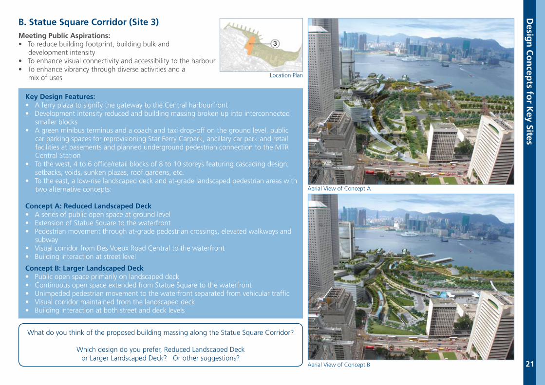
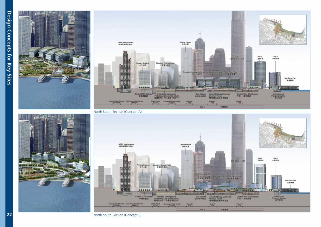
B. Statue Square Corridor (Site 3)Meeting Public Aspirations: • To reduce building footprint, building bulk and development intensity• To enhance visual connectivity and accessibility to the harbour • To enhance vibrancy through diverse activities and a mix of uses
Key Design Features:• A ferry plaza to signify the gateway to the Central harbourfront• Development intensity reduced and building massing broken up into interconnected smaller blocks• A green minibus terminus and a coach and taxi drop-off on the ground level, public car parking spaces for reprovisioning Star Ferry Carpark, ancillary car park and retail facilities at basements and planned underground pedestrian connection to the MTR Central Station• To the west, 4 to 6 office/retail blocks of 8 to 10 storeys featuring cascading design, setbacks, voids, sunken plazas, roof gardens, etc. • To the east, a low-rise landscaped deck and at-grade landscaped pedestrian areas with two alternative concepts:
Concept A: Reduced Landscaped Deck • A series of public open space at ground level • Extension of Statue Square to the waterfront• Pedestrian movement through at-grade pedestrian crossings, elevated walkways and subway• Visual corridor from Des Voeux Road Central to the waterfront• Building interaction at street level
Concept B: Larger Landscaped Deck• Public open space primarily on landscaped deck• Continuous open space extended from Statue Square to the waterfront• Unimpeded pedestrian movement to the waterfront separated from vehicular traffic• Visual corridor maintained from the landscaped deck• Building interaction at both street and deck levels
Location Plan
What do you think of the proposed building massing along the Statue Square Corridor?
Which design do you prefer, Reduced Landscaped Deckor Larger Landscaped Deck? Or other suggestions?
Aerial View of Concept B
Aerial View of Concept A
Desig
n C
on
cepts fo
r Key Sites
22
North South Section (Concept A)
North South Section (Concept B)
Desig
n C
on
cepts fo
r Key Sites
23
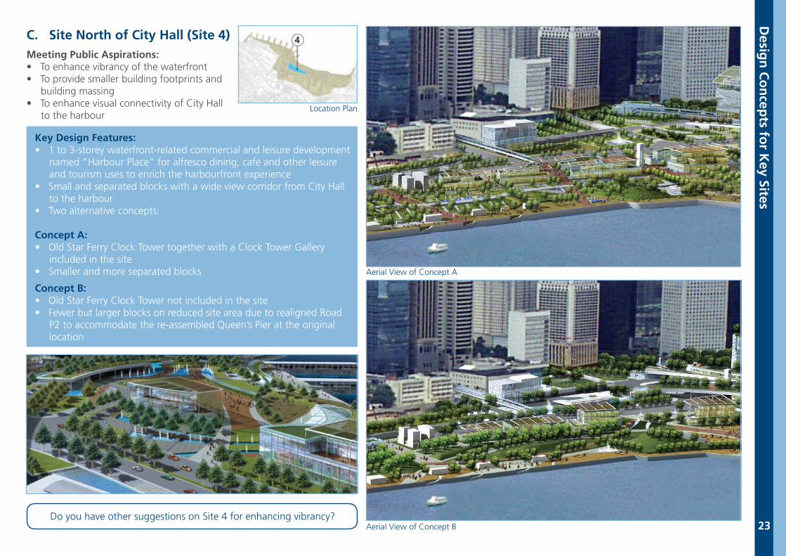
C. Site North of City Hall (Site 4)Meeting Public Aspirations: • To enhance vibrancy of the waterfront• To provide smaller building footprints and building massing• To enhance visual connectivity of City Hall to the harbour
Key Design Features:• 1 to 3-storey waterfront-related commercial and leisure development named “Harbour Place” for alfresco dining, café and other leisure and tourism uses to enrich the harbourfront experience• Small and separated blocks with a wide view corridor from City Hall to the harbour• Two alternative concepts:
Concept A: • Old Star Ferry Clock Tower together with a Clock Tower Gallery included in the site• Smaller and more separated blocks
Concept B: • Old Star Ferry Clock Tower not included in the site• Fewer but larger blocks on reduced site area due to realigned Road P2 to accommodate the re-assembled Queen’s Pier at the original location
Do you have other suggestions on Site 4 for enhancing vibrancy?Aerial View of Concept B
Aerial View of Concept A
Location Plan
24
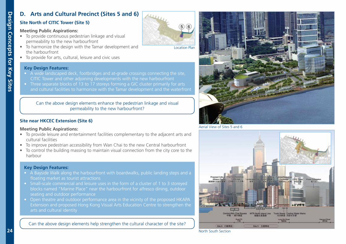
D. Arts and Cultural Precinct (Sites 5 and 6)Site North of CITIC Tower (Site 5)
Meeting Public Aspirations: • To provide continuous pedestrian linkage and visual permeability to the new harbourfront• To harmonize the design with the Tamar development and the harbourfront• To provide for arts, cultural, leisure and civic uses
Key Design Features:• A wide landscaped deck, footbridges and at-grade crossings connecting the site, CITIC Tower and other adjoining developments with the new harbourfront• Three separate blocks of 13 to 17 storeys forming a GIC cluster primarily for arts and cultural facilities to harmonize with the Tamar development and the waterfront
Key Design Features:• A Bayside Walk along the harbourfront with boardwalks, public landing steps and a floating market as tourist attractions• Small-scale commercial and leisure uses in the form of a cluster of 1 to 3 storeyed blocks named “Marine Place” near the harbourfront for alfresco dining, outdoor seating and outdoor performance• Open theatre and outdoor performance area in the vicinity of the proposed HKAPA Extension and proposed Hong Kong Visual Arts Education Centre to strengthen the arts and cultural identity
Site near HKCEC Extension (Site 6)
Meeting Public Aspirations:• To provide leisure and entertainment facilities complementary to the adjacent arts and cultural facilities• To improve pedestrian accessibility from Wan Chai to the new Central harbourfront• To control the building massing to maintain visual connection from the city core to the harbour
North South Section
Aerial View of Sites 5 and 6
Can the above design elements help strengthen the cultural character of the site?
Can the above design elements enhance the pedestrian linkage and visual permeability to the new harbourfront?
Location Plan
Desig
n C
on
cepts fo
r Key Sites
25
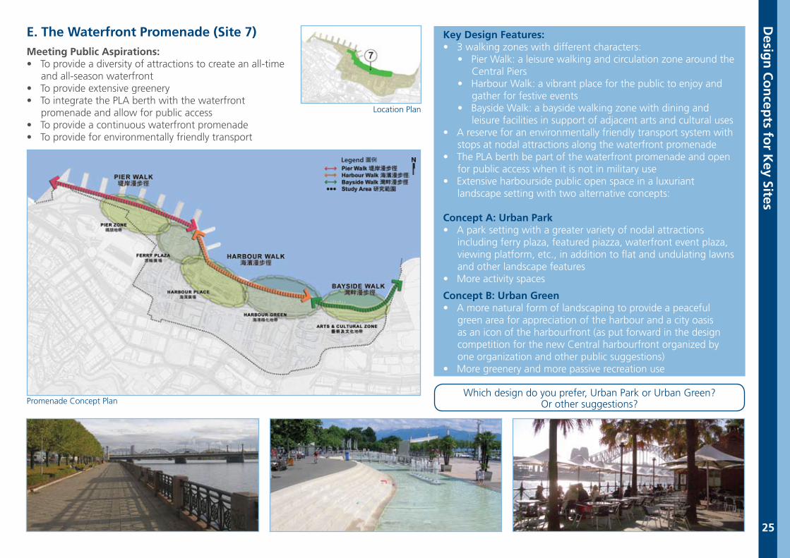
E. The Waterfront Promenade (Site 7)Meeting Public Aspirations:• To provide a diversity of attractions to create an all-time and all-season waterfront• To provide extensive greenery• To integrate the PLA berth with the waterfront promenade and allow for public access• To provide a continuous waterfront promenade• To provide for environmentally friendly transport
Key Design Features:• 3 walking zones with different characters: • Pier Walk: a leisure walking and circulation zone around the Central Piers • Harbour Walk: a vibrant place for the public to enjoy and gather for festive events • Bayside Walk: a bayside walking zone with dining and leisure facilities in support of adjacent arts and cultural uses• A reserve for an environmentally friendly transport system with stops at nodal attractions along the waterfront promenade• The PLA berth be part of the waterfront promenade and open for public access when it is not in military use• Extensive harbourside public open space in a luxuriant landscape setting with two alternative concepts:
Concept A: Urban Park• A park setting with a greater variety of nodal attractions including ferry plaza, featured piazza, waterfront event plaza, viewing platform, etc., in addition to flat and undulating lawns and other landscape features• More activity spaces
Concept B: Urban Green• A more natural form of landscaping to provide a peaceful green area for appreciation of the harbour and a city oasis as an icon of the harbourfront (as put forward in the design competition for the new Central harbourfront organized by one organization and other public suggestions)• More greenery and more passive recreation use
Promenade Concept PlanWhich design do you prefer, Urban Park or Urban Green?
Or other suggestions?
Location Plan
Desig
n C
on
cepts fo
r Key Sites
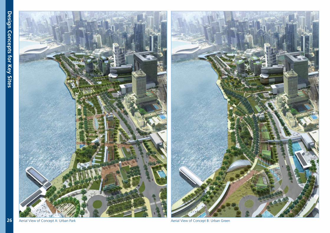
26 Aerial View of Concept A: Urban Park Aerial View of Concept B: Urban Green
Desig
n C
on
cepts fo
r Key Sites
27
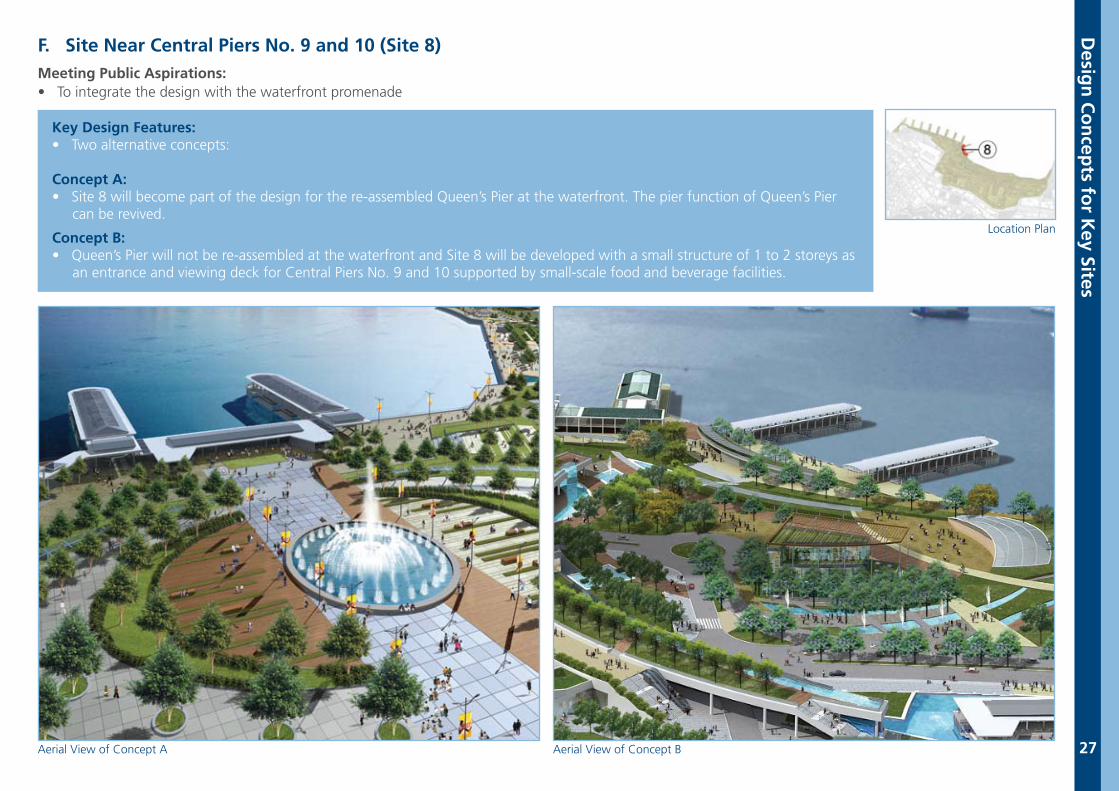
F. Site Near Central Piers No. 9 and 10 (Site 8)Meeting Public Aspirations: • To integrate the design with the waterfront promenade
Key Design Features:• Two alternative concepts:
Concept A: • Site 8 will become part of the design for the re-assembled Queen’s Pier at the waterfront. The pier function of Queen’s Pier can be revived.
Concept B: • Queen’s Pier will not be re-assembled at the waterfront and Site 8 will be developed with a small structure of 1 to 2 storeys as an entrance and viewing deck for Central Piers No. 9 and 10 supported by small-scale food and beverage facilities.
Aerial View of Concept A Aerial View of Concept B
Location Plan
Desig
n C
on
cepts fo
r Key Sites
28
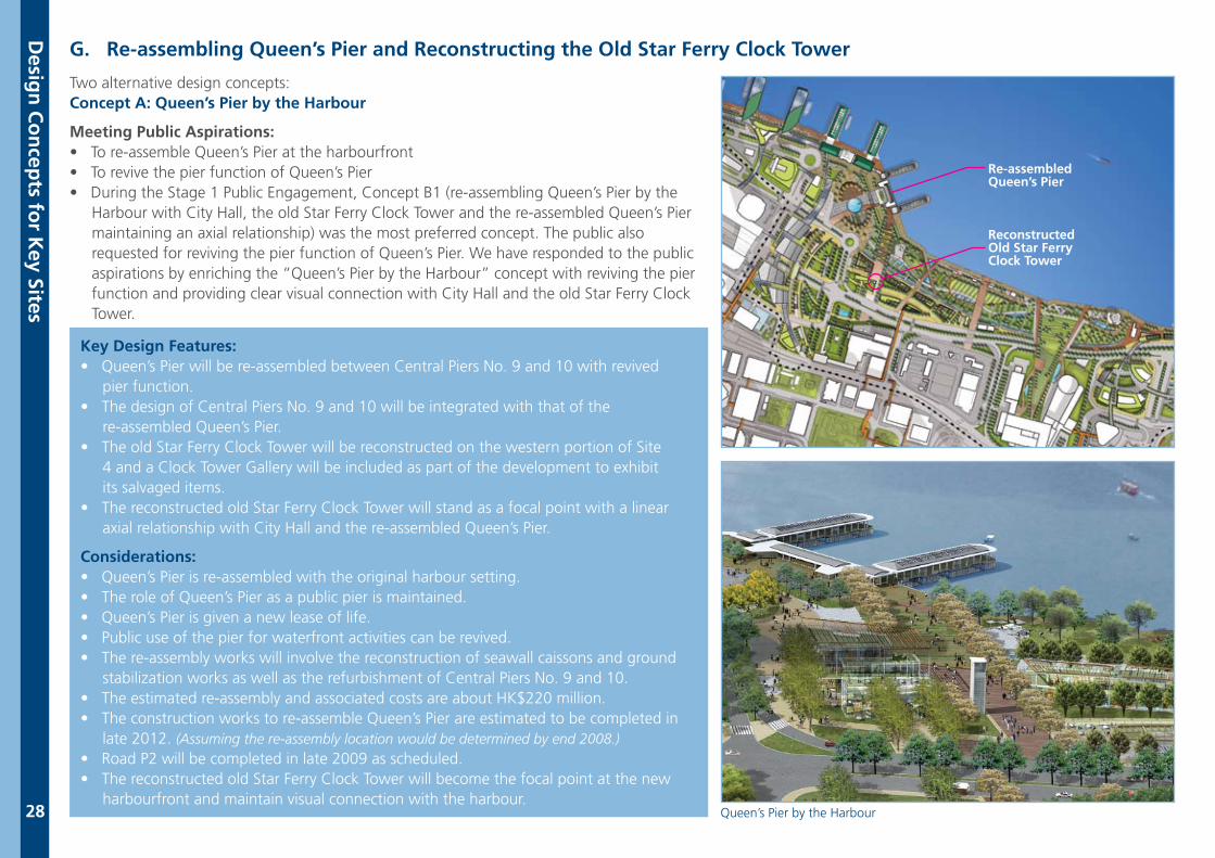
Two alternative design concepts:Concept A: Queen’s Pier by the Harbour
Meeting Public Aspirations:• To re-assemble Queen’s Pier at the harbourfront• To revive the pier function of Queen’s Pier • During the Stage 1 Public Engagement, Concept B1 (re-assembling Queen’s Pier by the Harbour with City Hall, the old Star Ferry Clock Tower and the re-assembled Queen’s Pier maintaining an axial relationship) was the most preferred concept. The public also requested for reviving the pier function of Queen’s Pier. We have responded to the public aspirations by enriching the “Queen’s Pier by the Harbour” concept with reviving the pier function and providing clear visual connection with City Hall and the old Star Ferry Clock Tower.
Key Design Features:• Queen’s Pier will be re-assembled between Central Piers No. 9 and 10 with revived pier function.• The design of Central Piers No. 9 and 10 will be integrated with that of the re-assembled Queen’s Pier.• The old Star Ferry Clock Tower will be reconstructed on the western portion of Site 4 and a Clock Tower Gallery will be included as part of the development to exhibit its salvaged items. • The reconstructed old Star Ferry Clock Tower will stand as a focal point with a linear axial relationship with City Hall and the re-assembled Queen’s Pier.
Considerations:• Queen’s Pier is re-assembled with the original harbour setting.• The role of Queen’s Pier as a public pier is maintained.• Queen’s Pier is given a new lease of life.• Public use of the pier for waterfront activities can be revived. • The re-assembly works will involve the reconstruction of seawall caissons and ground stabilization works as well as the refurbishment of Central Piers No. 9 and 10.• The estimated re-assembly and associated costs are about HK$220 million.• The construction works to re-assemble Queen’s Pier are estimated to be completed in late 2012. (Assuming the re-assembly location would be determined by end 2008.)• Road P2 will be completed in late 2009 as scheduled.• The reconstructed old Star Ferry Clock Tower will become the focal point at the new harbourfront and maintain visual connection with the harbour.
Reconstructed Old Star Ferry Clock Tower
Re-assembledQueen’s Pier
G. Re-assembling Queen’s Pier and Reconstructing the Old Star Ferry Clock Tower
Desig
n C
on
cepts fo
r Key Sites
Queen’s Pier by the Harbour
29
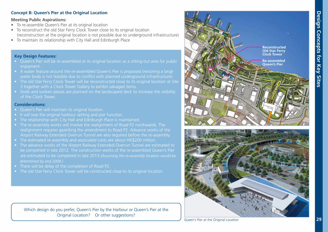
Concept B: Queen’s Pier at the Original Location
Meeting Public Aspirations:• To re-assemble Queen’s Pier at its original location• To reconstruct the old Star Ferry Clock Tower close to its original location (reconstruction at the original location is not possible due to underground infrastructure)• To maintain its relationship with City Hall and Edinburgh Place
Key Design Features:• Queen’s Pier will be re-assembled at its original location as a sitting-out area for public enjoyment.• A water feature around the re-assembled Queen’s Pier is proposed (restoring a large water body is not feasible due to conflict with planned underground infrastructure).• The old Star Ferry Clock Tower will be reconstructed close to its original location at Site 3 together with a Clock Tower Gallery to exhibit salvaged items. • Voids and sunken plazas are planned on the landscaped deck to increase the visibility of the Clock Tower.
Considerations:• Queen’s Pier will maintain its original location.• It will lose the original harbour setting and pier function.• The relationship with City Hall and Edinburgh Place is maintained.• The re-assembly works will involve the realignment of Road P2 northwards. The realignment requires gazetting the amendment to Road P2. Advance works of the Airport Railway Extended Overrun Tunnel are also required before the re-assembly. • The estimated re-assembly and associated costs are about HK$200 million.• The advance works of the Airport Railway Extended Overrun Tunnel are estimated to be completed in late 2012. The construction works of the re-assembled Queen’s Pier are estimated to be completed in late 2013.(Assuming the re-assembly location would be determined by end 2008.)• There will be delay of the completion of Road P2.• The old Star Ferry Clock Tower will be constructed close to its original location.
Which design do you prefer, Queen’s Pier by the Harbour or Queen’s Pier at the Original Location? Or other suggestions?
Reconstructed Old Star Ferry Clock Tower
Re-assembledQueen’s Pier
Desig
n C
on
cepts fo
r Key Sites
Queen’s Pier at the Original Location
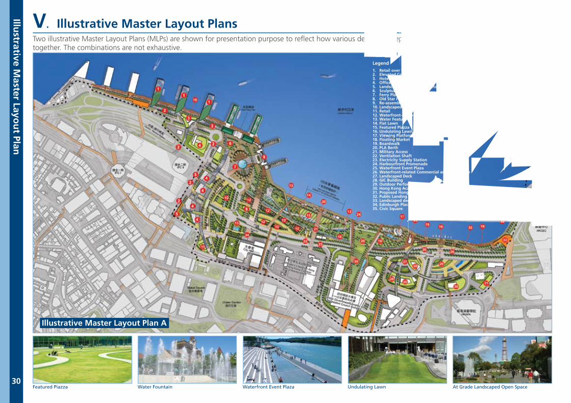
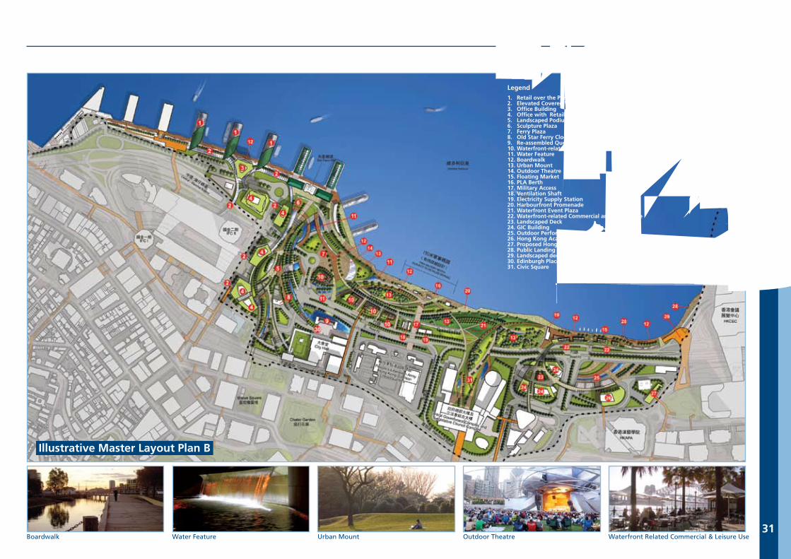
V. Illustrative Master Layout Plans
Illustrative M
aster Layou
t Plan
30Undulating Lawn At Grade Landscaped Open SpaceWaterfront Event PlazaWater FountainFeatured Piazza
Illustrative Master Layout Plan A
Two illustrative Master Layout Plans (MLPs) are shown for presentation purpose to reflect how various design concepts for the key sites can possibly be put together. The combinations are not exhaustive.
Legend 圖例
1. Retail over the Pier 碼頭上蓋之零售商店2. Elevated Covered Walkway 高架行人走廊3. Hotel 酒店4. Office with Retail below 辦公室大樓及低層零售商店5. Landscaped Podium with Retail blow 園景平台及低層零售商店6. Sculpture Plaza 雕塑廣場7. Ferry Plaza 渡輪廣場8. Old Star Ferry Clock Tower and Gallery 舊天星鐘樓及展覽館9. Re-assembled Queen’s Pier 重組的皇后碼頭10. Landscaped Open Space at Grade 地面園林休憩用地11. Retail 零售商店12. Waterfront-related Commercial and Leisure Use 與海濱有關之商業及休憩用地13. Water Feature 水景14. Flat Lawn 草坪15. Featured Piazza 特色廣場16. Undulating Lawn 起伏有致的草坪17. Viewing Platform 觀景台18. Floating Market 水上市場19. Boardwalk 木板步行徑20. PLA Berth 解放軍軍事碼頭21. Military Access 軍用通道22. Ventilation Shaft 通風塔23. Electricity Supply Station 電力供應站24. Harbourfront Promenade 海濱長廊25. Waterfront Event Plaza 海濱活動廣場26. Waterfront-related Commercial and Leisure Use 與海濱有關之商業及休憩用地27. Landscaped Deck 園景平台28. GIC Building 政府、機構或社區用途之建築群29. Outdoor Performance Area 戶外表演場地30. Hong Kong Academy for Performing Arts Extension 香港演藝學院擴建部分31. Proposed Hong Kong Visual Arts Education Centre 擬建之香港視覺藝術中心32. Public Landing Steps 公眾登岸梯級33. Landscaped deck to HKCEC West 通往香港會議展覽中心西面的園景平台34. Edinburgh Place 愛丁堡廣場35. Civic Square 文娛廣場
Illustrative M
aster Layou
t Plan
31Outdoor Theatre Waterfront Related Commercial & Leisure UseUrban MountWater FeatureBoardwalk
Illustrative Master Layout Plan B
Legend 圖例
1. Retail over the Pier 碼頭上蓋之零售商店2. Elevated Covered Walkway 高架行人走廊3. Office Building 辦公室大樓4. Office with Retail below 辦公室大樓及低層零售商店5. Landscaped Podium with Retail blow 園景平台及低層零售商店6. Sculpture Plaza 雕塑廣場7. Ferry Plaza 渡輪廣場8. Old Star Ferry Clock Tower and Gallery 舊天星鐘樓及展覽館9. Re-assembled Queen’s Pier 重組的皇后碼頭10. Waterfront-related Commercial and Leisure Use 與海濱有關之商業及休憩用地11. Water Feature 水景12. Boardwalk 木板步行徑13. Urban Mount 城市小丘14. Outdoor Theatre 露天劇場15. Floating Market 水上市場16. PLA Berth 解放軍軍事碼頭17. Military Access 軍用通道18. Ventilation Shaft 通風塔19. Electricity Supply Station 電力供應站20. Harbourfront Promenade 海濱長廊21. Waterfront Event Plaza 海濱活動廣場22. Waterfront-related Commercial and Leisure Use 與海濱有關之商業及休憩用地23. Landscaped Deck 園景平台24. GIC Building 政府、機構或社區用途之建築群25. Outdoor Performance Area 戶外表演場地26. Hong Kong Academy for Performing Arts Extension 香港演藝學院擴建部分27. Proposed Hong Kong Visual Arts Education Centre 擬建之香港視覺藝術中心28. Public Landing Steps 公眾登岸梯級29. Landscaped deck to HKCEC West 通往香港會議展覽中心西面的園景平台30. Edinburgh Place 愛丁堡廣場31. Civic Square 文娛廣場
32
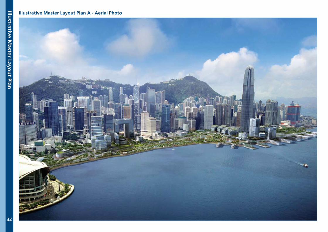
Illustrative Master Layout Plan A - Aerial Photo
Illustrative M
aster Layou
t Plan
33
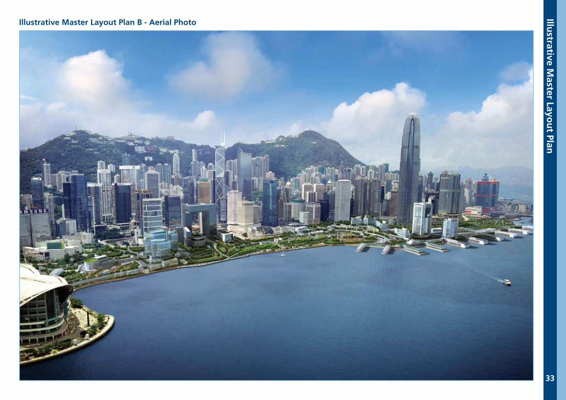
Illustrative Master Layout Plan B - Aerial PhotoIllu
strative Master Layo
ut Plan
A B
alanced
and
Sustain
able A
pp
roach
34
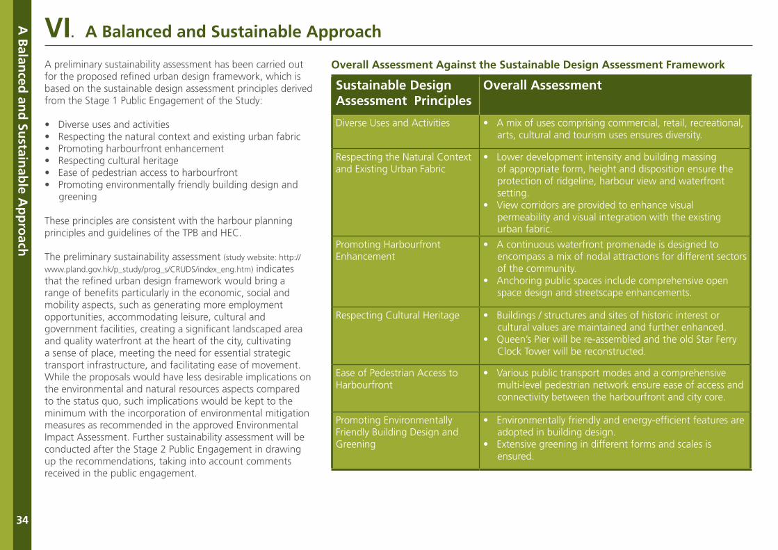
A preliminary sustainability assessment has been carried out for the proposed refined urban design framework, which is based on the sustainable design assessment principles derived from the Stage 1 Public Engagement of the Study:
• Diverse uses and activities• Respecting the natural context and existing urban fabric• Promoting harbourfront enhancement• Respecting cultural heritage• Ease of pedestrian access to harbourfront• Promoting environmentally friendly building design and greening
These principles are consistent with the harbour planning principles and guidelines of the TPB and HEC.
The preliminary sustainability assessment (study website: http://
www.pland.gov.hk/p_study/prog_s/CRUDS/index_eng.htm) indicates that the refined urban design framework would bring a range of benefits particularly in the economic, social and mobility aspects, such as generating more employment opportunities, accommodating leisure, cultural and government facilities, creating a significant landscaped area and quality waterfront at the heart of the city, cultivating a sense of place, meeting the need for essential strategic transport infrastructure, and facilitating ease of movement. While the proposals would have less desirable implications on the environmental and natural resources aspects compared to the status quo, such implications would be kept to the minimum with the incorporation of environmental mitigation measures as recommended in the approved Environmental Impact Assessment. Further sustainability assessment will be conducted after the Stage 2 Public Engagement in drawing up the recommendations, taking into account comments received in the public engagement.
Sustainable Design Assessment Principles
Overall Assessment
Diverse Uses and Activities • A mix of uses comprising commercial, retail, recreational, arts, cultural and tourism uses ensures diversity.
Respecting the Natural Context and Existing Urban Fabric
• Lower development intensity and building massing of appropriate form, height and disposition ensure the protection of ridgeline, harbour view and waterfront setting. • View corridors are provided to enhance visual permeability and visual integration with the existing urban fabric.
Promoting Harbourfront Enhancement
• A continuous waterfront promenade is designed to encompass a mix of nodal attractions for different sectors of the community.• Anchoring public spaces include comprehensive open space design and streetscape enhancements.
Respecting Cultural Heritage • Buildings / structures and sites of historic interest or cultural values are maintained and further enhanced.• Queen’s Pier will be re-assembled and the old Star Ferry Clock Tower will be reconstructed.
Ease of Pedestrian Access to Harbourfront
• Various public transport modes and a comprehensive multi-level pedestrian network ensure ease of access and connectivity between the harbourfront and city core.
Promoting Environmentally Friendly Building Design and Greening
• Environmentally friendly and energy-efficient features are adopted in building design. • Extensive greening in different forms and scales is ensured.
Overall Assessment Against the Sustainable Design Assessment Framework
VI. A Balanced and Sustainable Approach
Pub
lic View
s Sou
gh
t
35
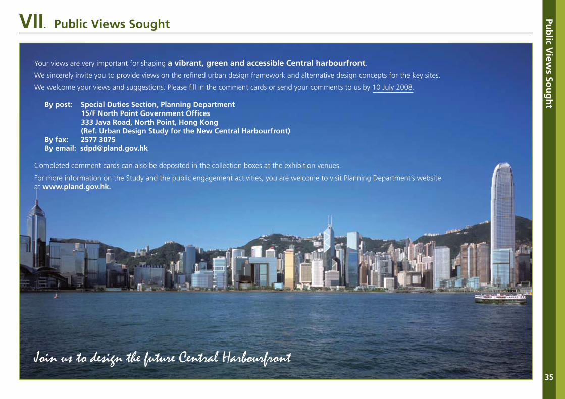
VII. Public Views Sought
Join us to design the future Central Harbourfront
Your views are very important for shaping a vibrant, green and accessible Central harbourfront.
We sincerely invite you to provide views on the refined urban design framework and alternative design concepts for the key sites.
We welcome your views and suggestions. Please fill in the comment cards or send your comments to us by 10 July 2008.
By post: Special Duties Section, Planning Department 15/F North Point Government Offices 333 Java Road, North Point, Hong Kong (Ref. Urban Design Study for the New Central Harbourfront) By fax: 2577 3075 By email: [email protected]
Completed comment cards can also be deposited in the collection boxes at the exhibition venues.
For more information on the Study and the public engagement activities, you are welcome to visit Planning Department’s website at www.pland.gov.hk.

DisclaimerA person or an organization providing any comments and views to the Urban Design Study for the New Central Harbourfront shall be deemed to have given consent to the Planning Department to use or publish, including posting onto an appropriate website, the whole or part of the comments and views (with the exception of personal data). Otherwise, please state so when providing comments and views.