Embed Size (px)
Citation preview

iii
Contents
Introduction . . . . . . . . . . . . . . . . . . . . . . . . . . . . . . . . . . . . . . . . . . . . . . . . . . . . . . . v
To the Teacher . . . . . . . . . . . . . . . . . . . . . . . . . . . . . . . . . . . . . . . . . . . . . . . . . . . . . vi
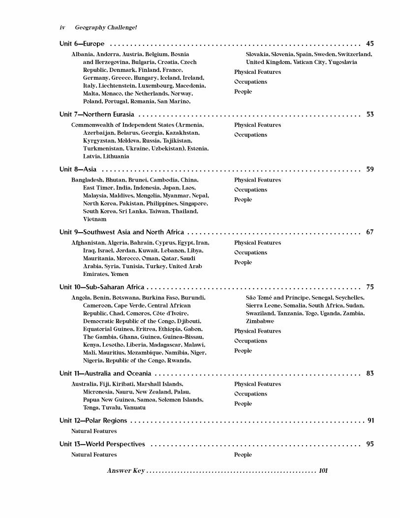
Unit 1—Geographical Terms and Understandings . . . . . . . . . . . . . . . . . . . . . . . . . . . . . . . . . . . . . . . 1
Maps
Land
Water
Climate and Weather
Soil and Vegetation
Unit 2—The United States . . . . . . . . . . . . . . . . . . . . . . . . . . . . . . . . . . . . . . . . . . . . . . . . . . . . . . . 13
Northeastern StatesConnecticut, Delaware, Maine, Maryland, Massachusetts, New Hampshire, New Jersey, New York, Pennsylvania, Rhode Island, Vermont
North Central StatesIllinois, Indiana, Iowa, Kansas, Michigan, Minnesota, Missouri, Nebraska, North Dakota, Ohio, South Dakota, Wisconsin
Southern StatesAlabama, Arkansas, Florida, Georgia, Kentucky, Louisiana, Mississippi, North Carolina, Oklahoma, South Carolina, Tennessee, Texas, Virginia, West Virginia
Western StatesAlaska, Arizona, California, Colorado, Hawaii, Idaho, Montana, Nevada, New Mexico, Oregon, Utah, Washington, Wyoming
Unit 3—Canada . . . . . . . . . . . . . . . . . . . . . . . . . . . . . . . . . . . . . . . . . . . . . . . . . . . . . . . . . . . . . . 23
Physical Features Occupations
Unit 4—Middle America and the Caribbean . . . . . . . . . . . . . . . . . . . . . . . . . . . . . . . . . . . . . . . . . 29
Antigua and Barbuda, the Bahamas, Barbados, Belize, Costa Rica, Cuba, Dominica, Dominican Republic, El Salvador, Grenada, Guatemala, Haiti, Honduras, Jamaica, Mexico, Nicaragua, Panama, St. Kitts and Nevis, St. Lucia, St. Vincent and the Grenadines, Trinidad and Tobago
Physical Features
Occupations
People
Unit 5—South America . . . . . . . . . . . . . . . . . . . . . . . . . . . . . . . . . . . . . . . . . . . . . . . . . . . . . . . . 37
Argentina, Bolivia, Brazil, Chile, Colombia, Ecuador, Guyana, Paraguay, Peru, Suriname, Uruguay, Venezuela
Physical Features
Occupations
People
iv Geography Challenge!
Unit 6—Europe . . . . . . . . . . . . . . . . . . . . . . . . . . . . . . . . . . . . . . . . . . . . . . . . . . . . . . . . . . . . . . 45
Albania, Andorra, Austria, Belgium, Bosnia and Herzegovina, Bulgaria, Croatia, Czech Republic, Denmark, Finland, France, Germany, Greece, Hungary, Iceland, Ireland, Italy, Liechtenstein, Luxembourg, Macedonia, Malta, Monaco, the Netherlands, Norway, Poland, Portugal, Romania, San Marino,
Slovakia, Slovenia, Spain, Sweden, Switzerland, United Kingdom, Vatican City, Yugoslavia
Physical Features
Occupations
People
Unit 7—Northern Eurasia . . . . . . . . . . . . . . . . . . . . . . . . . . . . . . . . . . . . . . . . . . . . . . . . . . . . . . . 53
Commonwealth of Independent States (Armenia, Azerbaijan, Belarus, Georgia, Kazakhstan, Kyrgyzstan, Moldova, Russia, Tajikistan, Turkmenistan, Ukraine, Uzbekistan), Estonia, Latvia, Lithuania
Physical Features
Occupations
Unit 8—Asia . . . . . . . . . . . . . . . . . . . . . . . . . . . . . . . . . . . . . . . . . . . . . . . . . . . . . . . . . . . . . . . . 59
Bangladesh, Bhutan, Brunei, Cambodia, China, East Timor, India, Indonesia, Japan, Laos, Malaysia, Maldives, Mongolia, Myanmar, Nepal, North Korea, Pakistan, Philippines, Singapore, South Korea, Sri Lanka, Taiwan, Thailand, Vietnam
Physical Features
Occupations
People
Unit 9—Southwest Asia and North Africa . . . . . . . . . . . . . . . . . . . . . . . . . . . . . . . . . . . . . . . . . . . 67
Afghanistan, Algeria, Bahrain, Cyprus, Egypt, Iran, Iraq, Israel, Jordan, Kuwait, Lebanon, Libya, Mauritania, Morocco, Oman, Qatar, Saudi Arabia, Syria, Tunisia, Turkey, United Arab Emirates, Yemen
Physical Features
Occupations
People
Unit 10—Sub-Saharan Africa . . . . . . . . . . . . . . . . . . . . . . . . . . . . . . . . . . . . . . . . . . . . . . . . . . . . . 75
Angola, Benin, Botswana, Burkina Faso, Burundi, Cameroon, Cape Verde, Central African Republic, Chad, Comoros, Côte d’Ivoire, Democratic Republic of the Congo, Djibouti, Equatorial Guinea, Eritrea, Ethiopia, Gabon, The Gambia, Ghana, Guinea, Guinea-Bissau, Kenya, Lesotho, Liberia, Madagascar, Malawi, Mali, Mauritius, Mozambique, Namibia, Niger, Nigeria, Republic of the Congo, Rwanda,
São Tomé and Príncipe, Senegal, Seychelles, Sierra Leone, Somalia, South Africa, Sudan, Swaziland, Tanzania, Togo, Uganda, Zambia, Zimbabwe
Physical Features
Occupations
People
Unit 11—Australia and Oceania . . . . . . . . . . . . . . . . . . . . . . . . . . . . . . . . . . . . . . . . . . . . . . . . . . . 83
Australia, Fiji, Kiribati, Marshall Islands, Micronesia, Nauru, New Zealand, Palau, Papua New Guinea, Samoa, Solomon Islands, Tonga, Tuvalu, Vanuatu
Physical Features
Occupations
People
Unit 12—Polar Regions . . . . . . . . . . . . . . . . . . . . . . . . . . . . . . . . . . . . . . . . . . . . . . . . . . . . . . . . . . 91
Natural Features
Unit 13—World Perspectives . . . . . . . . . . . . . . . . . . . . . . . . . . . . . . . . . . . . . . . . . . . . . . . . . . . . 95
Natural Features People
Answer Key . . . . . . . . . . . . . . . . . . . . . . . . . . . . . . . . . . . . . . . . . . . . . . . . . . . . . . . 101
UNIT 1UNIT 1
Geographical
Terms and
Understandings
2
Geograp
hy C
hallen
ge!
©1983, 1995, 2002 W
alch P
ublishin
g
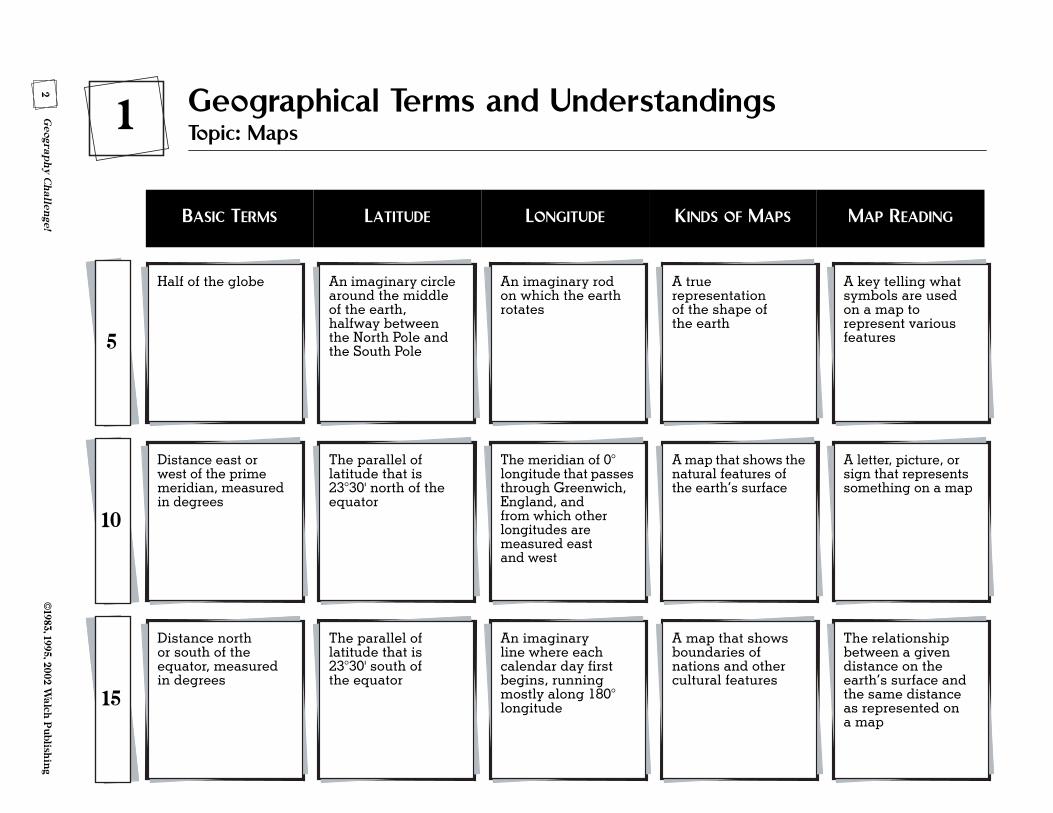
Half of the globe
5
1 Geographical Terms and UnderstandingsTopic: Maps
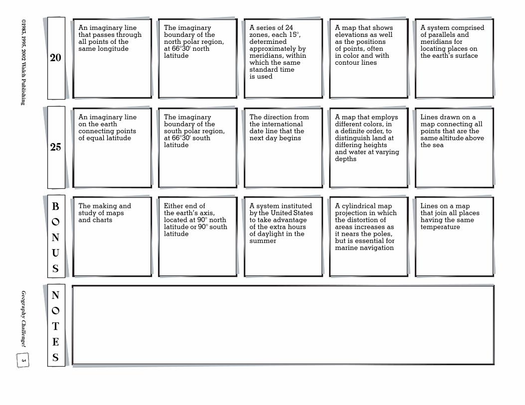
An imaginary circle around the middle of the earth, halfway between the North Pole and the South Pole
An imaginary rod on which the earth rotates
A true representation of the shape of the earth
A key telling what symbols are used on a map to represent various features
Distance east or west of the prime meridian, measured in degrees
10
The parallel of latitude that is 23°30' north of the equator
The meridian of 0° longitude that passes through Greenwich, England, and from which other longitudes are measured east and west
A map that shows the natural features of the earth’s surface
A letter, picture, or sign that represents something on a map
Distance north or south of the equator, measured in degrees
15
The parallel of latitude that is 23°30' south of the equator
An imaginary line where each calendar day first begins, running mostly along 180° longitude
A map that shows boundaries of nations and other cultural features
The relationship between a given distance on the earth’s surface and the same distance as represented on a map
BASIC TERMS LATITUDE LONGITUDE KINDS OF MAPS MAP READING
3©
1983, 1995, 2002 Walch
Publish
ing
Geograp
hy C
hallen
ge!
An imaginary line on the earth connecting points of equal latitude
25
The imaginary boundary of the south polar region, at 66°30' south latitude
The direction from the international date line that the next day begins
A map that employs different colors, in a definite order, to distinguish land at differing heights and water at varying depths
Lines drawn on a map connecting all points that are the same altitude above the sea
The making and study of maps and charts
B
O
N
U
S
Either end of the earth’s axis, located at 90° north latitude or 90° south latitude
A system instituted by the United States to take advantage of the extra hours of daylight in the summer
A cylindrical map projection in which the distortion of areas increases as it nears the poles, but is essential for marine navigation
Lines on a map that join all places having the same temperature
N
O
T
E
S
An imaginary line that passes through all points of the same longitude
20
The imaginary boundary of the north polar region, at 66°30' north latitude
A series of 24 zones, each 15°, determined approximately by meridians, within which the same standard time is used
A map that shows elevations as well as the positions of points, often in color and with contour lines
A system comprised of parallels and meridians for locating places on the earth’s surface
UNIT 2UNIT 2
The United States
16G
eograph
y Ch
allenge!
©1983, 1995, 2002 W
alch P
ublishin
g
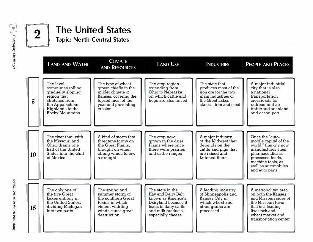
The level, sometimes rolling, gradually sloping region that stretches from the Appalachian Highlands to the Rocky Mountains
5
2 The United StatesTopic: North Central States
The type of wheat grown chiefly in the milder climate of Kansas, covering the topsoil most of the year and preventing erosion
The crop region extending from Ohio to Nebraska on which cattle and hogs are also raised
The state that produces most of the iron ore for the two main industries of the Great Lakes states—iron and steel
A major industrial city that is also a national transportation crossroads for railroad and air traffic and an inland and ocean port
The river that, with the Missouri and Ohio, drains one half of the United States into the Gulf of Mexico10
A kind of storm that threatens farms on the Great Plains, brought on when strong winds follow a drought
The crop now grown in the drier Plains where once there were prairies and cattle ranges
A major industry of the Midwest that depends on the cattle and pigs that are raised and fattened there
Once the “auto- mobile capital of the world,” this city now manufactures steel, pharmaceuticals, processed foods, machine tools, as well as automobiles and auto parts.
The only one of the five Great Lakes entirely in the United States, dividing Michigan into two parts15
The spring and summer storm of the southern Great Plains in which violent whirling winds cause great destruction
The state in the Hay and Dairy Belt known as America’s Dairyland because it leads in dairy cattle and milk products, especially cheese
A leading industry of Minneapolis and Kansas City in which wheat and other grains are processed
A metropolitan area on both the Kansas and Missouri sides of the Missouri River that is a leading livestock and wheat market and transportation center
LAND AND WATERCLIMATE
AND RESOURCESLAND USE INDUSTRIES PEOPLE AND PLACES
17©
1983, 1995, 2002 Walch
Publish
ing
Geograp
hy C
hallen
ge!
The waterway that links much of the Midwest, via the Great Lakes, with ocean trade routes25
The two leading corn states that have some of the most valuable farmland in the United States
Another crop grown in the Corn Belt as feed for livestock and as a source for oil, flour, and other products
A highly- industrialized city in northeastern Ohio, still an important center of rubber research and development
The chief port on Lake Erie within easy reach of raw materials and markets that manufactures steel and steel products
Low mountains in South Dakota that eroded into gigantic rock stubs and became the site of the Mount Rushmore Memorial and a large gold mine
B
O
N
U
S
The natural force that leveled the Plains area and left behind deep, rich, black soil
Organizations of several small farmers in which the costs and profits of farm production are shared
The Kansas city and its surrounding area known for the manufacture of aircraft and aircraft parts
A lake port and industrial city specializing in farm machinery, engineering, and breweries
N
O
T
E
S
The main tributary of the Mississippi River, upon which dams were built for flood control, irrigation, and navigability
20
The fossil fuel abundant in Illinois which is used to generate about half the state’s electricity
Bins in which wheat is stored until it is shipped to market
One of the greatest concentrations of heavy industry in the United States, located in the vast urban area in Indiana that borders Lake Michigan
The Gateway Arch to the West, a major transportation center due to its location, and a leader in the chemical, auto parts, and food-processing industries
UNIT 3UNIT 3
Canada
24G
eograph
y Ch
allenge!
©1983, 1995, 2002 W
alch P
ublishin
g
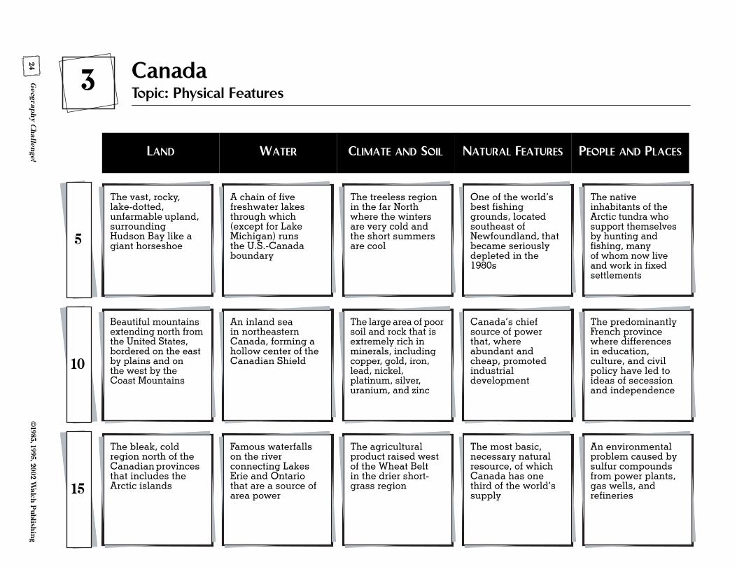
The vast, rocky, lake-dotted, unfarmable upland, surrounding Hudson Bay like a giant horseshoe5
3 CanadaTopic: Physical Features
A chain of five freshwater lakes through which (except for Lake Michigan) runs the U.S.-Canada boundary
The treeless region in the far North where the winters are very cold and the short summers are cool
One of the world’s best fishing grounds, located southeast of Newfoundland, that became seriously depleted in the 1980s
The native inhabitants of the Arctic tundra who support themselves by hunting and fishing, many of whom now live and work in fixed settlements
Beautiful mountains extending north from the United States, bordered on the east by plains and on the west by the Coast Mountains
10
An inland sea in northeastern Canada, forming a hollow center of the Canadian Shield
The large area of poor soil and rock that is extremely rich in minerals, including copper, gold, iron, lead, nickel, platinum, silver, uranium, and zinc
Canada’s chief source of power that, where abundant and cheap, promoted industrial development
The predominantly French province where differences in education, culture, and civil policy have led to ideas of secession and independence
The bleak, cold region north of the Canadian provinces that includes the Arctic islands15
Famous waterfalls on the river connecting Lakes Erie and Ontario that are a source of area power
The agricultural product raised west of the Wheat Belt in the drier short-grass region
The most basic, necessary natural resource, of which Canada has one third of the world’s supply
An environmental problem caused by sulfur compounds from power plants, gas wells, and refineries
LAND WATER CLIMATE AND SOIL NATURAL FEATURES PEOPLE AND PLACES
25©
1983, 1995, 2002 Walch
Publish
ing
Geograp
hy C
hallen
ge!
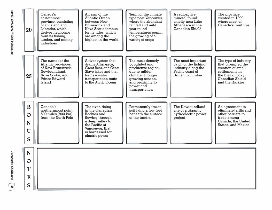
The name for the Atlantic provinces of New Brunswick, Newfoundland, Nova Scotia, and Prince Edward Island
25
A river system that drains Athabasca, Great Bear, and Great Slave lakes and that forms a water transportation route to the Arctic Ocean
The most densely populated and productive region, due to milder climate, a longer growing season, and proximity to power and transportation
The most important catch of the fishing industry along the Pacific coast of British Columbia
The type of industry that prompted the creation of small settlements in the bleak, rocky Canadian Shield and the Rockies
Canada’s northernmost point, 500 miles (800 km) from the North Pole
B
O
N
U
S
The river, rising in the Canadian Rockies and flowing through a deep valley to the Pacific at Vancouver, that is harnessed for electric power
Permanently frozen soil lying a few feet beneath the surface of the tundra
The Newfoundland site of a gigantic hydroelectric power project
An agreement to eliminate tariffs and other barriers to trade among Canada, the United States, and Mexico
N
O
T
E
S
Canada’s easternmost province, consisting of an island and Labrador, which derives its income from its fishing, lumber, and mining industries
20
An arm of the Atlantic Ocean between New Brunswick and Nova Scotia famous for its tides, which are among the highest in the world
Term for the climate type near Vancouver, where the abundant rainfall and mild year-round temperatures permit the growing of a variety of crops
A radioactive mineral found chiefly near Lake Athabasca in the Canadian Shield
The province created in 1999 where most of Canada’s Inuit live

UNIT 5UNIT 5
South America
38G
eograph
y Ch
allenge!
©1983, 1995, 2002 W
alch P
ublishin
g
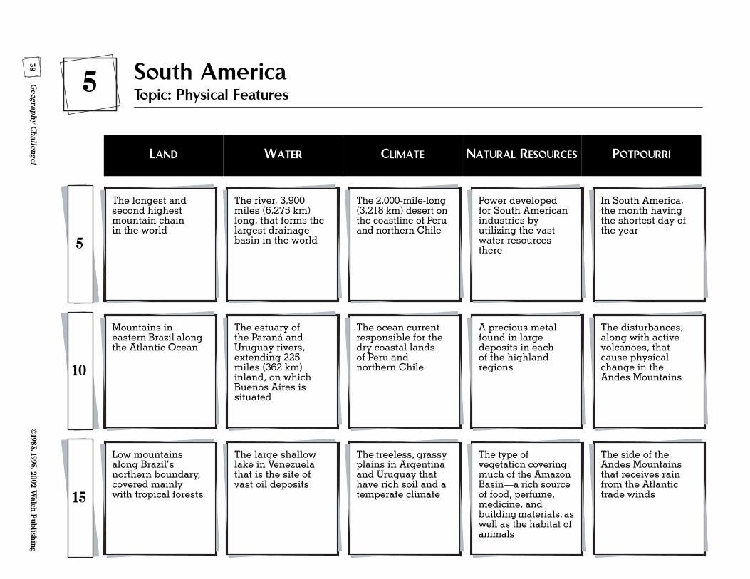
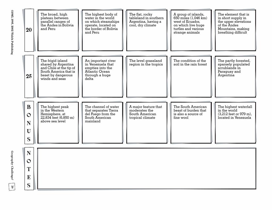
The longest and second highest mountain chain in the world
5
5 South AmericaTopic: Physical Features
The river, 3,900 miles (6,275 km) long, that forms the largest drainage basin in the world
The 2,000-mile-long (3,218 km) desert on the coastline of Peru and northern Chile
Power developed for South American industries by utilizing the vast water resources there
In South America, the month having the shortest day of the year
Mountains in eastern Brazil along the Atlantic Ocean
10
The estuary of the Paraná and Uruguay rivers, extending 225 miles (362 km) inland, on which Buenos Aires is situated
The ocean current responsible for the dry coastal lands of Peru and northern Chile
A precious metal found in large deposits in each of the highland regions
The disturbances, along with active volcanoes, that cause physical change in the Andes Mountains
Low mountains along Brazil’s northern boundary, covered mainly with tropical forests15
The large shallow lake in Venezuela that is the site of vast oil deposits
The treeless, grassy plains in Argentina and Uruguay that have rich soil and a temperate climate
The type of vegetation covering much of the Amazon Basin—a rich source of food, perfume, medicine, and building materials, as well as the habitat of animals
The side of the Andes Mountains that receives rain from the Atlantic trade winds
LAND WATER CLIMATE NATURAL RESOURCES POTPOURRI
39©
1983, 1995, 2002 Walch
Publish
ing
Geograp
hy C
hallen
ge!
The frigid island shared by Argentina and Chile at the tip of South America that is beset by dangerous winds and seas25
An important river in Venezuela that empties into the Atlantic Ocean through a huge delta
The level grassland region in the tropics
The condition of the soil in the rain forest
The partly forested, sparsely populated scrublands in Paraguay and Argentina
The highest peak in the Western Hemisphere, at 22,834 feet (6,850 m) above sea level
B
O
N
U
S
The channel of water that separates Tierra del Fuego from the South American mainland
A major feature that moderates the South American tropical climate
The South American beast of burden that is also a source of fine wool
The highest waterfall in the world (3,212 feet or 979 m), located in Venezuela
N
O
T
E
S
The broad, high plateau between parallel ranges of the Andes in Bolivia and Peru20
The highest body of water in the world on which steamships operate, located on the border of Bolivia and Peru
The flat, rocky tableland in southern Argentina, having a cool, dry climate
A group of islands, 650 miles (1,046 km) west of Ecuador, on which live huge turtles and various strange animals
The element that is in short supply in the upper elevations of the Andes Mountains, making breathing difficult

UNIT 8UNIT 8
Asia
60G
eograph
y Ch
allenge!
©1983, 1995, 2002 W
alch P
ublishin
g
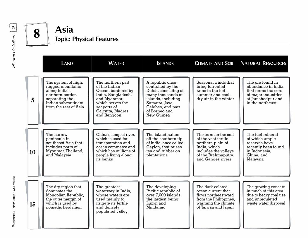
The system of high, rugged mountains along India’s northern border, separating the Indian subcontinent from the rest of Asia
5
8 AsiaTopic: Physical Features
The northern part of the Indian Ocean, bordered by India, Bangladesh, and Myanmar, which serves the seaports of Calcutta, Madras, and Rangoon
A republic once controlled by the Dutch, consisting of many thousands of islands, including Sumatra, Java, Celebes, and part of Borneo and New Guinea
Seasonal winds that bring torrential rains in the hot summer and cool, dry air in the winter
The ore found in abundance in India that forms the core of major industries at Jamshedpur and in the northeast
The narrow peninsula in southeast Asia that includes parts of Myanmar, Thailand, and Malaysia10
China’s longest river, which is used for transportation and ocean commerce and which has millions of people living along its banks
The island nation off the southern tip of India, once called Ceylon, that raises tea and rubber on plantations
The term for the soil of the vast fertile northern plain of India, which includes the valleys of the Brahmaputra and Ganges rivers
The fuel mineral of which ample reserves have recently been found in Indonesia, China, and Malaysia
The dry region that dominates the Mongolian Republic, the outer margin of which is used by nomadic herdsmen15
The greatest waterway in India, whose waters are used mainly to irrigate its fertile and densely populated valley
The developing Pacific republic of over 7,000 islands, the largest being Luzon and Mindanao
The dark-colored ocean current that flows northeastward from the Philippines, warming the climate of Taiwan and Japan
The growing concern in much of this area due to heavy coal use and unregulated waste water disposal
LAND WATER ISLANDS CLIMATE AND SOIL NATURAL RESOURCES
61©
1983, 1995, 2002 Walch
Publish
ing
Geograp
hy C
hallen
ge!
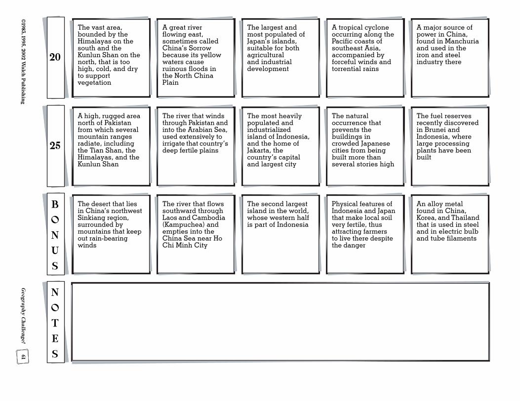
A high, rugged area north of Pakistan from which several mountain ranges radiate, including the Tian Shan, the Himalayas, and the Kunlun Shan
25
The river that winds through Pakistan and into the Arabian Sea, used extensively to irrigate that country’s deep fertile plains
The most heavily populated and industrialized island of Indonesia, and the home of Jakarta, the country’s capital and largest city
The natural occurrence that prevents the buildings in crowded Japanese cities from being built more than several stories high
The fuel reserves recently discovered in Brunei and Indonesia, where large processing plants have been built
The desert that lies in China’s northwest Sinkiang region, surrounded by mountains that keep out rain-bearing winds
B
O
N
U
S
The river that flows southward through Laos and Cambodia (Kampuchea) and empties into the China Sea near Ho Chi Minh City
The second largest island in the world, whose western half is part of Indonesia
Physical features of Indonesia and Japan that make local soil very fertile, thus attracting farmers to live there despite the danger
An alloy metal found in China, Korea, and Thailand that is used in steel and in electric bulb and tube filaments
N
O
T
E
S
The vast area, bounded by the Himalayas on the south and the Kunlun Shan on the north, that is too high, cold, and dry to support vegetation
20
A great river flowing east, sometimes called China’s Sorrow because its yellow waters cause ruinous floods in the North China Plain
The largest and most populated of Japan’s islands, suitable for both agricultural and industrial development
A tropical cyclone occurring along the Pacific coasts of southeast Asia, accompanied by forceful winds and torrential rains
A major source of power in China, found in Manchuria and used in the iron and steel industry there
UNIT 9UNIT 9
Southwest Asia
and North Africa
68G
eograph
y Ch
allenge!
©1983, 1995, 2002 W
alch P
ublishin
g
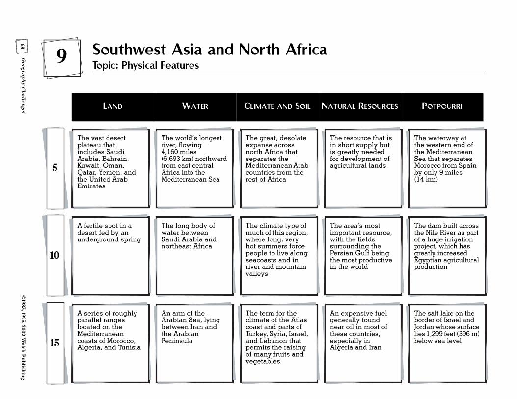
The vast desert plateau that includes Saudi Arabia, Bahrain, Kuwait, Oman, Qatar, Yemen, and the United Arab Emirates
5
9 Southwest Asia and North AfricaTopic: Physical Features
The world’s longest river, flowing 4,160 miles (6,693 km) northward from east central Africa into the Mediterranean Sea
The great, desolate expanse across north Africa that separates the Mediterranean Arab countries from the rest of Africa
The resource that is in short supply but is greatly needed for development of agricultural lands
The waterway at the western end of the Mediterranean Sea that separates Morocco from Spain by only 9 miles (14 km)
A fertile spot in a desert fed by an underground spring
10
The long body of water between Saudi Arabia and northeast Africa
The climate type of much of this region, where long, very hot summers force people to live along seacoasts and in river and mountain valleys
The area’s most important resource, with the fields surrounding the Persian Gulf being the most productive in the world
The dam built across the Nile River as part of a huge irrigation project, which has greatly increased Egyptian agricultural production
A series of roughly parallel ranges located on the Mediterranean coasts of Morocco, Algeria, and Tunisia15
An arm of the Arabian Sea, lying between Iran and the Arabian Peninsula
The term for the climate of the Atlas coast and parts of Turkey, Syria, Israel, and Lebanon that permits the raising of many fruits and vegetables
An expensive fuel generally found near oil in most of these countries, especially in Algeria and Iran
The salt lake on the border of Israel and Jordan whose surface lies 1,299 feet (396 m) below sea level
LAND WATER CLIMATE AND SOIL NATURAL RESOURCES POTPOURRI
69©
1983, 1995, 2002 Walch
Publish
ing
Geograp
hy C
hallen
ge!
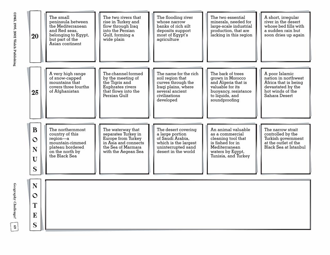
A very high range of snow-capped mountains that covers three fourths of Afghanistan25
The channel formed by the meeting of the Tigris and Euphrates rivers that flows into the Persian Gulf
The name for the rich soil region that curves through the Iraqi plains, where several ancient civilizations developed
The bark of trees grown in Morocco and Algeria that is valuable for its buoyancy, resistance to liquids, and soundproofing
A poor Islamic nation in northwest Africa that is being devastated by the hot winds of the Sahara Desert
The northernmost country of this region—a mountain-rimmed plateau bordered on the north by the Black Sea
B
O
N
U
S
The waterway that separates Turkey in Europe from Turkey in Asia and connects the Sea of Marmara with the Aegean Sea
The desert covering a large portion of Saudi Arabia, which is the largest uninterrupted sand desert in the world
An animal valuable as a commercial cleaning tool that is fished for in Mediterranean waters by Egypt, Tunisia, and Turkey
The narrow strait controlled by the Turkish government at the outlet of the Black Sea at Istanbul
N
O
T
E
S
The small peninsula between the Mediterranean and Red seas, belonging to Egypt, but part of the Asian continent
20
The two rivers that rise in Turkey and flow through Iraq into the Persian Gulf, forming a wide plain
The flooding river whose narrow banks of rich silt deposits support most of Egypt’s agriculture
The two essential minerals, needed for large-scale industrial production, that are lacking in this region
A short, irregular river in the desert whose bed fills with a sudden rain but soon dries up again