Embed Size (px)
Citation preview

CONTAMINATION TECHNICAL MEMORANDUM – PREFERRED POND SITES
Florida Turnpike Enterprise
Central Polk Parkway Extension PD&E Study From SR 35 (US 17) to SR 60
Polk County, Florida
Financial Management Number: 440897-4-24-01
November 20, 2020
DRAFT

Contamination Tech Memo – Pond Alternatives Central Polk Parkway Extension PD&E Study
November 20, 2020 Page i FPID No. 440897-4-24-01
TABLE OF CONTENTS
SECTION Page
1.0 Introduction .................................................................................................... 1
1.1 Purpose ........................................................................................................................1
2.0 Methodology ................................................................................................... 1
3.0 Contamination Screening Evaluation .......................................................... 4
3.1 SMF 1B .......................................................................................................................4
3.2 SMF 2B .......................................................................................................................5
3.3 SMF 3B .......................................................................................................................6
3.4 SMF 4B1 .....................................................................................................................7
3.5 SMF 4B2 .....................................................................................................................9
3.6 FPC 1B ......................................................................................................................10
3.7 FPC 2A......................................................................................................................11
3.8 FPC 3A......................................................................................................................12
3.9 FPC 4B ......................................................................................................................13
4.0 Summary ......................................................................................................14
Appendix: Appendix A -- Aerial Photograph with Preferred Pond Sites Appendix B – Environmental Data Management Report
DRAFT

Contamination Tech Memo – Preferred Pond Sites Central Polk Parkway Extension PD&E Study
November 20, 2020 1 FPID No. 440897-4-24-01
1.0 Introduction
The Central Polk Parkway (CPP/SR 570B) will be a new four-lane divided limited access facility
in Polk County, Florida. Through coordination with Florida’s Turnpike Enterprise it has been
determined that this new corridor will be a Strategic Intermodal System (SIS) highway (see Project
Area Map attached). This roadway network is a planned new alignment toll facility that will
connect the Polk Parkway (SR 570) with SR 60 to the south. The project is located between the
City of Lakeland to the north and the City of Bartow to the west and will be completed with
multiple Financial Project Identification (FPID) Numbers. This Tech Memo has been revised based
on comments provided (on November 17, 2019) by Mr. Eric Krebill, DCIC, and Philip Stein, EMO
Manager, Florida Turnpike Enterprise (FTE) and a conference call between FTE representatives
and Mr. Michael Bair, Chief Scientist, Tierra on November 25, 2019. Then, this report was revised
based on FTE comments received on February 17, 2020. Tierra’s responses to FTE comments
were accepted by FTE on February 19, 2020.
This report revision includes a preliminary evaluation of the nine preferred Flood Plain
Compensation (FPC) areas, and Stormwater Management Facilities (SMFs) provided by the client
on November 9, 2020.
1.1 Purpose
The purpose of this Contamination Technical Memorandum (Tech Memo) is to identify
contamination sites within or adjacent to the preferred FPCs/SMFs and provide preliminary risk
ratings for the preferred FPCs/SMFs. Contamination can have a significant negative impact on the
project and therefore the early identification of any contamination involvement will provide
valuable input during the evaluation process.
2.0 Methodology
This Tech Memo was developed as an abbreviated contamination study as part of the PD&E. The
effort at this stage of the project was not intended to satisfy all of the requirements as referenced
in the PD&E Manual: Part 2, Chapter 20 Contamination. Instead, the level of effort was designed
to provide planning level data to support the Pond Siting Report.
To assist with accomplishing the project objectives, an environmental data report was prepared on
September 23, 2019 by Environmental Data Management, Inc. (EDM) to identify sites within ⅛-
mile and ½ mile of the mainline that are associated with documented contamination issues from
petroleum products or other hazardous materials. The EDM report has been utilized as a
preliminary screening tool to identify facilities that have reported contamination issues to various
county, state, and federal agencies.
DRAFT
Contamination Tech Memo – Preferred Pond Sites Central Polk Parkway Extension PD&E Study
November 20, 2020 2 FPID No. 440897-4-24-01
The information presented in the EDM report was then analyzed to provide a preliminary
contamination risk rating for each FPC/SMF. It should be noted that supplemental regulatory
research (OCULUS, Map Direct, STCM, etc.) was not performed, nor were site visits or other
desktop literature reviews.
A limited review of historic aerial photographs was performed using Google Earth imagery from
1994 to the most current aerial photograph available. Historic aerial photographs are included in
Section 3.0.
The risk ratings presented herein should be viewed as preliminary, with the understanding that
they might receive a revised rating with the benefit of additional research and review. It is
anticipated that the complete contamination evaluation, including all the study elements in
accordance with the PD&E Manual: Part 2, Chapter 20 Contamination, will be performed for all
final FPCs/SMFs during the Design Phase of this project. Further level of detail will be provided
for each FPC/SMF during that time.
Contamination risk ratings were assigned to each FPC/SMF. The rating system is divided into four
categories of risk as defined by the FDOT in the PD&E Manual: Part 2, Chapter 20
Contamination. These four degrees of risk are “No,” “Low,” “Medium,” and “High.” This system
expresses the degree of concern for potential contamination problems and is summarized below.
No Risk Rating
A review of available information on the property and a review of the conceptual or design plans
indicates there is no potential contamination impact to the project. It is possible that contaminants
have been handled on the property. However, findings from the Level I evaluation indicate that
contamination impacts are not expected.
Low Risk Rating
A review of available information indicates that past or current activities on the property have an
ongoing contamination issue; the site has a hazardous waste generator identification (ID) number,
or the site stores, handles, or manufactures hazardous materials. However, based on the review of
conceptual or design plans and/or findings from the Level I evaluation, it is not likely that there
would be any contamination impacts to the project.
Medium Risk Rating
After a review of conceptual or design plans and findings from a Level I evaluation, a potential
contamination impact to the project has been identified. If there is insufficient information (such
as regulatory records or site historical documents) to make a determination as to the potential for
contamination impact, and there is reasonable suspicion that contamination may exist, the property
should be rated at least as a “Medium”. Properties used historically as gasoline stations and which
DRAFT

Contamination Tech Memo – Preferred Pond Sites Central Polk Parkway Extension PD&E Study
November 20, 2020 3 FPID No. 440897-4-24-01
have not been evaluated or assessed by regulatory agencies, sites with abandoned in place
underground petroleum storage tanks or currently operating gasoline stations should receive this
rating.
High Risk Rating
After a review of all available information and conceptual or design plans, there is appropriate
analytical data that shows contamination will substantially impact construction activities, have
implications to ROW acquisition or have other potential transfer of contamination related liability
to the FDOT.
DRAFT

Contamination Tech Memo – Preferred Pond Sites Central Polk Parkway Extension PD&E Study
November 20, 2020 4 FPID No. 440897-4-24-01
3.0 Contamination Screening Evaluation
It is important to note, much of this vicinity was historically used for phosphate mining (see
topographic maps, historic aerial photographs, etc. as provided in Tierra’s Level I Contamination
Screening Evaluation Report (mainline) dated November 11, 2019 (and subsequent updates)).
Contamination related regulatory records were not identified for this former mining (only
reclamation).
Specific details for each preferred FPC/SMF are provided below.
3.1 SMF 1B
EDM’s report identifies Tyre Equipment (equipment rental/maintenance) on the TANKS
(petroleum storage tanks) database listing. EDM’s report states this facility has two ASTs: one
550-gallon diesel, and one 250-gallon unleaded gasoline. No discharges were reported. The tank
farm is located approximately 200 feet east of SMF 1B.
Historic aerial photographs depict 1st Street, approximately eight structures, several small sheds,
pasture, trails, and earthwork onsite between 1994 and 2018.
Google Earth imagery dated 12/2006
Based on the historic use for phosphate mining, SMF 1B is assigned an initial risk rating of
Medium.
DRAFT

Contamination Tech Memo – Preferred Pond Sites Central Polk Parkway Extension PD&E Study
November 20, 2020 5 FPID No. 440897-4-24-01
3.2 SMF 2B
EDM’s report identified no sites within ½ mile of this pond.
Historic aerial photographs depict pasture, earthwork (reclamation), and a haul road onsite
between 1994 and 2018.
Google Earth imagery dated 1/1999
Based on the historic use for phosphate mining, SMF 2B is assigned an initial risk rating of
Medium.
DRAFT

Contamination Tech Memo – Preferred Pond Sites Central Polk Parkway Extension PD&E Study
November 20, 2020 6 FPID No. 440897-4-24-01
3.3 SMF 3B
EDM’s report identified no sites within ½ mile of this pond.
Historic aerial photographs depict pasture, woods, earthwork (reclamation), and a haul road onsite
between 1994 and 2018.
Google Earth imagery dated 12/2018
Based on the historic use for phosphate mining, SMF 3B is assigned an initial risk rating of
Medium.
DRAFT

Contamination Tech Memo – Preferred Pond Sites Central Polk Parkway Extension PD&E Study
November 20, 2020 7 FPID No. 440897-4-24-01
3.4 SMF 4B1
The southeast corner of this pond alternative is depicted within an Ethylene Dibromide (EDB)
groundwater contamination zone found on EDM’s Environmental Impact Areas Map (CSER
Appendix D) and FDEP MapDirect database. According to information obtained from the FDEP
Delineation database (http://www.dep.state.fl.us/water/groundwater/delineate.htm), from 1962 to
mid-1983, the Florida Department of Agriculture and Consumer Services conducted widespread
field application of a soil fumigant, ethylene dibromide (EDB or Dibromoethane 1,2-), to control
nematodes in citrus groves. EDB was also used by private citizens on golf courses and on crops
such as peanuts and soybeans. The extent of contamination is estimated by the FDEP using a geo-
statistical tool called variogram analysis. Where data is incomplete, a 1000-foot protective setback
is placed around the contaminated site or well to estimate the extent of the contaminated plume.
Additionally, the FDEP has delineated areas of Florida where EDB was historically applied but
for which little or no ground water quality data exist. The latest maps produced by the FDEP were
approved in 1994. The density of EDB is greater than that of water and therefore sinks through the
water column until impeded by an impermeable soil stratum. The Project Development and
Environment (PD&E) Final Geotechnical Report dated March 5, 2020 states groundwater was not
encountered at the auger boring (AB-1438A1, depth of boring ten feet bls) located near the north
boundary of SMF 4B1 on February 27, 2019. No other borings were performed within SMF 4B1.
The pond bottom design depth is unknown at this time. Given this information, an opinion
concerning impact to groundwater cannot be tendered at this time. Due to the potential remnant
soil impacts from the application of EDB, this zone is considered a contamination concern to SMF
4B1.
Additionally, EDM’s report identified one ECHO database listing (Northeast Bartow Regional
Force Main, NPDES) within ⅛ mile of this pond.
Historic aerial photographs depict groves, pasture, woods, earthwork (reclamation), and a
powerline easement onsite between 1994 and 2018. Offsite, adjacent east was groves, 91 Mine
Road, and Florida Truck and Trailer (truck and trailer repair shop). Florida Truck and Trailer was
identified as a site in EDM’s report (proximal records) and is located approximately 70 feet east
of SMF 4B1. The EPA ECHO database listing is associated with an FDEP Warning Letter #123456
dated August 2, 1999. The warning letter was issued based on seven violations noted during an
FDEP hazardous waste site inspection performed on July 26, 1999. Violations noted were
administrative in nature (i.e. improper/no labels, manifests, failure to post spill control procedures
and emergency response contacts, failure to coordinate with local authorities for emergency
response, failure to inspect hazardous waste storage areas, etc.). Violations cited in the warning
letter were resolved and the case was closed according to the FDEP letter dated October 27, 1999.
The NONTSD database listing is for registration as a Small Quantity Generator (SQG) of
DRAFT

Contamination Tech Memo – Preferred Pond Sites Central Polk Parkway Extension PD&E Study
November 20, 2020 8 FPID No. 440897-4-24-01
hazardous wastes submitted in 1999. Given the lack of documented contamination, this facility is
considered a low risk to SMF 4B1.
Google Earth imagery dated 1/1999
Based on the historic use as groves and phosphate mining, and location within an EDB plume,
SMF 4B1 is assigned an initial risk rating of Medium.
DRAFT

Contamination Tech Memo – Preferred Pond Sites Central Polk Parkway Extension PD&E Study
November 20, 2020 9 FPID No. 440897-4-24-01
3.5 SMF 4B2
EDM’s report identified one ECHO database listing (Northeast Bartow Regional Force Main,
NPDES) within ⅛ mile of this pond.
Historic aerial photographs depict equipment staging/pipe stockpile areas (possibly associated
with force main installation in 2010), pasture, woods, and earthwork (reclamation) onsite between
1994 and 2018. Additionally, a holding pond (presumably water) was located near the northwest
corner in 2010.
Google Earth imagery dated 12/2010
Based on the historic use for phosphate mining, SMF 4B2 is assigned an initial risk rating of
Medium.
DRAFT

Contamination Tech Memo – Preferred Pond Sites Central Polk Parkway Extension PD&E Study
November 20, 2020 10 FPID No. 440897-4-24-01
3.6 FPC 1B
EDM’s report identified 1 regulatory listings onsite: Duratek (ECHO). Offsite, 2 adjacent listings
are located within ⅛ mile: Tyre Equipment rental facility (TANKS), and Scrap It III/Bartow
Salvage (ECHO/NONTSD).
Historic aerial photographs depict fields, woods, manmade ponds, a haul road, equipment/vehicle
storage/parking onsite between 1994 and 2018.
Google Earth imagery dated 12/2010
Based on the historic use as a portion of an industrial facility, FPC 1B is assigned an initial risk
rating of Medium.
DRAFT
Contamination Tech Memo – Preferred Pond Sites Central Polk Parkway Extension PD&E Study
November 20, 2020 11 FPID No. 440897-4-24-01
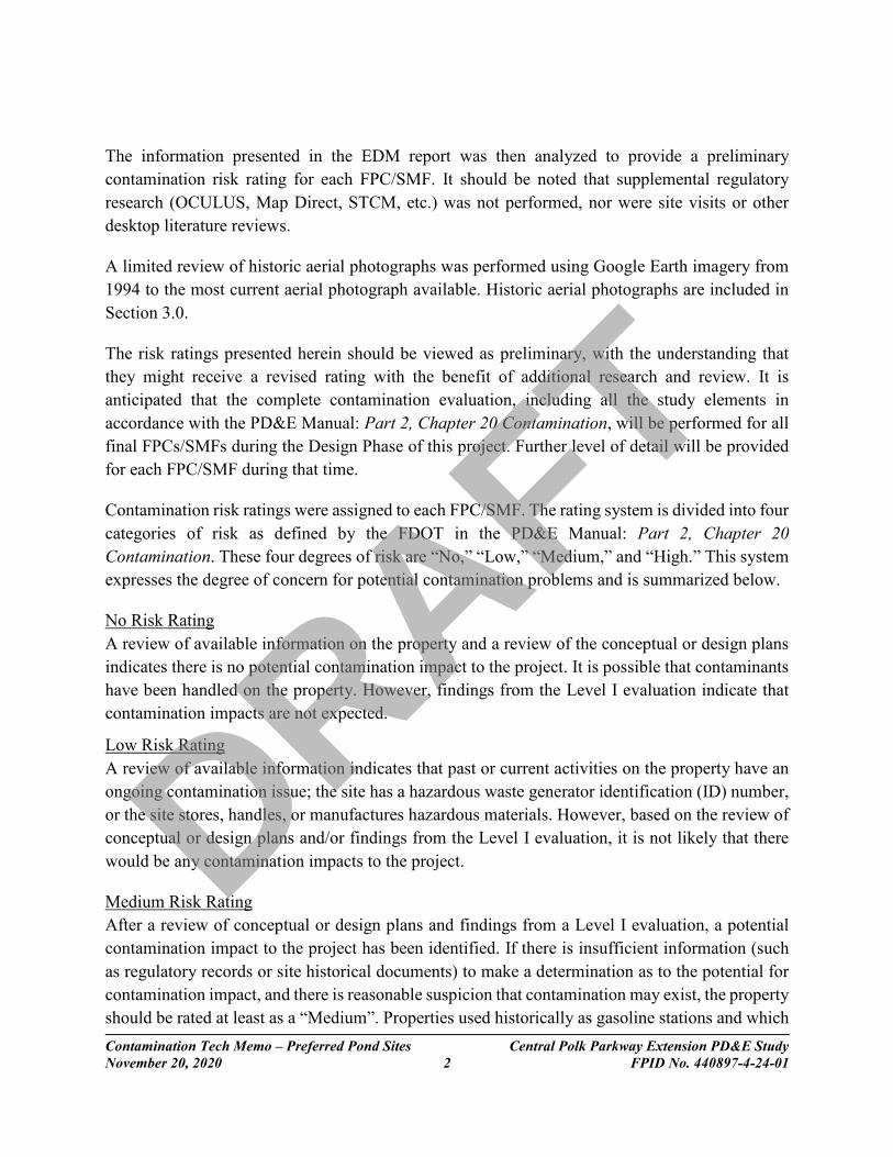
3.7 FPC 2A
EDM’s report identified no regulatory listings onsite. There are 3 listings located within ⅛ mile
and include Duratek (ECHO), Tyre Equipment (TANKS), and Scrap It III/Bartow Salvage
(ECHO/NONTSD).
Historic aerial photographs depict clearing/earthwork (possible mining), pond, haul roads/trails,
field, and woods onsite between 1994 and 2018.
Google Earth imagery dated 3/1994
Based on the unknown nature of earthwork onsite, FPC 2A is assigned an initial risk rating of Low.
DRAFT

Contamination Tech Memo – Preferred Pond Sites Central Polk Parkway Extension PD&E Study
November 20, 2020 12 FPID No. 440897-4-24-01
3.8 FPC 3A
EDM’s report identified no sites within ⅛ mile of this pond.
Historic aerial photographs depict a mine/earthwork, haul roads, 2 structures, and woods onsite
between 1994 and 2018.
Google Earth imagery dated 12/2018
Based on the historic use for mining, FPC 3A is assigned an initial risk rating of Medium.
DRAFT

Contamination Tech Memo – Preferred Pond Sites Central Polk Parkway Extension PD&E Study
November 20, 2020 13 FPID No. 440897-4-24-01
3.9 FPC 4B
EDM’s report identified no sites within ⅛ mile of this pond.
Historic aerial photographs depict pasture, woods, cattle pen, three structures, and trails onsite
between 1994 and 2018. The nature of structures located onsite is unknown.
Google Earth imagery dated 3/1994
Based on the unknown nature of structures located onsite, FPC 4B is assigned an initial risk rating
of Low.
DRAFT

Contamination Tech Memo – Preferred Pond Sites Central Polk Parkway Extension PD&E Study
November 20, 2020 14 FPID No. 440897-4-24-01
4.0 Summary
Tierra has reviewed the regulatory database report and aerial photographs (limited review) to
identify contamination sites associated with each of the preferred FPCs/SMFs. Risk ratings were
assigned to each FPC/SMF in accordance with the FDOT contamination rating system. A summary
of the risk ratings assigned to each FPC/SMF is provided below.
Risk Rating Summary – Preferred Pond Sites
High Medium Low No
0 7 2 0
This Tech Memo was developed as an abbreviated contamination study as part of the PD&E Study.
The level of effort performed for this phase of the project was designed to provide planning level
data to include with the Pond Siting Report.
Recommendations
Once final design plans are available, additional review is recommended in consideration of
dewatering operations that may be necessary under the National Pollutant Discharge Elimination
System (NPDES) Generic Permit for Stormwater Discharges from Large and Small Construction
Activities. Verification testing may be warranted for contamination issues within 500 feet of the
dewatering area.
Additional information may become available or site-specific conditions may change from the
time this report was prepared and should be considered prior to acquiring ROW and/or proceeding
with roadway construction.
The FPCs/SMFs assigned risk ratings of No and Low are not anticipated to impact project
construction at this time.
The FPCs/SMFs assigned risk ratings of Medium (none were rated High) are anticipated to impact
project construction. Therefore, Level II screening may be warranted for the preferred pond sites
selected for final design. A detailed Level II Scope of Services should be generated which includes
testing locations and analytical parameters. The Level II scope should be coordinated with the
District Contamination Impact Coordinator (DCIC).
Recommended analytical testing for SMFs/FPCs with Medium ratings (none were rated High)
may include the following:
DRAFT

Contamination Tech Memo – Preferred Pond Sites Central Polk Parkway Extension PD&E Study
November 20, 2020 15 FPID No. 440897-4-24-01
Laboratory Analytical Testing
Contaminants of
Concern SMFs/FPCs Parameters
Agriculture
(groves, crops)
metals,
herbicides,
pesticides
SMF 4B1
Arsenic by EPA Method 6010
Organochlorine Pesticides by EPA Method 8141
Organophosphorus Pesticides by EPA Method 8081
Herbicides by EPA Method 8151
EDB by EPA Method 8011
Mining
radium, pH,
petroleum
SMF 1B, 2B,
3B, 4B1 and
4B2; and
FPC 3A
Radium 226 by EPA Method
Polycyclic Aromatic Hydrocarbons (PAHs) by EPA
Method 8270
Total Petroleum Hydrocarbons (TPH) by FL PRO method
Volatile Organic Compounds (VOCs) EPA Method 8260
pH in situ
Industrial
Facility
(former precast
cement plant)
petroleum
FPC 1B
EPA Method 6010
PAHs by EPA Method 8270
TPH by FL PRO method
VOCs EPA Method 8260
*Note: Equivalent and/or similar EPA Methods may be substituted
A NESHAP Asbestos Survey may be warranted for structures, including cementitious buried
utility pipes, located within the limits of applicable preferred pond sites selected for final design.
DRAFT

Contamination Tech Memo – Pond Alternatives Central Polk Parkway Extension PD&E Study
November 20, 2020 FPID No. 440897-4-24-01
APPENDIX A
Aerial Photograph with Preferred Pond Sites
DRAFT

FPC 1B
SMF 1B
SMF 2B
FPC 2A
SMF 4B2
FPC 3A
SMF 4B1
SMF 3B
FPC 4B
SR 60
US 17
NINE
TY-ON
E MI N
ERD
µPond Location Map
Path: D:\Projects\M\1201739.00_CPP\NonSubmittalDesign\44089742401\GIS\Maps\Figures\SEIR\CPP2_Figure 2_Pond Location Map.mxd 11/4/2020
Polk County, FloridaFPID No. #440897-4-22-01
Kisinger Campo & Associates, Corp.201 N. Franklin Street, Suite 400
Tampa, FL 33602Phone: 813/871-5331
2,000 0 2,0001,000Feet
LegendMainlinePond
POLKCOUNTY
Figure 2
Central Polk Parkway - From US 17 to SR 60
DRAFT

Contamination Tech Memo – Pond Alternatives Central Polk Parkway Extension PD&E Study
November 20, 2020 FPID No. 440897-4-24-01
APPENDIX B
Environmental Data Management Report
DRAFT

Tierra Inc7351 Temple Terrace Hwy
Tampa, FL 33637
Prepared For:
CPP-1 PD&E EXTENSION
Polk County, Florida
Prepared By:
Environmental Data Management, Inc.2840 West Bay Drive, Suite 208
Largo, Florida 33770
September 23, 2019
Custom Radius Research
Environmental Data Report
1
DRAFT

Environmental Data Management, Inc. 2840 West Bay Drive, Suite 208Largo, Florida 33770 Tel. (727) 586-1700http://www.edm-net.com
September 23, 2019
Chris GarthTierra Inc7351 Temple Terrace HwyTampa, FL 33637
Subject: Custom Radius Research - EDM Project #24924
CPP-1 PD&E EXTENSION
Polk County, Florida
Dear Mr. GarthThank you for choosing Environmental Data Management, Inc. The following report provides the results of our environmental data research that you requested for the following location:
The following is a summary of the components contained within this report: Executive Summary –lists the databases that were searched for this report, the search distance criteria and the
number of sites identified for each database. Map of Study Area– street map showing the location of the Subject Property and any regulatory listed sites
identified within the search criteria. Site Summary Table –displays the Map ID number, Permit or Registration number, Name/Address and the
Government Database(s) for the identified regulatory listed sites.
Detail Reports – data detail for each database record identified.
Proximal Records Table – a listing of potentially relevant sites identified just beyond the search criteria.
Non-Mapped Records Table - lists those government records that do not contain sufficient address information to plot within our GIS system, but may still exist within your study area.
Addl Maps (where applicable) – includes Recent Aerial Photo, USGS Topographic maps, FEMA Floodplain & NWI Wetland Map, map of statewide American Indian Lands and our Environmental Impact Areas map, showing the location of suspect sites such as NPL/STNPL, Brownfields, FUDS, etc.... Our Florida well data report is also include with the Standard and Comprehensive formats.
Agency List Descriptions – defines the regulatory databases included in this report along with the dates that each database was last updated by the respective agency and EDM.
At EDM we take great pride in our work, and continually strive to provide you with the most accurate and thorough research service available. This report is only intended as a means to assist in identifying locations that may pose an environmental concern relative to the property under evaluation. Its use is not intended to replace the need for a complete environmental assessment or regulatory file review, but rather as a supplement to the overall evaluation. Thank you again for selecting EDM as your data research provider. Should you have any questions regarding this report or our service, please feel free to contact us. We appreciate the opportunity to be of service to you and look forward to working with you in the future. ENVIRONMENTAL DATA MANAGEMENT, INC.
2
DRAFT

Executive SummaryReport Date: 9/23/2019
Client Information Project InformationTierra Inc
6511-17-181-002E
Custom Radius ResearchCPP-1 PD&E EXTENSION
Polk County, Florida
The following table displays the databases that were included in the research provided, the respective search distance for each database and the number of records identified for each database. The distance values indicated are measured from the centroid of the Subject Property. The absence of records in this table and the Site Summary Tables indicates that our research found no data for other sites located within the specified search distances.
Client Job No:Client P.O. No: 24924EDM Job No#
7351 Temple Terrace HwyTampa FL 33637
#Found
EPA DATABASESNational Priorities List(NPL) 0Superfund Enterprise Management System Active Site Inventory List(SEMSACTV) 0Comprehensive Env Response, Compensation & Liability Information System List(CERCLIS) 0Superfund Enterprise Management System Archived Site Inventory List(SEMSARCH) 0Archived Cerclis Sites(NFRAP) 0Emergency Response Notification System List(ERNS) 0RCRIS Handlers with Corrective Action(CORRACTS) 0RCRA-Treatment, Storage and/or Disposal Sites(TSD) 0RCRA-LQG,SQG,CESQG and Transporters(NONTSD) 1Tribal Tanks List(TRIBLTANKS) 0Tribal Lust List(TRIBLLUST) 0Brownfields Management System(USBRWNFLDS) 0Institutional and/or Engineering Controls(USINSTENG) 0NPL Liens List(NPLLIENS) 0Enforcement and Compliance History(ECHO) 7FDEP DATABASESState NPL Equivalent(STNPL) 0State CERCLIS/SEMS Equivalent(STCERC) 0Solid Waste Facilities List(SLDWST) 0Leaking Underground Storage Tanks List(LUST) 1Underground/Aboveground Storage Tanks(TANKS) 2State Designated Brownfields(BRWNFLDS) 0Voluntary Cleanup List(VOLCLNUP) 0Institutional and/or Engineering Controls(INSTENG) 0Dry Cleaners List(DRY) 0
Please understand that the regulatory databases we utilize were not originally intended for our use, but rather for the source agency's internal tracking of sites for which they have jurisdiction or other interest. As a result of this difference in intended use, their data is frequently found to be incomplete or inaccurate, and is less than ideal for our use. Additionally, limitations exist in mapping data detail and accuracy. Our report is not to be relied upon for any purpose other than to "point" at approximate locations where further evaluation may be warranted. No conclusion can be based solely upon our report. Rather, our report should be used in conjunction with otherrelevant information to direct your attention at potential problem areas; which should be followed up by site inspections, interviews with relevant personnel and regulatory file review. Readers proceed at their own risk in relying upon this data, in whole or in part, for use within any evaluation. The EDM Service Request Form contains more detailed language with regard to such limitations, the terms of which the reader must accept in their entirety before utilizing this report. If the signed contract is not available to the reader, EDM will gladly furnish a copy upon request. Requests via email authorization are construed to be in accordance with these terms.
*** Disclaimer ***
For further information please contact us at 800-368-7376Copyright © 1990-2018 Environmental Data Management, Inc.
Use of this information is strictly limited by EDM's authorization agreement, acknowledged by our clients for each report.
3
DRAFT

Source: US Census Bureau TIGER Files Map Scale and Property Boundaries are Approximate
Custom Radius Research ReportStreet Map
Approximate Site Boundary
Subject Property
NPLLIENS. CORRACTS, TSD, NFRAP,STCERC, LUST, BRWNFLDS, VOLCLNUP,DRY, ERNS, NONTSD, ECHO, TANKS,& INSTENG sites - 1/8 Mile
NPL, STNPL, CERCLIS, SEMSACTV,SEMSARCH and SLDWST sites - 1/2 MileCPP-1 PD&E EXTENSION
Polk County, Florida
EDM Job No: 24924September 23, 2019
CPP-1 PD&E EXTENSIONPolk County, Florida
EDM Job No: 24924September 23, 2019
4
DRAFT

Map Scale and Property Boundaries are Approximate
Custom Radius Research Report2017 Aerial Photo
Approximate Site Boundary
NPLLIENS. CORRACTS, TSD, NFRAP,STCERC, LUST, BRWNFLDS, VOLCLNUP,DRY, ERNS, NONTSD, ECHO, TANKS,& INSTENG sites - 1/8 Mile
Subject Property
Source: USDA National Agriculture Imagery Program (NAIP)
NPL, STNPL, CERCLIS, SEMSACTV,SEMSARCH and SLDWST sites - 1/2 MileCPP-1 PD&E EXTENSION
Polk County, Florida
EDM Job No: 24924September 23, 2019
CPP-1 PD&E EXTENSIONPolk County, Florida
EDM Job No: 24924September 23, 2019
5
DRAFT

Source: FDEP and USEPA Geodata Map Scale and Property Boundaries are Approximate
Custom Radius Research ReportEnvironmental Impact Areas Map
Approximate Site Boundary
Subject Property
FDEPBrownfield Sites
FDEPBrownfield Areas
FDEP DelineatedGW Contamination
Formerly UsedDefense Sites
FUDS
FDEP CattleDipping Vat
USEPA NPL &FDEP STNPL Sites
FUDS MunitionsResponse Areas
FDEP SolidWaste Sites
CPP-1 PD&E EXTENSIONPolk County, Florida
EDM Job No: 24924September 23, 2019
CPP-1 PD&E EXTENSIONPolk County, Florida
EDM Job No: 24924September 23, 2019
6
DRAFT

test
ENVIRONMENTAL DATA MANAGEMENT
MapID &Pgm List
Site Dist(Mi)& Direction Site Name Site AddressFac ID No
Report Date: 9/23/2019 Page 1 of 1Site Summary Table
Custom Radius Research
1110043168746 NORTHEAST BARTOW REGIONAL FORC UNKNOWN BARTOW, FL 338300.09 1ECHO
2110020553220 DURATEK WALL CORPORATION 3390 U.S. HIGHWAY 17 NORTH BARTOW, FL 338300.04 1ECHO
110039629970 OLDCASTLE PRECAST INC 3390 HWY 17 N BARTOW, FL 338300.04 1ECHO
110041943868 DURATEK WALL SYSTEMS - BUILDIN UNKNOWN BARTOW, FL 338300.04 1ECHO
38838653 TYRE EQUIPMENT HWY 17 N BARTOW, FL 338300.03 1TANKS
4110043769099 BARTOW AUTO SALVAGE 3450 US HIGHWAY 17 N BARTOW, FL 338300.04 1ECHO
110044886004 SCRAP IT III LLC 3450 US HIGHWAY 17 N BARTOW, FL 338300.04 1ECHO
FLR000177469 BARTOW AUTO SALVAGE 3450 US HIGHWAY 17 N BARTOW, FL 3383092350.04 1NONTSD
58623579 CHRISTINAS MARKET-MATTIES GROCERY 3470 HWY 17 N BARTOW, FL 338300.08 1LUST
8623579 CHRISTINAS MARKET-MATTIES GROCERY 3470 HWY 17 N BARTOW, FL 338300.08 1TANKS
6110059798759 LAKE HANCOCK 3217 OLD BARTOW EAGLE LAKE RD BARTOW, FL 338300.12 1ECHO
For further information please contact us at 800-368-7376Copyright © 1990-2018 Environmental Data Management, Inc.
Use of this information is strictly limited by EDM's authorization agreement, acknowledged by our clients for each report.
7
DRAFT

Report Date: 9/23/2019 ECHO Page 1 of 2
USEPA ENFORCEMENT AND COMPLIANCE HISTORY
(ECHO)
1100431687461 E
CHO
FRS ID NUMBER, NAME AND LOCATION:
NORTHEAST BARTOW REGIONAL FORC
BARTOW, FL 33830UNKNOWN
MAP ID NUMBER:Dist (Miles): 0.09
Direction:
ECHO ON LINE REPORTShttp://echo.epa.gov/detailed-facility-report?fid=110043168746
(May Not Be Available For All Records)
EPA REG: 04TRIBAL?: NFED FAC?:COUNTY: POLKAGENCY LAT/LON: 27.909167/ -81.794444
ICIS AIR ID:CAA PERMIT TYPE:NAICS CODE:SIC CODE:CAA INSPS IN LAST 5 YRS:CAA DAYS LAST INSPN:# CAA INFORMAL ENF ACTS LAST 5 YRS:# CAA FORMAL ENF ACTS LAST 5 YRS:CAA DATE LAST FORMAL ACTION:
CAA TOTAL PENALTIES:CAA LAST PENALTY DATE:CAA LAST PENALTY AMT:CAA QTRS NONCMPL LAST 5 YRS:
CAA CURR COMPL:CAA CURR HPV/SNC FLAG: NCAA 3YR QRTLY COMPL STATUS:
CLEAN AIR ACT INFO:
NPDES ID: FLR10JY92CWA PERMIT TYPE: MinorNAICS CODE:SIC CODE:CWA INSPS IN LAST 5 YRS:CWA DAYS LAST INSPN:# CWA INFORMAL ENF ACTS LAST 5 YRS:# CWA FORMAL ENF ACTS LAST 5 YRS:CWA DATE LAST FORMAL ACTION:
CWA TOTAL PENALTIES:CWA LAST PENALTY DATE:CWA LAST PENALTY AMT:CWA QTRS NONCMPL LAST 5 YRS: 0
CWA CURR COMPL: No ViolationCWA CURR HPV/SNC FLAG: NCWA 3YR QRTLY COMPL STATUS:_____________
CLEAN WATER ACT INFO:
FIPS CODE: FL105
AIR NAA?HUC CODE: 03100101
TRIBAL WITHIN 25 MI:
WBD CODE: 031001010306CONG DIST: 15CENSUS BLK: 12105015301200
% MINORITY WITHIN 3 MI: 53.413POP /SQ MI WITHIN 3 MI: 412.86
MAJ FAC?:ACTV PERM?:
# INSPS IN 5 YRS: 0LAST INSP:DAYS LAST INSP:# INFORMAL ENF ACTS LAST 5 YRS : 0LAST INFORMAL ENF ACT :# FORMAL ENF ACTS LAST 5 YRS : 0LAST FORMAL ENF ACT :# PENALTIES ASSESSED LAST 5 YRS : 0TOTAL PENALTIES ASSESSED : 0LAST PENALTY AMT :
QTRS NONCMPL LAST 5 YRS: 0PGMS IN NONCOMPL: 0CURR COMPL: No ViolationCURR IN SNC?: N
GENERAL FACILITY INFO:
3YR QRTLY COMPL STATUS:
____________
AFS ID?: NNPDES ID?: YSDWISID?: NRCRAInfo ID?: NTRIS ID?: NGHG ID?: NFAC SIC CODES:FAC NAICS CODES:
LAST EPA INSP:LAST STATE INSP:LAST FORMAL EPA ENF:LAST FORMAL STATE ENF:LAST INFORMAL EPA ENF:LAST INFORMAL STATE ENF:FAC FED AGENCY:
TRIS REPORTER?:
FAC IMP WATERS DISCHARGER: Y
CWA 3YR QRTS EFFL EXCEED:
For further information please contact us at 800-368-7376Copyright © 1990-2018 Environmental Data Management, Inc.
Use of this information is strictly limited by EDM's authorization agreement, acknowledged by our clients for each report.
8
DRAFT

Report Date: 9/23/2019 ECHO Page 2 of 2
USEPA ENFORCEMENT AND COMPLIANCE HISTORY
(ECHO)
RCRA ID:RCRA PERMIT TYPE:NAICS CODE:RCRA INSPS IN LAST 5 YRS:RCRA DAYS LAST EVAL:# RCRA INFORMAL ENF ACTS LAST 5 YRS:# RCRA FORMAL ENF ACTS LAST 5 YRS:RCRA DATE LAST FORMAL ACTION:
RCRA TOTAL PENALTIES:RCRA LAST PENALTY DATE:RCRA LAST PENALTY AMT:RCRA QTRS NONCMPL LAST 5 YRS:
RCRA CURR COMPL:RCRA CURR HPV/SNC FLAG: NRCRA 3YR QRTLY COMPL STATU
RCRIS INFO:
SDWA ID:SWDA SYST TYPE:# SDWA INFORMAL ENF ACTS LAST 5 YRS:# SDWA FORMAL ENF ACTS LAST 5 YRS:SDWA CURR COMPL:SDWA CURR HPV/SNC FLAG: N
SDWA INFO:
TRIS ID:TRIS TOTAL LBS ONSITE/OFFSITE:TRIS LBS REL ONSITE:
TRIS PAST RPTS?:
GHG ID: GHG EMMISSIONS MT: N
TRIS INFO:
TOTAL FEC CASES 5 YRS:FEC LAST DATE:
FED ENF INFO:
FEC TOTAL PENLTY:
GRN HOUSE GAS INFO:
TRIS LBS TXFR OFFSITE:
For further information please contact us at 800-368-7376Copyright © 1990-2018 Environmental Data Management, Inc.
Use of this information is strictly limited by EDM's authorization agreement, acknowledged by our clients for each report.
9
DRAFT

Report Date: 9/23/2019 ECHO Page 1 of 5
USEPA ENFORCEMENT AND COMPLIANCE HISTORY
(ECHO)
1100205532202 E
CHO
FRS ID NUMBER, NAME AND LOCATION:
DURATEK WALL CORPORATION
BARTOW, FL 338303390 U.S. HIGHWAY 17 NORTH
MAP ID NUMBER:Dist (Miles): 0.04
Direction:
ECHO ON LINE REPORTShttp://echo.epa.gov/detailed-facility-report?fid=110020553220
(May Not Be Available For All Records)
EPA REG: 04TRIBAL?: NFED FAC?:COUNTY: POLKAGENCY LAT/LON: 27.942813/ -81.800143
ICIS AIR ID:CAA PERMIT TYPE:NAICS CODE:SIC CODE:CAA INSPS IN LAST 5 YRS:CAA DAYS LAST INSPN:# CAA INFORMAL ENF ACTS LAST 5 YRS:# CAA FORMAL ENF ACTS LAST 5 YRS:CAA DATE LAST FORMAL ACTION:
CAA TOTAL PENALTIES:CAA LAST PENALTY DATE:CAA LAST PENALTY AMT:CAA QTRS NONCMPL LAST 5 YRS:
CAA CURR COMPL:CAA CURR HPV/SNC FLAG: NCAA 3YR QRTLY COMPL STATUS:
CLEAN AIR ACT INFO:
NPDES ID: FLR10R100CWA PERMIT TYPE: MinorNAICS CODE:SIC CODE:CWA INSPS IN LAST 5 YRS:CWA DAYS LAST INSPN:# CWA INFORMAL ENF ACTS LAST 5 YRS:# CWA FORMAL ENF ACTS LAST 5 YRS:CWA DATE LAST FORMAL ACTION:
CWA TOTAL PENALTIES:CWA LAST PENALTY DATE:CWA LAST PENALTY AMT:CWA QTRS NONCMPL LAST 5 YRS: 0
CWA CURR COMPL: No ViolationCWA CURR HPV/SNC FLAG: NCWA 3YR QRTLY COMPL STATUS:_____________
CLEAN WATER ACT INFO:
FIPS CODE: 12105
AIR NAA?HUC CODE: 03100101
TRIBAL WITHIN 25 MI:
WBD CODE: 031001010205CONG DIST: 15CENSUS BLK: 12105015301100
% MINORITY WITHIN 3 MI: 45.739POP /SQ MI WITHIN 3 MI: 339.04
MAJ FAC?:ACTV PERM?:
# INSPS IN 5 YRS: 0LAST INSP:DAYS LAST INSP:# INFORMAL ENF ACTS LAST 5 YRS : 0LAST INFORMAL ENF ACT :# FORMAL ENF ACTS LAST 5 YRS : 0LAST FORMAL ENF ACT :# PENALTIES ASSESSED LAST 5 YRS : 0TOTAL PENALTIES ASSESSED : 0LAST PENALTY AMT :
QTRS NONCMPL LAST 5 YRS: 0PGMS IN NONCOMPL: 0CURR COMPL: No ViolationCURR IN SNC?: N
GENERAL FACILITY INFO:
3YR QRTLY COMPL STATUS:
____________
AFS ID?: NNPDES ID?: YSDWISID?: NRCRAInfo ID?: NTRIS ID?: NGHG ID?: NFAC SIC CODES:FAC NAICS CODES:
LAST EPA INSP:LAST STATE INSP:LAST FORMAL EPA ENF:LAST FORMAL STATE ENF:LAST INFORMAL EPA ENF:LAST INFORMAL STATE ENF:FAC FED AGENCY:
TRIS REPORTER?:
FAC IMP WATERS DISCHARGER: Y
CWA 3YR QRTS EFFL EXCEED:
For further information please contact us at 800-368-7376Copyright © 1990-2018 Environmental Data Management, Inc.
Use of this information is strictly limited by EDM's authorization agreement, acknowledged by our clients for each report.
10
DRAFT

Report Date: 9/23/2019 ECHO Page 2 of 5
USEPA ENFORCEMENT AND COMPLIANCE HISTORY
(ECHO)
RCRA ID:RCRA PERMIT TYPE:NAICS CODE:RCRA INSPS IN LAST 5 YRS:RCRA DAYS LAST EVAL:# RCRA INFORMAL ENF ACTS LAST 5 YRS:# RCRA FORMAL ENF ACTS LAST 5 YRS:RCRA DATE LAST FORMAL ACTION:
RCRA TOTAL PENALTIES:RCRA LAST PENALTY DATE:RCRA LAST PENALTY AMT:RCRA QTRS NONCMPL LAST 5 YRS:
RCRA CURR COMPL:RCRA CURR HPV/SNC FLAG: NRCRA 3YR QRTLY COMPL STATU
RCRIS INFO:
SDWA ID:SWDA SYST TYPE:# SDWA INFORMAL ENF ACTS LAST 5 YRS:# SDWA FORMAL ENF ACTS LAST 5 YRS:SDWA CURR COMPL:SDWA CURR HPV/SNC FLAG: N
SDWA INFO:
TRIS ID:TRIS TOTAL LBS ONSITE/OFFSITE:TRIS LBS REL ONSITE:
TRIS PAST RPTS?:
GHG ID: GHG EMMISSIONS MT: N
TRIS INFO:
TOTAL FEC CASES 5 YRS:FEC LAST DATE:
FED ENF INFO:
FEC TOTAL PENLTY:
GRN HOUSE GAS INFO:
TRIS LBS TXFR OFFSITE:
1100396299702 E
CHO
FRS ID NUMBER, NAME AND LOCATION:
OLDCASTLE PRECAST INC
BARTOW, FL 338303390 HWY 17 N
MAP ID NUMBER:Dist (Miles): 0.04
Direction:
ECHO ON LINE REPORTShttp://echo.epa.gov/detailed-facility-report?fid=110039629970
(May Not Be Available For All Records)
EPA REG: 04TRIBAL?: NFED FAC?:COUNTY: POLKAGENCY LAT/LON: 27.938889/ -81.803056
ICIS AIR ID: FL0000001210500345 CAA TOTAL PENALTIES: CAA CURR COMPL: Not Available
CLEAN AIR ACT INFO:
FIPS CODE: 12105
AIR NAA?HUC CODE: 03100101
TRIBAL WITHIN 25 MI:
WBD CODE:CONG DIST: 15CENSUS BLK: 12105015301100
% MINORITY WITHIN 3 MI: 48.906POP /SQ MI WITHIN 3 MI: 304.43
MAJ FAC?:ACTV PERM?: Y
# INSPS IN 5 YRS: 0LAST INSP: 8/16/2011DAYS LAST INSP:# INFORMAL ENF ACTS LAST 5 YRS : 0LAST INFORMAL ENF ACT :# FORMAL ENF ACTS LAST 5 YRS : 0LAST FORMAL ENF ACT :# PENALTIES ASSESSED LAST 5 YRS : 0TOTAL PENALTIES ASSESSED : 0LAST PENALTY AMT :
QTRS NONCMPL LAST 5 YRS: 0PGMS IN NONCOMPL: 0CURR COMPL: No ViolationCURR IN SNC?: N
GENERAL FACILITY INFO:
3YR QRTLY COMPL STATUS:
____________
AFS ID?: YNPDES ID?: YSDWISID?: NRCRAInfo ID?: NTRIS ID?: NGHG ID?: NFAC SIC CODES: 3272FAC NAICS CODES: 327390
LAST EPA INSP:LAST STATE INSP: 8/16/2011LAST FORMAL EPA ENF:LAST FORMAL STATE ENF:LAST INFORMAL EPA ENF:LAST INFORMAL STATE ENF:FAC FED AGENCY:
TRIS REPORTER?:
FAC IMP WATERS DISCHARGER: Y
For further information please contact us at 800-368-7376Copyright © 1990-2018 Environmental Data Management, Inc.
Use of this information is strictly limited by EDM's authorization agreement, acknowledged by our clients for each report.
11
DRAFT

Report Date: 9/23/2019 ECHO Page 3 of 5
USEPA ENFORCEMENT AND COMPLIANCE HISTORY
(ECHO)CAA PERMIT TYPE: Minor EmissionsNAICS CODE: 327390SIC CODE: 3272CAA INSPS IN LAST 5 YRS:CAA DAYS LAST INSPN:# CAA INFORMAL ENF ACTS LAST 5 YRS:# CAA FORMAL ENF ACTS LAST 5 YRS:CAA DATE LAST FORMAL ACTION:
CAA LAST PENALTY DATE:CAA LAST PENALTY AMT:CAA QTRS NONCMPL LAST 5 YRS: 0
CAA CURR HPV/SNC FLAG: NCAA 3YR QRTLY COMPL STATUS:____________
NPDES ID: FLR05G946 FLR05H1CWA PERMIT TYPE: MinorNAICS CODE: 327390SIC CODE: 3272CWA INSPS IN LAST 5 YRS:CWA DAYS LAST INSPN: 2336# CWA INFORMAL ENF ACTS LAST 5 YRS:# CWA FORMAL ENF ACTS LAST 5 YRS:CWA DATE LAST FORMAL ACTION:
CWA TOTAL PENALTIES:CWA LAST PENALTY DATE:CWA LAST PENALTY AMT:CWA QTRS NONCMPL LAST 5 YRS: 0
CWA CURR COMPL: No ViolationCWA CURR HPV/SNC FLAG: NCWA 3YR QRTLY COMPL STATUS:_____________
CLEAN WATER ACT INFO:
CWA 3YR QRTS EFFL EXCEED:
RCRA ID:RCRA PERMIT TYPE:NAICS CODE:RCRA INSPS IN LAST 5 YRS:RCRA DAYS LAST EVAL:# RCRA INFORMAL ENF ACTS LAST 5 YRS:# RCRA FORMAL ENF ACTS LAST 5 YRS:RCRA DATE LAST FORMAL ACTION:
RCRA TOTAL PENALTIES:RCRA LAST PENALTY DATE:RCRA LAST PENALTY AMT:RCRA QTRS NONCMPL LAST 5 YRS:
RCRA CURR COMPL:RCRA CURR HPV/SNC FLAG: NRCRA 3YR QRTLY COMPL STATU
RCRIS INFO:
SDWA ID:SWDA SYST TYPE:# SDWA INFORMAL ENF ACTS LAST 5 YRS:# SDWA FORMAL ENF ACTS LAST 5 YRS:SDWA CURR COMPL:SDWA CURR HPV/SNC FLAG: N
SDWA INFO:
TRIS ID:TRIS TOTAL LBS ONSITE/OFFSITE:TRIS LBS REL ONSITE:
TRIS PAST RPTS?:
GHG ID: GHG EMMISSIONS MT: N
TRIS INFO:
TOTAL FEC CASES 5 YRS:FEC LAST DATE:
FED ENF INFO:
FEC TOTAL PENLTY:
GRN HOUSE GAS INFO:
TRIS LBS TXFR OFFSITE:
1100419438682 E
CHO
FRS ID NUMBER, NAME AND LOCATION:
DURATEK WALL SYSTEMS - BUILDIN
BARTOW, FL 33830UNKNOWN
MAP ID NUMBER:Dist (Miles): 0.04
Direction:
ECHO ON LINE REPORTShttp://echo.epa.gov/detailed-facility-report?fid=110041943868
(May Not Be Available For All Records)
EPA REG: 04TRIBAL?: NFED FAC?:COUNTY: POLKAGENCY LAT/LON: 27.937667/ -81.802722
GENERAL FACILITY INFO:
For further information please contact us at 800-368-7376Copyright © 1990-2018 Environmental Data Management, Inc.
Use of this information is strictly limited by EDM's authorization agreement, acknowledged by our clients for each report.
12
DRAFT

Report Date: 9/23/2019 ECHO Page 4 of 5
USEPA ENFORCEMENT AND COMPLIANCE HISTORY
(ECHO)
ICIS AIR ID:CAA PERMIT TYPE:NAICS CODE:SIC CODE:CAA INSPS IN LAST 5 YRS:CAA DAYS LAST INSPN:# CAA INFORMAL ENF ACTS LAST 5 YRS:# CAA FORMAL ENF ACTS LAST 5 YRS:CAA DATE LAST FORMAL ACTION:
CAA TOTAL PENALTIES:CAA LAST PENALTY DATE:CAA LAST PENALTY AMT:CAA QTRS NONCMPL LAST 5 YRS:
CAA CURR COMPL:CAA CURR HPV/SNC FLAG: NCAA 3YR QRTLY COMPL STATUS:
CLEAN AIR ACT INFO:
NPDES ID: FLR10JQ46CWA PERMIT TYPE: MinorNAICS CODE: 423310SIC CODE: 5039CWA INSPS IN LAST 5 YRS:CWA DAYS LAST INSPN:# CWA INFORMAL ENF ACTS LAST 5 YRS:# CWA FORMAL ENF ACTS LAST 5 YRS:CWA DATE LAST FORMAL ACTION:
CWA TOTAL PENALTIES:CWA LAST PENALTY DATE:CWA LAST PENALTY AMT:CWA QTRS NONCMPL LAST 5 YRS: 0
CWA CURR COMPL: No ViolationCWA CURR HPV/SNC FLAG: NCWA 3YR QRTLY COMPL STATUS:____UU_______
CLEAN WATER ACT INFO:
FIPS CODE: FL105
AIR NAA?HUC CODE: 03100101
TRIBAL WITHIN 25 MI:
WBD CODE: 031001010205CONG DIST: 15CENSUS BLK: 12105015301100
% MINORITY WITHIN 3 MI: 49.183POP /SQ MI WITHIN 3 MI: 302.59
MAJ FAC?:ACTV PERM?:
# INSPS IN 5 YRS: 0LAST INSP:DAYS LAST INSP:# INFORMAL ENF ACTS LAST 5 YRS : 0LAST INFORMAL ENF ACT :# FORMAL ENF ACTS LAST 5 YRS : 0LAST FORMAL ENF ACT :# PENALTIES ASSESSED LAST 5 YRS : 0TOTAL PENALTIES ASSESSED : 0LAST PENALTY AMT :
QTRS NONCMPL LAST 5 YRS: 0PGMS IN NONCOMPL: 0CURR COMPL: No ViolationCURR IN SNC?: N3YR QRTLY COMPL STATUS:
___UU_______
AFS ID?: NNPDES ID?: YSDWISID?: NRCRAInfo ID?: NTRIS ID?: NGHG ID?: NFAC SIC CODES: 5039FAC NAICS CODES: 423310
LAST EPA INSP:LAST STATE INSP:LAST FORMAL EPA ENF:LAST FORMAL STATE ENF:LAST INFORMAL EPA ENF:LAST INFORMAL STATE ENF:FAC FED AGENCY:
TRIS REPORTER?:
FAC IMP WATERS DISCHARGER: Y
CWA 3YR QRTS EFFL EXCEED:
RCRA ID:RCRA PERMIT TYPE:NAICS CODE:RCRA INSPS IN LAST 5 YRS:RCRA DAYS LAST EVAL:# RCRA INFORMAL ENF ACTS LAST 5 YRS:# RCRA FORMAL ENF ACTS LAST 5 YRS:RCRA DATE LAST FORMAL ACTION:
RCRA TOTAL PENALTIES:RCRA LAST PENALTY DATE:RCRA LAST PENALTY AMT:RCRA QTRS NONCMPL LAST 5 YRS:
RCRA CURR COMPL:RCRA CURR HPV/SNC FLAG: NRCRA 3YR QRTLY COMPL STATU
RCRIS INFO:
SDWA INFO: TRIS INFO: FED ENF INFO:
For further information please contact us at 800-368-7376Copyright © 1990-2018 Environmental Data Management, Inc.
Use of this information is strictly limited by EDM's authorization agreement, acknowledged by our clients for each report.
13
DRAFT

Report Date: 9/23/2019 ECHO Page 5 of 5
USEPA ENFORCEMENT AND COMPLIANCE HISTORY
(ECHO)SDWA ID:SWDA SYST TYPE:# SDWA INFORMAL ENF ACTS LAST 5 YRS:# SDWA FORMAL ENF ACTS LAST 5 YRS:SDWA CURR COMPL:SDWA CURR HPV/SNC FLAG: N
TRIS ID:TRIS TOTAL LBS ONSITE/OFFSITE:TRIS LBS REL ONSITE:
TRIS PAST RPTS?:
GHG ID: GHG EMMISSIONS MT: N
TOTAL FEC CASES 5 YRS:FEC LAST DATE:FEC TOTAL PENLTY:
GRN HOUSE GAS INFO:
TRIS LBS TXFR OFFSITE:
For further information please contact us at 800-368-7376Copyright © 1990-2018 Environmental Data Management, Inc.
Use of this information is strictly limited by EDM's authorization agreement, acknowledged by our clients for each report.
14
DRAFT

Report Date: 9/23/2019 TANKS Page 1 of 1(TANKS)
FDEP STORAGE TANKS REPORT
CONTACT: D.H. TYRECONTACT TEL #: 8135333369 FACILTY TEL #: 8135333369
8838653
FAC TYPE: Fuel user/Non-retailFAC STATUS: OPEN
3MAP ID NUMBER:
BARTOW, FL 33830HWY 17 N
OWNERSHIP INFORMATION
TYRE EQUIPMENT
FACILITY ID NUMBER, NAME AND LOCATION TANKS
TYRE EQUIPMENT
BARTOW, FL 33830 COUNTY: 53
HWY 17 N
Dist (Miles): 0.03
POLK
Direction:
FDEP INFORMATION PORTAL ON LINE DOCUMENTShttp://prodenv.dep.state.fl.us/DepNexus/public/electronic-documents/8838653/facility!search
(May Not Be Available For All Records)
AGCY LAT/LON: /
TANK #:
1
TANK VOL(GALS):
550
INST.DATE: TANK CONTENTS:Vehicular Diesel
TANK POSITION:
ABOVEGROUND
TANK STATUS (as of...):
IN SERVICE 07-Oct-2004
CONSTRUCTION TYPE: UNKNOWN
PIPING TYPE:
LEAK MONITORING: UNKNOWN
D
Y
TANK #:
2
TANK VOL(GALS):
250
INST.DATE: TANK CONTENTS:Unleaded Gas
TANK POSITION:
ABOVEGROUND
TANK STATUS (as of...):
IN SERVICE 07-Oct-2004
CONSTRUCTION TYPE: UNKNOWN
PIPING TYPE:
LEAK MONITORING: UNKNOWN
D
Y
For further information please contact us at 800-368-7376Copyright © 1990-2018 Environmental Data Management, Inc.
Use of this information is strictly limited by EDM's authorization agreement, acknowledged by our clients for each report.
15
DRAFT

USEPA RESOURCE CONSERVATION AND RECOVERY ACT INFORMATION (RCRAInfo)
Report Date: 9/23/2019 NONTSD Page 1 of 2(NONTSD)
FLR0001774694 N
ONTSD
FACILITY ID NUMBER, NAME AND LOCATION
Contact: NON NOTIFIERContact Telephone: 850-245-8707
CONTACT INFORMATION:2600 BLAIR STONE ROAD TALLAHASSEE FL 32399-2400
MAP ID NUMBER:
BARTOW AUTO SALVAGE
BARTOW, FL 33830-92353450 US HIGHWAY 17 N Contact Email:
Dist (Miles): 0.04Direction:
Agency Lat - Lon:
EPA ENVIROFACTS ON LINE REPORThttps://oaspub.epa.gov/enviro/rcrainfoquery_3.facility_information?pgm_sys_id=FLR000177469
(May Not Be Available For All Records)
BRS Reported Waste:
RCRIS INFORMATION
VIOLATION INFO
NOTIFICATION DATE: 4/3/2013 SOURCE: INSPECTION
GEN STATUS(Fed): CONDITIONALLY EXEMPT SQG(<100 KG PER MONTH)
TRANSPORTER?: NOT A TRANSPORTER,VERIFIED
NO UNDERGROUND INJECTUNDGRND INJ?:
TSD?: NOT A TSD,VERIFIED
NON-NOTIFIER?: NON-NOTIFIERRECYCLER?: N
XFER FAC?: N
UO BURNER?: NUO PROC?: NUO RECY?: N
ON SITE BURNER?: NFURNACE?: N
UO XFER?: NUO TRANS?: N
GEN STATUS(State): CONDITIONALLY EXEMPT SQG(<100 KG PER MONTH)
IMPORTER?: NMIXED WSTE GEN?: N
SHRT TRM GEN?: N
UNIV WST DEST?: N
UO SPEC MRKT?: NUO MRKT BRN?: N
OFFSITE RECPT?: N
NOTIFICATION DATE: 3/27/2012 SOURCE: INSPECTION
GEN STATUS(Fed): CONDITIONALLY EXEMPT SQG(<100 KG PER MONTH)
TRANSPORTER?: NOT A TRANSPORTER,VERIFIED
NO UNDERGROUND INJECTUNDGRND INJ?:
TSD?: NOT A TSD,VERIFIED
NON-NOTIFIER?: NON-NOTIFIERRECYCLER?: N
XFER FAC?: N
UO BURNER?: NUO PROC?: NUO RECY?: N
ON SITE BURNER?: NFURNACE?: N
UO XFER?: NUO TRANS?: N
GEN STATUS(State): CONDITIONALLY EXEMPT SQG(<100 KG PER MONTH)
IMPORTER?: NMIXED WSTE GEN?: N
SHRT TRM GEN?: N
UNIV WST DEST?: N
UO SPEC MRKT?: NUO MRKT BRN?: N
OFFSITE RECPT?: N
NOTIFICATION DATE: 7/28/2011 SOURCE: INSPECTION
GEN STATUS(Fed): CONDITIONALLY EXEMPT SQG(<100 KG PER MONTH)
TRANSPORTER?: NOT A TRANSPORTER,VERIFIED
NO UNDERGROUND INJECTUNDGRND INJ?:
TSD?: NOT A TSD,VERIFIED
NON-NOTIFIER?: NON-NOTIFIERRECYCLER?: N
XFER FAC?: N
UO BURNER?: NUO PROC?: NUO RECY?: N
ON SITE BURNER?: NFURNACE?: N
UO XFER?: NUO TRANS?: N
GEN STATUS(State): CONDITIONALLY EXEMPT SQG(<100 KG PER MONTH)
IMPORTER?: NMIXED WSTE GEN?: N
SHRT TRM GEN?: N
UNIV WST DEST?: N
UO SPEC MRKT?: NUO MRKT BRN?: N
OFFSITE RECPT?: N
EVAL DT: 20110728 EVAL AGCY: S EVAL TYPE: COMPLIANCE EVALUATION INSPECTION ON-SITE
VIOL FOUND?: Y
For further information please contact us at 800-368-7376Copyright © 1990-2018 Environmental Data Management, Inc.
Use of this information is strictly limited by EDM's authorization agreement, acknowledged by our clients for each report.
16
DRAFT

USEPA RESOURCE CONSERVATION AND RECOVERY ACT INFORMATION (RCRAInfo)
Report Date: 9/23/2019 NONTSD Page 2 of 2(NONTSD)VIOL TYPE: XXS State Statute or Regulation
COMPL DT: 20120327ENF TYPE: DEP MEETING
VIOL DT: 20110728 VIOL RESP AGCY: SENF DT: 20120124 ENF AGCY: S
VIOL DETER AGCY: S
VIOL TYPE: PCR Permit Condition or Requirement
COMPL DT: 20120327ENF TYPE: DEP MEETING
VIOL DT: 20110728 VIOL RESP AGCY: SENF DT: 20120124 ENF AGCY: S
VIOL DETER AGCY: S
VIOL TYPE: XXS State Statute or Regulation
COMPL DT: 20120327ENF TYPE: DEP MEETING
VIOL DT: 20110728 VIOL RESP AGCY: SENF DT: 20120104 ENF AGCY: S
VIOL DETER AGCY: S
For further information please contact us at 800-368-7376Copyright © 1990-2018 Environmental Data Management, Inc.
Use of this information is strictly limited by EDM's authorization agreement, acknowledged by our clients for each report.
17
DRAFT

Report Date: 9/23/2019 ECHO Page 1 of 3
USEPA ENFORCEMENT AND COMPLIANCE HISTORY
(ECHO)
1100437690994 E
CHO
FRS ID NUMBER, NAME AND LOCATION:
BARTOW AUTO SALVAGE
BARTOW, FL 338303450 US HIGHWAY 17 N
MAP ID NUMBER:Dist (Miles): 0.04
Direction:
ECHO ON LINE REPORTShttp://echo.epa.gov/detailed-facility-report?fid=110043769099
(May Not Be Available For All Records)
EPA REG: 04TRIBAL?: NFED FAC?:COUNTY: POLKAGENCY LAT/LON: 27.94176/ -81.80184
ICIS AIR ID:CAA PERMIT TYPE:NAICS CODE:SIC CODE:CAA INSPS IN LAST 5 YRS:CAA DAYS LAST INSPN:# CAA INFORMAL ENF ACTS LAST 5 YRS:# CAA FORMAL ENF ACTS LAST 5 YRS:CAA DATE LAST FORMAL ACTION:
CAA TOTAL PENALTIES:CAA LAST PENALTY DATE:CAA LAST PENALTY AMT:CAA QTRS NONCMPL LAST 5 YRS:
CAA CURR COMPL:CAA CURR HPV/SNC FLAG: NCAA 3YR QRTLY COMPL STATUS:
CLEAN AIR ACT INFO:
NPDES ID:CWA PERMIT TYPE:NAICS CODE:SIC CODE:CWA INSPS IN LAST 5 YRS:CWA DAYS LAST INSPN:# CWA INFORMAL ENF ACTS LAST 5 YRS:# CWA FORMAL ENF ACTS LAST 5 YRS:CWA DATE LAST FORMAL ACTION:
CWA TOTAL PENALTIES:CWA LAST PENALTY DATE:CWA LAST PENALTY AMT:CWA QTRS NONCMPL LAST 5 YRS:
CWA CURR COMPL:CWA CURR HPV/SNC FLAG: NCWA 3YR QRTLY COMPL STATUS:
CLEAN WATER ACT INFO:
FIPS CODE: 12105
AIR NAA?HUC CODE: 03100101
TRIBAL WITHIN 25 MI:
WBD CODE:CONG DIST: 15CENSUS BLK: 12105015301100
% MINORITY WITHIN 3 MI: 46.464POP /SQ MI WITHIN 3 MI: 311.93
MAJ FAC?:ACTV PERM?: Y
# INSPS IN 5 YRS: 1LAST INSP: 4/3/2013DAYS LAST INSP:# INFORMAL ENF ACTS LAST 5 YRS : 0LAST INFORMAL ENF ACT :# FORMAL ENF ACTS LAST 5 YRS : 0LAST FORMAL ENF ACT : 4/23/2012# PENALTIES ASSESSED LAST 5 YRS : 0TOTAL PENALTIES ASSESSED : 0LAST PENALTY AMT :
QTRS NONCMPL LAST 5 YRS: 0PGMS IN NONCOMPL: 0CURR COMPL: No ViolationCURR IN SNC?: N
GENERAL FACILITY INFO:
3YR QRTLY COMPL STATUS:
____________
AFS ID?: NNPDES ID?: NSDWISID?: NRCRAInfo ID?: YTRIS ID?: NGHG ID?: NFAC SIC CODES:FAC NAICS CODES: 423930
LAST EPA INSP:LAST STATE INSP: 4/3/2013LAST FORMAL EPA ENF:LAST FORMAL STATE ENF: 4/23/2012LAST INFORMAL EPA ENF:LAST INFORMAL STATE ENF:FAC FED AGENCY:
TRIS REPORTER?:
FAC IMP WATERS DISCHARGER:
CWA 3YR QRTS EFFL EXCEED:
For further information please contact us at 800-368-7376Copyright © 1990-2018 Environmental Data Management, Inc.
Use of this information is strictly limited by EDM's authorization agreement, acknowledged by our clients for each report.
18
DRAFT

Report Date: 9/23/2019 ECHO Page 2 of 3
USEPA ENFORCEMENT AND COMPLIANCE HISTORY
(ECHO)
RCRA ID: FLR000177469RCRA PERMIT TYPE: CESQGNAICS CODE: 423930RCRA INSPS IN LAST 5 YRS: 1RCRA DAYS LAST EVAL: 1740# RCRA INFORMAL ENF ACTS LAST 5 YRS:# RCRA FORMAL ENF ACTS LAST 5 YRS:RCRA DATE LAST FORMAL ACTION: 04/23/2012
RCRA TOTAL PENALTIES:RCRA LAST PENALTY DATE:RCRA LAST PENALTY AMT:RCRA QTRS NONCMPL LAST 5 YRS: 0
RCRA CURR COMPL: No ViolationRCRA CURR HPV/SNC FLAG: NRCRA 3YR QRTLY COMPL STATU____________
RCRIS INFO:
SDWA ID:SWDA SYST TYPE:# SDWA INFORMAL ENF ACTS LAST 5 YRS:# SDWA FORMAL ENF ACTS LAST 5 YRS:SDWA CURR COMPL:SDWA CURR HPV/SNC FLAG: N
SDWA INFO:
TRIS ID:TRIS TOTAL LBS ONSITE/OFFSITE:TRIS LBS REL ONSITE:
TRIS PAST RPTS?:
GHG ID: GHG EMMISSIONS MT: N
TRIS INFO:
TOTAL FEC CASES 5 YRS:FEC LAST DATE:
FED ENF INFO:
FEC TOTAL PENLTY:
GRN HOUSE GAS INFO:
TRIS LBS TXFR OFFSITE:
1100448860044 E
CHO
FRS ID NUMBER, NAME AND LOCATION:
SCRAP IT III LLC
BARTOW, FL 338303450 US HIGHWAY 17 N
MAP ID NUMBER:Dist (Miles): 0.04
Direction:
ECHO ON LINE REPORTShttp://echo.epa.gov/detailed-facility-report?fid=110044886004
(May Not Be Available For All Records)
EPA REG: 04TRIBAL?: NFED FAC?:COUNTY: POLKAGENCY LAT/LON: 27.94176/ -81.80184
ICIS AIR ID: CAA TOTAL PENALTIES: CAA CURR COMPL:
CLEAN AIR ACT INFO:
FIPS CODE: FL105
AIR NAA?HUC CODE: 03100101
TRIBAL WITHIN 25 MI:
WBD CODE:CONG DIST: 15CENSUS BLK: 12105015301100
% MINORITY WITHIN 3 MI: 46.464POP /SQ MI WITHIN 3 MI: 311.93
MAJ FAC?:ACTV PERM?: Y
# INSPS IN 5 YRS: 0LAST INSP:DAYS LAST INSP:# INFORMAL ENF ACTS LAST 5 YRS : 0LAST INFORMAL ENF ACT :# FORMAL ENF ACTS LAST 5 YRS : 0LAST FORMAL ENF ACT :# PENALTIES ASSESSED LAST 5 YRS : 0TOTAL PENALTIES ASSESSED : 0LAST PENALTY AMT :
QTRS NONCMPL LAST 5 YRS: 0PGMS IN NONCOMPL: 0CURR COMPL: No ViolationCURR IN SNC?: N
GENERAL FACILITY INFO:
3YR QRTLY COMPL STATUS:
____________
AFS ID?: NNPDES ID?: YSDWISID?: NRCRAInfo ID?: NTRIS ID?: NGHG ID?: NFAC SIC CODES: 5015FAC NAICS CODES: 423140
LAST EPA INSP:LAST STATE INSP:LAST FORMAL EPA ENF:LAST FORMAL STATE ENF:LAST INFORMAL EPA ENF:LAST INFORMAL STATE ENF:FAC FED AGENCY:
TRIS REPORTER?:
FAC IMP WATERS DISCHARGER: Y
For further information please contact us at 800-368-7376Copyright © 1990-2018 Environmental Data Management, Inc.
Use of this information is strictly limited by EDM's authorization agreement, acknowledged by our clients for each report.
19
DRAFT

Report Date: 9/23/2019 ECHO Page 3 of 3
USEPA ENFORCEMENT AND COMPLIANCE HISTORY
(ECHO)CAA PERMIT TYPE:NAICS CODE:SIC CODE:CAA INSPS IN LAST 5 YRS:CAA DAYS LAST INSPN:# CAA INFORMAL ENF ACTS LAST 5 YRS:# CAA FORMAL ENF ACTS LAST 5 YRS:CAA DATE LAST FORMAL ACTION:
CAA LAST PENALTY DATE:CAA LAST PENALTY AMT:CAA QTRS NONCMPL LAST 5 YRS:
CAA CURR HPV/SNC FLAG: NCAA 3YR QRTLY COMPL STATUS:
NPDES ID: FLR05H230CWA PERMIT TYPE: MinorNAICS CODE: 423140SIC CODE: 5015CWA INSPS IN LAST 5 YRS:CWA DAYS LAST INSPN:# CWA INFORMAL ENF ACTS LAST 5 YRS:# CWA FORMAL ENF ACTS LAST 5 YRS:CWA DATE LAST FORMAL ACTION:
CWA TOTAL PENALTIES:CWA LAST PENALTY DATE:CWA LAST PENALTY AMT:CWA QTRS NONCMPL LAST 5 YRS: 0
CWA CURR COMPL: No ViolationCWA CURR HPV/SNC FLAG: NCWA 3YR QRTLY COMPL STATUS:_____________
CLEAN WATER ACT INFO:
CWA 3YR QRTS EFFL EXCEED:
RCRA ID:RCRA PERMIT TYPE:NAICS CODE:RCRA INSPS IN LAST 5 YRS:RCRA DAYS LAST EVAL:# RCRA INFORMAL ENF ACTS LAST 5 YRS:# RCRA FORMAL ENF ACTS LAST 5 YRS:RCRA DATE LAST FORMAL ACTION:
RCRA TOTAL PENALTIES:RCRA LAST PENALTY DATE:RCRA LAST PENALTY AMT:RCRA QTRS NONCMPL LAST 5 YRS:
RCRA CURR COMPL:RCRA CURR HPV/SNC FLAG: NRCRA 3YR QRTLY COMPL STATU
RCRIS INFO:
SDWA ID:SWDA SYST TYPE:# SDWA INFORMAL ENF ACTS LAST 5 YRS:# SDWA FORMAL ENF ACTS LAST 5 YRS:SDWA CURR COMPL:SDWA CURR HPV/SNC FLAG: N
SDWA INFO:
TRIS ID:TRIS TOTAL LBS ONSITE/OFFSITE:TRIS LBS REL ONSITE:
TRIS PAST RPTS?:
GHG ID: GHG EMMISSIONS MT: N
TRIS INFO:
TOTAL FEC CASES 5 YRS:FEC LAST DATE:
FED ENF INFO:
FEC TOTAL PENLTY:
GRN HOUSE GAS INFO:
TRIS LBS TXFR OFFSITE:
For further information please contact us at 800-368-7376Copyright © 1990-2018 Environmental Data Management, Inc.
Use of this information is strictly limited by EDM's authorization agreement, acknowledged by our clients for each report.
20
DRAFT

Report Date: 9/23/2019 LUST Page 1 of 3
FDEP LEAKING UNDERGROUND STORAGE TANKS REPORT
(LUST)
86235795MAP ID NUMBER:FACILITY ID NUMBER, NAME AND LOCATION OWNERSHIP INFO:
RED HOLDING LLC1909 VERANO DR
FAC TEL #: (941)533-6428FAC OPERATOR: THOMAS, DARRELL
(863)421-0148
FAC TYPE: A - Retail StationFAC STATUS: CLOSED
LUST
CHRISTINAS MARKET-MATTIES GROCERY
BARTOW, FL 33830-3470 HWY 17 N
HAINES CITY, FL 33844-
SCORE 66 SCORE EFF DT: 1/6/1998 RANK: 1381 SCORE WHEN RANKED: 66
COUNTY ID: 53
PROPERTY OWNER Dist (Miles): 0.08Direction:
FAC CLNUP STATUS:
POLK
FDEP INFORMATION PORTAL ON LINE DOCUMENTShttp://prodenv.dep.state.fl.us/DepNexus/public/electronic-documents/8623579/facility!search
(May Not Be Available For All Records)AGCY LAT/LON(DMS): 27,56,31.82 81,48,2.63
DISCHARGE INFORMATION
DISCHARGE DATE: 1/27/1989
INSPECTION DATE:
INFO SOURCE: E - EDI
7/10/2008DISCH CLNUP STATUS: SRCR - SRCR COMPLETE
CLEANUP WORK STATUS: COMPLETED
CLEANUP REQUIRED? R - CLEANUP REQUIRED
Mapid: 5
CONTAMINATED MEDIA?: SOIL: N SUR WATER: N GR WATER: Y MON WELL: Y # DW WELLS CONTAMINATED: 0
Y - Unknown/Not ReportedPOLLUTANT : GALLONS OTHER
CLEANUP COMBINED:
Mapid: 5
ALT PROC STATUS DT:ALT PROC STATUS:
FUND ELLIG: -
COMPL STATUS DT: 06-30-2008COMPL STATUS: A - APPROVED
FUND ELLIG: -FUND ELLIG: -FUND ELLIG: -
SOIL TONNAGE REMOVED:
OTHER TREATMENT?:SOIL TREATMENT?(Y/N):
FREE PRODUCT REMOVAL?(Y/N):SOIL REMOVAL? (Y/N):
ACTUAL COMPLETION DATE:
CLEANUP RESP: -
COMMENTS:
ISSUE DATE: 07-10-2008REVIEW DATE: 01-16-2008SUBMIT DATE: 01-04-2008ACTION TYPE: SRCR - SITE REHABILITATION COMPLETION REPORT
SOURCE REMOVALSITE REHABILITATION COMPLETION REPORT
YEARS TO COMPL: 0ACTUAL COST:
CLEANUP RESP: -
ACTUAL COST:PAYMENT DATE:ACTUAL COMPL DATE:ORDER APPRV DATE:
CLEANUP RESP: -
ACTUAL COST:PAYMENT DATE:ACTUAL COMPLETION DATE:
CLNP RESP: -
REMEDIAL ACTIONREMEDIAL ACTION PLANSITE ASSESSMENT
ALT PROC COMMENT:
CLEANUP INFORMATION
CLNUP OFF: PCLP53 - FL DOH IN POLK COUNTY
ELIG STAT DT:
CLNUP PROG:
APPL RCVD:ELIG STAT: REDETERM:ELIG LTR SNT:LOI:DEDUCT PD TO DT: COPAY AMT:DEDUCT AMT: CAP AMT:COPAY TO DT:
PGM ELIG OFF:
PGM ELIG SCORE EFF DT: PGM ELIG RAPGM ELIG SCORE:
For further information please contact us at 800-368-7376Copyright © 1990-2018 Environmental Data Management, Inc.
Use of this information is strictly limited by EDM's authorization agreement, acknowledged by our clients for each report.
21
DRAFT

Report Date: 9/23/2019 LUST Page 2 of 3
FDEP LEAKING UNDERGROUND STORAGE TANKS REPORT
(LUST)DISCHARGE INFORMATION
DISCHARGE DATE: 10/19/1991
INSPECTION DATE: 3/5/1992
INFO SOURCE: A - ABANDONED TANK RESTORATION
7/10/2008DISCH CLNUP STATUS: SRCR - SRCR COMPLETE
CLEANUP WORK STATUS: COMPLETED
CLEANUP REQUIRED? R - CLEANUP REQUIRED
Mapid: 5
CONTAMINATED MEDIA?: SOIL: SUR WATER: GR WATER: MON WELL: # DW WELLS CONTAMINATED:B - Unleaded GasPOLLUTANT : GALLONS OTHER
CLEANUP COMBINED:
Mapid: 5
ALT PROC STATUS DT:ALT PROC STATUS:
FUND ELLIG: -
COMPL STATUS DT: 06-30-2008COMPL STATUS: A - APPROVED
FUND ELLIG: -FUND ELLIG: -FUND ELLIG: SCR - PRIORITY SCORE ORDER
SOIL TONNAGE REMOVED:
OTHER TREATMENT?:SOIL TREATMENT?(Y/N):
FREE PRODUCT REMOVAL?(Y/N):SOIL REMOVAL? (Y/N):
ACTUAL COMPLETION DATE:
CLEANUP RESP: -
COMMENTS:
ISSUE DATE: 07-10-2008REVIEW DATE: 01-04-2008SUBMIT DATE: 01-04-2008ACTION TYPE: SRCR - SITE REHABILITATION COMPLETION REPORT
SOURCE REMOVALSITE REHABILITATION COMPLETION REPORT
YEARS TO COMPL: 0ACTUAL COST:
CLEANUP RESP: ST - STATE
ACTUAL COST:PAYMENT DATE:ACTUAL COMPL DATE:ORDER APPRV DATE:
CLEANUP RESP: ST - STATE
ACTUAL COST:PAYMENT DATE:ACTUAL COMPLETION DATE:
CLNP RESP: ST - STATE
REMEDIAL ACTIONREMEDIAL ACTION PLANSITE ASSESSMENT
ALT PROC COMMENT:
CLEANUP INFORMATION
CLNUP OFF: PCLP53 - FL DOH IN POLK COUNTY
ELIG STAT DT: 6/9/1992
CLNUP PROG: A - ABANDONED TANK RESTO
APPL RCVD: 7/30/1991ELIG STAT: E REDETERM: NELIG LTR SNT: 6/9/1992LOI:DEDUCT PD TO DT: 500 COPAY AMT: 0DEDUCT AMT: 500 CAP AMT:COPAY TO DT: 0
PGM ELIG OFF: PCLP53 - FL DOH IN POLK COUNTY
PGM ELIG SCORE EFF DT: 1/6/1998 PGM ELIG RA 1381PGM ELIG SCORE: 66
For further information please contact us at 800-368-7376Copyright © 1990-2018 Environmental Data Management, Inc.
Use of this information is strictly limited by EDM's authorization agreement, acknowledged by our clients for each report.
22
DRAFT

Report Date: 9/23/2019 LUST Page 3 of 3
FDEP LEAKING UNDERGROUND STORAGE TANKS REPORT
(LUST)TANKS Data for LUST Sites:
8623579
FACILTY TEL #: 9415336428
CONTACT TEL #:CONTACT:
5MAP ID NUMBER:FACILITY ID NUMBER, NAME AND LOCATION OWNERSHIP INFORMATION
,
TANKS
CHRISTINAS MARKET-MATTIES GROCERY
BARTOW, FL 338303470 HWY 17 N
COUNTY ID: 53
Dist (Miles): 0.08Direction:
POLK
FAC TYPE: Retail StationFAC STATUS: CLOSED
FDEP INFORMATION PORTAL ON LINE DOCUMENTShttp://prodenv.dep.state.fl.us/DepNexus/public/electronic-documents/8623579/facility!search
(May Not Be Available For All Records)
TANK #:
1
TANK VOL(GALS):
8000
INST.DATE:
01-Dec-1977TANK CONTENTS:
Unleaded Gas
TANK POSITION:
UNDERGROUND
TANK STATUS (as of...):
REMOVED 31-May-1992
CONSTRUCTION TYPE: BALL CHECK VALVE/FIBERGLASS
PIPING TYPE:
LEAK MONITORING: UNKNOWN
TANK #:
2
TANK VOL(GALS):
8000
INST.DATE:
01-Dec-1977TANK CONTENTS:
Unleaded Gas
TANK POSITION:
UNDERGROUND
TANK STATUS (as of...):
REMOVED 31-May-1992
CONSTRUCTION TYPE: BALL CHECK VALVE/FIBERGLASS
PIPING TYPE:
LEAK MONITORING: UNKNOWN
For further information please contact us at 800-368-7376Copyright © 1990-2018 Environmental Data Management, Inc.
Use of this information is strictly limited by EDM's authorization agreement, acknowledged by our clients for each report.
23
DRAFT

Report Date: 9/23/2019 ECHO Page 1 of 2
USEPA ENFORCEMENT AND COMPLIANCE HISTORY
(ECHO)
1100597987596 E
CHO
FRS ID NUMBER, NAME AND LOCATION:
LAKE HANCOCK
BARTOW, FL 338303217 OLD BARTOW EAGLE LAKE RD
MAP ID NUMBER:Dist (Miles): 0.12
Direction:
ECHO ON LINE REPORTShttp://echo.epa.gov/detailed-facility-report?fid=110059798759
(May Not Be Available For All Records)
EPA REG: 04TRIBAL?: NFED FAC?:COUNTY: POLKAGENCY LAT/LON: 27.943232/ -81.80324
ICIS AIR ID:CAA PERMIT TYPE:NAICS CODE:SIC CODE:CAA INSPS IN LAST 5 YRS:CAA DAYS LAST INSPN:# CAA INFORMAL ENF ACTS LAST 5 YRS:# CAA FORMAL ENF ACTS LAST 5 YRS:CAA DATE LAST FORMAL ACTION:
CAA TOTAL PENALTIES:CAA LAST PENALTY DATE:CAA LAST PENALTY AMT:CAA QTRS NONCMPL LAST 5 YRS:
CAA CURR COMPL:CAA CURR HPV/SNC FLAG: NCAA 3YR QRTLY COMPL STATUS:
CLEAN AIR ACT INFO:
NPDES ID: FLR10NZ43CWA PERMIT TYPE: MinorNAICS CODE:SIC CODE:CWA INSPS IN LAST 5 YRS:CWA DAYS LAST INSPN:# CWA INFORMAL ENF ACTS LAST 5 YRS:# CWA FORMAL ENF ACTS LAST 5 YRS:CWA DATE LAST FORMAL ACTION:
CWA TOTAL PENALTIES:CWA LAST PENALTY DATE:CWA LAST PENALTY AMT:CWA QTRS NONCMPL LAST 5 YRS: 0
CWA CURR COMPL: No ViolationCWA CURR HPV/SNC FLAG: NCWA 3YR QRTLY COMPL STATUS:_____________
CLEAN WATER ACT INFO:
FIPS CODE: FL105
AIR NAA?HUC CODE: 03100101
TRIBAL WITHIN 25 MI:
WBD CODE:CONG DIST: 15CENSUS BLK: 12105014702204
% MINORITY WITHIN 3 MI: 46.108POP /SQ MI WITHIN 3 MI: 339.15
MAJ FAC?:ACTV PERM?: Y
# INSPS IN 5 YRS: 0LAST INSP:DAYS LAST INSP:# INFORMAL ENF ACTS LAST 5 YRS : 0LAST INFORMAL ENF ACT :# FORMAL ENF ACTS LAST 5 YRS : 0LAST FORMAL ENF ACT :# PENALTIES ASSESSED LAST 5 YRS : 0TOTAL PENALTIES ASSESSED : 0LAST PENALTY AMT :
QTRS NONCMPL LAST 5 YRS: 0PGMS IN NONCOMPL: 0CURR COMPL: No ViolationCURR IN SNC?: N
GENERAL FACILITY INFO:
3YR QRTLY COMPL STATUS:
____________
AFS ID?: NNPDES ID?: YSDWISID?: NRCRAInfo ID?: NTRIS ID?: NGHG ID?: NFAC SIC CODES:FAC NAICS CODES:
LAST EPA INSP:LAST STATE INSP:LAST FORMAL EPA ENF:LAST FORMAL STATE ENF:LAST INFORMAL EPA ENF:LAST INFORMAL STATE ENF:FAC FED AGENCY:
TRIS REPORTER?:
FAC IMP WATERS DISCHARGER:
CWA 3YR QRTS EFFL EXCEED:
For further information please contact us at 800-368-7376Copyright © 1990-2018 Environmental Data Management, Inc.
Use of this information is strictly limited by EDM's authorization agreement, acknowledged by our clients for each report.
24
DRAFT

Report Date: 9/23/2019 ECHO Page 2 of 2
USEPA ENFORCEMENT AND COMPLIANCE HISTORY
(ECHO)
RCRA ID:RCRA PERMIT TYPE:NAICS CODE:RCRA INSPS IN LAST 5 YRS:RCRA DAYS LAST EVAL:# RCRA INFORMAL ENF ACTS LAST 5 YRS:# RCRA FORMAL ENF ACTS LAST 5 YRS:RCRA DATE LAST FORMAL ACTION:
RCRA TOTAL PENALTIES:RCRA LAST PENALTY DATE:RCRA LAST PENALTY AMT:RCRA QTRS NONCMPL LAST 5 YRS:
RCRA CURR COMPL:RCRA CURR HPV/SNC FLAG: NRCRA 3YR QRTLY COMPL STATU
RCRIS INFO:
SDWA ID:SWDA SYST TYPE:# SDWA INFORMAL ENF ACTS LAST 5 YRS:# SDWA FORMAL ENF ACTS LAST 5 YRS:SDWA CURR COMPL:SDWA CURR HPV/SNC FLAG: N
SDWA INFO:
TRIS ID:TRIS TOTAL LBS ONSITE/OFFSITE:TRIS LBS REL ONSITE:
TRIS PAST RPTS?:
GHG ID: GHG EMMISSIONS MT: N
TRIS INFO:
TOTAL FEC CASES 5 YRS:FEC LAST DATE:
FED ENF INFO:
FEC TOTAL PENLTY:
GRN HOUSE GAS INFO:
TRIS LBS TXFR OFFSITE:
For further information please contact us at 800-368-7376Copyright © 1990-2018 Environmental Data Management, Inc.
Use of this information is strictly limited by EDM's authorization agreement, acknowledged by our clients for each report.
25
DRAFT

test
ENVIRONMENTAL DATA MANAGEMENT
MapIDPrgm List
Site Dist(mi)& Direction Site Name Site AddressFac ID No
Report Date: 9/23/2019 Page 1 of 1
Proximal Site Summary TableThis table includes mapped sites whose plotted coordinates fall just outside of the ASTM or client defined research distance but whose property boundaries may still extend into the search area. These sites are typically large commercial or industrial tracts that may merit inclusion in the evaluation process. Detail data reports on any of these sites may be requested and will be sent as an addendum to this report at no additional cost.
Custom Radius Research
1A110006839378 FLORIDA TRUCK & TRAILER CO 3500 STATE ROAD 60 E BARTOW, FL 338300.14 1ECHO
FLR000058396 FLORIDA TRUCK & TRAILER CO 3500 STATE ROAD 60 E BARTOW, FL 3383094340.14 1NONTSD
For further information please contact us at 800-368-7376Copyright © 1990-2018 Environmental Data Management, Inc.
Use of this information is strictly limited by EDM's authorization agreement, acknowledged by our clients for each report.
26
DRAFT

test
ENVIRONMENTAL DATA MANAGEMENT
Pgm List &Fac ID No Site Name Site Address
Report Date: 9/23/2019 Page 1 of 1
Non-Mapped Records Summary TableThis table is a listing of database records that have not been plotted within our mapping system and could exist within your Study Area. Detail data reports on any of these sites may be requested and will be sent as an addendum to this report at no additional cost.
Custom Radius Research
STCERC
NONE 533FDER BARTOW LANDFILL-ABANDONED HWY 17 BARTOW, FL
For further information please contact us at 800-368-7376Copyright © 1990-2018 Environmental Data Management, Inc.
Use of this information is strictly limited by EDM's authorization agreement, acknowledged by our clients for each report.
27
DRAFT

Agency List DescriptionsUSEPA and State Databases are updated on a quarterly basis. Supplemental Databases are updated on an annual basis.
Florida Department of Environmental Protection (FDEP)
The FDEP Brownfields database contains a listing of State Designated Brownfield Areas and Brownfield Sites. Brownfields are typically defined as abandoned, idled or underused industrial and commercial sites where expansion or redevelopment is complicated by real or perceived environmental contamination.
State Designated Brownfields(BRWNFLDS)
Agency File Date: 7/29/2019 Received by EDM: 8/12/2019 EDM Database Updated: 8/12/2019
The FDEP Dry Cleaning Facilities List is comprised of data from the FDEP Storage Tank and Contamination Monitoring (STCM) database and the Drycleaning Solvent Cleanup Program- Priority Ranking List. It contains a listing of those Dry Cleaning sites (and suspected historical Dry Cleaning sites) who have registered with the FDEP and/or have applied for the Dry Cleaning Solvent Cleanup Program.
Dry Cleaners List(DRY)
Agency File Date: 6/28/2019 Received by EDM: 7/1/2019 EDM Database Updated: 7/1/2019
The FDEP Institutional Controls Registry Database (INSTENG) contains sites that have had Institutional and/or Engineering Controls implemented to regulate exposure to environmental hazards
Institutional and/or Engineering Controls(INSTENG)
Agency File Date: 5/16/2019 Received by EDM: 5/20/2019 EDM Database Updated: 5/20/2019
The FDEP LUST list identifies facilities and/or locations that have notified the FDEP of a possible release of contaminants from petroleum storage systems. This Report is generated from the FDEP Storage Tank and Contamination Monitoring Database (STCM).
Leaking Underground Storage Tanks List(LUST)
Agency File Date: 7/19/2019 Received by EDM: 7/19/2019 EDM Database Updated: 7/22/2019
The FDEP SLDWST list identifies locations that have been permitted to conduct solid waste handling activities including Landfills, Transfer Stations and sites handling Bio-Hazardous wastes. Sites listed with "##" after the Facility ID Number are historical locations, obtained from documents on record at local agencies.
Solid Waste Facilities List(SLDWST)
Agency File Date: 5/20/2019 Received by EDM: 5/20/2019 EDM Database Updated: 5/20/2019
The STCERC list is compiled from the FDEP Site Investigation Section list, the Florida SITES list(historical) and the FDEP Cleanup Sites list. These sites are being assessed and/or cleaned up as a result of identified or suspected contamination from the release of hazardous substances. The FDEP Cleanup Sites list programs include: Brownfields, Petroleum, EPA Superfund (CERCLA), Drycleaning, Responsible Party Cleanup, State Funded Cleanup, State Owned Lands Cleanup and Hazardous Waste Cleanup.
State CERCLIS/SEMS Equivalent(STCERC)
Agency File Date: 8/11/2019 Received by EDM: 8/12/2019 EDM Database Updated: 8/12/2019
The FDEP State Funded Cleanup list contains facilities and/or locations where there are no viable responsible parties; the site poses an imminent hazard; and the site does not qualify for Superfund or is a low priority for EPA. Remedial efforts at these sites are currently being addressed through State funded cleanup action.
State NPL Equivalent(STNPL)
Agency File Date: 8/10/2019 Received by EDM: 8/12/2019 EDM Database Updated: 8/12/2019
The FDEP TANKS list contains sites with registered aboveground and underground storage tanks containing regulated petroleum products.Underground/Aboveground Storage Tanks(TANKS)
Agency File Date: 6/17/2019 Received by EDM: 6/17/2019 EDM Database Updated: 8/7/2019
The VOLCLNUP List is derived from the FDEP Brownfields Site Rehabilitation Agreement (BSRA) database and the FDEP Office of Waste Cleanup Responsible Party Sites database. This list identifies those sites that have signed an agreement to Voluntarily cleanup a site and/or sites where legal responsibility for site rehabilitation exists pursuant to Florida Statutes and is being conducted either voluntarily or pursuant to enforcement activity.
Voluntary Cleanup List(VOLCLNUP)
Agency File Date: 5/6/2019 Received by EDM: 5/20/2019 EDM Database Updated: 5/20/2019
United States Environmental Protection Agency (EPA)
The US EPA Comprehensive Environmental Response, Compensation, and Liability Information System (CERCLIS) database tracks potential and confirmed hazardous waste sites at which the EPA Superfund program has some involvement. It contains sites that are proposed to be on the NPL, are on the NPL and sites that are in the screening and assessment phase for possible inclusion on the NPL. The CERCLIS database was retired in November of 2013 and has been replaced by the Superfund Enterprise Management System (SEMS).
Comprehensive Env Response, Compensation & Liability Information System List(CERCLIS)
Agency File Date: 11/12/2013 Received by EDM: 2/18/2016 EDM Database Updated: 2/18/2016
28
DRAFT

The US EPA Corrective Action Sites (CORRACTS) database is a listing of hazardous waste handlers that have undergone RCRA corrective action activity.
RCRIS Handlers with Corrective Action(CORRACTS)
Agency File Date: 5/13/2019 Received by EDM: 5/20/2019 EDM Database Updated: 5/20/2019
The US EPA Enforcement and Compliance History Online (ECHO) database provides integrated compliance and enforcement information on facilities regulated under the Clean Air Act (CAA), Clean Water Act (CWA), Safe Drinking Water Act (SDWA) and Resource Conservation and Recovery Act (RCRA).
Enforcement and Compliance History(ECHO)
Agency File Date: 3/3/2019 Received by EDM: 3/8/2019 EDM Database Updated: 3/11/2019
The Emergency Response Notification System (ERNS) database stores information on oil discharges and hazardous substance releases. The ERNS program is a cooperative data sharing effort among the EPA, DOT and the National Response Center (NRC), which currently provides access to this data.
Emergency Response Notification System List(ERNS)
Agency File Date: 8/4/2019 Received by EDM: 8/12/2019 EDM Database Updated: 8/12/2019
The US EPA NFRAP list contains archived data of CERCLIS records where the EPA has completed assessment activities and determined that no further steps to list the site on the NPL will be taken. NFRAP sites may be reviewed in the future to determine if they should be returned to CERCLIS based upon newly identified contamination problems at the site. The NFRAP database was retired in November of 2013 and has been replaced by the Superfund Enterprise Management System (SEMS) .
Archived Cerclis Sites(NFRAP)
Agency File Date: 10/25/2013 Received by EDM: 2/18/2016 EDM Database Updated: 2/18/2016
The EDM NONTSD list is a subset of the US EPA RCRAInfo System and identifies facilities that generate and transport hazardous wastes. These facilities may be Large Quantity Generators (LQG), Small Quantity Generators (SQG), Conditionally Exempt SQG's (CESQG) as well as" Non-Notifiers" and "Non-Handlers".
RCRA-LQG,SQG,CESQG and Transporters(NONTSD)
Agency File Date: 4/29/2019 Received by EDM: 4/30/2019 EDM Database Updated: 5/1/2019
The US EPA National Priorities List (NPL) contains facilities and/or locations where environmental contamination has been confirmed and prioritized for cleanup activities under the Superfund Program. EDM's NPL Report includes sites that are currently on the NPL as well as sites that have been Proposed, Withdrawn and/or Deleted from the list. Previously, information for the NPL was managed under the CERLIS data management system. In 2014 this system was replaced with the Superfund Enterprise Management System (SEMS). EPA last updated CERCLIS in November of 2013. EDM's NPL Report contains available SEMS data and the archived CERCLIS data relative to NPL sites.
National Priorities List(NPL)
Agency File Date: 6/11/2019 Received by EDM: 7/17/2019 EDM Database Updated: 7/18/2019
The US EPA NPL Liens List identifies those sites where under authority granted by CERCLA, liens have been filed against real property in order to recover expenditures from remedial action or when the property owner receives a notice of potential liability.
NPL Liens List(NPLLIENS)
Agency File Date: 5/14/2019 Received by EDM: 5/28/2019 EDM Database Updated: 5/29/2019
The US EPA Superfund Enterprise Management System (SEMS) tracks potential and confirmed hazardous waste sites at which the EPA Superfund program has some involvement. The SEMSACTV list contains sites that are on the National Priorities List (NPL) as well as sites that are prosposed for or in the screening and assessment phase for possible inclusion on the NPL. SEMS has replaced the CERCLIS database, which was retired in November of 2013.
Superfund Enterprise Management System Active Site Inventory List(SEMSACTV)
Agency File Date: 6/11/2019 Received by EDM: 7/1/2019 EDM Database Updated: 7/1/2019
The US EPA Superfund Enterprise Management System (SEMS), contains archived data of CERCLIS or SEMS records where the EPA has completed assessment activities and determined that no further steps to list the site on the NPL will be taken. These sites may be reviewed in the future to determine if they should be returned to SEMS based upon newly identified contamination problems at the site. SEMS has replaced the CERCLIS database, which was retired in November of 2013. The SEMSARCH database contains these newly archived records under the SEMS database management system.
Superfund Enterprise Management System Archived Site Inventory List(SEMSARCH)
Agency File Date: 6/11/2019 Received by EDM: 7/1/2019 EDM Database Updated: 7/2/2019
EDM's Tribal LUST list is derived from the USEPA Region IV Tribal Tanks database by extracting those sites with indicators of past and/or current releases.
Tribal Lust List(TRIBLLUST)
Agency File Date: 2/24/2010 Received by EDM: 3/9/2010 EDM Database Updated: 3/9/2010
The USEPA Region IV Tribal Tanks database lists Active and Closed storage tank facilities on Native American lands.Tribal Tanks List(TRIBLTANKS)
Agency File Date: 2/24/2010 Received by EDM: 3/9/2010 EDM Database Updated: 3/9/2010
29
DRAFT

The EDM TSD list is a subset of the US EPA RCRAInfo system and identifies facilities that Treat, Store and/or Dispose of hazardous waste.RCRA-Treatment, Storage and/or Disposal Sites(TSD)
Agency File Date: 4/29/2019 Received by EDM: 4/30/2019 EDM Database Updated: 5/1/2019
The US EPA Brownfields program provides information on environmentally distressed properties that have received Grants or Targeted funding for cleanup and redevelopment . Tribal Brownfield sites are included in the USBRWNFLDS database.
Brownfields Management System(USBRWNFLDS)
Agency File Date: 5/28/2019 Received by EDM: 5/28/2019 EDM Database Updated: 5/28/2019
The USINSTENG list is compiled from data elements contained in the NPL, CORRACTS and USBRWNFLDS lists.Institutional and/or Engineering Controls(USINSTENG)
Agency File Date: 5/28/2019 Received by EDM: 5/28/2019 EDM Database Updated: 5/28/2019
30
DRAFT

Environmental Impact Areas
The FDEP Brownfields database contains a listing of State Designated Brownfield Areas and Brownfield Sites. Brownfields are typically defined as abandoned, idled or underused industrial and commercial sites where expansion or redevelopment is complicated by real or perceived environmental contamination.
Brownfield Areas and Sites
Agency File Date: 7/29/2019 Received by EDM: 8/12/2019 EDM Database Updated: 8/12/2019
https://floridadep.gov/waste/waste-cleanup/content/brownfields-program
From the 1910's through the 1950's, vats were filled with an arsenic solution for the control and eradication of the cattle fever tick. Other pesticides such as DDT where also widely used. By State law, all cattle, horses, mules, goats, and other susceptible animals were required to be dipped every 14 days. Under certain circumstances, the arsenic and other pesticides remaining at the site may present an environmental or public health hazard.
Some of the sites have been located and are currently under investigation. However, most of the listings are from old records of the State Livestock Board, which listed each vat as it was put into operation. In addition, some privately operated vats may have existed which were not listed by the Livestock Board. EDM's Cattle Dipping Vat sites are retrieved from the Voluntary Cleanup and STCERC datablases. For additional information on Cattle Dipping Vats visit the FDEP and FDOH websites at:
Cattle Dipping Vats
Agency File Date: 10/31/2018 Received by EDM: 1/25/2019 EDM Database Updated: 1/25/2019
https://floridadep.gov/waste/district-business-support/content/cattle-dipping-vats-cdv
http://www.floridahealth.gov/environmental-health/drinking-water/cattledipvathome.html
The DoD is responsible for the environmental restoration of properties that were formerly owned by, leased to or otherwise possessed by the United States and operated under the jurisdiction of the Secretary of Defense prior to October 1986. Such properties are known as Formerly Used Defense Sites (FUDS). The Army is the executive agent for the program and the U.S. Army Corps of Engineers manages and directs the program's administration. For more information on the FUDS Program, including maps and data on individual sites, visit the Army Corps of Engineers website at:
Formerly Used Defense Sites
Agency File Date: 5/29/2018 Received by EDM: 1/25/2019 EDM Database Updated: 1/25/2019
http://www.usace.army.mil/Missions/Environmental/Formerly-Used-Defense-Sites/
The DoD developed the Military Munitions Response Program (MMRP) in 2001 to addresses munitions-related concerns, including explosive safety, environmental, and health hazards from releases of unexploded ordnance (UXO), discarded military munitions (DDM), and munitions constituents (MC) found at locations, other than operational ranges, on active and Base Realignment and Closure (BRAC) installations and Formerly Used Defense Sites (FUDS) properties. The MMRP addresses non-operational range lands with suspected or known hazards from munitions and explosives of concern (MEC) which occurred prior to September 2002, but are not already included with an Installation Response Program (IRP) site cleanup activity. For more information on the FUDS MMRP Program, including maps and data on individual sites, visit the Army Corps of Engineers website at:
FUDS Munitions Response Sites
Agency File Date: 5/14/2018 Received by EDM: 1/25/2019 EDM Database Updated: 1/25/2019
http://www.asaie.army.mil/Public/ESOH/mmrp.html
The Ground Water Contamination Areas GIS layer is a statewide map showing the boundaries of delineated areas of known groundwater contamination pursuant to Chapter 62-524, F.A.C., New Potable Water Well Permitting In Delineated Areas. 38 Florida counties have been delineated primarily for the agricultural pesticide ethylene dibromide (EDB), and to a much lesser extent, volatile organic and petroleum contaminants. This GIS layer represents approximately 427,897 acres in 38 counties in Florida that have been delineated for groundwater contamination. However, it does not represent all known sources of groundwater contamination for the state of Florida.
This information is intended to be used by regulatory agencies issuing potable water well construction permits in areas of ground water contamination to protect public health and the ground water resource. Permitted water wells in these areas must meet specific well construction criteria and water testing prior to well use. This dataset only indicates the presence or absence of specific groundwater contaminants and does not represent all known sources of groundwater contamination in the state of Florida.
Groundwater Contamination Areas
Agency File Date: 11/28/2018 Received by EDM: 1/24/2019 EDM Database Updated: 1/24/2019
https://floridadep.gov/water/source-drinking-water/content/delineated-areas
31
DRAFT

The US EPA National Priorities List (NPL) contains facilities and/or locations where environmental contamination has been confirmed and prioritized for cleanup activities under the Superfund Program. EDM's NPL site boundaries data include sites that are currently on the NPL as well as sites that have been Proposed, Withdrawn and/or Deleted from the list.
National Priorities List
Agency File Date: 11/14/2018 Received by EDM: 12/10/2018 EDM Database Updated: 1/22/2019
https://www.epa.gov/superfund/search-superfund-sites-where-you-live
The FDEP SLDWST list identifies locations that have been permitted to conduct solid waste handling activities.Solid Waste Facilities
Agency File Date: 1/23/2019 Received by EDM: 1/24/2019 EDM Database Updated: 1/25/2019
https://floridadep.gov/waste
The FDEP State Funded Cleanup list contains facilities and/or locations where there are no viable responsible parties; the site poses an imminent hazard; and the site does not qualify for Superfund or is a low priority for EPA. Remedial efforts at these sites are currently being addressed through State funded cleanup action.
State Funded Cleanup Sites
Agency File Date: 8/10/2019 Received by EDM: 8/12/2019 EDM Database Updated: 8/12/2019
https://floridadep.gov/waste/waste-cleanup/documents/state-funded-cleanup-program-site-list
32
DRAFT


![MEMORANDUM OF AGREEMENT [DRAFT 1]](https://img.pdfslide.us/doc/110x75/61e1f643b74de44d6c74b4b9/memorandum-of-agreement-draft-1.jpg)