Embed Size (px)
Citation preview

The following file is part of the
Arizona Department of Mines and Mineral Resources Mining Collection
ACCESS STATEMENT
These digitized collections are accessible for purposes of education and research. We have indicated what we know about copyright and rights of privacy, publicity, or trademark. Due to the nature of archival collections, we are not always able to identify this information. We are eager to hear from any rights owners, so that we may obtain accurate information. Upon request, we will remove material from public view while we address a rights issue.
CONSTRAINTS STATEMENT
The Arizona Geological Survey does not claim to control all rights for all materials in its collection. These rights include, but are not limited to: copyright, privacy rights, and cultural protection rights. The User hereby assumes all responsibility for obtaining any rights to use the material in excess of “fair use.”
The Survey makes no intellectual property claims to the products created by individual authors in the manuscript collections, except when the author deeded those rights to the Survey or when those authors were employed by the State of Arizona and created intellectual products as a function of their official duties. The Survey does maintain property rights to the physical and digital representations of the works.
QUALITY STATEMENT
The Arizona Geological Survey is not responsible for the accuracy of the records, information, or opinions that may be contained in the files. The Survey collects, catalogs, and archives data on mineral properties regardless of its views of the veracity or accuracy of those data.
CONTACT INFORMATION Mining Records Curator
Arizona Geological Survey 1520 West Adams St.
Phoenix, AZ 85007 602-771-1601
http://www.azgs.az.gov [email protected]

PRINTED: 11/19/2001
ARIZONA DEPARTMENT OF MINES AND MINERAL RESOURCES AZMILS DATA
PRIMARY NAME: LEADVILLE GROUP
ALTERNATE NAMES: HARTZEG
LA PAZ COUNTY MILS NUMBER: 125
LOCATION: TOWNSHIP 3 N RANGE 20 W SECTION 4 QUARTER NE LATITUDE: N 33DEG 38MIN 07SEC LONGITUDE: W 114DEG 18MIN 56SEC TOPO MAP NAME: MIDDLE CAMP MTN - 7.5 MIN
CURRENT STATUS: PAST PRODUCER
COMMODITY: LEAD ZINC SILVER GOLD LODE STONE DIMENSION
BIBLIOGRAPHY: KEITH. S.B .. 1978. AZBM BULL. 192. P. 161 ADMMR LEADVILLE GROUP FILE
· " ,)
LEADVILLE GROUP YUMA COUNTY
Mr. L. Ho Erdman is looking for more finance to open up his Leadville mine near Quartzsite. LAS Quartzsite Conf. 1-5-61
.7
DEPARTMENT OF MINERAL RESOURCES STATE OF ARIZONA
FIELD ENGINEERS REPORT
Mine Leadvi lIe (Erd.man) Dote 9-10-59
District Dome Rock Htns. (La Paz) Yuma County Engineer Lei·ris A. Smith
Subject: Mine Visit
?ronerty! 3 unpa tented. clairns
L. H. Erdman, BoJC 28, Quartzsite
f r:-: n L ~.- ~
Location: T. 3 N., R. 20 ~!.!., S 16 (NEt ) (5 miles -;.rest of Quartzsite on High"t;-fay 60-70 and thence 1 mile on dirt road to the south). The Property adjoins the Hi Jolly Group on the easto
T;iork: Work consists of a 30 foot timbered shaft Hi th a wooden Itbox" head frame, air hoist, compressor, and hoist shed. At 30 feet belo"!(; the collar shaft drifts extend some 25 to 30 feet northeast and southvJest. Hinor stoping occurred on the northeast drift , on a flat bed o
Geology: The mineralization apparently follows a quartz stringered shear zone '\,'J"hich trends NE-S1tJ (roughly N 300 E) and dips steeply SEo The shear varies from a fevl feet up to 10 feet wide and is closely shat tered. The shear transversely cuts schists Ttfhich are iron stained and which are mineralized in thin bands on the schist planes by anglesite and galena. These bands are usually very thin but belly to as much as 2 feet near the shaft. The dark schists (rlOrnblende or augite schists) appear to mine ralize more readily than the quartz-Inica schists. The mica is biotite in the dark schists and is muscovite in the others. Nearby and parallel to the shear, a basic dike of irregular character cuts the schists. This appears to be diabase, but is too badly altered near the surface to be determinable. Test drilling has disclosed that the bedded ore zone extends 100 feet in length equi-spaced on both s ides of the shaft, but some1.mat more concentrated to the NE. Test and grab sanples, according to Erdman, indicate that the are would have to be beneficia'ted to pay. The best bands individ.ually run up to 35% Pb and some silver and. gold, but a rnineable iridth would run very much less. The ore bands are accor:1panied by some calci te, siderite and quartz. Yellow to red limonite is prevalent and. appe ars to have been dropped from pyrite. r·1uch of the country rock on both sides of the shear contains a little gold especially along the planes of schistosity. IvIr. Erdman plans to do rr:ore developnent work by long-hole drilling. He has equipment to drill up to 35 foot holes.
He stated tha t he has the use of the old Quartzsite tunGsten mill, now ovmed by Halsey' ,\.villiams. Thi s mill has flot.ation cellscombi:led i\Ti th tables and a fairly '\,-fell condi tioned crushing and grinding section. It Has operated during Tdorld \r.Jar II and later when the tungsten program was ogerativeo
Mine
District
Subject:
. "
/J~ ,{ (Y~\';~Lr (~,l)
DEPARTMENT OF MINERAL RESOUR~£S STATE OF ARIZONA
FIELD ENGINEERS REPORT
" :
1 DEPT M!. ~'~:"" t:' ''':':~ .. ;il :r-.., .. ' .,- . , D t
' . , . • ' .• , 1 .. ... . : .. ."1"<0 ' .. ' :', ,, , a e r~ '" .'. '- ,',' ~ .... fl :' . ' Engineer
APR 17 1947
I
'';' ' ' ·' I ';" ,", :'. • "'l' ~1 !.! ~
----------r--.-......:
A. C. Nebeker
April 9th, 1947. Leadville Group
LB. . Oholla
Location: The leadville Group of claims consisting of 6 unpatented
claims is located 7 miles west of Quartzite, Arizona, and one
mile south of the oiled highway. A good auto road goes right up
to the property. ,F
Topography: This group of claims is near the north end of Rock
Dome Mountains. The elevation at the mine is about 900 feet.
The mine is on the west side of a gully with gentle slope and in
a low butte.
Geology: The butte at . the mine is capped wi th ouartzl "Ge, under
which appears what seems to be a silicified lime in which the
lead ores are making, below this we get the igneous. The dip of
the formation is low and in plaqes al~nost flat. The j oint planes
and fractures through the lime, seems to be the channel through
which the mineralizing solutions reached the favorable beds.
Ores: The ore is both the carbonate and sulphide of le'ad, carrying
silver and gold. Of three car loads shipped to date the values
ran ., 17% lead; 1.5 oz silver and e,I2 oz gold. ,
The ores now being mined are all sulphides. Two cars were shipped
to El Paso, Tex, but the last car was sent to MIdvale Utah.
Development work: Very little work has been done, but what has heen done
consists of a short adit of 40 ft, from which a 25 ft winze
was sunk and about 20 feet drifting. For a~ount of work done
the property has produced well.
Eauipment: . - A portable compl'essor, jackhammer, stoper, drill steel
and car. Water has to be hauled in.
The work is being done by Halsey Williams, A. H. Walker
L.L} Walker and F.J~Gerlach, Address :~uartzite.

. ," .
Mine
District (~uart zi te
DEPARTMENT OF MINERAL RESOUR~a::S STATE OF ARIZONA
FIELD ENGINEERS REPORT
Date Oct l oth, 1947.
Engineer A. C. Nebeker
Subject: Opel' at ion
The Leo.dv i i le .i.'i ine located $ rYll.LeS west of ;~ue..rtzi te a.nel SOli.th
of t.~ e Hi gh:,s-y. I mile equip~ed with. the st~nda:d 9rOsgecti~1g
outil t consIstIng of CO{i'lpreSSor, drIlls anG hOlst &nd bun~.:~house
for the men who wish to stay at the prope:rty. 1"
This property has shipp ed three cars of lead ore while developing
off the tunnel level. At th:£ portal of tll e' \'lnnel an incline shaft
as been sunk, which is now down 50 feet and· t~e ore which is from
6ft to IO ft wide is being d veloped from t hat level. The ore is
a very good grade mill or~. - _.
The compe. .. 11Y is fi tting up the Williams mill at Quartzi te to handle
the ore, and were adding flo;'ta.tion cells the day I was tl-:.ere.
They will also treat like ore from the adjoining mine of the
United Lead mines.
Lir A.H.Walker is in charge of operations, for the Leadville lilines.
Mr Sinclair Hogue is incharg e of the .Uni ted Lead 1;1ine8.

... .:..:.:... ....... )
518 'l'i tI t.. i:c' Tr'ust Bld.g ..
Dear Mr. Enrt8if:
.,... ..... . . 4 "" "C
l)n ::-agrc~I)}~.~ ~~ ~3 o·:e t:': ::; ~~lir.t9 O \~tll ;jr' s Re~or·t [Lill' ':fill see tr.::'::" t tl:4i ~-; is co :~~eeG ·t; t~~i _l :!."l O·1.,";~1.~ 1~i le t:.~ .
J. ~3. COUp2~
J SC :LP

• .< .-
Ma rch 2), 1942
r'
Mr. R. E. Hartsif Q,ua rt zsi t e, Ari zona
Dear Mr. Hartsif:
I am enclos in;:~ tli:::;re ii t b. a. co :)] of' mind o .iner's rapo rt filed 'lii t h thi s dd p0. rtm8nt CQvcl:ri:llJ t hd Lf~illVILLE UHOU? in Yuma County.
I s hall be es1ad to su wai t 3. copy 01" tili 3 ~eport to Cl:nyone ma.1ci:.:l; i:l. c:..ui ry 1'0 ,:" a ~: t:'O'p;Jl"' t y :'.m c r-_ as you::·s .
AGsuring you ot my desi re ·to be hGl pi'u.l, Wld ."I i til be :3t -Hi 3has, I ~1l
you~s ve~J truly,
j. S. Coupal
J SC:L? Ene.

LEADVILLE
Owner: R. E. Hartsif, ~uartzsite, Arizona · (
Now under lease and bond to li. L. ,Williams,
\ A. H. Walker, L.\ T. Walker and F. \ J. Gerlach.
Six miles west of Quartzsite and 1 mile south.
Evidently a blow-out in the lime shows about
30 feet east-west on the creek level and about
30 feet southwest at an elevation about 50 feet
higher.
The contents are lead and gold. Couple of
carloads ·of shipping ore on the dump.
E. B. Sweeney
February 4, 1947
ML-55 DEPARTMJiNT 0]' MIHERAI, RESOURCES .
Stato of Arizona Mine OVfit'Jr's Re:port
Date: Murch li!-, 1942
, .
1. Mine: LEADVILLE GROUP 2. Location: About 6 miles west of Quartzsite, Arizona.
3. Mining Di3trict & County: Plomosa Mining District, Yuma County, Arizona
gone.
5 • Owners: R. E .. &. May Hartsif 6. AdJ.res[J (Ovmer:.;): Quc..rtz8i te ,Ari ZOl::i'
7. operator: None. 8. Address (Operator):
9. President, O'wning Co: None. 9A. Pr:-;sident, Operating Co:
10. Gen. Mgr: 14. Principal Minerals: . Lead and Gold.
11. Mine Supt: 15. Production Hate:
1 Mill Supt:
13. Mon Employed:
18. Operations - Present: Not being oporated.
19. Operations - PlulU1ed.: None - only ;J.sso~3sm0nt vvo~k.
20. Number Claims, Title, etc: Six l.U1patented .claims.
21. Description - TopogrC'.phy & Geot3rcphy: ]~ow r olling hills bor-i0red on tho
south by u largo diorite porphyry
raIlge; on thG north by lo.rgiJ 81:'[I.ni to runge; about two miles batv·!eon tho two.
About 6 miles west of Q,uurtzsi te c:nd 12 miles cast 01" Colorado Ri vor.
22. Mine; Workings - Arnt. & Condition: This ts just a prospoct. rrhe work dono is
an open cut axposing the are for a distance
of 50 foot up tho hill with another cut on
tho Qth~r side of hill. HevG tcken out
a-oout 20 tons of orG avereging 20 to 26% lec.d c.nd $6.00 in gol.d. And about 20 tons
on other side of hill
( o-,rer)
~ 2J. ~ Geology & Mineralization~ ~,Tn\i (:;br.e :~c ,a:':iTle,d ,r,i,n '~ ~!¥182~' .. ':1f!~n , one wi th rhyolite
wallS ," fl~'A ~· pl1.i~~ry ,H)r~ . Carbonate of lead an~ fre~ ,_ r,
gold· .: r~Typ~ : Qt :r4~po~.t. ~;.ris igneous. Ore body has ~ t, \ ,[M
several post-mineral fractures.
rh -. .~. ~. ..., . ~', "I ~ •
Ore ' ::a :Posltive:"& pr6bable'" .. O're >Dumps, Tailings: ~ .. .. : '~ .~ . ("t~~ ~ . ~ : :: ~ .\~ :~')'
• .' J , • ~ • • -I"' ,.. "' • • ' ...
\. ' . . ' .:
' 24A .• Dimensions a..'I1.d Valuo of are body: ~: . ~: i'.: I' .:~. l; • j . : ') , , •
The body is at least 100 feet':'wi de-:/" and 'at
.,.,."1'.
least 50 feet in depth. Average, according to G.I;says 1~ lead alld $5.00 in ' go'ld~ ,
25.", Mine, Mill ' EquipmeIi't ' & Flow-Sheet :., "
4 26.
•
'.-. :., :' .
.. "~'~ , . .1. ~. ,:j, ~,
Road Conditions, Route: One-ho.lf, mile south of pavod highway 60, ' and that f - ~._ " is. 'pract1cal]~y 1.evel - ca.n a.rive right to ore bo~y •
;.; ...
. , . . \ .:.,..
27,,. Water Supply: Nearest known supply is at Quartzsite, 6 miles and tho •• , ~ .. _,I ~ .1 .. ",'. .. -Colorado River, 12 miles.
28. Briof History: New discovery.
~ , ~. ~ .: ~, -.
29. Special Problems, Reports ]'iled:
30. Remarks:
,"
• 4 ~.
In co.sc we ca.~not be ~~~tr;;t·~d at o.ny time J Judgo" Hart ' at:~ Q.uurtzsi te will show property.
31. If pro'p'e'rty fo"r sale ~ Pri,ce, terms and uddrussto negotiate: Will l "ease on "lQ%,',royo.lty ' ,or. ;wt,11 , gi ve ler:.so with option to buy at
, $25,000.00,,,
l2. ..,' 's igrto. t 'ure :' , .,,:,.' ;, ''')' :'~ .
';"(SIGNED) , ;':'R.E. HARTSIF , ;' I:',· :',:' ~" ,' , :Q,uart,zsi to, Ari~C>nc.
, -.T " ', t
# ', .#!', i .. · " : .~
. ,' t . ::, '., , .. .I 1
i f\ \ . : • ¥ , ~. :.: ...... •

/ DE~ARTMENT OF MINERAL RESOUR,--'::~ " . STATE OF ARIZONA t MAR 1 G
~ . JE OWNER'S REPORT ,-' \ "".: __ : . >-.' •
( 7._ l 'l "o~ -:':""l -I // Li o.,;/t,--::) .} */72
/ .. (
. Date
1. Mine . . -: .~ ':t . ~.:; --. _ ,. ' ':'''.''" •• - \" •• ' t. ~ •
4. Former name - 1
( -5. Owner
7. Operator . . ~ ........
9. President, Owning Co.
1 O. Gen. Mgr.
.15. Production Rate
1 2. Mill Supt. 16.
1 3 . Men Employed ~-..,. ..
17. Power: Amt. & Type
18. Operations: Present J
. ' ' .' / '
--- !
.' I ---1- . -/ /7 . . l . ,o , . ~ .
. ' .. '~ '>"'.o·(,·l'
\ ./ j:
1 9. Operations: Planned
\ ...,:. :~.,
; .. -~ l" ~~ .... \~ .. - '~~ " ~ i ' <f""
~-l' : ~;;o-~. ,., f
20. Number Claims, Title, etc.

. 29. Special Problems, Reports Filed ' . ~ ~ . ~;...."' .,
'''''''\' . ~ .. ~~~, ~

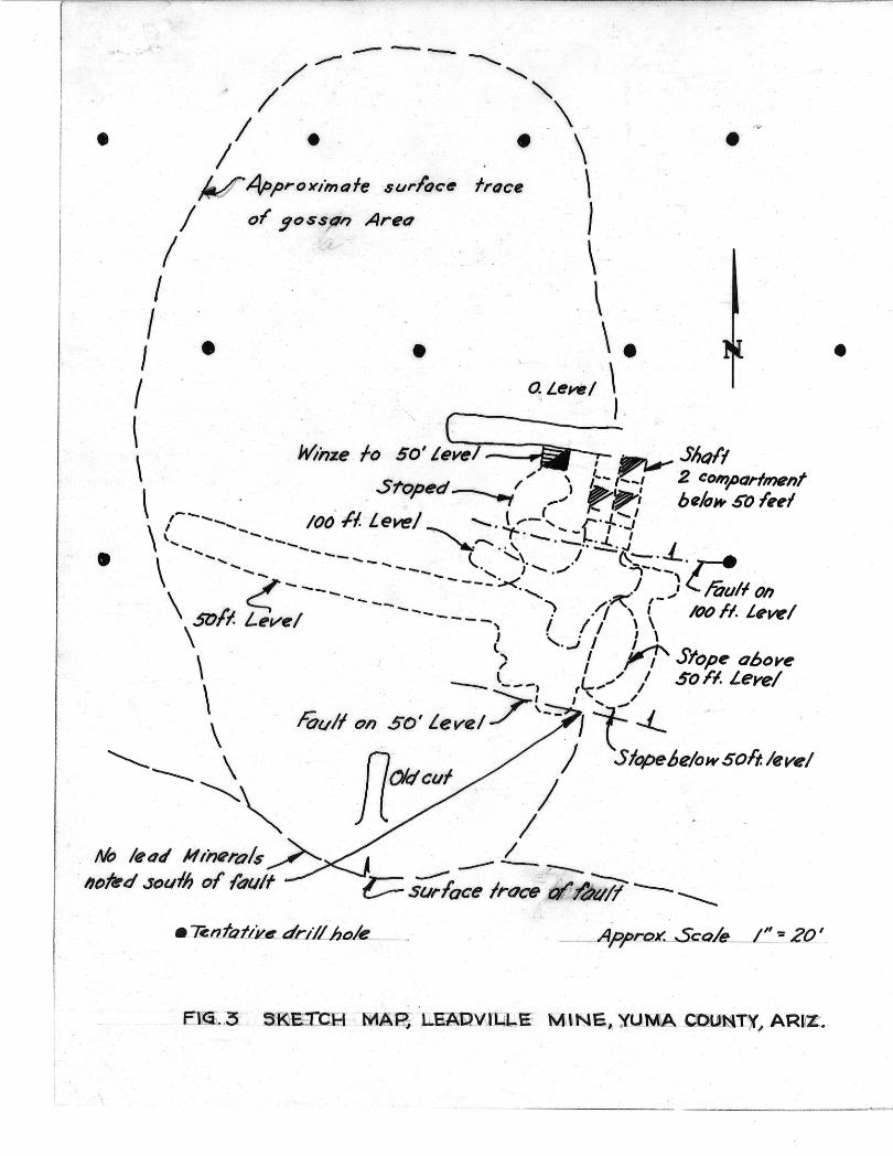
ADVILJ..E MINE
SEC. 4 J T. 3 N.) R. 20 W.
I-H-lle -
" QU~RTZlr£
.-._ AR.JZQtYA._
·ar-:.- ·,\-- rO--C-4"'~-;Knj~--Tao\A"'n\"/IUTI ~ ~A iI (I\o!I'r- vU-' 'k- j I~ ' tr)""f,- lll\.-IfT"\ ·y'--k~-r...,.---· . u.. L), ~ . R , ' 1~1~...lIl'!.l!~1 ~1,jLv. _ _ .J.U::;.-----I.~IJl lly:o.tot; ;I- _1- _008. ~~.JW DI , '), ,,,",'~ I 4-. ' .

...-.5ouln .
Mineralized P
\ eJorren
\
\ . --:----------.---~-----~'
I I '
--- ---/~ ~,
/ "\ /1 • . . • \
V 4p,Pro)(imafe $urloc~ !roce \ .
/ of ~ossfln Areo 1
• •
1\· ! . \ I • • \ • I ' a Lerl! I \ .
I "
\ WInze fo 50' LL, ;;;- iIIPI.- Sholl \ S1'o. ed / '" , l"-I~! 2 cOhI,POrlment \ . . 'P --,.., (_-' ~ be/ol4' .5tI f,,1
\ /----___ 100 II. -level ~ '-'~~"_('+'-: \'- ---- ' ~,......" •• , .--•• ~.J -L
\ '-.... ------ ~ '\. .I ~:::-. ' c.' -_ --_', J ........ / ' --. .... - '
- -- '-./ J'
c:! --- ----...,. I mulloh \ --- . ~ ,-.",
~r.J L / ------ · !·1 \ '\ /(J() ,fl. L,w/ .JvTl· eve . - - -, I I I \
\ l '.J I U \ ") I r I Sfop~ obove
, --. l L .",/,' So Ff. Level \ .. ~ ---I I'
•
\ roull on SO' Level./""t-- I J 't' -'- ' . ~--- \ - fl / Slope6e/ow5oft/eve/
--.... Old cui /
~~ I No leoti HIi'J"'ro/s ~
hDltrd so"lh of {duff
I , . -------~ , c::::- s-;;;roce ' lroc~ V I)fI-uil ---- ____
•

U
~F i
I PLAN OF MINERALI.ZE·O HIl'L.
4" "' " . ; I j I j N, . I, I. I I
1 LE'AOVILLE' GROUP , y ( i • I II •
SCale I =40
I .. rio
~SPf1lcP;/~s with ' "r,script . ''II'' . token by Heller a Oroper.
t " l' I
. s.o~plels ,!,9-?6lJ~:..~/5~~6155 . . Ioy Haliry 8 1 Huseman. ,,, I I \, t l. . I •
t 'U d'esignotll$ uno/tllred tuff. . ,,/ ,/'. f / I' ,
U 1/ ", (,,'v I{ . ~., 'v, .~ ) I
.-' . I