Embed Size (px)
Citation preview

Consultation Summary Document
Sizewell C ProposedNuclearDevelopment
Stage 2 Pre-Application ConsultationAutumn/ Winter 2016

B
A1094
B1069
B1119
B1122
A12
A12
A114
B1125
Woodbridge
WickhamMarket
Yoxford
Leiston
Southwold
Hacheston
Theberton
Saxmundham
Farnham
Darsham
Eastbridge
Westleton
Ipswich
Blythburgh
Key
Proposed power station location Page 8
Reserve park and ride facilities Page 26
Road Improvements Page 29
Temporary rail line extension option Page 22
Temporary park and ride facilities Page 26
Temporary campus accommodation Page 20
Temporary rail terminal option Page 23
Temporary marine facility options Page 24
Main development site Page 9
B1122A12Existing rail line
Temporary caravan park Page 19
Farnham road options Page 29LeistonLeistonLeistonLeistonLeistonLeiston
B106
9
B112
2
B1119
Leiston
Theberton
Eastbridge
Sizewell C proposals: location map

Foreword
I am pleased to present EDF Energy’s emerging proposals for a new nuclear power station, Sizewell C (SZC). Our latest plans have been informed by feedback from the Stage 1 consultation, on-going engagement, further technical work and environmental studies.
EDF Energy and China General Nuclear Power Corporation (CGN) recently entered into a partnership to develop new nuclear power stations in the UK. Work has begun on the building of Sizewell C's sister project in Somerset, Hinkley Point C, the UK’s first new nuclear power station since Sizewell B. The partnership also includes an agreement to take forward the development of the Sizewell C power station project. We have been working with CGN in China for more than 30 years and are delighted to be taking forward the Sizewell C proposals together.
Sizewell C would make a major contribution to the nation’s future needs for low carbon energy, supplying enough electricity for more than six million homes in Britain. Our vision for the Project is to create significant business, training and job opportunities for local and regional communities. We are also committed to limiting or mitigating any adverse effects of our proposals on local communities and the environment.
The feedback we receive from the local community plays an important part in the development of our proposals, so I encourage you to play an active role in this second stage of consultation. Our preferred proposals will be presented at a further stage of consultation.
The Sizewell C team will be available at our consultation events (see page 5 for information) to discuss the proposals and answer your questions. I hope you can join us and contribute to the further development of our plans.
Jim Crawford Sizewell C Project Development Director
Sizewell C consultation: where are we now?
Government consultation on
the strategic siting of new nuclear in
the UK
Nov 09 to Dec 10July 08 Oct 10 to Jan 11 Nov 12July 11 Nov 12 to Feb 13
Nuclear National Policy Sizewell C consultation
Government consultation on Nuclear National
Policy Statement (NPS) including potential sites
Decision by the Secretary of State
Planning Inspectorate examination
Development Consent Order
application submitted
Stage 3 / future consultation
Stage 1 consultation
SZC Statement of Community Consultation
(SoCC) published
Nuclear NPS ratified by Parliament
including designation of SZC site as suitable for Nuclear new build
Second consultation on Nuclear
NPSStage 2
consultation
WE ARE HERE
Updated SZC SoCC published
Nov 16 to Feb 17Nov 16
1
A1094
B1069
B1119
B1122
A12
A12
A114
B1125
Woodbridge
WickhamMarket
Yoxford
Leiston
Southwold
Hacheston
Theberton
Saxmundham
Farnham
Darsham
Eastbridge
Westleton
Ipswich
Blythburgh

Contents
1. The consultation 3
Consultation process 3
Development consent order 3
Preliminary environmental information 4
Scope of consultation: how to find out more and respond 4
Details of consultation events 5
2. Key changes since Stage 1 consultation 6
3. Sizewell C Power Station 8
Introduction 8
Components of the power station 8
Environmental considerations - main development site 9
Sizewell C site access 12
Construction and temporary development 14
4. People and economy 16
Introduction 16
Construction workforce 17
Supply chain 17
Education, skills and employment 17
Public services and community facilities 17
5. Accommodation and transport 19
Introduction 19
Accommodation 19
Accommodation management strategy 19
Transport 22
6. Additional information 38
UK EPRTM technology 38
Safety 39
Fuel and waste 39
Decommissioning 39
Wildlife habitat creation 39
Visitor centre 39
Purchase of land 39
7. Next steps 40
Responding to the consultation 40
What next 40
8. Questionnaire 41
This symbol appears throughout the document, highlighting where options are presented for feedback.
2

1. The consultation Stage 2: 23 November 2016 to 3 February 2017
Consultation process
EDF Energy1 intends to submit an application for development consent to build and operate a new nuclear power station, Sizewell C, along with the associated development (such as an accommodation campus and transport proposals) required to enable construction and operation. Before submitting the application we are consulting on our proposals.
In recognition of the amount of time that has passed, and in response to public feedback at stage one, our formal consultation programme now includes three formal public consultation stages, one more than originally proposed in 2012. This is Stage 2 of our pre-application consultation.
At Stage 1, which ran from November 2012 to February 2013, we consulted on our initial proposals and options.
Overall 1,298 responses were received to the Stage 1 consultation, which included:
• Direct engagement with over 4,000 local people;
• Exhibitions, drop-in sessions and meetings with residents;
• Presentations to parish and district councils;
• Meetings with the New Anglia Local Enterprise Partnership, business organisations and chambers of commerce; and
• Working with groups representing people with disabilities, older people, black and minority ethnic groups and young people.
As well as considering feedback received at Stage 1, we have continued to engage and receive informal feedback from community groups, parish councils and other stakeholders since February 2013.
In 2014, we undertook some informal engagement with local communities as we progressed our thinking on site options for the accommodation campus and park and ride sites.
National and local planning policy, along with feedback from the first stage of consultation, on-going engagement and technical and environmental information from further studies, modelling and assessments, has helped shape our plans. The Stage 2 strategies and proposals are summarised in this document and more detailed information is available in the Stage 2 Consultation Document.
The Stage 2 consultation is open until 3 February 2017 and responses must be received by this date. Following Stage 2 we will consider all responses and use them to further inform the development of our plans. We will publish our preferred proposals alongside more technical and environmental information at a further stage of consultation, which will pave the way for the submission of an application for development consent. If necessary we will also undertake limited, focused stages of consultation if specific issues or significant changes arise. Further consultation will be promoted in advance.
Before we began the Stage 1 Consultation, we prepared and published a Statement of Community Consultation (SOCC) explaining how we proposed to consult the local community about our proposals. Since then we have decided to include an additional stage of formal consultation. An ‘Updated SOCC’ was prepared to reflect the revised approach. We consulted the relevant local authorities and our ‘Updated SOCC’ is available online: www.sizewellc.co.uk.
Development consent order
Sizewell C is classed as a Nationally Significant Infrastructure Project (NSIP) under the Planning Act 2008.
Following pre-application consultation, we will make an application to the Planning Inspectorate in the form of a development consent order (DCO). The Planning Inspectorate will process and examine the application before making a recommendation to the relevant Secretary of State, who will make the final decision on whether or not to grant consent for Sizewell C.
More information on the NSIP planning process can be found at: http://infrastructure.planninginspectorate.gov.uk
1 NNB Generation Company (SZC) Limited (Company No. 9284825), whose registered office is at 40 Grosvenor Place, London, SW1X 7EN (referred to in this document as ‘EDF Energy’)
3

Preliminary environmental information
We need to assess the likely significant effects of the Sizewell C Project on the environment and will therefore carry out an Environmental Impact Assessment (EIA). A full Environmental Statement (ES) and non-technical summary will be submitted as part of our application for development consent. The ES will be informed by consultation, including Stage 2, which explains how the current technical and preliminary environmental information has informed our emerging strategies and proposals.
Further details on the EIA process can be found in Section 12 of the Stage 2 Consultation Document.
The initial findings of the EIA will be provided at a later stage of consultation, including baseline environmental information.
Scope of consultation: how to find out more and respond
Following feedback from the Stage 1 consultation and ongoing technical and environmental input, we have developed a preferred position on some of the key elements of our proposals, whilst other parts of our plans remain as options.
We are seeking your views on all aspects of our Stage 2 strategies and proposals and encourage you to comment on:
• our overall proposals for the Sizewell C nuclear power station, whether presented as options or preferred proposals;
• the associated development needed to support the construction and operation of the power station; and
• the potential effects of the Project, both positive and negative - and proposed mitigation measures where necessary.
Respond to the consultation:
Get in touch: call freephone 0800 197 6102 during normal office hours.
Check out the website: www.sizewellc.co.uk
Visit the Sizewell C Information Office in Leiston
Attend our exhibitions
Find out more detail in the Stage 2 Consultation Document
Read this Stage 2 Consultation Summary Document
Call our freephone number 0800 197 6102 during normal office hours.
Post your written responses to FREEPOST SZC Consultation(no stamp or further address required)
Email your comments to [email protected]
Complete a questionnaire: Online www.sizewellc.co.ukOr in hard copy and post it to our freepost address (see below)
Learn about the proposals:
The principle of the need for new nuclear power stations and the choice of Sizewell as a potentially suitable site have already been determined by Parliament, following public consultation and debate. These issues are outside the scope of this consultation.
Copies of all the consultation documents are available in hard copy and on disc at the exhibitions and at the Sizewell C Information Office, open from 9.30am- 5pm Monday - Friday and 9am-12pm Saturday (48-50 High Street, Leiston, IP16 4EW). They will also be available to view during normal
office hours, in the offices of Suffolk County, Suffolk Coastal District, Waveney District and Ipswich Borough Councils as well as local public libraries. They are also available on the Project website: www.sizewellc.co.uk
If you require the consultation information in a different format for accessibility reasons, please call (0800 197 6102) or email [email protected].
Please remember that the deadline for responses to our Stage 2 consultation is 3 February 2017.
1. The consultation
4

Consultation event locations
We will be holding consultation events at the following locations:
• Aldeburgh
• Blythburgh
• Campsea Ashe
• Darsham
• Hacheston
• Halesworth
• Ipswich
• Leiston
• Lowestoft
• Marlesford
• Melton
• Middleton
• Rendlesham
• Saxmundham
• Sizewell
• Snape
• Southwold
• Stratford St Andrew
• Theberton & Eastbridge
• Westleton
• Wickham Market
• Woodbridge
• Yoxford
Details of the times and venues can be found in our Stage 2 newsletter and on the project website: www.sizewellc.co.uk.
Alternatively, please call 0800 197 6102 for more information about the consultation events. If you are unable to attend the exhibitions, copies of the exhibition boards will be available to download from the project website.
5

2. Key changes since Stage 1 consultation
Feedback from Stage 1 consultation, on-going engagement and further technical and environmental work has resulted in some key changes to our initial proposals and options, which are highlighted below and, for the main development site, illustrated in Fig 2.1.
Main development site
• Layout of the power station - some relatively small-scale changes have been made to the footprint of the permanent development following further studies and technical work. We are also considering alternative bridging and causeway proposals for the temporary and permanent crossing of the Site of Special Scientific Interest (SSSI).
• Access road - a roundabout to link with the B1122 is now proposed (rather than the T-junction shown at Stage 1).
• Soil management - we are proposing options for use of an on-site ‘borrow pit’ to manage excavated material while retaining the option of dispatching material to the RSPB’s Wallasea Island habitat creation scheme in reserve.
• Outfall location for Sizewell C cooling water - our selection of offshore outfall locations (rather than inshore of the Sizewell Bank as proposed at Stage 1) will reduce potential effects on the local marine ecology.
• Visitor centre - a visitor centre remains a core part of the Sizewell C proposals, however updated proposals will be presented at a future stage of consultation.
Accommodation
• Campus location - we have identified the main development site as our preferred campus location and are consulting on layout and access options. We are not taking forward the other sites proposed at Stage 1 consultation.
• Campus size - we have reduced the size of the accommodation campus to up to 2,400 bed spaces, from a maximum of 3,000 proposed at Stage 1.
• Temporary caravan accommodation - we are proposing use of land east of Eastlands Industrial Estate (on the east edge of Leiston) as an option for a temporary caravan park during construction.
Transport
• Rail - two options are now proposed: a rail extension of Saxmundham-Leiston branch using the green route identified at Stage 1 (preferred over the other two Stage 1 route options) and potential extension further into the site or a new rail terminal and freight laydown on land east of Eastlands Industrial Estate.
• Sea transport - in addition to the temporary jetty and the permanent beach landing facility (BLF) in Stage 1, we are proposing a narrower jetty and potential use of the BLF during construction as further options for marine delivery.
• Northern park and ride - Darsham is our preferred site, whilst another Stage 1 option, the A12/A144 site, is being held in reserve. The Yoxford Road site has not been taken forward.
• Southern park and ride - Wickham Market is our preferred site (with a different site boundary to Stage 1 following further archaeological investigations). The Stage 1 option at Woodbridge is being held in reserve. The Potash Corner site has not been taken forward. The proposals now include a postal consolidation facility and incident holding area where HGVs can temporarily stop.
• Induction centre - this has been removed from the park and ride proposals and relocated to the main development site.
• Lorry management - a freight management facility is no longer proposed. We now consider HGV movements can be effectively managed through other means, such as an electronic Delivery Management System (DMS) and use of Automatic Number Plate Recognition (ANPR).
• Road improvements:
- A12 - we have developed our proposals for mitigating traffic impact at Farnham and now have four options: no change; widening the road at the Farnham bend; a one-village bypass of Farnham; or a two-village bypass of Farnham and Stratford St Andrew (at the request of Suffolk County Council).
- B1122 - we have developed a number of road improvement options along the B1122, including options for a roundabout or signalised junction at Yoxford.
6

Fig 2.1: Main development site changes since Stage 1
WMZ - Water Management Zone
7

Introduction
We plan to build and operate a new nuclear power station in Suffolk on land immediately to the north of Sizewell B power station, adjacent to an area that has had nuclear power stations operating since 1966.
Feedback from Stage 1 Consultation, on-going engagement and further technical and environmental work have resulted in some key changes to our initial proposals and options, highlighted on page 6, summarised in this document and explained in more detail in the Stage 2 Consultation Document.
Should we receive the necessary consents, and once the site has been prepared, we expect that construction of the power station would take 10 to 12 years.
Components of the power station
The proposed layout of the Sizewell C buildings takes into account the sensitive nature of the surrounding environment while providing enough space to build and operate the power station safely and efficiently.
The permanent components of the power station would be:
• two UK EPRTM reactor units made up of reactor buildings and associated buildings (the ‘Nuclear Island’), and turbine halls and electrical buildings (the ‘Conventional Island’);
• fuel and waste facilities, including interim storage for radioactive waste and spent fuel;
• external plant including storage tanks;
• operational service centre and ancillary, office and storage buildings;
Fig 3.1: Indicative operational masterplan
3. Sizewell C Power Station
• cooling water infrastructure including pumphouses, associated buildings, tunnels extending out to sea and headworks;
• drainage and sewerage infrastructure;
• transmission infrastructure including a National Grid 400kV substation, removal and relocation of one existing National Grid transmission tower (pylon) and associated realignment of power lines;
• internal roads, an access bridge or causeway, car parking and an off-site vehicle search area;
• sea defences and a beach landing facility;
• access road to adjoin the B1122 and related junction improvements; and
• landscaping of the areas to be restored following use during construction.
Safety considerations, assessed by the Office for Nuclear Regulation (ONR), mean the design of the nuclear safety structures comprising the majority of the power station, such as the reactor buildings, are fixed in terms of their layout, shape and external appearance. Other buildings such as the turbine halls do offer some scope for using different materials.
8

Environmental considerations - main development site
Construction and operation of the power station would have an impact on the surrounding environment. A number of the most likely potential impacts related to the Sizewell C site are outlined in this section and more information is available in Section 7 of the Stage 2 Consultation Document.
On-going surveys and assessments have fed into our latest proposals and more detailed environmental information will be available at a later stage of consultation.
Landscape and visual
The Sizewell C site is within the Suffolk Coast and Heaths Area of Outstanding Natural Beauty (AONB) and on the Suffolk Heritage Coast. Our proposals have been designed to mitigate landscape and visual effects of the power station on these areas as much as possible.
Our overall approach to the landscape strategy is to restore and enhance areas used for construction and, where possible, take the opportunity to enhance the landscape, biodiversity and recreational value of the wider EDF Energy Sizewell Estate2.
The way Sizewell C’s more prominent buildings are likely to be viewed in the landscape can be seen in outline in the indicative views provided (fig 3.3 and 3.4).
There will also be visual impacts during construction, for example, in relation to the use of stockpiles for storage of fill material and top soil and construction site cranes (see page 14 for more information).
2 The area owned and managed by EDF Energy, largely bound to the north by the RSPB Minsmere Nature Reserve, to the south and west by Sizewell Gap/Lover’s Lane and to the east by the intertidal beach. Sizewell A does not form part of the EDF Energy Estate.
Fig 3.2: Indicative phased restoration plan
Fig 3.3: Indicative view looking east from Abbey Lane near to the Cakes & Ale Caravan Park
Fig 3.4: Indicative view looking south along the foreshore from the northern mound
Post constructionlandscape enhancement
Post construction restoration and landscape enhancement
Aldhurst Farm SSSI habitat creation and landscape
enhancement scheme currently being implemented
Reptile mitigation and landscape enhancement scheme currently
being implemented
North Sea
Sizewell C Power Station
Sizewell B Power Station
Sizewell A Power Station
9

Historic environment
Work since Stage 1 has revealed there is potential for buried archaeology to be present across the main development site. A programme of trial trenching and targeted excavation of areas of highest archaeological potential will determine the nature, extent and importance of any surviving archaeological remains. A mitigation strategy, which is likely to include excavating and recording features of archaeological interest found, will be developed.
The design of the power station will consider potential effects on the settings of designated heritage assets nearby. We will aim to avoid or minimise any potentially significant effects where possible.
Since Stage 1 consultation, we have redesigned the site entrance (see Section 7 of the Stage 2 Consultation Document), moving it slightly to the east. Further assessment will identify potential impacts and mitigation, particularly in relation to Leiston Abbey.
Noise
Noise during construction would be from earthworks and construction of contractors’ areas and facilities. The main sources of noise would be excavators, bulldozers, cranes, steel erection and asphalting plant. Once the contractors’ areas are established, the principal noise sources would be from steel fabrication, vehicle movements and deliveries, and the operation of the concrete batching plant. Further analysis of the different activities across the main development site - and over the different phases of work - will be done to understand potential impacts to nearby homes and ecology and to inform the need for mitigation measures.
Operational noise would be low and unlikely to be significantly different from that of Sizewell B.
Lighting
The aim of our lighting strategy for both construction and operation will be to provide a safe and secure working environment while minimising potential impact on light sensitive areas, for example near to homes. Lighting on the foreshore during construction and operation would be limited to that which is required to ensure safety for specific activities. We will present more detail on our lighting strategy at a later stage of consultation.
Air quality
During construction, some works within the contractors’ compound, including soil stripping, site leveling, and the construction activities themselves, have the potential to generate emissions to the air through wind-blown dust and on-site plant exhaust.
The control of construction dust would be achieved with the adoption of good working practices and other measures. These measures will be developed as an outcome of the air quality assessment undertaken during evolution of the site design, and will be incorporated into a dust monitoring and management plan.
When operational, Sizewell C would include standby diesel-fired generators, to provide power to the site in the event that electricity supplies from the national grid are lost. These generators would emit relatively small quantities of nitrogen oxides, sulphur dioxide and carbon monoxide. However, they would only be run for test purposes or in the event of a loss of electricity supplies and no adverse effects on the local environment are predicted.
Footpaths and bridleways
We recognise that footpaths/bridleways and access to the beach are important. Our approach aims to minimise disturbance, retain connectivity and provide appropriate diversion routes and mitigation during construction. Advance notice would be given of any closures or diversions of footpaths and bridleways.
For operation, we plan to restore the majority of closures and diversions, improve amenity across the EDF Energy Estate network and increase connectivity from Sizewell C to the wider area.
During construction of Sizewell C, Bridleway 19 (running north/south by Upper Abbey Farm) would be diverted and some footpaths, including portions of the Suffolk Coast Path and Sandlings Walk, would be temporarily diverted to ensure public safety during essential engineering works.
A new north/south, off-road route (running parallel to Lover’s Lane and the B1122) suitable for horses, cyclists and pedestrians is proposed during construction and could be retained during operation. For more information on pedestrian and cycle routes, see Section 11 of the Stage 2 Consultation Document.
Flood risk assessment
Between 2012 and 2014, we carried out studies to understand the flood risk associated with the sea and identify other potential flood sources.
Early studies have helped inform our understanding of potential issues and our approach to mitigation. We are working closely with the Environment Agency and other key organisations, including local authorities and the local Internal Drainage Board, and will present further detail at a later stage of consultation.
3. Sizewell C Power Station
10

Our proposed development is expected to have very little effect on coastal processes whilst the local shoreline maintains its current position. Should the shorelines to the north or south retreat, elements of the Sizewell C power station would help to hold the line of the shore, protecting the site behind from erosion.
Our continuing studies will help us determine how best to protect Sizewell C while limiting effects on the local environment as far as practicable, including in relation to any temporary jetty structure (see page 24 for further information). The future evolution of the coastline itself and the offshore Sizewell and Dunwich Banks, and the potential long-term interactions between the Minsmere Sluice, local shores and Sizewell C, are also being considered as part of our studies.
We are proposing to maintain the existing alignment of the Sizewell A and Sizewell B eastward building line for the Sizewell C power station buildings. However, the design of the UK EPRTM means it would be necessary to build new sea defences slightly further east, but still within the EDF Energy Sizewell Estate. As well as providing flood defence and coastal protection for the power station, they would help screen the lower parts of the development. These permanent sea defences would be landscaped as an embankment, similar to the Sizewell B sea defence (which is 7-10m AOD or Above Ordnance Datum).
A landscape scheme for the sea defences has also been prepared that takes into account landscape, biodiversity and recreational considerations.
Ecology
The Sizewell C site is bordered by areas of ecological sensitivity and would require a small part of the Sizewell Marshes SSSI to be developed. As outlined on page 39, to help compensate for the use of SSSI land, we are working on habitat creation schemes that would result in a substantial area of inter-connected, semi-natural habitat.
The land temporarily used during construction would be restored and include a combination of woodland planting and the creation of heath, scrub and grassland.
We have been working closely with the Centre for Environment Fisheries and Aquaculture Science (CEFAS) to understand the potential impact on marine ecology and fisheries so we can introduce mitigating measures where appropriate.
Our selection of offshore outfall cooling water locations for Sizewell C - rather than locations inshore of the Sizewell Bank (as proposed at Stage 1) - would reduce potential effects on the local marine ecology. Other mitigation measures are likely to include mechanisms to deter fish from entering the cooling water intakes and return those fish that do enter the intakes to the sea.
Coastal processes
We have been monitoring coastal processes in the area surrounding Sizewell C for a number of years. Studies have involved the use of a number of tools, such as radar and remotely piloted aircraft.
Studies show that our proposals would have only minor impacts - such as localised changes to the sea bed or potential change in surface sediments around our cooling water intake and outfall structures or any cross-shore structures - which could result in limited habitat change. We will monitor the level of change and mitigate as appropriate.
Fig 3.5: Indicative cross-section of sea defences
11

Sizewell C site access
New access road
We propose to build a new, permanent access road to link Sizewell C to the B1122. This would be the main route to bring workers and materials onto the site during construction and the main access for Sizewell C once the station is operational.
This access road is a regulatory requirement, as all new nuclear power stations need to have two separate accesses. The existing Sizewell power station complex road would provide the secondary access.
The proposed access arrangements include:
• a new roundabout, located slightly eastwards of the existing alignment of the B1122, to form part of the main development site entrance;
• at the eastern end of the road near to the power station, a staff car park with 700 spaces for day-to-day operational staff and an area for additional parking (500 spaces) and laydown to be used during maintenance periods; and
• a vehicle search area facility and other ancillary buildings, including potential training facilities.
The width of the access road would be reduced once Sizewell C is operational and would include a pedestrian walkway and cycle path. Apart from the junction with the B1122 and the car park area, the access road would not be lit during operation.
Option 1: causeway over culvert
• Temporary crossing: early, lower level causeway that would be built up to form the permanent crossing during the construction phase.
• Permanent crossing: higher level causeway that would be retained throughout operation of the power station.
This option provides a crest wide enough (42.5m) for both permanent and temporary road crossings of the SSSI.
An area of 10,900m2 is required for this option.
Fig 3.6: Option 1 - causeway over culvert
Options: SSSI crossing4 available options
A new north/south, off-road route (running parallel to Lover’s Lane and the B1122) suitable for horses, cyclists and pedestrians is proposed during construction and is proposed to be retained during operation. For more information on cycle routes, see page 36.
The new access road would need to cross the Sizewell Marshes Site of Special Scientific Interest (SSSI), going across the watercourses and between the construction area and the main power station area. Following feedback from Stage 1 consultation and with a more detailed construction programme, we are now considering four options, which include proposals for temporary (short and longer term) and permanent crossings.
There are a number of factors to consider in identifying a preferred option. For instance Option 1 would involve a single time-limited operation in the SSSI, whilst Options 2 and 3, and to a lesser extent Option 4, would be more complex to build with short term, temporary and permanent installations erected at different times. Also, for Option 1, planting on the causeway would help integrate the crossing into the surrounding landscape, whilst the bridges for Options 2 and 3 would be distinct structures that would be more visible, especially in local views from the surrounding footpath network.
Our initial view is that Option 1 is preferred as it would involve a less complex construction process with no short term or temporary bridges required. Planting on the slopes and either side of the access road platform would enable the feature to ‘settle’ into its surrounds over time, with maintenance being confined to the culvert.
Causeway road layout during construction
Power station under construction
3. Sizewell C Power Station
12

Option 4: causeway over culvert with adjacent short-term bridge
• A short-term, limited capacity bridge that would be removed part way through the construction phase.
• Permanent crossing: a causeway would serve the remainder of the construction phase (once the short-term bridge is removed) and be retained throughout operation of the power station.
An area of 12,900m2 is required for this option.
Option 3: three span bridges
• A short-term bridge, erected in the location of the permanent bridge, to operate until the temporary bridge is built.
• Temporary crossing: a three span bridge that would be removed following the construction phase.
• Permanent crossing: a three span bridge, to be erected when the short-term bridge is removed, that would operate alongside the temporary bridge during construction and be retained throughout operation of the power station.
An area of 7,750m2 is required for this option.
Option 2: single span bridges
• A short-term bridge, erected in the location of the permanent bridge, to operate until the temporary bridge is built.
• Temporary crossing: a single span bridge that would be removed following the construction phase.
• Permanent crossing: a single span bridge, to be erected when the short-term bridge is removed, that would operate alongside the temporary bridge during construction and be retained throughout operation of the power station.
An area of 8,385m2 is required for this option.
Fig 3.7: Option 2 - single span bridges Fig 3.8: Option 3 - three span bridges Fig 3.9: Option 4 - causeway over culvert with adjacent short-term bridge
Power station under construction
Power station under construction
Power station under construction
Permanent bridge
Temporary bridge
Temporary bridge
Permanent bridge
Short-term bridge
Permanent causeway
13

Beach landing facility (operational phase)
At Stage 1 consultation, it was suggested that some elements of the jetty structure (see page 24) might need to be retained on a permanent basis. It is now considered that a beach landing facility (BLF) would be required for operation of the power station to:
• facilitate an occasional but essential need to transport across the shore exceptionally large loads that are too heavy for transportation by road; and
• potentially perform a role in coastal protection through its design and location.
The BLF would be connected to Sizewell C by an access road that would run the north side of the Northern Mound. The BLF would be built at the beginning of the construction period and concealed as far as possible within the design of the sea defences. We estimate it would be used infrequently, approximately every 5-10 years for a few weeks at a time, during which we would endeavour to keep any beach closures to a minimum. We are also considering the potential for using the BLF during construction (see page 25).
Construction and temporary development
Main development site
Key considerations for the temporary development and construction activities are to avoid the most sensitive landscapes and habitats within the AONB and locate activities with the most potential for disturbance away from where people live. In order to achieve this, the majority of works are proposed on agricultural and commercial forestry land within a broad corridor from Goose Hill in the east to the B1122, near Upper Abbey Farm, in the west.
Existing woodland and areas we have identified for early tree/hedgerow planting would help screen activities at key locations, including the proposed site entrance and along the northern perimeter. Differences in the height of land to the north and south of the site would also help screen construction site activity from wider views.
Interim sea defence arrangements are also proposed during construction.
A site entrance hub east of the new B1122 junction would serve as an access point for goods vehicles transporting construction materials as well as for workers and visitors to the site. It would ensure safe, secure access to the site and include a site office, induction centre and canteen. A freight area with a checkpoint, security checking facilities and parking is also proposed.
A secondary access road would be required to connect the main development site from Lover’s Lane to the land east of Eastlands Industrial Estate.
An integral part of the proposals for the main development site is a workers’ accommodation campus. It will help to mitigate potential impacts on local communities through the significant benefits it offers in terms of reducing journeys on local roads and wider worker management.
More information on our accommodation strategy and the campus proposals can be found on pages 19-21.
Managing construction materials
Construction of Sizewell C requires deep excavation that would generate significant quantities of spoil and a need for material to replace or backfill it. The excavated and backfill material would need to be stockpiled at different points in the construction phase.
We are proposing to source construction material for use in building the power station from one or more ‘borrow pits’ located in the north-west of the site. This land would be backfilled with peat and clay that will be excavated from the foundation area of the power station.
Stockpile areas will generally rise during the early years of construction as spoil is excavated and stored and reduce in height in later years as material is used. Our current expectation is that the maximum stockpile height would be 20m-35m.
For the borrow pit operation we need around 15 hectares of land and have identified four suitable fields (see fig 3.10: Indicative construction masterplan). Due to the size of the fields and the practicalities of the borrow pit operation,
three potential field combinations are being considered:
Option 1: Field east of Eastbridge Road (field 1) and field west of Eastbridge Road (field 2)
Option 2: Field west of Eastbridge Road (field 2) and field north of Ash Wood (field 3)
Option 3: Field north of Ash Wood (field 3) and field west of Ash Wood (field 4)
Options: Borrow pits3 available options
3. Sizewell C Power Station
14

TEMPORARY JETTY (WIDE OPTION)
Sizewell BPower Station
LAND FOR PRE-ASSEMBLYMATERIALS STORAGE AND
CONSTRUCTION SITE LOGISTICS
Kenton Hills
Goose Hill
Great Mount Wood Dunwich Forest
Sizewell APower Station
NORTH SEA
CONTRACTORS’ COMPOUNDS
COMMON USER FACILITIES
MAIN POWER STATION PLATFORM
CONTRACTORS’ COMPOUNDS
ACCOMMODATION CAMPUS
(OPTION 1)
Secondary HGV access
Water Management Zone
SSSI Crossing
SITE ENTRANCE Re-aligned ditch
Indicative cutoff wall
Permanent sub station
Leiston Abbey
Realigned Lover’s Lane access
National Gridconstruction working area
Water Management Zones
Water Management Zone
Water Management Zone
Green rail route
Perimeter constructionaccess road
Re-aligned ditch
Sizewell railhead
UpperAbbey Farm
Site Office and Induction Centre
THEBERTON
EASTBRIDGE
Car park
NORTH SEA
Diverted Eastbridge Road
BEACH LANDING FACILITY
SIZEWELLVILLAGE
The Round House
LOVER’S LA
NE
Greater Gabbardsubstation
Gallopersubstation
(under construction)
ABB
EY R
OA
D (B
1122
)
Abbey Cottage
LEISTON
POTT
ERS
ROA
D
Ash Wood Cottages
Car Parking
Freight Parking
Buses
Grimseys
Caravan Area
Temporary Holding Area
Ash Wood
STOCKPILE AREA
TOPSOIL STORAGE
Potter’sFarm
EASTBRID
GE RO
AD
BORROW PIT FIELD 1
BORROW PIT FIELD 2
BORROW PIT FIELD 3
BORROW PIT FIELD 4
Fig 3.10: Indicative construction masterplan
The borrow pit proposal supports our preference for keeping material on site, which would reduce lorry movements and give us greater certainty over excavation timings. However, if on-site spoil management is not feasible, we would investigate the potential of shipping our unusable material to the RSPB Wallasea Island Wildlife Coastal Project in Essex for use in its ongoing habitat creation scheme.
Off-site construction support
Other materials will be transported to the site by road, sea and rail. A temporary jetty would allow delivery of very large loads of bulk construction materials and removal of excavated materials by sea if needed (see page 24 for options).
We propose to use land near the existing railhead in Leiston, immediately to the east of the Eastlands Industrial Estate for construction purposes such as storage of non-bulk material, a short-term park and ride area (avoiding the need for on-site car parking in the early years of the Project) and a HGV holding area. It is one of the options for a rail terminal (see page 23) as well as a site for temporary caravan accommodation.
Use of this land is particularly important in the early phase when the main construction site is being established, space is limited and the accommodation campus is being built. The caravan facility, located in the north of the site, would continue to operate throughout the construction phase, as a means of accommodation for the construction workforce (see page 19 for more information on our accommodation proposals).
Site Boundary
Main Power Station Platform
Supplementary planting
Early planting
Existing Principal WoodlandAreas
Contractor Compounds
Sizewell B Relocation Works(and Pillbox)
National Grid ConstructionWorking Area
Land for pre-assembly,material storage and construction sitelogitics
Spoil Management Zone
Accommodation Campus
Water Management Zone
Buffer Zones and landscaping
Site Entrance Hub
Access Road
Haul Road
Rail Route and Corridor
Potential rail extension tobatching plant works
Diverted section of EastbridgeRoad
15

4. People and economy
6,000
5,000
4,000
3,000
2,000
1,000
0
Civils Contructions
Mechanical & Electrical
Professional, Management and Administrative
Operational Staff
Total Workforce
Fig 4.1: Indicative Sizewell C construction labour demand curve - estimated workforce numbers
Introduction
A project of the scale and complexity of Sizewell C would bring significant economic and employment opportunities, supporting the security of the UK’s economic future as well as producing a long-term boost for the local economy through increased employment and skills provision.
Approximately 25,000 roles would be created throughout the construction period as well as a long-term legacy of 900 new jobs once the station is operational. Additional staff would also be employed during refuelling and maintenance outages, expected to take place approximately every 18 months for each reactor unit and lasting between one and three months.
Other jobs would also be created in the regional and national economy through increased spending and supply chain opportunities in a range of sectors. A twin EPRTM power station is expected to put at least £100 million a year into the regional economy during peak construction and £40 million a year during its 60 years operation.
The feedback from Stage 1 consultation focused on the following key areas:
• the effect of construction - and, in particular, the construction workforce - on local communities and their access to services and facilities;
• the opportunities to maximise local employment, skills and business benefits; and
• the potential impacts on existing sectors such as tourism.
Our aim is to enhance the social and economic benefits of Sizewell C while limiting adverse local impacts. Potential impacts on local communities such as Leiston, Theberton and Eastbridge may arise due to a combination of social,
economic and environmental factors. The application for development consent will include a community impact assessment describing the impacts and potential mitigation measures.
Since Stage 1 consultation we have worked closely with local authorities and other organisations to address the key issues raised and welcome feedback on our revised plans.
16

Construction workforceOur work since Stage 1 consultation has given us more information on issues like ground conditions and the effect these would have on our method and process of construction. As a result, we have amended our estimate of the number of workers we will need in the early years of construction. Our peak construction workforce of 5,600 workers on the main development site remains the same.
We will try to recruit as many local people as possible for the construction phase. Since Stage 1 consultation we have reviewed the likely proportion of workers we think can be drawn from existing residents, based on skills in the local area. These workers (home-based) would commute to site each day. Those who do not live locally (non-home-based workers) would find temporary accommodation in the area. We now estimate that 36% of the peak construction workforce would be recruited from the local area compared with 34% stated at Stage 1 consultation. These calculations help to inform our accommodation strategy (see page 19).
Supply chain
Where possible, we are aiming to ensure local businesses can compete for the significant number of contracts needed to build, support and operate Sizewell C. We are currently funding a Suffolk Chamber of Commerce scheme to help local companies get ready for the opportunity. Over 800 companies have registered their interest in the Sizewell C supply chain portal to date.
For more information or to register an interest, visit: www.sizewellcsupplychain.co.uk.
Education, skills and employmentMaking sure local people are able to access the jobs, skills and other economic benefits Sizewell C would bring is essential. We will continue to work in partnership with local education and training providers in addition to delivering national programmes and initiatives run by EDF Energy, including existing programmes at Sizewell B.
We are working with skills and education providers and industry skills/training bodies to identify skills and qualifications needed to support the construction of Sizewell C, as well as meet the wider economic development aspirations of the region. A fundamental aspect of our work is the promotion of sustainable careers in the key sectors of the economy that will support the construction of Sizewell C.
Since Stage 1 we have engaged with Suffolk County Council's skills and education team, all Suffolk Further Education colleges, the East of England Energy Group, and the New Anglia Local Enterprise Partnership to start to understand the existing range of courses offered and initiatives in place, such as 'Raising the Bar' and 'Developing Suffolk Talent', which are designed to enhance aspirations, attainment and participation.
An Education, Skills and Employment Strategy, including measures to boost local skills and establish a jobs brokerage to help local people into suitable roles, will be submitted as part of our application for development consent.
Tourism
Tourism is an important source of jobs and income in many areas of the rural economy, in particular within the Suffolk Coast and Heaths Area of Outstanding National Beauty (AONB). We will continue to work with local tourism bodies, local authorities and businesses to support the long-term sustainability of tourism and work to understand how the sector might be affected by Sizewell C.
Public services and community facilities
We recognise local concerns about the impact of construction, including the size, location and activities of the workforce.
In collaboration with local authorities, emergency services and public services, we will develop a Community Safety Management Plan to address issues that may arise from the arrival of Sizewell C workers to the area. We will also ensure high standards of behaviour both on-site and in the community, requiring all Sizewell C workers to sign and comply with a strict Code of Conduct and drug and alcohol testing policies.
We will develop the Code of Conduct in partnership with contractors and include it in contracts to ensure prompt and effective action is taken to address any unacceptable behaviour. A similar Code of Conduct was implemented during construction of West Burton B (our combined cycle gas turbine power station in Nottinghamshire) and proved to be highly effective.
At Stage 1 Consultation, people also expressed concern about the pressure on community facilities like schools and healthcare. Following Stage 2, we will undertake further detailed analysis of potential local impacts on public services and community facilities, such as school places, GPs, police and other emergency services.
17

1818

5. Accommodation and transport
Introduction
Since Stage 1 consultation we have developed our plans with the aim of minimising the impact of the construction of Sizewell C on local communities. We are working to reduce the potential pressure on local roads caused by our workforce and the movement of construction materials by:
• building a temporary accommodation campus (up to 2,400 bed spaces);
• using park and ride facilities to reduce the number of worker car journeys; and
• moving construction materials by sea and rail where possible.
Accommodation
Our overall aim is to strike a balance between providing purpose-built accommodation (to maintain productivity and safety and reduce traffic effects) and using local accommodation (to promote economic benefits), while minimising any adverse effects on local communities and the housing market. This is to make sure the local community benefits from worker spend in the area, while negative effects on accommodation capacity, affordability and community cohesion are limited.
We now estimate that at peak construction of Sizewell C around 2,000 (36%) of the construction workforce would live at home and commute to work. The remaining 3,600 (64%) would live in temporary accommodation in the area (see page 20).
We expect most home-based workers to commute from within 90 minutes of the site. We have estimated where these workers would be drawn from based on the current location of residents with appropriate broad skills.
Provision of a single, high quality, on-site accommodation campus where a significant proportion of workers can stay for varying lengths of time to complete their tasks is the most practical way to deliver Sizewell C. Locating the campus on-site has significant benefits in terms of reduced journeys and wider worker management, including helping to mitigate the impacts of large groups of construction workers on small rural communities.
We anticipate non-home-based workers would want to live close to the site to minimise daily travelling time, likely within a 60 minute commute. These workers would seek a range of accommodation depending on their role and the length of their contract. Short and medium term workers are more likely to look for accommodation in the private rented and tourist sectors (including caravans) as well as in our purpose-built campus (see page 20) and proposed caravan accommodation. Some workers in the area for longer periods, for example those in management and professional roles or future operational staff, may look to buy homes.
Accommodation management strategy
We will be working with local authorities and accommodation providers to maintain an attractive and balanced range of accommodation in the area to meet the needs of our construction workforce, while avoiding exacerbating existing housing need.
We will establish an accommodation office to support non-home-based workers with local providers and residents able to register any availability/spare rooms. We will review where workers are looking for accommodation and help signpost them to available accommodation to help avoid potential adverse effects on the local letting, management and tourism sectors.
We will work with local authorities to identify where existing pressures on the housing market may be exacerbated by Sizewell C workers and develop a range of measures that could be implemented to avoid or minimise adverse effects across the housing market, for example by bringing empty houses back into use.
1919

Main development site campus
We are proposing to develop a single campus on the main development site, within walking distance of the construction area. The other site options presented at Stage 1 consultation have not been progressed (for details, see Section 7 of the Stage 2 Consultation Document). The main development site campus would play an important role in attracting a high quality workforce, while meeting worker needs and helping us manage worker behaviour and impacts on the wider community. This approach would also bring economic benefits for local businesses supplying goods and services to the campus.
The single, on-site campus would help to address concerns about potential adverse effects in relation to the off-site options presented at Stage 1 consultation. It would:
• reduce the number of journeys on local roads;
• reduce pressure otherwise placed on tourist and private rented sectors; and
• allow flexible working patterns and out of hours working that would be necessary to maintain construction productivity and progress.
We recognise the concerns expressed by nearby communities both during and after Stage 1 consultation. With careful landscaping and design, we would create a facility for the temporary workforce with a clearly defined separation between the main development site and neighbouring villages.
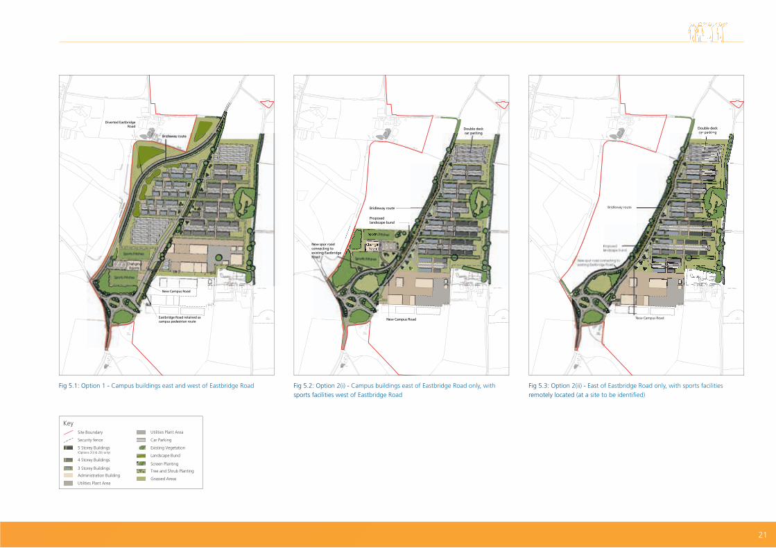
Option 1: East and west of Eastbridge Road
Option 2: East of Eastbridge Road only
Campus location
Campus east and west of Eastbridge Road. Campus on the east side of Eastbridge Road only.
Buildings Modular accommodation buildings - three storey buildings to the west and four storey buildings to the east.
Three, four and five storey modular accommodation buildings on the east side of Eastbridge Road.
Parking Single deck car parks and areas between the accommodation buildings.
Double deck car parks and areas between the accommodation buildings.
Amenities Sports pitches and related facilities - to the east of Eastbridge Road and outside the campus perimeter fence.
Option 2(i): Sports pitches and related facilities in a similar location to those proposed for campus option 1.
Option 2(ii): Facilities would be remotely located (at a site to be identified). We encourage you to provide site suggestions in your consultation response.
Access Directly off the proposed B1122 site entrance roundabout.
Directly off the proposed B1122 site entrance roundabout.
Eastbridge Road
A diversion to Eastbridge Road would allow the closed section of the existing road to be used by the workforce as a pedestrian link through the site.
Eastbridge Road would remain in use with a new link into the main development site roundabout.
We are considering two main layouts for the campus - Option 1 and Option 2. In total there are three layout options as Option 2 has sub-options - 2(i) and 2(ii) - relating to the location of the sports facilities. The accommodation campus is not expected to give rise to significant noise levels, however, Option 1 has a slightly greater potential for noise impact as it would have noise sources such as heating and ventilation equipment, car parking and recreational facilities closer to nearby homes.
Buried archaeology may be present and impacts on the setting of nearby designated heritage assets will also need to be assessed.
Appropriate mitigation measures would address any potential issues with groundwater and surface water run-off.
Options: Accommodation Campus Layout2 main options, 1 with 2 sub-options
5. Accommodation and Transport
20
Diverted Eastbridge Road
Eastbridge Road retained as campus pedestrian route
New Campus Road
Bridleway route
Sports Pitches
ChangingRooms
Sports Pitches
Fig 5.1: Option 1 - Campus buildings east and west of Eastbridge Road
New spur road connecting to existing Eastbridge Road
New Campus Road
Bridleway route
Proposed landscape bund
Double deckcar parking
Fig 5.3: Option 2(ii) - East of Eastbridge Road only, with sports facilities remotely located (at a site to be identified)
Sports Pitches
Bridleway route
New spur roadconnecting toexisting EastbridgeRoad
New Campus Road
Double deckcar parking
Changing Rooms
Sports Pitches
Proposed landscape bund
Fig 5.2: Option 2(i) - Campus buildings east of Eastbridge Road only, with sports facilities west of Eastbridge Road
Site Boundary
5 Storey Buildings (Options 2(i) & 2(ii) only)
4 Storey Buildings
3 Storey Buildings
Utilities Plant Area
Security fence
Administration Building
Car Parking
Existing Vegetation
Landscape Bund
Screen Planting
Grassed Areas
Tree and Shrub Planting
Utilities Plant Area
21

TransportIn developing our transport strategy, we have sought opportunities to limit the impact of the construction of Sizewell C on the local highway network wherever possible.
The key elements of the strategy are to:
• move material on and off the main development site by rail or sea where practical;
• build an on-site accommodation campus to reduce the number of workforce journeys;
• provide park and ride facilities at key locations on the A12 for workers to travel by bus to the main site;
• operate working patterns that minimise workers travelling at peak times;
• provide direct bus services to and from the site - such as from Ipswich and Lowestoft, with pick up services for workers using the East Suffolk rail line;
• provide local bus services from Aldeburgh and Saxmundham via Leiston;
• enhance and extend the existing network of local cycle paths; and
• provide road improvements where necessary to mitigate the impact of development.
Details of traffic modelling can be found in Section 6 of the Stage 2 Consultation Document and additional analysis will be provided at a later consultation.
We intend to consult on proposals to help mitigate significant adverse transport noise effects on residential properties. The details will be subject to further work and noise analysis.
Rail
Rail plays an important role in our strategy for delivering freight to site during the construction period.
During Stage 1 consultation, we proposed the use of an existing rail terminal south of King George’s Avenue in Leiston (‘Sizewell Halt’) for a maximum of two trains a day to support rail deliveries during the early months of construction. This remains our proposal at Stage 2.
For bringing rail freight into the site during the majority of the construction phase, we also consulted on a number of options, including a new rail terminal east of Eastlands Industrial Estate and three route options (red, green and blue) for a temporary extension of the Leiston branch line.
Further work and feedback from Stage 1 has resulted in two of the route options (red and blue) not being progressed for a number of reasons, including their potential environmental impacts, effects on the efficiency of the construction site and impact on plans to use land in Aldhurst Farm to create a new wildlife habitat.
We are now considering two rail options:
Option 1: Temporary extension of Saxmundham-Leiston branch line into the construction site - the green route
The proposals include:
• temporary closure of Buckleswood Road either side of the rail line extension during Sizewell C construction - with a diversion for cars and a new footbridge with ramped access over the railway line to retain the route for pedestrians and cyclists. The road would be reopened once the railway line has been removed;
• a level crossing where the B1122 (Abbey Road) would meet the rail extension so road users could cross safely. Each closure would last for a few minutes at most as the train passes - for a maximum of five trains (10 movements) a day at peak construction (less frequently on most days) - causing limited delays to other road users;
• moving the junction of the B1122 (Abbey Road) and Lover’s Lane approximately 100m to the south, a permanent realignment of Lover’s Lane that would improve visibility at this junction;
• the old alignment of Lover’s Lane would remain in place for cyclists and equestrians;
• diversion of footpaths to the west of the B1122;
• integration with the wider proposals for diversion of Bridleway 19; and
• during rail route construction, vehicular access to laydown area off Buckleswood Road and landscaped earthen mounds to screen development from residential properties on the opposite side of the road.
The rail extension would meet Network Rail standards.
Options: Rail proposals2 available options
5. Accommodation and Transport
22

Option 2: A new, temporary rail terminal and freight laydown east of Eastlands Industrial Estate on the eastern edge of Leiston
The proposals include:
• a railway junction east of Valley Road, from the existing Saxmundham-Leiston branch line directly into the new freight terminal;
• gantry cranes to unload containerised and bulk materials;
• small, temporary administration buildings; and
• material storage (hard standing and warehousing).
Vehicles taking material to the site would leave the rail terminal via a new road junction on Lover’s Lane, before travelling north along Lover’s Lane and turning right into a secondary site access to the west of the former District Survey Laboratory.
If this option is later discounted, we still propose to use this land to support the Sizewell C construction programme (see page 14 for more information).
Both options would incorporate retained and new landscaping to screen the proposed development from key viewpoints. Following Stage 2 consultation we will
undertake further assessments of potential environmental impacts including noise and vibration.
Discussions with Network Rail on potential upgrades to the East Suffolk line and Saxmundham-Leiston branch line are on-going (for details see Section 8 of the Stage 2 Consultation Document). Further details on any upgrades or improvements to the rail network owned and operated by Network Rail and information on any emergency proposals will be included in a later stage of consultation.
Fig 5.4: Option 1 - Illustrative route of temporary extension to Saxmundham-Leiston branch line (green route) Fig 5.5: Option 2 - Illustrative layout of new temporary rail terminal east of Eastlands Industrial Estate
Site Boundary
Interface with Main Development Site
Green Rail Route
Temporary Contractor Compound
Grassed Spoil Bund
Grassed Areas
Proposed / Existing Planting
Existing Public Right of Way (retained)Proposed Diverted Public Right of Way
Bulk Material Area
Compound
Area 1: Caravan Area Area 2: HGV Transhipment AreaArea 3: Temporary Holding Area
Topsoil Stockpile
HGV route along Lover’s Lane
Water Management Zone
Existing Rail Route
New Rail Route
Emergency Response Building
Site Boundary
Existing Public Right of Way (retained)
Proposed Diverted Public Right of Way
23

Sea transport
We are considering whether to build a temporary jetty at the main development site or use the beach landing facility (BLF), which would be built at the beginning of the construction phase as part of the coastal management, to allow construction material to be moved by sea. A BLF is already proposed for occasional use during the operational phase of the power station.
Since Stage 1, we have progressed further design work, taking account of anticipated project requirements, navigational and weather constraints and potential environmental impacts including coastal processes. Further information on the sea transport options is available in Section 7 of the Stage 2 Consultation Document.
There are three options being considered.
Option 1: Wide jetty (temporary)
Approximately 800m long, the jetty would have two berths on the north side for vessels importing bulk materials (and the potential export of excavated materials) and one berth on the south side for delivery of very large loads.
The structure supporting the jetty would be open to allow tidal flows and limit disruption to the movement of sediment. Unlike the jetty used for Sizewell B, deep water berthing would be far enough from shore to minimise the need to dredge a navigation channel, significantly reducing the impact on the shoreline and sediment supply.
The jetty would be removed at the end of the construction phase.
Fig 5.6: Option 1 - wide jetty (temporary)
Barge berths for aggregate delivery
Roll on / roll off ramp
Lift on / lift off cargo vessel berth
Options: Sea Transport3 available options
5. Accommodation and Transport
24

Option 2: Narrow jetty (temporary)
The narrower jetty would also have an open support structure and be suitable for handling abnormally large and other cargo deliveries, but could not be used to move bulk materials - either aggregates or excavated materials. The width of the structure would be reduced as the area used for conveyors would not be required and the jetty head structure would be simplified.
The jetty would be removed at the end of the construction phase.
Option 3: Beach landing facility (construction phase)
As a permanent beach landing facility (BLF) is needed for the operational phase of the power station (see page 14), it could also be used for construction phase deliveries. The BLF would be suitable for handling abnormally large deliveries but could not be used to move bulk materials - either aggregates or excavated materials.
Fig 5.7 : Option 2 - narrow jetty (temporary) Fig 5.8 : Option 3 - beach landing facility (construction phase)
Lift on / lift off cargo vessel berth
Beach landing facility location
Sizewell C
BLF access road
25

Park and ride
Further traffic modelling since Stage 1 continues to support our strategy for two park and ride facilities on the A12 to intercept traffic travelling from the south and the north.
Our Stage 2 proposals identify potential mitigation measures in response to early environmental information on our preferred park and ride sites. Following the Stage 2 consultation, further studies and assessments will be undertaken to inform the ongoing development of the proposals. These include technical surveys as well as environmental studies and assessments to inform the Environmental Impact Assessment (EIA).
Southern park and ride - Wickham Market
Following feedback from Stage 1 and further analysis, our preferred site for the southern park and ride facility is located just to the north of Wickham Market in the parish of Hacheston. The Potash Corner site (Stage 1 option) has not been taken forward due to its proximity to homes and greater potential environmental impacts. We are holding the other option proposed at Stage 1, the Woodbridge site, in reserve and it will only be brought forward and consulted on if the Wickham Market site proves unsuitable.
Following further archaeological investigation at Wickham Market, a new site boundary has been identified, to the north-east of the site consulted on at Stage 1.
The site is in the best position to reduce traffic impacts on this section of the A12. Some concerns were raised at Stage 1 about potential delays at the junction of the B1078 and B1116. Initial analysis suggests the scale of additional activity is unlikely to create any significant highway safety or congestion problems at this location. We will assess this further and discuss with Suffolk County Council as the Highways Authority.
The proposals include:
• parking for around 900 cars, bus terminus and parking, cycle stands and shelter, administration buildings, postal consolidation facility and associated infrastructure;
• buildings are likely to be single storey;
• HGV holding area for use in incident management;
• lighting that will seek to minimise potential impacts;
• a layout designed to maximise use of existing screening provided by woodland and supplementary hedgerow planting;
Fig 5.9: Indicative layout of Wickham Market park and ride
Parking (bus/car/motorcycle)
Access Road
Grassed Areas
Postal Consolidation/Amenity Buildings
Shelters (bus/cycle)
Surface Water Attenuation
Grassed Spoil Bunds
Pedestrian Walkway/Zone
Proposed / Existing Planting
Security Fence
Existing Public Right of Way (retained)
Traffic Incident ManagementArea
Site Boundary
5. Accommodation and Transport
26

• existing boundary vegetation and new planting, bunding and/or fencing would help mitigate potential visual and air quality effects. It is not currently considered that noise mitigation would be necessary but this will be reviewed following further assessment work; and
• drainage to control run-off from hard surfaces.
The induction centre proposed at Stage 1 has been relocated to the main development site.
Northern park and ride - Darsham
Following feedback from Stage 1 and further analysis, our preferred site for the northern park and ride facility is Darsham. We have not taken forward the Yoxford Road site (Stage 1 option) due to potential environmental impacts and a lack of benefits. We are holding the other option proposed at Stage 1, the A12/A144 site in reserve and it would only be brought forward and consulted on if the Darsham site proves unsuitable.
The preferred site is in close proximity to Darsham Station and would facilitate worker interchange between rail and bus. It therefore has the potential to reduce overall traffic movements compared with the other sites proposed at Stage 1.
The proposals include:
• parking for around 1,000 cars, bus terminus and parking, cycle stands and shelter, administration buildings, postal consolidation facility and associated infrastructure;
• buildings are likely to be single storey;
• lighting that will seek to minimise potential impacts;
• a 20m minimum buffer and sustainable drainage infrastructure to separate the parking area from Little Nursery woodland and nearby properties;
Fig 5.10: Indicative layout of Darsham park and ride
• existing boundary vegetation and new planting, bunding and/or fencing would help mitigate potential visual, noise and air quality effects; and
• drainage to control run-off from hard surfaces.
The induction centre proposed at Stage 1 has been relocated to the main development site.
There could also be socio-economic benefits to local businesses, for example the petrol station, shops and B&B.
Parking (bus/car/motorcycle)
Access Road
Grassed Areas
Postal Consolidation/Amenity Buildings
Shelters (bus/cycle)
Surface Water Attenuation
Grassed Spoil Bunds
Pedestrian Walkway/Zone
Proposed / Existing Planting
Security Fence
Existing Public Right of Way (retained)
Site Boundary
27

28

Lorry management
At Stage 1, we identified the potential for off-site freight management facilities. Following further investigation, we do not consider a lorry park necessary to support Sizewell C and it no longer forms part of our proposals.
Our studies show that heavy goods vehicle (HGV) deliveries and movements to and from the main development site can be effectively managed through other means, including:
• an electronic web-based Delivery Management System (DMS) to allocate HGV delivery slots and ensure compliance with agreed controls and limits. It would also allow rapid electronic communication with suppliers should deliveries need to be delayed or rescheduled due to issues on the highway network.
• use of mandatory routes for Sizewell C HGV construction traffic, enforced with the use of Automatic Number Plate Recognition (ANPR) cameras; and
• temporary holding or controlled release of HGVs from the Sizewell C site.
Road improvements
Through the investment proposed in rail and sea options, campus accommodation and park and ride facilities, we are aiming to limit the potential impacts on the local road network resulting from the construction of Sizewell C. However, we recognise that the A12 and B1122 are the most likely to be affected and a number of possible highway improvements are being considered.
Our road improvement proposals will be refined following Stage 2 consultation and more detailed information will be available at a future consultation, including a draft Travel Plan, Transport Assessment, Environmental Statement
section on transport, Traffic Incident Management Plan and Construction Traffic Management Plan.
We also intend to consult on schemes to help mitigate the effect on residential properties at a later consultation. The detail of these schemes and their eligibility criteria will be subject to further work and noise analysis.
A12
We consider that Sizewell C construction traffic may require mitigation at Farnham to improve traffic flow and safety through the narrow bend.
Following feedback from Stage 1 and further investigation, we have discounted HGV traffic controls at Farnham and are now considering four options - no change; widening the road at the Farnham bend; a one-village bypass of Farnham; or a two-village bypass of Farnham and Stratford St Andrew.
We recognise that Sizewell C traffic would exacerbate an existing problem caused by the configuration of the A12 at Farnham Bend, however proposals for highway improvements must be shown to be necessary to mitigate the impact of the Sizewell C Project and be proportionate to that impact.
A bypass around Marlesford, Little Glemham, Stratford St Andrew and Farnham cannot be justified based on traffic impacts from Sizewell C and therefore does not form part of our proposals.
Option 1: no change
The temporary increase in traffic due to Sizewell C construction may not outweigh the environmental impact of a significant intervention at Farnham. For this reason, we consider it important to seek views on whether a scenario where Sizewell C traffic would use the A12 as it currently exists might be the best approach.
Our analysis shows that many homes facing onto the A12 currently experience high levels of noise from road traffic. The Sizewell C traffic is not predicted to significantly increase noise levels or impact air quality levels along the route.
The potential for adverse environmental impacts of the ‘no change’ scenario would arise from noise and emissions from vehicles, due to the increase in traffic on the road associated with Sizewell C.
In this scenario, we would consider and consult on the use of relatively minor mitigation measures, for example, signage and the installation of noise insulation on nearby residential properties.
Options: A12 Farnham4 main options and 2 sub-options
29

Option 2: Farnham bend road widening
This option would involve widening the existing bend at Farnham to address safety concerns associated with the current narrowness of the bend. It could also improve traffic flow to some degree, but it would not remove traffic from the village.
While widening would avoid the environmental and landscape impacts of a bypass, it would require the demolition of the Grade II listed Post Office Stores building.
We recognise there would be some worsening of noise levels on the A12 through Farnham and we intend to consult at a later stage on potential mitigation, if appropriate.
Fig 5.11: Option 2: Farnham bend road widening (illustrative plan)
Temporary ContractorCompound
Access Road
Pedestrian Walkway/Zone
Site Boundary
5. Accommodation and Transport
30

Option 3: Farnham bypass (a one-village bypass)
This would reduce traffic flow through Farnham village, but would mean building a road through farmland and open countryside and a new bridge over the River Alde and floodplain. Flood compensatory storage land would be needed in the vicinity of the bypass so as not to increase existing levels of flood risk.
The proposed alignment of the bypass has been amended since Stage 1 to move it further away from the Riverside Centre, reducing the impact of the bypass on community land. We are currently proposing to integrate this existing community land with a new area of recreational and amenity space on the eastern side of the bypass on land partly occupied by the existing A12.
Two options for the bypass are being proposed with access out of Farnham village either to the north or to the west:
Option 3A, joining the A12 at Sweffling Road at a signalised junction.
Option 3B, joining the A12 at the south-western end at a T-junction.
For Option 3A, one of the possible opportunities created by the Farnham bypass is that it could allow for the closure and stopping up of the existing A12 into Farnham at the south-western end. In this option, all vehicles entering or exiting Farnham would use the signalised junction at the north-eastern end of the bypass (refer fig 5.12). The existing A12 would no longer be a through road.
Fig 5.12: Option 3A - Joining the A12 at Sweffling Road at a signalised junction (illustrative plan)
Grassed Road Embankments
Proposed / Existing Planting
Approximate Flood Compensation Areas
Existing Public Right of Way(retained)
Existing Water Courses: River / Ditches / Ponds
Grassed Areas
Temporary ContractorCompound
Bypass
31

Option 3B would retain a connection into Farnham at the south-western end and a short stretch of new connecting road would be made between Farnham and the bypass at the south-western end (refer fig 5.13). All vehicles exiting Farnham would use a priority junction connecting into the bypass.
A 30mph speed limit is proposed in the vicinity of Stratford St Andrew, rising to 50mph at the north-eastern end as it connects into the existing 50mph section of the A12.
Fig 5.13: Option 3B - Joining the A12 at the South-Western end at a T-junction (illustrative plan)
Grassed Road Embankments
Proposed / Existing Planting
Approximate Flood Compensation Areas
Existing Public Right of Way(retained)
Existing Water Courses: River / Ditches / Ponds
Grassed Areas
Temporary ContractorCompound
Bypass
Preliminary noise modelling for both options indicates a large positive noise effect for properties in Farnham given that through traffic on the existing A12 would be removed. However, there may be a small increase in noise levels for some properties located in the eastern part of Stratford St Andrew and other sites such as the recreation land/community space at the Riverside Centre.
Mitigation options could include sound absorbent road surface and screening, where necessary and technically feasible. The small increase in noise levels at some properties located in the eastern part of Stratford St Andrew could be mitigated through the provision of acoustic fencing. The need for screening will be investigated further once detailed modelling has been undertaken.
We are proposing other mitigation measures such as native tree and shrub planting on the bypass embankments for screening, appropriate lighting to minimise potential impact on neighbouring homes, a new access route under the bypass, a new area of recreational space on the eastern side of the bypass and a new footpath and cycleway.
5. Accommodation and Transport
32

Fig 5.14: Option 4: Farnham and Stratford St Andrew bypass (a two-village bypass) (illustrative plan)
Option 4: Farnham and Stratford St Andrew bypass (a two village bypass)
This option is included in response to Suffolk County Council (SCC), which has suggested that a two village bypass may be appropriate for Sizewell C. The information presented here is drawn from work commissioned by SCC to inform its proposals for a two village bypass.
The proposed new road to the south would bypass the villages of Farnham and Stratford St Andrew, forming a new section of the A12. The route would be approximately 2.4km, crossing agricultural land, floodplains and the River Alde.
Three culverts would be required where the route crosses drains, and a new bridge would be needed where it crosses the River Alde. In order to protect the river, a diversion under the bridge would be necessary. These structures have not yet been designed in detail.
Where the bypass would cross existing local roads, these would be maintained or diverted where possible. For example, a side road overbridge would be provided at the access road to Pond Barn Cottages to allow its continued use. An agricultural underpass and local connections would also be required at Farnham Hall.
Some routes would need to be diverted or closed. For example, the proposals include closure of a private road for Park Gate Farm and a private footpath and road to Foxburrow Wood.
SCC has provided some preliminary environmental information for the two village bypass proposals. This information includes an assessment of the likely environmental impacts and consideration of possible mitigation measures to address these impacts. A summary of this environmental information is included in Section 11 of the Stage 2 Consultation Document.
Grassed Road Embankments
Proposed / Existing Planting
Approximate Flood Compensation Areas
Existing Public Right of Way(retained)
Existing Water Courses: River / Ditches / Ponds
Grassed Areas
Temporary ContractorCompound
Bypass
33

Yoxford/B1122
The B1122 would experience a significant increase in traffic as a result of Sizewell C. Following a review of the B1122 and comments received during the Stage 1 consultation, we have identified a number of potential mitigation measures, including proposals to improve road safety:
1. Improvement to the junction of the B1122 with the A12 at Yoxford:
Option 1: roundabout
Option 2: signalised junction
2. Speed limit reductions on the B1122 - to a maximum of 40mph, reducing to 30mph on the approach to the main development site entrance.
3. Improvement to the B1122 to the west of the junction with Mill Street, near Middleton Moor - reducing the road level to the west of the junction would improve forward visibility for traffic on the B1122 and help traffic exiting Mill Street.
4. We have two proposals for pedestrian enhancement in Theberton:
• a pedestrian crossing and footpath near Pump Cottages including:
- the provision of a new footpath on the eastern side of the B1122 that connects to the existing footpath; and
- a new pedestrian crossing on the B1122 near Pump Cottages.
Fig 5.16: Option 2: signalised junction (indicative plan)
Fig 5.15: Option 1: roundabout (indicative plan)
Options: Yoxford Junction2 avaliable options
5. Accommodation and Transport
Pedestrian Walkway
Proposed / Existing Planting
Existing Public Right of Way(retained)
Grassed Areas
Temporary ContractorCompound
Access Road
Site Boundary
Pedestrian Walkway
Proposed / Existing Planting
Existing Public Right of Way(retained)
Grassed Areas
Temporary ContractorCompound
Access Road
Site Boundary
34

• a pedestrian path and crossing enhancement in the vicinity of the Church of St Peter, Theberton, including:
- a short section of footpath to the western side of the B1122;
- a new pedestrian crossing near to the proposed footpath enhancements; and
- minor alterations to the junction of Church Road and the B1122 to make better provision for pedestrians and reduce the speed of vehicles turning into Church Road.
5. Improvement to the alignment of the B1122 between Theberton and the main development site entrance to improve forward visibility. This would require some earthworks and loss of a small number of trees.
Speed limitreduced
to 40mph
Pedestrian crossing atPump Cottages north
of Pretty Road
Church Road pedestrianpath and crossing
improvement
Mill Street junctionimprovements
Speed limitreduced to 40mph
Speed limitreduced
to 30mph
Carriagewayalignment
improvement
Sizewell Csite entrance
Speed limit reducedto 40mph
Improvementat Yoxford
Yoxford
Westleton
Middleton
Eastbridge
B1122
B1122
B112
2
B1122
Theberton
Fig 5.17: Proposed improvements to B1122
35

Cycling
Cycling enjoys great popularity in Suffolk amongst both locals and visitors. The construction of Sizewell C and associated infrastructure represents an opportunity to enhance the cycle network in the area. We are committed to maintaining the appeal of cycling throughout the construction and operational phases of Sizewell C, as well as finding ways of encouraging new workers living in the area to travel by bicycle.
We are looking at potential upgrades to existing cycle routes as well as creating a new off-road cycle track from Sizewell Gap to the main development site entrance.
For more information on footpaths and bridleways, see page 10.
Fig 5.18: Proposed Lover’s Lane cycle route
Proposed Cycleway
Proposed Bridleway
Temporary Route
Controlled Crossing Point
Uncontrolled Crossing Point
5. Accommodation and Transport
36

37

6. Additional information
As outlined in this document, developing a new nuclear power station is a significant task and there are a number of consents and permissions required for the construction and operation of Sizewell C. In addition, there are other elements that, although not part of this consultation, provide useful context.
UK EPRTM technology
The Sizewell C site would include two reactors, known as UK EPRTM, capable of generating enough electricity to supply approximately six million homes in Britain.
The design of the UK EPRTM is based on pressurised water reactor (PWR) technology that has been used successfully and safely around the world for many years. EDF already runs 58 PWRs in France, as well as Sizewell B in Suffolk, and there are 277 successfully operating around the world. The UK EPRTM represents a major development on previous PWRs making them amongst the safest and most efficient civil nuclear power generators ever designed.
Sizewell C would be part of the EPR family, benefiting from the experience of other EPRs currently being built, including at Flamanville in France and Taishan in China, whilst construction has begun at Hinkley Point C in Somerset.
The UK EPRTM underwent a Generic Design Assessment (GDA) process, which concluded when the Office for Nuclear Regulation (ONR) issued a Design Acceptance Confirmation (DAC) and the Environment Agency issued a Statement of Design Acceptability (SoDA) in December 2012. For more information on GDA see: www.hse.gov.uk/newreactors.
Fig 6.1: EPR nuclear power plant
38

Safety
We make safety our overriding priority. Nuclear power is one of the most rigorously regulated industries in the UK. In addition to the Development Consent Order, In order to construct and operate Sizewell C we would require a nuclear site licence from the ONR and environmental permits from the Environment Agency as well as the development consent order.
Fuel and waste
The design of the UK EPRTM makes more efficient use of nuclear fuel than current reactor designs, reducing the amount of spent fuel produced. The spent fuel and intermediate level radioactive waste would be kept on-site until a national geological disposal facility becomes available.
Low-level waste would be treated on-site to limit its volume and, after appropriate conditioning and packaging, it would be removed for disposal.
Decommissioning
At the end of its electricity generation, Sizewell C would be decommissioned in a process likely to take about 20 years. However, the interim spent fuel store would continue to operate until a national geological disposal facility is available and the spent fuel is ready for disposal.
Wildlife habitat creation
We have created a new wildlife habitat at Aldhurst Farm, outside Leiston, to benefit both people and wildlife and help compensate for any future potential land-take from the Sizewell Marshes Site of Special Scientific Interest (SSSI). Suffolk Coastal District Council granted planning permission for this in March 2015 following a period of public consultation.
The 67-hectare site has been converted into a new wetland habitat that will benefit a variety of wildlife including water voles, otters, eels, amphibians, reptiles and birds, as well as rare plants.
In addition to Aldhurst Farm we are creating heath and grassland south of Sandy Lane in order to establish suitable habitat for reptiles that would need to be removed from the development site before construction begins.
The location of these environmental schemes are shown in fig 3.2.
Visitor centre
Three potential sites for a visitor centre - open to the public, with exhibition space and modern facilities for school groups - were proposed at Stage 1 consultation.
The principle of a new visitor centre remains part of our proposals and, together with Sizewell B, we are continuing to consider location and design of a centre for the Sizewell power station complex. We will consult on the siting of a visitor centre prior to an application being submitted.
Purchase of land
To enable Sizewell C to go ahead, we would need to make use of some land outside the EDF Energy Sizewell Estate - temporarily or permanently - for construction activities as well as associated development.
We are committed to acquiring the rights to use this land through private negotiations. We have already identified the land we would wish to use for our current proposals and have contacted the owners. Should it not be possible to reach agreement to acquire land by private treaty, we will apply for powers of compulsory purchase or rights of access as part of our application for development consent.
If you believe you have a legal interest in any of the land required for our proposals and have not been approached by our agents, please contact us by one of the means listed on page 40.
39

7. Next steps
Responding to the consultation
We are keen to hear from you during Stage 2 Consultation and are seeking your views on all aspects of our Stage 2 strategies and proposals. We encourage you to comment on:
• our overall proposals for the Sizewell C nuclear power station, whether presented as options or preferred proposals;
• the associated development needed to support the construction and operation of the power station; and
• the potential effects of the Project, both positive and negative - and proposed mitigation measures where appropriate.
We encourage you to provide feedback in one of the following ways:
Copies of all the consultation documents are available in hard copy and on disc at the exhibitions and at the Sizewell C Information office, open from 9.30am-5pm Monday - Friday and 9am-12pm Saturday (48-50 High Street, Leiston, IP16 4EW). They will also be available to view during normal office hours, in the offices of Suffolk County, Suffolk Coastal District, Waveney District and Ipswich Borough Councils and at a number of local public libraries. They are also available on the Project website: www.sizewellc.co.uk.
If you require the consultation information in a different format for accessibility reasons, please call (0800 197 6102) or email ([email protected]).
Please remember that the deadline for responses to Stage 2 of our consultation is 3 February 2017.
What next
Following review of feedback from the Stage 2 Consultation, we will continue to develop our strategies and proposals and undertake further assessment work.
At a later stage of consultation, we will set out the details of the preferred proposals for Sizewell C and provide details of the information and assessments that have informed them. Later consultation will also include more detail and preliminary environmental information (PEI), including the findings of initial impact assessments. If necessary we will also undertake limited, focused stages of consultation if specific issues or changes arise. Any further stages of consultation will be promoted in advance.
Following the pre-application consultation, we will submit an application for development consent to the Planning Inspectorate. The application will comprise a suite of documents, including a Consultation Report that details the engagement and consultation undertaken, responses to the issues raised and how the consultation has influenced the final proposals.
Call our Freephone number during normal office hours: 0800 197 6102
Email your comments to: [email protected].
Post your written responses to FREEPOST SZC Consultation(no stamp or further address required)
Complete a questionnaire: Online www.sizewellc.co.ukOr in hard copy and post it to our freepost address (see below)
40

41
8. Questionnaire

If you need help to understand this information in another language please call 0800 197 6102.
PortugueseSe precisar de ajuda para ler estas informações em outra língua, por favor telefone para o número abaixo 0800 197 6102.
PolishJeżeli potrzebujesz pomocy w zrozumieniu tych informacji w swoim języku zaadzwoń na podany poniżej numer 0800 197 6102.
Bengali 0800 197 6102.
LithuanianJeigu jums reikia sios informacijos kita kalba, paskambinkite 0800 197 6102.
RomanianDacă aveți nevoie de ajutor pentru a înțelege această informație într-o altă limbă, vă rugăm să telefonați la numărul 0800 197 6102.
If you would like this information in another format, including audio or large print, please call 0800 197 6102.
edfenergy.com
EDF Energy Ltd 40 Grosvenor Place London SW1X 7EN
Registered in England and Wales. Company registration number 2366852
© Copyright EDF Energy All rights reserved 2016