Embed Size (px)
Citation preview

Consultation Responses on the review of MGN 543 and Methodology for Assessing the Navigational Safety and Emergency Response of Offshore Renewable Energy Installations.
In response to the consultation carried out between 20 January 2020 to 13 April 2020, MCA received responses from 22 stakeholders from harbour authorities, commercial shipping, recreation, fishing, navigation consultants, Government departments, General Lighthouse Authority and offshore renewable energy developers. Comments and MCA response were as follows: MGN543 Safety of Navigation: Offshore Renewable Energy Installations (OREIs) - Guidance on UK Navigational Practice, Safety and Emergency Response.
Stakeholder Section Stakeholder Comment MCA Response
1 General We have recently experienced a situation where a recently constructed Windfarm laid a power export cable which was meant to be buried below the seabed with varying depths of burial dependant on the geology in the area. Upon completion it was discovered that many linear kilometres of cable had not been buried at all or had not met the agreed depths of burial. The operator of the Windfarm insisted that no further attempts for burial would be made. The operator of the Windfarm had the cable route independently risk assessed prior to construction which resulted in the required burial depths. The operator of the Windfarm had the cable route independently risk assessed post construction which resulted in acceptance of all cables regardless of burial depth. At that time 3 port authorities worked together in a 2 year legal dispute to ensure the safety of navigation in the area. We believe that it is essential, for the matter of navigational safety that all areas of an OREI should be considered which most certainly should include export cables.
This issue is addressed by the conditions of licence and the process by which the risk to the safety of navigation is assessed by MCA and other stakeholders: b) a detailed cable laying plan for the Order limits, incorporating a burial risk assessment encompassing the identification of any cable protection that exceeds 5% of navigable depth referenced to chart datum and, in the event that any area of cable protection exceeding 5% of navigable depth is identified, details of any steps (to be determined following consultation with the MCA and Trinity House) to be taken to ensure existing and future safe navigation is not compromised or such similar assessment to ascertain suitable burial depths and cable laying techniques, including cable protection; and c) proposals for monitoring offshore cables including cable protection during the operational lifetime of the authorised scheme which includes a risk based approach to the management of unburied or shallow buried cables. This is addressed in section 6.7.

Stakeholder Section Stakeholder Comment MCA Response
2 4.5 Poor recreational boating data: The RYA has noted limited inclusion of recreational boating activity data in the NRA due to over reliance on AIS data. The RYA estimate that 30% of all recreational craft up to 24m in length have AIS fitted, as it is cheaper and easier to use than radar. AIS is valuable for showing where recreational routes are, but not necessarily high recreational use areas, where small craft are not fitted with AIS. The RYA welcome the wording of section 4.5 of MGN 543, and agree that AIS data alone should not “constitute an appropriate traffic survey” (Section 4.5 a, MGN 543). In previous consultations with developers we have, however, noted a reluctance for developers to recognise RYA Boating Areas. We therefore recommend that: Recommendation 5: a. Section 4.5 of MGN 543 should be revised to include interviews/ questionnaire based information gathering from recreational users, boat clubs, training centres, harbours, etc. (and their representative organisations) to augment traffic surveys, and; b. It should be noted that the RYA Coastal Atlas GIS has gathered data using both AIS and information from our member clubs and training centres, as a result our boating area information should be given the same weighting as other traffic survey methods in Section 4.5a of MGN 543.
MCA recognise that not all vessels carry AIS and expect developers to consider a range of options to ensure recreational craft and non AIS vessels are adequately addressed to demonstrate a true refection of the marine environment. Amended to say other sources can be used in consultation with MCA to reflect local traffic.

Stakeholder Section Stakeholder Comment MCA Response
Insufficient Information for licensing decisions: The RYA notes the submission of licensing applications relying on future assessments following the granting of the licence. This prevents consideration of all potential impacts before approval. The RYA considers that a particular problem exists where licence applications, submitted for proposals using submerged devices with appropriate Under Keel Clearances (UKC), are then modified after the NRA is completed, to include surface or surface piercing technology on the basis that mitigation will be provided by some form of future assessment. It is the RYA view that this approach undermines the ability to undertake an accurate NRA in accordance with Section 4.7 of MGN 543. Recommendation 6: Section 4.7 of MGN 543 should state that licence applications can only be made for a development that has a completed assessment (ES and NRA) of all technologies to be used. Where there is a future variation in technology, that has not been assessed, then it should be subject to a new licence application, ES and NRA.
Any changes to the project specifications after ES/NRA has been submitted and consent will require a licence variation and ML authorities will consult stakeholders. A NRA update may be required and future technologies can be assessed then. 4.1 amended to include "Any substantial changes to the project that impacts on shipping and navigation may require relevant NRA updates."

Stakeholder Section Stakeholder Comment MCA Response
The Rochdale Envelope: Linked to the problems of insufficient information, see Recommendation 6, the RYA note that the Rochdale Envelop approach (originally developed for terrestrial projects) is being applied to marine development EIA/ ES. We further note that the assumptions/ objectives frameworks used in the approach can be changed following consultation, undermining the accuracy of the EIA/ ES and NRA. It is the RYA view that there should be a presumption against the application of the Rochdale Envelope to marine OREI developments as the variation in types of structure (surface, submerged, surface piercing, etc.) produce such a variation in UKC and minimum safe air clearances as to render any NRA or ES useless for decision making. Recommendation 7: The RYA recommend that: a. Clear guidance is produced by the MCA on the application of the Rochdale Envelop to marine projects in Section 4.7 of MGN 543 and Section 2.4 of the NRA Methodology, and; b. That both MGN 543 and the NRA Methodology clearly state that assumptions, particularly those that impact on maritime safety, are established at scoping/ screening stage and are not varied unless the change is communicated to stakeholders to ensure their views are accurately reflected within the final NRA and ES.
Guidance on the application of the Rochdale Envelope is provided by The Planning Inspectorate as it applies in the EIA process.
3 6.4 Two questions almost always arise in relation to ID sign lights: 1) Do ID sign lights need to be monitored? 2) Do ID sign lights need 96h battery backup? We have seen different interpretations across different wind farms in the UK, some have both of the above, some have neither. Note that GLAs generally state that it is within the MCAs responsibility to decide this, not theirs, hence I understand this to be right place to clarify this. As per IALA O-139 section 2.3 ID signs and lights are listed as recommended. Our interpretation is that IALA recognises it as a NavAids and therefore should be treated as such. Hence ID sign lights should be monitored, controller and battery backed up the same way as a marine lantern.
There is no MCA requirements to monitor these or back up. They should be hooded/baffled to avoid any light pollution.
Stakeholder Section Stakeholder Comment MCA Response
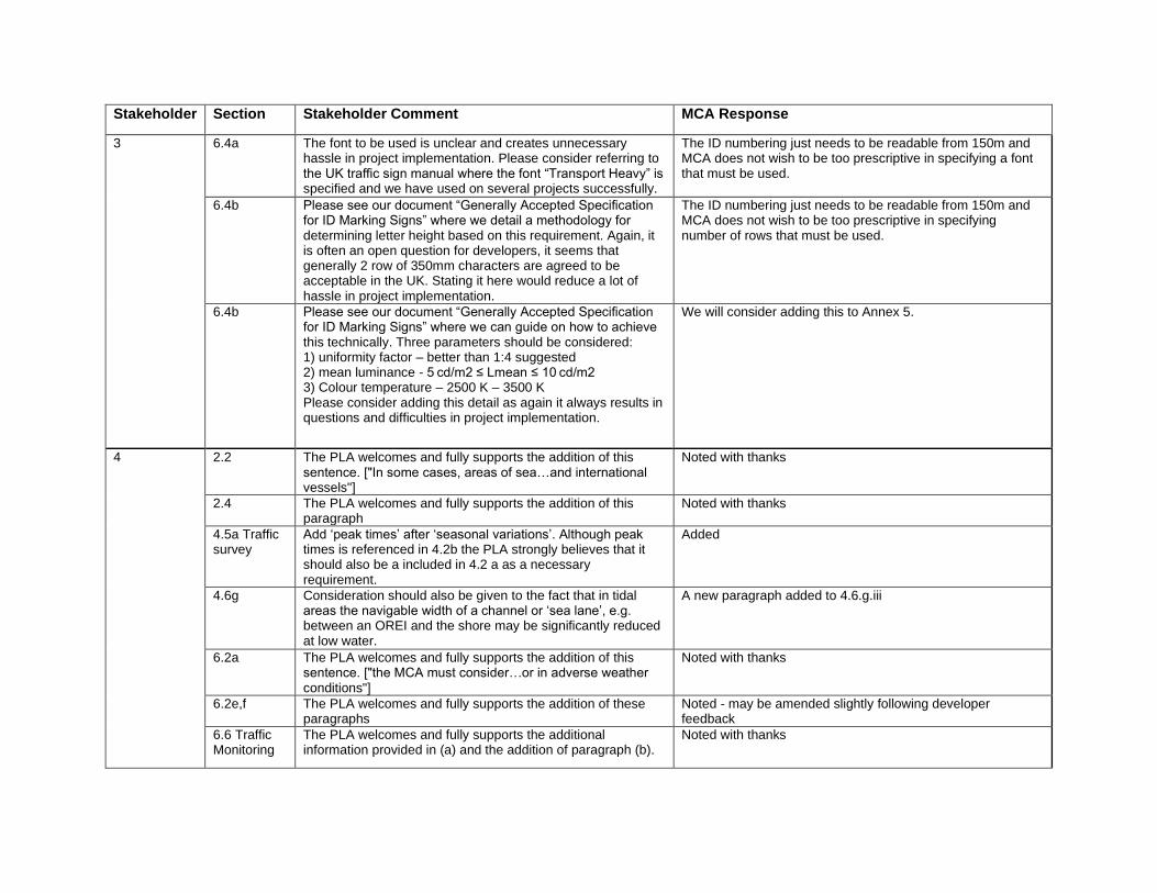
3 6.4a The font to be used is unclear and creates unnecessary hassle in project implementation. Please consider referring to the UK traffic sign manual where the font “Transport Heavy” is specified and we have used on several projects successfully.
The ID numbering just needs to be readable from 150m and MCA does not wish to be too prescriptive in specifying a font that must be used.
6.4b Please see our document “Generally Accepted Specification for ID Marking Signs” where we detail a methodology for determining letter height based on this requirement. Again, it is often an open question for developers, it seems that generally 2 row of 350mm characters are agreed to be acceptable in the UK. Stating it here would reduce a lot of hassle in project implementation.
The ID numbering just needs to be readable from 150m and MCA does not wish to be too prescriptive in specifying number of rows that must be used.
6.4b Please see our document “Generally Accepted Specification for ID Marking Signs” where we can guide on how to achieve this technically. Three parameters should be considered: 1) uniformity factor – better than 1:4 suggested 2) mean luminance - 5 cd/m2 ≤ Lmean ≤ 10 cd/m2 3) Colour temperature – 2500 K – 3500 K Please consider adding this detail as again it always results in questions and difficulties in project implementation.
We will consider adding this to Annex 5.
4 2.2 The PLA welcomes and fully supports the addition of this sentence. ["In some cases, areas of sea…and international vessels"]
Noted with thanks
2.4 The PLA welcomes and fully supports the addition of this paragraph
Noted with thanks
4.5a Traffic survey
Add ‘peak times’ after ‘seasonal variations’. Although peak times is referenced in 4.2b the PLA strongly believes that it should also be a included in 4.2 a as a necessary requirement.
Added
4.6g Consideration should also be given to the fact that in tidal areas the navigable width of a channel or ‘sea lane’, e.g. between an OREI and the shore may be significantly reduced at low water.
A new paragraph added to 4.6.g.iii
6.2a The PLA welcomes and fully supports the addition of this sentence. ["the MCA must consider…or in adverse weather conditions"]
Noted with thanks
6.2e,f The PLA welcomes and fully supports the addition of these paragraphs
Noted - may be amended slightly following developer feedback
6.6 Traffic Monitoring
The PLA welcomes and fully supports the additional information provided in (a) and the addition of paragraph (b).
Noted with thanks

Stakeholder Section Stakeholder Comment MCA Response
4 Annex 2 Interactive Boundaries
A lot of useful information on this subject is contained in the Guide to Marine Spatial Planning, some of which is already incorporated into this Annex. Could reference be made, or a link provided to this document? https://www.nautinst.org/uploads/assets/uploaded/299f934f-ee69-492e-8ada51abf26e8b19.pdf
Added as a footnote
5 Overall The Methodology could be more aligned with the content of the MGN 543, to ensure users are aware of the purpose of both documents and how they are expected to be used together to undertake a Navigation Safety Risk Assessment.
Footnotes added pointing to relevant Annexes of the Methodology
4.4 The Checklist should be completely revised to the new paragraphing of the MGN and included as an Annex rather than a separate document. Should the SAR checklist also be included as an Annex?
MGN checklist added as Annex 6 and will be updated when MGN is finalised. The SAR Checklist is a separate document referenced in Annex 5.
Annex 6 Checklist should only need to include paragraphs 4.5 to 4.14 paragraph 5 and paragraphs 6 to 6.9 and perhaps paragraph 7 to make the checklist user friendly.
The Checklist will be revised
4.5a Should requirements for data collection for surface structures outside of the array and the export cable corridor be included.
This can be discussed with MCA before survey.
- There should be a clearer distinction between corridor widths (within a development) and shipping routes (external to a development).
These are assessed on a case by case basis.
- Guidance should also be tidied up to make sure multiple methods of calculation are not included for the same measurement i.e. Annex 2 Shipping Template: Remove the reference to minimum/preferred distances to parallel boundary of an IMO routeing measure, as this conflicts with paragraph 4.5 (d) (vii).
It was not considered necessary to remove the reference to minimum distance in Annex 2. Paragraph 4.5.d.vii does appear to be a duplication of iv and v, so vii removed.
Annex 2 not showing correctly as a track change. There should also be some discussion / reasoning here why this has been reverted in the majority back to that which was included in MGN 371 given that experience has shown that these parameters are to an extent arbitrary and were formed without a technical basis. As above it also conflicts with other guidance.
Experience of the simplified version in MGN543 showed that it was being used too literally by some developers e.g. some OREIs were automatically sited 0.5nm away without indication of level of risk. It was felt the inclusion of the additional information on the effects to vessels would be useful guidance. The Tolerability bandings have been amended to ensure it is the same with the current version.

Stakeholder Section Stakeholder Comment MCA Response
6 1a The mandate and objective of MGN 543 is not clear, in that the note is a mixture of policy considerations, various assessment methodologies (often with little or no evidential backing) and ambiguous guidance. For example, Annex 2 provides an incomplete, and unreferenced methodology for the assessment of shipping routes and the determination of buffer distances between undefined routes and OREIs.
The objective of the guidance is clearly stated on the opening page in the Summary. The sentence below the Annex 2 table states that it is not a prescriptive tool and that acceptance of distances is dealt with on a case by case basis. The table was introduced in MGN 371 and amended on agreement with navigation stakeholders through the NOREL TWG.
1b In addition, the MGN is related to all OREIs, yet almost all guidance and examples relate to wind farms. Are the same requirements held for tidal, wave, meteorological masts and other developments?
Yes. Reference to the guidance applying to wind, wave and tide is made in the Summary
1c The Maritime Coastguard Agency are referred to as the statutory consultee and primary advisor to the licensing authorities, who specifically this is should be defined e.g. Navigational Safety Branch?
Reference to MCA being the statutory consultee and primary advisor reflects the legislation and guidance published by the licensing and consenting authorities. Paragraph 2.5 amended to confirm this is through NSB
1d It is proposed that the MGN provides guidance only, on the necessary requirements for the assessment of navigation safety for OREI, and that the accompanying Methodology document provides example methodologies.
The MGN states is it guidance in the Summary. The Methodology document recommends FSA but developers may use another methodology with justification.
Definitions 2a
Much of the MGN relates to the assessment of navigation risk, though definitions of risk are not provided, and neither are “Tolerability” or “Acceptability” levels provided, that enable developers to ascertain whether their proposals can be determined as “safe”. The notes mix’s up definitions such as “risk”, “risks” and “hazards”, with no clear definition of each of these terms.
The MGN should be read in conjunction with the Methodology document where these are described.
2b At various points, MGN543 discusses sea lanes, sea routes and shipping routes. None of these are defined and are used interchangeably. Definitions based on the frequency of transit are recommended to differentiate the significance of different types of route.
Difficult to define in terms of number of transits as there may be other factors that diffrentiate the significance of a route e.g. less frequent ferry or supply routes.

Stakeholder Section Stakeholder Comment MCA Response
6
Traffic Survey 3a
In conducting a NRA for a OREI the MGN quite rightly advises on the need to conduct a Vessel Traffic Survey, which should include Radar, AIS and visual observations. The Vessel Traffic Survey is frequently the costliest item of a NRA and commonly requires the procurement of a vessel to conduct the survey. The specifications of the Vessel Traffic Survey within the MGN are cursory. The basis of any evidential assessment is the quality and validity of the underlying data it is based on and therefore the specification of the Vessel Traffic Survey is critical.
The requirements for traffic survey have been in place since MGN 275 (published in 2004) so we do not consider them 'cursory'. Subsequent amendments were agreed as appropriate with navigation stakeholders at NOREL and its TWG.
3b This is exacerbated by future Round 4 developments, with significant footprints at great distance from shore. It would be effectively impossible to achieve full radar coverage of a site PLUS a buffer area (which isn’t defined), in all weather conditions. NASH are aware of a number of NRAs where radar coverage of the project footprint was not possible, but this was not seen to impact upon the NRA when submitted as part of the EIA. Greater clarity on the quality and scope expected of a Vessel Traffic Survey is needed.
Developers are encouraged to discuss the survey plans with MCA prior to conducting the survey.
3c It is therefore essential that more detailed specifications and guidance is provided on the: i. Definition of geographical survey coverage requirement. ii. Radar used for the survey (including calculation of radar range by target size and sea state to ensure coverage of the survey area). iii. AIS used for the survey (including calculation on the AIS range to ensure coverage). iv. Details on the vessel characteristics to ensure the vessel traffic survey watch keepers can adequately cover the survey area.
Developers are encouraged to discuss the survey plans with MCA prior to conducting the survey.
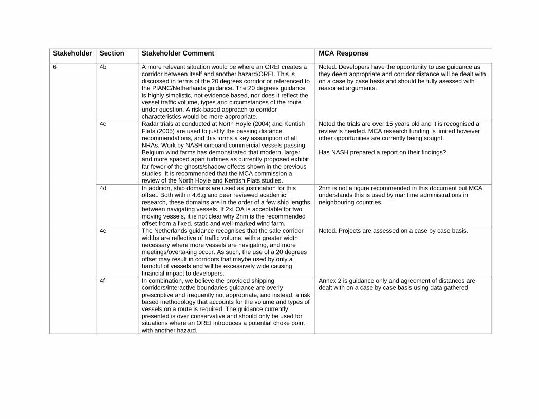
Shipping Corridors/ Interactive Boundaries 4a
Much of Section 4.6 and Annex 2 discuss the relationship between turbine boundaries and shipping routes, however the purpose of the Annex 2 template is unclear. Where a development is proposed, shipping routes may be deviated as prudent mariners maintain a safety buffer to the obstruction. Therefore, the distance vessels choose to pass is driven by the master, and previous evidence of constructed offshore wind farms show that this can be <1km1 and for surface tidal devices in Orkney, <200m. Therefore, if during the NRA the analyst models the passing distance at a safe, but unrealistic, 3nm passing distance, the risk scores are low, but there is a relatively larger impact on route diversion.
Annex 2 is guidance only and agreement of distance are dealt with on a case by case basis using data gathered
Stakeholder Section Stakeholder Comment MCA Response
6
4b A more relevant situation would be where an OREI creates a corridor between itself and another hazard/OREI. This is discussed in terms of the 20 degrees corridor or referenced to the PIANC/Netherlands guidance. The 20 degrees guidance is highly simplistic, not evidence based, nor does it reflect the vessel traffic volume, types and circumstances of the route under question. A risk-based approach to corridor characteristics would be more appropriate.
Noted. Developers have the opportunity to use guidance as they deem appropriate and corridor distance will be dealt with on a case by case basis and should be fully asessed with reasoned arguments.
4c Radar trials at conducted at North Hoyle (2004) and Kentish Flats (2005) are used to justify the passing distance recommendations, and this forms a key assumption of all NRAs. Work by NASH onboard commercial vessels passing Belgium wind farms has demonstrated that modern, larger and more spaced apart turbines as currently proposed exhibit far fewer of the ghosts/shadow effects shown in the previous studies. It is recommended that the MCA commission a review of the North Hoyle and Kentish Flats studies.
Noted the trials are over 15 years old and it is recognised a review is needed. MCA research funding is limited however other opportunities are currently being sought. Has NASH prepared a report on their findings?
4d In addition, ship domains are used as justification for this offset. Both within 4.6.g and peer reviewed academic research, these domains are in the order of a few ship lengths between navigating vessels. If 2xLOA is acceptable for two moving vessels, it is not clear why 2nm is the recommended offset from a fixed, static and well-marked wind farm.
2nm is not a figure recommended in this document but MCA understands this is used by maritime administrations in neighbouring countries.
4e The Netherlands guidance recognises that the safe corridor widths are reflective of traffic volume, with a greater width necessary where more vessels are navigating, and more meetings/overtaking occur. As such, the use of a 20 degrees offset may result in corridors that maybe used by only a handful of vessels and will be excessively wide causing financial impact to developers.
Noted. Projects are assessed on a case by case basis.
4f In combination, we believe the provided shipping corridors/interactive boundaries guidance are overly prescriptive and frequently not appropriate, and instead, a risk based methodology that accounts for the volume and types of vessels on a route is required. The guidance currently presented is over conservative and should only be used for situations where an OREI introduces a potential choke point with another hazard.
Annex 2 is guidance only and agreement of distances are dealt with on a case by case basis using data gathered
Stakeholder Section Stakeholder Comment MCA Response
6 Layout Design 7a
This revision has introduced the requirement for two lines of orientation within OREI site. No justification is provided as to why a single line of orientation is not sufficient within an OREI site, but no restrictions are placed for example on oil and gas infrastructure.
Two lines of orientation was introduced in MGN 543 in 2016 which was agreed through NOREL. It is not considered appropriate to compare OREI layout to oil and gas infrastructure - these are often single structures and not arrays.
7b Prior to grant of DCO, NRAs are conducted on the Rochdale Envelope Red Line Boundary approach and turbine layouts are not known. Section 6.2 discusses the need for the NRA to address the safety of the proposed layout, yet this is frequency not possible at DCO stage. This requirement seems to mandate an additional NRA post-consent in order to finalise the site layout.
Section 6.2 of the proposed MGN version refers to the post-consent stage. An additional NRA is not required, however if a safety justification is submitted the NRA will be used as part of it.
Commercial Impacts 8a
The NPS EN3 requires that impacts to shipping be assessed, and links it to ALARP level risk and differing shipping lanes. Whilst not specifically mentioned in the MGN, it is noted that the EIA chapter should address all impacts related to Shipping and Navigation, and this includes commercial impacts that might include increased transit distance.
A chapter addressing commercial impacts should be included in the EIA Report and it should be noted that MCA does not normally assess this chapter.
8b No guidance is provided on how to assess increased transit distance. For example, it might be demonstrated than an OREI increases transit distance for 1,000 vessels a year by 5nm – but there is no method to determining whether this is “Significant” in EIA terms. For vessels on 5,000nm journeys this could be compensated for in passage planning to arrive at the same time, but for a ferry route this would likely be a significant impact on timetabling.
Commercial impacts lies outside the scope of the MGN and Methodology document
8c The MGN and/or the Methodology Document should recognise impacts in addition to safety and provide guidance on acceptable assessment methods to evaluate them.
Commercial impacts lies outside the scope of the MGN and Methodology document
Summary 1
MCA to provide a risk assessment template for developers to utilise that standardises definitions of hazards, assessment bandings (likelihood/consequence), units of measurement and acceptability / tolerability – this could be through the adoption of international standards such as the IALA Risk Management Guidance and associated Tool Kits. This would ensure consistency and transparency between the assessment process between different developments.
It is not recommended within FSA to provide specific numerical values for assessment bandings and tolerability since it can vary according to perspective, proportionality (e.g. QRA may not always be appropriate) and the type of site-specific activity. There is no criterion in IMO to determine acceptability and HSE notes that quantitative unacceptable limits are used with caution due to their complexity and the quantative predictions might be compared to are frought with uncertainty. If a risk falls below a numerical value then it does not necessarily mean ALARP - further reductions may be possible.

Stakeholder Section Stakeholder Comment MCA Response
6 2 MCA to develop repository of supporting studies that can be used by developers. For example, work on SAR, radar, lessons learnt from previous assessments and analyses of the impacts of previous developments on shipping would greatly aid the assessment process. Many of these documents exist but are not clearly listed and are also often out of date, require updating – this would support the OREI industry.
A repository exists on the MCA website: https://www.gov.uk/guidance/offshore-renewable-energy-installations-impact-on-shipping. This page will be updated following the publication of the MGN.
3 Greater appreciation of uncertainty in NRAs. The MCA should insist on self-declaration within NRAs as to where uncertainties have been identified and mitigated. For example, uncertainties in data collection, future traffic projections, model assumptions, hazard likelihood scores and cumulative developments all have a significant impact upon the outcomes of the NRA but are rarely reflected or discussed. Insisting for greater transparency within the NRA would support stakeholder buy-in and more productive technical discussions that enhance the assessment of risk.
This is addressed in the Methodology documents Annexes D and F.
7 Track changes
Comments and amendments in the MGN document using Track Changes
Noted
In the introductory summary, mention is made of the navigational safety and emergency response. Emergency response includes counter pollution, but It was felt that counter pollution was not sufficiently dealt with in the guidance note. There has been some discussion recently between MCA and MS about respective regulatory responsibilities over pollution. Whilst MS considered that there is some need for regulatory coverage from the licensing and consenting authority on behalf of Scottish ministers, in relation to pollution from structures, it appears that all vessel related pollution would be the responsibility of the MCA. If MCA guidance can clarify the MCA’s regulatory responsibility over spillages from work vessels and jack up vessels during construction and maintenance activities, that would greatly help the sector’s understanding and reduce the risk of double regulation and risk undermining anything in your statutory responsibility.
This will be considered in the next review of Annex 5

Stakeholder Section Stakeholder Comment MCA Response
7 3 Environmental Impact Assessment Regulations – It would be useful to state how this document was relating to EIA regulations in particular how stages like screening, scoping, EIA Report and post consent conditions fit in with what developers are required to do at the different stages. This could be put alongside the breakdown of the development at section 3.6. It would also be useful throughout the document to have this linkage and identify the requirements according to these stages. It was also noted throughout the document the reference to Environmental Statement, which is now outdated, rather than EIA Report.
Reference to 'ES' amended to 'EIA Report'
2 Legislation section 2 and elsewhere make reference to s36 b coming from the Energy Act 2004 the primary legislation is actually the Electricity Act 1989, the Energy Act merely introduces the amendment to the Electricity Act. It would also be beneficial to include reference in Section 2 to the main aspects of the Energy Act 2004, namely safety zones (s.95) and decommissioning (s.105). It would perhaps be useful for MCA to have a legal review at the conclusion of this consultation process
Amended to confirm s.36B of the Electricity Act 1989. Safety Zones are mentioned under paragraph 4.14 and 4.14b amended to confirm they are granted under s.95 of the Energy Act. Paragraph 7 confirms legislation for decommissioning.
- Safety Zones MCA is consulted on the establishment of safety zones (s.95 Energy Act 2004). Could any clear policies of the MCA in relation to safety zones be included in this guidance to reduce numbers of consultation processes?
MCA has shared minutes of a NOREL TWG in May 2019 where MCA's position on safety zones is explained.
- Consent conditions There is a need to review Marine Scotland’s consent conditions with respect to MCA requirements in line with MGN 543 in order to ensure compliance whilst avoiding duplication of regulatory functions..
Noted
8 It is suggested that guidance is provided on assessing any changes in navigable water depths as a result of the use of moorings on OREI’s.
This is captured in the hydrographic survey guidance in Annex 4.
Stakeholder Section Stakeholder Comment MCA Response
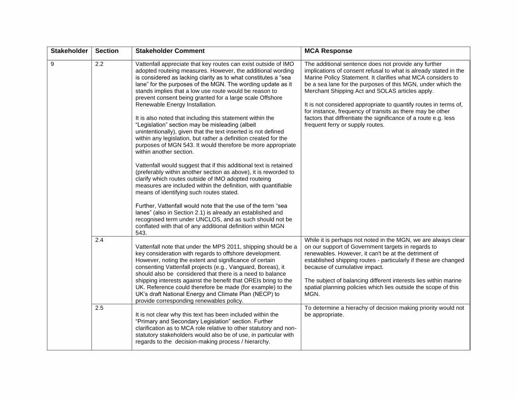
9 2.2 Vattenfall appreciate that key routes can exist outside of IMO adopted routeing measures. However, the additional wording is considered as lacking clarity as to what constitutes a “sea lane” for the purposes of the MGN. The wording update as it stands implies that a low use route would be reason to prevent consent being granted for a large scale Offshore Renewable Energy Installation. It is also noted that including this statement within the “Legislation” section may be misleading (albeit unintentionally), given that the text inserted is not defined within any legislation, but rather a definition created for the purposes of MGN 543. It would therefore be more appropriate within another section. Vattenfall would suggest that if this additional text is retained (preferably within another section as above), it is reworded to clarify which routes outside of IMO adopted routeing measures are included within the definition, with quantifiable means of identifying such routes stated. Further, Vattenfall would note that the use of the term “sea lanes” (also in Section 2.1) is already an established and recognised term under UNCLOS, and as such should not be conflated with that of any additional definition within MGN 543.
The additional sentence does not provide any further implications of consent refusal to what is already stated in the Marine Policy Statement. It clarifies what MCA considers to be a sea lane for the purposes of this MGN, under which the Merchant Shipping Act and SOLAS articles apply. It is not considered appropriate to quantify routes in terms of, for instance, frequency of transits as there may be other factors that diffrentiate the significance of a route e.g. less frequent ferry or supply routes.
2.4 Vattenfall note that under the MPS 2011, shipping should be a key consideration with regards to offshore development. However, noting the extent and significance of certain consenting Vattenfall projects (e.g., Vanguard, Boreas), it should also be considered that there is a need to balance shipping interests against the benefit that OREIs bring to the UK. Reference could therefore be made (for example) to the UK’s draft National Energy and Climate Plan (NECP) to provide corresponding renewables policy.
While it is perhaps not noted in the MGN, we are always clear on our support of Government targets in regards to renewables. However, it can't be at the detriment of established shipping routes - particularly if these are changed because of cumulative impact. The subject of balancing different interests lies within marine spatial planning policies which lies outside the scope of this MGN.
2.5 It is not clear why this text has been included within the “Primary and Secondary Legislation” section. Further clarification as to MCA role relative to other statutory and non-statutory stakeholders would also be of use, in particular with regards to the decision-making process / hierarchy.
To determine a hierachy of decision making priority would not be appropriate.

Stakeholder Section Stakeholder Comment MCA Response
9 3.1 Vattenfall are unclear as to why the “Whilst not mandatory” wording has been removed. If MCA position has changed then this should be stated.
It was considered redundant given the nature of the MGN and use of 'may' throughout the paragraph.
4.5a/b In relation to the removal of the “if deemed necessary” wording, Vattenfall would observe that long term surveys that are inclusive of radar and visual observation data in addition to AIS are not easy to implement, and would pose certain risks when undertaken at developments further offshore. It is not clear from the wording when the MCA would expect the 28 day period to be insufficient, or if such long terms surveys would be expected to include non-AIS data, and Vattenfall would therefore suggest that additional clarity is necessary. Any increase in survey duration should only be considered where it is demonstrated to be necessary. It is also observed that given the increased comprehensiveness of AIS carriage / broadcast, in certain circumstances an AIS only survey may be appropriate and suitable. It is therefore suggested that this wording is adapted to accommodate flexibility in this regard, noting specific survey requirements would still obviously need to be agreed with the MCA on a case by case basis. It is also considered reasonable for more clarity to be added here as to the requirements for export cable corridors or other NRAs for other devices whereby Radar data collection is not appropriate nor is it feasible.
Removal of 'if deemed necessary' does not change the meaning of the sentence as it still states that the survey period may be extended to cover seasonal variations etc if 12 months is not possible within a developer's timeframe. 4.5a states what the requirements are for the traffic surveys and it is not considered necessary to confirm that anything less is insufficient. The issue of proportionality is discussed in the Methodology document under section 3.1 where developers are encouraged to discuss their proposals with MCA beforehand.
4.6f Vattenfall would query the wording change here – the need for a navigational corridor should be defined on a case by case basis, but this wording could imply one is always required between sites.
Sentence amended to say: "When larger developments must provide corridors…"
4.6g It is suggested that grouping “corridors” with the distance between turbines and established routes / lanes is confusing. The wording may therefore benefit from keeping discussions and guidance associated with each as distinct sections / points.
The factors to be applied when assessing the effects on ship handling are the same for corridors and interactive boundary assessments e.g. overtaking, turning circles, passing distances etc. Items for considereation would only be repeated.
Stakeholder Section Stakeholder Comment MCA Response
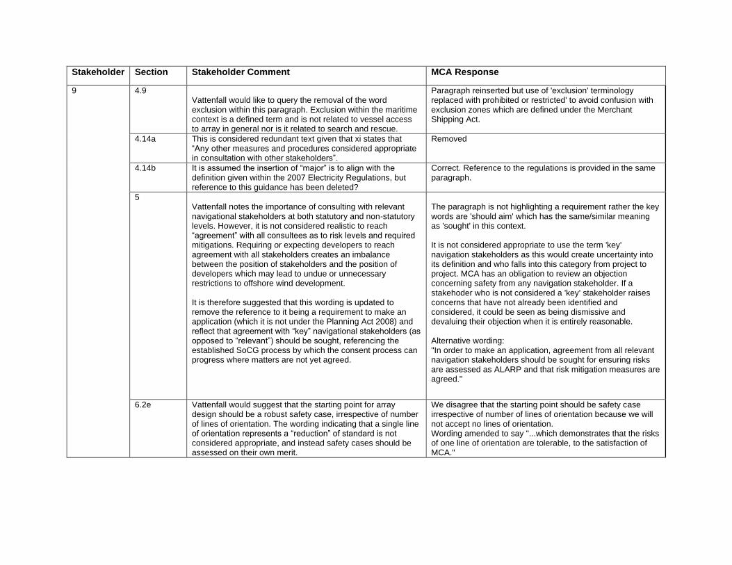
9 4.9 Vattenfall would like to query the removal of the word exclusion within this paragraph. Exclusion within the maritime context is a defined term and is not related to vessel access to array in general nor is it related to search and rescue.
Paragraph reinserted but use of 'exclusion' terminology replaced with prohibited or restricted' to avoid confusion with exclusion zones which are defined under the Merchant Shipping Act.
4.14a This is considered redundant text given that xi states that “Any other measures and procedures considered appropriate in consultation with other stakeholders”.
Removed
4.14b It is assumed the insertion of “major” is to align with the definition given within the 2007 Electricity Regulations, but reference to this guidance has been deleted?
Correct. Reference to the regulations is provided in the same paragraph.
5 Vattenfall notes the importance of consulting with relevant navigational stakeholders at both statutory and non-statutory levels. However, it is not considered realistic to reach “agreement” with all consultees as to risk levels and required mitigations. Requiring or expecting developers to reach agreement with all stakeholders creates an imbalance between the position of stakeholders and the position of developers which may lead to undue or unnecessary restrictions to offshore wind development. It is therefore suggested that this wording is updated to remove the reference to it being a requirement to make an application (which it is not under the Planning Act 2008) and reflect that agreement with “key” navigational stakeholders (as opposed to “relevant”) should be sought, referencing the established SoCG process by which the consent process can progress where matters are not yet agreed.
The paragraph is not highlighting a requirement rather the key words are 'should aim' which has the same/similar meaning as 'sought' in this context. It is not considered appropriate to use the term 'key' navigation stakeholders as this would create uncertainty into its definition and who falls into this category from project to project. MCA has an obligation to review an objection concerning safety from any navigation stakeholder. If a stakehoder who is not considered a 'key' stakeholder raises concerns that have not already been identified and considered, it could be seen as being dismissive and devaluing their objection when it is entirely reasonable. Alternative wording: "In order to make an application, agreement from all relevant navigation stakeholders should be sought for ensuring risks are assessed as ALARP and that risk mitigation measures are agreed."
6.2e Vattenfall would suggest that the starting point for array design should be a robust safety case, irrespective of number of lines of orientation. The wording indicating that a single line of orientation represents a “reduction” of standard is not considered appropriate, and instead safety cases should be assessed on their own merit.
We disagree that the starting point should be safety case irrespective of number of lines of orientation because we will not accept no lines of orientation. Wording amended to say "...which demonstrates that the risks of one line of orientation are tolerable, to the satisfaction of MCA."

Stakeholder Section Stakeholder Comment MCA Response
9 6.2f Vattenfall would suggest that a Safety Justification should demonstrate that risks associated with a Single Line of Orientation layout are tolerable and ALARP, as opposed to comparing against a layout with multiple lines of orientation.
The safety justification should highlight the change in risk, benefits and possibly cost of one line versus multiple. It needs to compare both scenarios for surface navigation, SAR and reasons for how SAR is still achievebale with less than two lines.
6.2g Vattenfall would note that, particularly in the case of developments located further offshore, micrositing requirements may not be apparent until it comes to physically installing the structures. It is understood that maintaining the agreed layout is important, however a degree of flexibility may be necessary, noting implications of halting construction. It should therefore be clarified whether the MCA are meaning case by case in terms of structure, or wind farm.
Amended to read: "g. Micrositing should be carried out in such a way which has the least impact on the overall layout within agreed distances in the marine licence. Any requirement to microsite installations beyond the agreed distance should be discussed with MCA on a case by case basis."
6.2h/i Vattenfall would observe that maintaining a consistent line of orientation through adjacent sites may not be conducive to a producing layout with multiple lines of orientation. Vattenfall would also note that it is assumed that a consistent line would only be required where there was not suitable space in between the adjacent sites for them to be considered distinct, however this is not clear within the text.
Sentence amended to say "Where multiple OREI sites have adjacent boundaries less than 1nm apart…"
6.2j Vattenfall would request clarity as to the role of the HMCG Policy & Standards Branch within the layout approval process? Are they distinct from the MCA and if so, is this an additional requirement moving forward with regards to gaining layout approval?
Amended to "HM Coastguard"
6.3a Should reference be made to the CAA (and MOD) given their remit with regards to aviation lighting?
The paragraph is in regard to marine navigation marking so it's not an appropriate place for aviation marking which is addressed in Annex 5.
6.4b Is this in reference to the location identifier prefix (e.g., “OSP-1”)?
Yes. Amended to "The ID marking of substations…"
6.4c This is considered ambiguous and dependent on conditions – can a minimum height be defined?
Readable from three metres above sea level is considered appropriate for mariners and provides developers with more flexibility on the height and size
9 6.6b In general this is welcomed and reflects a pragmatic approach to continual monitoring of risk mitigation, however this should agreed on a case by case basis in terms of the duration of monitoring, its scope and purpose.
These are normally defined within the consent conditions.

Stakeholder Section Stakeholder Comment MCA Response
6.6c Vattenfall would query the practicality of consulting with the stakeholder types listed. In practical terms requests or issues raised with respect to mitigation measures, e.g. AtN, should be fed through the relevant industry forums, to Trinity House or the MCA. If such feedback was received by the developer, the purpose of this feedback should be clarified that it is ‘in order to aid review of mitigation measures’.
The purpose is to obtain realistic information on any changes to traffic patterns therefore local knowledge from those operating in the area is needed. However, noting that there can be difficulties receiving responses from relevant stakeholder, the word 'obtained' has been amended to 'sought'.
6.9a Noting the removal of the “Whilst not mandatory” text referenced above, what is the legal position of Annex 5, as the text states “must fulfil”. Will this annex be issued for consultation prior to future updates?
It was considered redundant given the nature of the MGN and use of 'may' throughout the paragraph. Annex 5 has been through consultations to reach its current version and future updates may go through consultation if necessary. Whilst the MGN is guidance, there are some requirements in Annex 5 for Search and Rescue procedures and response which are incorporated into post-consent documentation.
6.9e Vattenfall acknowledges requirements will evolve as the industry advances, but as per previous point how will these changes be implemented, and who will be consulted? It is also noted that advancements in the industry in relation can provide benefit to search and rescue operations (e.g., larger turbines leading to wider minimum spacing).
Consultation will take place through NOREL and appropriate SAR stakeholders.
Annex 1 2nd para
The relationship between MGN 543, the NRA methodology and the MGN 543 checklist could be made clearer.
This is clarified in Sections 4.1 and 4.4
Annex 2 The Shipping Template as it stands does not provide clear guidance as to what is expected. It is recommended that additional existing guidance is considered.
The template is guidance on distances and associated risk. It is not intended to be prescriptive.
10
Track Changes
Comments and amendments in the MGN document using Track Changes
Noted and changes amended
3.3 How does this co-relate with new paragraph under 2.2 which makes reference to strategic, large & commercial?
We see this as being consistent with the sentence in 2.2 which states that the MSA and SOLAS applies to all vessels on all voyages.
10 4.2 Furthermore, suggest include reference to the potential requirement for smaller domestic vessels & coasters to navigate with larger vessels on DWRs etc.
Amended to: "Assessments should be made of the consequences of ships deviating from normal routes to avoid proposed sites, including smaller vessels e.g domestic, coasters, recreational and fishing vessels, entering shipping routes with larger vessels"

Stakeholder Section Stakeholder Comment MCA Response
4.6.f It would also be positive for it to take into account the cumulative impact of other renewable developments in the locality.
Sentence amended to include "…and nearby structures and installations."
4.6.f If referencing that it is common for deviations from track of more than 20 degrees, why is 20 degrees stated? What is the logic? This is no doubt from a study or similar but Chamber would appreciated MCA referencing such or letting us know where from if not going to reference within the document. Would 30 degrees be correct? “Deviations from track by more than 20 degrees are common…. “Deviations from track by as much as 20 degrees are common, but can be more….
We believe this was a Trinity House paper proposed during the previous MGN update. Paragraph 4.6.g.iii (1) does state: "Deviations from track by as much as 20° or more, are common and must be considered in developing corridors through OREIs."
4.6.f would like to see guidance added if possible on navigation channels within developments. Even if a sentence or two stating should be dealt with on case by case basis and follow the same principles as inter development corridors?
The section that addresses corridors, 4.6, does mention in para 4.6.g that it applies to corridors through an array (in addition to between two arrays, and between an array and shore.
4.7.c.i Chamber notes that you may not see the deepest draught vessels over a 28 day period and that it may be necessary to observer for a longer time.
Noted. In this instance we would expect comments to be provided to the developer at the Scoping stage.
6.5 Does this include a mid-water or seabed device which floats to the surface upon failure of mooring and so creating a navigational hazard? If not, Chamber would appreciate some guidance on such.
Yes, the sentence includes "those suspended in the water column"
10 Annex 2 Shipping template
Suggest reference included to: (1) The Netherlands made an assessment of sea room requirements using data supported by the PIANC assessment for channel design and the PIANC Interaction Between Offshore Wind Farms and Maritime Navigation (2018) report. In general, they strive for an obstacle free, or buffer, zone of 2nm between wind farms and shipping routes.
Added as a footnote

Stakeholder Section Stakeholder Comment MCA Response
11 4.9 Query the rationale for removal of 4.9b Reinserted.
12 Track changes
Comments and amendments in the MGN document using Track Changes
Noted and changes amended
6.3 Final sentence
Does this statement water down the requirements laid out in Annex 5 and unnecessary duplication of section 6.4C
We don't think so as it includes working lights, not just those on ID boards
13 6.2b Suggest 'minimised' is replaced with 'ALARP': "...risks to vessels and/or SAR helicopters are ALARP…"
Amended to "as low as reasonably practicable"
6.2d Suggest replace "...must be aligned and in straight rows or columns." with "...must, as a minimum, accommodate a single consistent line of orientation. The acceptability of periphery turbines, with smaller spacings than in the internal array, will be evaluated on a case-by-case basis."
Entire section amended to incorporate these suggestions
6.2e Suppest replace paragraph with "In compliance with safety of navigation and search and rescue requirements in the UK, developers of every offshore renewable energy project with floating and/or surface piercing devices should undertake a thorough appraisal of the safety benefits afforded by two consistent lines of orientation and, based on this, either implement such layouts or, where appropriate, consider alternatives. The MCA will not consider any layout proposals with just one line of orientation, without supporting documentation which fully justifies the proposed layout to the satisfaction of MCA."
6.2h Suggest replace "...whilst still maintaining plans for at least two lines of orientation.” with "...whilst still maintaining due regard to the benefits afforded by two lines of orientation"
14 Summary There are different sets of EIA guidance applicable depending on distance offshore and regulating authority. This is an oversimplification and should be amended to clarify to ensure that all reviewers are clear what the guidance applies to.
MCA guidance applies to all UK waters. Reference to EIA removed.
14
Summary Are these bespoke documents also up for consultation and what is the legal application behind those documents? Also why are the SAR checklist and the ERCOP not included as official annexes. Again, does this mean they are to be applied in a different way?
These documents are/have been consulted on seperately e.g. through NOREL. The SAR checklist and ERCoP are addressed in Annex 5.

Stakeholder Section Stakeholder Comment MCA Response
2.2 Section 2.1 and 2.2 discusses definitions used within MGN 543 with regards to sea lanes. The updates within Section 2.2 have expanded the MCA’s position on what constitutes a sea lane but rather than it being tied to a legal position have instead taken a broader approach to the definition. Whilst SSER agree that important routes do exist outside of IMO routeing measures, given the title of this section, SSER do not agree that this an appropriate place to include this expanded definition. If this definition (of a sea lane) is subsequently included within another section of the MGN, it is our opinion that before this wider view can be used, a method for the calculation or definition of a sea lane must be included within the methodology or the updated MGN to allow developers to adequately assess the importance of identified sea lanes rather than leaving it to a case-by-case/site-by-site judgment.
It is difficult to define or quantify sea lanes or shipping routes in terms of number of transits as there may be other factors that differentiate the significance of a route e.g. less frequent but vital ferry or supply routes. UNCLOS provides a framework to refer to for other treaty conventions. SOLAS Convention Chapter V references sea lanes and also states that the articles apply to all vessels on all voyages. This is enshrined into UK law through the Merchant Shipping Act 1995, as amended. MCA is content with the wording to remain in this paragraph as it explains what MCA consider to be sea lanes in the OREI context.
2.2 UNCLOS uses recognized sea lanes as a defined term and therefore definition of this should be included within the MGN. It is SSER’s opinion that this differs from the use of the term ‘sea lanes’ and the two should not be conflated.
UNCLOS references internationally important sea lanes which is already included in the document under 2.1.
2.1 This sentence should clarify that UNCLOS is referenced in EN-3 not that the position is re-iterated. Also, again it is important to make clear that there is a difference between a recognized sea lane under UNCLOS and a sea lane under MGN 543
The position that consent should not be granted if the development interferes with the use of recognised sealanes is stated in EN-3 s.2.6.161. Sentence amended to say "... the position is repeated…"

Stakeholder Section Stakeholder Comment MCA Response
14 2.4 Whilst SSER recognise that shipping is an essential and valuable economic activity within the UK it would be appropriate to also include a reference to the importance of renewable energy and include a reference to the relevant policy sections of relevant policy documents i.e. the UK’s draft National Energy and Climate Plan (NECP). SSER believes that there needs to be an assessment of the impact of all maritime industries with prioritisation for those industries contributing most to meeting the net zero objective, such as offshore wind. With UK Government commitment to deploy 40GW by 2030 (up from 30GW as outlined in the Offshore Wind Sector Deal) and advice from the Committee on Climate Change to reach 75GW by 2050 to achieve net zero, it will be critical for the Marine Plans to support the pipeline of offshore wind and indeed floating offshore wind, now and throughout the coming years.
This is a guidance note on the safety of navigation and its focus is on the impotance of navigational practices, safety and emergency response in and around OREIs. Reference to the importance of renewable energy to the UK is addressed through other government departments. The assessment of the impact of all maritime industries is not for a MCA Marine Guidance Note.
2.5 Relevance of this paragraph under ‘Primary and Secondary Legislation with regard to OREIs and Navigation’. Suggest this section is relocated to the introduction section.
The paragraph provides context on where the MCA sits in the consenting and licensing process.
2.5 How the MCA relates to other statutory and non-statutory authorities would be a useful clarification to add the MGN, i.e., the hierarchy of decision making.
To determine a hierachy of decision making priority is not appropriate.
General Reference to the IMO FSA.
Should reference in this section be made to the IMO FSA process given that it is referenced heavily within the methodology document?
Reference to IMO FSA added to 4.1.
3.1 Explanation required as to the removal of ‘whilst not mandatory’ – has the legal position of MGN 543 changed?
It was considered redundant given the nature of the MGN and use of 'may' throughout the paragraph. The MGN is guidance as stated in this paragraph as well as the Summary
3.1 Confirm terminology – MSLOT for example use EIA not ES. Use of 'Environmental Statement' replaced with 'EIA Report'
4.3 Request that the consideration of the use of the OREI as a place of refuge is removed given the size and complexity of modern OREIs, as well as the potential security concerns that have been raised (this should also relate to MGN 372). This is not to suggest access is restricted but instead not actively encouraged, particularly given the concerns relating to security and unlawful access.
MCA considers it appropriate to include reference to emergency refuge as it is consistent with SOLAS, however this will be assessed on a case-by-case basis.

Stakeholder Section Stakeholder Comment MCA Response
14 4.5a SSER asks that the position on AIS is considered, given that it is realistic within the time frame of the new MGN period of validity that changes may be made to AIS (carriage) that mean it becomes more comprehensive and as development areas move further offshore the makeup of traffic changes.
MCA recommends that data requirements for traffic surveys are agreed prior to the surveys being undertaken. The survey requirements in the 4.5 have been agreed with navigation stakeholders through NOREL.
4.6f Given this MGN is applicable to the entire REZ, consideration should be given to the use of the word ‘must’ provide a corridor without knowing the specifics of any individual development and the legal context. Given that internal spacing is increasing and wind farm developments are moving further offshore there is a case that a corridor may not be considered essential in a particular circumstance, yet ‘must’ may mean that one is included where there is no navigational safety benefit.
Amended. The word "must" removed.
4.6 For consideration - reference to other nationalities guidance can be confusing and often does not relate to the shipping template, corridor calculation guidance or MGN 372. Secondly there should also be a clearer distinction between corridor widths (within a development) and shipping routes (external to a development). This also relates back to Section 2 comments.
Other guidance is provided for context. It is already clear that corridors widths refer to within a development and it's unclear what further clarification is required.
Example corridor calculation figure
(note headings/numbering is hard to follow at this point) Could be better designed/clearer as to the guidance it is offering; also relates to point above and the varying methods of guidance/methods included and the terminology used.
It is unclear what clarification is required.
4.9 Para starting "where it is not feasible…"
Previously this was in the context of exclusion but now used to reference layouts. Under what context would it not be feasible for a vessel to navigate through a windfarm?
Original bullet point b reinserted.
4.13 Links to the methodology should be clearer/better defined to help the reader understand the purpose of the two documents. Reference to IMO FSA Process and HSE R2P2 could be made here in relation to ALARP, rather than (or in addition to) later on in the WIND FARM SHIPPING ROUTE TEMPLATE table.
Links to the Methodology document is provided in Section 4.1. Reference to ALARP definition added
4.14.a.iii Question removal of safety zone supporting documentation? Is it no longer applicable and/or what is now applicable?
Reference to the safety zone regs is provided in Section 4.14b

Stakeholder Section Stakeholder Comment MCA Response
14
4.14a in general
Should be updated to reflect industry best practice. Whilst recognising that some risk controls are the same for most or all projects, the list of agreed controls will differ from project to project. Furthermore, the guidance relates to wind, wave and tide installations so best practice with differ
4.14.a.iv What are the parameters for the area being considered an ATBA?
This is an IMO routeing measure and further information can be found through their guidance.
Note: This list is not exhaustive.
Is this not covered by xi? Any other measures and procedures considered appropriate in consultation with other stakeholders.
Removed
5 Is there any defined method for who constitutes a relevant navigation stakeholder – perhaps include a link to methodology? Useful to define ALARP in this document (as well as referencing HSE / IMO guidance). This section in general seems to refer the user to this MGN and the methodology being applicable to DCO applications only – some clarity needed here and perhaps this section better near the front end of the MGN.
Examples of navigation stakholders is provided in the Methodology document (Annex E2) Reference to ALARP added under Section 4.13 Reference is made to the consent process which is a term applicable in all four countries of the UK, not just in England and Wales where the DCO process is used.
6 Should this sit under NRA risk mitigation? Given that layout design is 6.2 is this section intended to cover post consent elements. If so needs more thought as the post consent phase is much wider than just layouts. Also confirmation that it is still possible to agree a final layout as part of your NRA; this may be the case for smaller developments or novel developments?
The NRA is compiled in the pre-consent stages whereas Section 6 refers to the post-consent stages. Sections 6.3 to 6.9 address other post-consent considerations e.g. marking, hydrography etc. The section is intended to help developers with their post-consent documentation.

Stakeholder Section Stakeholder Comment MCA Response
14 6.2 SSER and the industry via Renewable UK have engaged with the MCA on Layout issues including at the 9th NOREL Technical Working Group No consideration of the size of current developments and that consistent bearings may not be possible (Mercator). No consideration of increased internal spacing now being consented and constructed. This section should cross reference to the information included within the methodology as to risk assessment. SAR and surface navigation should be considered separately on a case by case basis. Different sites have different issues and a frequency / consequence of the issues should be considered. The layout process must be related to both the methodology and a risk assessment process. See comment on safety justification.
SAR should not be considered separately - collectively make up the same and is considered together as part of MCA's assessment. Consideration of internal spacing is addressed. Section 6.2 reworded to incorporate other comments from stakeholders.
6.2g Clarify if this is intended to be on an overall project basis and not that every incidence of micrositing will require discussion with the MCA. i.e. if all micrositing was within a tolerable agreed distance e.g. 50m. Maintaining flexibility in micrositing is essential to ensuring buildability given increased water depth and likely greater sensitivity to local ground conditions
Paragraph reworded to include reference to agreed distances in the marine licence
6.2f Expectations of the safety justification should be included, potentially within the methodology. If a single line of orientation is assessed within the navigational risk assessment why is this not sufficient supporting assessment to proceed with that layout (including a single line of orientation). There seems to be some confusion overlap here with the purpose of a safety justification and the purpose of the NRA as part of the overarching EIA process. Is there overlap with section 6.2 here?
The Methodology document doesn't mention assessing the NRA with a single line of orientation. Layouts are agreed post-consent so it isn't appropriate to include reference to a safety justification. The NRA does not assess all the elements we would consider to be required for a justification of one line of orientation.
6.2i Relevance to MGN – future case projects should be dealt with as and when they arise?
This issue is relevant to safe navigation and emergency response. Agreed that future projects are dealt with as they arise.
6.2h Suggested inclusion to enable case by case consideration - Where multiple OREI sites have adjacent boundaries, including extensions to existing sites, due consideration must be given to the requirement for lines of orientation which allow a continuous passage for vessels (where frequency of occurrence demonstrates a need) and/or SAR helicopters
Section 6.2 reworded to incorporate additional comments

Stakeholder Section Stakeholder Comment MCA Response
through both sites, whilst still maintaining plans for at least two lines of orientation.
14 6.2j What is the ‘HMCG Policy & Standards Branch’. SSE believe the inclusion of this is in direct conflict with the DCO/DML conditions where approval is only required from the MMO in consultation with the MCA. This appears now to be a double approval process? The also raises question about the consideration of SAR and vessel impacts and whether they should be considered in the same way across all projects or on a case by case basis.
Layout approval has always been made by both mentioned branches of the MCA i.e. Technical Services Navigation and HMCG. HMCG Policy and Standards Branch is the relevant part of HM Coastguard, however, amended to 'HM Coastguard'.
6.3a Should reference be included to the CAA and MoD? This section is for Marine Navigational Marking. Aviation lighting and marking is addressed in the SAR guidance in Annex 5
6.3f Should this be included at all given it is not within MCA’s remit, or if it is included should it be raised sooner within the MGN.
The sentence reads: "It should be determined if the site should be fitted with audible hazard warning in accordance with IALA recommendations". This is a possible risk control measure for minimising navigational risk and is appropriate to include it here.
6.4b Not clear what is expected here and how this relates to Trinity House’s remit?
Sentence amended to say it is the ID marking.
6.6.c This is onerous and above the requirements of the DCO/DML. Traffic monitoring is requested as a condition in the DML. This section clarifies from where information should be obtained.
6.9a What is the legal stance of this Annex, given the MGN is not mandatory? At what point will this Annex be reviewed and who will get to comment on it? This also relates back to the inclusion of the ERCOP and SAR checklist as annexes. SSER believe an approval process for this annex should also be included.
Annex 5 has been through consultations to reach its current version. Whilst the MGN is guidance, there are some requirements in Annex 5 for Search and Rescue procedures and response which are incorporated into post-consent documentation.
Annex 1 It should be clear within the document where the methodology should be used. The MGN checklist is not currently workable for the Methodology application and this should be reconsidered. Perhaps instead relating the methodology to the application of the MGN 543, then just including the elements of the MGN within the checklist.
This is mentioned in section 4.1. The MGN Checklist follows the MGN elements.
Annex 2 Various sets of guidance that consider route width, corridor widths etc should be reviewed and clarified.
Agreement of distance are dealt with on a case by case basis using data gathered

Stakeholder Section Stakeholder Comment MCA Response
14 Wind Farm Shipping Route Template
Does not show as a track change – therefore some reviewers may have missed that this table is new in its entirety. It is also not clear why increased prescriptiveness has been included in the shipping template after being removed from MGN 543 following review (in line with actual experience). First mention of FSA guidance making it seem this is the only place it is applicable. We believe this importance guidance should be given more prominence, and at least referenced, in the main text when discussing risk assessment. Health and Safety Executive (2001) ‘Reducing Risks, Protecting People’ – needs updating to 2019 version.
The table is guidance and not meant to be prescriptive, hence reference to it not being a prescriptive tool. Experience of the simplified version in MGN543 showed that it was being used too literally by some developers e.g. some OREIs were automatically sited 0.5nm away without indication of level of risk. It was felt the inclusion of the additional information on the effects to vessels would be useful guidance. Reference to FSA added in earlier sections. The 2019 version could not be found.
Annex 3 Has been updated to include ‘and wave’ but was this included within the original NOREL paper? If not this section should remove its reference to being a NOREL paper in its entirety. The worst-case approach presented in calculating minimum clearance depth, using the deepest draft vessel, taking its dynamic draft and then adding a further 30%, would be very difficult to achieve in real life. Also where it states “Establish from traffic survey the deepest draft of observed traffic”, normally the survey includes a 10 mile buffer so the deepest draft vessel may be at minimal risk of interacting with the subsea device due to their passing distance. Helpful if this could be qualified, by stating the deepest draft vessel expected to over sail the device. In practice, the MCA have shown a willingness to be flexible and accept probabilistic assessments of the under keel risk. Reference to this alternative method could be added.
Use of 'and wave' removed and footnote added to say it can also be applied to wave devices.
15 6.2 The process would benefit from greater clarity and increased transparency in the assessment criteria. innogy consider that the wording in Section 6.2, should consider the following:
N/A
That two lines of orientation should not be assumed as a default layout design in all cases. In the future, larger turbines and new technology will be proposed and it should be made clear that the authorities remain open to consider different layout design solutions.
Each layout proposal will be assessed and agreed on a case by case basis.

Stakeholder Section Stakeholder Comment MCA Response
15 That extension projects pose a unique design challenge and for these projects specifically it may be necessary to propose a design which does not include two consistent lines of orientation within the combined array. It should be clear that there is an opportunity to work together to develop an acceptable design and explore alternative mitigations.
Each layout proposal will be assessed and agreed on a case by case basis.
That a safety justification should be proportional to the complexity and circumstances of the designs being proposed.
MCA may receive requests for definitions into proportionality, complexity and circumstances.
That a cost benefit analysis is referenced in the MGN as a component of the assessment of a layout.
CBA is an available tool and it is for developers to decide whether or not to use it. CBA is part of FSA and included in the Methodology document.
That there is a requirement for the MCA to state why a design is not acceptable so that developers can seek to address those concerns.
MCA provides feedback to developers on layout proposals and will discuss this necessary. 6.2.g states each will be assessed and agreed on a case by case basis.
2.2 innogy appreciates the desire to broaden out the definition of essential areas, however the wording leaves some doubt as to what is considered essential. The term "other sea routes transited by all vessel types" seems very broad. We recommend this is reworded to make clear how strategic routes will be defined. Will this be at the discretion of MCA, secretary of state or IMO?
UNCLOS provides reference to "essential to international navigation" which is then referenced in the SOLAS Convention and that the SOLAS articles apply to all vessels on all voyages. This is enshrined into UK law through the Merchant Shipping Act 1995, as amended. Stakeholder consultation will determine how essential shipping routes are as it will be location dependant.
2.4 Directly quoting the Marine Policy Statement in the MGN is not helpful, as it could become out of date if the Marine Plan is updated and does not include the whole context of the plan. It would be better to say that authorities will have regard to the current Marine Plan, without specific reference to individual phrases.
The quote provides context into the importance of shipping to the UK and provides assurance that it will be considered by marine planners.
4.3 It would be helpful to further clarify "damage to the marine environment", if it is intended to limit the definition to pollution control and salvage.
It could be any damage, not just pollution and salvage.
4.11a.i The MGN and the associated Annex 4 should be updated to make clear that the 500m buffer only applies to the array area and not to cable routes.
500m buffer has been removed following a review of the hydrography requirements
6.2e This should clarify that this restriction is in relation to fixed infrastructure and that any associated floating equipment, such as Flidars, do not need to sit on the grid.
It also applies to floating infrastructure. Single deveices associated with the array will be assessed seperately
6.4c The current wording is open to interpretation. Would the MCA be willing to commit to a minimum lettering height e.g. 1m as per the IALA recommendation.
The current wording provides flexibility without being too prescriptive.

Stakeholder Section Stakeholder Comment MCA Response
15 6.7 "a. It should be determined at what depth below the seafloor export cables are buried to ensure there are no changes to charted depths... " This wording is very open ended and innogy would welcome clarification on the MCA’s expectation of the developer in order to meet this in terms of survey specification and timescales.
MCA does not set target burial depths. The expectation is that cables are buried and where this is not possible due to seabed conditions, the cable is protected to ensure navigation is not compromised by changes in depths.
6.7 Is it appropriate to include an underkeel clearance requirement for wave devices?
Yes, for bottom mounted devices and any suspended in the water column.
6.2g Recognition needs to be given to the possibility of conflicting mitigations (e.g. avoidance of AEZs or sensitive habitats as part of other management plans).
Each layout proposal will be assessed and agreed on a case by case basis so any conflicting mitigations would be included by the developer in their proposal.
6.2h This should mention the potential for alternatives to be agreed with MCA (e.g. agreement on a corridor between projects and extensions to mitigate non-alignment)
6.2j states that layouts will be agreed on a case by case basis.
6.2i This point is noted but seems incongruous as many factors from existing nearby projects will influence SAR and layout for a given project, not just periphery spacing.
Noted. The section specifically addresses periphery turbines and MCA recognises cumulative impacts could influence navigation and SAR in the area (Section 4.5d)
6.6 Is the MCAs intention to request a specific vessel monitoring plan as part of the DCO/ML? Or will this be secured through existing requirements/conditions for adherence to the MGN?
Traffic monitoring will be requested as a condition in the marine licence.
16 6.2 RWE Renewables UK Limited consider that the wording in Section 6.2, should consider the following:
N/A
That two lines of orientation should not be assumed as a default layout design in all cases. In the future, larger turbines and new technology will be proposed and it should be made clear that the authorities remain open to consider different layout design solutions.
Each layout proposal will be assessed and agreed on a case by case basis.
That extension projects pose a unique design challenge and for these projects specifically it may be necessary to propose a design which does not include two consistent lines of orientation within the combined array. It should be clear that there is an opportunity to work together to develop an acceptable design and explore alternative mitigations.
Each layout proposal will be assessed and agreed on a case by case basis.
That a safety justification should be proportional to the complexity and circumstances of the designs being proposed.
MCA may receive requests for definitions into proportionality, complexity and circumstances.
That a cost benefit analysis is referenced in the MGN as a component of the assessment of a layout.
CBA is an available tool and it is for developers to decide whether or not to use it. CBA is part of FSA and included in the Methodology document.

Stakeholder Section Stakeholder Comment MCA Response
16 That there is a requirement for the MCA to state why a design is not acceptable so that developers can seek to address those concerns.
MCA provides feedback to developers on layout proposals and will discuss this necessary. 6.2.g states each will be assessed and agreed on a case by case basis.
2.2 RWE Renewables UK Limited appreciates the desire to broaden out the definition of essential areas, however the wording leaves some doubt as to what is considered essential. The term "other sea routes transited by all vessel types" seems very broad. We recommend this is reworded to make clear how strategic routes will be defined. Will this be at the discretion of MCA, Secretary of State or IMO?
UNCLOS provides reference to "essential to international navigation" which is then referenced in the SOLAS Convention and that the SOLAS articles apply to all vessels on all voyages. This is enshrined into UK law through the Merchant Shipping Act 1995, as amended. Stakeholder consultation will determine how essential shipping routes are as it will be location dependant.
2.4 Directly quoting the Marine Policy Statement in the MGN is not helpful, as it could become out of date if the Marine Plan is updated and does not include the whole context of the plan. It would be better to say that authorities will have regard to the current Marine Plan, without specific reference to individual phrases.
The quote provides context into the importance of shipping to the UK and provides assurance that it will be considered by marine planners.
4.3 It would be helpful to further clarify "damage to the marine environment", if it is intended to limit the definition to pollution control and salvage.
It could be any damage, not just pollution and salvage.
4.11a.i The MGN and the associated Annex 4 should be updated to make clear that the 500m buffer only applies to the array area and not to cable routes.
500m buffer has been removed following a review of the hydrography requirements
6.2e This should clarify that this restriction is in relation to fixed infrastructure and that any associated floating equipment, such as Flidars, do not need to sit on the grid.
It also applies to floating infrastructure. Single deveices associated with the array will be assessed seperately
6.4c The current wording is open to interpretation. Would the MCA be willing to commit to a minimum lettering height e.g. 1m as per the IALA recommendation.
The current wording provides flexibility without being too prescriptive.
6.7 "a. It should be determined at what depth below the seafloor export cables are buried to ensure there are no changes to charted depths... " This wording is very open ended and innogy would welcome clarification on the MCA’s expectation of the developer in order to meet this in terms of survey specification and timescales.
MCA does not set target burial depths. The expectation is that cables are buried and where this is not possible due to seabed conditions, the cable is protected to ensure navigation is not compromised by changes in depths.
6.7 Is it appropriate to include an underkeel clearance requirement for wave devices?
Yes, for bottom mounted devices and any suspended in the water column.
6.2g Recognition needs to be given to the possibility of conflicting mitigations (e.g. avoidance of AEZs or sensitive habitats as part of other management plans).
Each layout proposal will be assessed and agreed on a case by case basis so any conflicting mitigations would be included by the developer in their proposal.

Stakeholder Section Stakeholder Comment MCA Response
16 6.2h This should mention the potential for alternatives to be agreed with MCA (e.g. agreement on a corridor between projects and extensions to mitigate non-alignment)
6.2j states that layouts will be agreed on a case by case basis.
6.2i This point is noted but seems incongruous as many factors from existing nearby projects will influence SAR and layout for a given project, not just periphery spacing.
Noted. The section specifically addresses periphery turbines and MCA recognises cumulative impacts could influence navigation and SAR in the area (Section 4.5d)
6.6 Is the MCAs intention to request a specific vessel monitoring plan as part of the DCO/ML? Or will this be secured through existing requirements/conditions for adherence to the MGN?
Traffic monitoring will be requested as a condition in the marine licence.
17 4.5a Suggest amendment to read: "AIS data alone will not constitute an appropriate traffic survey; radar and manual observations, for example, will ensure…"
Radar and manual observations are required to supplement AIS which does not capture smaller vessels and is not as reliable.
4.10b Suggest reintroducing 'preliminary' so sentence reads: "A preliminary assessment on the potential impacts to SAR…"
Reinserted.
6.2b Suggest amending final sentence to read: "…show that risks to vessels and/or SAR helicopters are ALARP and include proposed mitigation measures"
Amended
6.2e Suggest amending first sentence to read: "…surface piercing devices, where the site-specific data and risks demonstrate a need, in order to satisfy…"
This would change the meaning of the sentence to say that developers should only plan for two lines when the risks demonstrate there is a need, therefore the default position is to aim for one.
6.2e Suggest amending second sentence to read: "…which fully justifies the proposed layout to the satisfaction of MCA".
Section 6.2 revised to incorporate additional comments
6.2f Suggest amendment to first sentence to read: "Where one line of orientation…" [delete 'just']
The sentence emphasis a single line of orientation is not preferable.
6.2f Suggest deleting final sentence saying no lines of orientation will be acceptable.
MCA must provide a SAR service in the UK SAR Region which include use of all SAR assets. MCA considers the inclusion of the sentence is a necessity.
6.2h Suggest amending end of sentence to read: "…whilst still maintaining plans for lines of orientation as appropriate to the site specific nature of that site".
Section 6.2 revised to incorporate additional comments
6.2i Suggest deleting the final sentence that says the definition of 'adjacent' will be assessed on a case by case basis. Reason: It would be helpful to include methodology for how “adjacent” will determined on a case by case basis in future.
Moved to 6.2.h
17 Annex 1 Template
In '>5nm' row, suggest deleting "Adjacent wind farm introduces cumulative effect" and "minimum distance from TSS entry/exit"
Experience of the simplified version in MGN543 showed that it was being used too literally by some developers e.g. some OREIs were automatically sited 0.5nm away without indication

Stakeholder Section Stakeholder Comment MCA Response
of level of risk. It was felt the inclusion of the additional information on the effects to vessels would be useful guidance. The template does not require a minimum 5nm from a TSS entry/exit - it suggests the tolerability is acceptable. The template is not a precriptive tool and should be used as guidance.
General In summary, it is encouraging to see that the case-by-case approach to the assessment of OREIs is maintained as it relates to navigational safety and search and rescue, noting that sites vary in the appropriateness of the number of lines of orientation of rows and, for example, setback distances from shipping routes. On this basis, it would seem inappropriate to completely dismiss cases where no lines of orientation are included in a wind farm layout, if the case-by-case situation suggests impacts can be reduced to ALARP. Appreciating locations of OREIs that may support this conclusion are more likely to be developed later in the future, for example as offshore wind leases are offered in locations further from maritime traffic and traditional search and rescue capabilities, it is requested that as a minimum the inclusion of this in the MGN Guidance is evaluated at suitable intervals.
A wind farm with zero lines of orientation compromises MCA's obligations to provide a SAR service in the UK SAR region. The MGN will be reviewed and updated as required, in line with advances of industry developments.
General In addition to the revisions made to MGN 543 and MGN 372, Equinor would encourage the MCA to clarify the methodology and thresholds used in determining certain parameters in the next revision, for example the definition of an “adjacent” wind farm and in what cases one line of orientation may be “acceptable”. Further clarity on these methodologies will ensure Equinor can make the most appropriate layout decisions at the earliest opportunity.
The MGN will be reviewed and updated as required, in line with advances of industry developments. Each project will be risk assessed on a case by case basis.
18 2.2 NPS EN-3, and article 60(7) of UNCLOS (1982), refer to ‘recognised sea lanes essential to international navigation’. Any perceived discrepancy between the use of the term ‘sea lanes’ in NPS EN-3, and a potentially broader definition of ‘sea lanes’ presented in MGN 543, may introduce uncertainty.
The strategic importance of sea lanes and how essential they are to navigation will be location specific and will be determined following the traffic study and stakeholder consultation.

Stakeholder Section Stakeholder Comment MCA Response
2.4 The MCA may wish to consider incorporating some of the following text as part of Section 2.4. “In June 2019, the UK became the first major economy in the world to pass laws to end its contribution to global warming by 2050. The target will require the UK to bring all greenhouse gas emissions to net zero demonstrating that clean growth has been placed at the heart of the UK’s Industrial Strategy. As highlighted in the UK Government’s recent consultation for the next Contract for Difference allocation round, offshore wind is being viewed as strategically important to meeting net zero emissions by 2050. Furthermore, the Government’s Manifesto increases the deployment ambition of the Sector Deal, and has set a target to deliver 40GW by 2030.“
While it is perhaps not noted in the MGN, we are always clear on our support of Government targets in regards to renewables. However, it can’t be at the detriment of established shipping routes – particularly if these are changed because of cumulative impact. The subject of balancing different interests lies within marine spatial planning policies which lies outside the scope of this MGN.
6.2b Suggest 'minimised' is replaced with 'ALARP': "...risks to vessels and/or SAR helicopters are ALARP…" Note - the suggested edit above is copied from the R-UK response.
Amended to "as low as reasonably practicable"
6.2d Suggest amendment: “In order to minimise risks to surface vessels and/or SAR helicopters transiting through an OREI, structures (turbines, substations etc) must, as a minimum, accommodate a single consistent line of orientation where no compelling evidence of additional SAR provisions to improve safety standards is included in the design. The acceptability of periphery turbines, with smaller spacings than in the internal array, will be evaluated on a case-by-case basis.” The intention of the proposed edit is to ensure that readers (including decision-makers) interpret Section 6.2(d) consistently with: • Sections 6.2(e) and 6.2(f) - which introduce the possibility that one line of orientation may be acceptable (subject to supporting justification); and with • Section 6.2(i) - which introduces the possibility of periphery turbines with smaller spacings (subject to case-by-case determination). Taken alone, the current wording of Section 6.2(d) may leave readers with the impression that dense borders will not, under any circumstances, be acceptable to the MCA. In addition, the proposed wording, while supporting one-line of orientation, also invites developers to consider improving SAR capability by including new technology into the windfarm that may be able to support a range of marine distress events in
This places the emphasis on one line, not two and leaves it open for less than one being acceptable. Readers, and decision makers, should be considering the whole of 6.2 with regards to layout and not individual sections on their own. MCA welcomes new technology and will discuss this with developers, but not at the expense of national SAR requirements. Section 6.2 revised to incorporate additional comments.
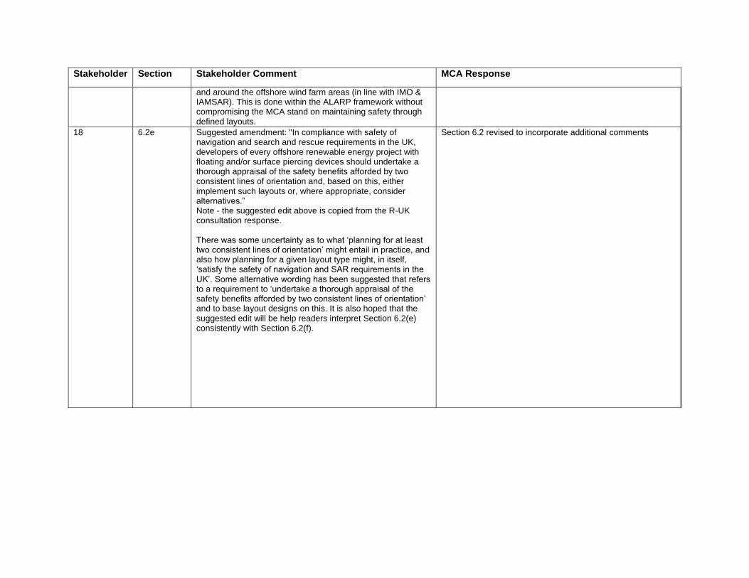
Stakeholder Section Stakeholder Comment MCA Response
and around the offshore wind farm areas (in line with IMO & IAMSAR). This is done within the ALARP framework without compromising the MCA stand on maintaining safety through defined layouts.
18 6.2e Suggested amendment: "In compliance with safety of navigation and search and rescue requirements in the UK, developers of every offshore renewable energy project with floating and/or surface piercing devices should undertake a thorough appraisal of the safety benefits afforded by two consistent lines of orientation and, based on this, either implement such layouts or, where appropriate, consider alternatives.” Note - the suggested edit above is copied from the R-UK consultation response. There was some uncertainty as to what ‘planning for at least two consistent lines of orientation’ might entail in practice, and also how planning for a given layout type might, in itself, ‘satisfy the safety of navigation and SAR requirements in the UK’. Some alternative wording has been suggested that refers to a requirement to ‘undertake a thorough appraisal of the safety benefits afforded by two consistent lines of orientation’ and to base layout designs on this. It is also hoped that the suggested edit will be help readers interpret Section 6.2(e) consistently with Section 6.2(f).
Section 6.2 revised to incorporate additional comments

Stakeholder Section Stakeholder Comment MCA Response
18 6.2e Suggested amendment: "The MCA will not consider any layout proposals with just one line of orientation, without supporting documentation which fully justifies the proposed layout to the satisfaction of MCA." Note - the suggested edit above is copied from the R-UK consultation response." There was some debate around whether (a) there’s a typo in this sentence, i.e. whether it’s meant to read ‘to this standard’ rather than ‘of this standard’, or (b) the current drafting is intentional, i.e. that the standard that’s referred to is two lines of orientation. In view of the fact that offshore wind farm layout ‘standards’ have not yet been established or defined, a simple reference to ‘the proposed layout’ is suggested as alternative wording.
Section 6.2 revised to incorporate additional comments
6.2f In no circumstances, will a layout with no lines of orientation be acceptable to the MCA.” Addressed in main body of letter
As explained on several occasions, MCA has statutory obligations to provide a SAR service in the UK SAR Region which includes having the full resource of all SAR assets available. Zero lines of orientation means SAR helicopters are unable to transit through wind farms which is unacceptable to MCA.
6.2h Suggest replace "...whilst still maintaining plans for at least two lines of orientation.” with "...whilst still maintaining due regard to the benefits afforded by two lines of orientation"
Section 6.2 revised to incorporate additional comments
6.2j It would be helpful if the wording of Section 6.2(j) could clarify whether the decision-maker will, in the future, be consulting with, and determining the formal acceptance of, two separate Branches within the MCA. If so, it would be helpful to understand the varying nature of the assessments undertaken by each Branch.
The decision maker will consult with the MCA. The section clarifies that MCA, through Technical Services Navigation and HM Coastguard, will provide a combined response.
6.4b Amend to "ID marking" Amended
6.9a Suggest amending "“As part of the post consent requirements, developers must fulfil the requirements…" to “As part of the post consent requirements, developers must have due regard the requirements…" Depending on, for example, information presented during a DCO Examination, it is possible that the BEIS SoS might not impose the full set of Requirements presented in Annex 5 upon a given offshore wind farm project. Given that the SAR
Paragraph amended to say that "…developers must address the requirements and guidance…" of the document
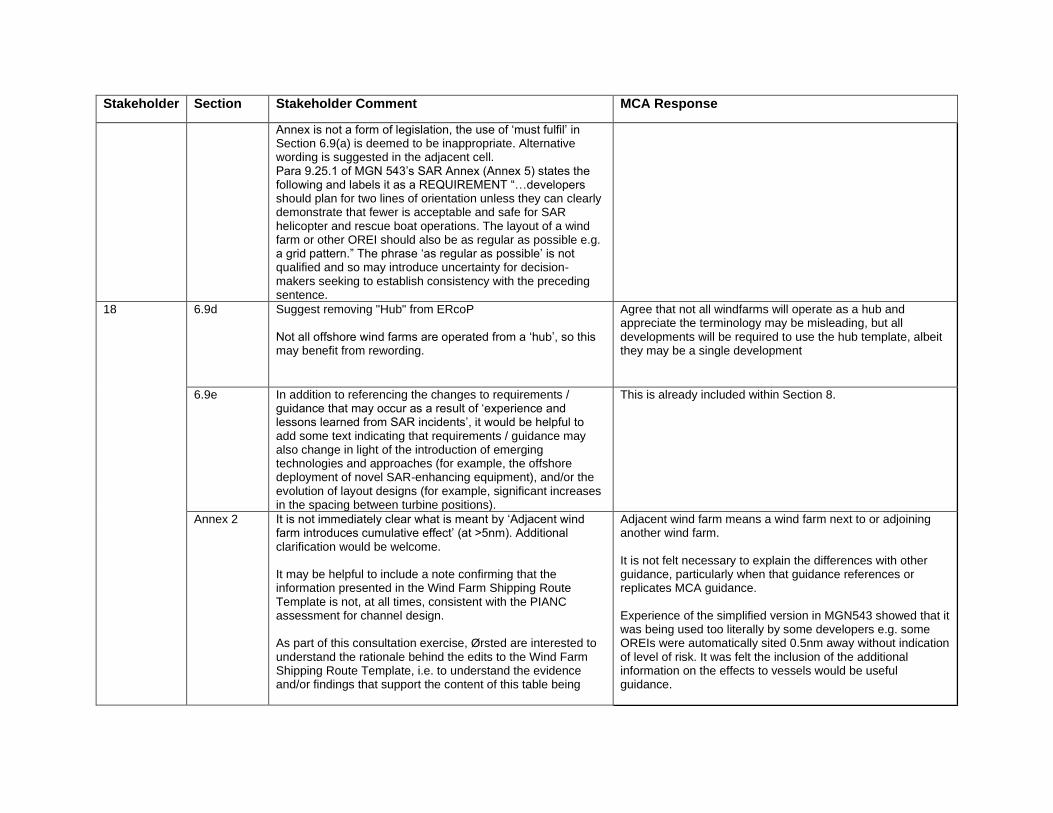
Stakeholder Section Stakeholder Comment MCA Response
Annex is not a form of legislation, the use of ‘must fulfil’ in Section 6.9(a) is deemed to be inappropriate. Alternative wording is suggested in the adjacent cell. Para 9.25.1 of MGN 543’s SAR Annex (Annex 5) states the following and labels it as a REQUIREMENT “…developers should plan for two lines of orientation unless they can clearly demonstrate that fewer is acceptable and safe for SAR helicopter and rescue boat operations. The layout of a wind farm or other OREI should also be as regular as possible e.g. a grid pattern.” The phrase ‘as regular as possible’ is not qualified and so may introduce uncertainty for decision-makers seeking to establish consistency with the preceding sentence.
18 6.9d Suggest removing "Hub" from ERcoP Not all offshore wind farms are operated from a ‘hub’, so this may benefit from rewording.
Agree that not all windfarms will operate as a hub and appreciate the terminology may be misleading, but all developments will be required to use the hub template, albeit they may be a single development
6.9e In addition to referencing the changes to requirements / guidance that may occur as a result of ‘experience and lessons learned from SAR incidents’, it would be helpful to add some text indicating that requirements / guidance may also change in light of the introduction of emerging technologies and approaches (for example, the offshore deployment of novel SAR-enhancing equipment), and/or the evolution of layout designs (for example, significant increases in the spacing between turbine positions).
This is already included within Section 8.
Annex 2 It is not immediately clear what is meant by ‘Adjacent wind farm introduces cumulative effect’ (at >5nm). Additional clarification would be welcome. It may be helpful to include a note confirming that the information presented in the Wind Farm Shipping Route Template is not, at all times, consistent with the PIANC assessment for channel design. As part of this consultation exercise, Ørsted are interested to understand the rationale behind the edits to the Wind Farm Shipping Route Template, i.e. to understand the evidence and/or findings that support the content of this table being
Adjacent wind farm means a wind farm next to or adjoining another wind farm. It is not felt necessary to explain the differences with other guidance, particularly when that guidance references or replicates MCA guidance. Experience of the simplified version in MGN543 showed that it was being used too literally by some developers e.g. some OREIs were automatically sited 0.5nm away without indication of level of risk. It was felt the inclusion of the additional information on the effects to vessels would be useful guidance.
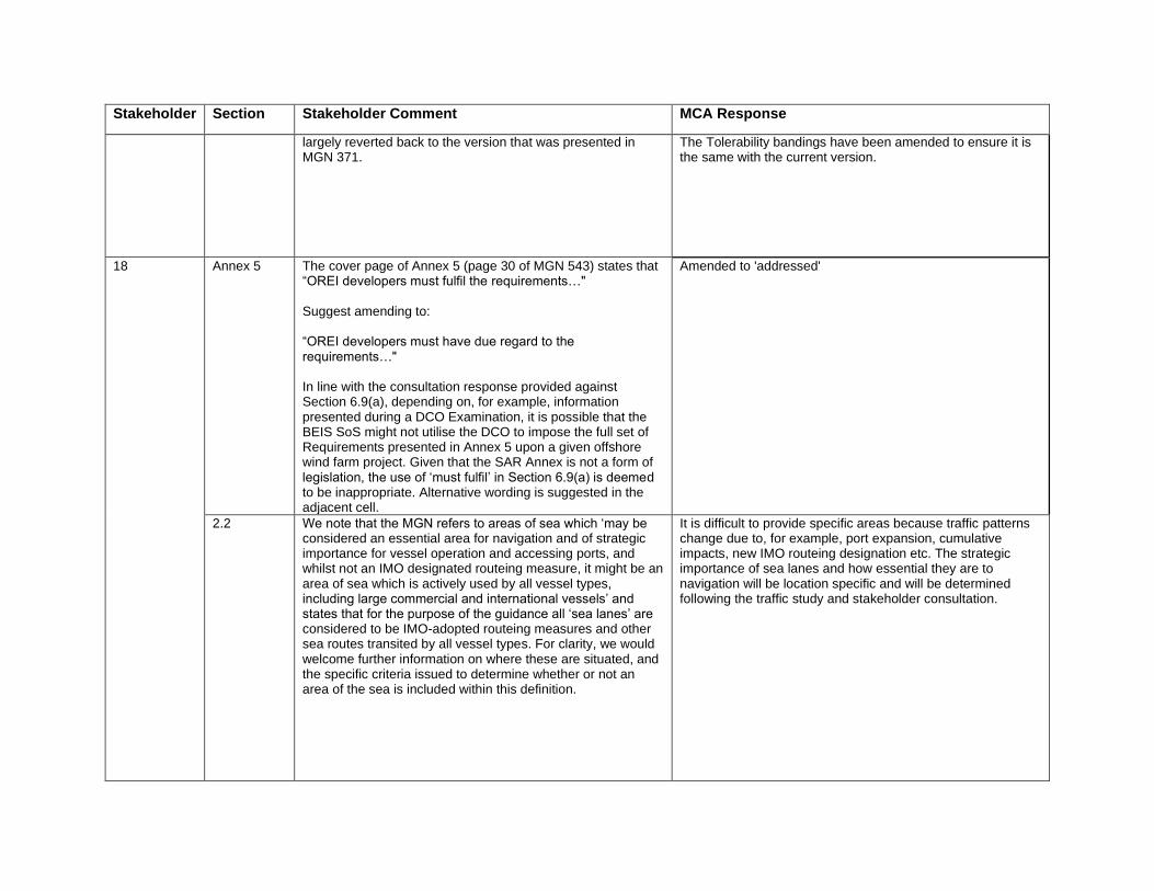
Stakeholder Section Stakeholder Comment MCA Response
largely reverted back to the version that was presented in MGN 371.
The Tolerability bandings have been amended to ensure it is the same with the current version.
18 Annex 5 The cover page of Annex 5 (page 30 of MGN 543) states that “OREI developers must fulfil the requirements…" Suggest amending to: “OREI developers must have due regard to the requirements…" In line with the consultation response provided against Section 6.9(a), depending on, for example, information presented during a DCO Examination, it is possible that the BEIS SoS might not utilise the DCO to impose the full set of Requirements presented in Annex 5 upon a given offshore wind farm project. Given that the SAR Annex is not a form of legislation, the use of ‘must fulfil’ in Section 6.9(a) is deemed to be inappropriate. Alternative wording is suggested in the adjacent cell.
Amended to 'addressed'
2.2 We note that the MGN refers to areas of sea which ‘may be considered an essential area for navigation and of strategic importance for vessel operation and accessing ports, and whilst not an IMO designated routeing measure, it might be an area of sea which is actively used by all vessel types, including large commercial and international vessels’ and states that for the purpose of the guidance all ‘sea lanes’ are considered to be IMO-adopted routeing measures and other sea routes transited by all vessel types. For clarity, we would welcome further information on where these are situated, and the specific criteria issued to determine whether or not an area of the sea is included within this definition.
It is difficult to provide specific areas because traffic patterns change due to, for example, port expansion, cumulative impacts, new IMO routeing designation etc. The strategic importance of sea lanes and how essential they are to navigation will be location specific and will be determined following the traffic study and stakeholder consultation.

Stakeholder Section Stakeholder Comment MCA Response
4.5a The guidance states that “an up to date, traffic survey of the area concerned should be undertaken within 12 months prior to submission of the Environmental Statement. This should include all the vessel types found in the area and total at least 28 days duration but also take account of seasonal variations in traffic patterns and fishing operations. AIS data alone will not constitute an appropriate traffic survey; radar and manual observations will ensure those vessels that are not required to carry and operate AIS are included, and it provides a true reflection of the base line marine traffic”. We would welcome inclusion of the cavate “unless otherwise” agreed within the text of to reflect that in some, specific situations the full survey may not be required where evidence can be provided to support this (i.e. In areas where there is limited non-AIS traffic during the winter period, a case may be made that this data would have little impact on the outcome of the NRA.
New sentence added as 4.5.e to say that developers are advised to discuss traffic survey proposals beforehand

Methodology for Assessing the Navigational Safety and Emergency Response of Offshore Renewable Energy Installations.
Stakeholder Section Stakeholder Comment MCA Response
1 9 Enforcement of Licence Conditions: We note that Section 9 of the NRA Methodology does not contain any information on how licence conditions are enforced following consent. We welcome the recognition that stakeholders should be involved at “all stages of development”(Section 9.3). However, the RYA has noted that licence conditions relating to navigation safety are not always implemented, this is with particular regard to informing recreational users of timing of works and movement of vessels. Recommendation 1: That the NRA Methodology should include guidance indicating that a system for receiving and acting on complaints (with clear contact details) should be provided to enable maritime users to notify the Planning Inspectorate, Marine Scotland, Natural Resources Wales, Marine Management Organisation, Department of Agriculture, Environment and Rural Affairs or DfT/MCA where licence conditions are breached.
A complaints system for breach of marine licence conditions lies outside the purpose of the NRA Methodology document. It's intention is to provide guidence on the pre-consent stage so we suggest this request should be made to the licensing authorities.
Environmental Statements and Navigation Risk Assessment: The RYA has noted a failure by developers to always follow/ include the recommendations of project Navigation Risk Assessments (NRA) or “reinterpreting” the results of the NRA to minimise negative impacts to receptors (human safety) within associated Environmental Statements (ES). This in-turn undermines Section 4.3 of MGN 543. It is our view that Section 2.4 of the NRA Methodology should be revised as follows: Recommendation 2: Wording and emphasis of impacts, recommendations and mitigation within the project application and associated ES should be identical to that of the NRA. The project application, and associated Environmental Impact Assessment (EIA)/ ES should list all the NRA recommendations, with justification for acceptance or rejection of each. If this is not undertaken,then an application should be considered to not have fulfilled the requirements of Section 4.3 of MGN 543.
New sentence added to NRA Methodolody Section 2.4: "The EIA Report should confirm which NRA recommendations are proposed with justification for acceptance or rejection of each."

1 6.1 Residual Impacts and ALARP: Within Section 6.1 of the NRA Methodology, the RYA recommends Residual Impacts and ALARP: Within Section 6.1 of the NRA Methodology, the RYA recommends that: Recommendation 3: The use of terminology concerning “residual impacts” within the ES should be reconciled with ALARP in the NRA so that there is commonality of technical language to demonstrate the relationship between the ES and the NRA.
The level of risk with future traffic and with the OREI in place is addressed in Section 6.2 where it states the change needs to be assessed against ALARP criteria. New sentence added to Section 2.4: "It is recommended to use similar terminology in the EIA Report and NRA to ensure there is a clear understanding on the proposals at the application stage."
6.2 Project Viability: Section 6.2 of the NRA Methodology should establish a minimum acceptable standard for societal concerns with respect to protecting human life. The RYA has noted in one recent large scale tidal power generation project the rejection of the NRA maritime safety mitigation measures within the ES on submission of the application. Rejection was on the basis that mitigation (widening of a navigation channel) would prevent the project from being viable, i.e. protection of human life becomes secondary to project implementation. As a result the ES interpreted the residual impact as being low, this is unacceptable (see Recommendation 3). Recommendation 4: Sections 6.2 and 9.3 of the NRA Methodology should clearly state that there should be a presumption against licence applications being taken forward from the scoping/screening stage, or at submission of the ES, if threats/ impacts to maritime safety and the protection of human life cannot be successfully mitigated.
Each project is dealt with on a case by case basis and it is very difficult to apply a minimum standard for societal risk for all projects. If stakeholders judged societal risk to be unacceptable they must raise their concerns as an objection to the examining and/or licensing authority. We must recognise that project plans can change as it progresses through the EIA and planning processes and that high risk hazards can be discussed prior to consent with the aim of reaching an agreeable position. However, a new sentence has been added to NRA Methodology Section 6.1: "Failure to reach agreement may result in delays or objections from stakeholders within the licensing and consenting process."
2 6.1 [Tolerability of Risk]
It is not made clear that the scores quoted within the two bullet points relate directly to the example risk matrix in Annex C. There are many examples of risk matrices, which use a range of scoring, so the ‘tolerable’ scores and ‘unacceptable’ scores may also vary widely from those quoted.
Both bullet points amended to include: "in the HSE example".
9.2 [list of stakeholders]
We would like this list to include ports as well as port authorities. There are ports which sit within, or outside, of port authorities, which may be directly impacted by an OREI
Added.
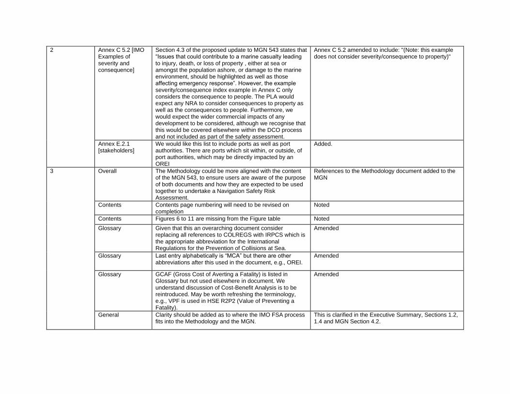
2 Annex C 5.2 [IMO Examples of severity and consequence]
Section 4.3 of the proposed update to MGN 543 states that “Issues that could contribute to a marine casualty leading to injury, death, or loss of property , either at sea or amongst the population ashore, or damage to the marine environment, should be highlighted as well as those affecting emergency response”. However, the example severity/consequence index example in Annex C only considers the consequence to people. The PLA would expect any NRA to consider consequences to property as well as the consequences to people. Furthermore, we would expect the wider commercial impacts of any development to be considered, although we recognise that this would be covered elsewhere within the DCO process and not included as part of the safety assessment.
Annex C 5.2 amended to include: "(Note: this example does not consider severity/consequence to property)"
Annex E.2.1 [stakeholders]
We would like this list to include ports as well as port authorities. There are ports which sit within, or outside, of port authorities, which may be directly impacted by an OREI
Added.
3 Overall The Methodology could be more aligned with the content of the MGN 543, to ensure users are aware of the purpose of both documents and how they are expected to be used together to undertake a Navigation Safety Risk Assessment.
References to the Methodology document added to the MGN
Contents Contents page numbering will need to be revised on completion
Noted
Contents Figures 6 to 11 are missing from the Figure table Noted
Glossary Given that this an overarching document consider replacing all references to COLREGS with IRPCS which is the appropriate abbreviation for the International Regulations for the Prevention of Collisions at Sea.
Amended
Glossary Last entry alphabetically is “MCA” but there are other abbreviations after this used in the document, e.g., OREI.
Amended
Glossary GCAF (Gross Cost of Averting a Fatality) is listed in Glossary but not used elsewhere in document. We understand discussion of Cost-Benefit Analysis is to be reintroduced. May be worth refreshing the terminology, e.g., VPF is used in HSE R2P2 (Value of Preventing a Fatality).
Amended
General Clarity should be added as to where the IMO FSA process fits into the Methodology and the MGN.
This is clarified in the Executive Summary, Sections 1.2, 1.4 and MGN Section 4.2.

3 1.3 We note there is no longer a requirement to consider the decommissioning phase of any development – how does that align with the consenting process? (Note: Decommissioning still mentioned in a few places within the document.)
Additional sentence added to say decommissioning is addressed through the decommissioning programme.
2.3 Could be removed unless a definition of cumulative impacts is provided.
It is important that cumulative impacts are assessed and therefore important to keep this paragraph. It points the reader to the National Policy Statement.
3.2 A more precise definition of large/small scale developments would be useful (perhaps in terms of OREI MW output).
This will depend on the scale of risk it presents which is dependant on characteristics such as size of turbines, size geographically, location etc. There is too much uncertainty to provide a more precise definition so must be on a case by case basis. Developers are encouraged to discuss the NRA approach beforehand.
4.2 It would be useful to establish the frequency and extent of the periodic practice exercises.
Assuming this comment is referring to: 'Set up and periodically exercise an emergency plan', the frequency and extent will be vary according to the developer and project. Further guidance is provided in the Regulatory expectations for Emergency Response Arrangements for the Offshore Renewable Energy Industry document from HSE and MCA - a link has been added in Annex A2.
5.2 Reference to Annex D2 should be included in the statement of methods “Acceptable to Government”.
Added.
6.1 Should it be noted that the risk scores are from the IMO Classification, and other risk scoring systems may be used by developers?
Added.
9.1 Potential for link to be made to the available to the information published by the Better Regulation Task Force.
Amended to Better Regulation Executive. Link added.
Annex A1 Include latest links to all these sources within the table Noted
Annex B Question the use of the word must in the following excerpt as this takes no account of development area or type; in some cases AIS-only may be deemed appropriate (supported by consultation)- “The results of the traffic survey must provide traffic information for the traffic as a whole and for each class of vessel. AIS data alone will not capture all vessel sizes therefore data from appropriate additional sources such as radar must be collected.”
For consistency with MGN 543 updates (Section 4.5a), 'must' replaced with 'should'. The first sentence has been amended to include "with the data available".
Annex D.3.3 The reference to HMCG been removed? HMCG incident datasets are being worked on but it is unlikely it will be possible to localise the data for OREI sites. Given the infrequency of requests it was decided to remove this reference however we will provide an

update when more is known on the availability of datasets.
3 Annex D.3.3 IMO Mandatory Ship Reporting Systems (MSRS) data should be available for casualty analysis.
The supply of MCA data is provided if there is a public interest, but requests made by developers leading to development consent of an OREI would be seen as commercial interests.
Annex D.5.3 Suggestion that the section on Safety Zones to be reinserted as they can be an important risk control measure and are internationally accepted and recognised under UNCLOS?
Reinserted
4 NRA and Risk Assessment 5a
4.13/4.14 refer to the Annex 1 guidance documents on producing an NRA, with the need for hazard logs, mitigation and assessments of ALARP. The guidance on the risk assessment within MGN543 and the accompanying Methodology Document contains a number of limitations which should be either clarified or addressed.
No response required
5b Hazard Log Construction - Previous NRAs we have reviewed have used between 13 and 850 hazards. This balance between specificity and practicality when scoring hazards matters. For instance, the risk of collision is the sum of the risk of collision between fishing boats, plus recreational craft, plus commercial vessels (by type, e.g. tanker, ferry, cargo vessel) etc. Lower absolute hazard scores are achieved with the greater the number of hazards and the hazard log process often does not get aggregated into total risk scores which are far more relevant. This matters if individual hazards are required to be ALARP rather than the total risk of all hazards. Indeed, the subject of aggregate hazard risk is not clearly defined or required in the MGN.
Banding together of hazards does sound a pragmatic and viable solution to analysing large amounts of data however care must be taken to inadvertantly avoid over-simplification by combining low and high risk scenarios. Note the IMO FSA itself is indicative guidance listing various alternates and options for the FSA steps, and bands the incident/accident types together in indicative categories, as: Collision; Contact/allision; Foundered; Fire/explosion; Hull damage; Machinery damage; War loss; Grounding; Other ship accidents; Other oil spills; Personal accidents. Also, there are several standards for risk acceptance criteria, none as yet universally accepted. However, Annex C1 amended to include: The Hazard Log construction and population would largely depend on the geospatial and other complexities of a particular OREI with regard to the navigational risks and any consequential emergency responses. It should include a suitable set of incident scenarios with potential causes and outcomes, to formulate objective evidence which is empirically reproducible where possible. The Hazard Log should, therefore, contain constructs which could: • produce quantitively and qualitatively verifiable hazard scenarios; and

• provide data detailed enough for the next step of evaluation of risk factors.
4 5c Risk Matrix - The risk matrix bandings used in Annex 1 Section C are linked to the International Maritime Organisation (IMO) Formal Safety Assessment (FSA) guidance, however in Methodology Documents (C.5.4) they are incorrectly interpreted and are not those provided by the IMO FSA. It should also be noted that the FSA risk matrix guidance is designed around ship based assessments (using units of per ship year) but not area assessments, such as OREIs. For example, how does one estimate or measure the risk per ship year/per person for vessels passing a discrete OREI? It is recommended that this issue is addressed by the MCA.
C.5.4 amended to say it is an HSE example. Additional sentence added to say the examples are based on ship scenrios and will require application to OREIs.
6a A key outcome of the NRA is defining whether the impact of a development is tolerable, yet the guidance provides no definitions on what constitutes tolerable? This makes it challenging for developers to interpret the results of a NRA or choose whether to proceed with a development, or what risk controls are absolutely necessary. NRA ALARP thresholds have been set by some administrations elsewhere and it is encouraged that MCA adopts the same principle.
It is not recommended within FSA to provide specific numerical values for assessment bandings and tolerability since it can vary according to perspective, proportionality (e.g. QRA may not always be appropriate) and the type of site-specific activity. There is no criterion in IMO to determine acceptability and HSE notes that quantitative unacceptable limits are used with caution due to their complexity and that the quantative predictions might be compared to are frought with uncertainty. If a risk falls below a numerical value then it does not necessarily mean ALARP - further reductions may be possible.

4 6b At the moment no baseline assessment of navigation hazard risk exists for UK waters (this is however required by SOLAS Chapter V regulations for coastal states, which are required to assess the need for SOLAS Chapter V regulations based on the volumes of traffic and the degree of risk) therefore in many cases the OREI NRA is the first assessment of navigation risk within a particular area. This means that there is no accepted definition of baseline risk against which the OREI can be fairly judged against and increases possibility of unfounded challenge.
SOLAS V, in this context is a regulatory transposition of UK’s acceptance to the SOLAS as a whole, which is based on the regulatory impact assessment (both operational and economical) – there’s no provision or need, therefore, to risk assess it as such. In any case, it’s a treaty reference with various express and implied provisions both on the Contracting State (UK) and ships under its flag, which were based on general maritime navigation safety compelling need. One doesn’t risk assess SOLAS or any of its chapters - it’s whole inception, as with any such treaties, is based on alleviating risks so identified. So, it’s an answer to an risk assessment not cause or subject to a risk assessment. To date, MCA is not aware of OREI NRA baseline risk being the subject of challenge within the planning process e.g. via PINS. MCA would not recommend use of a generic risk assessment for OREIs without consideration of site and application specific information.
6c Typically, the hazard bandings of the NRA are used to determine ALARP per hazard, which broadly equates to one fatality per 10 years as the threshold for hazards to be unacceptable (as per Anatec, Marico and NASH risk matrices). By comparison, on average there are 7 fatalities aboard merchant ships in UK waters per year from all accident types / causes. Therefore, the baseline risk in any relatively small OREI study area is extremely low, as is even lower if limiting it to navigation hazards such as contacts, collision and groundings that might, quite rightly be influenced by the introduction of OREIs. Therefore, for any single development to achieve unacceptable risk scores, it would require a very significant increase in risk by many orders of magnitude on the baseline - this imbalance needs to be addressed in the MGN.
MCA notes that the introduction of an OREI will present varying levels of additional risk according to the charateristics of the project and location. In addition to baseline risk scores, MCA expects consultation with relevant stakeholders, to agree risk scores, including the proposed risk control measures to reduce it to acceptable levels. Each project will be assessed on a case by case basis.
6d Additionally, NASH are aware of no serious incidents involving OWFs that do not involve Wind Farm Support Vessels in UK waters. Given that there are >200 years of exposure collectively between UK OWFs, the risk of an incident per individual development is extremely low, and likely orders of magnitude lower than within ports/harbours or oil and gas fields, many of which have lower levels of assessment compared to OREI requirements.
Noted

4 6e The HSE guidance is referenced which presents risk per person, this is challenging in determining who is exposed to risk and also the analysis in the point above demonstrates that the absolute baseline risk is extremely low anyway.
Noted
6f In addition, the reliance on a hazard log to assess risk per hazard is flawed and a greater requirement for establishing the total cumulative risk scores of all hazards should be mandated which avoid dilution of risk scores with increasing numbers of hazards.
The use of cumulative risk scores is an available method to use but it cannot be mandated as the best approach should be taken depending on the complexity and site specific information.
6g Judgements on risk should be also absolute and not relative. A development that increases risk in a relatively safe area by 2x, or even 10x, should be judged tolerable if the new risk level does not exceed the stated acceptable level. This increases the importance in defining tolerable thresholds and requires that standardised units of measurement should be defined (related to vessel transit hours).
It is not recommended within FSA to provide specific numerical values for assessment bandings and tolerability since it can vary according to perspective, proportionality (e.g. QRA may not always be appropriate) and the type of site-specific activity. There is no criterion in IMO to determine acceptability and HSE notes that quantitative unacceptable limits are used with caution due to their complexity and the quantative predictions might be compared to are frought with uncertainty. If a risk falls below a numerical value then it does not necessarily mean ALARP - further reductions may be possible.
6h Ultimately, without a consistent approach to defining what constitutes tolerable navigational risk, inconsistencies between developments, ports and coastal waters would exist that might unfairly penalise OREIs.
A developer will look to gain agreement with stakeholders that the toleralibity level is acceptable including agreement of the risk controls list.
5 Track Changes Comments and amendments in the Methodology document using Track Changes
Suggested amendments accepted.
6 9.2 Reference added to DAERA, Northern Ireland Suggested amendments accepted.

7 Acknowledgements The Acknowledgements section states that “This version was produced by MCA in co-operation with those individuals and organisations who contributed useful feedback during the consultation period through the Nautical and Offshore Renewable Energy Liaison (NOREL) group.” It is not clear whether this wording implies full agreement (re the content of the Methodology document) from all NOREL members. It may make sense to tweak this sentence in the absence of full agreement.
We are be mindful that full agreement may not be possible. This consultation exercise has provided navigation stakeholders, developers and navigation consultants with the opportinity to provide feedback and MCA has tried to accommodate suggested amendments wherever possible. MCA is content with the current wording of the Acknowlegements section.
2.4 Given that the scope of the Methodology document covers the evaluation of final layouts at the post-consent (i.e. pre-construction) phase (as well as the evaluation of indicative layouts at the pre-consent phase), it may make sense to tweak the last part of this sentence.
The Methodology document does not cover the evaluation of final layouts in the post-consent stage so it is not necessary to amend this section.
4.2 It is understood that a given offshore wind farm consent is tied to versions of relevant MGN documents that are referenced in that consent, and extant at the time that consent is awarded. The owners of a given offshore wind farm do not have control over the content of future MGN revisions and cannot budget for unknown retrospective requirements that may be included in future MGN documents. The text should be tweaked to reflect this.
MCA would expect the current version(s) of its published guidance to be taken into account and would not wish for outdated guidance to be followed in its stead. Any retrospective requirements made on OREI developers will be discussed beforehand.
5.4 - lists four FSA steps as bullet points under ‘Stage 4’.
Further to the NOREL Technical Working Group meeting held on 05/03/2020, in addition to reintroducing the five-step FSA flow-diagram at an appropriate point within the Methodology document, it may also make sense to reference the full five-step FSA process here.
Amended
9.3 It may be helpful to reference BEIS in Section 9.3. Amended
Annex D.3.3 Some text highlighting the availability of HMCG information has been deleted. The information referenced in the deleted text can provide very useful input when it comes to assessing the potential impact of offshore wind farms on SAROPS. If possible, it would be helpful to reinstate some, or all, of the deleted text.
HMCG incident datasets are being worked on but it is unlikely it will be possible to localise the data for OREI sites. Given the infrequency of requests it was decided to remove this reference however we will provide an update when more is known on the availability of datasets.
General A number of references to ATBA’s have been deleted from the Methodology document. Given that ATBA’s are listed as a potential risk mitigation measure in Section 4.14 of MGN 543, it may make sense to also reincorporate a reference to ATBA’s in the Methodology document.
There are two references in the 2013 version. First reference in Table 29 reinstated

8 5.4 We note that Figure 2 appears to have been removed from the consultation draft. We would welcome clarification on the basis for this, and whether the information can be found in another section of the MGN.
This was a duplication of the table in Section 7 which remains.
7.3 The guidance helpfully sets out that submission and the associated annexes must be suitable for electronic circulation. We would ask that the Guidance and associated methodology also recognises the potential for digital Environmental Impact Assessment (EIA) submissions to facilitate better data management and more user-friendly Environmental Statement ‘published’ in a digital and interactive format similar to a website. The use of a wider range of media to communicate the necessary information will allow for improved accessibility and ultimately more effective consultation and examination of the development consent applications.
Amended to include other forms of submissions.
B.3.7 Table 10 Vessel Types involved in Navigation Activities
We would suggest that the table is amended so that Cargo and Passenger ships are separated due to risk type, rather than as Large and Medium vessels. We note that this is guidance and we will therefore continue to present data according to risk.
Noted. Table amended to be more consistent with SOLAS i.e. Medium/Large Vessel categories removed and replaced with Cargo and Passenger
D.3.3 Sources of Real World Information.
We note that the section entitled ‘HM Coastguard’ has been removed from the draft subject to further review. We would ask that confirmation is given as to whether this will be made available for review within the second consultation stage.
HMCG incident datasets are being worked on but it is unlikely it will be possible to localise the data for OREI sites. Given the infrequency of requests it was decided to remove this reference however we will provide an update when more is known on the availability of datasets.


![Bioinformatics - Rutgers Universitychem.rutgers.edu/~kyc/Teaching/Files/543-05/543-24.pdf[3] Precise models of signal transduction pathways;ability to predict cellular responses to](https://img.pdfslide.us/doc/110x75/5f91e8bd40f4f5540f059921/bioinformatics-rutgers-kycteachingfiles543-05543-24pdf-3-precise-models.jpg)