Embed Size (px)
Citation preview
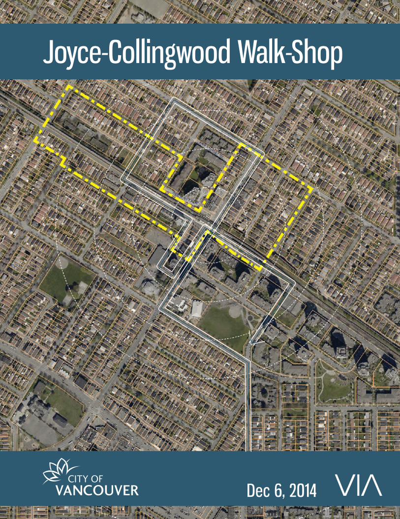
Joyce-Collingwood Walk-Shop
Dec 6, 2014
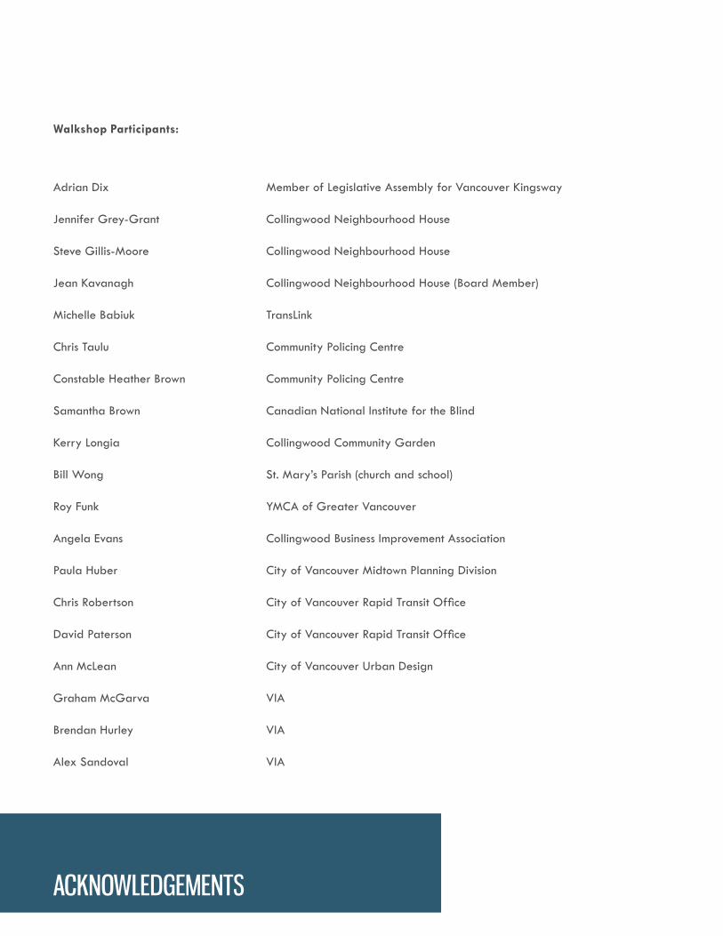
Walkshop Participants:
Adrian Dix Member of Legislative Assembly for Vancouver Kingsway
Jennifer Grey-Grant Collingwood Neighbourhood House
Steve Gillis-Moore Collingwood Neighbourhood House
Jean Kavanagh Collingwood Neighbourhood House (Board Member)
Michelle Babiuk TransLink
Chris Taulu Community Policing Centre
Constable Heather Brown Community Policing Centre
Samantha Brown Canadian National Institute for the Blind
Kerry Longia Collingwood Community Garden
Bill Wong St. Mary’s Parish (church and school)
Roy Funk YMCA of Greater Vancouver
Angela Evans Collingwood Business Improvement Association
Paula Huber City of Vancouver Midtown Planning Division
Chris Robertson City of Vancouver Rapid Transit Office
David Paterson City of Vancouver Rapid Transit Office
Ann McLean City of Vancouver Urban Design
Graham McGarva VIA
Brendan Hurley VIA
Alex Sandoval VIA
ACKNOWLEDGEMENTS
Collingwood
Park
Melbourne
Park
Gaston Park
Foster
Park
Wellington Ave
Queens Ave
Clive Ave
McH
ardy
St
Ann
St
Vanness Ave
Crowley Dr
Joyc
e St
Lin
co
ln S
t
Rub
y St
Aber
dee
n St
Hoy
St
McK
inno
n St
Marmion Ave
Austrey Ave
Cec
il St
Euclid Ave
Vanness Ave
Kingsway
School Ave
Har
old
St
Wes
sex
St
Sen
lac
St
Kingsway
Ob
en
St
Me
lbo
urn
e S
tTy
ne S
t
Church St
Cherry St
Archimedes St
Jo
yce S
t
Ab
erd
een
St
Joyc
e St
400 m
800 m
Alternate routeQuick view of lane betweencommercial and single-family homes
KINGSWAYCONTINENTAL
Return for lunch/de-brief
Quick view of single-family areaadjacent to multi-family
JOYCE-COLLINGWOOD STATIONPRECINCT REVIEW
Walkshop | December 6, 2014
Quick view of lane between commercial and multi-family
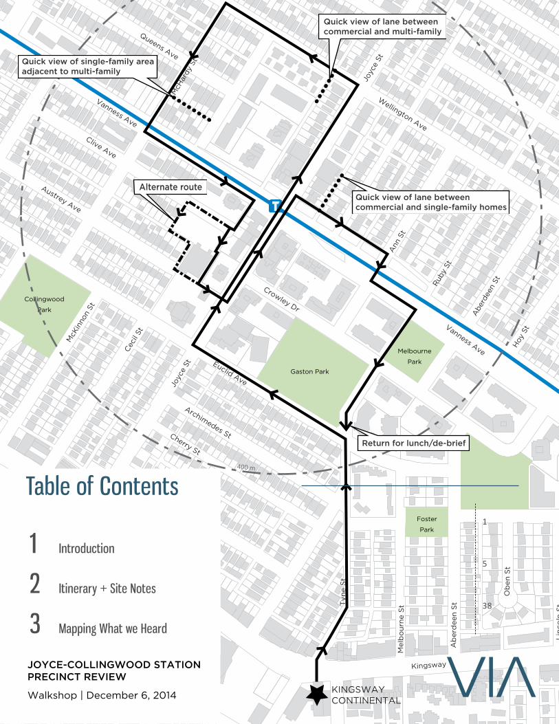
Table of Contents
1 Introduction
2 Itinerary + Site Notes
3 Mapping What we Heard
1
5
38
Joyce-Collingwood Walk-Shop
1 VIA ARCHITECTURE
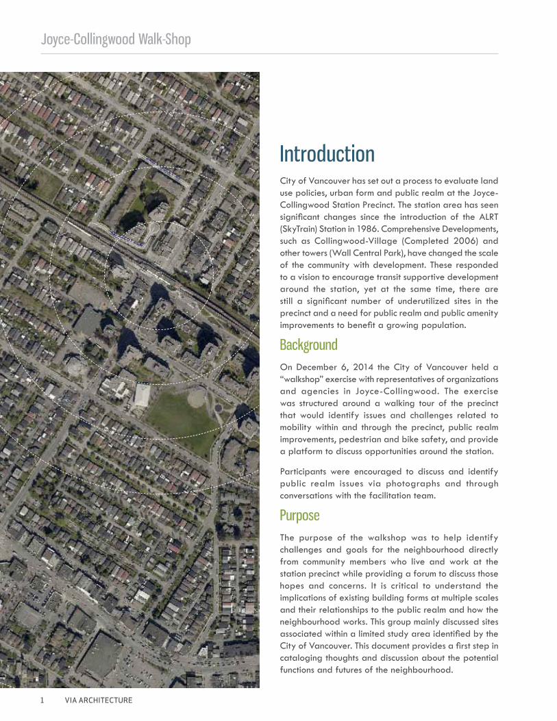
City of Vancouver has set out a process to evaluate land use policies, urban form and public realm at the Joyce-Collingwood Station Precinct. The station area has seen significant changes since the introduction of the ALRT (SkyTrain) Station in 1986. Comprehensive Developments, such as Collingwood-Village (Completed 2006) and other towers (Wall Central Park), have changed the scale of the community with development. These responded to a vision to encourage transit supportive development around the station, yet at the same time, there are still a significant number of underutilized sites in the precinct and a need for public realm and public amenity improvements to benefit a growing population.
Background On December 6, 2014 the City of Vancouver held a “walkshop” exercise with representatives of organizations and agencies in Joyce-Collingwood. The exercise was structured around a walking tour of the precinct that would identify issues and challenges related to mobility within and through the precinct, public realm improvements, pedestrian and bike safety, and provide a platform to discuss opportunities around the station.
Participants were encouraged to discuss and identify public realm issues via photographs and through conversations with the facilitation team.
Purpose
The purpose of the walkshop was to help identify challenges and goals for the neighbourhood directly from community members who live and work at the station precinct while providing a forum to discuss those hopes and concerns. It is critical to understand the implications of existing building forms at multiple scales and their relationships to the public realm and how the neighbourhood works. This group mainly discussed sites associated within a limited study area identified by the City of Vancouver. This document provides a first step in cataloging thoughts and discussion about the potential functions and futures of the neighbourhood.
Introduction
Aerial
SCALE 1:4000
500m100m
Joyce Collingwood Station Area
Joyce-Collingwood Walkshop
VIA ARCHITECTURE 2
Introduction
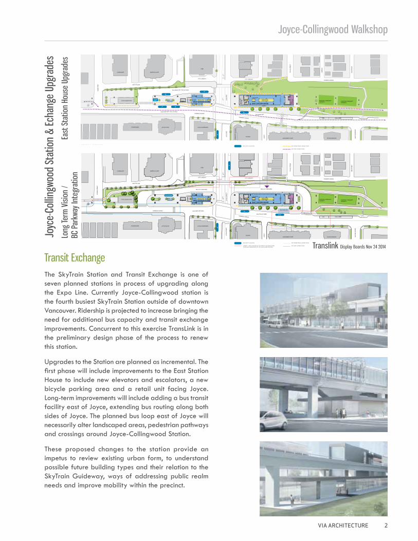
Transit Exchange The SkyTrain Station and Transit Exchange is one of seven planned stations in process of upgrading along the Expo Line. Currently Joyce-Collingwood station is the fourth busiest SkyTrain Station outside of downtown Vancouver. Ridership is projected to increase bringing the need for additional bus capacity and transit exchange improvements. Concurrent to this exercise TransLink is in the preliminary design phase of the process to renew this station.
Upgrades to the Station are planned as incremental. The first phase will include improvements to the East Station House to include new elevators and escalators, a new bicycle parking area and a retail unit facing Joyce. Long-term improvements will include adding a bus transit facility east of Joyce, extending bus routing along both sides of Joyce. The planned bus loop east of Joyce will necessarily alter landscaped areas, pedestrian pathways and crossings around Joyce-Collingwood Station.
These proposed changes to the station provide an impetus to review existing urban form, to understand possible future building types and their relation to the SkyTrain Guideway, ways of addressing public realm needs and improve mobility within the precinct.
Date: Nov 24, 2014 | Size: 36"x 24" | Scale: 1:1233514_Joyce-Collingwood_OpenHouse_DisplayBoards_cmp04invisioncreative.ca
While we do our best to ensure accuracy in our work, it is the responsibility of the client to thoroughly proof-read all content, images and information on this proof. Invision Creative Studio Inc. is not responsible for any errors or discrepancies after approval of this proof.09
28
41/43
Handy DART
WEST STATION HOUSEEAST STATION HOUSE
41
2643
Handy DART
28
27 28
26
27
WEST STATION HOUSEEAST STATION HOUSE
Joyce–Collingwood Station & Exchange UpgradesLong Term Vision/BC Parkway Integration
Upgrades to the East Station House will begin the Summer of 2015.
Building a sustainable transportation future together.Bâtissons ensemble un réseau de transport durable.
Date: Nov 24, 2014 | Size: 36"x 24" | Scale: 1:1233514_Joyce-Collingwood_OpenHouse_DisplayBoards_cmp04invisioncreative.ca
While we do our best to ensure accuracy in our work, it is the responsibility of the client to thoroughly proof-read all content, images and information on this proof. Invision Creative Studio Inc. is not responsible for any errors or discrepancies after approval of this proof.09
Joyce–Collingwood Station & Exchange UpgradesEast Station House Upgrades
28
41/43
Handy DART
WEST STATION HOUSEEAST STATION HOUSE
41
2643
Handy DART
28
27 28
26
27
WEST STATION HOUSEEAST STATION HOUSE
The upgrades included in the long-term vision will be constructed as a separate project when necessary funding is secured.
Building a sustainable transportation future together.Bâtissons ensemble un réseau de transport durable.
Joyc
e-Co
llingw
ood
Stat
ion
& Ec
hang
e Up
grad
es
East
Sta
tion
Hous
e Up
grad
es
Translink Display Boards Nov 24 2014
Long
Term
Visi
on /
BC P
arkw
ay In
tegr
atio
n
Joyce-Collingwood Walk-Shop
3 VIA ARCHITECTURE
NorquayPark
Earles Park
CollingwoodPark
Price Park
CarletonPark
Cariboo Park
MelbournePark
Slocan Park
Gaston Park
FosterPark
JOYCE-COLLINGWOODSKYTRAIN STATION
29TH AVENUESKYTRAIN STATION
Moscrop St
Tanner St
Wellington Ave
Price St
Queens Ave
Clive Ave
McH
ardy
St
Ann St
Duke St
Euclid Ave
E 29th Ave
Mos
s St
Fairm
ont S
t
Killa
rney
St
Burs
ill St
Vanness Ave
Rupe
rt St
Chat
ham
StMan
or St
Killa
rney
St
Spen
cer S
t
E 43rd Ave
Wal
es S
t
Todd
St
Ravi
ne St
Crowley Dr
Joyc
e St
Orm
idal
e St
Linc
oln
St
Ruby
St
Aberd
een
St
Hoy St
Rae Ave
Monmouth Ave
Boun
dary
Roa
d
Pent
icto
n St
McK
inno
n St
Marmion Ave
Austrey Ave
Cecil
St
Euclid Ave
Vanness Ave
Kingsway
School Ave
Harol
d St
Wes
sex S
t
Senl
ac St Kingsway
Obe
n St
Mel
bour
ne S
tTyne
St
Church St
Cherry St
Archimedes St
Colle
ge S
t
Sloc
an St
Earle
s St
Kingsway
E 37th Ave
E 34th Ave
Ward St
Cheyenne Ave
Horley St
Earle
s St
Fairm
ont S
t
Duche
ss St
E 29th Ave
Rhod
es S
t
Cham
bers
St
E 42nd Ave
E 41st Ave
E 38th Ave
Dun
dee
St
Killa
rney
St
Taun
ton
St
McH
ardy
St
School Ave
Rupe
rt S
t
Ivanhoe St
E 41st Ave
Joyc
e St
Kerr
St
McK
inno
n St
Lanc
aste
r St
Abe
rdee
n St
E 28th Ave
Atli
n St
2
1
3
4
5
6
7
910
8
1112
13
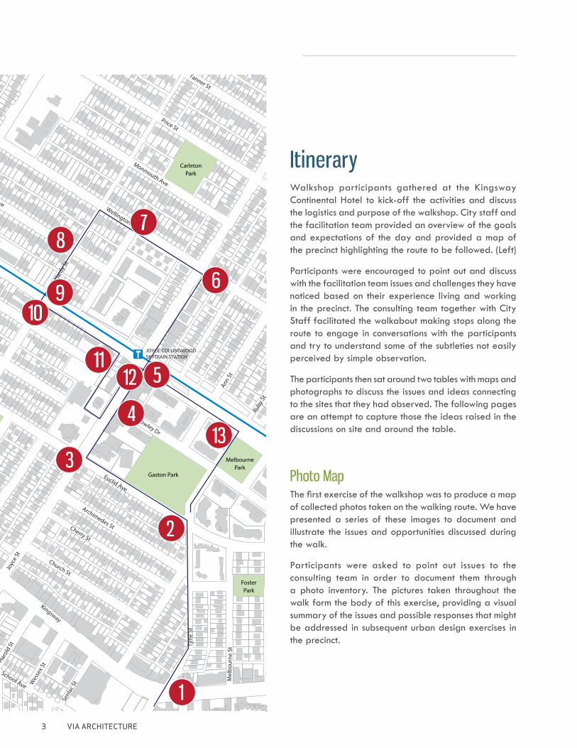
Walkshop participants gathered at the Kingsway Continental Hotel to kick-off the activities and discuss the logistics and purpose of the walkshop. City staff and the facilitation team provided an overview of the goals and expectations of the day and provided a map of the precinct highlighting the route to be followed. (Left)
Participants were encouraged to point out and discuss with the facilitation team issues and challenges they have noticed based on their experience living and working in the precinct. The consulting team together with City Staff facilitated the walkabout making stops along the route to engage in conversations with the participants and try to understand some of the subtleties not easily perceived by simple observation.
The participants then sat around two tables with maps and photographs to discuss the issues and ideas connecting to the sites that they had observed. The following pages are an attempt to capture those the ideas raised in the discussions on site and around the table.
Itinerary
Photo MapThe first exercise of the walkshop was to produce a map of collected photos taken on the walking route. We have presented a series of these images to document and illustrate the issues and opportunities discussed during the walk.
Participants were asked to point out issues to the consulting team in order to document them through a photo inventory. The pictures taken throughout the walk form the body of this exercise, providing a visual summary of the issues and possible responses that might be addressed in subsequent urban design exercises in the precinct.
Joyce-Collingwood Walkshop
VIA ARCHITECTURE 4
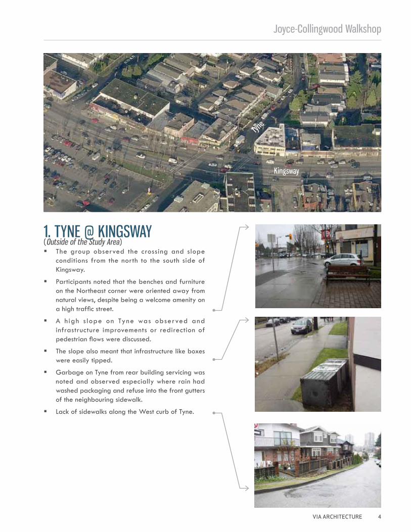
1. TYNE @ KINGSWAY
Kingsway
Tyne
� The group observed the crossing and slope conditions from the north to the south side of Kingsway.
� Participants noted that the benches and furniture on the Northeast corner were oriented away from natural views, despite being a welcome amenity on a high traffic street.
� A h igh s lope on Tyne was observed and infrastructure improvements or redirection of pedestrian flows were discussed.
� The slope also meant that infrastructure like boxes were easily tipped.
� Garbage on Tyne from rear building servicing was noted and observed especially where rain had washed packaging and refuse into the front gutters of the neighbouring sidewalk.
� Lack of sidewalks along the West curb of Tyne.
(Outside of the Study Area)
Joyce-Collingwood Walk-Shop
5 VIA ARCHITECTURE
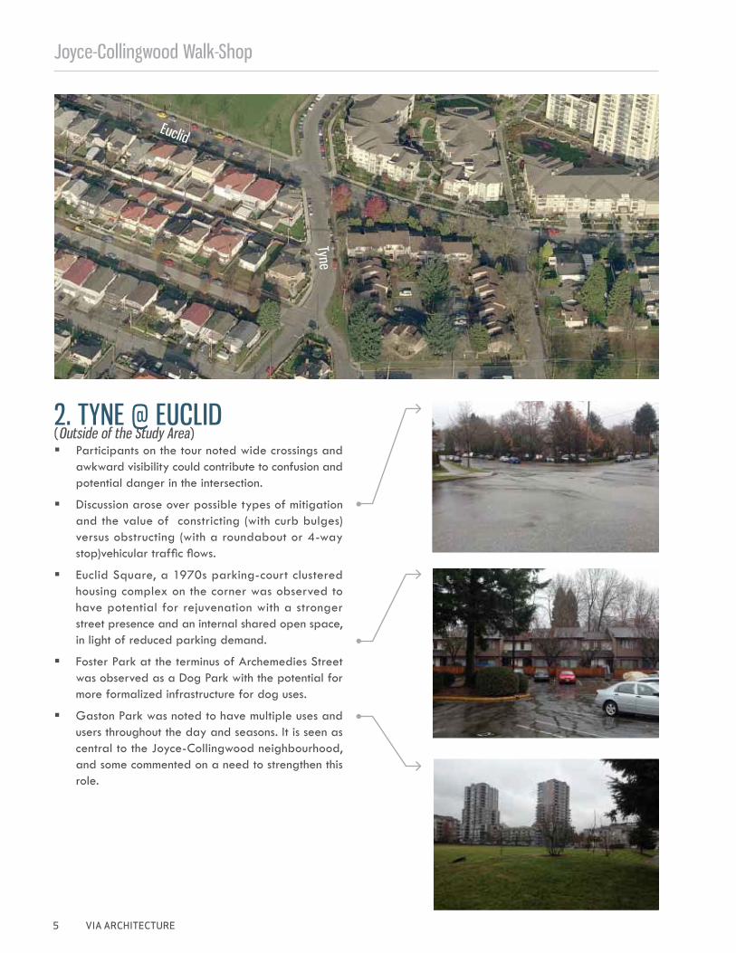
2. TYNE @ EUCLID � Participants on the tour noted wide crossings and
awkward visibility could contribute to confusion and potential danger in the intersection.
� Discussion arose over possible types of mitigation and the value of constricting (with curb bulges) versus obstructing (with a roundabout or 4-way stop)vehicular traffic flows.
� Euclid Square, a 1970s parking-court clustered housing complex on the corner was observed to have potential for rejuvenation with a stronger street presence and an internal shared open space, in light of reduced parking demand.
� Foster Park at the terminus of Archemedies Street was observed as a Dog Park with the potential for more formalized infrastructure for dog uses.
� Gaston Park was noted to have multiple uses and users throughout the day and seasons. It is seen as central to the Joyce-Collingwood neighbourhood, and some commented on a need to strengthen this role.
Euclid
Tyne
(Outside of the Study Area)
Joyce-Collingwood Walkshop
VIA ARCHITECTURE 6
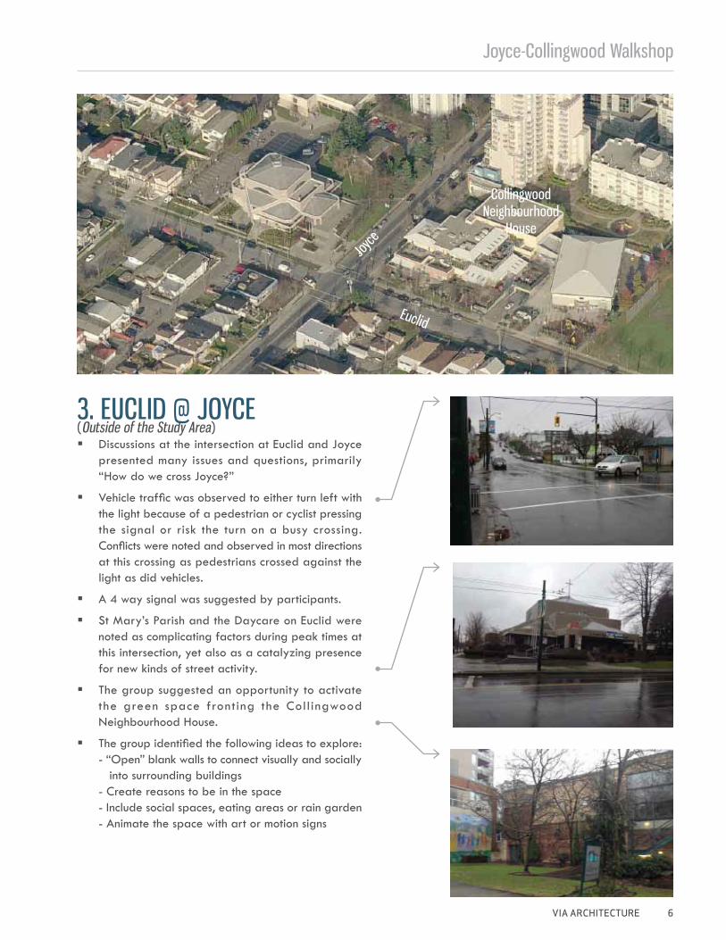
3. EUCLID @ JOYCE
Euclid
Joyce
� Discussions at the intersection at Euclid and Joyce presented many issues and questions, primarily “How do we cross Joyce?”
� Vehicle traffic was observed to either turn left with the light because of a pedestrian or cyclist pressing the signal or risk the turn on a busy crossing. Conflicts were noted and observed in most directions at this crossing as pedestrians crossed against the light as did vehicles.
� A 4 way signal was suggested by participants.
� St Mary’s Parish and the Daycare on Euclid were noted as complicating factors during peak times at this intersection, yet also as a catalyzing presence for new kinds of street activity.
� The group suggested an opportunity to activate the green space fronting the Coll ingwood Neighbourhood House.
� The group identified the following ideas to explore: - “Open” blank walls to connect visually and socially into surrounding buildings - Create reasons to be in the space - Include social spaces, eating areas or rain garden - Animate the space with art or motion signs
Collingwood Neighbourhood
House
(Outside of the Study Area)
Joyce-Collingwood Walk-Shop
7 VIA ARCHITECTURE
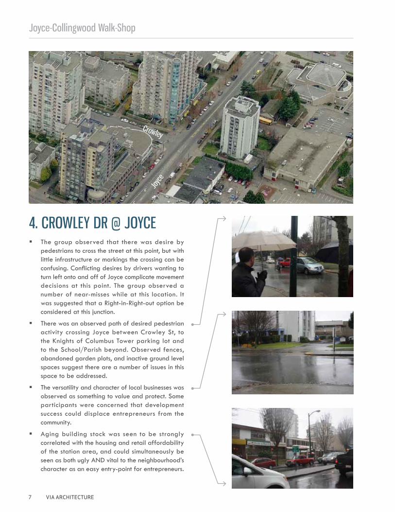
4. CROWLEY DR @ JOYCE
Crowley
Joyc
e
� The group observed that there was desire by pedestrians to cross the street at this point, but with little infrastructure or markings the crossing can be confusing. Conflicting desires by drivers wanting to turn left onto and off of Joyce complicate movement decisions at this point. The group observed a number of near-misses while at this location. It was suggested that a Right-in-Right-out option be considered at this junction.
� There was an observed path of desired pedestrian activity crossing Joyce between Crowley St, to the Knights of Columbus Tower parking lot and to the School/Parish beyond. Observed fences, abandoned garden plots, and inactive ground level spaces suggest there are a number of issues in this space to be addressed.
� The versatility and character of local businesses was observed as something to value and protect. Some participants were concerned that development success could displace entrepreneurs from the community.
� Aging building stock was seen to be strongly correlated with the housing and retail affordability of the station area, and could simultaneously be seen as both ugly AND vital to the neighbourhood’s character as an easy entry-point for entrepreneurs.
Joyce-Collingwood Walkshop
VIA ARCHITECTURE 8
Vann
ess
Joyc
e-Coll
ingwoo
d Stat
ion
Joyce
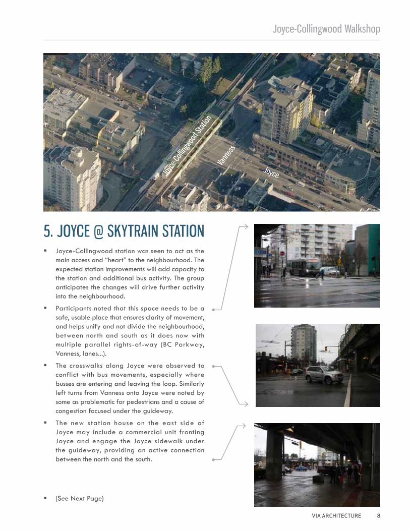
5. JOYCE @ SKYTRAIN STATION � Joyce-Collingwood station was seen to act as the
main access and “heart” to the neighbourhood. The expected station improvements will add capacity to the station and additional bus activity. The group anticipates the changes will drive further activity into the neighbourhood.
� Participants noted that this space needs to be a safe, usable place that ensures clarity of movement, and helps unify and not divide the neighbourhood, between north and south as it does now with multiple parallel rights-of-way (BC Parkway, Vanness, lanes...).
� The crosswalks along Joyce were observed to conflict with bus movements, especially where busses are entering and leaving the loop. Similarly left turns from Vanness onto Joyce were noted by some as problematic for pedestrians and a cause of congestion focused under the guideway.
� The new station house on the east s ide of Joyce may include a commercial unit fronting Joyce and engage the Joyce sidewalk under the guideway, providing an active connection between the north and the south.
� (See Next Page)
Joyce-Collingwood Walk-Shop
9 VIA ARCHITECTURE
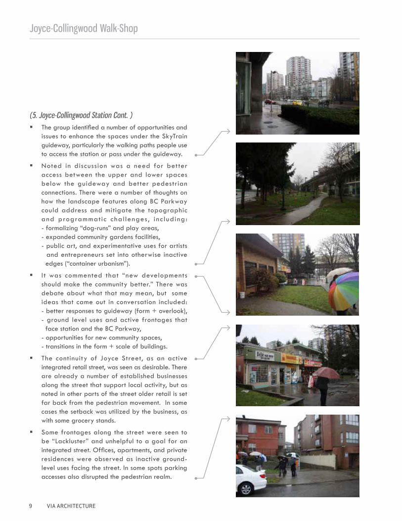
(5. Joyce-Collingwood Station Cont. ) � The group identified a number of opportunities and
issues to enhance the spaces under the SkyTrain guideway, particularly the walking paths people use to access the station or pass under the guideway.
� Noted in discussion was a need for bet ter access between the upper and lower spaces below the guideway and better pedestrian connections. There were a number of thoughts on how the landscape features along BC Parkway could address and mitigate the topographic and programmatic c hal lenges , i n c l uding: - formalizing “dog-runs” and play areas, - expanded community gardens facilities, - public art, and experimentative uses for artists and entrepreneurs set into otherwise inactive edges (“container urbanism”).
� I t was commented that “new developments should make the community better.” There was debate about what that may mean, but some ideas that came out in conversation included: - better responses to guideway (form + overlook), - ground level uses and active frontages that face station and the BC Parkway, - opportunities for new community spaces, - transitions in the form + scale of buildings.
� The continuity of Joyce Street, as an active integrated retail street, was seen as desirable. There are already a number of established businesses along the street that support local activity, but as noted in other parts of the street older retail is set far back from the pedestrian movement. In some cases the setback was utilized by the business, as with some grocery stands.
� Some frontages along the street were seen to be “Lackluster” and unhelpful to a goal for an integrated street. Offices, apartments, and private residences were observed as inactive ground-level uses facing the street. In some spots parking accesses also disrupted the pedestrian realm.
Joyce-Collingwood Walkshop
VIA ARCHITECTURE 10
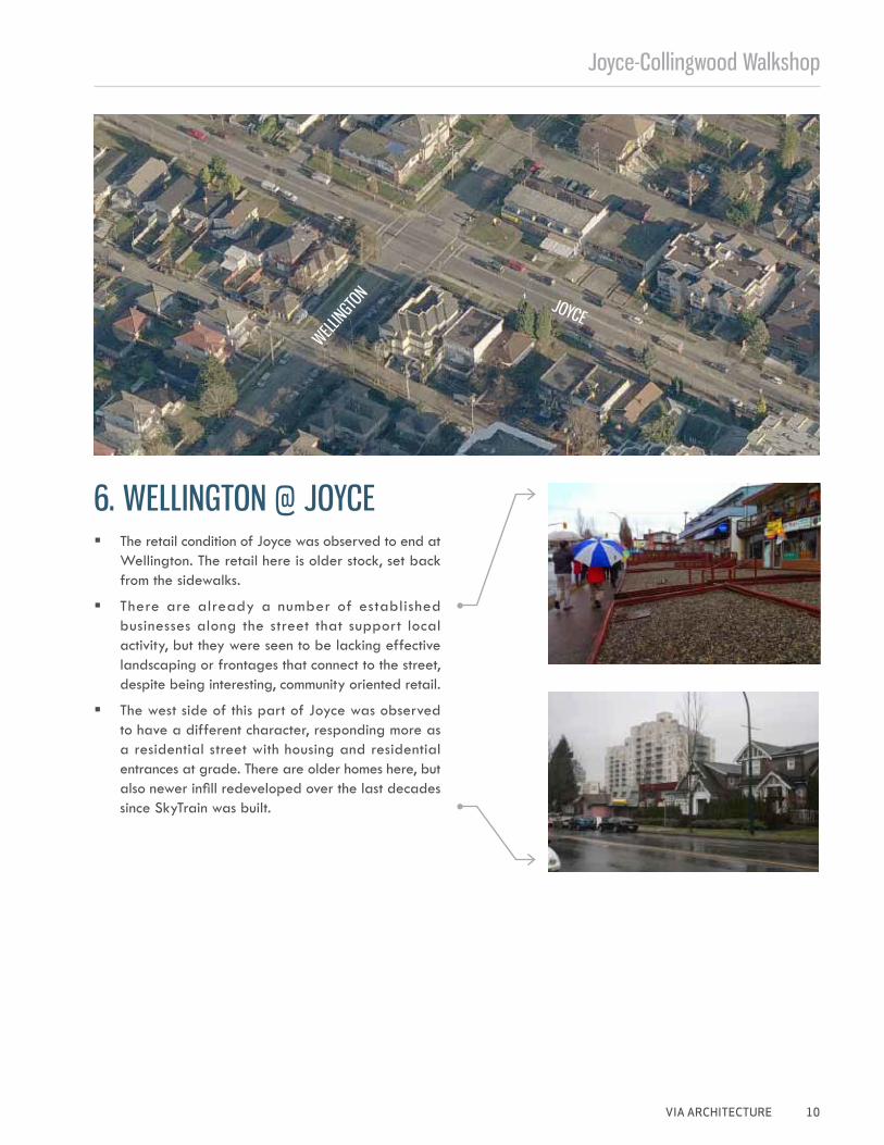
6. WELLINGTON @ JOYCE
JOYCEWELL
INGTO
N
� The retail condition of Joyce was observed to end at Wellington. The retail here is older stock, set back from the sidewalks.
� There are already a number of established businesses along the street that support local activity, but they were seen to be lacking effective landscaping or frontages that connect to the street, despite being interesting, community oriented retail.
� The west side of this part of Joyce was observed to have a different character, responding more as a residential street with housing and residential entrances at grade. There are older homes here, but also newer infill redeveloped over the last decades since SkyTrain was built.
Joyce-Collingwood Walk-Shop
11 VIA ARCHITECTURE
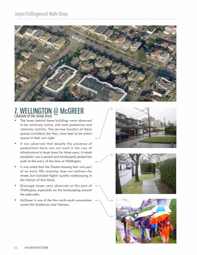
7. WELLINGTON @ McGREER
Wellington
McGree
r
� The lanes behind these buildings were observed to be relatively active, with both pedestrian and vehicular activity. This service function of these spaces is evident, but they were seen to be urban spaces in their own right.
� It was observed that despite the presence of pedestrians there was not much in the way of infrastructure in those lanes for those users. A noted exception was a paved and landscaped pedestrian path at the entry of the lane at Wellington.
� It was noted that the Cluster-housing that was part of an early 90s rezoning does not address the street, but included higher quality landscaping in the interior of that block.
� Drainage issues were observed on this part of Wellington, especially on the landscaping around the sidewalks.
� McGreer is one of the few north-south connections across the Guideway and Vanness.
(Outside of the Study Area)
Joyce-Collingwood Walkshop
VIA ARCHITECTURE 12
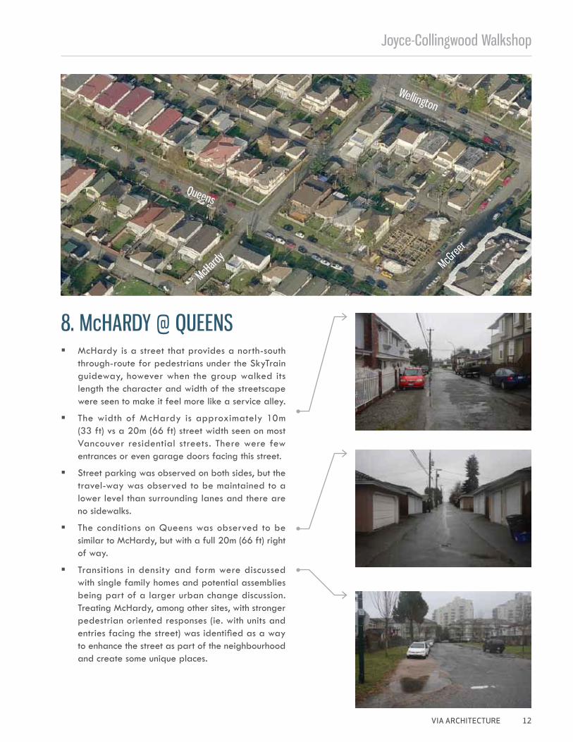
8. McHARDY @ QUEENS
Queens
McHard
y
Wellington
McGree
r
� McHardy is a street that provides a north-south through-route for pedestrians under the SkyTrain guideway, however when the group walked its length the character and width of the streetscape were seen to make it feel more like a service alley.
� The width of McHardy is approximately 10m (33 ft) vs a 20m (66 ft) street width seen on most Vancouver residential streets. There were few entrances or even garage doors facing this street.
� Street parking was observed on both sides, but the travel-way was observed to be maintained to a lower level than surrounding lanes and there are no sidewalks.
� The conditions on Queens was observed to be similar to McHardy, but with a full 20m (66 ft) right of way.
� Transitions in density and form were discussed with single family homes and potential assemblies being part of a larger urban change discussion. Treating McHardy, among other sites, with stronger pedestrian oriented responses (ie. with units and entries facing the street) was identified as a way to enhance the street as part of the neighbourhood and create some unique places.
Joyce-Collingwood Walk-Shop
13 VIA ARCHITECTURE
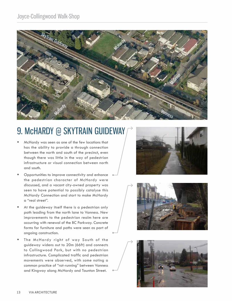
9. McHARDY @ SKYTRAIN GUIDEWAY
SkyTrain Guideway
McHard
y
McHard
y
McGree
r
Vanness
� McHardy was seen as one of the few locations that has the ability to provide a through connection between the north and south of the precinct, even though there was little in the way of pedestrian infrastructure or visual connection between north and south.
� Opportunities to improve connectivity and enhance the pedestrian character of McHardy were discussed, and a vacant city-owned property was seen to have potential to possibly catalyse this McHardy Connection and start to make McHardy a “real street”.
� At the guideway itself there is a pedestrian only path leading from the north lane to Vanness. New improvements to the pedestrian realm here are occurring with renewal of the BC Parkway. Concrete forms for furniture and paths were seen as part of ongoing construction.
� The McHardy r igh t of way Sou th of t he guideway widens out to 20m (66ft) and connects to Collingwood Park, but with no pedestrian infrastructure. Complicated traffic and pedestrian movements were observed, with some noting a common practice of “rat-running” between Vanness and Kingway along McHardy and Taunton Street.
Joyce-Collingwood Walkshop
VIA ARCHITECTURE 14
10. VANNESS @ McHARDYSk
yTrain
Guidew
ay
McGreer
McHardy
Vanness
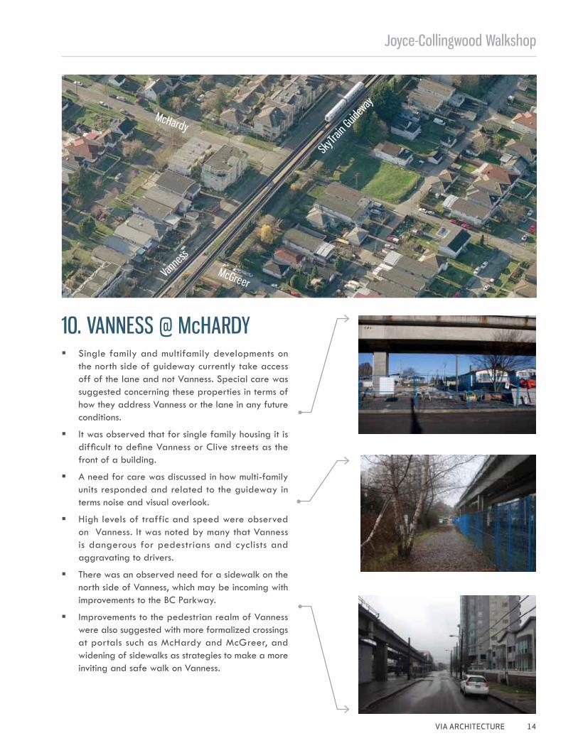
� Single family and multifamily developments on the north side of guideway currently take access off of the lane and not Vanness. Special care was suggested concerning these properties in terms of how they address Vanness or the lane in any future conditions.
� It was observed that for single family housing it is difficult to define Vanness or Clive streets as the front of a building.
� A need for care was discussed in how multi-family units responded and related to the guideway in terms noise and visual overlook.
� High levels of traffic and speed were observed on Vanness. It was noted by many that Vanness is dangerous for pedestrians and cyclists and aggravating to drivers.
� There was an observed need for a sidewalk on the north side of Vanness, which may be incoming with improvements to the BC Parkway.
� Improvements to the pedestrian realm of Vanness were also suggested with more formalized crossings at portals such as McHardy and McGreer, and widening of sidewalks as strategies to make a more inviting and safe walk on Vanness.
Joyce-Collingwood Walk-Shop
15 VIA ARCHITECTURE
11. WEST LANE JOYCE @ VANNESS
SkyTr
ain St
ation
Joyce
Vanness
Clive
West Lane
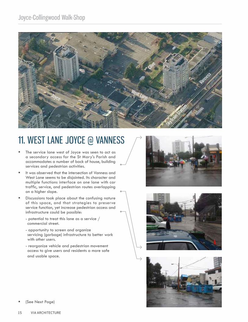
� The service lane west of Joyce was seen to act as a secondary access for the St Mary’s Parish and accommodates a number of back of house, building services and pedestrian activities.
� It was observed that the intersection of Vanness and West Lane seems to be disjointed. Its character and multiple functions interface on one lane with car traffic, service, and pedestrian routes overlapping on a higher slope.
� Discussions took place about the confusing nature of this space, and that strategies to preserve service function, yet increase pedestrian access and infrastructure could be possible:- potential to treat this lane as a service / commercial street.
- opportunity to screen and organize servicing (garbage) infrastructure to better work with other users.
- reorganize vehicle and pedestrian movement access to give users and residents a more safe and usable space.
� (See Next Page)
Joyce-Collingwood Walkshop
VIA ARCHITECTURE 16
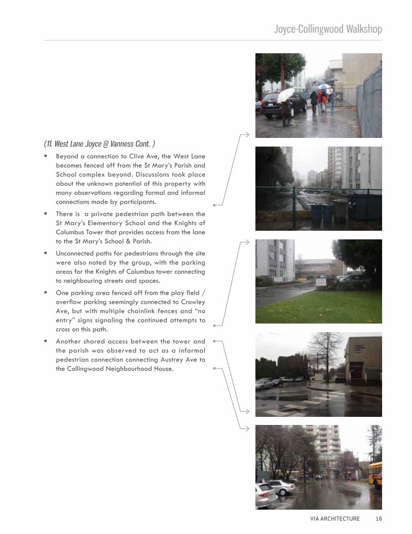
(11. West Lane Joyce @ Vanness Cont. ) � Beyond a connection to Clive Ave, the West Lane
becomes fenced off from the St Mary’s Parish and School complex beyond. Discussions took place about the unknown potential of this property with many observations regarding formal and informal connections made by participants.
� There is a private pedestrian path between the St Mary’s Elementary School and the Knights of Columbus Tower that provides access from the lane to the St Mary’s School & Parish.
� Unconnected paths for pedestrians through the site were also noted by the group, with the parking areas for the Knights of Columbus tower connecting to neighbouring streets and spaces.
� One parking area fenced off from the play field / overflow parking seemingly connected to Crowley Ave, but with multiple chainlink fences and “no entry” signs signaling the continued attempts to cross on this path.
� Another shared access between the tower and the parish was observed to act as a informal pedestrian connection connecting Austrey Ave to the Collingwood Neighbourhood House.
Joyce-Collingwood Walk-Shop
17 VIA ARCHITECTURE
12. VANNESS @ JOYCE
SkyTr
ain St
ation
Joyce
Vanness
West Lane
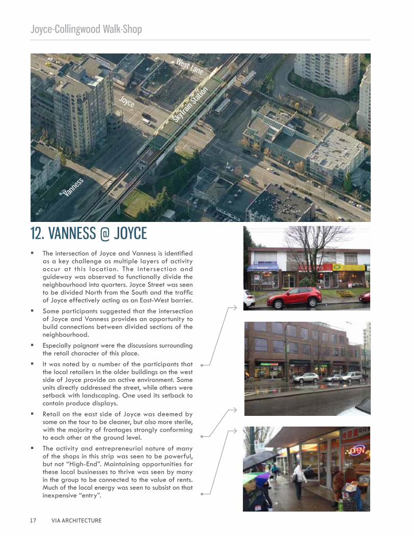
� The intersection of Joyce and Vanness is identified as a key challenge as multiple layers of activity occur at this location. The intersection and guideway was observed to functionally divide the neighbourhood into quarters. Joyce Street was seen to be divided North from the South and the traffic of Joyce effectively acting as an East-West barrier.
� Some participants suggested that the intersection of Joyce and Vanness provides an opportunity to build connections between divided sections of the neighbourhood.
� Especially poignant were the discussions surrounding the retail character of this place.
� It was noted by a number of the participants that the local retailers in the older buildings on the west side of Joyce provide an active environment. Some units directly addressed the street, while others were setback with landscaping. One used its setback to contain produce displays.
� Retail on the east side of Joyce was deemed by some on the tour to be cleaner, but also more sterile, with the majority of frontages strongly conforming to each other at the ground level.
� The activity and entrepreneurial nature of many of the shops in this strip was seen to be powerful, but not “High-End”. Maintaining opportunities for these local businesses to thrive was seen by many in the group to be connected to the value of rents. Much of the local energy was seen to subsist on that inexpensive “entry”.
Joyce-Collingwood Walkshop
VIA ARCHITECTURE 18
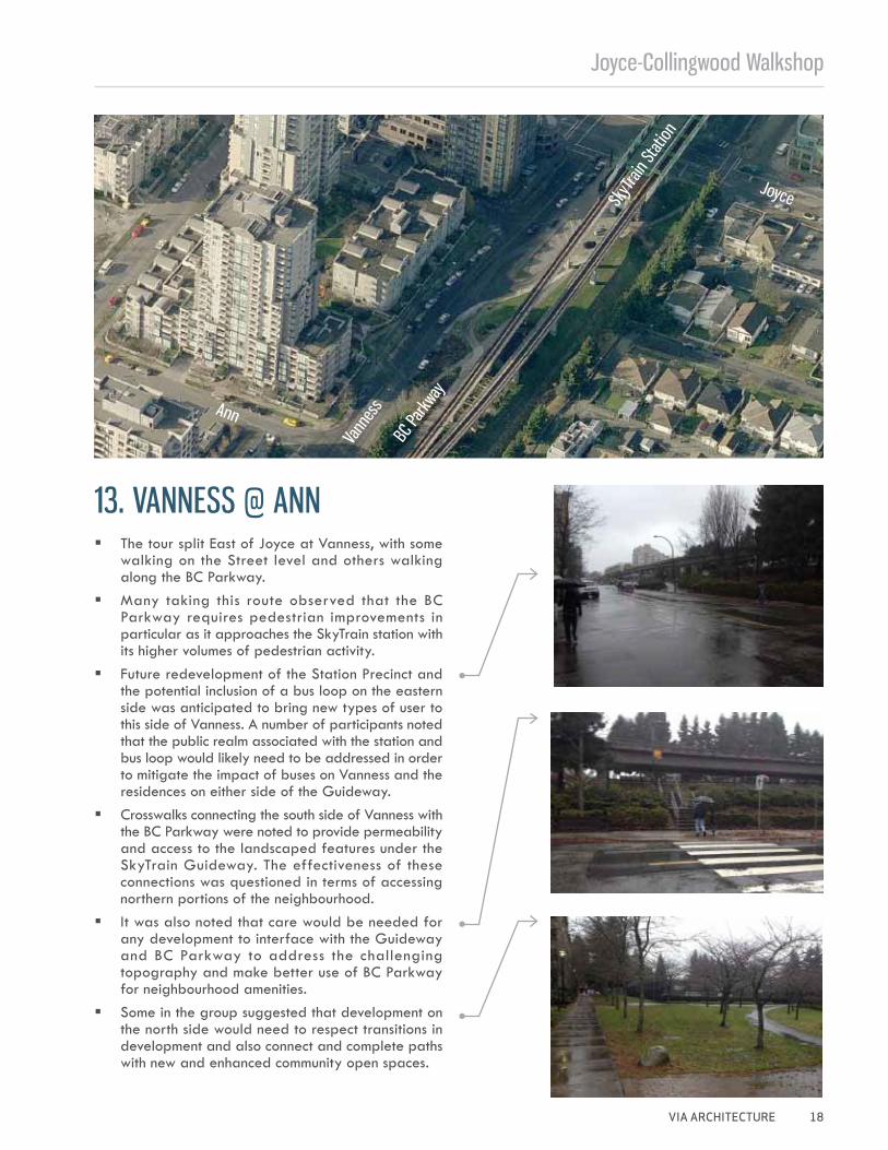
13. VANNESS @ ANN
SkyTr
ain St
ation
Joyce
Ann
Vann
ess
BC Pa
rkway
� The tour split East of Joyce at Vanness, with some walking on the Street level and others walking along the BC Parkway.
� Many taking this route observed that the BC Parkway requires pedestrian improvements in particular as it approaches the SkyTrain station with its higher volumes of pedestrian activity.
� Future redevelopment of the Station Precinct and the potential inclusion of a bus loop on the eastern side was anticipated to bring new types of user to this side of Vanness. A number of participants noted that the public realm associated with the station and bus loop would likely need to be addressed in order to mitigate the impact of buses on Vanness and the residences on either side of the Guideway.
� Crosswalks connecting the south side of Vanness with the BC Parkway were noted to provide permeability and access to the landscaped features under the SkyTrain Guideway. The effectiveness of these connections was questioned in terms of accessing northern portions of the neighbourhood.
� It was also noted that care would be needed for any development to interface with the Guideway and BC Parkway to address the challenging topography and make better use of BC Parkway for neighbourhood amenities.
� Some in the group suggested that development on the north side would need to respect transitions in development and also connect and complete paths with new and enhanced community open spaces.
Joyce-Collingwood Walk-Shop
19 VIA ARCHITECTURE
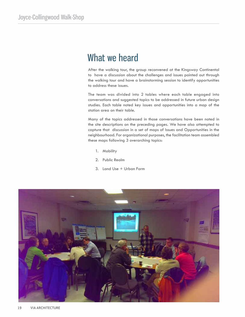
After the walking tour, the group reconvened at the Kingsway Continental to have a discussion about the challenges and issues pointed out through the walking tour and have a brainstorming session to identify opportunities to address these issues.
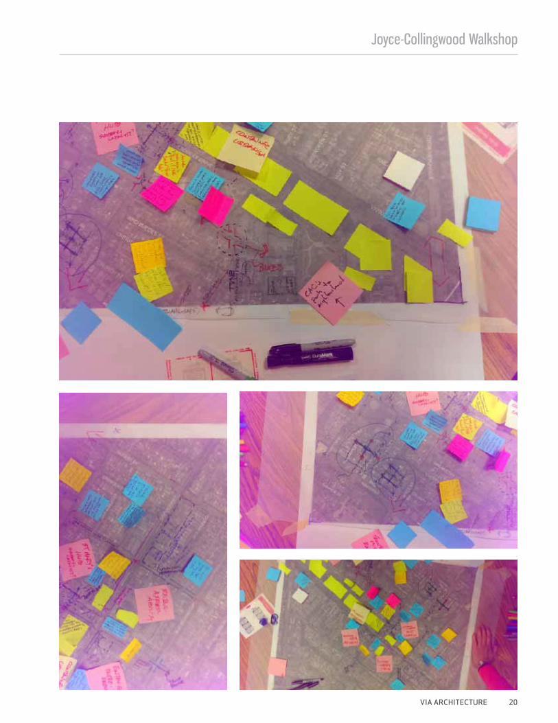
The team was divided into 2 tables where each table engaged into conversations and suggested topics to be addressed in future urban design studies. Each table noted key issues and opportunities into a map of the station area on their table.
Many of the topics addressed in those conversations have been noted in the site descriptions on the preceding pages. We have also attempted to capture that discussion in a set of maps of Issues and Opportunities in the neighbourhood. For organizational purposes, the facilitation team assembled these maps following 3 overarching topics:
1. Mobility
2. Public Realm
3. Land Use + Urban Form
What we heard
Joyce-Collingwood Walkshop
VIA ARCHITECTURE 20
Joyce-Collingwood Walk-Shop
21 VIA ARCHITECTURE
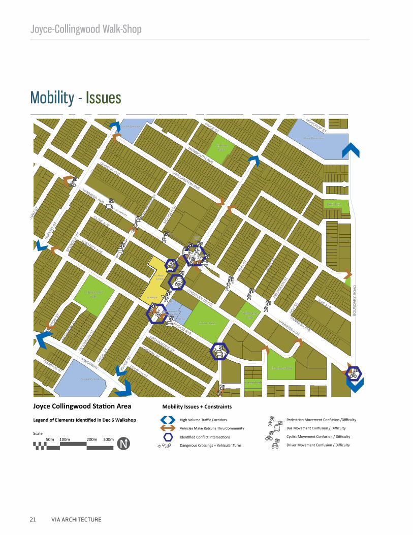
Joyce Collingwood Station Area Mobility Issues + Constraints
Legend of Elements Identified in Dec 6 Walkshop High Volume Traffic Corridors
Vehicles Make Ratruns Thru Community
Pedestrian Movement Confusion /Difficulty
Identified Conflict Intersections
Bus Movement Confusion / Difficulty
Cyclist Movement Confusion / Difficulty
Driver Movement Confusion / DifficultyDangerous Crossings + Vehicular Turns
IVANHOE ST
KINGSWAY
CECI
LSTM
CKIN
NON
ST
MCH
ARDY
ST
JOYC
EST
CHURCH ST
TAUN
TON
ST
CHERRY ST
ARCHIMEDES ST
EUCLID AVE
RUPE
RTST
MST
SPEN
CER
ST
AUSTREY AVE
CROWLEY DRIVE
ROP ST
WELLINGTON AVE
PRICE ST
QUEENS AVE
CLIVE AVE
MCH
ARDY
ST
MCG
GER
ST
ASCOT PLAN
N ST
VANNESS
VANNESS AVE
RUBY
STAB
ERDE
EN ST
HOY
STRAE AVE
MONMOUTH AVE
VANNESS AVE
BO
UN
DA
RY
RO
AD
MOSC
HATH
A
AVE
CollingwoodPark
CollingwoodNeighb. House
School
Carleton Elementary
St. Mary’s
St. Mary’sSchool
Melbourne
Price Park
Park
Gaston Park
Aberdeen Park
Foster Park
Skytrain Station
BC Parkway
CarletonPark
Bruce Elementary
Grenfell Elementary
CNIBYMCA
Scale50m 100m 200m 300m
Mobility - Issues
Joyce-Collingwood Walkshop
VIA ARCHITECTURE 22
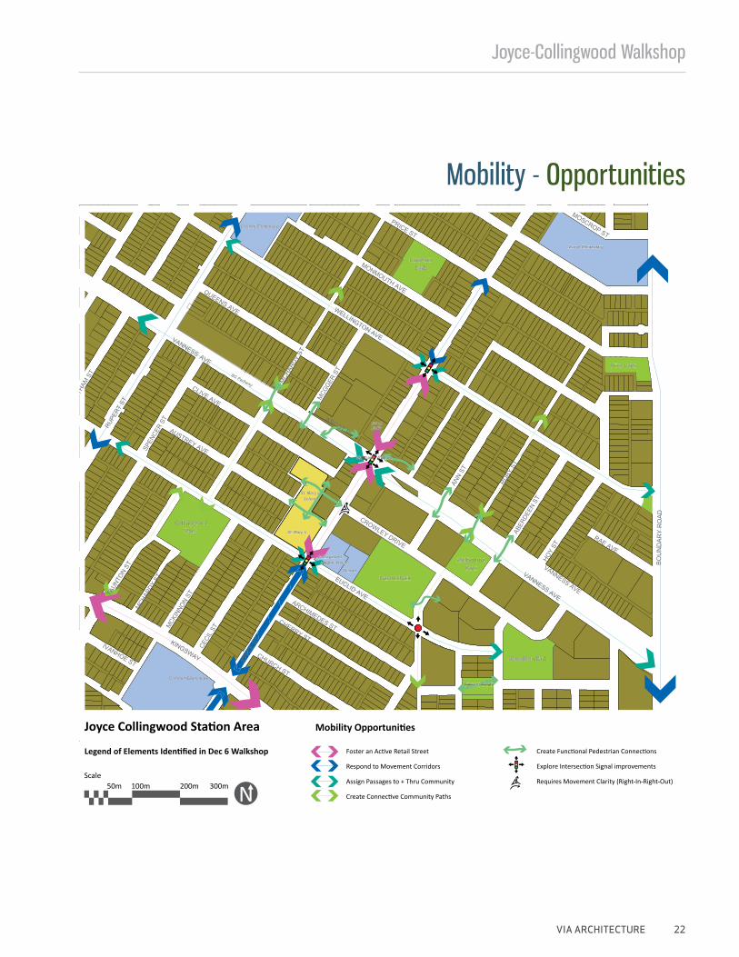
Joyce Collingwood Station Area Mobility Opportunities
Legend of Elements Identified in Dec 6 Walkshop Foster an Active Retail Street
Respond to Movement Corridors
Assign Passages to + Thru Community
Create Connective Community Paths
Create Functional Pedestrian Connections
Explore Intersection Signal improvements
Requires Movement Clarity (Right-In-Right-Out)
IVANHOE ST
KINGSWAY
CECI
LSTM
CKIN
NON
ST
MCH
ARDY
ST
JOYC
EST
CHURCH ST
TAUN
TON
ST
CHERRY ST
ARCHIMEDES ST
EUCLID AVE
RUPE
RTST
MST
SPEN
CER
ST
AUSTREY AVE
CROWLEY DRIVE
ROP ST
WELLINGTON AVE
PRICE ST
QUEENS AVE
CLIVE AVE
MCH
ARDY
ST
MCG
GER
ST
ASCOT PL
ANN
ST
VANNESS
VANNESS AVE
RUBY
STAB
ERDE
EN ST
HOY
ST
RAE AVE
MONMOUTH AVE
VANNESS AVE
BO
UN
DA
RY
RO
AD
MOSC
HATH
A
AVE
CollingwoodPark
CollingwoodNeighb. House
School
Carleton Elementary
St. Mary’s
St. Mary’sSchool
Melbourne
Price Park
Park
Gaston Park
Aberdeen Park
Foster Park
Skytrain Station
BC Parkway
CarletonPark
Bruce Elementary
Grenfell Elementary
CNIBYMCA
Scale50m 100m 200m 300m
Mobility - Opportunities
Joyce-Collingwood Walk-Shop
23 VIA ARCHITECTURE
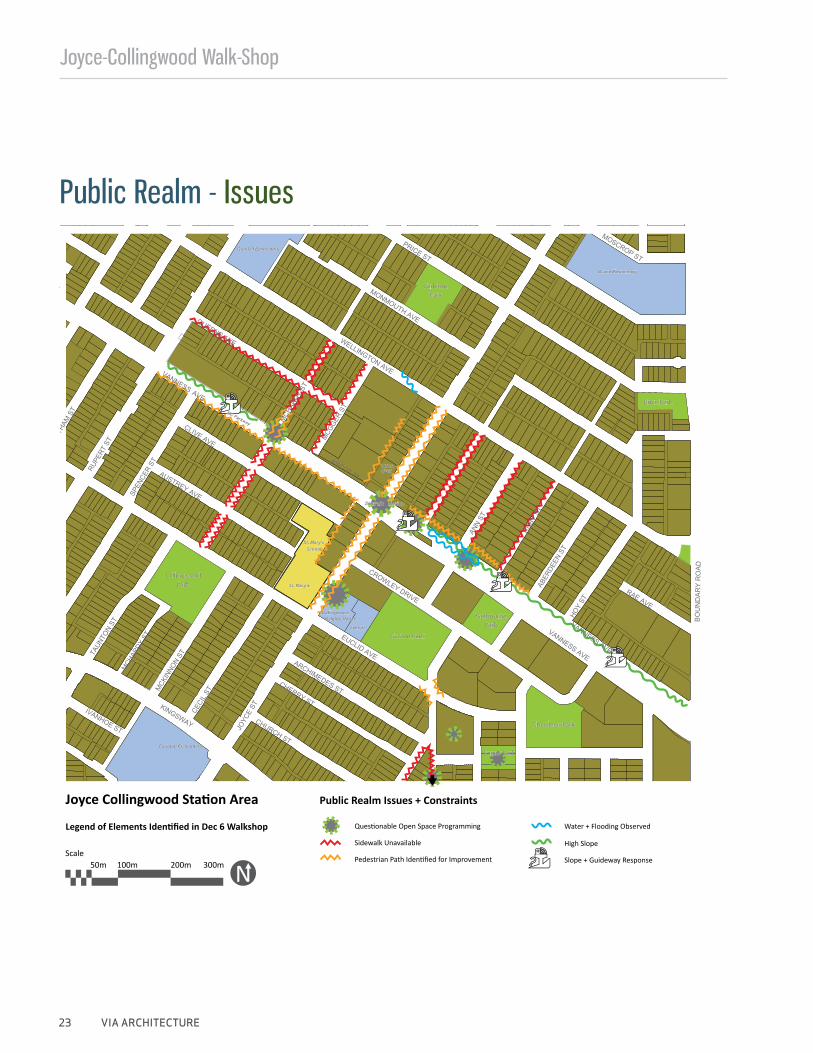
Joyce Collingwood Station Area Public Realm Issues + Constraints
Legend of Elements Identified in Dec 6 WalkshopSidewalk Unavailable
Questionable Open Space Programming
Pedestrian Path Identified for Improvement
High Slope
Slope + Guideway Response
Water + Flooding Observed
IVANHOE ST
KINGSWAY
CECI
LSTM
CKIN
NON
ST
MCH
ARDY
ST
JOYC
EST
CHURCH ST
TAUN
TON
ST
CHERRY ST
ARCHIMEDES ST
EUCLID AVE
RUPE
RTST
MST
SPEN
CER
ST
AUSTREY AVE
CROWLEY DRIVE
ROP ST
WELLINGTON AVE
PRICE ST
QUEENS AVE
CLIVE AVE
MCH
ARDY
ST
MCG
GER
ST
ASCOT PLAN
N ST
VANNESS
VANNESS AVE
RUBY
STAB
ERDE
EN ST
HOY
STRAE AVE
MONMOUTH AVE
VANNESS AVE
BO
UN
DA
RY
RO
AD
MOSC
HATH
A
AVE
CollingwoodPark
CollingwoodNeighb. House
School
Carleton Elementary
St. Mary’s
St. Mary’sSchool
Melbourne
Price Park
Park
Gaston Park
Aberdeen Park
Foster Park
Skytrain Station
BC Parkway
CarletonPark
Bruce Elementary
Grenfell Elementary
CNIBYMCA
Scale50m 100m 200m 300m
Public Realm - Issues
Joyce-Collingwood Walkshop
VIA ARCHITECTURE 24
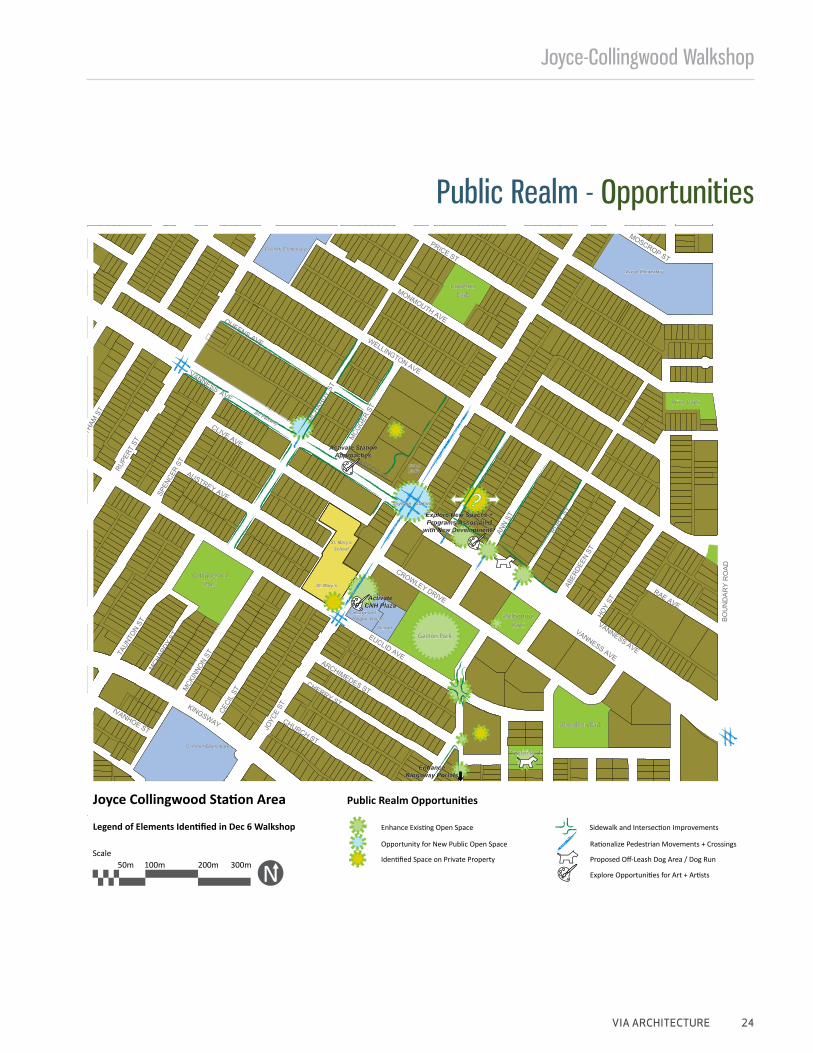
Explore New Spaces + Programs Associated
with New Development?
Activate CNH Plaza
Activate Station Approaches
Enhance Kingsway Portals
Joyce Collingwood Station Area Public Realm Opportunities
Legend of Elements Identified in Dec 6 Walkshop
Opportunity for New Public Open Space
Enhance Existing Open Space Sidewalk and Intersection Improvements
Rationalize Pedestrian Movements + Crossings
Proposed Off-Leash Dog Area / Dog Run
Explore Opportunities for Art + Artists
Identified Space on Private Property
IVANHOE ST
KINGSWAY
CECI
LSTM
CKIN
NON
ST
MCH
ARDY
ST
JOYC
EST
CHURCH ST
TAUN
TON
ST
CHERRY ST
ARCHIMEDES ST
EUCLID AVE
RUPE
RTST
MST
SPEN
CER
ST
AUSTREY AVE
CROWLEY DRIVE
ROP ST
WELLINGTON AVE
PRICE ST
QUEENS AVE
CLIVE AVE
MCH
ARDY
ST
MCG
GER
ST
ASCOT PL
ANN
ST
VANNESS
VANNESS AVE
RUBY
STAB
ERDE
EN ST
HOY
ST
RAE AVE
MONMOUTH AVE
VANNESS AVE
BO
UN
DA
RY
RO
AD
MOSC
HATH
A
AVE
CollingwoodPark
CollingwoodNeighb. House
School
Carleton Elementary
St. Mary’s
St. Mary’sSchool
Melbourne
Price Park
Park
Gaston Park
Aberdeen Park
Foster Park
Skytrain Station
BC Parkway
CarletonPark
Bruce Elementary
Grenfell Elementary
CNIBYMCA
Scale50m 100m 200m 300m
Public Realm - Opportunities
Joyce-Collingwood Walk-Shop
25 VIA ARCHITECTURE
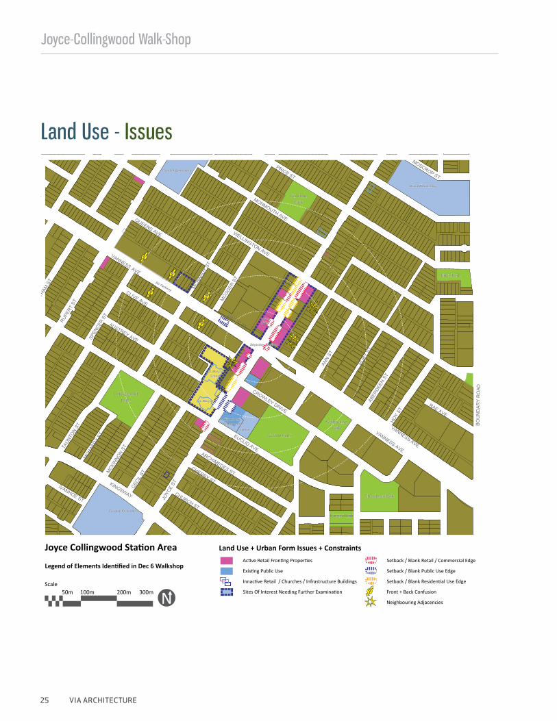
Joyce Collingwood Station Area Land Use + Urban Form Issues + Constraints
Legend of Elements Identified in Dec 6 WalkshopActive Retail Fronting Properties
Existing Public Use
Innactive Retail / Churches / Infrastructure Buildings
Sites Of Interest Needing Further Examination
Setback / Blank Retail / Commercial Edge
Setback / Blank Public Use Edge
Setback / Blank Residential Use Edge
Front + Back Confusion
Neighbouring Adjacencies
IVANHOE ST
KINGSWAY
CECI
LSTM
CKIN
NON
ST
MCH
ARDY
ST
JOYC
EST
CHURCH ST
TAUN
TON
ST
CHERRY ST
ARCHIMEDES ST
EUCLID AVE
RUPE
RTST
MST
SPEN
CER
ST
AUSTREY AVE
CROWLEY DRIVE
ROP ST
WELLINGTON AVE
PRICE ST
QUEENS AVE
CLIVE AVE
MCH
ARDY
ST
MCG
GER
ST
ASCOT PLAN
N ST
VANNESS
VANNESS AVE
RUBY
STAB
ERDE
EN ST
HOY
STRAE AVE
MONMOUTH AVE
VANNESS AVE
BO
UN
DA
RY
RO
AD
MOSC
HATH
A
AVE
CollingwoodPark
CollingwoodNeighb. House
School
Carleton Elementary
St. Mary’s
St. Mary’sSchool
Melbourne
Price Park
Park
Gaston Park
Aberdeen Park
Foster Park
Skytrain Station
BC Parkway
CarletonPark
Bruce Elementary
Grenfell Elementary
CNIBYMCA
Scale50m 100m 200m 300m
Land Use - Issues
Joyce-Collingwood Walkshop
VIA ARCHITECTURE 26
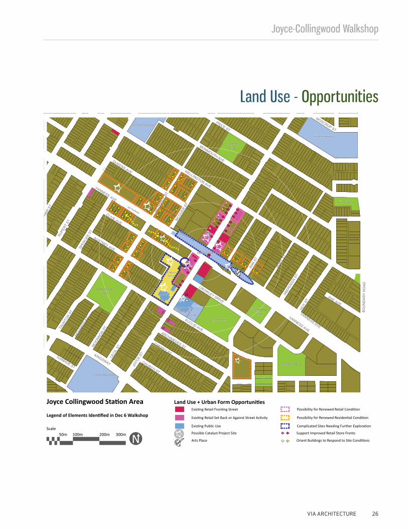
Joyce Collingwood Station Area Land Use + Urban Form Opportunities
Legend of Elements Identified in Dec 6 Walkshop
Possible Catalyst Project Site
Existing Retail Fronting Street
Existing Retail Set Back or Against Street Activity
Existing Public Use
Arts Place
Complicated Sites Needing Further Exploration
Support Improved Retail Store Fronts
Orient Buildings to Respond to Site Conditions
Possibility for Renewed Retail Condition
Possibility for Renewed Residential Condition
IVANHOE ST
KINGSWAY
CECI
LSTM
CKIN
NON
ST
MCH
ARDY
ST
JOYC
EST
CHURCH ST
TAUN
TON
ST
CHERRY ST
ARCHIMEDES ST
EUCLID AVE
RUPE
RTST
MST
SPEN
CER
ST
AUSTREY AVE
CROWLEY DRIVE
ROP ST
WELLINGTON AVE
PRICE ST
QUEENS AVE
CLIVE AVE
MCH
ARDY
ST
MCG
GER
ST
ASCOT PL
ANN
ST
VANNESS
VANNESS AVE
RUBY
STAB
ERDE
EN ST
HOY
ST
RAE AVE
MONMOUTH AVE
VANNESS AVE
BO
UN
DA
RY
RO
AD
MOSC
HATH
A
AVE
CollingwoodPark
CollingwoodNeighb. House
School
Carleton Elementary
St. Mary’s
St. Mary’sSchool
Melbourne
Price Park
Park
Gaston Park
Aberdeen Park
Foster Park
Skytrain Station
BC Parkway
CarletonPark
Bruce Elementary
Grenfell Elementary
CNIBYMCA
Scale50m 100m 200m 300m
Land Use - Opportunities