Embed Size (px)
Citation preview
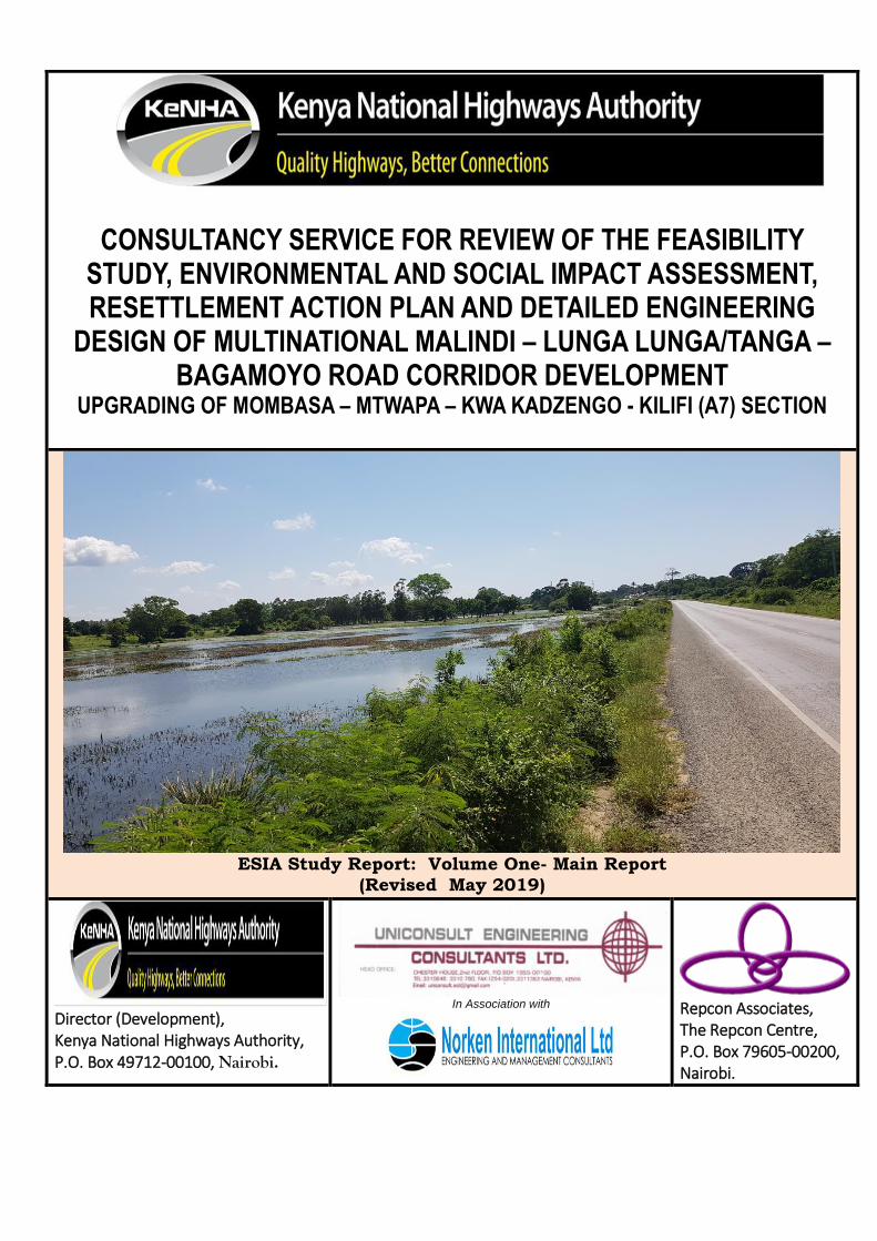
CONSULTANCY SERVICE FOR REVIEW OF THE FEASIBILITY STUDY, ENVIRONMENTAL AND SOCIAL IMPACT ASSESSMENT, RESETTLEMENT ACTION PLAN AND DETAILED ENGINEERING
DESIGN OF MULTINATIONAL MALINDI – LUNGA LUNGA/TANGA – BAGAMOYO ROAD CORRIDOR DEVELOPMENT
UPGRADING OF MOMBASA – MTWAPA – KWA KADZENGO - KILIFI (A7) SECTION
ESIA Study Report: Volume One- Main Report
(Revised May 2019)
Director (Development), Kenya National Highways Authority, P.O. Box 49712-00100, Nairobi.
In Association with
Repcon Associates, The Repcon Centre, P.O. Box 79605-00200, Nairobi.
EXECUTIVE SUMMARY
THE PROJECT The Government of the Republic of Kenya, through its implementing agency, the Kenya National Highways Authority (KeNHA) and support of the African Development Bank (AfDB) is upgrading the Mombasa – Mtwapa – Kwa Kadzengo - Kilifi Section of the Multinational A7 Highway. Towards this, KENHA has commissioned a Consultancy Study to Review the Feasibility Study, Environmental and Social Impact Assessment, Resettlement Action Plan and Detailed Engineering developed under auspices of the wider Multinational Malindi –Lunga Lunga/Tanga–Bagamoyo Road Corridor Development.
As part of the contract, and in line with existing national legislation and international practice, the project was subjected to environmental and social screening based on local and international best practices for environmental management. Specifically, the Consultant undertook the review of the Environmental and Social Impact Assessment (ESIA) Report previously prepared for the Multinational Malindi–Lunga Lunga/Tanga – Bagamoyo Road Corridor Development Project with a view to customising an ESMP for the target road section. This Report highlights salient social and environmental issues associated with the design, construction and operational aspects of the Project and has been prepared under contract by Lead Experts from Repcon Associates, an Environmental Firm of Experts duly registered and licensed by NEMA (NEMA Registration No. 0002) and other Government of Kenya (GoK) Agencies.
SCOPE OF THE ESIA STUDY
The ESIA Study covers the alignment of the proposed road in Mombasa and Kilifi counties details of which are outlined in Chapter two below. Detailed scope of the ESIA is captured in the TORs for the Broader Study as follows:-
1. Detailed engineering design through all necessary data collection, field surveys and analysis to cover all aspects of detailed design; including consideration of alternative routes and pavement options, road safety and land acquisition,
2. Environmental and Social Impact Assessment (ESIA) in accordance with Kenyan legislation, NEMA guidelines; and AfDB guidelines for Integrated Social Safeguards (ISS).
3. RAP Report to be in line with the current status of the road to ensure all issues regarding ROW are addressed. Prepare a full Resettlement Action Plan (RAP) and associated surveys to identify and value of property that will be affected by the road upgrading works along the road reserve
4. Carrying out of gender analysis in relation to the proposed project as outlined in the detailed Terms of Reference.
5. Design of geometrics and pavement and all other aspects of the design in accordance with the applicable Kenyan Road Design Manuals and current international engineering practices
This report is in respect of TOR Item No 2 above.

Kenya National Highway
Authority-KENHA
Supplementary ESIA Report in the Consultancy Service for Review of the Feasibility Study, Environmental and Social Impact Assessment, Resettlement Action Plan and Detailed Engineering Design of Multinational Malindi – Lunga Lunga/Tanga–Bagamoyo Road Corridor Development: Upgrading of Mombasa– Mtwapa – Kwa Kadzengo -Kilifi (A7) Section
2019
ii
STUDY METHODOLOGY
The ESIA Report previously prepared for Multinational Malindi – Lunga Lunga Road was reviewed against set standards namely:-
Kenyan Standards: EMC(A) 2015 and LN 101 of 2003 (of EMCA); other Kenyan legislation.
AfDB Standards: Operational Safeguards for Integrated Social Safeguards (ISS).
Other standards (World Bank)
Upon review of the existing ESIA Report, a full Supplementary ESIA Study was mounted to bridge all existing gaps. The decision to mount full supplementary ESIA Study was informed by findings that:-
The EIA License previously issued for the Multinational Malindi – Lunga Lunga Road had lapsed and hence required to be updated.
As well, and from the gap analysis undertaken for the Malindi-Lunga Lunga ESIA process, it emerges that the ESIA Process, ESMP and attendant EIA Licence cannot adequately secure sustainable environmental and social management for the proposed dualling of the Mombasa-Mtwapa-Kadzengo Section and upgrading of Kwa Kadzengo - Kilifi Section including the proposed Second Mtwapa Bridge.
Other reasons that would warrant a full cycle study include the following:-
Culturally sensitive sites: The section of the A7 highway targeted for upgrading traverses several sites of cultural interest including the Kisauni Bell Tower (Kengeleni Tower) gazetted as a National Monument by the NMK since 1983, the Frere Town Community Church among others which required clear mapping for preservation as part of the ESIA process.
Ecologically Sensitive sites: Sites that will require focused attention during an ESIA process include Bamburi Forest Block and its Haller Park, the Mtwapa Creek Ecosystem, seasonal lakes (marshlands) such as Kwa Kadzengo, water courses such as Mtopanga among others. The Kwa Kadzengo marshland is habitat for 5 AEWA Bird Species.
Drainage challenges: On account of a largely flat, sometimes internally draining topography, the entire A7 highway section between Kongowea and Mtwapa Bridge suffers a huge drainage problem which spills over into sections of the Nyali Estate.
The Question of economic displacement: The A7 Road between Mombasa and Mtwapa is an Economic Corridor. There are many citizens deriving livelihoods through trading in the reserve of the A7 Highway and their potential displacement in road upgrading is currently a major concern. As well, Mtwapa is a residential town which houses labour for Mombasa

Kenya National Highway
Authority-KENHA
Supplementary ESIA Report in the Consultancy Service for Review of the Feasibility Study, Environmental and Social Impact Assessment, Resettlement Action Plan and Detailed Engineering Design of Multinational Malindi – Lunga Lunga/Tanga–Bagamoyo Road Corridor Development: Upgrading of Mombasa– Mtwapa – Kwa Kadzengo -Kilifi (A7) Section
2019
iii
Town and the latter is transported through the A7 Road. Any disruption in passenger transport is likely to cause economic shocks in Mombasa.
Given these considerations, a study process culminating in a Supplementary ESIA Study Report was conceived and implemented in Line with Cap 387 and its tools.
FINDINGS OF THE STUDY
Ecological Sensitivity: A total of 81 bird species were recorded in diverse habitats traversed with the highest count of 41 birds being recorded around the Kwa Kadzengo marshlands.
Conservation status: A total of 81-bird species were counted within the traverse area. All the 81 avian species recorded were screened for conservation status against the IUCN RED LIST data and AEWA checklist with outcome that 8 birds are of concern in that three species namely;- the Gray Parrot, Fisher’s Lovebird and Wooly necked Stork feature in the IUCN RED LIST Data on account of being Endangered, Near Threatened and Vulnerable while 5 species namely;- the Zanzibar Somber Greenbul, Cattle Egret, Grey Heron, Sacred Ibis and the Three-banded Plover are listed in the AEWA (Agreement on the Conservation of African-Eurasian Migratory Water Birds). All the AEWA species are found in the seasonal Kwa Kadzengo marshland (WL) habitat which makes this marsh and surrounding farmland very important habitat for migratory water birds.
IMPACT PREDICTION: Based on impact prediction and scoping tools, potential impacts from proposed road upgrading and operation have been predicted and analysed with outcome as tabulated below followed by brief highlights.
Positive impacts: Positive impacts of the road will accrue from provision of an expanded functional road linkage, linking Kenya’s North Coast to Mombasa. Further, provision of grade separated interchanges will smoothen traffic flow, eliminate snarl ups and thus drastically cut down on time wasted in the transport of both goods and passengers.
Essentially, the new road will decongest Kongowea, Bombululu and Mtwapa Centres thus making it comfortable for local inhabitants including traders.
Adverse impacts: The most salient observation from this study is that, expansion of the Mombasa-Mtwapa-Kadzengo-Kilifi (A7) Section to about 37metre wide corridor will entail land acquisition in some places and in the process, will displace some people from land, property, business premises and shelter.

Kenya National Highway
Authority-KENHA
Supplementary ESIA Report in the Consultancy Service for Review of the Feasibility Study, Environmental and Social Impact Assessment, Resettlement Action Plan and Detailed Engineering Design of Multinational Malindi – Lunga Lunga/Tanga–Bagamoyo Road Corridor Development: Upgrading of Mombasa– Mtwapa – Kwa Kadzengo -Kilifi (A7) Section
2019
iv
Once completed, the road will create a physical barrier to movement and access within the traverse.
THE ENVIRONMENTAL AND SOCIAL MANAGEMENT PLAN (ESMP) The core outcome of the ESIA Study is an ESMP developed to guide resolution of adverse impacts occasioned by development of the road project. The ESMP comprises four core elements namely: - the Impact Mitigation Plan, the Monitoring Plan, a budget for implementation and modalities for institutional coordination and role play.
The core mitigation strategy in the project was to review and adopt a route alignment that served to avoid, reduce and manage environmental and social concerns as follows:-
Restriction of expansion of the Mombasa-Mtwapa-Kadzengo road section to about 37m wide corridor down from the 60m proposed earlier on. This single move has cut down land acquisition from 56.16 to 19 hectares with the tally of potentially displaced PAPs dropping from 3566 to 1894; equivalent to 53.1% of original displacement (See comparative analysis below).
Comparative analysis of displacement from the 60 and 37m wide corridor options
Parcels Hectares Structures PAPs Parcels Hectares Structures PAPs
Mombasa 13.5 364 42.56 301 2533 255 15.2 295 1531
Kilifi 42.6 211 11.6 209 1033 123 3.8 93 363
Totals 56.1 575 54.16 510 3566 378 19 388 1894
% of original 65.7 35.1 76.1 53.1
Displacement by at 37m wide ROWCounty Road length
(Km)
Potential displacement by a 60m ROW
Restriction of development of the Kadzengo - Kilifi Section to within the existing road reserve thereby completely eliminating displacement and attendant land acquisition.
Selection of a design option that will preserve the Kengeleni Tower and Frere Community Church both of which are physical cultural assets.
To the largest extent possible, the strategy and action plan in formulating the ESMP is to prevent impact occurrence, then move to mitigate inevitable occurrence-a position secured by ensuring that recommendations made here-in are incorporated into and influence final outcome of the project design process in which case, the latter process also becomes part of the mitigation programme. In pursuit of this strategy, all mitigation will adopt measures as follows:-
The Environmental and Social Management Plan unveiled in Chapter Twelve below will be integrated - as a stand-alone
Kenya National Highway
Authority-KENHA
Supplementary ESIA Report in the Consultancy Service for Review of the Feasibility Study, Environmental and Social Impact Assessment, Resettlement Action Plan and Detailed Engineering Design of Multinational Malindi – Lunga Lunga/Tanga–Bagamoyo Road Corridor Development: Upgrading of Mombasa– Mtwapa – Kwa Kadzengo -Kilifi (A7) Section
2019
v
The same will be provided for in the BOQs to ensure funding allocation for environmental and social mitigation
Clauses binding parties to affirmative action on the ESMP will be integrated into Contracts for Construction to ensure that the contractor is legally bound to implement impact mitigation.
The burden of mitigation largely lies with the Project Contractor under supervision by KeNHA through the Supervising Consultant. Key observations are that most adverse impacts are short-term and will disappear once civil works ends while residual impacts will require careful monitoring and coordination with relevant Lead Agencies. A sum of Kshs 3,312,742,369 will be required in environmental and social mitigation of which, 97.9% will go to land acquisition with the rest being available to the Contractor for purposes of environmental restitution. The core monitoring strategy for this project will be through site meetings during construction stage, in which case, it is recommended that respective County Environmental Coordinators for Mombasa and Kilifi be invited to such meetings. Other stakeholders such as the County Labour Officer should also initially attend such meetings to ascertain that measures towards securing the health and safety of workers have been put in place. When completed, the Road Project will be subject to statutory environmental and quality audits during the Defect Liability Period and the Contractor will be liable to repair all defects including those pertaining to environmental mitigation.
Overall, it is the impression of this study that, the proposed road upgrading project is a vital economic undertaking to which national and regional development targets are tied. It is a vital transport artery and, subject to adoption of mitigation measures and proposals made here-in, it should be supported by all.
RECOMMENDATION Through this Supplementary ESIA Study Report, the Kenya National Highway Authority (KeNHA) through the Director General - the proponent - wishes to disclose that the proposed upgrading of the Mombasa-Mtwapa-Kadzengo - Kilifi Section of the A7 Road has impacts that can readily be mitigated and managed. The majority of adverse impacts identified are of a short-term nature and will cease once the civil works phase is completed. Further, other impacts can be contained through effective planning and management using available means of mitigation. By such disclosure, the prayer of the client to NEMA is for the project to be granted environmental licensing.

Kenya National Highway
Authority-KENHA
Supplementary ESIA Report in the Consultancy Service for Review of the Feasibility Study, Environmental and Social Impact Assessment, Resettlement Action Plan and Detailed Engineering Design of Multinational Malindi – Lunga Lunga/Tanga–Bagamoyo Road Corridor Development: Upgrading of Mombasa– Mtwapa – Kwa Kadzengo -Kilifi (A7) Section
2019
vi
ACRONYMS
AEWA - African Eurasian Water Bird Agreement AfDB - African Development Bank AIDS - Acquired Immuno-Deficiency Syndrome Asl - Above sea level BOQs - Bill of Quantities BRT - Bus Rapid Transit Cap - Chapter of the laws of Kenya CBD - Central Business District CDA - Coastal Development Authority CIDP - City Integrated Development Plan CITES - The Convention on Trade in Endangered Species CMS - Convention on the Conservation of Migratory Species of
Wild animals DG - Director General EIA - Environmental Impacts Assessment EMCA - Environmental Management & Coordination Act ESIA - Environmental and Social Impact Assessment ESMP - Environmental and Social Management Plan g-C m-2 yr-1 - Grams Carbon per square metre per year GDP - Growth Domestic Product GHG - Green House Gas GoK - Government of Kenya GPS - Global Position System HIV - Human Immuno-Virus IMP - Impact mitigation Plan ISS - Integrated Social Safeguards IUCN - International Union for the Conservation of Nature KALRO - Kenya Agriculture and Livestock Research Organisation KNBS - Kenya National Bureau of Statistics KeNHA - Kenya National Highways Authority KeRRA - Kenya Rural Roads Authority KFS - Kenya Forest Service KURA - Kenya Urban Roads Authority LN - Legal Notice m, m2, m3 Metre, square metre, cubic metre MCA - Member of County Assembly MDGs - Millennium Development Goals MOU - Memorandum of Understanding MTP - Medium Term Plan NEMA - National Environment Management Authority NEAP - National Environment Action Plan NMK - National Museum of Kenya NPEP - National Povert Eradiction Plan OHS - Occupational Health and Safety

Kenya National Highway
Authority-KENHA
Supplementary ESIA Report in the Consultancy Service for Review of the Feasibility Study, Environmental and Social Impact Assessment, Resettlement Action Plan and Detailed Engineering Design of Multinational Malindi – Lunga Lunga/Tanga–Bagamoyo Road Corridor Development: Upgrading of Mombasa– Mtwapa – Kwa Kadzengo -Kilifi (A7) Section
2019
vii
OSHA - Occupational Safety and Health Act OSS - Operational Safety Safeguards PCU - Project Coordination Unit PE - Project Engineer PET - Potential evapo-transpiration ppm Parts per million PRSP - Poverty Reduction Strategy Paper RAP - Resettlement Action Plan RE - Resident Engineer ROW - Right of Way SOW - Supervisor of Works STDs - Sexually Transmitted Diseases TOR - Terms of Reference UNCED - United Nations Conference on Environment and
Development UNEP - United Nations Environment Programme UNFCCC - United Nations Framework Convention on Climate Change USAID/REDSO/ WCA – Abidjan
- United States Agency for International Aid / Regional Development Services Office / West and Central Africa
WL - Wetland WMCA - Wildlife Management and Conservation Act WRMA - Water Resources Management Authority WSSD - World Summit of Social Development µg nano gram (unit of measure)

Kenya National Highway
Authority-KENHA
Supplementary ESIA Report in the Consultancy Service for Review of the Feasibility Study, Environmental and Social Impact Assessment, Resettlement Action Plan and Detailed Engineering Design of Multinational Malindi – Lunga Lunga/Tanga–Bagamoyo Road Corridor Development: Upgrading of Mombasa– Mtwapa – Kwa Kadzengo -Kilifi (A7) Section
2019
viii
TABLE OF CONTENTS
EXECUTIVE SUMMARY ................................................................................... i
EXECUTIVE SUMMARY ................................................................................... i
THE PROJECT ..................................................................................................... i
SCOPE OF THE ESIA STUDY .......................................................................... i
STUDY METHODOLOGY ................................................................................. ii
RECOMMENDATION ......................................................................................... v
ACRONYMS ....................................................................................................... vi
TABLE OF CONTENTS .................................................................................. viii
CHAPTER ONE: INTRODUCTION ....................................................................................... xii
BACKGROUND .................................................................................................. 1
SCOPE OF THE ESIA STUDY .......................................................................... 1
1.2.1: Geographical Scope .................................................................... 1
1.2.2: Thematic Scope of the Study ...................................................... 1
STUDY METHODOLOGY ................................................................................ 2
1.3.1: Requirements of the TORs .......................................................... 2
1.3.2: Systematic Review Procedure .................................................... 2
1.3.3: Outcome Screening against Kenya Standards .......................... 2
1.3.4: Outcome Screening against AfDB Integrated Social Safeguards (ISS) ....................................................................................................... 5
1.3.5: Recommended way-forward with the ESIA Process .................. 6
1.3.6: Scale of ESIA Study conceived and designed ........................... 6
1.4: Procedure for Full Cycle ESIA Study ............................................. 8
1.4.1: Data collection procedure ........................................................... 8
1.4.2: Field Work and Public Consultations ......................................... 8
1.4.3: Data Analysis and Impact Prediction ......................................... 8
1.4.4: Identification of Mitigation Measures ......................................... 9
1.4.5: Identification of Monitoring Requirements................................. 9
THE ESIA TEAM ................................................................................................ 9
PRESENTATION OF THE REPORT ............................................................... 9
CHAPTER TWO: PROJECT DESCRIPTION .................................................................. 11
2.1: OWNERSHIP .......................................................................................... 11
2.2: PROJECT SCOPE .................................................................................. 11
2.2.1: Project Components ............................................................... 11

Kenya National Highway
Authority-KENHA
Supplementary ESIA Report in the Consultancy Service for Review of the Feasibility Study, Environmental and Social Impact Assessment, Resettlement Action Plan and Detailed Engineering Design of Multinational Malindi – Lunga Lunga/Tanga–Bagamoyo Road Corridor Development: Upgrading of Mombasa– Mtwapa – Kwa Kadzengo -Kilifi (A7) Section
2019
ix
2.2.3: Dimensions of the Project ......................................................... 12
2.2.4: Structures in the Project ........................................................... 14
2.3: ACTIVITIES IN PROJECT IMPLEMENTATION ............................... 15
2.4: ACTIVITIES DURING OPERATION AND DECOMMISSIONING .. 16
2.5: PROJECT JUSTIFICATION.................................................................... 17
2.6: TOTAL COST OF THE PROJECT ......................................................... 17
CHAPTER THREE: POLICY, LEGAL AND ADMINISTRATIVE FRAMEWORK ........ 18
3.1: THE POLICY FRAMEWORK ................................................................. 18
3.1.1: The GOK Policy Framework ...................................................... 18
3.1.2: Operational Standards of the African Development Bank ........ 24
3.2: LEGAL REGULATORY FRAMEWORK FOR ENVIRONMENTAL MANAGEMENT IN KENYA ............................................................................ 26
3.2.1: Constitutional Provisions ......................................................... 26
3.2.2: The Environmental management and Coordination Act (Cap 287) ...................................................................................................... 27
3.2.3: Inter-Sectoral Coordination in Environmental Protection ....... 29
3.2.4: Codes, Specifications and Standards ...................................... 39
3.2.5: National legal provisions on gender equity and mainstreaming ............................................................................................................. 42
3.2.6: International Conventions, Treaties and Agreements ............. 46
3.3: THE INSTITUTIONAL FRAMEWORK ................................................ 47
3.3.1: Institutional framework under Cap 387 .................................... 47
3.3.2: The Kenya National Highways Authority-KeNHA ..................... 48
CHAPTER FOUR: THE BASELINE ENVIRONMENT ...................................................... 49
4.1: APPROACH TO BASELINE CHARACTERIZATION ........................ 49
4.2: THE PHYSICAL PROFILE ............................................................... 49
4.2.1: Relief and physiographic profile ............................................ 49
4.2.2: Geology and Soils ................................................................... 50
4.2.3: Drainage and Hydrology ......................................................... 50
4.3: CLIMATE AND AGRO-CLIMATOLOGY ............................................ 51
4.3.1: Sources of Climatic Data........................................................... 51
4.3.2: Seasonal Patterns in Temperature, Wind Run, Relative Humidity and Sunshine ...................................................................... 53
4.3.3: Rainfall ....................................................................................... 55

Kenya National Highway
Authority-KENHA
Supplementary ESIA Report in the Consultancy Service for Review of the Feasibility Study, Environmental and Social Impact Assessment, Resettlement Action Plan and Detailed Engineering Design of Multinational Malindi – Lunga Lunga/Tanga–Bagamoyo Road Corridor Development: Upgrading of Mombasa– Mtwapa – Kwa Kadzengo -Kilifi (A7) Section
2019
x
CHAPTER FIVE: EMPIRICAL CHARACTERIZATION OF THE BASELINE ENVIRONMENT ........................................................................................................................ 58
5.1: AIR QUALITY AND NOISE MONITORING SURVEYS .................... 58
5.1.1: Objectives of the Air Quality Survey ........................................ 58
5.1.2: Scope of survey ......................................................................... 58
5.1.3: Methods in measurements ........................................................ 59
5.1.4: Findings of the Study ................................................................ 60
CHAPTER SIX: RESULTS OF THE FLORA AND FAUNA MAPPING SURVEY ... 63
6.1: OBJECTIVE OF THE FLORA AND FAUNA SURVEY ....................... 63
6.2: STUDY METHODOLOGY ....................................................................... 63
6.3: ANALYSIS OF CONSERVATION STATUS .......................................... 65
6.3.1: Application of the IUCN Criteria ............................................... 65
6.3.2: Requirements of the Convention on Migratory Species of Wild Animals ................................................................................................ 66
6.3.3: The African-Eurasian Migratory Water-bird Agreement (AEWA) ............................................................................................................. 67
6.3.4: Screening for local importance as per Kenyan Law ................ 67
6.4: FINDINGS ON THE CONSERVATION STATUS OF FLORAL
BIODIVERSITY ................................................................................................ 68
6.4.1: Floral formations within the Traverse ...................................... 68
6.4.2: Floral diversity within the Traverse ......................................... 69
6.4.3: Mangrove and inter-tidal flats ecosystems .............................. 69
6.4.4: The Bamburi Forest Ecosystem................................................ 70
6.4.6: Riparian Vegetation ................................................................... 72
6.5: STATUS OF CONSERVATION OF FAUNA BIODIVERSITY ........... 73
6.5.1: Mammals .................................................................................... 73
6.5.2: Conservation status for Avian fauna-Birds .............................. 73
CHAPTER SEVEN: THE SOCIAL ECONOMIC PROFILE .............................................. 75
7.1: OVERVIEW OF THE SURVEY ......................................................... 75
7.1.1: Administrative profile ................................................................ 75
7.1.2: The People ................................................................................. 75
7.2: OUTCOME OF THE SOCIO-ECONOMIC SURVEY ........................... 75
CHAPTER EIGHT: CONSULTATIVE PUBLIC PARTICIPATION ........... 87
8.1: LEGAL FOUNDATION FOR STAKEHOLDER CONSULTATION IN KENYA ............................................................................................................... 87

Kenya National Highway
Authority-KENHA
Supplementary ESIA Report in the Consultancy Service for Review of the Feasibility Study, Environmental and Social Impact Assessment, Resettlement Action Plan and Detailed Engineering Design of Multinational Malindi – Lunga Lunga/Tanga–Bagamoyo Road Corridor Development: Upgrading of Mombasa– Mtwapa – Kwa Kadzengo -Kilifi (A7) Section
2019
xi
8.1.1: Provisions of the National Constitution .............................. 87
8.1.2: Requirements of EMCA 1999 (Cap 387) ............................... 87
8.2: APPROACH TO STAKEHOLDER ANALYSIS .................................... 87
8.2.1: Criteria for Stakeholder Identification/Stratification.......... 87
8.2.2: Stages in Stakeholder Consultations .................................. 90
8.3: PROGRESS AND OUTCOME FROM STAKEHOLDER ANALYSIS 90
8.3.1: Preliminary Stage Consultations .......................................... 90
8.3.2: Comments/Concerns from the Public Hearing Meetings ......... 92
8.3.3: Comments/Concerns from Special Interest Groups ................ 96
8.3.4: Comments/Concerns from Key Informants and Lead Agencies ............................................................................................................. 98
CHAPTER NINE: POTENTIAL IMPACTS AND MITIGATION MEASURES ............. 107
9.1: BACKGROUND ....................................................................................... 107
9.2: DESIGN PHASE IMPACTS ................................................................... 107
9.2.1: Positive Impacts of design Stage: .......................................... 107
9.3: CONSTRUCTION PHASE IMPACTS .................................................. 114
9.3.1: Positive impacts ...................................................................... 114
9.3.2: Negative impacts of construction activity .............................. 114
9.4: OPERATION PHASE IMPACTS ........................................................... 120
9.5 SALIENT IMPACTS ................................................................................. 122
CHAPTER TEN: THE ENVIRONMENTAL AND SOCIAL MANAGEMENT AND MONITORING PLAN .............................................................................................................. 124
10.1: OVERVIEW ............................................................................................ 124
10.2: THE MITIGATION STRATEGY ........................................................ 124
10.3: MITIGATION OF DESIGN STAGE IMPACTS (1.4, 1.5) ................. 125
10.4: MITIGATION OF CONSTRUCTION STAGE IMPACTS ............... 125
10.4.1: Mitigation of displacement impacts (2.9-2.10) .................. 125
10.4.2: Mitigation of impacts in material sourcing and transport (2.2-2.5): .................................................................................................... 136
10.4.3: Towards safeguarding normalcy of life during construction (2.24-225): .......................................................................................... 136
10.4.4: Mitigation shoreline sedimentation threat from slope destabilization (2.14/2.16) ................................................................. 137
10.4.5: Towards mitigating loss of biodiversity ............................... 138

Kenya National Highway
Authority-KENHA
Supplementary ESIA Report in the Consultancy Service for Review of the Feasibility Study, Environmental and Social Impact Assessment, Resettlement Action Plan and Detailed Engineering Design of Multinational Malindi – Lunga Lunga/Tanga–Bagamoyo Road Corridor Development: Upgrading of Mombasa– Mtwapa – Kwa Kadzengo -Kilifi (A7) Section
2019
xii
10.4.6: Mitigation of Occupational Health, Safety and Socio-concerns in workforce (2.20-2.24) ..................................................................... 139
10.5 MITIGATION OF IMPACTS AT OPERATION STAGE ............. 143
10.5.5: Mitigation of noise and atmospheric pollutants: ................. 144
10.6: EFFECTIVENESS OF THE MITIGATION PROGRAMME ........... 144
10.6.1 Viability of Mitigation ......................................................... 144
10.6.2: Prevalence of residue impacts .............................................. 145
10.6.3 Net worth of the Project ..................................................... 145
10.7 MANAGEMENT OF DECOMMISSIONING................................. 145
10.7.1 Decommissioning of Contractor/ Resident Engineer’s Camps 145
10.7.2 Decommissioning of the Road .......................................... 145
10.8: THE ENVIRONMENTAL AND SOCIAL MONITORING PLAN ... 145
10.8.1: Overview of the ESMP ........................................................... 146
10.8.2 : Feasibility of impact mitigation ....................................... 146
10.8.3 Responsibility for mitigation ............................................. 146
10.9: ENVIRONMENTAL AND SOCIAL MONITORING REQUIREMENTS ........................................................................................................................... 146
10.9.1: Terminologies ........................................................................ 146
10.9.2 Requirements of the ‘Impacts monitoring’ programme ... 147
10.9.4 Costs in implementing the ESMP ...................................... 148
Table 10.3: Costs in Environmental and Social Mitigation for Project Road .... 149
CHAPTER ELEVEN: CONCLUSION AND RECOMMENDATIONS ........................... 150
11.1: THE PROJECT .................................................................................. 150
11.2: SCOPE OF THE ESIA STUDY ........................................................... 150
11.3: STUDY METHODOLOGY ................................................................... 151
11.5: RECOMMENDATION ........................................................................... 154
APPENDICES (VOLUME TWO) ................................................................... 156
Appendix 1.1 Terms of Reference (TOR)
Appendix 1.2 Curriculum Vitae (CV) of Key Staff for the ESIA Study
Appendix 1.3 World Bank Checklist
Appendix 5.1 Laboratory Test Analysis of Air Quality and Noise
Appendix 6.1 Questionnaire for Socio-Economic Survey

Kenya National Highway
Authority-KENHA
Supplementary ESIA Report in the Consultancy Service for Review of the Feasibility Study, Environmental and Social Impact Assessment, Resettlement Action Plan and Detailed Engineering Design of Multinational Malindi – Lunga Lunga/Tanga–Bagamoyo Road Corridor Development: Upgrading of Mombasa– Mtwapa – Kwa Kadzengo -Kilifi (A7) Section
2019
xiii
Appendix 6.2 Summary of Floral Diversity
Appendix 6.3 Botanical Inventory
Appendix 6.4 List of Birds Recorded
Appendix 8.1 Pre-Feasibility Stage Consultations
Appendix 10.1 Standard Specification Clauses Supporting ESMP

CHAPTER ONE: INTRODUCTION BACKGROUND
The Government of the Republic of Kenya, through its implementing agency, the Kenya National Highways Authority (KeNHA) and support of the African Development Bank (AfDB) is undertaking review of the Mombasa – Mtwapa –Kwa Kadzengo - Kilifi Section of the A7 Highway which previously underwent Feasibility Study and Detailed Design as part of the Multi-national Lunga Lunga-Mombasa - Malindi (A7) Road Project. Towards this, KeNHA has commissioned a consortium led by Uniconsult Engineering Consultants to undertake the Consultancy Service for Review of the Feasibility Study, Environmental and Social Impact Assessment, Resettlement Action Plan and Detailed Engineering Design of Multinational Malindi – Lunga Lunga/Tanga–Bagamoyo Road Corridor Development with specific focus on the Development of the Mombasa- Mtwapa – Kwa Kadzengo - Kilifi Section of the A7 Highway.
As part of the Contract, and in line with existing national legislation and international practice, the Consultant is expected to undertake Environmental and Social Impact Assessment (ESIA) for the design, implementation, commissioning and decommissioning phases of the project as specified in the Terms of Reference (Appendix 1.1). This Report highlights salient social and environmental issues associated with the design, construction and operational aspects of the Project. The Report has been prepared under contract by Lead Experts from Repcon Associates, an Environmental Firm of Experts duly registered and licensed by NEMA (NEMA Registration No. 0002) and other Government of Kenya (GoK) agencies. Profiles of the key staff who undertook the study is presented in the Appendix 1.2.
SCOPE OF THE ESIA STUDY
1.2.1: Geographical Scope
The ESIA Study covers the alignment of the proposed road in Mombasa and Kilifi Counties details of which are outlined in Chapter two below. Detailed sites for investigations specified include:-
(i) Lot 1:- Mombasa – Mtwapa (Excluding Bridge): 13.5km (ii) Lot 2:- Mtwapa Bridge – Mtwapa - Kwa Kazdengo – Kilifi: 40.4km
1.2.2: Thematic Scope of the Study
The ESIA Study consists of core activities as follows:-
1) To collect information and carry out baseline surveys which are necessary for EIA;
2) To predict and assess the impacts on natural and social environment
3) To propose mitigation measures and monitoring plans;
4) To prepare the materials for Public Consultation meetings, and attend these meetings to assist KeNHA and KEI; and

Kenya National Highway
Authority-KENHA
Supplementary ESIA Report in the Consultancy Service for Review of the Feasibility Study, Environmental and Social Impact Assessment, Resettlement Action Plan and Detailed Engineering Design of Multinational Malindi – Lunga Lunga/Tanga–Bagamoyo Road Corridor Development: Upgrading of Mombasa– Mtwapa – Kwa Kadzengo -Kilifi (A7) Section
2019
2
5) To assist KeNHA on the submission of ESIA study report to NEMA and acquisition of the license.
STUDY METHODOLOGY
1.3.1: Requirements of the TORs
The TORs stipulated a Study Scope targeting review of the Environmental and Social Impact Assessment (ESIA) Report (prepared for the Multinational Malindi – Lunga Lunga/Tanga – Bagamoyo Road Corridor Development) in accordance with Kenyan legislation, NEMA guidelines and, AfDB guidelines for Integrated Social Safeguards (ISS).
1.3.2: Systematic Review Procedure
The ESIA Report prepared for the Multinational Malindi – Lunga Lunga/Tanga – Bagamoyo Road Corridor Development was obtained and screened against stipulated standards namely Kenyan and AfDB guidelines to identify gaps that would constraint it efficacy as a tool in securing environmental sustainability in the proposed road development process.
1.3.3: Outcome Screening against Kenya Standards
Tables 1.1 and 1.2 outline outcome of the review process. Outcome was achieved as follows:- Status of ESIA Process and due diligence The Kenyan (Lunga Lunga – Mombasa - Malindi) Section of the Malindi - Lunga Lunga – Tanga - Bagamoyo Road underwent an ESIA process in 2012/13 which was subsequently reviewed and approved leading to grant of an EIA Licence by the National Environmental Management Authority-NEMA. By implication therefore, this EIA License which is still in force covers the Mombasa - Mtwapa-Kwa Kadzengo - Kilifi Sector currently contracted out for Feasibility Study and Detailed Design and therefore invalidates the need for an additional licensing process. However, given that an ESIA Process should aim at improving overall environmental performance for projects, the ESIA process and attendant ESMP that formed the basis for environmental licensing were scrutinized for adequacy, harmony and relevance to the scope of investments proposed for the Mombasa-Mtwapa – Kwa Kadzengo - Kilifi section with an outcome as outlined below. The previous ESIA Process is inadequate for the Mombasa - Mtwapa-Kwa Kadzengo - Kilifi scope: From the gap analysis undertaken of Malindi - Lunga Lunga ESIA process as summarised in Table 1.1 below, it emerges that the ESIA process, ESMP and attendant EIA Licence cannot adequately secure sustainable environmental and social management for the proposed dualling of the Mombasa – Mtwapa – Kwa
Kenya National Highway
Authority-KENHA
Supplementary ESIA Report in the Consultancy Service for Review of the Feasibility Study, Environmental and Social Impact Assessment, Resettlement Action Plan and Detailed Engineering Design of Multinational Malindi – Lunga Lunga/Tanga–Bagamoyo Road Corridor Development: Upgrading of Mombasa– Mtwapa – Kwa Kadzengo -Kilifi (A7) Section
2019
3
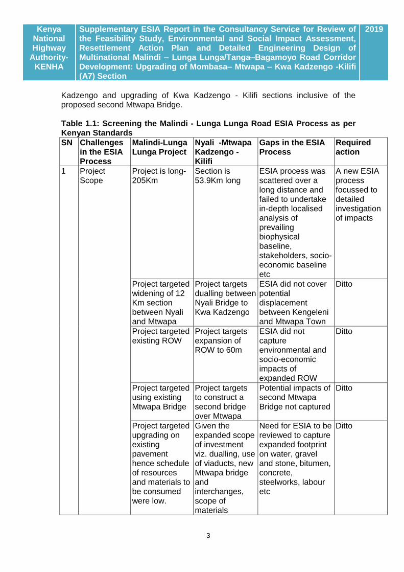
Kadzengo and upgrading of Kwa Kadzengo - Kilifi sections inclusive of the proposed second Mtwapa Bridge. Table 1.1: Screening the Malindi - Lunga Lunga Road ESIA Process as per Kenyan Standards
SN Challenges in the ESIA Process
Malindi-Lunga Lunga Project
Nyali -Mtwapa Kadzengo - Kilifi
Gaps in the ESIA Process
Required action
1 Project Scope
Project is long-205Km
Section is 53.9Km long
ESIA process was scattered over a long distance and failed to undertake in-depth localised analysis of prevailing biophysical baseline, stakeholders, socio-economic baseline etc
A new ESIA process focussed to detailed investigation of impacts
Project targeted widening of 12 Km section between Nyali and Mtwapa
Project targets dualling between Nyali Bridge to Kwa Kadzengo
ESIA did not cover potential displacement between Kengeleni and Mtwapa Town
Ditto
Project targeted existing ROW
Project targets expansion of ROW to 60m
ESIA did not capture environmental and socio-economic impacts of expanded ROW
Ditto
Project targeted using existing Mtwapa Bridge
Project targets to construct a second bridge over Mtwapa
Potential impacts of second Mtwapa Bridge not captured
Ditto
Project targeted upgrading on existing pavement hence schedule of resources and materials to be consumed were low.
Given the expanded scope of investment viz. dualling, use of viaducts, new Mtwapa bridge and interchanges, scope of materials
Need for ESIA to be reviewed to capture expanded footprint on water, gravel and stone, bitumen, concrete, steelworks, labour etc
Ditto

Kenya National Highway
Authority-KENHA
Supplementary ESIA Report in the Consultancy Service for Review of the Feasibility Study, Environmental and Social Impact Assessment, Resettlement Action Plan and Detailed Engineering Design of Multinational Malindi – Lunga Lunga/Tanga–Bagamoyo Road Corridor Development: Upgrading of Mombasa– Mtwapa – Kwa Kadzengo -Kilifi (A7) Section
2019
4
SN Challenges in the ESIA Process
Malindi-Lunga Lunga Project
Nyali -Mtwapa Kadzengo - Kilifi
Gaps in the ESIA Process
Required action
consumption is high
Given increased scope of investments and civil works, the intensity of adverse impacts (displacement, nuisances, influx of workers, soil and vegetation disturbance, disruption of services and operations) is quite high
ESIA process could not anticipate and capture impacts from an expanded project.
A new ESIA process to investigate all potential impacts
2 Time lag since grant of ESIA License
Was designed before new constitutional had operationalised devolved system of Government, new Institutions, new laws, new requirements took effect
Project being designed under new constitutional dispensation
Old ESIA did not capture the new legal, institutional and administrative order brought by the new constitution
Ditto
Since grant of ESIA process, many laws have been repealed, new ones have been enacted
ESIA process did not factor in the new legal regime e.g. EMC(Amendment) Act 2015, Water Act 2016, Land laws 2012, Environment and Land Act 2013, NLC Act 2013, County Government Act 2012, etc
Ditto

Kenya National Highway
Authority-KENHA
Supplementary ESIA Report in the Consultancy Service for Review of the Feasibility Study, Environmental and Social Impact Assessment, Resettlement Action Plan and Detailed Engineering Design of Multinational Malindi – Lunga Lunga/Tanga–Bagamoyo Road Corridor Development: Upgrading of Mombasa– Mtwapa – Kwa Kadzengo -Kilifi (A7) Section
2019
5
SN Challenges in the ESIA Process
Malindi-Lunga Lunga Project
Nyali -Mtwapa Kadzengo - Kilifi
Gaps in the ESIA Process
Required action
Population of stakeholders to the road reserve has increased since 2013
ESIA process failed to capture high pre-existing population of roadside traders and neither did it anticipate increasing population of the same.
Ditto
3 Challenges in the ESIA Process
The ESIA Report had many factual errors, mi-citations and oversights (relied on repealed laws, weak analysis of the biophysical, social and legal baseline) leading to a weak ESMP
Need to for the ESMP to be based on a comprehensive analysis of potential impacts anchored on facts on the prevailing baseline and trends.
Ditto
ESIA failed to capture localised strategic impacts such as emergence of new trunk roads, new growth areas, associated with an upgraded road and which would create secondary impacts
1.3.4: Outcome Screening against AfDB Integrated Social Safeguards (ISS)
Comprehensive analysis of the AfDB’s Integrated Safeguard Polices is presented in Chapter Three below. Screened against the five AfDB ISS, it is clear that the proposed dualling of the Mombasa – Mtwapa – Kwa Kadzengo and upgrading of Kwa Kadzengo - Kilifi section of the A7 highway triggers all five Operational Safeguards for reasons as follows:-

Kenya National Highway
Authority-KENHA
Supplementary ESIA Report in the Consultancy Service for Review of the Feasibility Study, Environmental and Social Impact Assessment, Resettlement Action Plan and Detailed Engineering Design of Multinational Malindi – Lunga Lunga/Tanga–Bagamoyo Road Corridor Development: Upgrading of Mombasa– Mtwapa – Kwa Kadzengo -Kilifi (A7) Section
2019
6
Table 1.2: Screening against AfDB Operational Safeguards AfDB Operational Safeguard
Focus Status Reasons
Operational Safeguard 1:
Environmental and social assessment
Triggered Project entails widening the road corridor and will thus trigger wider non-anticipated scope of impacts which require additional ESIA
Operational Safeguard 2:
Involuntary resettlement land acquisition, population displacement and compensation
Triggered For the same reason, scope of displacement will be bigger
Operational Safeguard 3:
Biodiversity and ecosystem services
Triggered Road widening will touch on biodiversity conservation areas of Bamburi Forest and Kadzengo marshlands which were previously non-anticipated.
Operational Safeguard 4:
Pollution prevention and control, hazardous materials and resource efficiency
Triggered Impacts of road widening require to be assessed anew
Operational Safeguard 5:
Labour conditions, health and safety
Triggered Implications of expanded scope of project on labour conditions, health and safety require to be looked a new
1.3.5: Recommended way-forward with the ESIA Process
Borne of the analysis summarised in Tables 1.1 and 1.2 above, the recommendation was to proceed with a supplementary ESIA process aimed at bridging all observed gaps with a view to generating a new ESMP based on which, an application for renewal of the EIA License would be made. However, given that the Project already underwent the Statutory ESIA Process, the current study is only supplementary and depending on advice from NEMA, may not be subject to all statutory obligations required of new ESIA Studies.
1.3.6: Scale of ESIA Study conceived and designed
The Second Schedule of EMCA specifies projects that require to be subjected to EIA studies. Screened against this Schedule, the proposed dualling of the Mombasa –Mtwapa – Kadzengo and upgrading the Kwa Kadzengo - Kilifi (A7) Road was found to bear features that would warrant a full cycle ESIA Study. Core concerns include:-
Culturally sensitive sites: The section of the A7 highway targeted for upgrading traverses several sites of cultural interest including the Kisauni Bell Tower (Kengeleni Tower) gazetted as a National Monument by the

Kenya National Highway
Authority-KENHA
Supplementary ESIA Report in the Consultancy Service for Review of the Feasibility Study, Environmental and Social Impact Assessment, Resettlement Action Plan and Detailed Engineering Design of Multinational Malindi – Lunga Lunga/Tanga–Bagamoyo Road Corridor Development: Upgrading of Mombasa– Mtwapa – Kwa Kadzengo -Kilifi (A7) Section
2019
7
NMK since 1983, the Frere Town Community Church among others which required clear mapping for preservation as part of the ESIA process.
Ecologically Sensitive sites: Sites that will require focused attention during an ESIA process include Bamburi Forest Block and its Haller Park, the Mtwapa Creek Ecosystem, seasonal lakes (marshlands) such as Kwa Kadzengo, water courses such as Mtopanga, Bongolo among others.
Drainage challenges: On account of a largely flat, sometimes internally draining topography, the entire A7 highway section between Kongowea and Mtwapa Bridge suffers a huge drainage problem which spills over into sections of the Nyali Estate.
The Question of economic displacement: The A7 Road between Mombasa and Mtwapa is an Economic Corridor. There are many, citizens deriving livelihoods through trading in the reserve of the A7 Highway and their potential displacement in road upgrading is currently a major concern. As well, Mtwapa is a residential Town which houses labour for Mombasa Town and the latter is transported through the A7 Road. Any disruption in passenger transport is likely to cause economic shocks in Mombasa.
Given these considerations, a study process culminating in a Supplementary ESIA Study Report was conceived and implemented in Line with Cap 387 and its tools.
Towards preparation of an ESIA Study Report, the NEMA screening procedure as expounded in Legal Notice 101 of June 2003 was adopted. Section 6 of part 1 of the LN 101 stipulates that “An application for an Environmental Impact Assessment License shall be in the form of a Project Report in the form set out in the First Schedule to these Regulations, and the applicant shall submit the application together with the prescribed fee to the Authority… Section 7(1) of Part 11 of the Legal Notice 101 specifies the contents (scope) of the project report.
A proponent shall prepare an ESIA Study Report stating: -
a) The nature of the project;
b) The Division of the project including the physical area that may be affected by the project’s activities;
c) The activities that shall be undertaken during the project construction, operation and decommissioning phases;
d) The design of the project;
e) The materials to be used, products, by-products, including waste to be generated by the project and the methods of disposal;
f) The potential environmental impacts of the project and the mitigation measures to be taken during and after implementation;
g) An action plan for the prevention and management of possible accidents during the project cycle;

Kenya National Highway
Authority-KENHA
Supplementary ESIA Report in the Consultancy Service for Review of the Feasibility Study, Environmental and Social Impact Assessment, Resettlement Action Plan and Detailed Engineering Design of Multinational Malindi – Lunga Lunga/Tanga–Bagamoyo Road Corridor Development: Upgrading of Mombasa– Mtwapa – Kwa Kadzengo -Kilifi (A7) Section
2019
8
h) A plan to ensure the health and safety of the workers and neighbouring communities;
i) The economic and socio-cultural impacts to the local community and the nation in general;
j) The project budget;
k) Any other information that the Authority may require
1.4: Procedure for Full Cycle ESIA Study
1.4.1: Data collection procedure
Data correction started with a review of available project documents with a view to understanding the scope and focus of the proposed dualling/upgrading road construction project. Simultaneously, planning reports, baseline reports etc. for the Mombasa and Kilifi Counties were reviewed so as to provide an insight into the socio-environmental baseline of the project area. Preliminary opinions formed from such literature review were re-validated during fieldwork undertaken on the ground.
1.4.2: Field Work and Public Consultations
Fieldwork entailed three activity groups namely:-
On the ground investigations: Reconnaissance surveys along the route of traverse were conducted by the Study Team so as to familiarize with site conditions and identify transects/ hotspots for further detailed investigation. Selected sites such as the sensitive ecological environments including forests, e.g. Bamburi quarry rehabilitation forests and Kwa Kadzengo marshlands were subjected to further detailed investigations and screening so as to document baseline conditions as a basis for predicting impacts.
Stakeholder Consultation: This activity whose progress and outcomes are reported in Chapter Five was undertaken in fulfilment of requirements of both the National Constitution 2010 and EMCA 1999 which require all project development to be preceded by mandatory public consultation.
1.4.3: Data Analysis and Impact Prediction
Upon data analysis, potential environmental impacts (both positive and adverse) were predicted based mainly on concerns raised by stakeholder and expert observations on the ground and available tools. The magnitude, significance, and acceptability of predicted impacts were evaluated with a view to determining whether observed adverse impacts are significant enough to warrant mitigation. Impacts were further screened for occurrence and significance of residual (those which cannot be mitigated satisfactorily) and cumulative impacts with a view to providing a basis of making recommendations on the way forward for the project. Appendix 1.3 provides the World Bank checklist for Impact Assessment in road upgrading projects.
Kenya National Highway
Authority-KENHA
Supplementary ESIA Report in the Consultancy Service for Review of the Feasibility Study, Environmental and Social Impact Assessment, Resettlement Action Plan and Detailed Engineering Design of Multinational Malindi – Lunga Lunga/Tanga–Bagamoyo Road Corridor Development: Upgrading of Mombasa– Mtwapa – Kwa Kadzengo -Kilifi (A7) Section
2019
9
1.4.4: Identification of Mitigation Measures
Measures or interventions necessary to minimize, reduce, avoid or offset identified adverse impacts were evaluated and presented in form of an Impact Mitigation Plan for the proposed development. Such evaluation also included an assessment of the No-Go Option as reported in Chapter 6.
1.4.5: Identification of Monitoring Requirements
As part of the study output, a monitoring and evaluation program was developed as a means for monitoring compliance during implementation of proposed mitigation measures and to ensure continuous generation of project data and information.
THE ESIA TEAM
This Environmental and Social Impact Assessment study was undertaken by a multi-disciplinary team bringing together skills as follows:-
Mr. Michael Wairagu- Environmental and Social Safeguards expert
Ms Monicah Nyang - EIA Lead Expert / Sociologist
Margaret Kirugo-Assistant Sociologist
Mr. Alex Mwalimu-Ornithologist
Edwin Owino-Taxonomist/Biometrician
CVs for this Team are attached as Appendix 1.2 to this report.
PRESENTATION OF THE REPORT
The EIA study as proposed above culminated with production of this ESIA Study Report designed to ensure that the proposed development complies with the Environmental Management and Coordination Act (EMCA, 1999) and the Environmental management and Coordination (Amendment) Act 2016. The report is organized in 11 chapters as outlined below: -
Chapter One gives Background Information to the Study
Chapter Two provides a description of the Project
Chapter Three outlines the Policy, Legal and Regulatory Framework
Chapter Four outlines the Baseline Information of the Study Area
Chapter Five outlines the socio-economic baseline
Chapter Six provides empirical characterization of the project area
Chapter Seven provides an analysis of Potential Impacts of the Project
Chapter Eight outlines outcome of the Public Participation Process
Kenya National Highway
Authority-KENHA
Supplementary ESIA Report in the Consultancy Service for Review of the Feasibility Study, Environmental and Social Impact Assessment, Resettlement Action Plan and Detailed Engineering Design of Multinational Malindi – Lunga Lunga/Tanga–Bagamoyo Road Corridor Development: Upgrading of Mombasa– Mtwapa – Kwa Kadzengo -Kilifi (A7) Section
2019
10
Chapter Nine analyses Potential Impacts
Chapter Ten outlines the Environment and Social management Framework
Chapter Eleven concludes the Study.
Volume Two : Appendices to the Study

Kenya National Highway
Authority-KENHA
Supplementary ESIA Report in the Consultancy Service for Review of the Feasibility Study, Environmental and Social Impact Assessment, Resettlement Action Plan and Detailed Engineering Design of Multinational Malindi – Lunga Lunga/Tanga–Bagamoyo Road Corridor Development: Upgrading of Mombasa– Mtwapa – Kwa Kadzengo -Kilifi (A7) Section
2019
11
CHAPTER TWO: PROJECT DESCRIPTION 2.1: OWNERSHIP
This is a Project of the Government of Kenya implemented by the Kenya National Highways Authority (KENHA) with support of the African Development Bank.
2.2: PROJECT SCOPE
2.2.1: Project Components
Fig 2.1 provides a geographic overview of the Mombasa-Mtwapa-Kadzengo-Kilifi Road Project. The Project comprises of two sections amounting to 53.9 km as follows:-
Linear Profile: Detailed components of the Project deemed to have displacement impact and which are the subjects of this ESIA Study are summarized in Table 2.1 below while Figure 2.1 below traces the entire traverse of the Project. The Project is packaged into two lots as follows:-
Table 2.1: Dimensions of the Road
Project Lot Linear extension Length (Km)
One Nyali Bridge to Mtwapa Bridge 13.5
Two Mtwapa Bridge to Kadzengo 7.3
Kadzengo to Kilifi Bridge 33.1
Total length 53.9
Lot 1 starts from Mombasa (Nyali Bridge) and runs through Bombululu, Bamburi and Shanzu to terminate at the beginning of the Mtwapa Bridge (excluding the bridge) with a total length of 13.5 Km.
Lot 2 starts from Mtwapa Bridge (Including Bridge) through Mtwapa Township, Kikambala, Kanamai, Kwa Kazdengo all through to Kilifi Bridge, with a total length of 40.4km. The scope for this lot will include preliminary and detailed engineering design of a new dual carriageway Mtwapa Bridge (long span bridge).
Kenya National Highway
Authority-KENHA
Supplementary ESIA Report in the Consultancy Service for Review of the Feasibility Study, Environmental and Social Impact Assessment, Resettlement Action Plan and Detailed Engineering Design of Multinational Malindi – Lunga Lunga/Tanga–Bagamoyo Road Corridor Development: Upgrading of Mombasa– Mtwapa – Kwa Kadzengo -Kilifi (A7) Section
2019
12
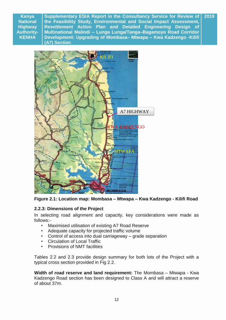
Figure 2.1: Location map: Mombasa – Mtwapa – Kwa Kadzengo - Kilifi Road
2.2.3: Dimensions of the Project
In selecting road alignment and capacity, key considerations were made as follows:-
• Maximised utilisation of existing A7 Road Reserve • Adequate capacity for projected traffic volume • Control of access into dual carriageway – grade separation • Circulation of Local Traffic • Provisions of NMT facilities
Tables 2.2 and 2.3 provide design summary for both lots of the Project with a typical cross section provided in Fig 2.2. Width of road reserve and land requirement: The Mombasa – Mtwapa - Kwa Kadzengo Road section has been designed to Class A and will attract a reserve of about 37m.
KILIFI
MTWAPA
KWA KADZENGO
A7 HIGHWAY

Kenya National Highway
Authority-KENHA
Supplementary ESIA Report in the Consultancy Service for Review of the Feasibility Study, Environmental and Social Impact Assessment, Resettlement Action Plan and Detailed Engineering Design of Multinational Malindi – Lunga Lunga/Tanga–Bagamoyo Road Corridor Development: Upgrading of Mombasa– Mtwapa – Kwa Kadzengo -Kilifi (A7) Section
2019
13
Fig 2.2: Standard cross-section design for Project Road Tables 2.2: Lot 1-Mombasa to Mtwapa Bridge Carriageway
Road Item Start End Length- km Direction Comment’s
Carriageway 0+000 13+500 13.5 LHS Northbound RHS Southbound
Carriageway designed with many buildings avoided.
LHS Service Road
0+000 4+660 4.66 One way Northbound Sections next to Haller Park and Bamburi forest trails (km 4+660 – 10+700 LHS) were not provided with service roads other than on the approaches to Junctions. A two way side road was allowed between Serena Road and Karisa Maitha Road and allowing access to Shimo la tewa Prison.
5+320 6+280 0.96 One way Northbound Ramps
6+720 7+700 1.00 One way Northbound Ramps
9+800 11+960 2.16 One way Northbound
11+960 13+160 1.20 Two way
13+160 13+500 0.34 One way Northbound
Total 10.32
RHS Service Road
0+000 11+020 11.02 One way Southbound RHS service road was terminated between km 11+020 to 11+540 because of dispersed institutional developments. 11+540 13+300 1.76 One way Southbound
Total 12.8

Kenya National Highway
Authority-KENHA
Supplementary ESIA Report in the Consultancy Service for Review of the Feasibility Study, Environmental and Social Impact Assessment, Resettlement Action Plan and Detailed Engineering Design of Multinational Malindi – Lunga Lunga/Tanga–Bagamoyo Road Corridor Development: Upgrading of Mombasa– Mtwapa – Kwa Kadzengo -Kilifi (A7) Section
2019
14
Tables 2.3: Lot 2-Mtwapa Bridge to Kwa Kadzengo to Kilifi
Road Item Start End Length (km)
Direction Comment’s
Carriageway 13+500 13+620 0.12 LHS Northbound RHS Southbound
New Mtwapa Bridge
13+620 15+340 1.72 LHS Northbound RHS Southbound
Piped drainage adopted. Cross section reviewed to restrict construction within existing 36.5m road reserve.
15+340 15+860 5.65 LHS Northbound RHS Southbound
Widened cross section to allow At Grade U-turn
15+860 19+380 3.52 LHS Northbound RHS Southbound
Dual Carriageway designed through peri-urban to rural area.
19+380 19+880 0.5 LHS Northbound RHS Southbound
Widened cross section to allow At Grade U-turn
19+880 20+750 0.87 LHS Northbound RHS Southbound
Dual Carriageway designed through peri-urban to rural area.
20+750 53+900 33.15 Single carriageway Kwa Kadzengo – Kilifi section
Benching to be done to widen cross section.
Total 40.4
LHS Service Road
13+620 15+380 2.68 One way Northbound
Service road provided on urbanised section only
16+660 17+440 0.78 One way Northbound Ramps
18+260 18+940 0.68 One way Northbound
Kanamai shopping centre
Total 4.14
RHS Service Road
13+620 15+380 2.68 One way Southbound
Service road provided on urbanised section only
16+660 17+440 0.78 One-way Southbound Ramps
18+260 18+940 0.68 One way Southbound
Kanamai shopping centre
Total 4.14
2.2.4: Structures in the Project
Fig. 2.3 provides an indication of the main structures anticipated in the Road Dualling Project. Main objectives in providing structures are as follows:-
Vehicular traffic requirement in order to improve traffic flow, traffic safety and level of service;
Pedestrian traffic in order to enable pedestrians navigate across highway safely and efficiently;
Hydrology and hydraulic requirement in order to facilitate storm water to be conveyed safely and efficiently without impeding traffic flow;

Kenya National Highway
Authority-KENHA
Supplementary ESIA Report in the Consultancy Service for Review of the Feasibility Study, Environmental and Social Impact Assessment, Resettlement Action Plan and Detailed Engineering Design of Multinational Malindi – Lunga Lunga/Tanga–Bagamoyo Road Corridor Development: Upgrading of Mombasa– Mtwapa – Kwa Kadzengo -Kilifi (A7) Section
2019
15
General safety requirement to ensure all users of the road or highway do so safely and cost effectively;
Socio-economic impact to consider minimization or mitigate adverse socio- economic impact on potential Project Affected Persons (PAPs)
Junctions: A total of nine junction points will be provided as summarised in Table 2.4. Table: 2.4: Main junctions
Drainage Structures: A comprehensive analysis of the drainage condition within the traverse is provided in Chapter Four below. The main drainage feature within the Project Road is the Mtwapa Bridge with Mtopanga and Bongolo being the other minor structure. A new bridge across Mtwapa will be provided. 2.3: ACTIVITIES IN PROJECT IMPLEMENTATION
This section provides excerpts from the Engineering Design Report providing a highlight of post-design activities to be put in place to ensure accomplishment of project goals as defined. These are essentially the activities likely to account for all social and environmental impacts ensuing from the project. Construction phase activities can be grouped as follows: -
(i) Construction of Resident Engineer and Contractor Camps:
This will include setting up of a complex comprised of Offices, laboratory, accommodation, maintenance unit, material storage yard, fuel dump, parking, messing area etc for both the RE and Contractor. Ordinarily and, depending on scope of construction, one camp is adequate to meet such needs but, given logistical challenges posed by physical barriers, there may be need to set up 3 camps to cater for Lot One and Two separately. Among other implication, such camps will require additional land acquisition.

Kenya National Highway
Authority-KENHA
Supplementary ESIA Report in the Consultancy Service for Review of the Feasibility Study, Environmental and Social Impact Assessment, Resettlement Action Plan and Detailed Engineering Design of Multinational Malindi – Lunga Lunga/Tanga–Bagamoyo Road Corridor Development: Upgrading of Mombasa– Mtwapa – Kwa Kadzengo -Kilifi (A7) Section
2019
16
(ii) Road forming Stage:
This will entail activities as follows: -
Stripping of top soil: Loose organic soil from the entire area targeted for road construction (pavement, shoulders and drainage) will be stripped and stockpiled for re-use in grassing, planting and rehabilitation of borrow sites.
Relocation of services: Civil works will be preceded by relocation and repair of all utilities mainly power and water mains to ensure un-interrupted supply. The utilities targeted specific action include: -
Numerous 132kV power transmission lines
Water supply mains: Malindi to North Coast
Material borrowing: Gravel (Murram) and hard stone material for construction of both sub base and subgrade will be quarried from designated material sites and transported to the construction/material bulking sites. Quantity of materials to be sourced is approximately 1,085,910m3 of gravel and 951,100m3 of hard stone aggregates. Gravelling will also extend to detours, deviations, junctions and accesses.
The Bituminous Surface: This will entail application of bituminous spray coat to the road, spreading chippings on top and rolling the layer. This will be preceded by two layers of bituminous mix (Dense Bitumen Macadam and Asphalt Concrete). Below the bituminous layers will be a layer of graded Crushed Stone formed from the aggregates of various sizes and compacted.
(iii) Construction of Drainage Structures:
Second to road formation and construction of bridges and other drainage structure; - Culverts, headwalls for culverts and improvement of other drainage and soil erosion protection works comprise the most costly aspect of road development. Accommodation of traffic crossing through the works;
(iv) Road Furniture:
This will entail provision and erection of new road furniture (guardrails, road signs, marker posts, road studs and speed bumps);
(v) Landscaping works:
This target restoration/ stabilization of exposed slopes through grassing followed by restocking of displaced trees. Activities will include top-soiling, grass planting and tree planting followed by watering until growth is ensured.
2.4: ACTIVITIES DURING OPERATION AND DECOMMISSIONING
The Contractor will be required to maintain the road for a period of 24months during which, the main items of work will include:-
Repair of any defects on the road and road furniture;
Kenya National Highway
Authority-KENHA
Supplementary ESIA Report in the Consultancy Service for Review of the Feasibility Study, Environmental and Social Impact Assessment, Resettlement Action Plan and Detailed Engineering Design of Multinational Malindi – Lunga Lunga/Tanga–Bagamoyo Road Corridor Development: Upgrading of Mombasa– Mtwapa – Kwa Kadzengo -Kilifi (A7) Section
2019
17
Cleaning and de-silting culverts and road side drains;
Regular road markings;
Grass and bush clearing within the road reserve;
Removal of construction camps, removal of un-used material stockpiled on the road, tidying and general cleanness of the road and construction sites.
2.5: PROJECT JUSTIFICATION
Mombasa is the second largest city in Kenya and the major gateway to East and Central Africa, therefore, serving a great hinterland with both export and import needs. The current road network was originally designed for low traffic, with the main purpose of facilitating movement of vehicles from the mainland to the islands CBD and the port of Mombasa. Most of the road network has not been improved and cars and human traffic have continually increased over the years leading to congestion. The proposal to upgrade the Mombasa – Mtwapa – Kwa Kadzengo - Kilifi Road is driven by the desire to ease traffic flow between Mombasa, Mtwapa and Kilifi especially in the wake of development of the proposed Mombasa Northern Bypass Road.
2.6: TOTAL COST OF THE PROJECT
From Bills of Quantities accruing from activities, the Project is estimated to cost Kshs. 21.69 Billion (usd 216.9 million).

Kenya National Highway
Authority-KENHA
Supplementary ESIA Report in the Consultancy Service for Review of the Feasibility Study, Environmental and Social Impact Assessment, Resettlement Action Plan and Detailed Engineering Design of Multinational Malindi – Lunga Lunga/Tanga–Bagamoyo Road Corridor Development: Upgrading of Mombasa– Mtwapa – Kwa Kadzengo -Kilifi (A7) Section
2019
18
CHAPTER THREE: POLICY, LEGAL AND ADMINISTRATIVE FRAMEWORK
This chapter outlines the policy, legal, regulatory and institutional framework for Environmental Management in Kenya which calls for compliance by all development projects including those of the road transport sub- sector.
3.1: THE POLICY FRAMEWORK
3.1.1: The GOK Policy Framework
Sessional Paper Number 10 of 2012 on Kenya Vision 2030
Sessional Paper Number 10 of 2012 on Kenya Vision 2030 is the National Policy Economic Blueprint that entrenches Kenya Vision 2030 as the long term development strategy for Kenya towards achieving a “globally competitive and prosperous country with a high quality of life by 2030. Specifically, Vision 2030 aims at transforming Kenya into “a newly industrializing, middle income country providing a high quality of life to all its citizens in a clean and secure environment as anticipated in the Millennium Development Goals which is anchored on 3 pillars1
The Economic Pillar aims to achieve a sustained annual growth rate of 10% by 2030,
The Social Pillar seeks to create a just, cohesive and equitable social development, and;
The Political Pillar envisions a democratic system that is issue based, people cantered, results oriented and is accountable to the public.
The Kenya Vision 2030 is being implemented in five-year successive Medium Term Plans (MTP). The first plan covered the period 2008-2012. The Medium-Term Plan (MTP 2013-17) is the second in a series of successive 5-year plans. The second MTP 2013-2017 draws on lessons learnt in implementing the first MTP. It seeks to implement the flagship projects identified under Vision 2030 over the five-year period together with incomplete flagship and other projects and programs in the previous Medium-Term Plan. It will also take due cognizance of the devolved structure of government following promulgation of the Constitution of Kenya 2010 and recent discovery of oil and mineral resources.
By promoting investment in the six priority sectors of tourism; agriculture; wholesale and retail trade; manufacturing; it enabled services (previously known as business process outsourcing); and financial services identified under the Economic Pillar 2, Vision 2030 seeks to achieve and sustain annual GDP growth rate at 10% up to 2030 and thereby generating resources required to address
1 Kenya Vision 2030, http://www.vision2030.go.ke/ (accessed August 26, 2014)
2 Recently, a seventh Sector on Oil and Mineral Processing has been added to the economic pillar (GOK, 2013: Mombasa County Development Profile).

Kenya National Highway
Authority-KENHA
Supplementary ESIA Report in the Consultancy Service for Review of the Feasibility Study, Environmental and Social Impact Assessment, Resettlement Action Plan and Detailed Engineering Design of Multinational Malindi – Lunga Lunga/Tanga–Bagamoyo Road Corridor Development: Upgrading of Mombasa– Mtwapa – Kwa Kadzengo -Kilifi (A7) Section
2019
19
other MDGs. This creates the urgent need of investing in both Flagship Projects and requisite infrastructure. Against this backdrop, the proposed upgrading of Mombasa – Mtwapa – Kwa Kadzengo – Kilifi Road linking traffic that bypass Mombasa Town via Mombasa Northern Bypass as currently conceived is fully harmonized with the vision as it will touch on all six areas identified under the Economic Pillar.
With regard to environmental quality, Vision 2030 anticipates a Kenyan nation characterized by a clean, secure and sustainable environment by 2030 and sets the goals for 2012 and which are yet to be achieved as: (i) to increase forest cover from less than 3% at present to 4% and (ii) to lessen by half all environment-related diseases. Specific strategies will involve promoting environmental conservation in order to provide better support to the economic pillar flagship projects and for the purposes of achieving the Millennium Development Goals (MDGs); improving pollution and waste management through the design and application of economic incentives; and the commissioning of public-private partnerships (PPPs) for improved efficiency in water and sanitation delivery. Kenya will also enhance disaster preparedness in all disaster-prone areas and improve the capacity for adaptation to global climate change. In addition, the country will harmonize environment-related laws for better environmental planning and governance.
The Millennium Development Goals for 2015:
The Millennium Development Goals time framework lapsed in June 2015 and has since been replaced by the Sustainable Development Goals (See next section). However, given the intensive gains made by the GOK in addressing these goals and their continued relevance, a brief overview of the same is considered relevant to this report.
The Millennium Development Goals (MDGs) consisted of eight goals set to be achieved by 2015 that responded to the world's main development challenges and were drawn from the actions and targets contained in the Millennium Declaration that was adopted by 189 nations-and signed by 147 heads of state and governments during the UN Millennium Summit in September 2000. They include:
Halving extreme poverty and hunger (1990-2015);
Achieving universal primary education (by 2015);
Promoting gender equality (by 2015);
Reducing under-five mortality by two-thirds (1990-2015);
Reducing maternal mortality by three quarters (1990·2015);
Reversing the trend of HIV/AIDS, malaria and Tuberculosis (by 2015);
Ensuring environmental sustainability (by 2015);

Kenya National Highway
Authority-KENHA
Supplementary ESIA Report in the Consultancy Service for Review of the Feasibility Study, Environmental and Social Impact Assessment, Resettlement Action Plan and Detailed Engineering Design of Multinational Malindi – Lunga Lunga/Tanga–Bagamoyo Road Corridor Development: Upgrading of Mombasa– Mtwapa – Kwa Kadzengo -Kilifi (A7) Section
2019
20
Developing global partnership for development with clear targets for aid, trade and debt relief (by 2015).
Nationally, the GOK has taken bold steps to domesticate the MDGs as exemplified by i) investment in the Poverty Reduction Strategy Paper (PRSP) process through which participatory mapping of poverty incidence at both District and National Level was undertaken, ii) implementation of the Economic Recovery Strategy for Wealth and Employment Creation, and iii) implementation of projects that directly confront specific aspects of the MDGs. By anchoring the Economic Pillar of Vision 2030 which seeks to generate resources needed to address MDGs, implementation of rural infrastructure as proposed for the Project Road is attuned to the national and indeed global agenda for economic and social development.
Sustainable Development Goals (SDG`s) The SDG`s consist of 17 goals to be achieved by 2030. They constitute an integrated, indivisible set of global priorities for sustainable development. Their target is to build on the foundation laid by the MDGs, by seeking to complete the unfinished business of the MDGs, and respond to new challenges. SDG`s are accompanied by targets and will be further elaborated through indicators focused on measurable outcomes. The goals and targets integrate economic, social and environmental aspects and recognize their inter-linkages in achieving sustainable development in all its dimensions. Each government will set its own national targets guided by the global level of ambition but taking into account national circumstances. These goals include; Table 3-1 Sustainable development goals
Goal 1 End poverty in all its forms everywhere
Goal 2 End hunger, achieve food security and improved nutrition and promote sustainable agriculture
Goal 3 Ensure healthy lives and promote well-being for all at all ages
Goal 4 Ensure inclusive and equitable quality education and promote lifelong learning opportunities for all
Goal 5 Achieve gender equality and empower all women and girls
Goal 6 Ensure availability and sustainable management of water and sanitation for all
Goal 7 Ensure access to affordable, reliable, sustainable and modern energy for all
Goal 8 Promote sustained, inclusive and sustainable economic growth, full and productive employment and decent work for all
Goal 9 Build resilient infrastructure, promote inclusive and sustainable industrialization and foster innovation
Goal 10 Reduce inequality within and among countries

Kenya National Highway
Authority-KENHA
Supplementary ESIA Report in the Consultancy Service for Review of the Feasibility Study, Environmental and Social Impact Assessment, Resettlement Action Plan and Detailed Engineering Design of Multinational Malindi – Lunga Lunga/Tanga–Bagamoyo Road Corridor Development: Upgrading of Mombasa– Mtwapa – Kwa Kadzengo -Kilifi (A7) Section
2019
21
Goal 11 Make cities and human settlements inclusive, safe, resilient and sustainable
Goal 12 Ensure sustainable consumption and production patterns
Goal 13 Take urgent action to combat climate change and its impacts*
Goal 14 Conserve and sustainably use the oceans, seas and marine resources for sustainable development
Goal 15 Protect, restore and promote sustainable use of terrestrial ecosystems, sustainably manage forests, combat desertification, and halt and reverse land degradation and halt biodiversity loss
Goal 16 Promote peaceful and inclusive societies for sustainable development, provide access to justice for all and build effective, accountable and inclusive institutions at all levels
Goal 17 Strengthen the means of implementation and revitalize the global partnership for sustainable development
The implementation of the sustainable development goals will depend on a global partnership for sustainable development with the active engagement of Governments, as well as civil society, the private sector and the United Nations system.
Sessional Paper No 1 of 1996 on Environment and Development:
Sessional Paper No 1 of 1996 is the official statement on national policy on environment and was released in 1996 following recommendations of the National Environment Action Plan (NEAP) of 1994. The NEAP process had been launched earlier in 1992 following the Country’s participation in the United Nations Conference on Environment and Development (UNCED) in Rio de Janeiro during which Kenya alongside other nations became a signatory to Agenda 21 which called on all nations to pay closer attention to environmental management at national level. Through Sessional Paper No 1 of 1996, the Kenya Government guarantees every citizen the inalienable right to a clean and healthy environment and commits to pursue a policy strategy of integrating environmental sensitivity into national development planning process and sets broad policy objectives as follows:
Optimal use of natural land and water resources in improving the quality of human environment;
Sustainable use of natural resources to meet the needs of the present generations while preserving their ability to meet the needs of future generations;
Integration of environmental conservation and economic activities into the process of sustainable development;
Meeting of national goals and international obligations by conserving bio-diversity, arresting desertification, mitigating effects of disasters,

Kenya National Highway
Authority-KENHA
Supplementary ESIA Report in the Consultancy Service for Review of the Feasibility Study, Environmental and Social Impact Assessment, Resettlement Action Plan and Detailed Engineering Design of Multinational Malindi – Lunga Lunga/Tanga–Bagamoyo Road Corridor Development: Upgrading of Mombasa– Mtwapa – Kwa Kadzengo -Kilifi (A7) Section
2019
22
protecting the ozone layer and maintaining an ecological balance on earth.
Among other provisions, Sessional Paper No. 1 of 1996 also sets out sectoral priorities for environmental sustainability which in most cases have been operationalized through formulation of guidelines for quality and environmental management in respective sectors. The Environment Management and Coordination Act (EMCA, 1999) has since also been enacted to secure implementation of the national policy on environment.
Execution of an ESIA Study for the Project Road in line with Cap 387 and LN 101 of EMCA will secure harmony with the aspirations of the National Policy on Environment and Development.
The National Poverty Eradication Plan
The NPEP has the objective of reducing the incidence of poverty in both rural and urban areas by 50 percent by the year 2015; as well as strengthening the capabilities of the poor and vulnerable groups to earn income. It also aims to narrow gender and geographical disparities and create a healthy, better-educated and more productive population. This plan has been prepared in line with the goals and commitments of the World Summit for the Social Development (WSSD) of 1995. The plan focuses on the four WSSD themes of the poverty eradication; reduction of unemployment; social integration of the disadvantaged people and the creation of an enabling economic, political, and cultural environment. This plan is to be implemented by the Poverty Eradication Commission (PEC) formed in collaboration with Government Ministries, community-based organizations and private sector.
The Poverty Reduction Strategy Paper (1999)
This strategy paper was published by the Government in 2001. The two key goals of the strategy are poverty reduction and economic growth. The document outlines the priorities and measure necessary for poverty reduction and economic growth. The objectives of economic growth and poverty reduction are borne out of realization that economic growth is not a sufficient condition to ensure poverty reduction. In this regard, measures geared towards improved economic performance and priority actions that must be implemented to reduce the incidence of poverty among Kenyans have been identified. With respect to the environment the paper proposes that adequate awareness be created among stakeholders regarding environmental costs and benefits. It further calls for community involvement and participation in environmental management and conservation.
Towards ensuring harmony with this policy thrust, the ESMP requires priority job placement to be accorded to residents of the traverse area.
Sessional Paper No. 3 of 2009 on National Land Policy

Kenya National Highway
Authority-KENHA
Supplementary ESIA Report in the Consultancy Service for Review of the Feasibility Study, Environmental and Social Impact Assessment, Resettlement Action Plan and Detailed Engineering Design of Multinational Malindi – Lunga Lunga/Tanga–Bagamoyo Road Corridor Development: Upgrading of Mombasa– Mtwapa – Kwa Kadzengo -Kilifi (A7) Section
2019
23
The National Land Policy was formulated with the aim of securing rights over land and provide for sustainable growth, investment and reduction of poverty in line with Government overall development objectives. The policy will offer a framework of policies and laws designed to ensure the maintenance of a system of land administration and management that will provide:
(a) All citizens with opportunity to access and beneficially occupy and use land;
(b) Economically viable, socially equitable and environmentally sustainable allocation and use of land;
(c) Efficient, effective and economical operation of land markets;
(d) Efficient and effective utilization of land and land-based resources; and
(e) Efficient and transparent land dispute resolution mechanisms.
Requirements of this Policy will be triggered in the project which will entail land acquisition towards creating a reserve for the new roads. A comprehensive Resettlement Action Plan will be developed to guide resolution of all displacement impacts associated by the Road.
The Mombasa County Integrated Development Plan 2013-2017
This County Government of Mombasa has already developed a County Integrated development plan which is modelled along the Vision 2030 format and cascades down the various pillars to relevant issues within the County.
The Strategy paper outlines the National Status and aspirations for each pillar, to provide a background to the County situation analysis and Strategy. On infrastructure, the vision is “to provide cost-effective world -class infrastructure facilities and services in support of Vision 2030”. Poor infrastructure has been identified as a major constraint to doing business. It’s repeatedly cited as a necessity in improving the livelihoods by people living farming and pastoralist areas.
The CIDP`s (2013-2017) operating Vision is to make Mombasa County a vibrant modern regional and commercial hub with a high standard of living for its residents. This vision appreciates that Infrastructure is a basic pillar for global competitiveness and a foundational enabler towards the county`s vision. Improving transport infrastructure in the county is primarily aimed at reducing traffic congestion within the CBD and this will eventually be achieved by offering various planned alternatives including;
1. Water transport is likely to contribute to a reduction of transport congestion in Mombasa if it is made attractive.
2. If use of cars in Mombasa is discouraged at the same time increasing parking fee.
3. Construction of commuter railway from west mainland to the island, from CBD to Nyali and on to the Likoni ferry.
4. Construction of a second Nyali Bridge between Tudor area to Mishomoroni
Kenya National Highway
Authority-KENHA
Supplementary ESIA Report in the Consultancy Service for Review of the Feasibility Study, Environmental and Social Impact Assessment, Resettlement Action Plan and Detailed Engineering Design of Multinational Malindi – Lunga Lunga/Tanga–Bagamoyo Road Corridor Development: Upgrading of Mombasa– Mtwapa – Kwa Kadzengo -Kilifi (A7) Section
2019
24
5. Construction of the Dongo Kundu Bypass linking Port Reitz to Mainland South.
6. Improvement of ferry services at Likoni and Mtongwe with new vessels and reconstructed approach roads.
7. Construction of a marshalling yard to take care of heavy commercial vehicles.
8. Construction of a bus terminal for public transport.
Essentially, the proposed upgrading of the Mombasa-Mtwapa-Kadzengo-Kilifi Road is aligned with stated strategies for economic transformation in the County. The proposed road upgrading project enjoys overwhelming support within the County leadership.
The Kilifi County Integrated Development Plan 2013-2017
The Kilifi County is also faced by the challenge of poor roads. The CIDP`s potential strategic policy thrusts for the poor roads in the county include; construction of dual carriage roads for busy roads like the Mtwapa –Malindi road, opening up of bypasses, opening of new roads and classification of roads.
The immediate objective is to increase the number of roads in good condition by 60% by the year 2017, increase the transport and communication efficiency by 50% and have all the roads accessible throughout the year.
Essentially, the development of the Project Road is in line with the CIDP`s strategic policy thrusts on roads. Indeed, a big section of the bypass road traverses Kilifi County and this has received overwhelming support from the public.
3.1.2: Operational Standards of the African Development Bank
According the AfDB, environmental and social sustainability is a key to economic
growth and poverty reduction in Africa. The Bank’s Strategy for 2013-2022
emphasises the need to assist regional member countries in their efforts to
achieve inclusive growth and transition to green growth. In addition, the Bank is
committed to ensuring the social and environmental sustainability of the projects
it supports. The ISS is designed to promote the sustainability of project
outcomes by protecting the environment and people from the potentially adverse
impacts of projects. The safeguards aim to:
Avoid adverse impacts of projects on the environment and affected
people, while maximising potential development benefits to the extent
possible;
Minimise, mitigate, and/ or compensate for adverse impacts on the
environment and affected people when avoidance is not possible; and
Help borrowers/clients to strengthen their safeguard systems and develop
the capacity to manage environmental and social risks. The Bank requires

Kenya National Highway
Authority-KENHA
Supplementary ESIA Report in the Consultancy Service for Review of the Feasibility Study, Environmental and Social Impact Assessment, Resettlement Action Plan and Detailed Engineering Design of Multinational Malindi – Lunga Lunga/Tanga–Bagamoyo Road Corridor Development: Upgrading of Mombasa– Mtwapa – Kwa Kadzengo -Kilifi (A7) Section
2019
25
that borrowers/ clients comply with these safeguard requirements during
project preparation and implementation. The Integrated Safeguards Policy
Statement sets out the basic tenets that guide and underpin the Bank’s
approach to environmental safeguards. In addition, the Bank has adopted
five OSS, limiting their number to just what is required to achieve the
goals and optimal functioning of the ISS:-
Operational Safeguard 1: Environmental and social assessment – This
overarching safeguard governs the process of determining a project’s
environmental and social category and the resulting environmental and social
assessment requirements.
Operational Safeguard 2: Involuntary resettlement land acquisition, population displacement and compensation – This safeguard consolidates the policy commitments and requirements set out in the Bank’s policy on involuntary resettlement, and incorporates a number of refinements designed to improve the operational effectiveness of those requirements.
Operational Safeguard 3: Biodiversity and ecosystem services– This safeguard aims to conserve biological diversity and promote the sustainable use of natural resources. It also translates the commitments in the Bank’s policy on integrated water resources management into operational requirements.
Operational Safeguard 4: Pollution prevention and control, hazardous materials and resource efficiency – This safeguard covers the range of key impacts of pollution, waste, and hazardous materials for which there are agreed international conventions, as well as comprehensive industry-specific and regional standards, including greenhouse gas accounting, that other multilateral development banks follow.
Operational Safeguard 5: Labour conditions, health and safety – This safeguard establishes the Bank’s requirements for its borrowers or clients concerning workers’ conditions, rights and protection from abuse or exploitation. It also ensures greater harmonisation with most other multilateral development banks.
AfDB Operational Safeguard
Focus Status Reasons
Operational Safeguard 1:
Environmental and social assessment
Triggered Project entails widening the road corridor and will thus trigger wider non-anticipated scope of impacts which require additional ESIA
Operational Safeguard 2:
Involuntary resettlement land acquisition, population displacement and compensation
Triggered For the same reason, scope of displacement will be bigger
Operational Biodiversity and ecosystem Triggered Road widening will touch on

Kenya National Highway
Authority-KENHA
Supplementary ESIA Report in the Consultancy Service for Review of the Feasibility Study, Environmental and Social Impact Assessment, Resettlement Action Plan and Detailed Engineering Design of Multinational Malindi – Lunga Lunga/Tanga–Bagamoyo Road Corridor Development: Upgrading of Mombasa– Mtwapa – Kwa Kadzengo -Kilifi (A7) Section
2019
26
Safeguard 3: services biodiversity conservation areas of Bamburi Forest and Kadzengo marshlands which were previously non-anticipated.
Operational Safeguard 4:
Pollution prevention and control, hazardous materials and resource efficiency
Triggered Impacts of road widening require to be assessed anew
Operational Safeguard 5:
Labour conditions, health and safety
Triggered Implications of expanded scope of project on labour conditions, health and safety require to be looked a new
3.2: LEGAL REGULATORY FRAMEWORK FOR ENVIRONMENTAL MANAGEMENT IN KENYA
3.2.1: Constitutional Provisions
Kenya now has a new Supreme law in form of the National Constitution which was promulgated on the 27th of August 2010 and which takes supremacy over all aspects of life and activity in the New Republic. Section 42 of the Constitution guarantees the right to a clean and healthy environment for all citizens through a raft of measures while Section 69 (1)-f requires the State to Establish systems of environmental impact assessment, environmental audit and monitoring of the environment. In Sections 69 and 70, the Constitution has inter alia identified National Obligations in respect of the environment and Enforcement of Environmental Rights respectively as follows:-
Section 69 (1): The State shall—
(a) ensure sustainable exploitation, utilization, management and conservation of the environment and natural resources, and ensure the equitable sharing of the accruing benefits;
(b) work to achieve and maintain a tree cover of at least ten per cent of the land area of Kenya;
(c) protect and enhance intellectual property in, and indigenous knowledge of, biodiversity and the genetic resources of the communities;
(d) encourage public participation in the management, protection and conservation of the environment;
(e) protect genetic resources and biological diversity;
(f) establish systems of environmental impact assessment, environmental audit and monitoring of the environment;
(g) eliminate processes and activities that are likely to endanger the environment; and
(h) Utilise the environment and natural resources for the benefit of the people of Kenya.
Every person has a duty to cooperate with State organs and other persons to protect and conserve the environment and ensure ecologically sustainable
Kenya National Highway
Authority-KENHA
Supplementary ESIA Report in the Consultancy Service for Review of the Feasibility Study, Environmental and Social Impact Assessment, Resettlement Action Plan and Detailed Engineering Design of Multinational Malindi – Lunga Lunga/Tanga–Bagamoyo Road Corridor Development: Upgrading of Mombasa– Mtwapa – Kwa Kadzengo -Kilifi (A7) Section
2019
27
development and use of natural resources.
Section 70 provides for enforcement of environmental rights thus: - If a person alleges that a right to a clean and healthy environment recognized and protected under Article 42 has been, is being or is likely to be, denied, violated, infringed or threatened, the person may apply to a court for redress in addition to any other legal remedies that are available in respect to the same matter. On application under clause (1), the court may make any order, or give any directions, it considers appropriate––
(a) to prevent, stop or discontinue any act or omission that is harmful to the environment;
(b) to compel any public officer to take measures to prevent or discontinue any act or omission that is harmful to the environment; or
(c) to provide compensation for any victim of a violation of the right to a clean and healthy environment.
For the purposes of this Article, an applicant does not have to demonstrate that any person has incurred loss or suffered injury.
Essentially, the New Constitution has embraced and provided further anchorage to the spirit and letter of Cap 387 whose requirements for environmental protection and management have largely informed Sections 69 through to 71 of the Document. In Section 72 however, the new constitution allows for enactment of laws towards enforcement of any new provisions of the Supreme Law.
3.2.2: The Environmental management and Coordination Act (Cap 287)
The Environmental Management and Coordination Act (EMCA) No. 8 of 1999 is the supreme environmental law which lays out the legal and institutional framework for environmental management in Kenya. The statute was enacted in 2000 with a view to harmonizing environmental legislation previously scattered in 77 national laws. Under EMCA, provisions and safeguards for environmental management have been put in place as follows:-
(i) Provision of an Institutional Framework
In 2001, the Government established the administrative structures to implement EMCA, 1999 as follows:-
The National Environment Council: The National Environment Council (the Council) is responsible for policy formulation and directions for the purposes of EMCA 1999. The Council also sets national goals and objectives and determines policies and priorities for the protection of the environment. The National Environmental Management Authority-NEMA: EMCA 1999 allows for formation of the National Environmental Management Authority (NEMA) as the body charged with overall responsibility of exercising general supervision and co-ordination over all matters relating to the environment and to

Kenya National Highway
Authority-KENHA
Supplementary ESIA Report in the Consultancy Service for Review of the Feasibility Study, Environmental and Social Impact Assessment, Resettlement Action Plan and Detailed Engineering Design of Multinational Malindi – Lunga Lunga/Tanga–Bagamoyo Road Corridor Development: Upgrading of Mombasa– Mtwapa – Kwa Kadzengo -Kilifi (A7) Section
2019
28
be the principal instrument of government in the implementation of all policies relating to the environment. NEMA was established in 2001 when the first Director General was appointed by the President. Activities of NEMA are rolled out through three core directorates in charge of Enforcement, Education and Policy. This is the institutional framework under which this Project Report process will be regulated and processed to conclusion. Public Complaints Committee: Under EMCA 1999, a Public Complaints Committee has been established to provide an administrative mechanism for addressing environmental harm. The Committee whose membership include representatives from the Law Society of Kenya, NGOs and the business community has the mandate to investigate complaints relating to environmental damage and degradation. (ii) EMCA requires Environmental Impact Assessment for new projects
The Environmental Management and Coordination Act (Cap 387) is the principle legislation governing conduct of EIA in Kenya. Section 58 requires that an Environmental Impact Assessment (EIA) study precede all development activities proposed to be implemented in Kenya. The Act further requires that EIA studies so designed, be executed in accordance with the Guidelines for Conduct of EIAs and Environmental Audits (Kenya Gazette Supplement No. 56 of 13th June 2003) as published by the National Environmental Management Authority (NEMA).
The Second Schedule of Cap 387 specifies projects that require to be subjected to EIA studies. Under this schedule, there is no minimum size threshold below which an EIA is not necessary. Indeed, upgrading of the proposed road construction triggers requirements for an EIA under this Second Schedule. The EIA Report has thus been prepared in compliance with this requirement.
(iii)EMCA provides for gazzettment of Environmental Regulations
Under Cap 387, NEMA has gazetted legal tools that govern conduct of EIAs and general environmental protection. The upgrading of the proposed Road Project by the KeNHA has been screened against these tools with results that (Table 3.2) all nine tools will be triggered. Detailed analysis of the trigger mechanism and modalities for mitigation are provided in Chapter 8. Specifications of these guidelines would require to be captured in the Contracts for Construction to ensure that contractors are legally bound to undertake mitigation alongside general construction work.
Table 3.2: Analysis of the Project triggers to Cap 387 and its tools
Regulation Focus Status
Legal Notice 101 of June 2003 - Environmental (Impact Assessment and Audit) Regulations, 2003
This is the tool that gives legal foundation to conduct of ESIA Studies in Kenya.
Triggered

Kenya National Highway
Authority-KENHA
Supplementary ESIA Report in the Consultancy Service for Review of the Feasibility Study, Environmental and Social Impact Assessment, Resettlement Action Plan and Detailed Engineering Design of Multinational Malindi – Lunga Lunga/Tanga–Bagamoyo Road Corridor Development: Upgrading of Mombasa– Mtwapa – Kwa Kadzengo -Kilifi (A7) Section
2019
29
Legal Notice 160 of 1st Dec 2006- Environmental Management and Co-ordination Act (Conservation of Biological Diversity) Regulations 2006
This legislation requires full measures be taken to prevent introduction of alien/ invasive species of flora and fauna and is important because of the Prosopis menace in the coast.
Triggered
Legal Notice 19 (Wetlands, River Banks, Lake Shores and Sea Shore Management) Regulations, 2009
Regulation 17 requires special measures to be taken to prevent siltation of the seashore.
Triggered
Legal Notice 61 of 22nd May 2009- Environmental Management and Co-ordination Act (Noise, and Excessive Vibration Pollution)(Control) Regulations, 2009
Sets standards for noise levels Triggered
Legal Notice 120 of 29th Sept 2006- Environmental Management and Co-ordination Act (Water Quality Standards) Regulations 2006
Regulation 24 prohibits any kind of pollution of water meant for fisheries, recreation or any other use and sets quality standards for diverse waters.
Triggered
Legal Notice 121 of 29th Sept 2006- Environmental Management and Co-ordination Act (Waste Management) Regulations 2006
Sets standards for waste management Triggered
Prevention of Pollution in Coastal Zone and other segments of the environment regulations, 2003
Regulation 3 prohibits discharge any hazardous substance, chemical, oil or oily mixture into the territorial waters of Kenya or any segment of the environment.
Triggered
National Sand Harvesting Guidelines, 2007
Sets guidelines for sustainable sand harvesting in Kenya
Triggered
Legal Notice 73 of 31st May 2007 - Environmental Management and Co-ordination Act (Controlled Substances) Regulations
Sets guidelines on handling and use of controlled substances. There will be need to screen investments under the Master Plan for controlled substances
Triggered
3.2.3: Inter-Sectoral Coordination in Environmental Protection
In recognition that Cap 387 is an umbrella law coordinating diverse sectoral statutes all of which are still in force, Legal Notice 101 requires that the respective sectors be consulted as Lead Agencies in making decisions pertaining to environmental assessment for projects in respective sectors. This is to ensure that NEMA does not approve projects that contradict sector policies and legislation. In conformity with this requirement, we have screened the proposed development against most relevant statutes to map out the potential triggers. And in sections below, we highlight such sectoral laws and policies likely to be triggered by the Proposed Road project.
Roads Act 2007:
The core feature of the Kenya Roads Act 2007 which came into effect in September 2007 was the creation of three (3) autonomous Authorities (KeNHA),

Kenya National Highway
Authority-KENHA
Supplementary ESIA Report in the Consultancy Service for Review of the Feasibility Study, Environmental and Social Impact Assessment, Resettlement Action Plan and Detailed Engineering Design of Multinational Malindi – Lunga Lunga/Tanga–Bagamoyo Road Corridor Development: Upgrading of Mombasa– Mtwapa – Kwa Kadzengo -Kilifi (A7) Section
2019
30
KeRRA and KURA) to take care of National, Rural and Urban roads respectively. Sections 3(2) (b), 4(2) (b) and 10(2) (b) are quite relevant to development and operation of power distribution lines as they place all road reserves under the respective jurisdictions of KeNHA, KeRRA and KURA depending on the category of the road. In essence, any infrastructure service provider intending to utilize a road reserve will require consent of the respective road authority. Further, under Section 27, the respective road authority has power to cause relocation of infrastructure from the road reserve thus:-
(2) Where any infrastructure utility is located within a road reserve, the provider or operator of such infrastructure utility shall, upon written request by the responsible Authority, relocate such infrastructure utility to a location or alignment approved by the Authority at no cost to the Authority.
(3) Where an Authority intends to exercise any power under subsection (2) it shall give reasonable notice of its intention to do so to the person having control of such infrastructure utility, and such person shall cause to be removed such infrastructure utility within sixty days.
(4) Where, under subsection (2) or (3), any person having control of an infrastructure utility fails to remove such infrastructure utility within the time stated in the notice, the concerned Authority may remove such infrastructure utility at the cost of the person who was unable to comply with the notice under subsection (3).
Given the provisions of the Roads Act 2007, it is important that all developers targeting to use road reserves to liaise closely with the relevant road authorities. The same position was articulated during consultations with KeNHA and KeRRA undertaken as part of this study.
The County Government Act 2012
The County Government Act of 2012, which has been adapted to the Constitution’s State and County structure in relation to devolution, stipulates the County planning issues in Part IX. The County Government Act declares the County Integrated Plan to be central to the County’s administration and prohibits any public spending outside of the plan. The Act clarifies that the County Integrated Plan to be broken down into the economic plan, physical plan, social environmental plan and spatial plan. Also, the Act states that the County Plan commands,
County Integrated Development Plan
County Sectoral Plans
County Spatial Plan
Cities and urban areas plans as stipulated by Urban Areas and Cities Act
The Urban Areas and Cities Act 2011

Kenya National Highway
Authority-KENHA
Supplementary ESIA Report in the Consultancy Service for Review of the Feasibility Study, Environmental and Social Impact Assessment, Resettlement Action Plan and Detailed Engineering Design of Multinational Malindi – Lunga Lunga/Tanga–Bagamoyo Road Corridor Development: Upgrading of Mombasa– Mtwapa – Kwa Kadzengo -Kilifi (A7) Section
2019
31
This law passed in 2011 provides legal basis for classification of urban areas (City when the population exceeds 500,000; a municipality when it exceeds 250,000; and a town when it exceeds 10,000) and requires the city and municipality to formulate County Integrated Development Plan (Article 36 of the Act). Under Article 36, the integrated development plan so developed is required to be the central pillar in public administration of the city or municipality this forming the basis for:
the preparation of environmental management;
preparation of valuation rolls for property taxation plans;
provision of physical and social infrastructure and transportation;
preparation of annual strategic plans for a city or municipality;
disaster preparedness and response;
Overall delivery of service including provision of water, electricity, health, telecommunications and solid waste management; and vii) the preparation of a geographic information system for a city or municipality.
The strategy plan as stated in (4) above denotes an annual plan to be adopted in the county assembly following the integrated development plan, and the Act requires the board of town committee to formulate the strategy plan soon after the adoption of the integrated development plan (Article 39).
The integrated development plan as stipulated in the Act has to reflect;-
Vision for the long term development of the city or urban area;
An assessment of the existing level of development;
Any affirmative action measures to be applied;
Development priorities and objectives;
Development strategies which shall be aligned with any national or county sectoral plans and planning requirements;
A spatial development framework;
Operational strategies; and
Applicable disaster management plans;
A regulated city and municipal agricultural plan;
A financial plan; and
The key performance indicators and performance targets (Article 40). The integrated development plan thus formulated has to be submitted to the county executive committee, and the committee has to submit the plan to the county assembly with an opinion within 30 days (Article 41).

Kenya National Highway
Authority-KENHA
Supplementary ESIA Report in the Consultancy Service for Review of the Feasibility Study, Environmental and Social Impact Assessment, Resettlement Action Plan and Detailed Engineering Design of Multinational Malindi – Lunga Lunga/Tanga–Bagamoyo Road Corridor Development: Upgrading of Mombasa– Mtwapa – Kwa Kadzengo -Kilifi (A7) Section
2019
32
The Urban Areas and Cities Act is thus a powerful strategic tool designed to inject order into the planning and management of urban areas. CIDPs for both Mombasa and Kilifi Counties have been developed as already reviewed in section above. The CIDPs identify infrastructural / road development and upgrading as a high priority investment towards unlocking the County’s economic potential.
The Occupational Health and Safety Act of 2007 The Occupational Safety and Health Act, 2007, is an Act of Parliament to provide for the safety, health and welfare of all workers and all persons lawfully present at workplaces, to provide for the establishment of the National Council for Occupational Safety and Health and for connected purposes. The Act applies to all workplaces and workers associated with it; whether temporary or permanent. The main aim of the Act is to safeguard the safety, health and welfare of workers and non-workers. Part 9 states that the occupier or employer shall establish a health and safety committee where twenty or more people are employed and such an employee shall prepare a written statement of his general policy with respect to the safety and health at the work place. Further, the occupier shall prepare annual safety and health audits by a qualified person. It is thus recommended that all Sections of the Act related to this project, such as provision of protective clothing, clean water and insurance cover are observed so as to protect all from work related injuries or other health hazards. The same are captured in the ESMP including commentaries in section 8.4.5. The Water Act 2002: In March 2003 the Water Act 2002 came into effect. The Water Act 2002 provided the legal framework for management and conservation of water resources in line with the new policy changes. New institutions with separate functions were established, and decentralized decision making is reflected in autonomous regional bodies.
Section 25 of the Act requires a permit to be obtained for among others any use of water from a water resources, discharge of a pollutant into any water resource. According to section 29 of the same Act, application for such a permit shall be subject to public consultation as well as an environmental impact assessment as per the Environmental Management and Coordination Act, 1999. Under Section 35, conditions of the permit may also be varied if the Authority feels that the water so used is causing deterioration of water quality or causing shortage of water for other purposes that the Authority may consider has priority.
Construction activity under the Project Road especially pertaining to sourcing of construction water and operations within riparian areas will adhere to conditions of the Water Act 2002 and its Legal Notice 171 of 28th Sept 2007 (The Water Resource Management Rules 2007).

Kenya National Highway
Authority-KENHA
Supplementary ESIA Report in the Consultancy Service for Review of the Feasibility Study, Environmental and Social Impact Assessment, Resettlement Action Plan and Detailed Engineering Design of Multinational Malindi – Lunga Lunga/Tanga–Bagamoyo Road Corridor Development: Upgrading of Mombasa– Mtwapa – Kwa Kadzengo -Kilifi (A7) Section
2019
33
The Physical Planning Act (Cap 286):
Cap 286 provides for the preparation and implementation of physical development plans for connected purposes. It establishes the responsibility for the physical planning at various levels of government mainly the District Level. The Act provides for a hierarchy of plans in which guidelines are laid down for the future physical development of areas referred to in the specific plan. The intention is that the three-tier order plans, the national development plan, regional development plan, and the local physical development plan should concentrate on broad policy issues. The Act also promotes public participation in the preparation of plans and requires that in preparation of plans, proper consideration be given to the potential for economic and social development.
The Wildlife Management and Coordination Act 2013:
The Wildlife Conservation and Management Act, 2013, came into force on 27th December 2013 and apply to all wildlife resources on public, community and private land. Under Section 34, the WCMA enforces the requirement for Environmental assessment thus; - A user or other related right shall not be granted under this Act where the requirement for a strategic environmental, cultural, economic and social impact assessment licence under the Environmental Management and Coordination Act, 1999 has not been complied with.
The wildlife resource base of the traverse is not fully understood in which case, this study has taken liberty to conduct a full inventory of fauna and flora of the traverse as reported in Chapter Seven below.
Schedule Six and Seven of the Wildlife Management and Conservation Act 2013 lists species that are considered endangered and invasive in Kenya respectively. The same have been applied as screening tools in this ESIA Study.
The Forest Conservation and Management Act, 2016
This is an Act of Parliament to give effect to Article 69 of the Constitution with regard to forest resources; to provide for the development and sustainable management, including conservation and rational utilization of all forest resources for the socioeconomic development of the country and for connected purposes. The Forest Conservation and Management Act, 2016 applies to all forests on state, community and private land whereby the focus is on : (a) good governance in accordance with Article 10 of the Constitution; (b) public participation and community involvement in the management of forests; (c) consultation and co-operation between the national and county governments; (d) the values and principles of public service in accordance with Article 232 of the Constitution; (e) protection of indigenous knowledge and intellectual property rights of forests resources; and (f) international best practices in management and conservation of forests.
As part of this ESIA Study, all forest formations such as Bamburi estate occurring

Kenya National Highway
Authority-KENHA
Supplementary ESIA Report in the Consultancy Service for Review of the Feasibility Study, Environmental and Social Impact Assessment, Resettlement Action Plan and Detailed Engineering Design of Multinational Malindi – Lunga Lunga/Tanga–Bagamoyo Road Corridor Development: Upgrading of Mombasa– Mtwapa – Kwa Kadzengo -Kilifi (A7) Section
2019
34
in close proximity of the traverse have been mapped and clearly documented to ensure informed decision making in road construction activity.
The Coast Development Authority Act No 6 of 1989 (Cap 444) The Coast Development Authority Act was enacted in 1989 and commenced on January 18th, 1999 expressly to provide for the establishment of the Coast Development Authority (CDA) to plan and co-ordinate the implementation of development projects in whole of the Coast Province and the exclusive economic zone and for connected purposes. Under Section 8, the CDA Act outliners function of the CDA as follows:- a) to plan for the development of the Area and initiate project activities identified
from such planning in the development and through the Government generally;
b) to develop an up-to-date long-range development plan for the Area; c) to initiate such studies, and carry out such surveys of the Area as may be
considered necessary by the Government or the Authority, and to assess alternative demands within the Area on the natural resources thereof, and initiate, operate, or implement such projects as may be necessary to exploit those natural resources including agriculture (both irrigated and rainfed), forestry, wildlife and tourism industries, electric power generation, mining, and fishing, and to recommend economic priorities;
d) to co-ordinate the various studies of schemes within the Area such that human, water, animal, land and other resources are utilized to the best advantage and to monitor the design and execution of planned projects within the Area;
e) to effect a programme of both monitoring and evaluating the performance of projects within the Area so as to improve such performance and establish responsibility thereof, and to improve future planning;
f) to co-ordinate the present abstraction and use of natural resources, especially water, within the Area and to set up effective monitoring of abstraction and usage;
g) to cause and effect the construction of any works deemed necessary for the protection and utilization, of the water and soils of the Area including hydro-power development for multipurpose utilization of water resources;
h) to ensure that landowners in the Area undertake all the measures specified by the Authority to protect the water and soils of the Area;
i) to identify, collect, collate and correlate all such data related to the use of water and other resources and also economic and related activities within the Area as may be necessary for the efficient forward planning of the Area;
j) to maintain a liaison between the Government, the private sector and other interested agencies in the matter of the development of the Area with a view limiting he duplication of effort and ensuring the best use of the available technical resources;

Kenya National Highway
Authority-KENHA
Supplementary ESIA Report in the Consultancy Service for Review of the Feasibility Study, Environmental and Social Impact Assessment, Resettlement Action Plan and Detailed Engineering Design of Multinational Malindi – Lunga Lunga/Tanga–Bagamoyo Road Corridor Development: Upgrading of Mombasa– Mtwapa – Kwa Kadzengo -Kilifi (A7) Section
2019
35
k) to examine the hydrological effects and the subsequent ecological changes on the development programmes and evaluate how they affect the economic activities of the persons dependent on river environment;
l) to implement development projects and programmes whose primary objective is to promote socio-economic development of the Coast Province in particular and Kenya in general;
m) to plan and liaise with the relevant authorities as necessary in the exploration and development of the extensive fishing and marine activities in Kenya especially the exclusive economic zone.
The proposed Project Road falls within the planning jurisdiction of the CDA and is therefore subject to this Act. Indeed, CDA did confirm that the upgrading to dual carriageway of Mombasa – Mtwapa- Kilifi Road was initially their concept.
The Public Health Act (Cap. 242)
The Public Health Act provides for the protection of human health through prevention and guarding against introduction of infectious diseases into Kenya from outside, to promote public health and the prevention, limitation or suppression of infectious, communicable or preventable diseases within Kenya, to advice and direct local authorities in regard to matters affecting the public health to promote or carry out research and investigations in connection with the prevention or treatment of human diseases. This Act provides the impetus for a healthy environment and gives regulations to waste management, pollution and human health all of which are infringed by road construction and operation activities.
Part IX section 115 states that no person shall cause nuisance or condition liable to be injurious or dangerous to human health. Section 116 requires Local Authorities to take all lawful, necessary and reasonably practicable measures to maintain their jurisdiction clean and sanitary to prevent occurrence of nuisance or condition liable for injurious or dangerous to human health. Such nuisance or conditions are defined under section 118 waste pipes, sewers, drains or refuse pits in such a state, situated or constructed as in the opinion of the medical officer of health to be offensive or injurious to health. Other nuisances are accumulation of materials or refuse which in the opinion of the medical officer of health is likely to harbour rats or other vermin.
All camps established for purposes of construction of the Project Road shall be operated in harmony with the Public Health Act Cap 242 which has largely informed section 8.4.5 below.
The Penal Code (Cap. 63)
Section 191 of the Penal Code states that any person who voluntarily corrupts or fouls water for public springs or reservoirs, rendering it less fit for its ordinary use is guilty of an offence. Section 192 of the same act says a person who makes or vitiates the atmosphere in any place to make it noxious to health of persons in

Kenya National Highway
Authority-KENHA
Supplementary ESIA Report in the Consultancy Service for Review of the Feasibility Study, Environmental and Social Impact Assessment, Resettlement Action Plan and Detailed Engineering Design of Multinational Malindi – Lunga Lunga/Tanga–Bagamoyo Road Corridor Development: Upgrading of Mombasa– Mtwapa – Kwa Kadzengo -Kilifi (A7) Section
2019
36
dwellings or business premises in the neighbourhood or those passing along public way, commit an offence.
The Traffic Act, Cap. 403
The Act empowers police officers to stop and remove from the road vehicles producing noxious emissions or to charge their owners in a court of law. Under the Traffic Rule, every motor vehicle shall be constructed, maintained and used that no avoidable smoke or visible vapour is emitted there from. Pollution of the atmosphere occurs on the highway either by use of adulterated petroleum products or non-roadworthy vehicles, aircraft, rail-locomotives and ships. The Traffic Act requires that the vehicles shall only use the fuel specified in the vehicle license. The control of vehicular pollution is an example of grossly inadequate standards and enforcement. The Traffic Act prohibits the operation of motor vehicles that emit black fumes that pollute the air and cause visibility problems. The problem with this requirement is that there is no standard measure or definition of what constitutes black fumes or visibility problems. The Act does not address specific pollutants that are particularly harmful, such as Lead and carbon monoxide.
The Lands Act No. 6 of 2012:
The Land Act was enacted by Parliament to give effect to Article 68 of the Constitution, to revise, consolidate and rationalize land laws; to provide for the sustainable administration and management of land and land-based resources, and for connected purposes. The Act applies to all land declared as (a) public land under Article 62 of the Constitution; (b) private land under Article 64 of the Constitution; and (c) community land under Article 63 of the Constitution and any other written law relating to community land.
The Land Act guarantees security of tenure for land under (a) freehold; (b) leasehold; (c) such forms of partial interest as may be defined under the Act and other law, including but not limited to easements; and (d) customary land rights, where consistent with the Constitution and guarantees equal recognition and enforcement of land rights arising under all tenure systems and non-discrimination in ownership of, and access to land under all tenure systems.
Under the Lands Act 2012, The Wayleaves Act, Cap 292 and the Land Acquisition Act, Cap. 295 have been revoked but Sections 8 and 9 allow for Compulsory Acquisition as an option in acquiring land for public utility. This section has largely informed formulation of the Resettlement Action Plan for the Project.
The Environment and Land Court Act No.19 of 2011:
This law was assented to on 27th August, 2012 and commenced on 30th August 2012 to give effect to Article 162(2) (b) of the Constitution; to establish a superior court to hear and determine disputes relating to the environment and the use and occupation of, and title to, land, and to make provision for its jurisdiction functions

Kenya National Highway
Authority-KENHA
Supplementary ESIA Report in the Consultancy Service for Review of the Feasibility Study, Environmental and Social Impact Assessment, Resettlement Action Plan and Detailed Engineering Design of Multinational Malindi – Lunga Lunga/Tanga–Bagamoyo Road Corridor Development: Upgrading of Mombasa– Mtwapa – Kwa Kadzengo -Kilifi (A7) Section
2019
37
and powers, and for connected purposes. Section 13 (1) of the Act gives the Court original and appellate jurisdiction to hear and determine all disputes in accordance with Article 162(2) (b) of the Constitution and with the provisions of this Act or any other written law relating to environment and land. In exercise of its jurisdiction under Article 162 (2) (b) of the Constitution, the Court shall have power to hear and determine disputes relating to environment and land, including disputes:-
relating to environmental planning and protection, trade, climate issues, land use planning, title, tenure, boundaries, rates, rents, valuations, mining, minerals and other natural resources;
relating to compulsory acquisition of land;
relating to land administration and management;
relating to public, private and community land and contracts, chooses in action or other instruments granting any enforceable interests in land; and
any other dispute relating to environment and land.
This statute is deemed relevant to all development proposed for implementation in Kenya as it provides for legal recourse for disputes relating to environment and land. This is a law that any developer including KeNHA could take recourse to especially given the numerous disputes associated with land acquisition in the coast area.
The Agriculture Act, Cap 318:
This statute seeks to promote and maintain a stable agriculture, to provide for the conservation of the soil and its fertility and to stimulate the development of agricultural land in accordance with the accepted practices of good land management and good husbandry. This Act primarily guides and regulates farming practices. The Agriculture Act is the principal land use statute covering, inter-alia, soil conservation and agricultural land use in general.
In 2009, the Minister for Agriculture gazetted The Agriculture (Farm Forestry) Rules, 2009 with the objective and purpose of promoting and maintaining farm forest cover of at least 10 per cent of every agricultural land holding and to preserve and sustain the environment in combating climate change and global warming.
Rule 5 (1) requires every person who owns or occupies agricultural land shall establish and maintain a minimum of 10% of the land under farm forestry which may include trees on soil conservation structures or rangeland and cropland in any suitable configurations; provided that the species of trees or varieties planted shall not have adverse effects on water sources, crops, livestock, soil fertility and the neighbourhood and should not be of invasive nature.
Kenya National Highway
Authority-KENHA
Supplementary ESIA Report in the Consultancy Service for Review of the Feasibility Study, Environmental and Social Impact Assessment, Resettlement Action Plan and Detailed Engineering Design of Multinational Malindi – Lunga Lunga/Tanga–Bagamoyo Road Corridor Development: Upgrading of Mombasa– Mtwapa – Kwa Kadzengo -Kilifi (A7) Section
2019
38
Rule 6 allows an inspector to take action within area of jurisdiction to ensure that land owners and occupiers comply with requirements of rule 5 above. Regulation 10 on harvesting of farm trees requires the following:
Every land owner or occupier shall ensure that harvesting of trees shall be done in such a manner as to maintain a 10 per cent tree cover at all times, with large scale harvesting requiring a harvesting plan as governed by the provisions of the Forests 2005.
The District Agricultural Committee shall establish mechanisms to facilitate the process of notification and approval for ease of harvesting by land owners or occupiers.
A person shall not harvest trees from a farm forest without notification and approval as provided for in paragraph (ii).
Harvesting, processing and movement of farm forest products for commercial purposes shall be governed by the provisions of the Forests Act 2005.
From this analysis, it is apparent that a new approach to treatment of on-farm trees has been established. As such, contrary to past practices, contractors contemplating removal of farm trees to create way leaves will require authority from the Sub County Agricultural committees.
Public Procurement and Disposal Act 2005:
The purpose of this Act is to establish procedures for procurement and the disposal of unserviceable, obsolete or surplus stores and equipment by public entities to achieve the following objectives -
to maximize economy and efficiency;
to promote competition and ensure that competitors are treated fairly;
to promote the integrity and fairness of those procedures;
to increase transparency and accountability in those procedures; and
to increase public confidence in those procedures;
to facilitate the promotion of local industry and economic development.
All procurement of services related to the Project Road will be subject to this statute.
The National Museums and Heritage Act-Cap 216 (2006):
Kenya is rich in its antiquities, monuments, cultural and natural sites which are spread all over the country and the Act aims to preserve this national heritage. The National Museums of Kenya is the custodian of the country’s cultural heritage, its principal mission being to collect, document, preserve and enhance knowledge, appreciation, management and the use of these resources for the benefit of Kenya and the world. Through the National Museums of Kenya many of

Kenya National Highway
Authority-KENHA
Supplementary ESIA Report in the Consultancy Service for Review of the Feasibility Study, Environmental and Social Impact Assessment, Resettlement Action Plan and Detailed Engineering Design of Multinational Malindi – Lunga Lunga/Tanga–Bagamoyo Road Corridor Development: Upgrading of Mombasa– Mtwapa – Kwa Kadzengo -Kilifi (A7) Section
2019
39
these sites are protected by law by having them gazetted under the Act. A in point is the Kisauni Bell Tower (Kengeleni Tower) gazetted as a National Monument by the NMK since 1983 which has been mapped for preservation as part of the ESIA process.
Section 30 of the Act requires all discoveries of buried artefacts to be reported to the NMK/ GOK. It is a requirement under this law for Cultural Impact Assessment Studies coordinated by the NMK to precede development in any culturally sensitive area including the entire Kenya’s coastline in which case, the NMK has been conducted in the case of the Project Road development planning.
3.2.4: Codes, Specifications and Standards
The Ministry of Roads - Environmental and Social Unit: The Ministry of Roads has established an Environmental and Social Unit (ESU) in the Roads Department whose objectives is to achieve a comprehensive policy in terms of environmental management in the road sub-sector and to strengthen the capacity within the Ministry to be able to handle environmental and social issues. The role of the ESU is to:-
1) Develop environmental road sub-sector standards and guidelines;
2) Ensure compliance with Environmental Management and Co-ordination Act (EMCA), and Environmental Impacts Assessment and Audit Regulation of 2003 as they relate to the road sub-sector;
3) Review and update Roads Department documents e.g. standard specification and contract documents;
4) Participate in inspection for certification of substantial completion of work carried out by the roads department;
5) Screen proposed road rehabilitation project to determine environmental impact assessment category;
6) Review environmental and social management plans that have been prepared;
7) Set up a system for continuous monitoring and periodic surveillance;
8) Audit road rehabilitation, improvement and maintenance activities;
9) Work with and obtain feedback from the District and Provincial Engineers on all roads.
10) Liaise with Government, parastatals and non-governmental organisations concerned with environmental issues including NEMA, with a view to addressing common priorities;
11) Create awareness and sensitise the public with regard to proposed road projects, their potential impacts and the need for planning in the event that people are going to be affected;
12) Ensure compliance of the road sub-sector EIAs with public consultation

Kenya National Highway
Authority-KENHA
Supplementary ESIA Report in the Consultancy Service for Review of the Feasibility Study, Environmental and Social Impact Assessment, Resettlement Action Plan and Detailed Engineering Design of Multinational Malindi – Lunga Lunga/Tanga–Bagamoyo Road Corridor Development: Upgrading of Mombasa– Mtwapa – Kwa Kadzengo -Kilifi (A7) Section
2019
40
and disclosure procedures as required by the Environmental Management and Co-ordination Act and the requirements of the various international financing institutions and development partners;
13) Set up a computerised environment and socio-economic database relevant to road work activities.
Standard Specification for Road and Bridge Construction:
The Ministry of Roads produced the “Standard Specification for Road and Bridge Construction” in 1986. These are often referred to when addressing aspects of road projects environmental impacts. The Standard Specifications for Road construction has guidelines on environmental protection and mitigation. Standard Specification Clauses 116, 117, 125, 135, 138 address protection of the environment, with regard to water, health, safety and accidents, water supply, maintenance of the engineers’ staff houses, offices, laboratories, and attendance upon the engineer and his staff.
The provisions of these laws, standards and codes must not be contravened during project implementation, thus the provisions are largely supportive of EMCA 1999; must form part of the legal basis for environmental mitigation, avoidance, prevention, compensation, restoration and enhancement. The following key clauses are included in the specifications:
i) Section 1: General
ii) Clause 115, Sub-clauses (c), (e), (f), (g), (i) and (k) General conditions for protection of environment;
iii) Clause 116 Protection of water resources;
iv) Clause 117 Health, safety and accidents;
v) Clause 118 Preservation and maintenance of fences and gates;
vi) Clause 119 Use of explosives;
vii) Clause 120 Protection of existing works and services;
viii) Clause 124 Provision of land;
ix) Section 6: Quarries, borrow pits, stockpile and spoil areas.
The Standard Specifications for Road construction has guidelines on environmental protection and mitigation. Standard Specification Clauses 116, 117, 125, 135, 138 address protection of the environment, with regard to water, health, safety and accidents, water supply, maintenance of the engineers’ staff houses, offices, laboratories, and attendance upon the engineer and his staff. The provisions of these laws, standards and codes must not be contravened during project implementation, thus the provisions are largely supportive of Cap 387; must form part of the legal basis for environmental mitigation, avoidance, prevention, compensation, restoration and enhancement.

Kenya National Highway
Authority-KENHA
Supplementary ESIA Report in the Consultancy Service for Review of the Feasibility Study, Environmental and Social Impact Assessment, Resettlement Action Plan and Detailed Engineering Design of Multinational Malindi – Lunga Lunga/Tanga–Bagamoyo Road Corridor Development: Upgrading of Mombasa– Mtwapa – Kwa Kadzengo -Kilifi (A7) Section
2019
41
Guidelines for Prevention and Control of Soil Erosion in Road Works, 2010
The guidelines main objective is to benefit all persons engaged in the road works (Engineers, consultants, contractors and supervisors) and is not informed on the extent of damages caused by uncontrolled run-off from the road corridor. It acknowledges that road works potentially result in environmental hazard through the spillage of carbon products, contaminating the surrounding land, dust and noise pollution, interference with the drainage pattern hence extensive soil erosion. The guidelines therefore focus to minimize the damages to the environment through the use of innovative construction methods and procedures which are less damaging to the environment in controlling soil erosion. The guidelines discuss several issues on the soil and water conservation principles which entail;
i) The design and construction of water ways and soil erosion control measures in road drainage systems;
ii) Soil erosion control measures needed in upper and lower catchment areas;
iii) Soil erosion and their mitigation measures against anticipated damages from the road drainage discharge;
iv) Use of vetiver grass to stabilize and heal erosion damages; and
v) Indicative cost of soil and water conservation measures for planning purposes.
The said guidelines will apply directly in the mitigation of soil erosion occasioned by road construction activity.
Environmental Guidelines for Roads and Bridges, 2010
The guideline for roads and bridges provides detailed analysis of environmental issues arising from road works along with mitigation measures that have been used in the national and the international contexts. The main focus is on simply, fulfilling the law that requires assessing the state of environment before and after the road construction period hence achieving sound environmental management for the road transportation system. It also addresses environmental practices to be followed during the development stages starting from tender, feasibility, design, construction, operation and maintenance phase. The guidelines recommend;
i) Preparation of full EIA study to be completed at feasibility and updated at the design stage,
ii) The certificate for environmental compliance should be issued prior to the issuance of certificate of road completion,
iii) The guidelines are expected to be used in conjunction with existing and future regulations and guidelines developed by the government in particular NEMA,

Kenya National Highway
Authority-KENHA
Supplementary ESIA Report in the Consultancy Service for Review of the Feasibility Study, Environmental and Social Impact Assessment, Resettlement Action Plan and Detailed Engineering Design of Multinational Malindi – Lunga Lunga/Tanga–Bagamoyo Road Corridor Development: Upgrading of Mombasa– Mtwapa – Kwa Kadzengo -Kilifi (A7) Section
2019
42
iv) Emphasizes on the environmentally sustainable guidelines that calls for health and Environmental quality objectives (ecosystem protection, clean air, avoiding mobility and mortality)
Preparation of this ESIA report is meant to partly address requirements of this policy guideline.
3.2.5: National legal provisions on gender equity and mainstreaming
Gender issues in the country are institutionalized through:-
The National Constitution of August 2010
In the New Constitution, Chapter Four––The Bill of Rights, Section 21 (3) All State organs and all public officers have the duty to address the needs of vulnerable groups within society, including women, older members of society, persons with disabilities, children, youth, members of minority or marginalized communities, and members of particular ethnic, religious or cultural communities Section 27 (3) Women and men have the right to equal treatment, including the right to equal opportunities in political, economic, cultural and social spheres.
Part 2 on the Composition and Membership of Parliament, Section 97 (1) The National Assembly consists of, a) two hundred and ninety members, each elected by the registered voters of single member constituencies; (b) forty-seven women, each elected by the registered voters of the counties, each county constituting a single member constituency;
Section 98. (1) The Senate consists of— (a) forty-seven members each elected by the registered voters of the counties, each county constituting a single member constituency; (b) sixteen women members who shall be nominated by political parties according to their proportion of members of the Senate elected under clause (a) in accordance with Article 90; (c) two members, being one man and one woman, representing the youth; (d) two members, being one man and one woman, representing persons with disabilities;
Section 100: Parliament shall enact legislation to promote the representation in Parliament of— (a) women; Section 127 (1) Establishes the Parliamentary Service Commission consisting of (a) The Speaker of the National Assembly, as chairperson; (b) A vice-chairperson elected by the Commission from the members appointed under paragraph (c); (c) Seven members appointed by Parliament from among its members of whom, four shall be nominated equally from both Houses by the party or coalition of parties forming the national government, of whom at least two shall be women; In Chapter Thirteen, on the Public Service, Part 1—Values and Principles of Public Service,

Kenya National Highway
Authority-KENHA
Supplementary ESIA Report in the Consultancy Service for Review of the Feasibility Study, Environmental and Social Impact Assessment, Resettlement Action Plan and Detailed Engineering Design of Multinational Malindi – Lunga Lunga/Tanga–Bagamoyo Road Corridor Development: Upgrading of Mombasa– Mtwapa – Kwa Kadzengo -Kilifi (A7) Section
2019
43
Section 232 (1) the values and principles of public service include—(i) affording adequate and equal opportunities for appointment, training and advancement, at all levels of the public service, of––
(i) Men and women; (ii) The members of all ethnic groups; and (iii) Persons with disabilities.
Section 232 (2) the values and principles of public service apply to public service in— (a) All State organs in both levels of government; and (b) All State corporations. (3) Parliament shall enact legislation to give full effect to this Article. In the composition, appointment and terms of office, the new constitution says that the chairperson and vice-chairperson of a commission shall not be of the same gender. In addition, clause (8) says that the State shall take legislative and other measures to implement the principle that not more than two-thirds of the members of elective or appointive bodies shall be of the same gender. The new constitution provides for the elimination of gender discrimination in law, customs and practices related to land and property. Under Kenya's previous law, inheritance was governed by customary law, often preventing women from inheriting property from their parents or laying claim to joint assets when their husbands' died. In summary, the New Constitution provides as follows-
The New Kenyan Constitution ensures that women will be able to pass on citizen ship to their children regardless of whether or not they are married to Kenyans.
Article 14 (1)
The New Kenyan Constitution provides that parties to a marriage will be entitled to equal rights at the time of marriage, during the marriage and at its dissolution. Article 45 (3)
The New Kenyan Constitution assures that parental responsibility shall be shared between parents regardless of marital status. Article 53 (1) (e).
The New Kenyan Constitution eliminates gender discrimination in relation to land and property and gives everyone including women the right to inheritance and unbiased access to land. Article 60 (1) (f).
The New Kenyan Constitution provides for the enactment of legislation for the protection of matrimonial property with special interest on the matrimonial home during, and upon the termination of the marriage. Article 68 (c) (iii).
The New Kenyan Constitution maintains a one third requirement for either gender in elective bodies giving women of Kenya at least 1/3 minimum in elective public bodies. Article 81 (b).
The New Kenyan Constitution ensures that gender equality is maintained in political parties providing a basic requirement for political parties as amongst other to respect and promote gender equality. Article 91 (f)

Kenya National Highway
Authority-KENHA
Supplementary ESIA Report in the Consultancy Service for Review of the Feasibility Study, Environmental and Social Impact Assessment, Resettlement Action Plan and Detailed Engineering Design of Multinational Malindi – Lunga Lunga/Tanga–Bagamoyo Road Corridor Development: Upgrading of Mombasa– Mtwapa – Kwa Kadzengo -Kilifi (A7) Section
2019
44
The New Kenyan Constitution provides that Parliament shall formulate law to promote the representation of women, persons of disabilities, ethnic and other minorities and marginalized communities in Parliament. Article 100.
The New Kenyan Constitution ensures that women and men will have the right to equal treatment and opportunities in political, economic, cultural and social spheres without discrimination. Article 27 (3).
The New Kenyan Constitution accords the right to health including reproductive health to all. Article 43 (1) (a).
The New Kenyan Constitution affords adequate and equal opportunities for appointment, training and advancement for women and men at all levels within the Public Service Commission. Article 232 (i).
National Gender and Development Policy (2000):
The National Gender and Development Policy provide a framework for advancement of women and an approach that would lead to greater efficiency in resource allocation and utilisation to ensure empowerment of women. The National Policy on Gender and Development is consistent with the Government’s efforts of spurring economic growth and thereby reducing poverty and unemployment, by considering the needs and aspirations of all Kenyan men, women, boys and girls across economic, social and cultural lines. The policy is also consistent with the Government’s commitment to implementing the National Plan of Action based on the Beijing Platform for Action (PFA). The overall objective of the Gender and Development Policy is to facilitate the mainstreaming of the needs and concerns of men and women in all areas in the development process in the country.
The Policy’s concerns cover the following critical areas:-
i) The Economy; -To enable men and women to have equal access to economic and employment opportunities.
ii) Poverty and Sustainable Livelihoods; - To remove obstacles to women’s access to and control over productive assets, wealth and economic opportunities, shelter, safe drinking water, and promote measures for conserving the environment.
iii) Law; - To guarantee Kenyan men and women equality before the law, as provided for in the Constitution and under the obligations of the Kenyan State in international law.
iv) Political Participation and Decision- Making; - To enhance gender parity in political participation and decision – making
v) Education and Training; - To enhance and sustain measures to eliminate gender disparities in access, retention, transition and performance in education for both boys and girls
vi) Health and Population; - To achieve the highest attainable standard of health for both men and women through addressing gender inequalities

Kenya National Highway
Authority-KENHA
Supplementary ESIA Report in the Consultancy Service for Review of the Feasibility Study, Environmental and Social Impact Assessment, Resettlement Action Plan and Detailed Engineering Design of Multinational Malindi – Lunga Lunga/Tanga–Bagamoyo Road Corridor Development: Upgrading of Mombasa– Mtwapa – Kwa Kadzengo -Kilifi (A7) Section
2019
45
pertaining to access and use of basic health services and facilities at an affordable cost.
vii) The Media; - To increase the participation of women in the media and communications sector and promote gender sensitive portrayal of both men and women in the media
viii) Policy Implementation Framework and Resource Mobilisation- empowering both men and women to be equal partners in development- It focuses on the elimination of existing disparities between the two genders. It also advocates for an affirmative action to address gender disparities.
The Sexual Offences Act (No. 3 of 2006)
24- Sexual offences relating to position of authority and persons in position of trust.
25- Sexual relationship which pre-date position of authority or trust.
26- Deliberate transmission of HIV or any other life threatening sexually transmitted disease.
Other Policy/legal provisions for gender mainstreaming:
Other provisions include:-
i) Vision 2030 Flagship projects
ii) The Presidential Directive of 2006 on 30% women's’ appointments to all positions of leadership employment and promotions
iii) MTPs handbook has gender outcome indicators
iv) Sessional Paper No.2 of 2006
v) Gender Department in the Ministry for Gender Children and Social Development.
vi) The National Commission on Gender and Development created through an Act of Parliament in 2003 is mandated to Monitor Government Implementation of its Commitments to Women’s Rights and Gender issues:-
vii) Employment Act, No. 11 of 2007 prohibits:-
discrimination in access to employment and in employment
security on the basis of sex, among others
Guarantees equality of opportunity in employment
Provides for equal pay for work of equal value
Prohibits sexual harassment which the law defines to include use of language, whether written or spoken, of a sexual nature
viii) A National Framework on Gender-based Violence: The government

Kenya National Highway
Authority-KENHA
Supplementary ESIA Report in the Consultancy Service for Review of the Feasibility Study, Environmental and Social Impact Assessment, Resettlement Action Plan and Detailed Engineering Design of Multinational Malindi – Lunga Lunga/Tanga–Bagamoyo Road Corridor Development: Upgrading of Mombasa– Mtwapa – Kwa Kadzengo -Kilifi (A7) Section
2019
46
through the National Commission on Gender and Development has developed a National Framework on Gender Based Violence (February 2009) to form that basis of investigation of instances of sexual violence and strengthen coordination of responses to stem the vice Launch of same on 09.11.2009 by Minister for Gender, children and social development
ix) The Prohibition of Female Genital Mutilation Act No. 32 of 2011 already in force
3.2.6: International Conventions, Treaties and Agreements
According to the Registrar of International Treaties and other Agreements in Environment, there are about 232 treaties which are legally binding to Kenya. A total of 10 such treaties can be triggered in the Project Road as tabulated in 3.3 below.
Table 3.3: International treaties deemed relevant to the Project Road No Convention Status Reason
1 Convention on International Trade in Endangered Species of Wild Fauna and Flora
Triggered IUCN RED List Species encountered in the traverse.
2 Convention on the Elimination of all forms of Discrimination against Women, 1979.
Triggered Women form the bulk of poor rural population in Mombasa and Kilifi
3 Convention on the Conservation of Migratory Species of Wild Animals, 1979.
Triggered 5 AEWA Species are found at Kwa Kadzengo Swamp
4 The 1985 Vienna Convention on Protection of the Ozone Layer
Not Triggered
There is no likelihood of use on Ozone depleting substances in road construction.
5 The 1987 United Nations Montreal Protocol on substances that deplete the ozone layer
Not triggered
As above
6 The 1992 United Nations Framework Convention on Climate Change (UNFCCC) which led to the Kyoto Protocol of 1997
Triggered Any activity that involves heavy use of fossil fuels and importation of materials such as steel in bridge construction has a heavy carbon foot print.
7 Convention on Biological Diversity Triggered Endangered biodiversity found in the traverse area
8 Cartagena Protocol on Biosafety to the Convention on Biological Diversity, 2000
Not triggered
9 International Plant Protection Convention (Revised), 1997
Not triggered
The Project will not involve introduction of Pest Species
10 Rotterdam Convention on the Prior Informed Consent Procedure for Certain Hazardous Chemicals and Pesticides in International Trade
Not triggered
There is no possibility of use of controlled substances in road construction
Kenya National Highway
Authority-KENHA
Supplementary ESIA Report in the Consultancy Service for Review of the Feasibility Study, Environmental and Social Impact Assessment, Resettlement Action Plan and Detailed Engineering Design of Multinational Malindi – Lunga Lunga/Tanga–Bagamoyo Road Corridor Development: Upgrading of Mombasa– Mtwapa – Kwa Kadzengo -Kilifi (A7) Section
2019
47
11 Stockholm Convention on Persistent Organic Pollutants
Not triggered
As above
12 African Convention on the Conservation of Nature and Natural Resources (1968)
Triggered Bridge Construction over a marine environment is likely to cause damage
13 Convention on the Prevention of Marine Pollution by Dumping of Wastes and Other Matter 1972
Triggered Road construction in close vicinity of marine areas could cause siltation of the sea and creeks
14 The Convention on Wetlands of International Importance (Ramsar 1971)
Triggered Small pockets of mangroves are encountered at Nyali and Mtwapa Creeks
15 Convention on the Protection of World Cultural and Natural Heritage, 1972, which also protects threatened plants
Triggered The Kisauni Bell Tower is a gazetted national monument.
16 United Nations Convention to Combat Desertification 1994
Triggered Road construction will convert natural vegetation to a concrete surface
Total Triggers 10
3.3: THE INSTITUTIONAL FRAMEWORK
This Study recognizes 2 institutional set-ups that are critical to the successful execution of the EIA process as outlined below.
3.3.1: Institutional framework under Cap 387
In 2001, the Government established administrative structures to implement EMCA, 1999 (now Cap 387) as follows: -
The National Environment Council: The National Environment Council (the Council) is responsible for policy formulation and directions for the purposes of the law. The Council also sets national goals and objectives, and determines policies and priorities for the protection of the environment.
The National Environmental Management Authority: Cap 387 allows for formation of the National Environmental Management Authority (NEMA) as the body charged with overall responsibility of exercising general supervision and co-ordination over all matters relating to the environment and to be the principal instrument of government in the implementation of all policies relating to the environment. Under the Act, NEMA was established in 2001 when the first Director General was appointed by the President.
In order to align to requirements of National Constitution 2010, Cap 387 has devolved functions to Counties. Thus, this ESIA Study recognizes NEMA as the sole regulator of EIA processes in Kenya. Indeed, the second objective of the ESIA Study Report is to facilitate Environmental Licensing of the Project Road by NEMA; in which case, the Report has to ensure compliance with all standards as set out by NEMA in capacity of Environmental Regulator in Kenya. The ESIA
Kenya National Highway
Authority-KENHA
Supplementary ESIA Report in the Consultancy Service for Review of the Feasibility Study, Environmental and Social Impact Assessment, Resettlement Action Plan and Detailed Engineering Design of Multinational Malindi – Lunga Lunga/Tanga–Bagamoyo Road Corridor Development: Upgrading of Mombasa– Mtwapa – Kwa Kadzengo -Kilifi (A7) Section
2019
48
Study process has thus been tied up to the NEMA institutional framework at Head Office and County levels.
Public Complaints Committee: Under Cap 387, a Public Complaints Committee has been established to provide an administrative mechanism for addressing environmental harm. The Committee whose membership include representatives from the Law Society of Kenya, NGOs and the business community has the mandate to investigate complaints relating to environmental damage and degradation.
3.3.2: The Kenya National Highways Authority-KeNHA
In the capacity of Employer, KeNHA has administrative jurisdiction over the EIA process and will also act custodian of the ESMP emanating from this study.
Kenya National Highway
Authority-KENHA
Supplementary ESIA Report in the Consultancy Service for Review of the Feasibility Study, Environmental and Social Impact Assessment, Resettlement Action Plan and Detailed Engineering Design of Multinational Malindi – Lunga Lunga/Tanga–Bagamoyo Road Corridor Development: Upgrading of Mombasa– Mtwapa – Kwa Kadzengo -Kilifi (A7) Section
2019
49
CHAPTER FOUR: THE BASELINE ENVIRONMENT
4.1: APPROACH TO BASELINE CHARACTERIZATION
Documentation of the baseline environment for this Study was based on the understanding that, an ESIA Report needs to be built upon a thorough understanding of the potentially affected environment and social systems in which case, good baseline information is indispensable. As such, comprehensive analysis based on both secondary and empirical data was undertaken for this ESIA Study as unveiled in sections below. Data collection in the ESIA was restricted to unearthing basic facts, trends and processes in the Project’s area of influence with the goal of defining potential impact area. This chapter presents the result of analysis based on the secondary data. In addition to this, Chapters Five, Six and Seven provide in-depth analysis of key natural resources based on various surveys that were undertaken as part of the detailed ESIA study. 4.2: THE PHYSICAL PROFILE
4.2.1: Relief and physiographic profile
The Kenya coast is normally divided into four homogeneous physiographic zones. They are:
The Coastal plain, sometimes referred as the “coral rag” which is a narrow strip of land, three to 10 kilometres wide, with a distance of approximately 255 kilometres from Likoni to Vanga mainly consisting of corals, sand and alluvial deposits.
The Foot Plateau lies behind the coastal plain at an altitude of between 60 and 135 meters above sea level on a flat plain surface with highly permeable sand hills and loamy soils. This is the sugar cane production zone of the region.
The Coastal Ridge rises steeply from the foot plateau to an altitude between 150 meters and 462 meters above sea level. This topographical zone is made up of many sandstone hills such as Shimba Hills (420 m), Tsimba (350 m), Mrima (323 m) and Dzombo (462 m). This is an area of medium to high agricultural potential.
The Nyika Plateau stands at an altitude of about 180 to 300 meters above sea level on the western boundary behind the coastal uplands and it accounts for over half of Kenya’s mainland coast. The soil is semi-arid with the exception of occasional patches of reddish sand soils and is, therefore, generally poor. The main activity in the area is livestock rearing.

Kenya National Highway
Authority-KENHA
Supplementary ESIA Report in the Consultancy Service for Review of the Feasibility Study, Environmental and Social Impact Assessment, Resettlement Action Plan and Detailed Engineering Design of Multinational Malindi – Lunga Lunga/Tanga–Bagamoyo Road Corridor Development: Upgrading of Mombasa– Mtwapa – Kwa Kadzengo -Kilifi (A7) Section
2019
50
Fig 4.1 Physiography of the Coastal Area Source: Kwale District and Mombasa Mainland South Regional Physical Development Plan, 2011 The Mombasa-Mtwapa-Kwa Kadzengo-Kilifi section of the A7 Highway largely follows the coastline and thus falls within the Coastal Plain which is largely flat often land with poor drainage.
4.2.2: Geology and Soils
Soils of Coastal Plain and Foot Plateau were developed on coral sands and alluvial deposits (Limestone and Calcific Mudstones) of the Upper Jurassic series which weather to produce well drained, moderately deep to deep, dark red to yellowish red, friable, sandy clay loam to sandy clay termed ferralo-chromic LUVISOLS to ACRISOLS, with rhodic FERRALSOLS3 (Ralph and Jaetzhold, 2006). The red soils have high nutrient capacity and are extremely fertile when well preserved. However, on account of depth and inherent clay mineralogy, they are extremely vulnerable to erosion especially when exposed to the elements.
4.2.3: Drainage and Hydrology
The Coastal Plains area traversed by the Project Road falls within the catchment of the Tudor and Mtwapa Creeks of the Indian Ocean in Mombasa which receive inflow from three sources namely as follows:- The Tudor Creek: The Tudor creek is a multiple channel drainage system receiving inflow from numerous streams of which the Kombeni River is the longest and most dominant. The Kombeni originates in the Nyika plateau in Maji ya Chumvi area as the Magambo and Madzimbo which join at Mariakani to form the Kombeni stream to be joined by Mwangata just upstream of the C111 (Mazeras-Kaloleni) Road bridge then flowing to enter Tudor Creek at Kisauni.
3 LUVISOLS are soils formed from fluvio (sedimentation) processes; ACRISOLS are strongly weathered acid clay soils with low base saturation; FERRALSOLS are soils with enriched sodium
Kenya National Highway
Authority-KENHA
Supplementary ESIA Report in the Consultancy Service for Review of the Feasibility Study, Environmental and Social Impact Assessment, Resettlement Action Plan and Detailed Engineering Design of Multinational Malindi – Lunga Lunga/Tanga–Bagamoyo Road Corridor Development: Upgrading of Mombasa– Mtwapa – Kwa Kadzengo -Kilifi (A7) Section
2019
51
Other tributaries to the Tudor Creek are the Mleji/Tsalu which originates in the Coast Ridge at Kaloleni to join the Tudor Creek to the east of Bwagamoyo. The Mtsapuni originates from the Kalliangombe/Kokotoni area as the Darajani which flows southwards to cross the C111 at Mazeras, draining the coastal ridge into the coastal plateau where it is joined by other rivulets before joining the Tudor Creek at Jomvu. The Mtopanga River: This is a small stream that originates from the Nguu Tatu Hills area and drains the Bamburi Settlement to cross the A7 near Bamburi Police Station just upstream of its Indian Ocean Mouth. The Mtwapa Creek: Morphologically, the Mtwapa Creek is a single valley served by the Mto Mkuu river which comprises numerous tributaries:- Dzibana, Tsunguni, Lwondonyi all originating from the Kaloleni landmass and join downstream to form the Mto Mkuu tributary of Mtwapa Creek.
4.3: CLIMATE AND AGRO-CLIMATOLOGY
4.3.1: Sources of Climatic Data
Over 14 climatic stations are found within 50 kilometre radius of the traverse for the Project Road and Theissens polygon technology was applied to identify stations that represent section of the traverse. From this technology (Fig 4.2), it is apparent that the traverse area is represented by 2 climatic stations namely; - Moi Port Reitz International Airport (021) and Mtwapa Agro-met Station (036) based on which, the climatology of the traverse area has been described. Basic features for both climatic stations which are referenced by the Kenya Meteorological Department are provided in Table 4.1 below following which, the Mombasa Port Reitz Meteorological Station (Table 4.2) was found the most suitable for climatic analysis for this ESIA on account of having a wider record in addition to being on relatively closer altitude to the Traverse.

Kenya National Highway
Authority-KENHA
Supplementary ESIA Report in the Consultancy Service for Review of the Feasibility Study, Environmental and Social Impact Assessment, Resettlement Action Plan and Detailed Engineering Design of Multinational Malindi – Lunga Lunga/Tanga–Bagamoyo Road Corridor Development: Upgrading of Mombasa– Mtwapa – Kwa Kadzengo -Kilifi (A7) Section
2019
52
Fig 4.2: Theissen Polygons for the Traverse area All the 4 meteorological stations evaluated for this study occur within a 7 to 14 kilometre radius of the traverse and, with the exception of Moi Port Reitz, they are below the 31 m elevation typical of the Coastal Lowlands. Table 4.1: Meteorological Stations within Vicinity of the Traverse Area
Station KMD Reference
Altitude (m)
Traverse area covered
Length of Record
Annual Mean Rainfall (mm)
Kisauni 9439026 19 Bamburi section of Project
Since 1976
1146
Mtwapa Agromet
9339036 26 Mtwapa to Kwa Kadzengo area
Since 1962
1276
Baobab Farm Met station
16 Bamburi area 1975-86
1316
Average 1237
Source: Ralph and Jaetzhold, 2006

Kenya National Highway
Authority-KENHA
Supplementary ESIA Report in the Consultancy Service for Review of the Feasibility Study, Environmental and Social Impact Assessment, Resettlement Action Plan and Detailed Engineering Design of Multinational Malindi – Lunga Lunga/Tanga–Bagamoyo Road Corridor Development: Upgrading of Mombasa– Mtwapa – Kwa Kadzengo -Kilifi (A7) Section
2019
53
4.3.2: Seasonal Patterns in Temperature, Wind Run, Relative Humidity and Sunshine
(1) Temperature
Given the low altitude location, Mombasa remains generally hot throughout the year with mean temperatures averaging 26.3 oC with a range from 22.4 to 30.2 oC. Temperatures are generally highest in February and October and lowest in July (Figure 4.2). Table 4.2 Climatic Records at Moi Port Reitz International Airport Met Station
Station Name: Mombasa Moi Airport Met Station ( KMD Ref Station No 9439021)
Period of Record: Since 1946
Location Latitude 4 2 S, Longitude39 37 E, Altitude: 57masl
Temperature (o
C) Relative
Humility (Daily) Daily
Sunshi
ne
hours
Daily
wind
run
Dail
y
eva
p
Rainfall
Month Daily
maximu
m
Daily
minimu
m
degree
Extreme
high Extreme
low
degree
Max Min Monthly
mean Days
Jan 29 17.3 34.3 12.3 82 48 8.7 98 210 25 4
Feb 30.7 17.8 36.1 12.7 78 42 8.8 108.6 203 17 3
Mar 30.8 18.4 35.4 10.6 78 43 8.7 113.4 221 65 7
Apr 29.5 18.5 34.4 12.4 80 51 8 97.3 184 200 10
May 28.3 16.9 32.1 11.1 78 51 7.5 89.9 155 325 3
Jun 27.4 14.7 31.7 9.8 76 46 6.1 89.6 144 118 1
Jul 26.4 13.8 30.7 8.8 76 45 5.4 110.1 138 91 2
Aug 26.8 14.2 32.7 9.2 75 43 5.5 114.2 158 64 2
Sep 28.6 15.1 32.5 10.9 72 40 7.6 139.4 178 63 1
Oct 29.8 16.9 33.8 11.7 72 39 8.8 149.2 197 85 4
Nov 28.5 18 33.7 12.2 81 51 7.9 118.4 188 98 11
Dec 27.6 17.8 33 12.1 82 56 8.3 93.8 191 59 8
Total 343.4 199.4 400.4 133.8 930 555 91.3 1321.
9
216
7
1210 56
Note: The figure is the long-term average between 1959 and 1990 Source: Ralph and Jaetzhold, 2006

Kenya National Highway
Authority-KENHA
Supplementary ESIA Report in the Consultancy Service for Review of the Feasibility Study, Environmental and Social Impact Assessment, Resettlement Action Plan and Detailed Engineering Design of Multinational Malindi – Lunga Lunga/Tanga–Bagamoyo Road Corridor Development: Upgrading of Mombasa– Mtwapa – Kwa Kadzengo -Kilifi (A7) Section
2019
54
Source: Study of the National Water Master Plan, 1992
Fig 4.3: Seasonal Variation of Daily Temperature in the Mombasa Area
(2) Relative Humidity
Fig 4.4 trace the seasonal variation of relative humidity in Mombasa. Mombasa is generally humid with a long-term (1959-1990) average of 61.5% and a range of 46% to 77%. Relative humidity does not display extreme seasonal variation as the maximum recorded is generally in the range of 72 to 82% with the months of January, April, November and December recording somewhat elevated humidity while February, September and October recording the lowest levels, according to the Study of the National Water Master Plan in 1992.
Source: Study of the National Water Master Plan, 1992
Fig 4.4: Seasonal Variation of Relative Humidity in the Mombasa Area
(3) Wind run and number of sunshine hours:
Daily wind run displays a very high seasonal variability with a prominent limb building up from July to peak in October then dropping drastically in November and December. Wind run is lowest in April to June. Daily sunshine in Mombasa ranges from 5.4 to 8.8 hours whose average of 7.1 hours is among the highest
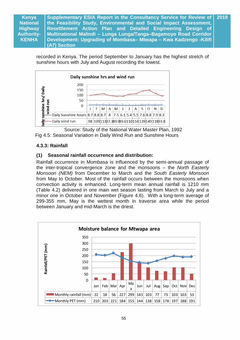
Kenya National Highway
Authority-KENHA
Supplementary ESIA Report in the Consultancy Service for Review of the Feasibility Study, Environmental and Social Impact Assessment, Resettlement Action Plan and Detailed Engineering Design of Multinational Malindi – Lunga Lunga/Tanga–Bagamoyo Road Corridor Development: Upgrading of Mombasa– Mtwapa – Kwa Kadzengo -Kilifi (A7) Section
2019
55
recorded in Kenya. The period September to January has the highest stretch of sunshine hours with July and August recording the lowest.
Source: Study of the National Water Master Plan, 1992
Fig 4.5: Seasonal Variation in Daily Wind Run and Sunshine Hours
4.3.3: Rainfall
(1) Seasonal rainfall occurrence and distribution:
Rainfall occurrence in Mombasa is influenced by the semi-annual passage of the inter-tropical convergence zone and the monsoons – the North Easterly Monsoon (NEM) from December to March and the South Easterly Monsoon from May to October. Most of the rainfall occurs between the monsoons when convection activity is enhanced. Long-term mean annual rainfall is 1210 mm (Table 4.2) delivered in one main wet season lasting from March to July and a minor one in October and November (Figure 4.6). With a long-term average of 299-355 mm, May is the wettest month in traverse area while the period between January and mid-March is the driest.
Jan Feb Mar AprMay
Jun Jul Aug Sep Oct Nov Dec
Monthly rainfall (mm) 22 18 56 227 299 143 103 77 73 103 103 53
Monthly PET (mm) 210 203 221 184 155 144 138 158 178 197 188 191
0
50
100
150
200
250
300
350
Rai
nfa
ll/P
ET (
mm
)
Moisture balance for Mtwapa area

Kenya National Highway
Authority-KENHA
Supplementary ESIA Report in the Consultancy Service for Review of the Feasibility Study, Environmental and Social Impact Assessment, Resettlement Action Plan and Detailed Engineering Design of Multinational Malindi – Lunga Lunga/Tanga–Bagamoyo Road Corridor Development: Upgrading of Mombasa– Mtwapa – Kwa Kadzengo -Kilifi (A7) Section
2019
56
Source: Ralph and Jaetzhold, 2006 Fig 4.6 (a): Seasonal Moisture Balance for the Mtwapa Area
Source: Walters Peter, 1988 Fig 4.6 (b): Seasonal Moisture Balance for the Bamburi Area
(2) Climatic potential of rainfall
This provides an analysis of the seasonal moisture balance for the Mombasa area based on comparison of balance between the long-term monthly rainfall catch and the potential evaporative demand. Annual potential evaporation in Mombasa averages 2167 mm (Table 4.2) while annual rainfall averages 1210 mm. From Fig 4.6, it is apparent that rainfall substantially exceeds potential evaporative demand in May and thus creates a positive moisture regime which is favourable for both ecological productivity and groundwater recharge; however, this can generate runoff and wreak havoc on infrastructure unless properly harnessed. The climatic value of rainfall in the traverse has been analysed based on computation of the climatic index as determined by the ratio of rainfall (r) to potential evapo-transpiration (Eo) based on the method of Sombroek et. al, 1982.4 With an r/Eo ratio of 0.56-0.59, the long-term climate of the traverse area
4

Kenya National Highway
Authority-KENHA
Supplementary ESIA Report in the Consultancy Service for Review of the Feasibility Study, Environmental and Social Impact Assessment, Resettlement Action Plan and Detailed Engineering Design of Multinational Malindi – Lunga Lunga/Tanga–Bagamoyo Road Corridor Development: Upgrading of Mombasa– Mtwapa – Kwa Kadzengo -Kilifi (A7) Section
2019
57
is apparently semi-humid but seasonally ranges from very arid in January and February to very humid in April and May. Such a high variability poses severe challenges in terms of vegetation development and semi-deciduous vegetation adapted to cope with seasonal moisture scarcity dominates the area. A seasonal moisture scarcity building from June to February imposes major limitation to rain-fed crop production and, as will appear in sections below, majority of the traverse area is food insecure on account of poor crop yield associated with inadequacy of soil moisture.

Kenya National Highway
Authority-KENHA
Supplementary ESIA Report in the Consultancy Service for Review of the Feasibility Study, Environmental and Social Impact Assessment, Resettlement Action Plan and Detailed Engineering Design of Multinational Malindi – Lunga Lunga/Tanga–Bagamoyo Road Corridor Development: Upgrading of Mombasa– Mtwapa – Kwa Kadzengo -Kilifi (A7) Section
2019
58
CHAPTER FIVE: EMPIRICAL CHARACTERIZATION OF THE BASELINE ENVIRONMENT Characterization of the pre-project baseline for the Mombasa-Mtwapa-Kwa Kadzengo-Kilifi Road Section employed both secondary data (as reported above) and empirical data procured through stand-alone studies. Four studies were commissioned as part of this ESIA study namely:-
Ambient air quality Noise and vibration levels Water quality of surface water and groundwater Biodiversity (Flora and Fauna) mapping
Findings from these surveys were further applied in characterizing the pre-project baseline scenario as unveiled in sections below.
5.1: AIR QUALITY AND NOISE MONITORING SURVEYS
5.1.1: Objectives of the Air Quality Survey
The objective of the environmental (ambient air quality and noise) survey is to investigate and document the pre-project status of ambient air quality and noise level in the traverse for the upgrading of the proposed Road Project. Accruing data provided a useful datum for future monitoring and reference.
5.1.2: Scope of survey
Parameters: The air quality and noise monitoring survey focused on monitoring 8 parameters (Table 5.1) entailing 6 pollutants (PM10, NOx, Sox, O3, CO, Pb) and 2 meteorological factors namely wind speed and direction.
Monitoring sites: Air Monitoring data is available for two sites namely Bamburi and Kwa Kadzengo both falling along the alignment for the A7 Highway section targeted for upgrading. Geographic details for each site including location are provided in Table 5.1 and Fig 5.1 below.
Table 5.1: Ambient Air Quality Survey Specification
Parameters Particulate Matter (PM10), Nitrogen Oxides (NOX), Sulphur Oxides (SOX), Carbon Monoxide (CO), Ozone (O3), Lead (Pb) and wind direction and wind speed
Survey location:
Bamburi Kwa Kadzengo
S -3.996091 E 39.730285
S -3.897204 E 39.771564
El (m): 11 18
Survey method Continuous measurement with air sampler
Period/schedule 24 hours x 1 day (September 2018)
Prediction method
Air pollutant levels are predicted by the plume model based on the increase of traffic emission.

Kenya National Highway
Authority-KENHA
Supplementary ESIA Report in the Consultancy Service for Review of the Feasibility Study, Environmental and Social Impact Assessment, Resettlement Action Plan and Detailed Engineering Design of Multinational Malindi – Lunga Lunga/Tanga–Bagamoyo Road Corridor Development: Upgrading of Mombasa– Mtwapa – Kwa Kadzengo -Kilifi (A7) Section
2019
59
Source: This study
5.1.3: Methods in measurements
Air sampling: Air sampling basically targeted to generate baseline data on atmospheric air quality. Field extraction of samples including direct monitoring of meteorological parameters was entrusted to the SGS whose staff undertook all the field work under supervision of the EIA Lead Expert. Air samples were extracted at roughly 2 metres above ground level.
Air samples were collected using an electric generator driven suction pump whose flow rate was calibrated to 3.46 litres per minute. The air was scrubbed through appropriate trapping solutions for sulphur dioxide, nitrogen dioxide, lead and ozone for periods of 15 minutes per sample. Sulphur dioxide was trapped in jars containing sodium-tetra-chloro-merculate solution while Carbon monoxide was trapped in silica impregnated with ammonium molybdinate. Nitrogen dioxide was trapped in tri-ethanolamine solution while lead was trapped in dilute sulphuric acid and preserved in nitric acid. Ozone was trapped in potassium iodide solution while suitable pre-weighed and pre-conditioned membrane filters were used to trap inhalable particulate matter (PM10).
Wind Measurement: Wind speed and direction were measured with a portable anemometer mounted at 1.5 m height above ground.
Laboratory analysis: All sample bottles were maintained in airtight conditions to prevent leakage or contamination. Once in the laboratory, analysis applied standard procedure summarized in Table 5.7 below. Data accruing was analysed against set standards either as recommended by NEMA and the WHO following which, this write-up was prepared.
Table 5.2: Laboratory analysis methods
Parameter Measurement methods Detection Limits Authority
Sulphur dioxide Pararosaniline method 0.2 -6.6 μg/m3 NAAQS1
Nitrogen dioxide Modified Griess-Saltzman method
4 to 10,000 µg/m3 (0.002 to 5 ppm (v)
ASTM2 D1607 -91 (2011)
Particulate matter (PM10)
The Filtration Technique 0.01-0.25 mg/m3 NAAQS
Carbon Monoxide
Spectrophotometric method
0-100 ppm NAAQS
Lead Atomic Absorption Spectrophotometry
1.05 μg/m3 VDI3 2267 (12): 2008
Ozone Spectrophotometric methods
10 μg/m3 VDI 2468 (4)
(1) National Ambient Air Quality Standards (NAAQS): www.epa.gov/air/criteria

Kenya National Highway
Authority-KENHA
Supplementary ESIA Report in the Consultancy Service for Review of the Feasibility Study, Environmental and Social Impact Assessment, Resettlement Action Plan and Detailed Engineering Design of Multinational Malindi – Lunga Lunga/Tanga–Bagamoyo Road Corridor Development: Upgrading of Mombasa– Mtwapa – Kwa Kadzengo -Kilifi (A7) Section
2019
60
(2) ASTM (American Society for Testing and Materials) Standard Test Method for Nitrogen Dioxide Content of the Atmosphere (Griess-Saltzman Reaction): www.astm.org/Standards/D1607 (3)VDI (Verein Deutscher Ingenieure-The Association of German Engineers) Guidelines: www.vdi.de; www.umweltbundesamt.de/luft/messeinrichtungen/4Appendix2.pdf
5.1.4: Findings of the Study
(a) Overview A detailed description of the outcome of laboratory analysis is available in Appendix 5.1. In this section, an overview of the core observations is provided based on which, monitoring of future impacts of the project on ambient air quality has been modelled. Data for the 5 sites is summarized in Table 5.3 and has also been compared with the tolerance limits specified either by NEMA or the World Health Organization. Units of measure for the standards are either in milligrams per cubic meter (mg/m3) and micrograms per cubic meter of air (µg/m3) respectively. Brief comments on the prevalence of each of the criteria parameters are provided below. Table 5.3: Result of Ambient Air Quality Survey
Pollutant Unit Location Kenya* WHO** Time weighted
average Bamburi Kwa
Kadzengo
Particulate matter
Pm10 g/m3 45 22 100 50 24 hours
50 20 1 Year
SOx (S02) g/m3 25 ND 80 20 24 Hours
60 500 10 min
NOx
(NO2) g/m3 16 ND 80 200 24 Hours
60 40 1 year
CO g/m3 788 560 4,000 30 (mg) 1 Hour
2,000 10 (mg) 8 Hours
03 g/m3 ND ND 0.12 NV 1 Hour
1.25 100 8 Hours
Lead g/m3 ND 3.8 1 NV 24 Hours
0.75 0.5 1 Year
Wind speed m/s 4 4 - - -
Wind direction - SW SE - - -
Source: ESIA Study for Mombasa Northern Bypass
Note: NV- No Value given; ND- Not detected (less than the quantification limits); *1: The Environmental Management and Coordination (Air Quality) Regulations, 2008 (Draft); *2: WHO Air Quality Guidelines for Particulate Matter, Ozone, Nitrogen Dioxide and Sulphur Dioxide, Global Update 2005

Kenya National Highway
Authority-KENHA
Supplementary ESIA Report in the Consultancy Service for Review of the Feasibility Study, Environmental and Social Impact Assessment, Resettlement Action Plan and Detailed Engineering Design of Multinational Malindi – Lunga Lunga/Tanga–Bagamoyo Road Corridor Development: Upgrading of Mombasa– Mtwapa – Kwa Kadzengo -Kilifi (A7) Section
2019
61
(b) Prevalence of pollutants
Of all the six pollutants monitored, only ozone was not detected5. Prevalence of other pollutants was recorded as follows:-
Particulate matter: Particulate matter (PM10)6 was detected in both Bamburi and Kadzengo sites but at concentrations way below both the Kenyan and WHO specifications for 24-hour exposure but exceed the WHO limit for 1 year.
Sulphur dioxide: Sulphur dioxide was detected at only one site, near Bamburi in concentrations that are below the Kenyan threshold but way above the WHO limit possibly on account of close proximity to the Cement manufacturer.
Carbon monoxide: Carbon monoxide was detected in both sites but at concentrations much lower than the Kenyan limit but way above the WHO thresholds for both 1 and 8 hours.
Nitrogen oxides (NOX): Of the 3 known oxides of nitrogen, only Nitrogen Dioxide was detected in the study area at Bamburi but at concentrations below both the WHO and Kenyan limits. It is acknowledged that the major sources of nitrogen dioxide are burning of fossil fuels which produce about 50% of all emissions from anthropogenic sources and the location of Bamburi near the Cement Manufacturer may explain the higher prevalence of NOx in the local air. This notwithstanding, levels of NO2 measured in Mombasa are apparently quite low as annual mean concentrations of nitrogen dioxide in urban areas throughout the world in the range of 20–90 μg/m3 have been reported (www.ifc.org). Maximum half-hour values and maximum 24- hour values of nitrogen dioxide can approach 850 μg/m3 and 400 μg/m3, respectively while hourly averages near very busy roads often exceed 1,000 μg/m3. The 16 μg/m3 measured for Bamburi area is thus low by both international and Kenyan standards but requires focussed monitoring.
(c): Local trends in airborne pollutants
In the Environmental Review for the Kipevu 2 Power Plant (http://www.worldbank.org/html/pic/aboutinfo.html), the estimated background SO2 ambient levels for 24-hour maximum was 180 ug/m3 and therefore close to double the Kenyan guideline for 24 hr exposure and far above the WHO guideline. The NO2 24-hour average levels were estimated to be 50 ug/m3
5 Ground-level ozone also known as ‘bad ozone’ has no direct emission sources; it is entirely a secondary pollutant,
formed when nitrogen oxides and HC react in the presence of heat and sunlight (photochemical reactions in the atmosphere). These two pollutants are often referred to as ozone precursors. Ozone destroys the photo-chemical smog. Its impacts include: Irritation of the respiratory system leading to chest pain, coughing, anorexia, nausea and lung inflammation. Prolonged exposure can cause Permanent/chronic lung damage. 6 PM10 represents the particle mass that enters the respiratory tract and it includes both the coarse (particle size between 2.5 and 10µm) and fine particles, those below 2.5µm in size.

Kenya National Highway
Authority-KENHA
Supplementary ESIA Report in the Consultancy Service for Review of the Feasibility Study, Environmental and Social Impact Assessment, Resettlement Action Plan and Detailed Engineering Design of Multinational Malindi – Lunga Lunga/Tanga–Bagamoyo Road Corridor Development: Upgrading of Mombasa– Mtwapa – Kwa Kadzengo -Kilifi (A7) Section
2019
62
(background of 40 ug/m3, plus Kipevu I and II impacts of 10 ug/m3) with an annual equivalent of 12 ug/m3 (background of 10 ug/m3, plus Kipevu I and II impacts of 2 ug/m3) both of which are within both the Kenyan and WHO limits. Similar data were obtained from a study undertaken by the KMD in measurements at six Mombasa sites namely; Mwembe Tayari, Saba Saba, Kongowea, Likoni Ferry, Miritini and Digo road (Table 5.4). Indeed, from this data, it is apparent that PM10 levels for the six sites exceed the Kenyan and WHO limits for both 24 hr and annual exposures. Table 5.4: November 2008 records of Pm10 in Mombasa
Site PM 10 (µg/m3) Remarks
Mwembe Tayari 123 All exceed the Kenyan and WHO limits for 24 hrs and annual exposure Saba Saba 366
Kongowea 285
Likoni Ferry 339
Miritini 218
Digo Road 117
Source: Kenya Meteorological Department Urban Air Pollution Programme, www.unep.org/transport/pcfv/PDF/KenyaCleanFuels_Report.pdf

Kenya National Highway
Authority-KENHA
Supplementary ESIA Report in the Consultancy Service for Review of the Feasibility Study, Environmental and Social Impact Assessment, Resettlement Action Plan and Detailed Engineering Design of Multinational Malindi – Lunga Lunga/Tanga–Bagamoyo Road Corridor Development: Upgrading of Mombasa– Mtwapa – Kwa Kadzengo -Kilifi (A7) Section
2019
63
CHAPTER SIX: RESULTS OF THE FLORA AND FAUNA MAPPING SURVEY
6.1: OBJECTIVE OF THE FLORA AND FAUNA SURVEY
The objective of the survey was to facilitate understanding of the present status of protected fauna species in the vicinity of proposed Project Road. Accruing data would be used as baseline for future monitoring purposes. This required a study design targeting mapping for flora and fauna (marine and terrestrial) species based on pre-selected criteria as follows:-
General occurrence of fauna species
Protected species declared as endangered or threatened species under the Wildlife (Conservation and Management) Act;
Threatened species (grouped as EN, CR, VU) in the IUCN Red List; and
Avian species which may occur within the AEWA (Agreement on the Conservation of African-Eurasian Migratory Water birds) List
Locally important flora and fauna species for the livelihood of local residents
6.2: STUDY METHODOLOGY
The focal area of the survey is shown in Fig 6.1 below basically tracing the traverse of the Project Road but expanding to cover the area between Bamburi and Kwa Kadzengo hinterland.
Diverse methodologies were adopted in respect of the floral and fauna surveys. From the onset, this recognized the need for a study design allowing for aquatic and terrestrial mapping strategies and a study schedule was rolled out as follows:- (i) Literature survey: Both Tudor and Mtwapa Creeks and adjoining areas have been the subject of past mapping activities on account of which, information on the floral and faunal diversity is readily available. The purpose of the fauna and floral survey was to screen the project area for occurrence of biodiversity classified as endangered. (ii) Flora Surveys: The flora survey used an ex-post approach, and mainly a walk-over through the vegetation to establish community assemblies, principal floral components present, the floral history of the area, and presence of rare/threatened plant species. The survey was partly guided by topographic map sheets, past aerial photographs and information available in the public to make a thorough investigation along the alignment. In the field a sampling area within the alignment was selected, and its physiognomic vegetation type was described (location details). The general phyto-sociology of the locality was noted and the major floral components were recorded. A list of rare and threatened plant taxa based on IUCN Red list or local user perspectives was developed from the flora
Kenya National Highway
Authority-KENHA
Supplementary ESIA Report in the Consultancy Service for Review of the Feasibility Study, Environmental and Social Impact Assessment, Resettlement Action Plan and Detailed Engineering Design of Multinational Malindi – Lunga Lunga/Tanga–Bagamoyo Road Corridor Development: Upgrading of Mombasa– Mtwapa – Kwa Kadzengo -Kilifi (A7) Section
2019
64
listed in the area, and these species were highlighted for further discussion. On completion, a new location was chosen and the process repeated. This process continued with sampling areas representing their physiognomic vegetation types, even though some were close together.
Plant species that were difficult to identify in the field were collected as voucher specimens and were identified through cross reference at the NMK-CFCU Herbarium in Ukunda and Nairobi (East African Herbarium) which maintain floral data and specimens through the published Floras. Data components collected included; Vegetation types description, Species inventory for the area, GPS locations for sites of special interesting, Digital graphics (photographs), Rarity/threats of plant species at local, national and global perspective were considered, Historical trends of the vegetation communities was also considered where possible among others. (iii) Faunal Surveys: Diverse methodologies were adopted depending on the site targeted for investigations.
Herpetofauna: Herpetofauna survey was conducted using identification of habitats and microhabitats, literature survey, among others. Sampling of the reptiles and amphibians was conducted using standardized time limited search and with visual encounter and interviews with the local residents. Under the Timed Limited Searches, a 30 minute sampling period making up one time limited search (TLS) by two observers was carried out in different parts of the study site. Searches took place in all possible and amphibian micro-habitats such as wetlands, tree barks, under stones, decomposing logs, tree stumps, holes, shrubs, bushes including digging within loose soils, etc . Visual encounter surveys is non- standardized but was used for qualitative and semi-quantitative data mainly for presence or absence of species. The approach is important because it contributes immensely in inventory of species.
Interviews with local residents targeted accounts of the common reptiles and amphibian species normally encountered. Through their description and use of images of the animals in guides, the species were identified.
Bird survey: Survey was conducted very early in the morning between 6.30 to 8.30 am when birds are active. Physical observation was done to identify birds; binoculars were used to improve on sight. Bird calls was also handy in identification. A transect of approximately 1.5 km was used for surveying bird diversity in the study areas using both Point Count (PC) and Time Species Counts (TSC) methods with minor adoptions to suit rapid assessment.
Point counts (PCs): PCs were set at every 200m along 1km transect running along the Project Road. Variable that was recorded was cue i.e. observed or species heard calling. This method was used in grassland/bushland and open shrublands.

Kenya National Highway
Authority-KENHA
Supplementary ESIA Report in the Consultancy Service for Review of the Feasibility Study, Environmental and Social Impact Assessment, Resettlement Action Plan and Detailed Engineering Design of Multinational Malindi – Lunga Lunga/Tanga–Bagamoyo Road Corridor Development: Upgrading of Mombasa– Mtwapa – Kwa Kadzengo -Kilifi (A7) Section
2019
65
Timed species counts (TSCs): TSC was used because it is ideal for building complete species lists quickly. About 30 minutes TSC was conducted mainly in the forests. Sights and calls are used in the approach.
Vantage point observations: Vantage point observations were used in wetlands (e.g. estuaries) where the raised landscape around provide platform for wider view of the wetland.
Insect Pollinator Survey: The survey sites had various habitat types that provided options for sampling by habitat characteristics. Habitat characteristic included vegetable gardens, hedges, shrubs, bushes, agro-forests, woodlands. Sweep nets were used to catch butterflies and bees on flights. Canopy traps for trapping butterflies (Plate 6.3) were set high up in the tree canopies with baits of fermented bananas. Physical observation was also conducted for species that were not caught by the traps.
Aquatic Invertebrate: Efforts here were focused on marine crustaceans and molluscs. Observation was conducted along the shoreline that comprised of mangrove swamps, tidal and mud flats. In addition to this, catch landings were assessed to find out the diversity of species of commercial value.
Verbal accounts from local people: Various discussions were held with the local communities on the species diversity and their local value to the community for various taxa. Focused group discussion was employed in order to acquire further information from the local people.
Ethno-botanical surveys: Alongside the field inventory of fauna and flora species, communities within the reserve and immediate vicinity of the proposed Mombasa South bypass were polled for reliance and attitude towards biodiversity resources based on a questionnaire administered to 120 respondents. Appendix 6.1 provides a copy of the questionnaire administered while outcome of the socio-economic survey is summarized in chapter three below. Appendix 6.2 summarizes the main uses of floral diversity as occurs in the study area.
6.3: ANALYSIS OF CONSERVATION STATUS
6.3.1: Application of the IUCN Criteria
The search engine for the IUCN Red list of threatened species (Fig. 6.1) was used to determine conservation status of the species. There are different categories of conservation status of species and are described in the IUCN red list data.7 These categories include Extinct, Extinct in the Wild, Critically
7 According to the IUCN Red List, a species is EXTINCT (EX) when there is no reasonable doubt that the
last individual has died, or; EXTINCT IN THE WILD (EW) when it is extinct in the wild and it is known only to survive in cultivation, in captivity or as a naturalized population (or populations) well outside the past range; CRITICALLY ENDANGERED (CR) when it is facing an extremely high risk of extinction in the wild in the immediate future, as defined by any of the criteria (A to E in the IUCN Red List Categories); ENDANGERED

Kenya National Highway
Authority-KENHA
Supplementary ESIA Report in the Consultancy Service for Review of the Feasibility Study, Environmental and Social Impact Assessment, Resettlement Action Plan and Detailed Engineering Design of Multinational Malindi – Lunga Lunga/Tanga–Bagamoyo Road Corridor Development: Upgrading of Mombasa– Mtwapa – Kwa Kadzengo -Kilifi (A7) Section
2019
66
Endangered, Endangered, Vulnerable, Lower Risk, Data Deficient and Not Evaluated. Names of species were entered in the IUCN Red list search engine for verification.
Fig. 6.1: Search engine for the IUCN Red list of threatened species
A species is DATA DEFICIENT (DD) when there is inadequate information to make a direct, or indirect, assessment of its risk of extinction based on its distribution and/or population status. Lastly, a species is NOT EVALUATED (NE) when it is has not yet been assessed against the criteria.
6.3.2: Requirements of the Convention on Migratory Species of Wild Animals
The Bonn Convention is a non-governmental treaty concluded under the aegis of the United Nations Environment Programme, and aims to conserve terrestrial, aquatic and avian migratory species throughout their range of habitats on a
(EN) when it is not Critically Endangered but is facing a very high risk of extinction in the wild in the near future, as defined by any of the criteria (A to E in the IUCN Red List Categories); VULNERABLE (VU) when it is not Critically Endangered or Endangered but is facing a high risk of extinction in the wild in the medium-term future, as defined by any of the criteria (A to E in the IUCN Red List Categories), and; LOWER RISK (LR) when it has been evaluated, does not satisfy the criteria for any of the categories Critically Endangered, Endangered or Vulnerable. Species included in the Lower Risk category are separated into three subcategories:
i. Conservation Dependent (CD): Taxa which are the focus of a continuing taxon-specific or habitat-specific conservation programme targeted towards the taxon in question, the cessation of which would result in the taxon qualifying for one of the threatened categories above within a period of five years.
ii. Near Threatened (NT): Taxa which do not qualify for Conservation Dependent, but which are close to qualifying for Vulnerable.
iii. Least Concern (LC): Taxa which do not qualify for Conservation Dependent or Near Threatened.
Kenya National Highway
Authority-KENHA
Supplementary ESIA Report in the Consultancy Service for Review of the Feasibility Study, Environmental and Social Impact Assessment, Resettlement Action Plan and Detailed Engineering Design of Multinational Malindi – Lunga Lunga/Tanga–Bagamoyo Road Corridor Development: Upgrading of Mombasa– Mtwapa – Kwa Kadzengo -Kilifi (A7) Section
2019
67
global scale. Since the Convention's entry into force, its membership has grown steadily to include 116 (as of 1 July 2011) Parties from Africa, Central and South America, Asia, Europe and Oceania. Kenya became a party to this convention in May 1999.
As the only global convention specializing in the conservation of migratory species, their habitats and migration routes, CMS complements and co-operates with a number of other international organizations, NGOs and partners in the media as well as in the corporate sector. Migratory species threatened with extinction are listed on Appendix I of the Convention. CMS Parties strive towards strictly protecting these animals, conserving or restoring the places where they live, mitigating obstacles to migration and controlling other factors that might endanger them. Besides establishing obligations for each State joining the Convention, CMS promotes concerted action among the Range States of many of these species.
Migratory species that need or would significantly benefit from international co-operation are listed in Appendix II of the Convention of which, Kenya is identified as a Range State for 44 of these. In this respect, CMS acts as a Framework Convention. The Agreements may range from legally binding treaties (called Agreements) to less formal instruments, such as Memoranda of Understanding, and can be adapted to the requirements of particular regions. Kenya is a party to four MOUs namely; - AEWA African Eurasian Water Bird Agreement) Marine Turtles Africa MOU, Marine Turtles-IOSEA and the African Elephant MOU. Under the Bonn Convention, Kenya is recognised as a Range State for 50 bird species out of which 4 namely, the Ardoela idea, Larus saundersi, Hirundo atrocaerulea, Acrocephalus griseldis and Zoothera guttat are Bonn Convention Appendix 1 species. As part of the survey for flora and fauna, all birds occurring within the road transect were screened for occurrence in Appendix I& II of the Bonn Convention including Kenya Country Reports on the same.
6.3.3: The African-Eurasian Migratory Water-bird Agreement (AEWA)
This agreement was negotiated under the provisions of Article IV of the Bonn Convention and concluded on 16 June 1995 in The Hague, the Netherlands subsequently coming into force on 1 November 1999. The Aim of AEWA is to create a legal basis for concerted conservation and management policy by the Range States for migratory water bird species in pursuit of the mission to maintain migratory water bird species and their populations at a favourable conservation status or to restore them to such a status throughout their flyways, over a range of 118 countries.
6.3.4: Screening for local importance as per Kenyan Law
Conservation of biodiversity in Kenya basically vests under three laws namely:

Kenya National Highway
Authority-KENHA
Supplementary ESIA Report in the Consultancy Service for Review of the Feasibility Study, Environmental and Social Impact Assessment, Resettlement Action Plan and Detailed Engineering Design of Multinational Malindi – Lunga Lunga/Tanga–Bagamoyo Road Corridor Development: Upgrading of Mombasa– Mtwapa – Kwa Kadzengo -Kilifi (A7) Section
2019
68
The National Constitution
The Forests Management and Conservation Act 2016
The Environment Management Coordination Act (EMCA)
The Antiques and Monuments Act
The Wildlife Management and Conservation Act Flora and fauna recorded were screened against requirements of each tool. 6.4: FINDINGS ON THE CONSERVATION STATUS OF FLORAL BIODIVERSITY
6.4.1: Floral formations within the Traverse
Findings on floral biodiversity are presented at two levels namely; - occurrence of floral formations and conservation status of individual trees. The area investigated notably consisted of varied vegetation types that were physiognomically identifiable through vascular plant tree cover, dominant species and the floristic composition. Although some floral plants were generalists (found in more than one vegetation type) others-maintained presence only in given vegetation areas. The vegetation types were arbitrarily distributed through the entire alignment, in varied sizes that ranged from a few square meters to a couple of hectares. A generalized overview of the vegetation formations in close vicinity of the Bypass area is provided in Fig 6.3 below while a comprehensive botanical inventory is provided in Appendix 6.3. A total of 5 ecosystems/land use systems have been identified within close vicinity of the traverse for both Project Road as tabulated in Table 6.2 below based on which, an analysis of the floral and faunal diversity within the project area has been undertaken. Two (2) out of the five (5) ecosystems namely; - mangrove formations and sacred forests (Kaya Forests) are not directly traversed by the proposed roads but occur within significantly close vicinity which makes them vulnerable to activities in road construction and operation. Brief highlights on each ecosystem are provided in sections below. Table 6.1: Occurrence of ecosystems within the traverse
No. Classification of Ecosystem
Traverse of interest
1 Urban/peri-Urban ecosystems
The entire 20.8 Km traverse between Nyali Bridge and Kwa Kadzengo Junction with Proposed Mombasa Northern Bypass (MNB)
2 Bamburi Forest ecosystem Bamburi Haller Estate
3 Mangrove formations Small sections at Nyali and Mtwapa Creeks
4 Marshlands The Kwa Kadzengo area
5 Farmlands and bushlands Kwa Kadzengo to Kilifi 33.1Km

Kenya National Highway
Authority-KENHA
Supplementary ESIA Report in the Consultancy Service for Review of the Feasibility Study, Environmental and Social Impact Assessment, Resettlement Action Plan and Detailed Engineering Design of Multinational Malindi – Lunga Lunga/Tanga–Bagamoyo Road Corridor Development: Upgrading of Mombasa– Mtwapa – Kwa Kadzengo -Kilifi (A7) Section
2019
69
6.4.2: Floral diversity within the Traverse
Appendix 6.2 below provides the comprehensive inventory of floral biodiversity within
the traverse. A total of 123 plant species, mainly indigenous but also few exotics were
recorded within the traverse. Within Bamburi cement factory and Haller Park, 87 species
plant species were recorded with another 36 occurring in the riparian areas. Mangrove
species will also be found at the creek sides.
6.4.3: Mangrove and inter-tidal flats ecosystems
Occurrence: The Nyali-Mtwapa-Kwa Kadzengo Section of A7 Highway traverse catchments of two critically important intertidal creeks namely;- the Tudor and Mtwapa which, together with the Port Reitz Creek to the south form the Mombasa Creeks system comprised of sheltered inland lagoons which form the basis for centuries old marine commerce and trade. Tudor Creek: Tudor creek (Fig. 1) bounds Mombasa Island on the northwest and extends some 10 km inland. The creek has two main seasonal rivers, Kombeni and Tsalu, draining an area of 550 km2 (450 and 100 km2 respectively) with average freshwater discharge estimated at 0.9 m3 s-1 during the inter-monsoon long rains. Tudor has a single narrow sinuous inlet with a mean depth of 20 m, that broadens out further inland to a central relatively shallow basin (5 m) fringed by a well-developed mangrove forest where Riziphora mucronata (Rhizophoraceae), Avicenia marina (Avicenniaceae) and Sonneratia alba (Sonneratiaceae) are the dominant species. The basin has an area of 6.37 km2 at low water spring and 22.35 km2 at high water spring implying an inter-tidal zone of 16 km2 (1600ha) of which, as at 1992, 1465ha used to be under mangrove forest but which has drastically reduced to 216ha by 2009. This ecosystem interacts with the proposed road only at the Northern end of the Nyali Bridge. Mtwapa Creek: The creek is approximately 13.5km in length and opens to the Indian Ocean through a long narrow channel. It consists of three forest patches (Gung’ombe, Kitumbo and Kidongo: named after adjacent large villages) which are situated further landward from the mouth fed by three seasonal rivers (Kwa Ndovu, Kashani and Kidutani). As is the case with Tudor, Mtwapa mangroves are dominated by five species of which Rhizophora mucronata is the most abundant in terms of stem density and distribution followed by Avicennia marina and both species combined have a higher abundance than the other species. Sonneratia alba and Xylocarpus granatum are only encountered in Gung’ombe and Kitumbo with S. alba recording low densities in both forest patches. Ecology and economic importance: Both Mtwapa and Tudor Creeks are dominated by mangrove and inter-tidal flat ecosystems created and influenced by the extent and duration of saline inundation between the low and high tide cycle. On account of occupying shallow areas, mangrove formations trap silt, sediments

Kenya National Highway
Authority-KENHA
Supplementary ESIA Report in the Consultancy Service for Review of the Feasibility Study, Environmental and Social Impact Assessment, Resettlement Action Plan and Detailed Engineering Design of Multinational Malindi – Lunga Lunga/Tanga–Bagamoyo Road Corridor Development: Upgrading of Mombasa– Mtwapa – Kwa Kadzengo -Kilifi (A7) Section
2019
70
and accumulate litter which makes them very suitable breeding and foraging grounds supporting complex food chains and are marked by very high ecological productivity and species diversity. They are among some of the most productive and biologically important ecosystems of the world because they provide important and unique ecosystem goods and services to human society and coastal and marine systems (FAO 2007). The forests help stabilize shorelines and reduce the devastating impact of natural disasters such as tsunamis and hurricanes. They also provide breeding and nursing grounds for marine and pelagic species, and food, medicine, fuel and building materials for local communities (Giri et al. 2010). Mangroves, including associated soils, could sequester approximately 22.8 million metric tons of carbon each year. Covering only 0.1% of the earth’s continental surface, the forests account for 11% of the total input of terrestrial carbon into the ocean (Jennerjahn & Ittekot, 2002) and 10% of the terrestrial dissolved organic carbon (DOC) exported to the ocean (Dittmar et al., 2006). The rapid disappearance and degradation of mangroves could have negative consequences for transfer of materials into the marine systems and influence the atmospheric composition and climate. Mangroves support the conservation of biological diversity by providing habitats, spawning grounds, nurseries and nutrients for a number of animals. These include several endangered species and range from reptiles (e.g. crocodiles, iguanas and snakes) and amphibians to mammals and birds (herons, egrets, pelicans and eagles). A wide range of commercial and non-commercial fish and shellfish also depends on these coastal forests. Mangrove organic productivity (Odum and Heald, 1972) has been suggested to support near shore fisheries production (Lee, 1999). Mangrove ecosystems are also used for aquaculture, both as open-water estuarine mariculture (e.g. oysters and mussels) and as pond culture (mainly for shrimps). At the Kenyan coast, mangrove forests are exploited for timber, fuel wood, poles, fodder and fisheries resources by 70% of the population living in the Kenyan coastal villages.
6.4.4: The Bamburi Forest Ecosystem
History: Bamburi Forest is an artificial ecosystem created out of quarry spoils previously exploited to below sea level in the mining of limestone for cement manufacture by Bamburi Cement Ltd. The Bamburi cement factory opened four years after feasibility studies in 1954. The factory raw materials are mainly Pleistocene coral limestone and Jurassic shale clay, which were exposed when the sea receded some 130 - 200 million years ago. Quarrying for raw materials is done up to 30 and 50 cm above groundwater level. The resulting ground water in the quarry is saline and connected to the Indian Ocean aquifer through the porous coral rock layer that is below. This created a sterile and inhospitable wasteland. From its inception, the resulting open quarry pits were a source of concern for the cement factory management because of the damage they were

Kenya National Highway
Authority-KENHA
Supplementary ESIA Report in the Consultancy Service for Review of the Feasibility Study, Environmental and Social Impact Assessment, Resettlement Action Plan and Detailed Engineering Design of Multinational Malindi – Lunga Lunga/Tanga–Bagamoyo Road Corridor Development: Upgrading of Mombasa– Mtwapa – Kwa Kadzengo -Kilifi (A7) Section
2019
71
causing. Land reclamation started in 1971, by initially planting 26 tree species in open quarries. After six months, only three species; - Casuarina equisetifolia, Conocarpus lancifolius and coconut had survived. Casuarina sp. was identified as a better pioneer because it can tolerate saline water despite being adapted to dry conditions, it can fix atmospheric nitrogen in the root system and is an evergreen tree which constantly drops and renews foliage; and it grows fast, reaching 2m in six months. The Casuarina tree or ‘Whistling Pine’, originated from Australia, but is now a common tree along the East African coast has leaves with high tannin content which makes their decomposition by micro-organisms difficult. In order to contain the problem, the locally common Red-legged Millipede, Epibolus pulchripes which feeds on the Casuarina needles was introduced. Once the Casuarina needles have passed through the millipede gut, micro-organisms can convert the droppings into humus and within 30 years a humus layer 10-12 cm thick has developed with the help of the millipedes. In the humus layer, other species of plants can germinate and grow, a first step in the development from a Casuarina monoculture towards a diverse forest.

Kenya National Highway
Authority-KENHA
Supplementary ESIA Report in the Consultancy Service for Review of the Feasibility Study, Environmental and Social Impact Assessment, Resettlement Action Plan and Detailed Engineering Design of Multinational Malindi – Lunga Lunga/Tanga–Bagamoyo Road Corridor Development: Upgrading of Mombasa– Mtwapa – Kwa Kadzengo -Kilifi (A7) Section
2019
72
Fig 6.7: An artificially created ecosystem at Haller Park Current Status: The Haller Forests comprises of 400 hectares of a mixture of plantation and mixed species which serve as Forest Trails and recreation facilities. As the quarrying expands, eventually these green areas will grow further still. The oldest part of Haller Park now shows a mix of trees, as the non-indigenous Casuarina had prepared the ground and conducive environment to plant local species of trees, a process gradually introduced to the areas more recently rehabilitated, as and when there is enough humus on the bare rock floors to actually sustain seeding, rooting and growth.
6.4.6: Riparian Vegetation
At Km 20.8 is the dominant riparian ecosystem along the traverse which is occasioned by the seasonal Kwa Kadzengo wetland. As will appear in sections below, this wetland is an important habitat for birds, five of which are internationally listed.

Kenya National Highway
Authority-KENHA
Supplementary ESIA Report in the Consultancy Service for Review of the Feasibility Study, Environmental and Social Impact Assessment, Resettlement Action Plan and Detailed Engineering Design of Multinational Malindi – Lunga Lunga/Tanga–Bagamoyo Road Corridor Development: Upgrading of Mombasa– Mtwapa – Kwa Kadzengo -Kilifi (A7) Section
2019
73
Plate 6.1: The Kwa Kadzengo swamp
6.5: STATUS OF CONSERVATION OF FAUNA BIODIVERSITY
This section outlines core findings on the fauna survey. Given the wide spectrum of faunal biodiversity occurring in coastal Kenya, some criteria were applied in selecting some animal species and not others. Brief overviews are provided under relevant headings below.
6.5.1: Mammals
None of habitats traverse was found to harbour mammals under natural conditions. Instead mammalian species namely Eland, small bucks (bushbuck, duiker, suni), genet and civet cats, mongoose, giant rats, squirrels, hares, monkeys, bush babies etc have taken refuge in the Bamburi Forest where they found a safe and secure habitat to escape pressure associated with urbanization of surrounding woodlands. On their part, Kaya forests were found to harbour animals such as the Bush Baby (Diani dwarf Gallagos), Wild pigs and Vervet Monkey. This implies that mammals will only be encountered in forested habitats along the traverse.
6.5.2: Conservation status for Avian fauna-Birds
Total bird count: Appendix 6.4 provides a list of all birds recorded within the traverse of the Project Road based on a bird survey conducted continuously between 7th and 20th January 2019. A total of 81 bird species were recorded in diverse habitats traversed with the highest count of 41 birds being recorded around the Kwa Kadzengo marshlands.
Conservation status: A total of 81-bird species were counted within the traverse area. All the 81 avian species recorded were screened for conservation

Kenya National Highway
Authority-KENHA
Supplementary ESIA Report in the Consultancy Service for Review of the Feasibility Study, Environmental and Social Impact Assessment, Resettlement Action Plan and Detailed Engineering Design of Multinational Malindi – Lunga Lunga/Tanga–Bagamoyo Road Corridor Development: Upgrading of Mombasa– Mtwapa – Kwa Kadzengo -Kilifi (A7) Section
2019
74
status against the IUCN RED LIST data and AEWA checklist with outcome that 8 birds are of concern. Three bird species namely;- the Gray Parrot, Fisher’s Lovebird and Wooly necked Stork feature in the IUCN RED List Data (Table 6.4) on account of being Endangered, Near Threatened and Vulnerable while 5 species namely;- the Zanzibar Somber Greenbul, Cattle Egret, Grey Heron, Sacred Ibis and the Three-banded Plover are listed in the AEWA (Agreement on the Conservation of African-Eurasian Migratory Water Birds). All the AEWA species are found in the seasonal Kwa Kadzengo marshland (WL) habitat which makes this marsh and surrounding farmland very important habitat for migratory water birds.
Table 6.4: Screening of bird species for conservation status
Common name Scientific name Habitat IUCN Red List
AEWA
1. Grey parrot Psittacus erithacus FL Endangered
2. Fischer's loverbird Agapornis fischeri FL Near Threatened
3. Woolly-necked Stork Ciconia episcopus WL Vulnerable
4. Zanzibar Somber Greenbul
Andropaclus importunes
F ND AEWA
5. Wood Sandpiper Tringa glareola WL LC AEWA, CMS
6. Black-headed Heron Ardea melanocephala FL/WL LC AEWA
7. Grey Heron Ardea cinerea WL LC AEWA
8. Sacred Ibis Threskiornis aethiopicus
WL LC AEWA, CMS
Key: FL=Farmland; F=Forest; WL=Wetland

Kenya National Highway
Authority-KENHA
Supplementary ESIA Report in the Consultancy Service for Review of the Feasibility Study, Environmental and Social Impact Assessment, Resettlement Action Plan and Detailed Engineering Design of Multinational Malindi – Lunga Lunga/Tanga–Bagamoyo Road Corridor Development: Upgrading of Mombasa– Mtwapa – Kwa Kadzengo -Kilifi (A7) Section
2019
75
CHAPTER SEVEN: THE SOCIAL ECONOMIC PROFILE
7.1: OVERVIEW OF THE SURVEY
The purpose of the socio-economic survey was to facilitate documentation of the baseline characteristics of the individuals along the traverse but was also used to facilitate social stratification of the potentially affected people and to document social features including wellbeing and levels of vulnerability.
7.1.1: Administrative profile
The Mombasa-Mtwapa-Kwa Kadzengo - Kilifi Road Project traverses 3 sub counties of Nyali, Kisauni and Bahari within Mombasa and Kilifi Counties.
7.1.2: The People
Though coastal Kenya is original dominated by the Miji Kenda Community, the situation along the A7 is long changed with the settlement of new people to give a cosmopolitan mix.
7.2: OUTCOME OF THE SOCIO-ECONOMIC SURVEY
7.2.1: Approach to the Socio-economic survey Broad Approach: Socio-economic analysis for the Mombasa – Mtwapa – Kwa Kadzengo - Kilifi Road Project was approached from diverse angle including Public consultations (Chapter Eight), Gender Mapping Study (Stand alone Report), Census Survey for RAP (Stand alone RAP Report), and from a questionnaire survey administered on 31.4% of all potential PAPs. The social statistics unveiled here are largely borrowed from the latter study. Sample composition: A total of 480 respondents representing the four (4) PAP categories were reached as documented in Table 7.1 below. With the exception of employees, the sample represented between 29 to 35% of each PAP category. Table 7.1: Stratification of sample by PAP Category
PAP Category Total tally Share (%) Sample size Representation (%)
Property owners 618 40.4 204 33.0
Residential tenants
221 14.4 64 29.0
Business tenants 572 37.4 200 35.0
Employees 120 7.8 12 10.0
Total 1531 100 480 31.4
Source: This study

Kenya National Highway
Authority-KENHA
Supplementary ESIA Report in the Consultancy Service for Review of the Feasibility Study, Environmental and Social Impact Assessment, Resettlement Action Plan and Detailed Engineering Design of Multinational Malindi – Lunga Lunga/Tanga–Bagamoyo Road Corridor Development: Upgrading of Mombasa– Mtwapa – Kwa Kadzengo -Kilifi (A7) Section
2019
76
For ease of treatment, all property owners have been lumped together in this study. However, in reality, each category has diverse sub-groupings. We provide a breakdown of the Property Owner Category which has impact on certain dimensions especially on status of income and well-being. The 204 property owners sampled represent 5 sub-categories comprising land owners, structure owners, land and structure owners, land/structure and business owners and structure and business owners. Respondents who combine ownership of structures and the land on which they stand are the majority at 62 followed by those owning only land at 46. As discussed later, this structure has great impact on status of well-being. 7.2.3: Geographic spread In line with the prior observed trend whereby Mombasa accounts for the highest number of PAPs, the sample for socio-economic survey displayed a similar trend. While actual composition varied with PAP categories, in general, 75% of respondents were picked from Mombasa County with rest coming from Kilifi County.
Source: This Study Fig 7.1: Geographic spread of respondents in the socio-economic survey 7.2.4: Age patterns among potentially affected population General pattern: All participants in the socio-economic survey were of 20 years and above and were physically present in the traverse area during the questionnaire survey. For ease of analysis, respondents have been lumped into 6 age sets ranging from 20 to over 70 years. The age category of 31 to 40 years emerged dominant (Fig 7.2) followed by the 41 to 50 years category implying that, the bulk of respondents, and by extension residents of the traverse, are aged 30-50 years. 352 (74%) respondents are aged below 50 years and are within productive age group and the project area will be potential labour pool during project construction.

Kenya National Highway
Authority-KENHA
Supplementary ESIA Report in the Consultancy Service for Review of the Feasibility Study, Environmental and Social Impact Assessment, Resettlement Action Plan and Detailed Engineering Design of Multinational Malindi – Lunga Lunga/Tanga–Bagamoyo Road Corridor Development: Upgrading of Mombasa– Mtwapa – Kwa Kadzengo -Kilifi (A7) Section
2019
77
Source: This study Fig 7.2: Age structure for participants in the socio-economic survey Patterns among PAP categories: Age dynamics vary greatly among PAP categories (Fig 7.3). Residential and Business Tenants form majority of the youthful population of 40years and below. Beyond 30 years age set however, the population of both categories declines sharply and is near absent at age 60years. Beyond this age, both categories have either relocated or become property owners. Population of property owners is quite low within the youthful age categories but rises steadily to peak at age 40 years beyond which, it is both the dominant and actually only category feasible in the traverse area. This is reflective of the Kenyan pattern of economic progression whereby, individuals endeavour to save earnings and acquire property and economic stability with age.
Source: This study Fig 7.3: Age structure among PAP Categories 7.2.5: Gender stratification of respondents Table 7.2 below shows gender composition in PAP Categories. The male gender is overall dominant at 58.9% of sample and also leads all categories with the exception of Residential Tenants. The latter is probably in keeping with the
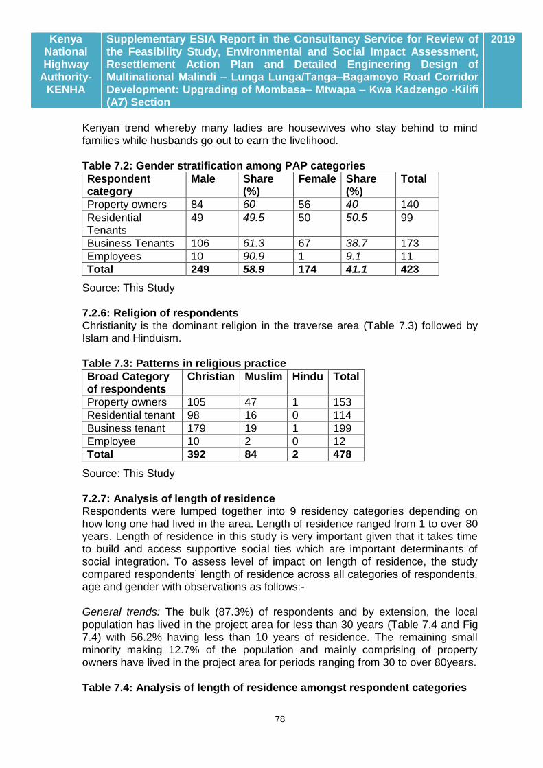
Kenya National Highway
Authority-KENHA
Supplementary ESIA Report in the Consultancy Service for Review of the Feasibility Study, Environmental and Social Impact Assessment, Resettlement Action Plan and Detailed Engineering Design of Multinational Malindi – Lunga Lunga/Tanga–Bagamoyo Road Corridor Development: Upgrading of Mombasa– Mtwapa – Kwa Kadzengo -Kilifi (A7) Section
2019
78
Kenyan trend whereby many ladies are housewives who stay behind to mind families while husbands go out to earn the livelihood. Table 7.2: Gender stratification among PAP categories
Respondent category
Male Share (%)
Female Share (%)
Total
Property owners 84 60 56 40 140
Residential Tenants
49 49.5 50 50.5 99
Business Tenants 106 61.3 67 38.7 173
Employees 10 90.9 1 9.1 11
Total 249 58.9 174 41.1 423
Source: This Study 7.2.6: Religion of respondents Christianity is the dominant religion in the traverse area (Table 7.3) followed by Islam and Hinduism. Table 7.3: Patterns in religious practice
Broad Category of respondents
Christian Muslim Hindu Total
Property owners 105 47 1 153
Residential tenant 98 16 0 114
Business tenant 179 19 1 199
Employee 10 2 0 12
Total 392 84 2 478
Source: This Study 7.2.7: Analysis of length of residence Respondents were lumped together into 9 residency categories depending on how long one had lived in the area. Length of residence ranged from 1 to over 80 years. Length of residence in this study is very important given that it takes time to build and access supportive social ties which are important determinants of social integration. To assess level of impact on length of residence, the study compared respondents’ length of residence across all categories of respondents, age and gender with observations as follows:- General trends: The bulk (87.3%) of respondents and by extension, the local population has lived in the project area for less than 30 years (Table 7.4 and Fig 7.4) with 56.2% having less than 10 years of residence. The remaining small minority making 12.7% of the population and mainly comprising of property owners have lived in the project area for periods ranging from 30 to over 80years. Table 7.4: Analysis of length of residence amongst respondent categories

Kenya National Highway
Authority-KENHA
Supplementary ESIA Report in the Consultancy Service for Review of the Feasibility Study, Environmental and Social Impact Assessment, Resettlement Action Plan and Detailed Engineering Design of Multinational Malindi – Lunga Lunga/Tanga–Bagamoyo Road Corridor Development: Upgrading of Mombasa– Mtwapa – Kwa Kadzengo -Kilifi (A7) Section
2019
79
Respondent category
Length of residence (years) Tally
1-10 11-20 21-30 31-40 41-50 51-60 61-70 >70
Property owners
34 27 40 25 13 6 4 5 154
Residential tenants
84 20 4 4 2 114
Business tenants
143 48 7 2 200
Employees 8 2 1 1 12
Total 269 97 52 31 14 8 4 4 479
Share (%) 56.2 20.3 10.9 6.5 2.9 1.7 0.8 0.8 100.0
Source: This Study Trends specific to PAP categories: Fig 7.4 presents a graphic analysis of length of residence among PAP categories. Tenant PAPs form the majority in the 1-20 yeas residence category but drop drastically after 15 years. None of the tenants has lived in the area for more than 25 years. On the contrary, property owners show a low but consistent and prolonged pattern of residence and are the only visible group beyond the 50 years mark which, as observed elsewhere above possibly points to ancestral land ownership. Indeed, the fact that Kilifi County dominates for residence periods in excess of 50 years (see inset) is indicative of ancestral land ownership.
Source: This Study Fig 7.4: Analysis of length of residence amongst respondent categories 7.2.8: Household characteristics Head of Household: The question on composition of households attracted only 409 respondents probably implying that some respondents are single and outside
From 1-10Yrs
From 11-20Yrs
From 31-40Yrs
From 41-50Yrs
From 51-60Yrs
From 61-70Yrs
> 70 Yrs
Mombasa 200 80 22 10 2 1 2
Kilifi 69 17 9 4 6 3 3
1
2
4
8
16
32
64
128
256
Coun
t
Stratification of LR by County of traverse

Kenya National Highway
Authority-KENHA
Supplementary ESIA Report in the Consultancy Service for Review of the Feasibility Study, Environmental and Social Impact Assessment, Resettlement Action Plan and Detailed Engineering Design of Multinational Malindi – Lunga Lunga/Tanga–Bagamoyo Road Corridor Development: Upgrading of Mombasa– Mtwapa – Kwa Kadzengo -Kilifi (A7) Section
2019
80
of any kind of family set up. This notwithstanding, the male gender dominates among heads of households at 83.4% (Table 7.5) of total count. Table 7.5: Composition of Heads of Households
Respondent Category
MHH FHH Total
Property owners 108 19 127
Residential Tenants 82 17 99
Business Tenants 139 32 171
Employees 12 0 12
Totals 341 68 409
Share (%) 83.4 16.6 100
Source: This Study Key: MHH-Male Headed Households; FHH-Female Headed Households Mean household size: The mean household size across all PAP categories was observed to be 5.9 but ranges from 4.75 to 7.13. Mean which is slightly higher than the national average of 5. 9. Household size seems variable for property owner sub-categories but is stable and near uniform for tenants and employees (Fig 7.4).
Source: This study Fig 7.4: Analysis of household dynamics for respondent groups Education of attainment: Majority (94.7%) of the respondents have been to school (Fig 7.5) as only 5.4% reported having no formal training. As well, 67.3% of respondents are of secondary school education and above. Generally,
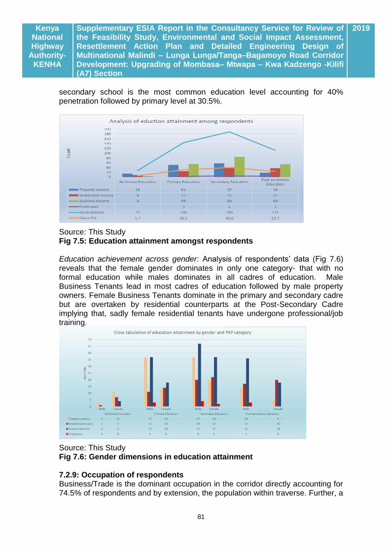
Kenya National Highway
Authority-KENHA
Supplementary ESIA Report in the Consultancy Service for Review of the Feasibility Study, Environmental and Social Impact Assessment, Resettlement Action Plan and Detailed Engineering Design of Multinational Malindi – Lunga Lunga/Tanga–Bagamoyo Road Corridor Development: Upgrading of Mombasa– Mtwapa – Kwa Kadzengo -Kilifi (A7) Section
2019
81
secondary school is the most common education level accounting for 40% penetration followed by primary level at 30.5%.
Source: This Study Fig 7.5: Education attainment amongst respondents Education achievement across gender: Analysis of respondents’ data (Fig 7.6) reveals that the female gender dominates in only one category- that with no formal education while males dominates in all cadres of education. Male Business Tenants lead in most cadres of education followed by male property owners. Female Business Tenants dominate in the primary and secondary cadre but are overtaken by residential counterparts at the Post-Secondary Cadre implying that, sadly female residential tenants have undergone professional/job training.
Source: This Study Fig 7.6: Gender dimensions in education attainment 7.2.9: Occupation of respondents Business/Trade is the dominant occupation in the corridor directly accounting for 74.5% of respondents and by extension, the population within traverse. Further, a
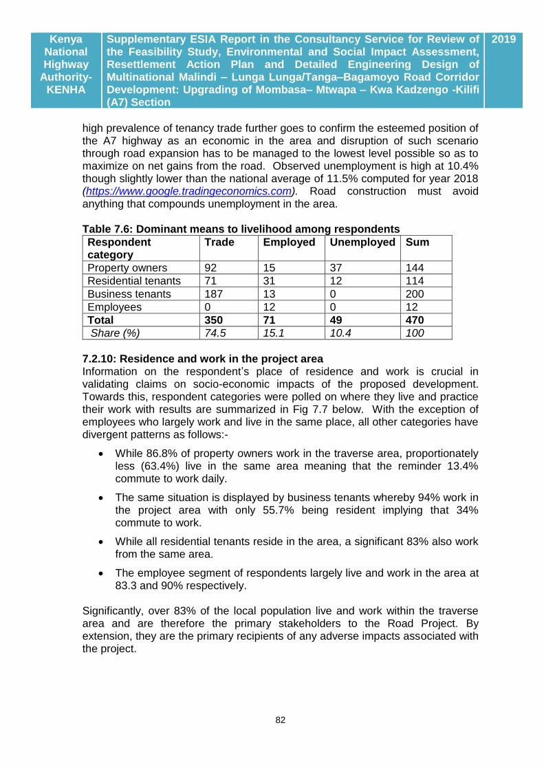
Kenya National Highway
Authority-KENHA
Supplementary ESIA Report in the Consultancy Service for Review of the Feasibility Study, Environmental and Social Impact Assessment, Resettlement Action Plan and Detailed Engineering Design of Multinational Malindi – Lunga Lunga/Tanga–Bagamoyo Road Corridor Development: Upgrading of Mombasa– Mtwapa – Kwa Kadzengo -Kilifi (A7) Section
2019
82
high prevalence of tenancy trade further goes to confirm the esteemed position of the A7 highway as an economic in the area and disruption of such scenario through road expansion has to be managed to the lowest level possible so as to maximize on net gains from the road. Observed unemployment is high at 10.4% though slightly lower than the national average of 11.5% computed for year 2018 (https://www.google.tradingeconomics.com). Road construction must avoid anything that compounds unemployment in the area. Table 7.6: Dominant means to livelihood among respondents
Respondent category
Trade Employed Unemployed Sum
Property owners 92 15 37 144
Residential tenants 71 31 12 114
Business tenants 187 13 0 200
Employees 0 12 0 12
Total 350 71 49 470
Share (%) 74.5 15.1 10.4 100
7.2.10: Residence and work in the project area Information on the respondent’s place of residence and work is crucial in validating claims on socio-economic impacts of the proposed development. Towards this, respondent categories were polled on where they live and practice their work with results are summarized in Fig 7.7 below. With the exception of employees who largely work and live in the same place, all other categories have divergent patterns as follows:-
While 86.8% of property owners work in the traverse area, proportionately less (63.4%) live in the same area meaning that the reminder 13.4% commute to work daily.
The same situation is displayed by business tenants whereby 94% work in the project area with only 55.7% being resident implying that 34% commute to work.
While all residential tenants reside in the area, a significant 83% also work from the same area.
The employee segment of respondents largely live and work in the area at 83.3 and 90% respectively.
Significantly, over 83% of the local population live and work within the traverse area and are therefore the primary stakeholders to the Road Project. By extension, they are the primary recipients of any adverse impacts associated with the project.
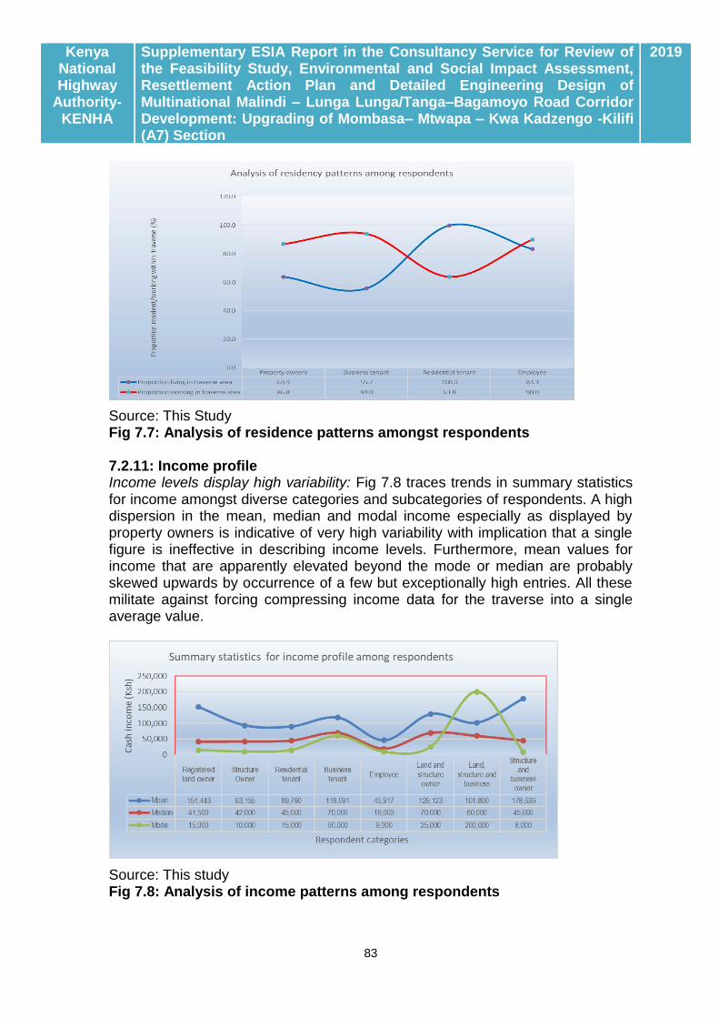
Kenya National Highway
Authority-KENHA
Supplementary ESIA Report in the Consultancy Service for Review of the Feasibility Study, Environmental and Social Impact Assessment, Resettlement Action Plan and Detailed Engineering Design of Multinational Malindi – Lunga Lunga/Tanga–Bagamoyo Road Corridor Development: Upgrading of Mombasa– Mtwapa – Kwa Kadzengo -Kilifi (A7) Section
2019
83
Source: This Study Fig 7.7: Analysis of residence patterns amongst respondents 7.2.11: Income profile Income levels display high variability: Fig 7.8 traces trends in summary statistics for income amongst diverse categories and subcategories of respondents. A high dispersion in the mean, median and modal income especially as displayed by property owners is indicative of very high variability with implication that a single figure is ineffective in describing income levels. Furthermore, mean values for income that are apparently elevated beyond the mode or median are probably skewed upwards by occurrence of a few but exceptionally high entries. All these militate against forcing compressing income data for the traverse into a single average value.
Source: This study Fig 7.8: Analysis of income patterns among respondents

Kenya National Highway
Authority-KENHA
Supplementary ESIA Report in the Consultancy Service for Review of the Feasibility Study, Environmental and Social Impact Assessment, Resettlement Action Plan and Detailed Engineering Design of Multinational Malindi – Lunga Lunga/Tanga–Bagamoyo Road Corridor Development: Upgrading of Mombasa– Mtwapa – Kwa Kadzengo -Kilifi (A7) Section
2019
84
Middle class earners dominate the traverse: For ease of treatment, respondents have been lumped into low, middle- and high-income categories based on the cut-offs applied by diverse authorities. The World Bank puts the middle-class individual’s or household’s daily income at between $10 and $50 (Sh1,031 and Sh5,158) per person per day which works out to an average income of Sh27,000 to Sh140,000 a month. The African Development Bank (AfDB) defines middle class as anyone who spends between $2 and $20 a day (Sh200 and Sh2,000). The Kenya National Bureau of Statistics (KBS) has adopted a different definition of the middle class, as anyone spending between Kshs 23,670 and Kshs 199,999 per month. Assuming everyone spends what they earn the KNBS definition means the middle class Kenyan/Kenyan family is one whose gross monthly salary is between 26,000 and 270,000 per month (approximately). Based on the KNBS categorization, respondents were lumped into three income sectors of Kshs. 0 to 26,000 for low income, Kshs. 26, 000 to 200,000 for middle income and above Kshs. 200, 000 for high income. An analysis of income patterns within categories and subcategories of respondents (Fig 7.9) reveals that the middle-income category dominates the traverse accounting for two thirds (66%) of potentially affected people. Low and high-income earners account for 18.2 and 15.9% presence respectively. All respondent categories display a parabolic distribution dominated by a majority income category in the middle and high and low incomes on both ends. The Business Tenants category remains dominant accounting for half of both middle income (31.1%) and high income (7.2%) earners respectively again confirming trade to be the main economic driver within the traverse.
Source: This study Fig 7.9: Stratification of respondents by income classes Income profile and gender of respondents: Analysis of monthly income level by gender of respondents revealed that, women are low income earners compared

Kenya National Highway
Authority-KENHA
Supplementary ESIA Report in the Consultancy Service for Review of the Feasibility Study, Environmental and Social Impact Assessment, Resettlement Action Plan and Detailed Engineering Design of Multinational Malindi – Lunga Lunga/Tanga–Bagamoyo Road Corridor Development: Upgrading of Mombasa– Mtwapa – Kwa Kadzengo -Kilifi (A7) Section
2019
85
to males. The mean monthly income for female is Kshs. 99,353 compared to Kshs. 124,729 recorded for males. The most common monthly income for female is Kshs. 30,000 which is half of male common monthly income. It is worth noting that income levels are not evenly distributed amongst the female respondents just as it is for male respondents; with majority of female having monthly income ranging from Kshs. 10,000 to 20,000 followed by those having incomes of Kshs.100,000 to 200,000. This anomaly has pulled away the mean monthly income to very high values. Fig 7.10 below provides detailed observations for income levels in the project area. Source: This Study Fig 7.10: Stratification of income by gender of respondents 7.2.12: Status of well being Status of well-being among respondents was analyzed through comparison of pa capita income against the national poverty line pegged at a dollar (Kshs. 100) per day equivalent to a monthly household income of Kshs. 18,000 for an average sized household. Upon screening, 73 respondents within the low-income bracket were found to fall below this cut-off implying that 15.4% of the population possibly subsists below the poverty line (Table 7.7). Table 7.7: Analysis of status of well-being
Respondent category
Low income earners
Medium Income earners
High income earners
Total
Monthly income 5,000-24,000 24,000-200,000 >200,000
Count per category 86 312 75 473
Share (%) by category 18.2 66.0 15.9 100
Poverty cut-off in Kenya
Monthly income of Kshs. 18, 000 equivalent to daily pa capita income of Kshs. 100 for a HHS of 6.
Indicative prevalence of poverty
Count of 73 out of 473 respondents equivalent to 15.4% of all respondents
Source: This Study

Kenya National Highway
Authority-KENHA
Supplementary ESIA Report in the Consultancy Service for Review of the Feasibility Study, Environmental and Social Impact Assessment, Resettlement Action Plan and Detailed Engineering Design of Multinational Malindi – Lunga Lunga/Tanga–Bagamoyo Road Corridor Development: Upgrading of Mombasa– Mtwapa – Kwa Kadzengo -Kilifi (A7) Section
2019
86

Kenya National Highway
Authority-KENHA
Supplementary ESIA Report in the Consultancy Service for Review of the Feasibility Study, Environmental and Social Impact Assessment, Resettlement Action Plan and Detailed Engineering Design of Multinational Malindi – Lunga Lunga/Tanga–Bagamoyo Road Corridor Development: Upgrading of Mombasa– Mtwapa – Kwa Kadzengo -Kilifi (A7) Section
2019
87
CHAPTER EIGHT: CONSULTATIVE PUBLIC PARTICIPATION
This Chapter outlines the progress and outcome of Stakeholder engagement under auspices of the ESIA for the Mombasa – Mtwapa – Kwa Kadzengo - Kilifi Road Project.
8.1: LEGAL FOUNDATION FOR STAKEHOLDER CONSULTATION IN KENYA
8.1.1: Provisions of the National Constitution
Section 35 of the National Constitution 2010 provides for access to information as follows: 35. (1) Every citizen has the right of access to (a) information held by the State; and (b) information held by another person and required for the exercise or protection of any right or fundamental freedom. Further, Section 69 (1) (d) requires the State to encourage public participation in the management, protection and conservation of the environment, thereby giving legal foundation for stakeholder consultation in environmental assessment process. Stakeholder consultation as conducted for this ESIA was partly in fulfilment to above stated legal obligations.
8.1.2: Requirements of EMCA 1999 (Cap 387)
Legal Notice 101 of June 2003 requires that all environmental assessment process in Kenya to incorporate public consultation. This is a requirement informed by the awareness that stakeholders are largely in the constituency likely to be impacted by proposed developments and it is imperative that they be informed of the project following which they can make informed comments and reactions to the proposed development. It is also important to ensure that all stakeholder concerns as well as aspirations are identified and incorporated in project development, implementation and operation. Against such background, a number of consultations have been undertaken with cross sections of stakeholders to the Project Road with objectives as follows:-
i. To inform primary, secondary and other stakeholders of the proposed development;
ii. To clarify stakeholder interests and concerns in the Master Plan area; iii. To better define scope and magnitude of potential impacts of implementing
the Master Plan based on stakeholders’ feedback.
8.2: APPROACH TO STAKEHOLDER ANALYSIS
8.2.1: Criteria for Stakeholder Identification/Stratification
Stakeholder identification in the ESIA applied three core criteria as follows. (i) Fundamental Right Holders (FRH): These may hold fundamental rights to strategic resources in the traverse and receiving area and may include:-

Kenya National Highway
Authority-KENHA
Supplementary ESIA Report in the Consultancy Service for Review of the Feasibility Study, Environmental and Social Impact Assessment, Resettlement Action Plan and Detailed Engineering Design of Multinational Malindi – Lunga Lunga/Tanga–Bagamoyo Road Corridor Development: Upgrading of Mombasa– Mtwapa – Kwa Kadzengo -Kilifi (A7) Section
2019
88
Stakeholders to land: This category includes individual, corporate and other categories of owners and occupants to land and land based resources in the traverse area. Residents along the traverse: These is the category who will have their lives changed either on account of displacement of private or common property, intensified pressure from land speculators, exposure to traffic accidents, imposition of barriers to movement and access to resources, among others. Operators of capital resources: This category includes utility providers owning water, power supply and oil pipelines which may be affected by the road, (ii) Legal Mandate Holders (LMH) within target jurisdiction: Stakeholders identified under this category include those in National Government, County Government and State Corporations whose mandates confer jurisdiction over areas traversed by the project road. From analysis of the legal framework as documented in Chapter Three, 10 Statutes are deemed to have over-bearing influence on the area to be traversed by the Project Road while simultaneously conferring specific mandates to 9 respective institutions (Table 8.1) as the bona fide Legal Mandate Holders for the area. Table 8.1 Analysis of Legal Planning Mandates Covering the Traverse area
SN Legal Tool Custodian Legal mandate Relevance to Project Road
1 Kenya Roads Act 2007
KeNHA Development and maintenance of classified roads in Kenya
KeNHA is proponent in the Project Road Project
2 The Physical Planning Act Cap 286
State Department of Physical Planning and County Governments
Coordinate all spatial planning at National and county level
Proposed road development has to harmonize with the CIDP
3 County Government Act of 2012
County Government of Mombasa and Kilifi
Have planning jurisdiction within traverse
Planning for road development has to harmonize with requirements of respective CIDPs
4 Water Act 2002
WRMA Is legal custodian of national water resource base including riparian areas
All water abstraction in road construction including works in riparian areas require WRMA authorization
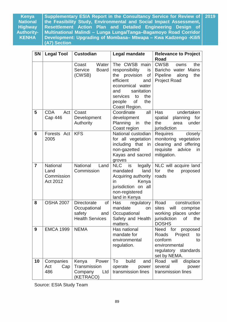
Kenya National Highway
Authority-KENHA
Supplementary ESIA Report in the Consultancy Service for Review of the Feasibility Study, Environmental and Social Impact Assessment, Resettlement Action Plan and Detailed Engineering Design of Multinational Malindi – Lunga Lunga/Tanga–Bagamoyo Road Corridor Development: Upgrading of Mombasa– Mtwapa – Kwa Kadzengo -Kilifi (A7) Section
2019
89
SN Legal Tool Custodian Legal mandate Relevance to Project Road
Coast Water Service Board (CWSB)
The CWSB main responsibility is the provision of efficient and economical water and sanitation services to the people of the Coast Region.
CWSB owns the Baricho water Mains Pipeline along the Project Road
5 CDA Act Cap 446
Coast Development Authority
Coordinate all development Planning in the Coast region
Has undertaken spatial planning for the area under jurisdiction
6 Forests Act 2005
KFS National custodian for all vegetation including that in non-gazetted Kayas and sacred groves
Requires closely monitoring vegetation clearing and offering requisite advice in mitigation.
7 National Land Commission Act 2012
National Land Commission
NLC is legally mandated land Acquiring authority in Kenya jurisdiction on all non-registered land in Kenya
NLC will acquire land for the proposed roads
8 OSHA 2007 Directorate of Occupational safety and Health Services
Has regulatory mandate on Occupational Safety and Health matters.
Road construction sites will comprise working places under jurisdiction of the DOSHS
9 EMCA 1999 NEMA Has national mandate for environmental regulation.
Need for proposed Roads Project to conform to environmental regulatory standards set by NEMA.
10 Companies Act Cap 486
Kenya Power Transmission Company Ltd (KETRACO)
To build and operate power transmission lines
Road will displace several power transmission lines
Source: ESIA Study Team

Kenya National Highway
Authority-KENHA
Supplementary ESIA Report in the Consultancy Service for Review of the Feasibility Study, Environmental and Social Impact Assessment, Resettlement Action Plan and Detailed Engineering Design of Multinational Malindi – Lunga Lunga/Tanga–Bagamoyo Road Corridor Development: Upgrading of Mombasa– Mtwapa – Kwa Kadzengo -Kilifi (A7) Section
2019
90
iii) Third party interests (TPI) This includes any interests outside categories (i) and (ii) such as non-classified access routes traversing the jurisdiction, wildlife migratory corridors in private lands, informal traders, CBOs, NGOs, FBOs within the traverse area.
8.2.2: Stages in Stakeholder Consultations
Stakeholder Consultation in the ESIA process took place in 2 Stages as follows:-
Preliminary Stage Consultations: This targeted sensitisation aimed at building consensus on selection of alternative by pass alignments.
Design Stage Consultations: Activities at design stage built on consultations already undertaken at prefeasibility with the aim of consolidating broader stakeholder input in the process.
Progress achieved so far is highlighted in sections below.
8.3: PROGRESS AND OUTCOME FROM STAKEHOLDER ANALYSIS
8.3.1: Preliminary Stage Consultations
Appendix 8.1 provides a full dossier on Pre-feasibility Stage Consultations, data on which is summarised in Table 8.1 below. Stakeholder engagement entailed activities as follows:-
(i) Public Hearing meetings:- A total of 6 public hearing meetings were held for purposes of sensitising residents along the proposed traverse on the road development project. Through this method, over 603 residents were accessed while others were met during on the ground traversing.
Table 8.2: Summary of the Pre-feasibility Stage Consultations
Meeting Date Target Attendance
Jambo Travellers hotel- Mtwapa
27thJune 2018 Leaders for Kilifi County
92
Baobab Resort- Nyali 28th June 2018 Leaders in Mombasa County
52
Kongowea Community Hall
28th June 2018 Public Baraza 233
Mtwapa Community Ground
27th June 2018 Public Baraza 101
Mtwapa Professional Forum
14th September 2018
Plenary Session 50
Dissemination meeting 31st Oct 2018 Leaders from Mombasa and Kilifi
75
Total 603

Kenya National Highway
Authority-KENHA
Supplementary ESIA Report in the Consultancy Service for Review of the Feasibility Study, Environmental and Social Impact Assessment, Resettlement Action Plan and Detailed Engineering Design of Multinational Malindi – Lunga Lunga/Tanga–Bagamoyo Road Corridor Development: Upgrading of Mombasa– Mtwapa – Kwa Kadzengo -Kilifi (A7) Section
2019
91
Plate 8.1: The Meeting at Kongowea Social Hall
ii) Meetings with Special Interest Groups Three meetings were held bringing together 198 participants as tabulated below.
(iii) Focus Group Discussions: Numerous FGDs were held for purposes of explaining the project to special interest groups namely;- NEMA, KFS, Bamburi Cement Ltd (2 meetings) among others.
(iv) Key Informant Interviews: Under this category, a cross section of stakeholders were met and these included; civil servants, local government officials and the local residents. Consultations took place in respective offices and in the field where possible. Consultations were made either with individual officers or in Focus Group Discussions involving several officers in a group. For this category of stakeholders, a semi-structured questionnaire was used. Discussions started with the consultant team explaining the project to the target officer following which, they were asked to identify their fundamental concerns on the same. After discussion, the officers were requested to fill and sign the form administered by the consultant. This system was deemed useful and as a strategy to cut down on paperwork work while capturing signed comments of target informants.
A total of 27 other meetings were held with Key Informants either in or outside of government (Table 8.2). Majority were with GOK and County Departments whose
Meeting Date Target Attendance
Chief’s Office 10th July 2018 Roadside Traders Leaders 122
MPC Mtwapa 24th July 2018 Mtwapa Boda Boda Leaders 47
MPC Mtwapa 24th July 2018 Mtwapa Church Leaders 29
Total 198

Kenya National Highway
Authority-KENHA
Supplementary ESIA Report in the Consultancy Service for Review of the Feasibility Study, Environmental and Social Impact Assessment, Resettlement Action Plan and Detailed Engineering Design of Multinational Malindi – Lunga Lunga/Tanga–Bagamoyo Road Corridor Development: Upgrading of Mombasa– Mtwapa – Kwa Kadzengo -Kilifi (A7) Section
2019
92
opinion was sought towards harmonizing the proposed development with sectoral policies and strategies.
8.3.2: Comments/Concerns from the Public Hearing Meetings
Core comments and outcome of the Public hearing meetings are summarised in tabular
form below.
Table 8.3: Summary of Comments from Public Hearing Meetings
Forum Core concerns/ outcome
Jambo Travellers
Hotel- Mtwapa Kilifi County Government supports the project and will
collaborate with KeNHA and National Government to
ensure success.
Former Mtwapa MP recommended then Mtwapa
Intergraded Development Plan that he lobbied for to be
harmonized with the proposed road designs.
Khan Muhamed stated that one of the major causes of
traffic congestion in Mtwapa is the weigh bridges. He
suggested the designs to locate weigh bridges away from the
main carriage way.
Mr. Baya noted that the recent demolitions of structures on
the road reserve were done with biasness.
Madam Nina stated that Mtwapa has no functional drainage
and the proposed road project will further harvest storm
water and that proper drainage system should be
incorporated in the design.
David Wahome suggested that the designs should
incorporate footbridges and stages for picking and dropping
passengers.
Baobab Resort- Nyali MCA Frere Town requested for provision of bus stops at the
service lanes.
Mr. Francis noted that a lot of traffic is experienced around
sports and Ziwa la Ngo’mbe and with that the design should
incorporate foot bridges around the area and all other areas
that are highly populated to ease for pedestrian crossing and
safety and noted that there was no notice issued on the
demolitions on the road reserve. In future demolitions, there
should be public participation and people be informed on
when the project will begin unlike the previous demolitions
of structures on the road reserve.
Engineer Howard made it clear that the demolishing was
done to recover the road reserve and stated that there is a
procedure for demolishing where notices are given and are
followed through sensitization meetings where the affected

Kenya National Highway
Authority-KENHA
Supplementary ESIA Report in the Consultancy Service for Review of the Feasibility Study, Environmental and Social Impact Assessment, Resettlement Action Plan and Detailed Engineering Design of Multinational Malindi – Lunga Lunga/Tanga–Bagamoyo Road Corridor Development: Upgrading of Mombasa– Mtwapa – Kwa Kadzengo -Kilifi (A7) Section
2019
93
Forum Core concerns/ outcome
agree on timelines for demolishing so that the owners can
salvage any materials they may need. The procedure is
important because most of those who have encroached the
road reserve earn their livelihoods there. He further urged
the stakeholders to help in securing the road reserve and he
also noted that there was a programme for marking the
extent of the road reserve with marker posts which had
already started.
The consultant noted that KeNHA is in the process of
marking the extent of the road reserve and if there will be
any acquisition with the proposed project, there will be
compensation that will be followed by a 30-day notice.
The Regional Director KFS noted that the proposed project
will affect mangroves and several trees along the road
reserve and thus plans of rehabilitation for the degraded
areas should be made clear.
The consultant noted that an inventory of all the mangroves
damaged will be done and compensated by planting them
somewhere else. Trees to be cut are those that will be on
the construction area and the same types of trees will be
replanted during reforestation.
Marine Officer from NEMA regional coordinator
emphasized the need for Environmental Management Plan
factoring in on how to manage forestry; identify the size of
area to be affected and compensate the same area of lost
cover. He also suggested that it would be important to
identify where the storm drain will drain to avoid affecting
another place.
The consultant made it clear that the proposed storm drain
will be provided underneath the road and discharge at Nyali
creek. The discharge will collect oils and other pollutants
which will collect at the sea. However, there will be
installation of grease filters and the necessary measures to
reduce contaminants discharging into the sea will be applied
and that all run off will be treated before it is disposed into
nature.
The Marine officer advised that it should be ensured that the
design does not omit footbridges in the most critical areas
and that mapping should be done for the entire corridor to
identify where people are crossing frequently and install

Kenya National Highway
Authority-KENHA
Supplementary ESIA Report in the Consultancy Service for Review of the Feasibility Study, Environmental and Social Impact Assessment, Resettlement Action Plan and Detailed Engineering Design of Multinational Malindi – Lunga Lunga/Tanga–Bagamoyo Road Corridor Development: Upgrading of Mombasa– Mtwapa – Kwa Kadzengo -Kilifi (A7) Section
2019
94
Forum Core concerns/ outcome
footbridges.
KWS Officer noted that the marine park neighbours the
corridor and the drainage will lead affect the coral reefs
because of the sediments and will also lead to soil erosion.
The consultant made it clear that sediment traps will be
applied in discharging run off and will not be discharged in
any coral reefs.
Design Engineer from Mombasa Water Sanitation and
Supply requested for provision of adequate road crossings
for pipelines at designated intervals, underground service
tunnels as opposed to foot bridges since the tunnels will
serve the pedestrians and provide for the pipelines way
leave and are also easier to clean and maintain as compared
to service ducts. Also adequate way-leave for other utilities
like electricity poles and the network cables. Adequate
notice to be given to the owners of such utilities so that they
can be moved before construction commences.
Francis Mwange from PCEA Milele Church was concerned
how people will be able to access the road at Bamburi since
there will be an interchange. It was agreed that there will be
an interchange at Mtopanga and service lanes and since the
design is still in the development stage, there will be
considerations for all the accesses.
Archaeologist from National Museums of Kenya stated that
there are several monuments along the corridor; Kengeleni
bell tower, A.C.K Emmanuel Church Frere town and an
adjacent school, Kongowea cemetery which is the only
identity of Frere people to their cultural heritage. At
Mtwapa creek, there is archaeological resource since the
ancient community might have occupied the area and if
there will be any excavations, it should be ensured that the
archaeological resource is covered.
It was agreed that there will be further consultations with
the National Museums of Kenya.
The area chief Mkomani requested for clarification on
whether those who were affected by demolitions on the road
reserve would be compensated for the loss.
Development board member from the MCA’S office
suggested that during implementation the community
should contribute by providing human resource for skilled

Kenya National Highway
Authority-KENHA
Supplementary ESIA Report in the Consultancy Service for Review of the Feasibility Study, Environmental and Social Impact Assessment, Resettlement Action Plan and Detailed Engineering Design of Multinational Malindi – Lunga Lunga/Tanga–Bagamoyo Road Corridor Development: Upgrading of Mombasa– Mtwapa – Kwa Kadzengo -Kilifi (A7) Section
2019
95
Forum Core concerns/ outcome
and unskilled labour. It was agreed that the community has
a right to employment and sub- contract and in every big
project, there has to be 40% contribution from the
community including employment and trade.
Assistant Chief Shanzu requested leaders on the ground to
be involved in any project and stated that they were not
consulted in the previous demolishing and urged that similar
stakeholder meetings be conducted at the grassroots.
Village elder Frere town stated the importance of involving
the local administration in mapping of structures to be
affected and copies of those affected and what to be affected
to be distributed to the community.
MOKIFA chairman noted that in some of the projects there
has not been replanting of trees and requested the proposed
project consider landscaping and replanting of trees that
have been cut during the construction
Mtwapa Baraza The community supports the project and also want to be
part of the development.
The traders requested a space to be segregated for them
along the road reserve after the construction to allow them
continue operating their businesses.
The traders requested that a market centre be constructed for
them to allow them operate their businesses with minimal
disturbance.
The proposed project along Mtwapa is an overpass and the
consultant recommends that the traders to have a place for
them to operate below.
The traders request compensation for lost property and
businesses. The Consultant assured the community that
anyone who will be affected by the project or their property,
there will be an inventory of all those affected and their
property and a report will be submitted to the NLC who
decide on the compensation.
The extent of the road reserve should be clearly marked.
Kongowea Baraza The traders requested that the extent of the road reserve be
clearly marked. It was agreed that KeNHA had started
marking the road reserve and assured the community the
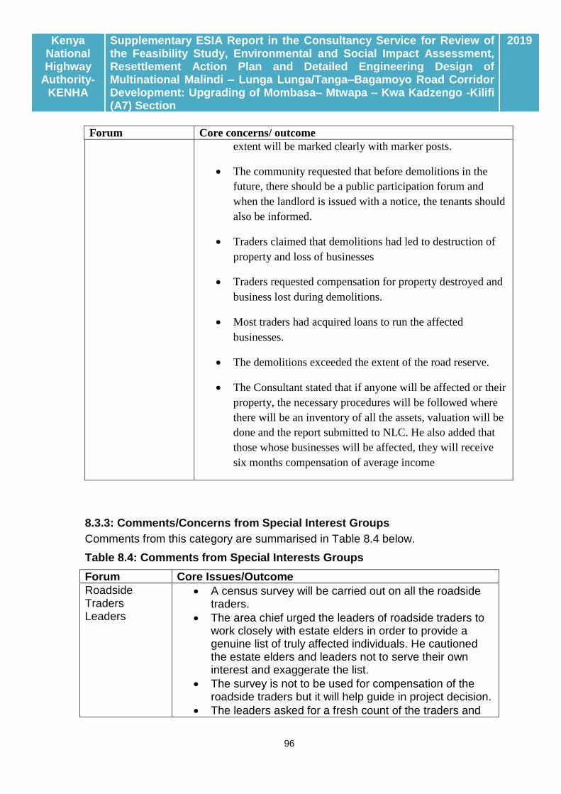
Kenya National Highway
Authority-KENHA
Supplementary ESIA Report in the Consultancy Service for Review of the Feasibility Study, Environmental and Social Impact Assessment, Resettlement Action Plan and Detailed Engineering Design of Multinational Malindi – Lunga Lunga/Tanga–Bagamoyo Road Corridor Development: Upgrading of Mombasa– Mtwapa – Kwa Kadzengo -Kilifi (A7) Section
2019
96
Forum Core concerns/ outcome
extent will be marked clearly with marker posts.
The community requested that before demolitions in the
future, there should be a public participation forum and
when the landlord is issued with a notice, the tenants should
also be informed.
Traders claimed that demolitions had led to destruction of
property and loss of businesses
Traders requested compensation for property destroyed and
business lost during demolitions.
Most traders had acquired loans to run the affected
businesses.
The demolitions exceeded the extent of the road reserve.
The Consultant stated that if anyone will be affected or their
property, the necessary procedures will be followed where
there will be an inventory of all the assets, valuation will be
done and the report submitted to NLC. He also added that
those whose businesses will be affected, they will receive
six months compensation of average income
8.3.3: Comments/Concerns from Special Interest Groups
Comments from this category are summarised in Table 8.4 below.
Table 8.4: Comments from Special Interests Groups
Forum Core Issues/Outcome
Roadside Traders Leaders
A census survey will be carried out on all the roadside traders.
The area chief urged the leaders of roadside traders to work closely with estate elders in order to provide a genuine list of truly affected individuals. He cautioned the estate elders and leaders not to serve their own interest and exaggerate the list.
The survey is not to be used for compensation of the roadside traders but it will help guide in project decision.
The leaders asked for a fresh count of the traders and

Kenya National Highway
Authority-KENHA
Supplementary ESIA Report in the Consultancy Service for Review of the Feasibility Study, Environmental and Social Impact Assessment, Resettlement Action Plan and Detailed Engineering Design of Multinational Malindi – Lunga Lunga/Tanga–Bagamoyo Road Corridor Development: Upgrading of Mombasa– Mtwapa – Kwa Kadzengo -Kilifi (A7) Section
2019
97
not use the list provided during the meeting on 28th June 2018 since the list had not captured all the roadside traders who will be affected by the proposed project.
It was agreed that the leaders will only be given lunch allowances since the exercise will also help them in identifying all the traders in their areas.
It was agreed that for the sand traders, only those selling along the road reserve and their employees will be enumerated but not their clients.
It was made clear that during the census only basic information will be collected but after the census, some traders will be sampled for socio-economic survey after obtaining the actual number of traders.
Mtwapa Boda Boda Leaders
All feeder roads to be provided with smooth access with the proposed project since most Boda Boda (motorcycle) operators use the feeder roads.
There is a likelihood that the Boda Boda stages will be affected and the operators requested that the proposed project to consider providing Boda Boda stages.
Provide local employment opportunities during implementation.
Since the proposed project will be a highway, there will be more traffic and the project has to consider the safety of the people by providing footbridges and underpasses to reduce potential accidents.
Provision of bus stops and parking shade for the Boda Boda.
Capacity building to be done for the motorists and pedestrians since most of them are not conversant with traffic rules and road usage.
The current Mtwapa Bridge experiences drainage issues; water collecting at the bridge and requested this be addressed in the proposed bridge.
Use proven technology to protect the bridge and not road blocks since it causes traffic.
Provide security at the footbridges and the underpasses.
Mtwapa Church Leaders
It was agreed that land acquisition will be done from plots adjacent to the road reserve which will be compulsory acquisition but for the earlier demolitions, it was for property on the road reserve.
On acquisition of land with no title deed, the constitution empowers the National Land Commission to negotiate with the non- title deed holder and compensate them on good faith. It was made clear that the consultants will

Kenya National Highway
Authority-KENHA
Supplementary ESIA Report in the Consultancy Service for Review of the Feasibility Study, Environmental and Social Impact Assessment, Resettlement Action Plan and Detailed Engineering Design of Multinational Malindi – Lunga Lunga/Tanga–Bagamoyo Road Corridor Development: Upgrading of Mombasa– Mtwapa – Kwa Kadzengo -Kilifi (A7) Section
2019
98
not be involved in solving land disputes but only record and forward to National Land Commission.
The current Mtwapa Bridge cannot withstand the anticipated traffic but it will still remain to be used as a service lane to Mtwapa and pedestrian walkway.
Traffic surveys and census will be conducted to determine the location of crossing infrastructures.
Footbridges and underpasses to be provide near the various institutions for easier crossing by the pedestrians and even cater for the need of people with disability and the elderly.
Access to the churches should not be restricted during construction.
Provide adequate information and give advance notices before conducting activities that affect people’s properties.
With the proposed acquisition, there will be no destruction of private property before compensation, notices will be issued and the affected given time for salvage their property.
8.3.4: Comments/Concerns from Key Informants and Lead Agencies
A total of 40 Key Informants were consulted in both Mombasa and Kilifi Counties with outcome as tabulated in 8.5 below.
Table 8.5: Comments from Key Informant Interviews
Institution Name Designation Issues Raised
Department of Environment
Dr. Neto Chief Officer- Environment
Raw materials for road construction will be mined from the town resulting to open quarries and thus there should be proper management plan to mitigate on the impacts.
The county is thinking of rehabilitating quarries and may be interested in waste generated during construction to backfill the quarries.
Sensitive areas along the traverse are the Mtwapa creek and Haller Park.
The livelihood earners along the road to be clearly documented.
Dust must be well managed since most hotels and restaurants are along the road.
Construction should not disrupt traffic because there are a lot of activities along the traverse particularly Kongowea, Bombululu and Pirates.

Kenya National Highway
Authority-KENHA
Supplementary ESIA Report in the Consultancy Service for Review of the Feasibility Study, Environmental and Social Impact Assessment, Resettlement Action Plan and Detailed Engineering Design of Multinational Malindi – Lunga Lunga/Tanga–Bagamoyo Road Corridor Development: Upgrading of Mombasa– Mtwapa – Kwa Kadzengo -Kilifi (A7) Section
2019
99
The stretch between VOK and Bombululu has poor drainage and needs to be addressed.
There is heavy traffic along Kongowea, Mwishomoroni, Kisauni and Nyali and designs to provide correctional measures (interchanges) at heavy traffic junctions.
Mombasa County
Stephen Wambua Kitunga
County Director
The following are issues that should be considered;
The road traverses sensitive ecosystem (Mtwapa Creek)
Flooding around pirates should be solved with the proposed project.
There should be a compensatory program for Mangroves that will be destroyed along Mtwapa Creek.
There is likelihood of siltation of the Mtwapa creek hence need for a comprehensive mitigation plan.
Provide a documented plan for implementation for dust mitigation.
All borrow pits to be subjected to EIA if not captured under the current study.
All borrow pits to be subjected to EIA
Traffic management plan to be developed for implementation with clear alternative routes.
Storm water drains to be provided in the design and implemented.
Walkways and foot bridges to be provided in the design and implemented.
Full disclosure of the proposed project to all relevant and interested stakeholders.
National Museums of Kenya
Philip Wanyama
Archaeologist
The likelihood of availability of cultural resource e.g. archaeological material and natural heritage resource of sacred forests within the traverse and National Museums of Kenya team should be involved during feasibility and pre-development planning of the proposal development both in Mombasa and Kilifi counties. Heritage resource can be known (declared as monument as per Heritage and Museum Act 2006). It can also be unknown since archaeological material is presumed to be

Kenya National Highway
Authority-KENHA
Supplementary ESIA Report in the Consultancy Service for Review of the Feasibility Study, Environmental and Social Impact Assessment, Resettlement Action Plan and Detailed Engineering Design of Multinational Malindi – Lunga Lunga/Tanga–Bagamoyo Road Corridor Development: Upgrading of Mombasa– Mtwapa – Kwa Kadzengo -Kilifi (A7) Section
2019
100
available anywhere and thus proved/unproved through scientific study. National heritage can also be found both on land and underwater contexts.
NEMA Regional Coordinator
Martin Shimba
Compliance/Enforcement
There should be close collaboration with department of trade on how to engage the small traders at Nyali and Bombululu who will be displaced.
The road should not hamper movement of people along the public beach. (Human traffic is high during weekends and school holidays.
There is a likelihood that Mangroves and marine life at Mtwapa creek will be impacted and a study should be undertaken to assess the impacts.
Compensation should be effected for any acquisition along the traverse.
A study should be done on the wetland at Kwa Kadzengo to assess biodiversity/ hydrological impacts and WRMA should be involved.
Find out on any proposed infrastructure like water, communication or sewer from Mombasa County Government and Kilifi County Government and find out how they can be integrated with the proposed road development.
Design of the road should take into account future developments.
James Kamula
There should be compensation for any loss of mangroves to be experienced at Mtwapa creek. This can be done by providing in the EMP planting of mangroves elsewhere covering same area or more to be affected.
A comprehensive social and economic assessment should be done to establish the number of homes and businesses to be affected and compensation should be done to the affected.
Project has the potential to make flood situation in Mombasa worse if the dual carriage is done without drainage thus the design should incorporate drainage systems to take care of surface run-off.

Kenya National Highway
Authority-KENHA
Supplementary ESIA Report in the Consultancy Service for Review of the Feasibility Study, Environmental and Social Impact Assessment, Resettlement Action Plan and Detailed Engineering Design of Multinational Malindi – Lunga Lunga/Tanga–Bagamoyo Road Corridor Development: Upgrading of Mombasa– Mtwapa – Kwa Kadzengo -Kilifi (A7) Section
2019
101
The traffic is likely to get worse if dual carriage is done without interchanges at road junction points like Bamburi and lights.
Kenya Forest Service
Simon Wahome
Regional Director
Mangroves will be affected meaning marine ecosystems will be displaced even though minimal. There should be rehabilitation through replanting of mangroves in the neighbouring lands.
Trees will be cut along Nyali- Mtwapa road affecting the good scenery. Permits should be acquired from KFS before cutting the trees and plot owners neighbouring the reserve should be coerced to plant trees.
Environmental management plan to factor in all trees.
There is a need to come up with an inventory of all the trees animals within the project area.
Endemic birds are found in Arabuko Sokoke forest and thus the project area is an important bird area.
Coast Development Authority
J. Wainaina
Manager engineer services
Three areas currently experience traffic bottlenecks; Nyali junction, Bombululu and Mtwapa- hence design to be considerate of pedestrians and should not disrupt flow of pedestrians particularly around Kongowea market.
Provide footbridges at key markets and junctions and an additional foot bridge at maweni junction.
Box culverts are recommended due to criminal matters.
Consider another bridge only dedicated to Nyali traffic while the current one remain for north bound traffic.
Department of Trade, Industrialization, Cooperative Development
AbdulwahMbarak
Chief officer The county has lost revenue as a result of the demolitions and has not been able to settle the traders who were affected by the demolitions.
2 types of traders will be affected; those operating on the road reserve and those operating within a shop.
The county proposes a piece of land to be acquired for the traders and proposes VOK land since it is easy to acquire public land
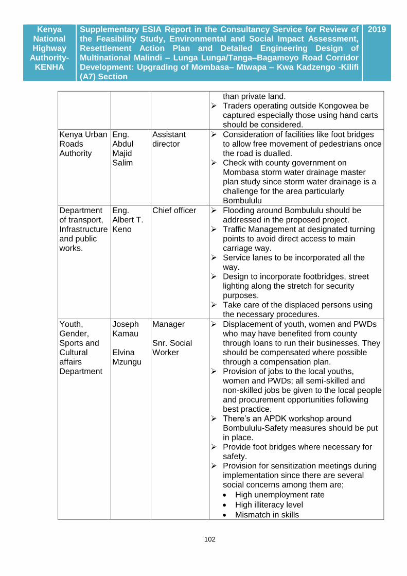
Kenya National Highway
Authority-KENHA
Supplementary ESIA Report in the Consultancy Service for Review of the Feasibility Study, Environmental and Social Impact Assessment, Resettlement Action Plan and Detailed Engineering Design of Multinational Malindi – Lunga Lunga/Tanga–Bagamoyo Road Corridor Development: Upgrading of Mombasa– Mtwapa – Kwa Kadzengo -Kilifi (A7) Section
2019
102
than private land. Traders operating outside Kongowea be
captured especially those using hand carts should be considered.
Kenya Urban Roads Authority
Eng. Abdul Majid Salim
Assistant director
Consideration of facilities like foot bridges to allow free movement of pedestrians once the road is dualled.
Check with county government on Mombasa storm water drainage master plan study since storm water drainage is a challenge for the area particularly Bombululu
Department of transport, Infrastructure and public works.
Eng. Albert T. Keno
Chief officer Flooding around Bombululu should be addressed in the proposed project.
Traffic Management at designated turning points to avoid direct access to main carriage way.
Service lanes to be incorporated all the way.
Design to incorporate footbridges, street lighting along the stretch for security purposes.
Take care of the displaced persons using the necessary procedures.
Youth, Gender, Sports and Cultural affairs Department
Joseph Kamau Elvina Mzungu
Manager Snr. Social Worker
Displacement of youth, women and PWDs who may have benefited from county through loans to run their businesses. They should be compensated where possible through a compensation plan.
Provision of jobs to the local youths, women and PWDs; all semi-skilled and non-skilled jobs be given to the local people and procurement opportunities following best practice.
There’s an APDK workshop around Bombululu-Safety measures should be put in place.
Provide foot bridges where necessary for safety.
Provision for sensitization meetings during implementation since there are several social concerns among them are;
High unemployment rate
High illiteracy level
Mismatch in skills

Kenya National Highway
Authority-KENHA
Supplementary ESIA Report in the Consultancy Service for Review of the Feasibility Study, Environmental and Social Impact Assessment, Resettlement Action Plan and Detailed Engineering Design of Multinational Malindi – Lunga Lunga/Tanga–Bagamoyo Road Corridor Development: Upgrading of Mombasa– Mtwapa – Kwa Kadzengo -Kilifi (A7) Section
2019
103
Drug and substance abuse.
Prostitution
HIV/AIDS
Street families
Gambling
County Government of Mombasa
County Secretary
Consult widely on displacement and where land acquisition is eminent involve NLC Utility services will be affected by the road development, therefore consult and integrate available plans e.g. ISUDP (MV2035) and Mombasa city master plan.
Water Resource Authority
Susan Mwangi
Ground Water Officer
Ground water resource pollution and over abstraction of ground water resources.
There should be compliance on all activities touching water resources.
A study should be carried out on the Kwa Kadzengo wetland to assess the impacts.
Continue in a regular basis engagement during the entire project period.
County Occupational safety and health officer
Samuel Kimani
County Occupational Safety and health officer
KeNHA should engage with DOSH to ensure smooth running of the project. There should be adequate induction of the
workers to ensure they are aware of their rights in safety health and welfare.
There may be need for KeNHA to facilitate DOSH execute its mandate by for instance building capacity.
Ministry of Agriculture, Livestock and Fisheries
Hassan Mwamtoa
County Executive Committee Member
Drainage and storm water can be harvested and redirected towards Mwakirunge to provide for the much needed water for irrigation. The county can provide political good for the same.
There are two landing sites at Mtwapa which will be affected namely Marina and Kidongo. The fisheries department should be notified on any meetings in order to send representation.
There is a proposed fish caging along Mtwapa Creek. Plans have been fronted at the county level for fish caging along the creek.
The creek is also a breeding area for various fish species thus there should be minimal impact on mangroves because when affected the entire breeding province

Kenya National Highway
Authority-KENHA
Supplementary ESIA Report in the Consultancy Service for Review of the Feasibility Study, Environmental and Social Impact Assessment, Resettlement Action Plan and Detailed Engineering Design of Multinational Malindi – Lunga Lunga/Tanga–Bagamoyo Road Corridor Development: Upgrading of Mombasa– Mtwapa – Kwa Kadzengo -Kilifi (A7) Section
2019
104
of marine fish is affected. Involve the fisheries department at all level
of planning.
Shimo La Tewa Prisons
J.M Maingi
Officer in Charge
Compensation should be done prior to start of any civil works.
Restrict acquisition on the right side of the prison
Provide direct access to the prison and avoid underpass and Foot Bridge near the prisons.
Avoid raised roads and consider via ducts near prison.
CSR- Consider renovating and building a new wall for the prison.
Design to provide crossings for staff and designated bus stop for prison staff and family whose population is 3,000.
Compensate for all trees and tree nurseries but should allow the prison to salvage all their trees and other affected property.
Consultations should also be done with the regional headquarters (Coast), Prison headquarters (Nairobi) and the ministry.
Shanzu Law Courts
Robert Kioko
Executive Officer
Development of a highway is welcomed and will correct constant traffic congestion along the road.
Provision of access points to the court should be considered.
Kenya Wildlife Service
Sirya
Mwakkam
sha
Karisa
Flooding and drainage system majorly from the main tunnel that might emanate from Bombolulu – Nyali site might carry insolvent sediments into the sea and other pollutants which might smother coral reefs, speed the growth of damaging algae, and lower water quality.
Sea level is rising at about 1 millimetre per year, which, under normal circumstances, habitats can adapt to, but the loss of inshore coral reefs and coastal mangrove forests adds to the potential damage caused by sea level rise and coastal erosion. Already the loss of coastal land due to erosion is an ever-growing concern to developers along the Coastal line.
Terrestrial sediment fluxes can result in

Kenya National Highway
Authority-KENHA
Supplementary ESIA Report in the Consultancy Service for Review of the Feasibility Study, Environmental and Social Impact Assessment, Resettlement Action Plan and Detailed Engineering Design of Multinational Malindi – Lunga Lunga/Tanga–Bagamoyo Road Corridor Development: Upgrading of Mombasa– Mtwapa – Kwa Kadzengo -Kilifi (A7) Section
2019
105
increased sedimentation and turbidity in receiving marine waters, with detrimental impacts on coral reef ecosystems.
A water harvesting and collection facility to be thought as a better alternative and a more viable solution to environmental related problems. When this water is well treated, it could be useful to the 2 Counties – Mombasa and Kilifi - in many ways.
Mombasa Water Supply & Sanitation Company
David
Ngumbao
Planning and Design Manager
Provision of adequate pipeline crossings and service tunnels that is free from infrastructure on top of it. Wayleave should be adequate enough to allow for access and maintenance. Service tunnels would be ideal for bigger diameter pipelines of diameters of equal to or exceeding 200mm. Pipe-line crossings for smaller diameter pipelines of diameter of and not exceeding 150mm may be provided as service ducts of adequate diameter for ease of operation and maintenance.
Design to consider providing pedestrian under passes which may double as pipeline service tunnels.
Acquisition of land for the road project should consider provision of adequate pipeline way leave for relocation of existing water and waste water assets or proposed pipelines.
Design for relocation of water and waste water assets should be undertaken concurrently with the road design to avoid overlooking some concerns.
The consultant and KeNHA should maintain the good communication throughout the project period.
Kenya Power Lighting Company
Mzee
Mwajabe
Property expert KPLC
The draft design should establish how many lines are affected and the study should incorporate space of relocation for utilities. During acquisition, there should be acquisition for utilizes on the road reserve.
The road reserve is the best corridor for the utilities because of ease of maintenance and safety.
In most cases the design incorporates

Kenya National Highway
Authority-KENHA
Supplementary ESIA Report in the Consultancy Service for Review of the Feasibility Study, Environmental and Social Impact Assessment, Resettlement Action Plan and Detailed Engineering Design of Multinational Malindi – Lunga Lunga/Tanga–Bagamoyo Road Corridor Development: Upgrading of Mombasa– Mtwapa – Kwa Kadzengo -Kilifi (A7) Section
2019
106
acquisition for road reserve but during implementation it appears it was not acquired thus becoming a challenge.
The time of relocation is handled on case to case basis and delays affect delivery of services to people which at times goes contrary to the agreement and according to the Energy Act KPLC has the mandate to provide power 24hrs a day, 7 days a week.
Walkways, bus parks and stages should be incorporated in the design.
8.4.3: Way forward with Stakeholder Engagement Stakeholder engagement is a continuous process. With the ESIA process now proceeding to the Public Review Stage, it is expected that more stakeholder comments will be received to further shape and further inform project development.

Kenya National Highway
Authority-KENHA
Supplementary ESIA Report in the Consultancy Service for Review of the Feasibility Study, Environmental and Social Impact Assessment, Resettlement Action Plan and Detailed Engineering Design of Multinational Malindi – Lunga Lunga/Tanga–Bagamoyo Road Corridor Development: Upgrading of Mombasa– Mtwapa – Kwa Kadzengo -Kilifi (A7) Section
2019
107
CHAPTER NINE: POTENTIAL IMPACTS AND MITIGATION MEASURES
9.1: BACKGROUND
This chapter provides an analysis of the potential impacts likely to ensue from implementation of project activities. In predicting the impacts, a checklist of environmental impacts developed by diverse authorities (FAO, 1986; EU 1993) has been employed. Interpretation of impacts was based on a ranking system of high, moderate and low depending on the nature, scope (temporal and geographical) and resilience of the impacts. Impacts can be positive or negative, direct or indirect. The magnitude of each impact is described in terms of being significant, minor or negligible, temporary or permanent, long-term or short-term, specific (localized) or widespread, reversible or irreversible. Generally, temporary impacts having no obvious long-term consequences are regarded as being minor. But those with long-term repercussions are classified as significant. Significant positive impacts are usually associated with improved access, which is the prime objective of the roads construction project.
Potential impacts on various environmental components due to different project activities during pre-construction, construction and Operation stages have been identified Table 10.1 below outlines impacts anticipated from the Project Road. 9.2: DESIGN PHASE IMPACTS
9.2.1: Positive Impacts of design Stage:
As at the time of preparing this report, a feasibility study and Preliminary Design has been undertaken and completed and among other findings, few if any adverse impacts were attributed to this process. Generally, the design phase is associated with positive impacts mainly manifested through creation of business opportunities for professionals involved in the design work, support staff hired in the enumeration survey, etc, while the country benefits from generation of additional planning data which will influence policy decisions within long time frames. Certainly, the database compiled from design report will find consumption far beyond the confines of this project.
9.2.2: Adverse impacts at Design Stage: Adverse impacts would mainly be manifested through site disturbances and accidents associated with field survey work.

Kenya National Highway
Authority-KENHA
Supplementary ESIA Report in the Consultancy Service for Review of the Feasibility Study, Environmental and Social Impact Assessment, Resettlement Action Plan and Detailed Engineering Design of Multinational Malindi – Lunga Lunga/Tanga–Bagamoyo Road Corridor Development: Upgrading of Mombasa– Mtwapa – Kwa Kadzengo -Kilifi (A7) Section
2019
108
Table 9.1: Schedule of anticipated impacts Project Phase Source of
Impact Serial Potential Impact Severity
* Persistence Potential for
secondary impacts
Design Stage (1)
Design Studies, field surveys and inventories
1.1 Creation of temporary opportunities for gainful employment
2P Short-term
1.2 Generation of additional site-specific data /study reports
P Long-term
1.3 Capacity building and sensitization
P Long-term
1.4 Minor site disturbances from Geotechnical investigation, bush clearing etc. during survey work
N Short-term
Reversible None
1.5 Minor accidents during survey work
N Short-term
Reversible Minor
Construction Phase (2)
Supply of materials
2.1 Business opportunities in supply and transport of construction materials
2P Short term
2.2 Road hazards in material transportation
N Short-term
Reversible Irreversible impacts
2.3 Degradation along material sourcing and transport
2N Long-term
Reversible Social and economic costs
2.4 Carbon footprint in the transportation of construction materials
N Short-term
Reversible Climate change and impacts
2.5 Introduction of invasive/ alien species in construction materials
2N Long-term
Irreversible Weakened ecological
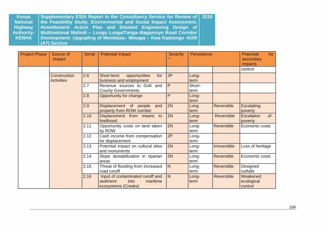
Kenya National Highway
Authority-KENHA
Supplementary ESIA Report in the Consultancy Service for Review of the Feasibility Study, Environmental and Social Impact Assessment, Resettlement Action Plan and Detailed Engineering Design of Multinational Malindi – Lunga Lunga/Tanga–Bagamoyo Road Corridor Development: Upgrading of Mombasa– Mtwapa – Kwa Kadzengo -Kilifi (A7) Section
2019
109
Project Phase Source of Impact
Serial Potential Impact Severity *
Persistence Potential for secondary impacts
control
Construction Activities
2.6 Short-term opportunities for business and employment
2P Long-term
2.7 Revenue sources to GoK and County Governments
P Short-term
2.8 Opportunity for change P Long-term
2.9 Displacement of people and property from ROW corridor
2N Long term
Reversible Escalating poverty
2.10 Displacement from means to livelihood
2N Long-term
Reversible Escalation of poverty
2.11 Opportunity costs on land taken by ROW
2N Long-term
Reversible Economic costs
2.12 Cash income from compensation for displacement
2P Long-term
2.13 Potential impact on cultural sites and monuments
2N Long-term
Irreversible Loss of heritage
2.14 Slope destabilization in riparian areas
2N Long-term
Reversible Economic costs
2.15 Threat of flooding from increased road runoff
N Long-term
Reversible Designed outfalls
2.16 Input of contaminated runoff and sediment into maritime ecosystems (Creeks)
N Long-term
Reversible Weakened ecological control

Kenya National Highway
Authority-KENHA
Supplementary ESIA Report in the Consultancy Service for Review of the Feasibility Study, Environmental and Social Impact Assessment, Resettlement Action Plan and Detailed Engineering Design of Multinational Malindi – Lunga Lunga/Tanga–Bagamoyo Road Corridor Development: Upgrading of Mombasa– Mtwapa – Kwa Kadzengo -Kilifi (A7) Section
2019
110
Project Phase Source of Impact
Serial Potential Impact Severity *
Persistence Potential for secondary impacts
2.17 Risk of fire hazards during construction
N Short-term reversible
2.18 Loss of carbon sinks in destroyed cover vegetation
N Long-term
Reversible GHG concerns
2.19 Destruction of biodiversity held in undisturbed sites
N Long-term
Reversible Loss of biodiversity
2.20 Nuisances-dust, fumes, vibrations from operation of plant and equipment
2N Short-term
Reversible Health risks
2.21 Social and health hazards of construction crew and labour camps
N Short-term
Reversible Hazards to public health
2.22 Sanitation concerns from construction crew
N Short-term
Reversible
2.23 Occupational health and safety concerns for construction crew
N Short-term
Reversible Impacts of injuries and occasional death
2.24 Disruption of existing infrastructure (water mains, power transmission and data cables)
N Short-term
Reversible Economic costs
2.25 Disruption of services, connectivity, ease of access and
N Short-term
Reversible Economic and social costs

Kenya National Highway
Authority-KENHA
Supplementary ESIA Report in the Consultancy Service for Review of the Feasibility Study, Environmental and Social Impact Assessment, Resettlement Action Plan and Detailed Engineering Design of Multinational Malindi – Lunga Lunga/Tanga–Bagamoyo Road Corridor Development: Upgrading of Mombasa– Mtwapa – Kwa Kadzengo -Kilifi (A7) Section
2019
111
Project Phase Source of Impact
Serial Potential Impact Severity *
Persistence Potential for secondary impacts
normalcy by construction activity
2.26 Pressure on water resources N Short-term
Reversible
2.27 Pollution from construction waste, waste oils and spares
N Short-term
Reversible
Operation Phase (3.0)
Operation of the completed highway
3.1 Benefits from decommissioned contractor camps and facilities
2P Long-term
3.2 Provision of a functional and efficient road connection through North Coast
2P Long-term
3.3 Aesthetic impacts of a new highway
2P Long-term
3.4 Enhanced quality of life from improved delivery of services in Medicare, education, admin, telecommunication, etc
2P Long-term
Irreversible
3.5 Enhanced passenger and cargo movement
2P Long-term
Irreversible
3.6 Enhanced visitor access to the North Coast Tourist attractions
P Long-term
3.7 Reduced traffic congestion and associated pollution
2P Long-term
Reversible
3.8 Opportunity for self-employment in public transport
2P Long-term
Irreversible
3.9 Enhanced value of property 2P Long- Irreversible

Kenya National Highway
Authority-KENHA
Supplementary ESIA Report in the Consultancy Service for Review of the Feasibility Study, Environmental and Social Impact Assessment, Resettlement Action Plan and Detailed Engineering Design of Multinational Malindi – Lunga Lunga/Tanga–Bagamoyo Road Corridor Development: Upgrading of Mombasa– Mtwapa – Kwa Kadzengo -Kilifi (A7) Section
2019
112
Project Phase Source of Impact
Serial Potential Impact Severity *
Persistence Potential for secondary impacts
along upgraded road term
3.10 Pressure on resources and services from emerging urban settlements attracted by the new road
2N Long term
Irreversible
3.11 Pollution of Tudor and Mtwapa creeks from road runoff
2N Long-term
Reversible Ecological risks. Protection measures to be applied
3.12 Curtailed access and ease of movement in villages by the physical barrier
2N Long-term
Irreversible Disruption of social coherence
3.13 The hazard of traffic accidents from speeding vehicles
2N Long-term
Reversible Economic costs. Dualing the road will reduce accidents
3.14 Reduced productivity of vegetation shaded by new bridge
N Long-term
Reversible Weakened ecological control
3.15 Curtailed movement of reptiles and small mammals by the road embankment
2N Long-term
Irreversible Impacts of biological isolation
3.16 Alteration of local hydrology and drainage by paved road surface
2N Long-term
Irreversible Land degradation

Kenya National Highway
Authority-KENHA
Supplementary ESIA Report in the Consultancy Service for Review of the Feasibility Study, Environmental and Social Impact Assessment, Resettlement Action Plan and Detailed Engineering Design of Multinational Malindi – Lunga Lunga/Tanga–Bagamoyo Road Corridor Development: Upgrading of Mombasa– Mtwapa – Kwa Kadzengo -Kilifi (A7) Section
2019
113
Project Phase Source of Impact
Serial Potential Impact Severity *
Persistence Potential for secondary impacts
from erosion
3.17 Land use change due to settlements attracted by new road
N Long-term
Reversible Reduced habitat for avian fauna
3.18 Increased noise from motor vehicles
N Long-term
Irreversible Threats associated with high noise levels
Net environmental worth of the project pre-mitigation
50 29P (29 positive outputs, mainly long-term), 47N (47 adverse outputs, 25 long-term, 11 irreversible), Net score=18N (Net negative impact before mitigation)

Kenya National Highway
Authority-KENHA
Supplementary ESIA Report in the Consultancy Service for Review of the Feasibility Study, Environmental and Social Impact Assessment, Resettlement Action Plan and Detailed Engineering Design of Multinational Malindi – Lunga Lunga/Tanga–Bagamoyo Road Corridor Development: Upgrading of Mombasa– Mtwapa – Kwa Kadzengo -Kilifi (A7) Section
2019
114
9.3: CONSTRUCTION PHASE IMPACTS
Construction is the phase where the bulk of impacts manifest. For clarity purposes, impacts have been grouped together.
9.3.1: Positive impacts
Positive impacts at construction stage will manifest as follows:- Creation of business opportunities: Construction work for the Project Road will entail a huge investment the bulk of which will go into procurement of construction material and hiring of the contractor. Indeed, investment of over Kshs 28.575 Billion within 53.9 km long route of traverse equivalent to Kshs 530.1 million per kilometre will open up extensive trade opportunities while other economic benefits will accrue through creation of employment opportunities for both skilled and semi-skilled labour engaged in construction. At local level, communities will benefit from short-term employment opportunities in the construction activity. Creation of opportunity for change: Relocation of buildings and property from the new road reserve has destabilizing effects to PAPs. However, the same process occasions the need for change such as the need to regularize land and property subdivisions and transfers, the need to settle boundary disputes, the need to formalize inheritance etc which in the long-run provides a stronger foundation for economic growth. Opportunity to earn cash income: Compensation for land taken by the ROW and any properties so displaced occasions an opportunity to earn cash income whose prudent investment in other ventures enhances the economic wellbeing of the affected family. Indeed, investment of over Kshs 3.313 Billion within 53.9 km long route of traverse equivalent to Kshs 61.5 million per kilometre of ROW will occasion major economic impact on affected families and livelihoods.
9.3.2: Negative impacts of construction activity
Adverse impacts at construction stage are likely to manifest as follows: - (i) Displacement from land and assets Displacement from land: By far, the most drastic impact of developing the Project Road is the potential to displace human settlements through land acquisition. From inventory of PAPs undertaken as part of the RAP, development of the 56.1Km road corridor exclusive of interchanges is likely to affect a total of 378 land parcels accounting for 19 Ha (46.9acres) thus dispossessing people of their property. Total structures: The entire road project will displace a total of 388 structures, 359 (92.5%) of which are single storied and mainly semi-permanent. A comprehensive

Kenya National Highway
Authority-KENHA
Supplementary ESIA Report in the Consultancy Service for Review of the Feasibility Study, Environmental and Social Impact Assessment, Resettlement Action Plan and Detailed Engineering Design of Multinational Malindi – Lunga Lunga/Tanga–Bagamoyo Road Corridor Development: Upgrading of Mombasa– Mtwapa – Kwa Kadzengo -Kilifi (A7) Section
2019
115
breakdown of structures by type is provided in the full RAP report prepared for the road project. Potentially displaced population: A total of 1531 PAPs falling in 4 categories are likely to be displaced as enumerated in Table 9.3 below. Essentially, tenants (both residential and traders) comprise majority of the PAPs at 51.8% which goes to confirm the strategic role of the A7 road as an economic enabler in the North Coast area.
Table 9.3: Distribution of PAPs by administrative jurisdiction
PAP Category Total tally Share (%)
Property owners 618 40.4
Residential tenants 221 14.4
Business tenants 572 37.4
Employees 120 7.8
Total 1531 100
Source: This Study
Displacement of livelihoods: Project development will displace livelihoods such as businesses, shop and hotel owners, roadside traders, petty farmers, etc which, though not dependent on the land, actually rely on resources along the proposed road. Such groups with ultimately lose access to means to livelihood.
Opportunity costs in acquired land: Essentially, the bulk of land to be acquired for the upgrading of the Project Road comprises of urban settlements whose acquisition has huge opportunity costs.
(ii) Impacts in material sourcing and transport
Material sourcing areas: Opening up of borrow areas to reach quality stone or murram involves stripping off cover vegetation and top soil with attendant loss of biodiversity and, depending on the depth of quarrying, shallow groundwater pathways can be impacted. Non-rehabilitated quarry spoils also pose a danger people, livestock, and wildlife and can form breeding grounds for mosquitoes.
Blasting and use of explosives: Hazards associated with blasting include accidents to people and livestock, damage to properties, dewatering of springs through earth faulting, nuisances to neighbourhood, among others.
Material transport routes: Some of the access roads to material sites do not exist and construction will entail opening up new ground. Further, in places where there is no road network, inevitable opening up of new feeder roads for delivering labour and materials to the construction site has potential to cause degradation of productive land. If new transport routes will be opened up, these should follow designated reserves to ensure continued use even after road construction is completed.

Kenya National Highway
Authority-KENHA
Supplementary ESIA Report in the Consultancy Service for Review of the Feasibility Study, Environmental and Social Impact Assessment, Resettlement Action Plan and Detailed Engineering Design of Multinational Malindi – Lunga Lunga/Tanga–Bagamoyo Road Corridor Development: Upgrading of Mombasa– Mtwapa – Kwa Kadzengo -Kilifi (A7) Section
2019
116
Material bulking sites: Main concerns include potential spillage and secondary erosion into waterways in case of soil spoils and sand, dust emission and safety hazards to people and property in-case of mass wasting, among others.
Potential for introduction of invasive species: One of the most common adverse impacts of road construction in Kenya is the introduction of invasive species brought in mainly in contaminated building material- stones, sand, ballast, etc. Once introduced, the species spreads quickly to colonize the area and become a noxious weed, of which the best example is the Prosopis chilensis (Mathenge) tree. In case of the proposed road expansion, there is fear that introduction of the Mathenge weed close to the intertidal areas has potential to completely colonize and destroy the mangrove ecosystem with very costly impacts even to local livelihoods and against this background, sites targeted for sourcing of river sand at both Voi and Magarini were investigated.
Without exception, both the Magarini and Voi River sources were found to be heavily infected by the Prosopis (Mathenge) weed and this would render them unsuitable for use in the road construction. However, given that the Magarini sand deposits at Mjana Heri and Timboni are very thick, they can be safely exploited on condition that the top organic layer is isolated in favour of the underlying non-contaminated layers. The environmental specialist at Construction Stage will require monitoring sand sourcing very strictly and undertake surveillance for emergence of Prosopis seedlings all along the new road.
Plate 9.2: Prosopis colonies along Voi River
Loss of biodiversity in undisturbed sites: Undisturbed sites such as sacred groves are known to be reservoirs of floral biodiversity including germplasm stored in the soil gene reserve. While efforts were made to map standing biodiversity along the traverse, the same was not done for soil gene reserves in which case, their reservoirs are not fully appreciated more so, given the long period of viability
Kenya National Highway
Authority-KENHA
Supplementary ESIA Report in the Consultancy Service for Review of the Feasibility Study, Environmental and Social Impact Assessment, Resettlement Action Plan and Detailed Engineering Design of Multinational Malindi – Lunga Lunga/Tanga–Bagamoyo Road Corridor Development: Upgrading of Mombasa– Mtwapa – Kwa Kadzengo -Kilifi (A7) Section
2019
117
dispelled by seed of some indigenous species. Stripping of top soil in such sites could amount to major loss of gene banks of unknown value.
(iii) Concerns from the Contractor’s Camp
Concerns from Contractors Camps are many and diverse causing NEMA to demand stand-alone ESIA studies. Common issues to expect include:-
Generation of liquid effluent including sewage: Cases of effluent water from Contractors’ kitchens and bathroom areas being released into nature in raw form in-spite of reigning legislation are increasingly common and this has potential to compromise quality of water supply for downstream communities.
Waste oils and spares from motor vehicle maintenance yards: Where oil and spares are poorly harnessed, the same are likely to compromise aesthetic quality with potential wash off into water resources. Further, soil already contaminated by oil immediately becomes hydrophobic and can no longer attract or hold water hence rendering it agriculturally inert.
Solid and organic waste: This takes the form of waste food, paper, plastic wrapping, and obsolete computer spares among others. While organic stuff rapidly degenerations naturally, other waste have longer persistence hence posing the growing problem of solid waste accumulation.
Safety hazards: These include fire hazards posed by fuel bulking, use of naked flames in maintenance workshops, accidents in the workplace, build-up of serpents and rodents from poorly stacked stores, etc.
The whole question of basic rights at the workplace: A trend is emerging in Kenya whereby most construction contracts are won by oriental based companies better known for cost effective delivery on contracts but with huge attendant environmental and social costs including contempt for contractual obligations sealed in law, deployment of language challenged supervisors, poor community integration, poor respect for workers’ rights inclusive of basic pay, working hours, grievance procedures among others. It is becoming increasingly common to read of violent confrontations between communities and foreign oriental workers, labour disputes, worker grievances etc, largely traceable to poor work ethics.
Social vices associated with construction crews: Road construction activity will engage and deploy numerous people on a daily basis to villages which have otherwise been culturally isolated from the rest of the world. Such exposure is likely to occasion cultural shocks and tendencies associated with multitudes to the detriment of local residents. Core hazards would include proliferation of social vices key among them commercial sex, drug and alcohol abuse, juvenile delinquency, among others whose pressure points would express in explosion of teenage motherhoods, breakdown of homes, escalation of sexually transmitted diseases including HIV and AIDs, social disorders, among others which would rapidly erode gains associated with cash injection from road construction activity.

Kenya National Highway
Authority-KENHA
Supplementary ESIA Report in the Consultancy Service for Review of the Feasibility Study, Environmental and Social Impact Assessment, Resettlement Action Plan and Detailed Engineering Design of Multinational Malindi – Lunga Lunga/Tanga–Bagamoyo Road Corridor Development: Upgrading of Mombasa– Mtwapa – Kwa Kadzengo -Kilifi (A7) Section
2019
118
(iv) Impacts from construction activity
Disruption of village life: Construction activity will set in motion many activities running simultaneously in villages that have known nothing but sheer laid-back lifestyles. Activities such as relocation of shelters, stripping of the ground together with trees, roads, boundary fences by strange looking machines and people, amidst influx of job speculators and cash windfall from compensation are likely to challenge even the most sober and level headed of villagers. Before people can reorganize and settle to new routines, re-orient to the new way of doing things and getting around, a lot of time may be wasted and this could even turn costly in terms of rural economic activity.
Impact on existing infrastructure and services: The project is likely to interface with several service lines such as water pipelines, power transmission and distribution lines, national highways etc all of which serve vital functions in the local, national and regional economies and whose disruption is likely to occasion massive suffering.
Pressure on fresh water resources: Freshwater is not easy to come by within the entire traverse where communities mainly rely either on tap water, boreholes and shallow wells or plain river water. The design process must allow for alternative source of water such as borehole drilling supplying road construction thus averting pressure on community water sources. The option of sinking boreholes or constructing water pans that can later on revert to communities should be explored.
Occupational health and safety concerns for construction crew: Concerns emanate from industrial/ occupational hazards (injuries, fatalities, ailment, etc) associated with operation of and use of tools, plants and equipment deployed in a major and complex road building project as anticipated under auspices of the Project Road. Construction of a major bridge will pose locally unique challenges all of which compound occupational hazards associated with the project.
Traffic hazards to other road users: Construction vehicles in Kenya are notorious for their wanting respect for traffic rules and the rights of other road users. On numerous occasions, such attitude is a precursor for traffic accidents.
Emission of atmospheric pollutants by moving plant and equipment: Baseline monitoring of air quality undertaken as part of this ESIA indicated that Particulate Matter (PM10) exceeded statutory limits for all stations monitored along the proposed road while day-time noise levels exceeded standards recommended by NEMA. As such, generation of fumes, dust and noise in road construction activity will only compound an already severe situation which could expose people to health hazards. Elevated noise and dust levels are not desired anywhere near human settlements and will require mitigation.
Emissions from the Crusher and Asphalt Plant: Stone Crusher and Asphalt Plants pose the most drastic of environmental impacts through emission of smoke, fumes, dusts, noise, noxious smell, heat and vibrations thus posing dangers to both

Kenya National Highway
Authority-KENHA
Supplementary ESIA Report in the Consultancy Service for Review of the Feasibility Study, Environmental and Social Impact Assessment, Resettlement Action Plan and Detailed Engineering Design of Multinational Malindi – Lunga Lunga/Tanga–Bagamoyo Road Corridor Development: Upgrading of Mombasa– Mtwapa – Kwa Kadzengo -Kilifi (A7) Section
2019
119
operators and neighbourhood residents and their properties. Indeed, dust from crusher plants has been observed to choke and kill crop fields while aggravating respiratory complaints in the neighbourhood.
Plate 9.1: An Asphalt Plant under assembly: NEMA requires stand-alone EIA reports
Generation of soil sediments from cutting and spoiling: The proposed road dualling including excavation for drainage have potential to generate a net 529,400m3 of spoil in which case, extreme caution is required as non- controlled disposal of the surplus soil could see massive wash-off into the Tudor and Mtwapa Creeks thus compromising the aesthetic quality currently exploited as an attraction for water based sport and tourism. Most of the material will be used for grass planting and rehabilitating borrow-pits.
Given the siltation threats currently faced by the Kenya coastline, a comprehensive system for managing the earthworks to militate against soil deposition into the shoreline will have to be developed by the highway team (Legal Notice No. 19 of EMCA 1999-The Environmental Management and Co-ordination (Wetlands, Riverbanks, Lake Shores and Sea Shore Management) Regulations, 2009).
Generation of construction waste: Waste from road construction comprises, existing asphalt layers not re-used, surplus soil, packaging, debris, waste spares and oils, scrap from workshops etc all of which has potential to pose environmental challenges unless appropriately disposed.
Sanitation concerns for construction crews: The massive sea of humanity to be engaged in road construction have specific sanitation needs whose inadequate supply would see any available bush, gully, etc. turned into a toilet with attendant threats to public health.
(v) Impacts on habitat for critical biodiversity
The A7 highway traverses the Kwa Kadzengo swamps where 5 AEWA (Agreement on the Conservation of African-Eurasian Migratory Water Birds) Bird species

Kenya National Highway
Authority-KENHA
Supplementary ESIA Report in the Consultancy Service for Review of the Feasibility Study, Environmental and Social Impact Assessment, Resettlement Action Plan and Detailed Engineering Design of Multinational Malindi – Lunga Lunga/Tanga–Bagamoyo Road Corridor Development: Upgrading of Mombasa– Mtwapa – Kwa Kadzengo -Kilifi (A7) Section
2019
120
namely;- the Zanzibar Somber Greenbul, Cattle Egret, Grey Heron, Sacred Ibis and the Three-banded Plover were encountered. This seasonal marsh is therefore an important habitat for migratory water birds and is in need of conservation. Any loss of this habitat through either drainage or conversion is likely to reduce both the range and habitat required to maintain minimum viable populations of these species and is therefore detrimental.
(vi) The carbon footprint factor
GHG emissions in construction activity: This ESIA Study assumes that all material to be used in road construction will be sourced locally as a way of cutting down on carbon miles. Irrespective of this, transportation to the point of construction will involve burning of fossil fuels and attendant release of GHG gases into the atmosphere. The greater the distance travelled, the more the GHG released. Though carbon emission will be greatly reduced through local sourcing of materials, importation of oil-based products such as fuels, lubricants, bitumen and the steel required in drainage structures has a huge impact on carbon emissions. A study by the World Bank8 estimated carbon emissions in national highway construction at 793.81 tons CO2 per kilometre of which materials sourcing and supply accounted for 66% of all emissions. Applying this model to the Project Road totalling 53.9 kilometres, a potential GHG yield of 42,786 tons is anticipated from construction activity alone out of which, close to 28,239 tons would emit from material sourcing and fabricating activities.
Loss of carbon sink in clearing of 4.8Ha of vegetation: An estimated 7,592 assorted trees equivalent to 4.8Ha of woody vegetation are likely to be displaced in road development. Assuming a modest carbon fixation of 62 g-C m-2 yr-1 (FAO, 2009),9 a carbon sequestration capacity equivalent to 3 metric tonnes could be lost in the cleared vegetation which translates to a net loss to the global fight against GHG accumulation and global warming. Additionally, this would also cumulatively contribute to the alarming deforestation rate in Kenya currently estimated at 12,600 hectares of forest per year equivalent to an average annual deforestation rate10 of 0.34%.
9.4: OPERATION PHASE IMPACTS
Provision of a new road link between Mombasa and Kilifi has numerous benefits of course with some attendant social and environmental costs. These are briefly highlighted in sections below.
(i) Overall strategic impact
8 The World Bank, 2010: Greenhouse Gas Emissions Mitigation in Road Construction and Rehabilitation -A Toolkit for Developing Countries. iteresources.worldbank.org/INTEAPASTAE/Resources/GHG-ExecSummary.pdf 9 http://www.fao.org/3/ac836e/AC836E03.htm 10 https://rainforests.mongabay.com/deforestation/archive/Kenya.htm

Kenya National Highway
Authority-KENHA
Supplementary ESIA Report in the Consultancy Service for Review of the Feasibility Study, Environmental and Social Impact Assessment, Resettlement Action Plan and Detailed Engineering Design of Multinational Malindi – Lunga Lunga/Tanga–Bagamoyo Road Corridor Development: Upgrading of Mombasa– Mtwapa – Kwa Kadzengo -Kilifi (A7) Section
2019
121
By far, the most drastic physical impact of the road is the likely re-alignment of land use within the corridor. It is expected that commercial developments, gated communities, high-rise apartments etc attracted by an expanded road capacity will buy out and displace local subsistence cultivators while rural market centres along the A7 Highway in Kilifi are likely to transform into residential towns hosting labour pools for both Mombasa and Mtwapa Towns thus entirely changing land use and settlement patterns. Other likely impacts have been identified as follows;-
(ii) Development of the property market: Once a functional road connection is provided, the property market will energise to the benefit of the local land owners.
(iii) Enhanced delivery of services: The Mombasa hinterland behind the A7 highway will greatly benefit from access by motorised transport which will henceforth enhance service delivery including response to medical and security emergencies.
Adverse impacts:
Adverse impacts from the operation phase have been identified as follows:-
(i) Hazards associated with oil and chemical spills into the Mtwapa and Tudor creeks: Increased use of motorized vessels and bridges in the catchment of Creek area will heighten the risk of oil and chemical spills into the Port Reitz creek. Vehicles contribute a number of pollutants to urban storm water in addition to metals and volatile organic compounds. Engine coolants and antifreeze containing ethylene glycol and propylene glycol can be toxic and contribute to water quality impairments. Oil, grease, and other hydrocarbons related to vehicle use and maintenance also pollute urban runoff. They come from disposal of used oil and other fluids on the ground or into storm drains, spills of gasoline or oil, and leaks of oil and other fluids from vehicles. The vehicle exhaust that is deposited on roads also contributes dioxins and polycyclic aromatic hydrocarbons (PAHs), highly toxic chemicals that persist in the environment. PAHs also leach from coal tar-based sealants used on paved roads and parking lots. Requirements of The Prevention of Pollution in Coastal Zone and other Segments of the Environment Regulations (EMCA 1999), 2003 are quite clear on this.
(ii) Curtailed access and ease of movement across the physical barrier: Once completed, the road is a physical barrier to movement of people across the road. People are challenged accessing easily water supply, schools, social facilities, shopping centres, neighbours, friends, etc. The worst affected are the physically challenged and children who find it difficult to adjust to speeding motorists.
(iii) Traffic accidents: Associated with curtailed movement along the road is the issue of hazards of traffic accidents posed by the road. A major highway traversing through high density urban settlement or rural villages has potential to occasion traffic accidents involving people-more so, children, their flocks, etc.
(iv)Alteration of local hydrology: Majority of sites in the proposed route of traverse is dominated by sandy loam underlain by highly porous limestone rock with good rainfall harnessing capacities. However once these soils are stripped and replaced with an impervious road service, the rainfall harnessing ability will be lost in which

Kenya National Highway
Authority-KENHA
Supplementary ESIA Report in the Consultancy Service for Review of the Feasibility Study, Environmental and Social Impact Assessment, Resettlement Action Plan and Detailed Engineering Design of Multinational Malindi – Lunga Lunga/Tanga–Bagamoyo Road Corridor Development: Upgrading of Mombasa– Mtwapa – Kwa Kadzengo -Kilifi (A7) Section
2019
122
case, rainfall inputs will be converted to surface runoff and storm flow which has to subsequently be evacuated from the road probably compounding flooding problems pre-existing in Kongowea, VOK, Bongolo Bridge11 among others. Once corrected and harnessed, this water becomes an agent of destruction, wreaking havoc on lands and infrastructure across its path to natural drainage. Such runoff is also likely to dislodge and wash of litter and other pollutants into the natural drainage which, in the case of the A7 Highway, is the Indian Ocean Coastline in North Coast which among others, is the main natural attraction to tourists.
Plate 9.1: Flooding in the A7 traverse area (i) slum village in Bombululu, (ii) Bongolo Bridge
(v) Loss of biodiversity from new roadside settlements: Speculation for land is rife along the proposed road and commissioning of the project could see a sharp increase in new settlements, the environmental costs of which will manifest in land clearing and loss of standing biomass and biodiversity. The flip side is that such new settlers will most likely plant more trees in their compounds.
(vi) Increased atmospheric emissions and noise from motor vehicles: From baseline surveys undertaken as part of this study, noise levels in the project area currently exceed statutory limits while particulate matter is also quite high. Thus, upon commissioning of the upgraded road and diversion of traffic, there is likely to be increase in noise levels beyond statutory tolerance limits.
9.5 SALIENT IMPACTS
11 The roads authority has urged motorists to exercise caution, especially after flooding, as heavy rains pound several parts of the country. The Kenya National Highways Authority singled out Mombasa-Kilifi-Malindi highway where Bongolo Bridge near Kilifi town was submerged. Drivers could not use the bridge for more than two hours on Monday as most parts of its embankment were eaten up by raging waters from Bongolo River. A team from the authority and police have diverted all heavy commercial trucks to Mavueni-Kaloleni road due to the state of the bridge (Blog item on 9th may 2017).

Kenya National Highway
Authority-KENHA
Supplementary ESIA Report in the Consultancy Service for Review of the Feasibility Study, Environmental and Social Impact Assessment, Resettlement Action Plan and Detailed Engineering Design of Multinational Malindi – Lunga Lunga/Tanga–Bagamoyo Road Corridor Development: Upgrading of Mombasa– Mtwapa – Kwa Kadzengo -Kilifi (A7) Section
2019
123
Born of the impact analysis highlighted in 10.2 above, salient observations emerge as follows:-
The bulk of adverse impacts will manifest during construction while benefits will mainly accrue from commissioning and operation of the road project.
In the short-term framework, displacement of people from property and livelihoods through land acquisition comprises the main social concern in upgrading the Mombasa-Mtwapa-Kilifi section of the A7 Road.
As well, at operation stage, the expanded road is likely to pose challenges of a physical barrier and exposure of pedestrians to traffic hazards while storm runoff generated from storm rainfall is likely to aggravate flooding, wash off pollutants into the coastline and pose threats to other infrastructure in a persistent cycle that requires active management.
In the long-term framework however, provision of a new, expanded road connecting Mombasa, Mtwapa and Kilifi is likely to occasion land use reorganization in a scenario where commercial development will replace agriculture as already happening at Mtwapa and Vipingo. Intensification through urbanization of otherwise rural agricultural land is likely to create demand for additional infrastructure, social amenities and utilities all which require mainstreaming through planning.

Kenya National Highway
Authority-KENHA
Supplementary ESIA Report in the Consultancy Service for Review of the Feasibility Study, Environmental and Social Impact Assessment, Resettlement Action Plan and Detailed Engineering Design of Multinational Malindi – Lunga Lunga/Tanga–Bagamoyo Road Corridor Development: Upgrading of Mombasa– Mtwapa – Kwa Kadzengo -Kilifi (A7) Section
2019
124
CHAPTER TEN: THE ENVIRONMENTAL AND SOCIAL MANAGEMENT AND MONITORING PLAN
10.1: OVERVIEW
This chapter outlines the Environmental and Social Management Plan (ESMP) proposed for the Project Road comprising of four core elements namely: - the Impact Mitigation Plan as unveiled in Table 10.1 below.
10.2: THE MITIGATION STRATEGY
Review of the chronology of events towards development of the Project Road (Chapter Nine) revealed the tortuous path previously taken in evaluating diverse options to fine tune a package that delivers on project goals within optimal financial, social and environmental costs. Thus, the core mitigation strategy in the project was to review and adopt design proposal that served to avoid, reduce and manage environmental and social concerns as follows:-
Restriction of expansion of the Mombasa – Mtwapa – Kwa Kadzengo Road section to a 37m wide corridor down from the 60m proposed earlier on. This single move has cut down land acquisition from 56.16 to 19 hectares with the tally of potentially displaced PAPs dropping from 3566 to 1894; equivalent to 53.1% of original displacement.
Comparative analysis of displacement from the 60 and 37m wide corridor options
Parcels Hectares Structures PAPs Parcels Hectares Structures PAPs
Mombasa 13.5 364 42.56 301 2533 255 15.2 295 1531
Kilifi 42.6 211 11.6 209 1033 123 3.8 93 363
Totals 56.1 575 54.16 510 3566 378 19 388 1894
% of original 65.7 35.1 76.1 53.1
Displacement by at 37m wide ROWCounty Road length
(Km)
Potential displacement by a 60m ROW
Restriction of the upgrading of Kwa Kadzengo - Kilifi Road Section to within the existing road reserve considerably reduced displacement and attendant land acquisition. The only land acquisition will be limited to the location of the new Bongolo Bridge.
Selection of a design option that will preserve the Kengeleni Tower and Frere Community Church both of which are physical cultural assets.
As such, to the largest extent possible, the strategy and action plan in formulating this ESMP is to prevent impact occurrence, then move to mitigate inevitable occurrence-a position secured by ensuring that recommendations made herein are incorporated into and influence final outcome of the project design process in which case, the latter process also becomes part of the mitigation programme. In pursuit of this strategy, all mitigation has been sealed at Detailed Design Stage by adopting measures as follows:-

Kenya National Highway
Authority-KENHA
Supplementary ESIA Report in the Consultancy Service for Review of the Feasibility Study, Environmental and Social Impact Assessment, Resettlement Action Plan and Detailed Engineering Design of Multinational Malindi – Lunga Lunga/Tanga–Bagamoyo Road Corridor Development: Upgrading of Mombasa– Mtwapa – Kwa Kadzengo -Kilifi (A7) Section
2019
125
This Environmental and Social Management has been integrated into the Final Design Report- as a stand-alone chapter and also to moderate design decisions
The same has been provided for in the BOQs to ensure funding allocation for environmental and social mitigation
Clauses binding parties to affirmative action on the ESMP have been integrated into Contracts for Construction to ensure that the Contractor is legally bound to implement impact mitigation. The full specification is provided in Appendix 10.1.
10.3: MITIGATION OF DESIGN STAGE IMPACTS (1.4, 1.5)
The Impact Mitigation Plan summarised in Table 10.1 below reflects respective action at the design, construction and operation phases of the Project. Site disturbance during field surveys is minimal given that expansion is restricted to the existing reserve. As well, for field work, sober and serious-minded survey teams were selected and sensitized on the need to observe safety requirements during enumeration and site surveys and this has greatly mitigated incidence of accidents.
10.4: MITIGATION OF CONSTRUCTION STAGE IMPACTS
10.4.1: Mitigation of displacement impacts (2.9-2.10)
A full Resettlement Action Plan (RAP) has been prepared to guide resolution of all displacement impacts. The same will be implemented in full before ground breaking as follows:-
Compensation for acquired land: Valuation of acquired land has factored-in inflation of land prices occasioned by the current influx of speculators. There are fears that, unless this is factored into land valuation, displaced people are unlikely to afford land in the neighbourhood and will be forced to settle far away from the upgraded project road. The upgraded project road will therefore end up benefitting the wealthy other than those originally targeted.
Compensation for standing assets: The aim here has been to adopt a valuation method that rewards personal initiative and effort. Currently available rates only end up impoverishing people. In the case of commercial trees, valuation has factored the investment cost of nurturing trees to maturity and the income to be forfeited once the trees are displaced by the road.
Compensation for displacement from livelihoods: The Resettlement Plan prepared to resolve displacement along the target A7 Road Section has provision to cover all businesses to be displaced from properties acquired in road construction. As well, such traders will be accorded priority placement in the proposed new market centres.
Kenya National Highway
Authority-KENHA
Supplementary ESIA Report in the Consultancy Service for Review of the Feasibility Study, Environmental and Social Impact Assessment, Resettlement Action Plan and Detailed Engineering Design of Multinational Malindi – Lunga Lunga/Tanga–Bagamoyo Road Corridor Development: Upgrading of Mombasa– Mtwapa – Kwa Kadzengo -Kilifi (A7) Section
2019
126
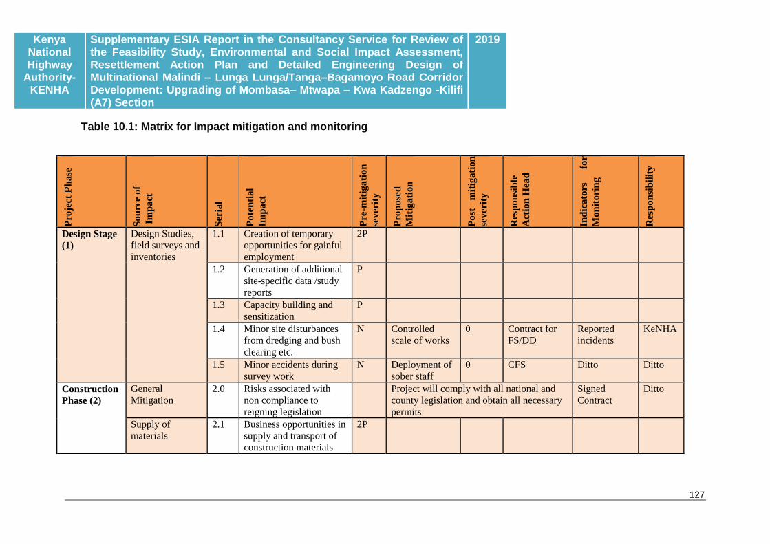
Kenya National Highway
Authority-KENHA
Supplementary ESIA Report in the Consultancy Service for Review of the Feasibility Study, Environmental and Social Impact Assessment, Resettlement Action Plan and Detailed Engineering Design of Multinational Malindi – Lunga Lunga/Tanga–Bagamoyo Road Corridor Development: Upgrading of Mombasa– Mtwapa – Kwa Kadzengo -Kilifi (A7) Section
2019
127
Pro
ject
Ph
ase
Sou
rce
of
Im
pact
Ser
ial
Pote
nti
al
Imp
act
Pre
-mit
igati
on
sever
ity
Pro
pose
d
Mit
igati
on
Post
m
itig
ati
on
sever
ity
Res
pon
sib
le
Act
ion
Hea
d
Ind
icato
rs
for
Mon
itori
ng
Res
pon
sib
ilit
y
Design Stage
(1)
Design Studies,
field surveys and
inventories
1.1 Creation of temporary
opportunities for gainful
employment
2P
1.2 Generation of additional
site-specific data /study
reports
P
1.3 Capacity building and
sensitization
P
1.4 Minor site disturbances
from dredging and bush
clearing etc.
N Controlled
scale of works
0 Contract for
FS/DD
Reported
incidents
KeNHA
1.5 Minor accidents during
survey work
N Deployment of
sober staff
0 CFS Ditto Ditto
Construction
Phase (2)
General
Mitigation
2.0 Risks associated with
non compliance to
reigning legislation
Project will comply with all national and
county legislation and obtain all necessary
permits
Signed
Contract
Ditto
Supply of
materials
2.1 Business opportunities in
supply and transport of
construction materials
2P
Table 10.1: Matrix for Impact mitigation and monitoring

Kenya National Highway
Authority-KENHA
Supplementary ESIA Report in the Consultancy Service for Review of the Feasibility Study, Environmental and Social Impact Assessment, Resettlement Action Plan and Detailed Engineering Design of Multinational Malindi – Lunga Lunga/Tanga–Bagamoyo Road Corridor Development: Upgrading of Mombasa– Mtwapa – Kwa Kadzengo -Kilifi (A7) Section
2019
128
2.2 Road hazards in material
transportation
N Deploy sober,
disciplined,
well supervised
drivers
N Contract for
Works
Reported
incidents
KeNHA
through
Contract
for
Services
2.3 Degradation along
material sourcing and
transport
2N Source from
NEMA audited
quarries or
undertake EIA
for target
quarries
N Ditto EIA Licences
for new
quarries
Ditto
2.4 Carbon footprint in the
transportation of
construction materials
N Reduced
distances
covered in
material
transport
N Ditto Approved
Contractor’s
Report
Ditto
2.5 Introduction of invasive/
alien species in
construction materials
2N Participatory
pre-screening
of target
materials
N Ditto Screening
Report
Ditto
Construction
Activities
2.6 Short-term opportunities
for business and
employment
2P
2.7 Revenue sources to GoK
and County
Governments
P
2.8 Opportunity for change P
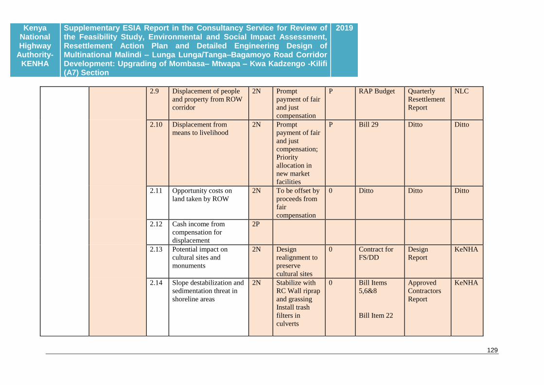
Kenya National Highway
Authority-KENHA
Supplementary ESIA Report in the Consultancy Service for Review of the Feasibility Study, Environmental and Social Impact Assessment, Resettlement Action Plan and Detailed Engineering Design of Multinational Malindi – Lunga Lunga/Tanga–Bagamoyo Road Corridor Development: Upgrading of Mombasa– Mtwapa – Kwa Kadzengo -Kilifi (A7) Section
2019
129
2.9 Displacement of people
and property from ROW
corridor
2N Prompt
payment of fair
and just
compensation
P RAP Budget Quarterly
Resettlement
Report
NLC
2.10 Displacement from
means to livelihood
2N Prompt
payment of fair
and just
compensation;
Priority
allocation in
new market
facilities
P Bill 29 Ditto Ditto
2.11 Opportunity costs on
land taken by ROW
2N To be offset by
proceeds from
fair
compensation
0 Ditto Ditto Ditto
2.12 Cash income from
compensation for
displacement
2P
2.13 Potential impact on
cultural sites and
monuments
2N Design
realignment to
preserve
cultural sites
0 Contract for
FS/DD
Design
Report
KeNHA
2.14 Slope destabilization and
sedimentation threat in
shoreline areas
2N Stabilize with
RC Wall riprap
and grassing
Install trash
filters in
culverts
0 Bill Items
5,6&8
Bill Item 22
Approved
Contractors
Report
KeNHA

Kenya National Highway
Authority-KENHA
Supplementary ESIA Report in the Consultancy Service for Review of the Feasibility Study, Environmental and Social Impact Assessment, Resettlement Action Plan and Detailed Engineering Design of Multinational Malindi – Lunga Lunga/Tanga–Bagamoyo Road Corridor Development: Upgrading of Mombasa– Mtwapa – Kwa Kadzengo -Kilifi (A7) Section
2019
130
2.15 Inconveniences to road
users through blockage
and diversion of traffic
N Regulate
number of
concurrent
blockages and
diversions
N Bill Item 9 Ditto KeNHA
2.16 Input of contaminated
runoff and sediment into
shoreline
N N Bill Item 8 Ditto Ditto
2.17 Loss of carbon sinks in
destroyed cover
vegetation
N Reforestation
to establish
cover of
displaced trees
0 This ESMP
Bill Item 20
Ditto KeNHA
2.18 Destruction of
biodiversity held in
undisturbed sites
N Topsoil to be
recovered for
use in re-
grassing
0
2.19 Destruction of the
Kadzengo habitat for
avian biodiversity
N Minimize
conversion and
maintain
current
hydrological
regime
0 Bill Item 8 Ditto Ditto
2.20 Risk of fire hazards
during construction
N Implement the
Contractors
Code
N Bill Item 1 Ditto Ditto

Kenya National Highway
Authority-KENHA
Supplementary ESIA Report in the Consultancy Service for Review of the Feasibility Study, Environmental and Social Impact Assessment, Resettlement Action Plan and Detailed Engineering Design of Multinational Malindi – Lunga Lunga/Tanga–Bagamoyo Road Corridor Development: Upgrading of Mombasa– Mtwapa – Kwa Kadzengo -Kilifi (A7) Section
2019
131
2.21 Nuisances-dust, fumes,
vibrations from operation
of plant and equipment
2N Optimise on
operation time
to shorten
disturbance
period; wet
curing to
control dust
N Bill Item 1 Ditto Ditto
2.22 Social and health hazards
of construction crew and
labour camps
N Local sourcing
of labour;
continuous
sensitization
and counselling
N Bill Item 1
Campaign on
Awareness,
prevention
and training
Ditto Ditto
2.23 Sanitation concerns from
construction crew
N Provide
adequate
gender
segregated
restrooms at
construction
sites.
0 Bill Item 1 Ditto Ditto
2.24 Occupational health and
safety concerns for
construction crew
N Deploy sober,
competent and
supervised
staff. Provide
PPEs
N Bill Item 1 Ditto Ditto
2.25 Disruption of existing
infrastructure (water
mains, power
transmission and data
cables)
N Relocation and
improve
services prior
to ground-
breaking
P Bill Items
1&27
Ditto Ditto

Kenya National Highway
Authority-KENHA
Supplementary ESIA Report in the Consultancy Service for Review of the Feasibility Study, Environmental and Social Impact Assessment, Resettlement Action Plan and Detailed Engineering Design of Multinational Malindi – Lunga Lunga/Tanga–Bagamoyo Road Corridor Development: Upgrading of Mombasa– Mtwapa – Kwa Kadzengo -Kilifi (A7) Section
2019
132
2.26 Disruption of services,
connectivity, ease of
access and normalcy by
construction activity
N Establish
mechanisms for
free flow of
information,
provides viable
alternatives
0 Bill Item 1&9 Ditto Ditto
2.27 Pressure on water
resources
N Contractor to
develop own
sources of
water
P Bill item 1 Ditto Ditto
2.28 Pollution from
construction waste,
waste oils and spares
N Waste recovery
for recycling,
reuse and sale
P Bill Item 1 Ditto Ditto
Operation
Phase (3.0)
Operation of the
completed
highway
3.1 Benefits from
decommissioned
contractor camps and
facilities
2P
3.2 Provision of a functional
and efficient road
connection through
North Coast
2P
3.3 Aesthetic impacts of a
new highway
2P
3.4 Enhanced quality of life
from improved delivery
of services in Medicare,
education, admin,
telecommunication, etc
2P
3.5 Enhanced passenger and
cargo movement
2P

Kenya National Highway
Authority-KENHA
Supplementary ESIA Report in the Consultancy Service for Review of the Feasibility Study, Environmental and Social Impact Assessment, Resettlement Action Plan and Detailed Engineering Design of Multinational Malindi – Lunga Lunga/Tanga–Bagamoyo Road Corridor Development: Upgrading of Mombasa– Mtwapa – Kwa Kadzengo -Kilifi (A7) Section
2019
133
3.6 Enhanced visitor access
to the North Coast
Tourist attractions
P
3.7 Reduced traffic
congestion and
associated pollution
2P
3.8 Opportunity for self-
employment in public
transport
2P
3.9 Enhanced value of
property along upgraded
road
2P
3.10 Land use change due to
settlements attracted by
new road
N Respective
County
Governments
and Agencies
to plan to
service
provision as per
mandates
P Respective
Internal
budgets
Approved
planning
Reports
Cabinet
Commit
tee on
Plannin
g 3.11 Pressure on resources
and services from
emerging urban
settlements attracted by
the new road
2N P
3.12 Pollution of Tudor and
Mtwapa creeks from
road runoff
2N As for Item
2.16 above
N
3.13 Curtailed access and ease
of crossing the road by
the physical barrier
2N Provision of
adequate
crossing points
N Bill Item 21 Approved
Contractors’
Report
KeNHA

Kenya National Highway
Authority-KENHA
Supplementary ESIA Report in the Consultancy Service for Review of the Feasibility Study, Environmental and Social Impact Assessment, Resettlement Action Plan and Detailed Engineering Design of Multinational Malindi – Lunga Lunga/Tanga–Bagamoyo Road Corridor Development: Upgrading of Mombasa– Mtwapa – Kwa Kadzengo -Kilifi (A7) Section
2019
134
3.14 The hazard of traffic
accidents from speeding
vehicles
2N Provide for
pedestrian
passage and
crossing.
Aggressive
Road Safety
Awareness
Campaign
Provide road
safety
signboards
N Bill
Items11/21
Bill Item 26
Bill Item 20
Ditto Ditto
3.15 Curtailed movement of
reptiles and small
mammals by the road
embankment
2N Provide
culverts
N Bill Items 7/8 Ditto Ditto
3.16 Alteration of local
hydrology and drainage
by paved road surface
2N Provide
adequate
drainage
capacity
N Bill Items 7/8 Ditto Ditto
3.18 Increased noise from
motor vehicles
N Create noise
barriers
through tree
planting
N Bill Item 20 Ditto Ditto
Net environmental worth of the
project pre-mitigation
50 29P (29 positive outputs, mainly
long-term),
47N (47 adverse outputs, 25
long-term, 11 irreversible),
Net score=18N (Net negative
impact before mitigation)
35P (35Positive outputs)
16N (16Negative outputs)
Net Score: 19P Net
Positive effect after
mitigation
Kenya National Highway
Authority-KENHA
Supplementary ESIA Report in the Consultancy Service for Review of the Feasibility Study, Environmental and Social Impact Assessment, Resettlement Action Plan and Detailed Engineering Design of Multinational Malindi – Lunga Lunga/Tanga–Bagamoyo Road Corridor Development: Upgrading of Mombasa– Mtwapa – Kwa Kadzengo -Kilifi (A7) Section
2019
135
N=low negative impact; 2N=moderately severe impact; 0= no impact; P= positive impact, 2P= significantly positive impact
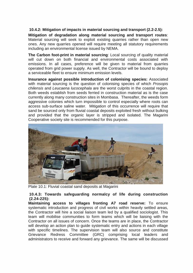
10.4.2: Mitigation of impacts in material sourcing and transport (2.2-2.5):
Mitigation of degradation along material sourcing and transport routes: Material sourcing will seek to exploit existing quarries rather than open new ones. Any new quarries opened will require meeting all statutory requirements including an environmental license issued by NEMA.
The Carbon foot-print in material sourcing: Local sourcing of quality material will cut down on both financial and environmental costs associated with emissions. In all cases, preference will be given to material from quarries operated from grid power supply. As well, the Contractor will be bound to deploy a serviceable fleet to ensure minimum emission levels.
Insurance against possible introduction of colonising species: Associated with material sourcing is the question of colonising species of which Prosopis chilensis and Leucaena lucocephala are the worst culprits in the coastal region. Both weeds establish from seeds ferried in construction material as is the case currently along many construction sites in Mombasa. Thereafter, the weeds form aggressive colonies which turn impossible to control especially where roots can access sub-surface saline water. Mitigation of this occurrence will require that sand be sourced only from fluvial coastal deposits exploited fresh without bulking and provided that the organic layer is stripped and isolated. The Magarini Cooperative society site is recommended for this purpose.
Plate 10.1: Fluvial coastal sand deposits at Magarini
10.4.3: Towards safeguarding normalcy of life during construction (2.24-225): Maintaining access to villages fronting A7 road reserve: To ensure systematic introduction and progress of civil works within heavily settled areas, the Contractor will hire a social liaison team led by a qualified sociologist. This team will mobilise communities to form teams which will be liaising with the Contractor on all issues of concern. Once the teams are in place, the Contractor will develop an action plan to guide systematic entry and actions in each village with specific timelines. The supervision team will also source and constitute Grievance Redress Committee (GRC) comprising local leaders and administrators to receive and forward any grievance. The same will be discussed

Kenya National Highway
Authority-KENHA
Supplementary ESIA Report in the Consultancy Service for Review of the Feasibility Study, Environmental and Social Impact Assessment, Resettlement Action Plan and Detailed Engineering Design of Multinational Malindi – Lunga Lunga/Tanga–Bagamoyo Road Corridor Development: Upgrading of Mombasa– Mtwapa – Kwa Kadzengo -Kilifi (A7) Section
2019
137
and adopted with villagers who will then be prepared to cope with the change. Paramount to these strategies is the following issues:-
i) All compensation will be paid upfront of ground breaking ii) PAP and Locational Elders Committees will be in place long before
ground breaking to handle and resolve disputes emanating from displacement
iii) PAPs will be given adequate notice to relocate property including harvesting of food crops
iv) Where some facility such as water will be blocked entirely, the Contractor will provide alternatives.
v) The Contractor will set up a liaison office within close vicinity to village and urban centres traversed where residents can file complaints.
vi) All construction crew will bear badges with full identification inclusive of photographs.
vii) The contractor will pick and employ security scouts to provide pedestrian access through construction sites.
Minimizing disruption of transport services: At all times, the Contractor will identify and provide alternative access routes, detour roads or diversions to replace those under construction. All such measures will require prior approval by the RE and must be kept to the minimum. At no time will any area be left marooned without any means of access to essential facilities.
Minimizing disruption of existing infrastructure: The entire alignment of Project Road is criss-crossed by a main pipeline from Baricho which supplies Mombasa Mainland North whose displacement could interfere with critical services including water supply to Mombasa City. The Contractor will provide alternative connections prior to displacement of target sections. As well, where sections of the pipeline will be replaced, the aim should be to always replace with better.
10.4.4: Mitigation shoreline sedimentation threat from slope destabilization (2.14/2.16)
Stabilization of wash prone soil: All cut and fill areas will require stabilization with both grass and masonry structures. Soil stabilisation measures will be put in place to prevent soil wash into the creek areas. Towards this,
Civil works will be phased as to avoid seasons of torrential rainfall,
Clearing and stripping will be restricted to the pavement area and all downstream vegetation will be retained intact.
Stuffed gunny bags or other appropriate technology will be deployed to stabilize soil downstream of cut and fill sites.
Stockpiling of soil and building material will avoid slanting ground and all riparian areas,
Kenya National Highway
Authority-KENHA
Supplementary ESIA Report in the Consultancy Service for Review of the Feasibility Study, Environmental and Social Impact Assessment, Resettlement Action Plan and Detailed Engineering Design of Multinational Malindi – Lunga Lunga/Tanga–Bagamoyo Road Corridor Development: Upgrading of Mombasa– Mtwapa – Kwa Kadzengo -Kilifi (A7) Section
2019
138
All stockpiled soil will be ring-guarded from intrusion by runoff
Mitigating chemical pollution into Mtwapa Creek: Towards mitigating impacts of excavation and construction within Mtwapa Creek, the following actions are prohibited:-
Use of any chemical banned from use in Kenya, Use of any chemical that is harmful to marine life, Use of any chemical that persists in the environment or turns harmful
upon contact with water, Blasting in the sea bed, Use of equipment that spill oils into the water.
Use of any chemical within the creek areas will require approval by NEMA in consultation with the Kenya Maritime Authority in capacity of Lead Agency. Additionally, movement of construction equipment into the Creek area will require approval by the KPA, KMA and obtain requisite permits.
10.4.5: Towards mitigating loss of biodiversity
Mitigating loss of floral biodiversity and carbon sink (2.5 /2.18/2.19)
Landscape change through clearing of standing and below ground floral biodiversity will be mitigated a s follows:-
All trees located in the road reserve but outside of pavement area will be left intact,
A reforestation plan will be implemented to replace the 7,592 trees to be displaced by the road and to cater for those to be lost to intensified settlement. Locally active conservation groups will be strengthened to bulk seedlings of locally important trees some of which will be used in road side reforestation and planting on communal sites. An aggressive reforestation and landscaping initiative will be mounted to re-establish cover and tone down impacts of the road. This will call for planting of deep rooting trees that produce high overhanging canopies without undermining the bitumen surface. Examples include Jacarandas, Mango, Cassia spectabilis, Delonix regia, Trichilia roka, Neutonia buchananii, among others. Planting will also extend to stabilize the road reserve and recreate any shoreline mangrove formations that may be displaced.
All top soil stripped from undisturbed sites will be bulked and applied in topsoiling for grassing and filling material borrow sites.
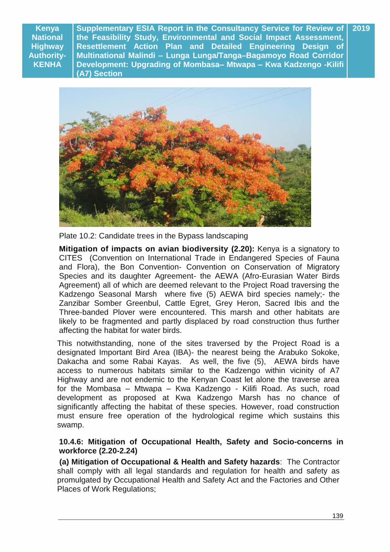
Kenya National Highway
Authority-KENHA
Supplementary ESIA Report in the Consultancy Service for Review of the Feasibility Study, Environmental and Social Impact Assessment, Resettlement Action Plan and Detailed Engineering Design of Multinational Malindi – Lunga Lunga/Tanga–Bagamoyo Road Corridor Development: Upgrading of Mombasa– Mtwapa – Kwa Kadzengo -Kilifi (A7) Section
2019
139
Plate 10.2: Candidate trees in the Bypass landscaping
Mitigation of impacts on avian biodiversity (2.20): Kenya is a signatory to CITES (Convention on International Trade in Endangered Species of Fauna and Flora), the Bon Convention- Convention on Conservation of Migratory Species and its daughter Agreement- the AEWA (Afro-Eurasian Water Birds Agreement) all of which are deemed relevant to the Project Road traversing the Kadzengo Seasonal Marsh where five (5) AEWA bird species namely;- the Zanzibar Somber Greenbul, Cattle Egret, Grey Heron, Sacred Ibis and the Three-banded Plover were encountered. This marsh and other habitats are likely to be fragmented and partly displaced by road construction thus further affecting the habitat for water birds.
This notwithstanding, none of the sites traversed by the Project Road is a designated Important Bird Area (IBA)- the nearest being the Arabuko Sokoke, Dakacha and some Rabai Kayas. As well, the five (5), AEWA birds have access to numerous habitats similar to the Kadzengo within vicinity of A7 Highway and are not endemic to the Kenyan Coast let alone the traverse area for the Mombasa – Mtwapa – Kwa Kadzengo - Kilifi Road. As such, road development as proposed at Kwa Kadzengo Marsh has no chance of significantly affecting the habitat of these species. However, road construction must ensure free operation of the hydrological regime which sustains this swamp.
10.4.6: Mitigation of Occupational Health, Safety and Socio-concerns in workforce (2.20-2.24)
(a) Mitigation of Occupational & Health and Safety hazards: The Contractor shall comply with all legal standards and regulation for health and safety as promulgated by Occupational Health and Safety Act and the Factories and Other Places of Work Regulations;

Kenya National Highway
Authority-KENHA
Supplementary ESIA Report in the Consultancy Service for Review of the Feasibility Study, Environmental and Social Impact Assessment, Resettlement Action Plan and Detailed Engineering Design of Multinational Malindi – Lunga Lunga/Tanga–Bagamoyo Road Corridor Development: Upgrading of Mombasa– Mtwapa – Kwa Kadzengo -Kilifi (A7) Section
2019
140
The Contractor shall provide a standard first aid kit to field staff;
The Contractor shall ensure that staff are made aware of the risks of contracting or spreading sexually transmitted diseases, particularly HIV/AIDS and how to prevent or minimize such risks. Under the Contract there is provision for campaign for HIV/AIDS Awareness, Prevention and Training.
The Contractor shall be responsible for the protection of the public and public property from any dangers associated with construction activities, and for the safe and easy passage of pedestrians and traffic in areas affected by the construction activities;
All works which may pose a hazard to humans and domestic animals are to be protected, fenced, demarcated or cordoned off as instructed by the RE. If appropriate, symbolic warning signs must be erected;
Speed limits appropriate to the vehicles driven are to be observed at all times on access and haul roads. Operators and drivers are to ensure that they limit their potential to endanger humans and animals at all times by observing strict safety precautions;
No unauthorized firearms are permitted on site;
The Contractor shall provide the appropriate Personal Protective Equipment for staff.
(b) Fire Prevention and Control: The Contractor shall take all reasonable and precautionary steps to ensure that fires are not started as a consequence of his activities on site;
i) The Contractor shall ensure that there is basic fire-fighting equipment available on site;
ii) Flammable materials should be stored under conditions that will limit the potential for ignition and the spread of fires;
iii) ‘Hot’ work activities shall be restricted to a site approved by the RE;
iv) Smoking shall not be permitted in those areas where there is a fire hazard. These areas shall include any areas (e.g. park/forest areas) where vegetation or other material is such as to make liable the rapid spread of an initial flame.
v) The Contractor shall ensure that all site personnel are aware of the fire risks and how to deal with any fires that occur. This shall include, but not be limited to regular fire prevention talks and drills and, posting of regular reminders to staff.
vi) Any fires that occur shall be reported to the RE immediately and then to the relevant authorities;
Kenya National Highway
Authority-KENHA
Supplementary ESIA Report in the Consultancy Service for Review of the Feasibility Study, Environmental and Social Impact Assessment, Resettlement Action Plan and Detailed Engineering Design of Multinational Malindi – Lunga Lunga/Tanga–Bagamoyo Road Corridor Development: Upgrading of Mombasa– Mtwapa – Kwa Kadzengo -Kilifi (A7) Section
2019
141
vii) In the event of a fire, the Contractor shall immediately employ such plant and personnel as is at his disposal and take all necessary action to prevent the spread of the fire and bring the fire under control;
viii) Costs incurred through fire damage will be the responsibility of the Contractor, should the Contractor’s staff be proven responsible for such a fire.
(c) Emergency Procedures: The Contractor shall submit Method Statements covering the procedures for the main activities which could generate emergency situations through accidents or neglect of responsibilities. These situations include, but are not limited to: accidents at the work place including wildlife invested areas, accidental fires; accidental leaks and spillages and vehicle and plant accidents. Specific to accidents at work place:
The Contractor shall ensure that his employees are drilled in the procedure for working in protected areas as provided for in Cap 376 and Forests Act of 2005.
He shall make arrangements for KWS to provide armed rangers to accompany employees working in wildlife invested areas,
The Contractor shall also ensure that the necessary equipment for work in hazardous area –protective boots, PPEs, helmets, etc., are provided.
(d) Mitigation of HIV/AIDS: The contractor in consultation with implementing agencies responsible for HIV/AIDS will mount educational campaigns to keep workers sensitized on the reality of this pandemic. He shall monitor activities regularly to assess effectiveness and impact. This should include an initial, interim and final assessment of basic knowledge, attitude and practices taking account of existing data sources and recognizing the limitations due to the short timeframe to show behaviour change. The assessment will be supported by qualitative information from observations on workers behaviour.
(e) Mitigation of Solid Waste: All storage and construction sites are to be kept clean, neat and tidy at all times. No burying or dumping of any waste materials, metallic waste, litter or refuse shall be permitted. The Contractor must adhere to Environmental Management and Co-ordination (Waste Management) Regulations 2006. The Contractor shall implement measures to minimize waste and develop a waste management plan to include the following:-
All personnel shall be instructed to dispose of all waste in a proper manner;
i) At all places of work the contractor shall provide litter collection facilities;
ii) The final disposal of the site waste shall be done at the location that shall be approved by the RE, after consultation with local administration and local leaders;

Kenya National Highway
Authority-KENHA
Supplementary ESIA Report in the Consultancy Service for Review of the Feasibility Study, Environmental and Social Impact Assessment, Resettlement Action Plan and Detailed Engineering Design of Multinational Malindi – Lunga Lunga/Tanga–Bagamoyo Road Corridor Development: Upgrading of Mombasa– Mtwapa – Kwa Kadzengo -Kilifi (A7) Section
2019
142
iii) The provision of sufficient bins (preferably vermin and weatherproof) at the camp and work sites to store the solid waste produced on a daily basis;
iv) Wherever possible, materials used or generated by construction shall be recovered at the conclusion of each task for safe disposal including recycling.
v) Provision for responsible management of any hazardous waste generated during the construction works.
(f) Wastewater and contaminated water management: No grey water runoff or uncontrolled discharges from any site or working areas (including wash-down areas) to adjacent watercourses and/or water bodies shall be permitted;
Water containing such pollutants as cements, concrete, lime, chemicals and fuels shall be discharged into a conservancy tank for removal from site. This particularly applies to water emanating from concrete batching plants and concrete swills;
The Contractor shall also prevent runoff loaded with sediment and other suspended materials from the site/working areas from discharging to adjacent watercourses and/or water bodies;
Potential pollutants of any kind and in any form shall be kept, stored and used in such a manner that any escape can be contained and the water table not endangered;
Wash areas shall be placed and constructed in such a manner so as to ensure that the surrounding areas (including groundwater) are not polluted;
The Contractor shall notify the RE of any pollution incidents on site.
(g) General materials handling, use and storage: All materials shall be stored within the Contractor’s camp unless otherwise approved by the RE;
Stockpile areas shall be approved by the RE;
All imported fill, soil and/or sand materials shall be free of weeds, litter and contaminants. Sources of imported materials shall be listed and approved by the RE;
The Contractor shall ensure that delivery drivers are informed of all procedures and restrictions (including ‘No go’ areas) required;
Any electrical or petrol driven pumps shall be equipped and positioned so as not to cause any danger of ignition of the stored product;
Collection containers (e.g. drip trays) shall be placed under all dispensing mechanisms for hydrocarbons or hazardous liquid substances to ensure no contamination from any leaks is reduced;

Kenya National Highway
Authority-KENHA
Supplementary ESIA Report in the Consultancy Service for Review of the Feasibility Study, Environmental and Social Impact Assessment, Resettlement Action Plan and Detailed Engineering Design of Multinational Malindi – Lunga Lunga/Tanga–Bagamoyo Road Corridor Development: Upgrading of Mombasa– Mtwapa – Kwa Kadzengo -Kilifi (A7) Section
2019
143
Regular checks shall be conducted by the Contractor on the dispensing mechanisms for all above ground storage tanks to ensure faulty equipment is identified and replaced in timely manner;
Only empty and externally clean tanks may be stored on bare ground. All empty and externally dirty tanks shall be sealed and stored on an area where the ground has been protected.
10.5 MITIGATION OF IMPACTS AT OPERATION STAGE
Proposed mitigation activities at this stage are focused on minimizing hazards associated with commissioning and operation of a modern road. Action will take place at diverse levels namely:-
10.5.1: Mitigating impacts of land use conversion and commercialization (3.10/3.11): Mitigation here will require that responsible GOK Agencies mainly County Governments to put in place zoning plans for purposes of regulating development followed by formulation of master-plans and budgets to guide and support service provision.
10.5.2: Pollution of Tudor and Mtwapa Creeks from road runoff (3.13): This EIA study has consulted extensively on the question of pollution threat posed to the Creeks by vehicles using the proposed new bridge over Mtwapa, Mtopanga and Bongolo drainages whereby the common opinion is that oil leaks from moving vehicles are quite limited in extent. Further, given that the new Mtwapa Bridge will be hardly 500metres, the amount of oil leak correcting from such a small catchment area will be quite limited as to pause any real pollution threats. Thus, so long as vehicles will not be allowed to stall and undergo repairs over the bridges, this threat can be ignored. The exception however is the weighbridge where on account of long residency time taken by vehicles queuing to weigh, threats of oil leaks are real and the same will require mitigation through filtration of any runoff emergent from the weighbridge station.
10.5.3: Mitigation of curtailed movement across the Highway (3.14): Once commissioned, the road will impose some barriers to free movement and access. Appropriate and adequate crossing for people and their livestock should be provided both for high- and low-density settlements. A total of 28 crossings will be provided at all road intersections and for intervals where such intersections are more than 250m apart.
10.5.4: Mitigation of traffic accidents (3.16): All dualed road sections across densely settled areas will be fitted with barriers to keep off people and livestock crossing in undesignated areas. An aggressive public sensitisation campaign will be mounted to create awareness of threats posed by the new road. Designated areas for crossing on dual road section will be provided. Between Kwa Kadzengo and Kilifi where the road is single carriageway, the road has adequate underpasses for livestock. However, should need arise for additional such underpasses they will be provided

Kenya National Highway
Authority-KENHA
Supplementary ESIA Report in the Consultancy Service for Review of the Feasibility Study, Environmental and Social Impact Assessment, Resettlement Action Plan and Detailed Engineering Design of Multinational Malindi – Lunga Lunga/Tanga–Bagamoyo Road Corridor Development: Upgrading of Mombasa– Mtwapa – Kwa Kadzengo -Kilifi (A7) Section
2019
144
10.5.5: Mitigation of noise and atmospheric pollutants:
According to the Kenyan noise regulations, the noise levels during the day at three sites exceeded the maximum permissible noise level of 50 dB(A) for a residential zone. The noise levels at all five sites during the night exceeded the maximum permissible noise level of 35 dB(A) for residential areas. The future noise levels were calculated based on the projected traffic volume per day on Project Road by year 2030. The prediction point was set at the edge of ROW. The horizontal distance from the centre of the road to the prediction point is 18 meters since ROW is about 37 meters wide. The predicted noise levels at the edge of ROW based on the projected traffic volume all exceed the Kenyan and WHO guidelines for all zones, therefore, abatement measures should be implemented along the roads close to the residential areas, especially schools, hospitals and religious facilities as follows:-
Install noise barriers and low noise pavement
Attach noise absorbing panels under elevated road sections
Set environmental facility zones such as green belt
Install warning signs on road for horn ban, speed control and lane restriction
Regular maintenance on road to keep road surface good condition
Develop a mechanism to record and respond to monitoring results and complaints
10.6: EFFECTIVENESS OF THE MITIGATION PROGRAMME
10.6.1 Viability of Mitigation
Effectiveness of the proposed mitigation programme has been assessed based on analysis of impact prevalence before and after mitigation (Table 10.2) based on this analysis, this Environmental and Social Impact Assessment Study observes that, there is a great potential to mitigate adverse impacts and hence improve the net worth of the proposed road. From Table 10.2, it is apparent that application of mitigation measures as identified and recommended has potential to reduce tally of adverse impacts (Ns) from 47 to 16 while simultaneously increasing the positive ones (Ps) from 29 to 35. Thus, subtracting the Ns from the Ps gives an overall net tally of 19P implying a very positive net impact after mitigation. Sixteen (16) impacts have a residual character with 11 being irreversible, acknowledging that some impacts are irreversible and still persist even after mitigation.
Table 10.2: Analysis of impacts scenario before and after mitigation
Nature of impact Pre-mitigation tally Post-mitigation tally
Positives 29P 35P
Negatives 47N 16N
Net 18N 19P

Kenya National Highway
Authority-KENHA
Supplementary ESIA Report in the Consultancy Service for Review of the Feasibility Study, Environmental and Social Impact Assessment, Resettlement Action Plan and Detailed Engineering Design of Multinational Malindi – Lunga Lunga/Tanga–Bagamoyo Road Corridor Development: Upgrading of Mombasa– Mtwapa – Kwa Kadzengo -Kilifi (A7) Section
2019
145
Residue impacts 16
Irreversible adverse impacts
11 11
10.6.2: Prevalence of residue impacts
This study observes that 10 of the 61 adverse impacts associated with the project will persist even after mitigation. These are the impacts whose probability can be reduced substantially through mitigation but cannot be eliminated entirely. Their management requires implementation of a strict monitoring programme as outlined elsewhere below.
10.6.3 Net worth of the Project
Overall, the proposed project enjoys a highly positive benefits profile as it will strongly support initiatives towards poverty alleviation and reversal of environmental-degradation both of which are critically important policy aspirations of the Kenya Government. This Study recommends that project development should proceed but factor in the mitigation measures recommended herein. Implementation of this ESMP will however require close follow-up and scrutiny to ensure achievement and substance of this esteemed net positive profile of the project. Requirements for monitoring are explored below.
10.7 MANAGEMENT OF DECOMMISSIONING
Several levels of decommissioning are anticipated; -
10.7.1 Decommissioning of Contractor/ Resident Engineer’s Camps
This will take place upon completion and hand over of the road to KeNHA. The proposal by communities for the camps to be handed over to them for alternative use is recommended.
10.7.2 Decommissioning of the Road
Design of roads assumes pavement life of 15 to 20 years which imply that, at some point, the system will require rehabilitation either in whole or by components. Concerns associated with rehabilitation would include occupational health and safety hazards, accumulation of scrap metal waste, which apart from taking up productive space would also pose diverse hazards (health and safety, harbouring of vermin, etc) to local inhabitants and their property. Other impacts would emanate from failure to utilise existing asphaltic layers or concrete materials back to economic use. The ESMP unveiled in sections below has explicit requirements for management of rehabilitation phase impacts.
10.8: THE ENVIRONMENTAL AND SOCIAL MONITORING PLAN

Kenya National Highway
Authority-KENHA
Supplementary ESIA Report in the Consultancy Service for Review of the Feasibility Study, Environmental and Social Impact Assessment, Resettlement Action Plan and Detailed Engineering Design of Multinational Malindi – Lunga Lunga/Tanga–Bagamoyo Road Corridor Development: Upgrading of Mombasa– Mtwapa – Kwa Kadzengo -Kilifi (A7) Section
2019
146
10.8.1: Overview of the ESMP
Modalities for mitigation of impacts and their phasing are presented in the Environmental Mitigation and Management Plan provided in Table 10.1 above. From Table 10.1, it is apparent that most of the mitigation activity will take place during construction but must be planned for at design stage (this stage) to ensure that such mitigation is incorporated and allocated for in the project design. Thus, the first action in mitigation will be a thorough scrutiny of the Design Report to ensure that the ESMP provided in this report has been fully incorporated and allocated for. Further, all mitigation to be implemented during civil works will be allocated for in the Bills of Quantities and captured in the Contract for Construction. KeNHA will hire a qualified Resident Engineer and other supporting staff to ensure full implementation of contractual tasks in mitigation.
10.8.2 : Feasibility of impact mitigation
Majority of impacts have readily available means for mitigation while some of the negative impacts will acquire positive effects after mitigation. Thus, upon application of the Impact Mitigation Programme, majority of the impacts are dispensed with and the project is likely to achieve an overwhelming net positive effect.
10.8.3 Responsibility for mitigation
As per the ESMP below, responsibility for mitigating impacts of civil works falls on the contractor under the supervision of KeNHA.
10.9: ENVIRONMENTAL AND SOCIAL MONITORING REQUIREMENTS
10.9.1: Terminologies
Environmental monitoring refers to the systematic collection, analysis and interpretation of data on environmental parameters through periodic measurements. Accruing information would facilitate tracking of levels of anticipated impacts and to monitor compliance in implementation of mitigation measures. Through periodic observations, it is possible to detect and remedy previously non-anticipated impacts before they turn catastrophic. Further, through continuous assessment of both the negative and positive benefits of a project, it is possible to determine the net impact (change) emanating from a project and thus determine its worth. Environmental monitoring falls in three categories as follows:-
Baseline studies to document local environmental conditions of the project site. Since project impacts are generated by interaction between local environmental conditions and project activities, a study of baseline conditions facilitates prediction of impacts as already undertaken in Chapters Four to Eight of this ESIA study. The documented baseline

Kenya National Highway
Authority-KENHA
Supplementary ESIA Report in the Consultancy Service for Review of the Feasibility Study, Environmental and Social Impact Assessment, Resettlement Action Plan and Detailed Engineering Design of Multinational Malindi – Lunga Lunga/Tanga–Bagamoyo Road Corridor Development: Upgrading of Mombasa– Mtwapa – Kwa Kadzengo -Kilifi (A7) Section
2019
147
environment also provides a permanent benchmark against which long-term changes due to project activities will be monitored.
Routine measurement of effects through measurements on environmental parameters is undertaken during project implementation and operation so as to detect changes attributed to the project.
Compliance monitoring will be effected through regular review of monitoring returns coupled with independent periodic sampling of environmental parameters and indicators. By evaluating the level of parameters against standards, the supervising authority is able to monitor compliance with regulatory requirements. Surveillance and routine inspections also form part of compliance monitoring.
10.9.2 Requirements of the ‘Impacts monitoring’ programme
A major finding of this study is that, potential impacts are largely modest but, upon implementation of an impact mitigation programme as outlined, it is possible to entirely neutralise the bulk of impacts and tone down others. What is however essential is the implementation of an effective compliance monitoring scheme in order to ensure adherence to the mitigation program so as to maintain impacts at the low severity level which calls for a comprehensive compliance monitoring programme.
Table 10.1 provides an M&E matrix for the Project Road with a full complement of criteria and indicators. In addition to specification of impacts and required mitigation activities, the plan also identifies key players in each activity and the recommended timing of interventions. The Environmental and Social Action Plan for the Roads Project also essentially constitutes its compliance monitoring program. Key features of the compliance monitoring programme are as follows:-
The Monitoring Authority: The burden of implementing impact mitigation will fall on the Project Contractor under supervision by KeNHA in the capacity of Employer. Through the Resident Engineer, KeNHA will monitor activities of the Contractor to ensure compliance with contractual requirements including implementation of this ESMP. Where issues not anticipated in this report do arise, the RE will notify KeNHA for action.
Need for NEMA to participate in Site Meetings: NEMA is the body charged under Cap 387 with overall coordination of environmental management in Kenya. While NEMA coordinates this by regulating the ESIA process for projects, there is need for NEMA to follow-up further on implementations of ESMPs as prepared for this project. This ESMP therefore, recommends that the County Environmental Officers for Mombasa and Kilifi be invited to attend regularly site meetings for this project with the Resident Engineer and the Contractor and be facilitated to attend the same under the project. By being represented in site meetings, NEMA will enjoy an excellent opportunity to monitor implementation of the ESMP and to keep track on any emerging issues.

Kenya National Highway
Authority-KENHA
Supplementary ESIA Report in the Consultancy Service for Review of the Feasibility Study, Environmental and Social Impact Assessment, Resettlement Action Plan and Detailed Engineering Design of Multinational Malindi – Lunga Lunga/Tanga–Bagamoyo Road Corridor Development: Upgrading of Mombasa– Mtwapa – Kwa Kadzengo -Kilifi (A7) Section
2019
148
10.9.4 Monitoring Reports
A number of monitoring reports will be developed as follows:
(i) ESIA Study Report under Cap 387: This ESIA Study Report as currently prepared provides a documentation of the baseline environment of the area traversed by the proposed road to be upgraded and the adjoining areas, and thus provides a useful datum against which future monitoring can take place. The ESIA Study Report also includes a project-specific ESMP detailing the means for mitigating identified impacts. It therefore lays the basis for monitoring.
(ii) Annual Audit Reports: The Project Road will be subjected to an annual environmental audit in line with Cap 387. The report will include a summary of the environmental performance of the facility/enterprise vis-à-vis the Environmental Management Plan prepared and, a synthesis of Emergent Concerns.
(iii)Signed minutes of Site Meetings: Following every site meeting, minutes of deliberations will be produced by the SOW, confirmed, signed and adopted as a basis for following up on Contractor’s activity.
10.9.4 Costs in implementing the ESMP
A sum of Kshs. 3,312,742,369 will be required in environmental and social mitigation as detailed in Table 10.3 below. Of this, land acquisition will account for 97.9% as illustrated below.

Table 10.3: Costs in Environmental and Social Mitigation for Project Road
Activity group Item Unit Unit Cost
Total Units
Cost to Item Remarks
Stakeholder Sensitization
Leaders meetings (Msa and Kilifi)
No 140000 12 1,680,000 Three per year in Mombasa and Kilifi
Social Mitigation
Public Hearing meetings
No 25000 72 1,800,000 Twelve meetings repeated twice per year for three years
HIV/AIDS campaign lump sum 4,500,000 To cater for VCT, posters, seminars, resource personnel etc
Land acquisition and RAP implementation
lump sum 3,242,915,769 See separate RAP Report
Community sensitization meetings and seminars
No 86000 72 6,192,000 Twelve meetings repeated twice per year for three years
Mobile toilets No 120,000 24 2,880,000 Gender segregated to be deployed at every working site
OHS Concerns PPEs for workers No (Worker)
2750 500 1,375,000 To cater for boots, mufflers, dust masks, reflectors and apron for each worker
Seminar for workers No 35000 90 3,150,000 To sensitize on workers especially foreign contractor workers on inter community relationships
Preparation of an operations manual
Lump sum
550,000 To be prepared by the RE but costs will cater for review meetings and printing.
Environmental mitigation
Grassing ha 10 1930000 19,300,000 To cater for top soiling, manuring and grassing of cut and fill areas
Reforestation No 1200 3860 14,899,600 To cater for tree planting and beautification on either side of the road
Environmental assessment
EIA for campsites and borrow areas
No 450000 30 13,500,000 NEMA requires standalone EIAs for borrow areas and campsites
Gross budget for implementing the ESMP 3,312,742,369

CHAPTER ELEVEN: CONCLUSION AND RECOMMENDATIONS 11.1: THE PROJECT
The Government of the Republic of Kenya, through its implementing agency, the Kenya National Highways Authority (KeNHA) and support of the African Development Bank (AfDB) is Dualling the Mombasa – Mtwapa – Kwa Kadzengo and upgrading Kwa Kadzengo - Kilifi Section of the Multinational A7 Highway. Towards this, KeNHA has commissioned a Consultancy Study to Review the Feasibility Study, Environmental and Social Impact Assessment, Resettlement Action Plan and Detailed Engineering developed under auspices of the wider Multinational Malindi – Lunga Lunga/Tanga–Bagamoyo Road Corridor Development.
As part of the contract, and in line with existing national legislation and international practice, the Consultant is expected to undertake Review of the Environmental and Social Impact Assessment (ESIA) Report previously prepared for the wider Project as specified in the Terms of Reference. This Report highlights salient social and environmental issues associated with the design, construction and operational aspects of the Project. The Report has been prepared under contract by Lead Experts from Repcon Associates, an Environmental Firm of Experts duly registered and licensed by NEMA (NEMA Registration No. 0002) and other Government of Kenya (GoK) agencies.
11.2: SCOPE OF THE ESIA STUDY
The ESIA Study covers the alignment of the proposed road in Mombasa and Kilifi counties details of which are outlined in Chapter Two of this Report. Detailed scope of the ESIA is captured in the TORs for the Broader Study as follows:-
i) Detailed engineering design through all necessary data collection, field surveys and analysis to cover all aspects of detailed design; including consideration of alternative routes and pavement options, road safety and land acquisition,
ii) Environmental and Social Impact Assessment (ESIA) in accordance with Kenyan legislation, NEMA guidelines; and AfDB guidelines for Integrated Social Safeguards (ISS).
iii) RAP Report to be in line with the current status of the road to ensure all issues regarding ROW are addressed. Prepare a full Resettlement Action Plan (RAP) and associated surveys to identify and value of property that will be affected by the road upgrading works along the road reserve
iv) Carrying out of gender analysis in relation to the proposed project as outlined in the detailed Terms of Reference.
v) Design of geometrics and pavement and all other aspects of the design in accordance with the applicable Kenyan Road Design Manuals and current international engineering practices
This report is in respect of TOR Item No 11.2(ii) above.

Kenya National Highway
Authority-KENHA
Supplementary ESIA Report in the Consultancy Service for Review of the Feasibility Study, Environmental and Social Impact Assessment, Resettlement Action Plan and Detailed Engineering Design of Multinational Malindi – Lunga Lunga/Tanga–Bagamoyo Road Corridor Development: Upgrading of Mombasa– Mtwapa – Kwa Kadzengo -Kilifi (A7) Section
2019
151
11.3: STUDY METHODOLOGY
The ESIA Report previously prepared for Multinational Malindi – Lunga Lunga Road was reviewed against set standards namely:-
Kenyan Standards: EMC(A) 2015 and LN 101 of 2003 (of EMCA); other Kenyan legislation.
AfDB Standards: Operational Safeguards for Integrated Social Safeguards (ISS).
Other standards (World Bank)
Upon review of the existing ESIA Report, a full Supplementary ESIA Study was mounted to bridge all existing gaps. The decision to mount full supplementary ESIA Study was informed by findings that:-
The EIA License previously issued for the Multinational Malindi – Lunga Lunga Road had lapsed and hence required to be updated.
From gap-analysis undertaken of Malindi - Lunga Lunga ESIA process, it emerged that the ESIA Process, ESMP and attendant EIA Licence cannot adequately secure sustainable environmental and social management for the proposed dualling of the Mombasa – Mtwapa – Kwa Kadzengo and upgrading of Kwa Kadzengo - Kilifi (A7)road sections inclusive of the proposed second Mtwapa Bridge. Other reasons that would warrant a full cycle study include the following:-
Existence of culturally sensitive sites: The section of the A7 highway targeted for upgrading traverses several sites of cultural interest including the Kisauni Bell Tower (Kengeleni Tower) gazetted as a National Monument by the NMK since 1983, the Frere Town Community Church among others which required clear mapping for preservation as part of the ESIA process.
Existence of ecologically sensitive sites: Sites that required focused attention during the ESIA process include the Bamburi Forest Block and its Haller Park, the Mtwapa Creek Ecosystem, seasonal marshlands such as Kwa Kadzengo, water courses such as Mtopanga, Bongolo among others. Kwa Kadzengo marshland later turned out to be a habitat for 5 AEWA Bird Species.
Drainage challenges: On account of a largely flat, sometimes internally draining topography, the entire A7 highway section from Kongowea through Mtwapa Bridge to Kwa Kadzengo suffers a huge drainage problem which spills over into sections such as Nyali and Bombululu Estates.
The Question of economic displacement: The A7 Road between Mombasa and Mtwapa is an Economic Corridor hosting many citizens who derive livelihoods through trading in the reserve of the A7 Highway and their potential displacement in road upgrading is currently a major concern.

Kenya National Highway
Authority-KENHA
Supplementary ESIA Report in the Consultancy Service for Review of the Feasibility Study, Environmental and Social Impact Assessment, Resettlement Action Plan and Detailed Engineering Design of Multinational Malindi – Lunga Lunga/Tanga–Bagamoyo Road Corridor Development: Upgrading of Mombasa– Mtwapa – Kwa Kadzengo -Kilifi (A7) Section
2019
152
As well, Mtwapa is a residential Town which houses labour for Mombasa Town and the latter is transported through the A7 Road. Any disruption in passenger transport is likely to cause economic shocks in Mombasa.
Given these considerations, a study process culminating in a Supplementary ESIA Study Report was conceived and implemented in Line with Cap 387 and its tools.
11.3: FINDINGS OF THE STUDY
Based on impact prediction and scoping tools, potential impacts from proposed road upgrading and operation have been predicted and analysed with outcome as tabulated below followed by brief highlights.
Positive impacts: Positive impacts of the road will accrue from provision of an expanded functional road linkage linking Kenya’s North Coast to Mombasa. Further, provision of grade separated interchanges will smoothen traffic flow, eliminate snarl ups and thus drastically cut down on time wasted in the transport of both goods and passengers.
Essentially, the new road will decongest Kongowea, Bombululu and Mtwapa Centres thus making it comfortable for local inhabitants including traders.
Adverse impacts: The most salient observation from this study is that, expansion of the Mombasa – Mtwapa – Kwa Kadzengo - Kilifi (A7) Section to minimum of 37metre wide corridor will entail land acquisition and in the process, will displace people from land, property, business premises and shelter.
Once completed, the road will create physical barriers to pedestrian movement and access within the traverse and will experience threats of accidents to people and road users. Heavy traffic along the new road is likely to escalate noise levels which already exceed statutory limits and could contribute pollution runoff into the Tudor and Mtwapa Creeks.
11.4: THE ENVIRONMENTAL AND SOCIAL MANAGEMENT PLAN (ESMP)
The core outcome of the ESIA Study is an ESMP developed to guide resolution of adverse impacts occasioned by development of the road project. The ESMP comprises four core elements namely:- the Impact Mitigation Plan, the Monitoring Plan, a budget for implementation and modalities for institutional coordination and role play.
The core mitigation strategy in the project was to review and adopt a route alignment that served to avoid, reduce and manage environmental and social concerns as follows:-
Restriction of expansion of the Mombasa – Mtwapa – Kwa Kadzengo road section to a about 37m wide corridor down from the 60m proposed earlier on. This single move cut down land acquisition from 56.16 to 19 hectares

Kenya National Highway
Authority-KENHA
Supplementary ESIA Report in the Consultancy Service for Review of the Feasibility Study, Environmental and Social Impact Assessment, Resettlement Action Plan and Detailed Engineering Design of Multinational Malindi – Lunga Lunga/Tanga–Bagamoyo Road Corridor Development: Upgrading of Mombasa– Mtwapa – Kwa Kadzengo -Kilifi (A7) Section
2019
153
with the tally of potentially displaced PAPs dropping from 3566 to 1894; equivalent to 53.1% of original displacement.
Comparative analysis of displacement from the 60 and 37m wide corridor options
Parcels Hectares Structures PAPs Parcels Hectares Structures PAPs
Mombasa 13.5 364 42.56 301 2533 255 15.2 295 1531
Kilifi 42.6 211 11.6 209 1033 123 3.8 93 363
Totals 56.1 575 54.16 510 3566 378 19 388 1894
% of original 65.7 35.1 76.1 53.1
Displacement by at 37m wide ROWCounty Road length
(Km)
Potential displacement by a 60m ROW
Restriction of the upgrading of the Kwa Kadzengo - Kilifi Section to within the existing road reserve save for Bongolo Bridge approaches reduced displacement and attendant land acquisition to negligible levels.
Selection of a design option that will preserve the Kengeleni Tower and Frere Community Church both of which are physical cultural assets.
To the largest extent possible, the strategy and action plan in formulating the ESMP is to prevent impact occurrence, then move to mitigate inevitable occurrence, a position secured by ensuring that recommendations made herein are incorporated into and influence final outcome of the project design process in which case, the latter process also becomes part of the mitigation programme. In pursuit of this strategy, all mitigation will be sealed at Detailed Design Stage by adopting measures as follows:-
The Environmental and Social Management Plan unveiled in Chapter Twelve below will be integrated into the Final Design Report as a standalone chapter and also to moderate design decisions
The same will be provided for in the BOQs to ensure funding allocation for environmental and social mitigation
Clauses binding parties to affirmative action on the ESMP will be integrated into Contracts for Construction to ensure that the Contractor is legally bound to implement impact mitigation.
The burden of mitigation largely lies with the Project Contractor under supervision by KeNHA through the Resident Engineer. Key observations are that, most adverse impacts are short-term and will disappear once civil works ends while residual impacts will require careful monitoring and coordination with relevant Lead Agencies. A sum of Kshs 3,312,742,369 will be required in environmental and social mitigation of which, 97.7% will go to land acquisition with the rest being available to the Contractor for purposes of environmental restitution. The core monitoring strategy for this project will be through site meetings, in which case, it is recommended that respective County Environmental Coordinators for Mombasa

Kenya National Highway
Authority-KENHA
Supplementary ESIA Report in the Consultancy Service for Review of the Feasibility Study, Environmental and Social Impact Assessment, Resettlement Action Plan and Detailed Engineering Design of Multinational Malindi – Lunga Lunga/Tanga–Bagamoyo Road Corridor Development: Upgrading of Mombasa– Mtwapa – Kwa Kadzengo -Kilifi (A7) Section
2019
154
and Kilifi be invited to such meetings. Other stakeholders such as the County Labour Officer should also initially attend such meetings to ascertain that measures towards securing the health and safety of workers have been put in place. When completed, the Road Project will be subject to statutory environmental and quality audits during the Defect Liability Period and the Contractor will be liable to repair all defects including those pertaining to environmental mitigation.
Overall, it is the impression of this study that, the proposed road upgrading project is a major economic undertaking to which national and regional development targets are tied. It is a vital transport artery and, subject to adoption of mitigation measures and proposal made herein, it should be supported by all.
11.5: RECOMMENDATION Through this Supplementary ESIA Study Report, the Kenya National Highway Authority (KeNHA) through the Director General - the proponent - wishes to disclose that the proposed upgrading of the Mombasa – Mtwapa – Kwa Kadzengo - Kilifi (A7) Road Section has impacts that can readily be mitigated and managed. The majority of adverse impacts identified are of a short-term nature and will cease once the civil works phase is completed. Further, other impacts can be contained through effective planning and management using available means of mitigation. By such disclosure, the prayer of the client to NEMA is for the project to be granted environmental licensing.

Kenya National Highway
Authority-KENHA
Supplementary ESIA Report in the Consultancy Service for Review of the Feasibility Study, Environmental and Social Impact Assessment, Resettlement Action Plan and Detailed Engineering Design of Multinational Malindi – Lunga Lunga/Tanga–Bagamoyo Road Corridor Development: Upgrading of Mombasa– Mtwapa – Kwa Kadzengo -Kilifi (A7) Section
2019
155

Kenya National Highway
Authority-KENHA
Supplementary ESIA Report in the Consultancy Service for Review of the Feasibility Study, Environmental and Social Impact Assessment, Resettlement Action Plan and Detailed Engineering Design of Multinational Malindi – Lunga Lunga/Tanga–Bagamoyo Road Corridor Development: Upgrading of Mombasa– Mtwapa – Kwa Kadzengo -Kilifi (A7) Section
2019
156
APPENDICES (VOLUME TWO) Appendix 1.1 Terms of Reference (TOR)
Appendix 1.2 Curriculum Vitae (CV) of Key Staff for the ESIA Study
Appendix 1.3 World Bank Checklist
Appendix 5.1 Laboratory Test Analysis of Air Quality and Noise
Appendix 6.1 Questionnaire for Socio-Economic Survey
Appendix 6.2 Summary of Floral Diversity
Appendix 6.3 Botanical Inventory
Appendix 6.4 List of Birds Recorded
Appendix 8.1 Pre-Feasibility Stage Consultations
Appendix 10.1 Standard Specification Clauses Supporting ESMP