Embed Size (px)
Citation preview
MAX Station OptimizationConsolidating four MAX Stations in Downtown Portland
1
Contents Context & Background ................................................................................................................................. 3
The Portland Metropolitan Region is Growing ........................................................................................ 3
MAX Blue Line History .............................................................................................................................. 4
Jobs & Housing Access with an Equity Lens ............................................................................................ 5
Part of a Regional Focus on Transit Speed and Reliability ..................................................................... 6
Best Practices: Stop Spacing for Travel Time and Convenience ............................................................ 7
The Proposal and Decision Criteria ............................................................................................................. 9
Criteria: Proximity .................................................................................................................................. 10
Criteria: Access & Coverage.................................................................................................................... 15
Criteria: Safety ........................................................................................................................................ 18
Criteria: Ridership .................................................................................................................................. 18
Impact to Remaining Stations ................................................................................................................... 19
Dwell Times ............................................................................................................................................ 19
Providence Park ................................................................................................................................. 19
Pioneer Courthouse Square ............................................................................................................... 20
Old Town/Chinatown ......................................................................................................................... 21
Platform Capacity .................................................................................................................................. 21
Pioneer Square South ........................................................................................................................ 23
Pioneer Square North ........................................................................................................................ 24
Accessibility Considerations .................................................................................................................. 24
Kings Hill/SW Salmon St. ................................................................................................................... 25
Mall/SW 5th Ave. & Mall/SW 4th Ave. .................................................................................................... 25
Skidmore Fountain ............................................................................................................................. 25
Outreach & Engagement: ........................................................................................................................... 26
Web Page ................................................................................................................................................ 26
Public Notice .......................................................................................................................................... 26
News Release .......................................................................................................................................... 26
Twitter .................................................................................................................................................... 26
Facebook ................................................................................................................................................ 26
Presentations or Conversations ............................................................................................................ 26
Outreach Events ..................................................................................................................................... 28
2
Street Events .......................................................................................................................................... 28
Surveys ................................................................................................................................................... 28
Recommendation and Conclusion ............................................................................................................ 31
Appendices ................................................................................................................................................. 33
Appendix A – Outreach & Engagement Data ......................................................................................... 34
Appendix B – Title VI Equity Analysis ..................................................................................................... 35
Appendix C – Systems Engineering Report ........................................................................................... 36
3
Context & Background
The Portland Metropolitan Region is Growing In 2016, Metro developed a new population forecast for the Portland Metropolitan Region. This forecast anticipates an additional 1.1 million people moving to the area in the next 40 years, pushing the region over the 3 million population mark.1 Additional population will ask more of our infrastructure. If transit were able to serve the same destinations with reduced travel times, literature and recent experience indicates we could attract additional riders.
As population grows, so does traffic congestion. The Oregon Department of Transportation (ODOT) noted in a 2016 report that daily vehicle hours of delay has increased by 22.6 percent just between the years of 2013 and 2015.2 A 2018 INRIX study estimated that the average Portland driver spends 50 hours a year stuck in traffic at an economic toll of $1,648 per driver and a loss to the region’s economy of $3.9 billion a year.3 The hardest hit by congestion and delay are low income and minority communities who, due to increasing housing costs, have been pushed farther away from the central city and key regional employment centers. For all commuters, congestion represents time away from family, wasted fuel, lost productivity and reduced economic competitiveness.
One of the most consistent messages TriMet hears when it asks non-riders why they do not ride, or asks current riders what would cause them to ride more, is the need to increase the convenience and speed of the system. Improving both speed and convenience can sometimes be challenging because speed can be achieved by providing fewer stops, but convenience often means putting stops more closely together. The goal in designing the best transit system is to find the right balance between speed and convenience to maximize ridership and serve community needs.
Light rail lines, with their dedicated right of way and high-capacity vehicles, are uniquely designed to carry many passengers through congested areas quickly and efficiently, and at a regional scale. Station spacing on light rail lines, therefore, reflects this unique role, with stops typically spaced at ¼ mile (1,320 feet) or greater increments. While some customers may walk farther to a MAX station than to a bus stop, they get the advantage of moving through traffic more quickly than on buses. If the light rail train is not moving quickly, the value of the investment in dedicated right-of-way and high capacity trains is lost or significantly eroded.
This analysis was undertaken to examine whether the existing spacing of light rail stations on the system has achieved the optimal balance between speed and convenience, and whether improvements could be achieved that would provide benefits to the overall system without undue burden on current customers.
1 Metro Research Center, Population Forecast to 2060, https://www.oregonmetro.gov/sites/default/files/2016/07/01/MSAPopForecastData.pdf 2 Oregon Department of Transportation, Portland Region 2016 Traffic Performance Report, https://www.oregon.gov/ODOT/Regions/Documents/Region1/2016_TPR_FinalReport.pdf 3 http://inrix.com/scorecard/
4
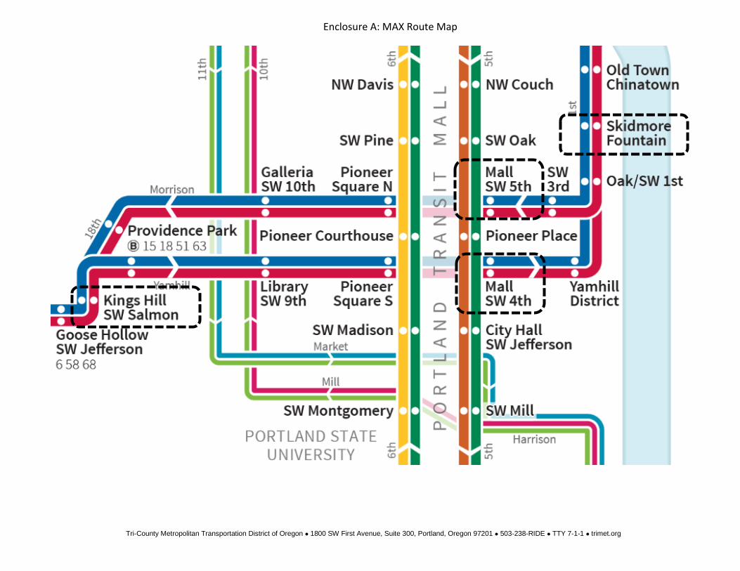
In selecting areas to examine, TriMet focused on downtown where stations are most closely spaced. Currently there are four stations in the TriMet system that are 500 feet or less from an adjacent station: Kings Hill/SW Salmon St., Skidmore Fountain, Mall/SW 4th Ave., and Mall/SW 5th Ave. All of these stations are on the original MAX Blue Line, which was designed and constructed in the relatively early days of light rail development in North America, before optimal station spacing was as well understood as it is today.
An informal survey of rail systems found that no other city in North America has stations that are as close, or closer, to another station as these four. Indeed most transit stations in North America are at least ½ mile apart to balance speed and accessibility. Even Portland Streetcar, which serves much more of a local circulator function, has only one station that is within 500 feet of an alternative. And TriMet’s bus system, with more than 6,600 stops has fewer than seven-percent of stops within 500 feet of an alternative.
Because of these factors, TriMet elected to examine whether the consolidation of these stations with nearby alternatives would help optimize the balance of speed and convenience in the system.
MAX Blue Line History All of the stations being considered for consolidation were planned and constructed as part of the original MAX Blue Line Light Rail System, during the early days of light rail development in North America, and before optimal station spacing was as well understood as it is today. The Mall Stations – Mall/SW 4th Ave. and Mall/SW 5th Ave. – as well as the Skidmore Fountain Station were built as a part of the Eastside MAX Light Rail Project that was constructed between March 1982 and August 1986.
The Kings Hill/SW Salmon St. Station was built as a part of the Westside MAX Blue Line Light Rail extension that was constructed between 1993 and 1998.
Since the opening of Westside MAX, when riders first began to use the light rail for trips through downtown, and as the system grew to serve more uses, complaints began to arise that the stop spacing downtown was not worthy of the name “Metropolitan Area Express” as some can walk faster than the train. An example is captured below.
“…Has there been any discussion about reducing the number of stops on the route? I find the 4 stops within 6 blocks downtown perplexing as I often get off and walk to the Orange Line and beat the train I just got off…” 4
4 Rider Submission to TriMet Service Improvement Process. SIP #530975
5
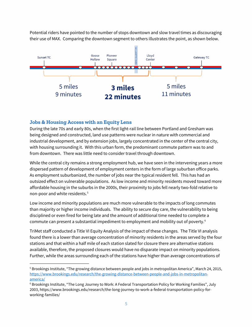
Potential riders have pointed to the number of stops downtown and slow travel times as discouraging their use of MAX. Comparing the downtown segment to others illustrates the point, as shown below.
Jobs & Housing Access with an Equity Lens During the late 70s and early 80s, when the first light-rail line between Portland and Gresham was being designed and constructed, land use patterns were nuclear in nature with commercial and industrial development, and by extension jobs, largely concentrated in the center of the central city, with housing surrounding it. With this urban form, the predominant commute pattern was to and from downtown. There was little need to consider travel through downtown.
While the central city remains a strong employment hub, we have seen in the intervening years a more dispersed pattern of development of employment centers in the form of large suburban office parks. As employment suburbanized, the number of jobs near the typical resident fell. This has had an outsized effect on vulnerable populations. As low income and minority residents moved toward more affordable housing in the suburbs in the 2000s, their proximity to jobs fell nearly two-fold relative to non-poor and white residents.5
Low income and minority populations are much more vulnerable to the impacts of long commutes than majority or higher income individuals. The ability to secure day care, the vulnerability to being disciplined or even fired for being late and the amount of additional time needed to complete a commute can present a substantial impediment to employment and mobility out of poverty.6
TriMet staff conducted a Title VI Equity Analysis of the impact of these changes. The Title VI analysis found there is a lower than average concentration of minority residents in the areas served by the four stations and that within a half mile of each station slated for closure there are alternative stations available, therefore, the proposed closures would have no disparate impact on minority populations. Further, while the areas surrounding each of the stations have higher than average concentrations of
5 Brookings Institute, “The growing distance between people and jobs in metropolitan America”, March 24, 2015, https://www.brookings.edu/research/the-growing-distance-between-people-and-jobs-in-metropolitan-america/ 6 Brookings Institute, “The Long Journey to Work: A Federal Transportation Policy for Working Families”, July 2003, https://www.brookings.edu/research/the-long-journey-to-work-a-federal-transportation-policy-for-working-families/
6
low income residents, because there are alternative stations available within a half mile of each station slated for closure, the proposed closures would have no disproportionate burden on low income populations. The full Title VI Report can be found in Appendix C.
Part of a Regional Focus on Transit Speed and Reliability Increasingly, cities and metropolitan areas around the country are realizing the important role that transit speed and reliability play in making transit an effective alternative to driving alone. TriMet, along with agencies and jurisdictions throughout the Portland region, are engaged in multiple projects to improve the quality of transit, particularly transit travel times. The MAX Station Optimization Project is another opportunity to ensure transit is part of the solution for a growing metropolitan region.
• Light Rail Speed and Reliability: TriMet has focused significant effort on speeding up the light rail system and improving on-time performance to improve customer satisfaction and respond to rider demands. The improvements so far include an increase in on time performance from the mid-70 percent range to more than 92 percent on time performance in recent months. TriMet has invested in improvements to the Steel Bridge to speed travel times and reduce mechanical failures. It has implemented new policies to respond to rail blockages from fallen trees or errant drivers. It has reengineered its overhead power system so trains no longer need to slow down on most hot days. In the coming months TriMet will examine the amount of time trains spend at stations (dwell time) to see if it is possible to reduce these times without impacting customer loading and unloading. Combine with stations consolidation, these efforts are expected to yield significant increases in MAX speeds and on time performance.
• Portland Streetcar: The Portland Streetcar piloted, and made permanent, the closure of five stops in Downtown Portland, and realized about 2 minutes of travel time savings.7 Two years later, Portland Streetcar went on to hit record ridership.8
• Division Transit Project: The project to bring high-capacity bus service to the Division Corridor between Gresham and Portland will have stops spaced approximately every third of a mile, “where there is greatest rider demand, to maximize travel times while making important transit connections.”9 Additionally this project is planning for multiple-door boarding for briefer stops.
• Enhanced Transit Corridors: With funding and partnership from Metro, TriMet is working with cities and counties across the region to develop the Enhanced Transit Corridors Plan. This plan will help identify where transit priority, streamlining, and access treatments could be most beneficial on TriMet Frequent Service bus network. Such improvements can speed up
7 Portland Streetcar makes stop closures permanent, The Oregonian, March 30, 2016 https://www.oregonlive.com/commuting/2016/03/portland_streetcar_makes_stop.html 8 https://portlandstreetcar.org/news/2018/05/portland-streetcar-sees-record-ridership-in-april 9 Division Transit Project, TriMet, https://trimet.org/division/

7
buses to help make transit more attractive and reliable for people to get to work, school, and to meet their daily needs, especially for people who depend upon transit.10
• MAX Red Line Improvements Project: Along with extending MAX Red Line service farther into Washington County, this project will add a second track to sections of the line in Northeast Portland. With existing single-track sections between Gateway Transit Center and Portland International Airport, delayed MAX Red Line trains affect Blue and Green Line trains passing through Gateway. Even small delays can have a domino effect that spreads throughout the MAX system. A second Red Line track would separate airport-bound trains from trains heading through Gateway to City Center, Beaverton and Hillsboro.11
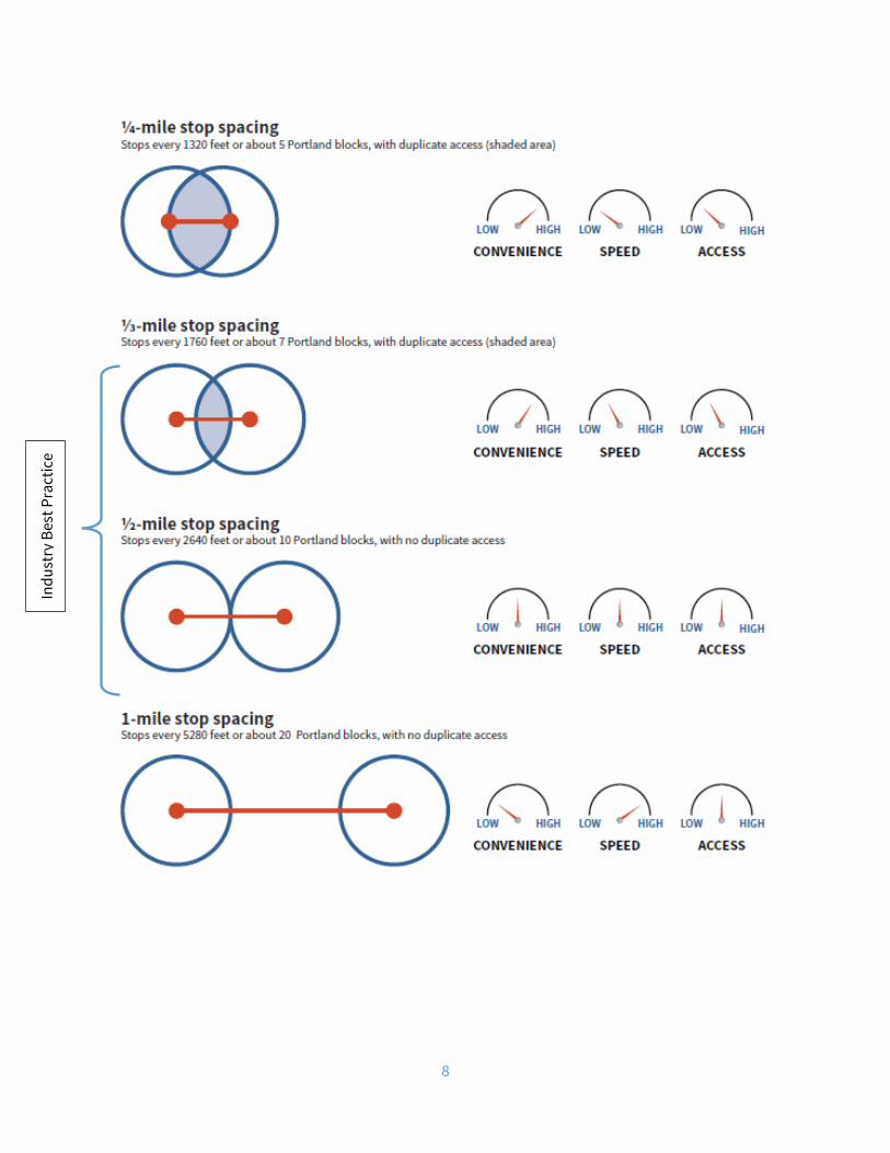
Best Practices: Stop Spacing for Travel Time and Convenience In designing the optimal transit system, transit planners are faced with a balancing act. Customers demand both speed and convenience, which is often determined by the proximity of the nearest station. If stations are spaced too far apart, significant numbers of customers may find it too inconvenient to walk to the station. While speeds are high, ridership suffers due to limited access to stations. On the other hand, if stations are too close together, access is convenient, but speeds are sacrificed as trains slow down approaching stations, stop to load and unload passengers and gradually accelerate out of the station area. In this case, ridership is also lost as those traveling through the area become frustrated with the slow travel times and seek faster alternatives.
The challenge for transit planners is finding the optimal balance of these two characteristics of convenience and speed to serve the greatest number of users. While there are no hard and fast rules regarding station spacing, industry best practices have evolved over the years to guide planners in balancing speed and stop spacing to achieve optimal outcomes.
The Transit Capacity and Quality of Service Manual published in cooperation with the Federal Transit Administration (FTA) and the Transportation Research Board (TRB) states it is reasonable to expect riders to travel up to ¼ mile to reach a stop or station for bus and light-rail. From this, one can determine reasonable distances to place stops. Under these guidelines, stations are spaced no closer than ¼ mile (1,320 ft.) and more typically are spaced at ½ mile (2,640 ft.) More recent TriMet lines such as the MAX Green, Orange, and Yellow lines, and the vast majority of light rail stations on systems across the country all have station spacing using these guidelines.
The following graphic illustrates the tradeoffs that must be considered with different stop spacing distances. The red dots indicate stations with a line for the space between stations. The blue circles are the access or coverage area within ¼ mile of the respective station.
10 https://www.portlandoregon.gov/transportation/73684 11 https://trimet.org/redlineimprovements/
8
Indu
stry
Bes
t Pra
ctic
e
9
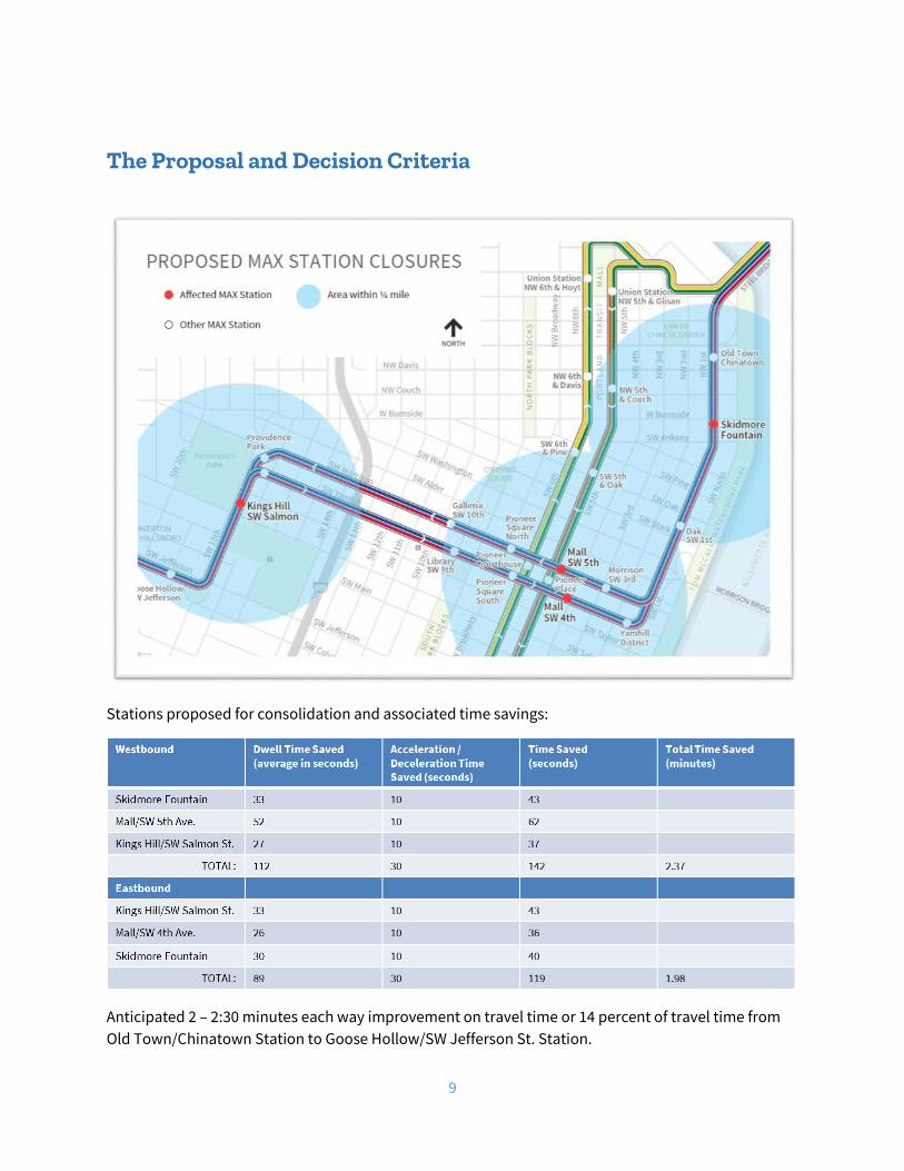
The Proposal and Decision Criteria
Stations proposed for consolidation and associated time savings:
Anticipated 2 – 2:30 minutes each way improvement on travel time or 14 percent of travel time from Old Town/Chinatown Station to Goose Hollow/SW Jefferson St. Station.
10
For the roughly 10,000 typical daily commuters taking a round trip through these stations, about 5 minutes will be saved; which, over the course of a year, adds up to one full day freed up to be spend with family, at work, or having fun.
The 2 – 2:30 minutes of 356 one-way train trips means between 12 and 15 operational hours to reinvest in service reliability.
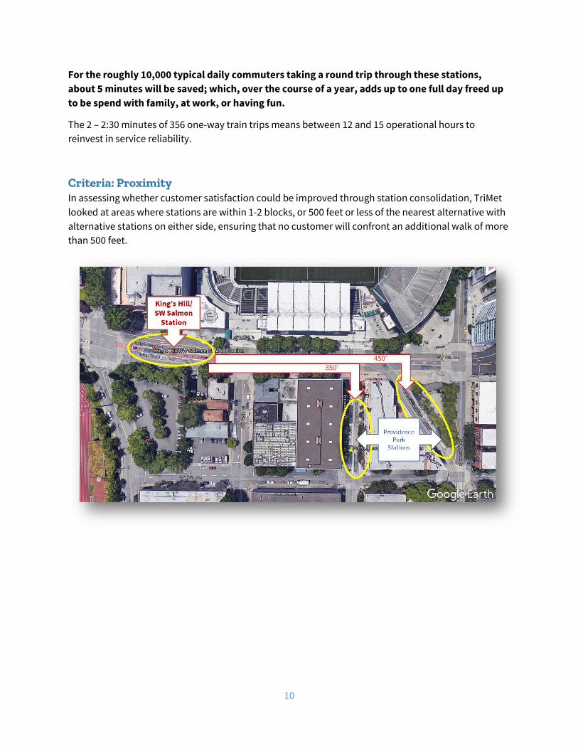
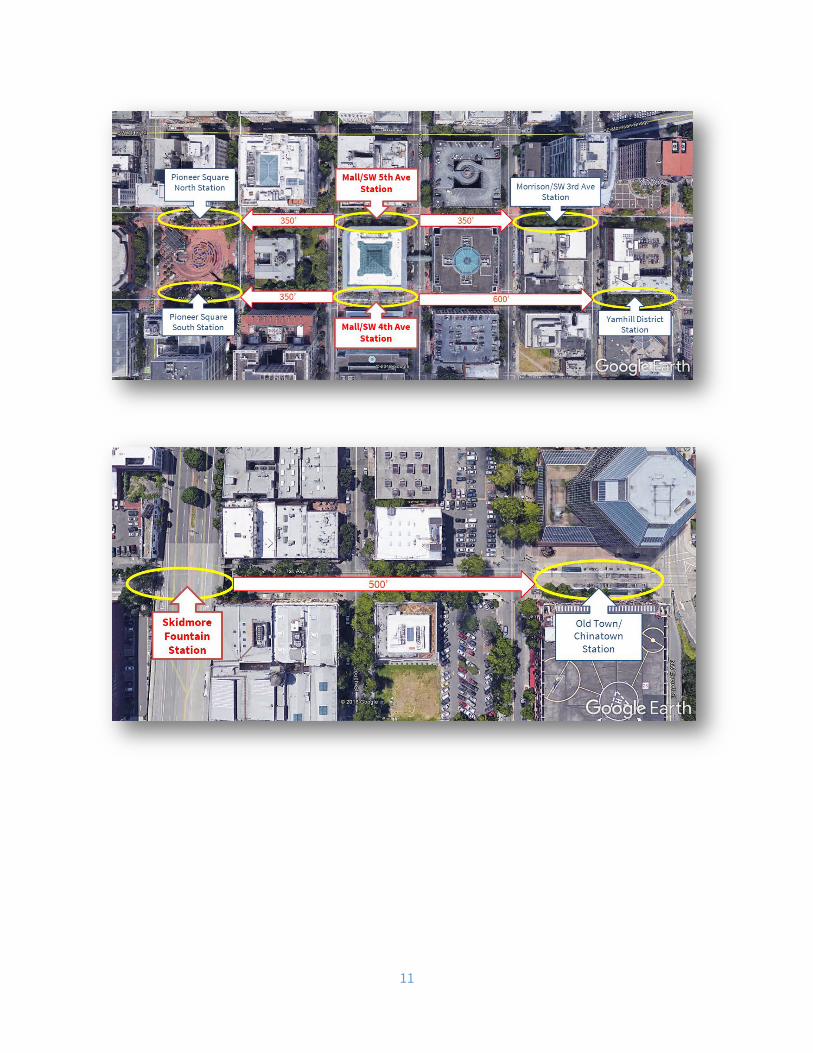
Criteria: Proximity In assessing whether customer satisfaction could be improved through station consolidation, TriMet looked at areas where stations are within 1-2 blocks, or 500 feet or less of the nearest alternative with alternative stations on either side, ensuring that no customer will confront an additional walk of more than 500 feet.
11
12
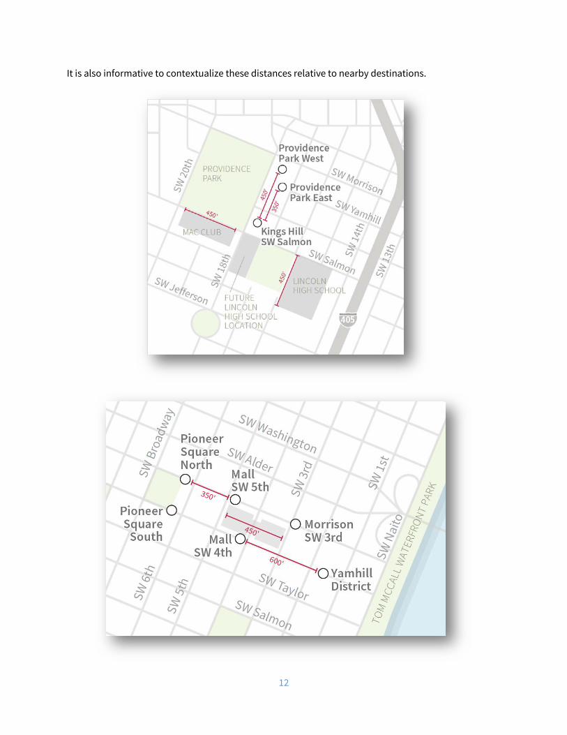
It is also informative to contextualize these distances relative to nearby destinations.
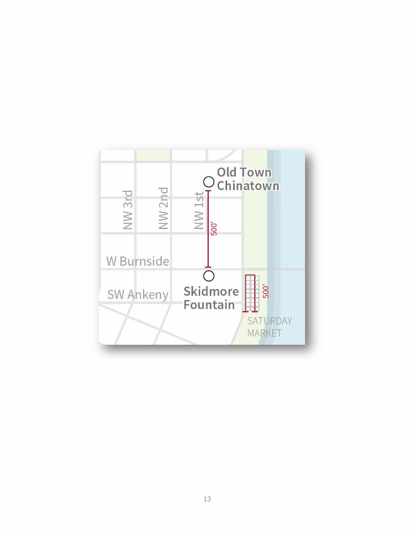
13

14
To convey proximity another way, the following visual compares the length of our trains and platforms to the distances between the stations.

15
Criteria: Access & Coverage The Transit Capacity and Quality of Service Manual states riders can be expected to travel up to ¼ mile to a station. Following that framework, we used GIS to specifically pinpoint the areas affected by the proposal using the walkable pathways versus a simple “as the crow flies” approach. The following graphics visualize the results. Notably many of the areas affected have alternate transit service.

16

17
Cumulative analysis of affectations assuming consolidation of all stations proposed:
Original sidewalk length
Affected sidewalk length
New sidewalk length
Percent Change
Current # of Buildings (sidewalk network)
# of Buildings affected (sidewalk network)
% of Buildings affected (sidewalk network)
611,075 14,073 597,002 -2.303% 739 42 5.68%
18
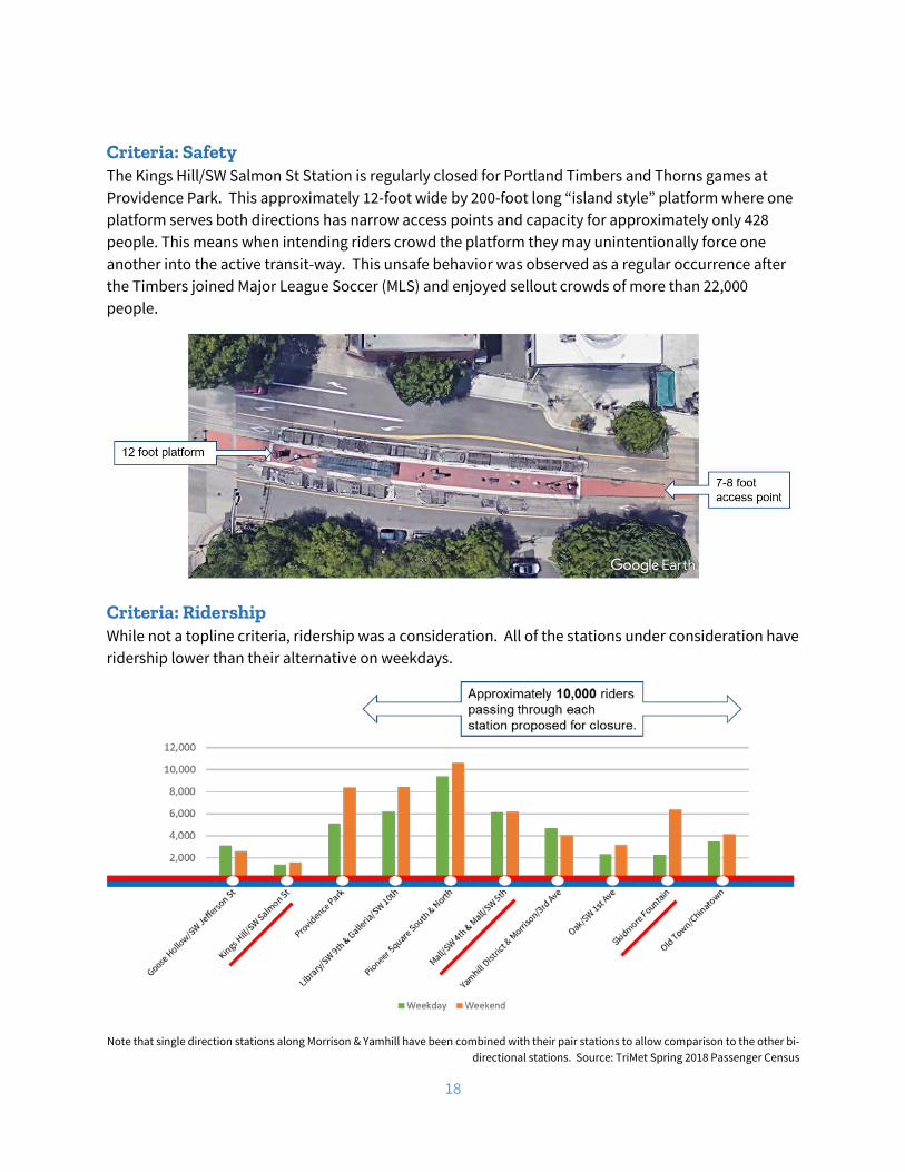
Criteria: Safety The Kings Hill/SW Salmon St Station is regularly closed for Portland Timbers and Thorns games at Providence Park. This approximately 12-foot wide by 200-foot long “island style” platform where one platform serves both directions has narrow access points and capacity for approximately only 428 people. This means when intending riders crowd the platform they may unintentionally force one another into the active transit-way. This unsafe behavior was observed as a regular occurrence after the Timbers joined Major League Soccer (MLS) and enjoyed sellout crowds of more than 22,000 people.
Criteria: Ridership While not a topline criteria, ridership was a consideration. All of the stations under consideration have ridership lower than their alternative on weekdays.
Note that single direction stations along Morrison & Yamhill have been combined with their pair stations to allow comparison to the other bi-
directional stations. Source: TriMet Spring 2018 Passenger Census

19
Impact to Remaining Stations
Dwell Times As riders will shift from using one station to another after consolidation, it is important to consider the dwell times at the alternate station. However, MAX stations have little variation in dwell times thanks to all-door boarding and off-board fare payment.
A logit model was built using average dwell times and ridership at MAX stations across the region to predict the impact of additional ridership. Stations with longer dwell times due to operational factors (such as operator breaks at the end of the line) were discarded. In practicality, riders have alternate stations in both directions. However, for these purposes, we took a worst-case scenario of all riders shifting exclusively to one alternate station.
Providence Park On weekdays, Providence Park platforms see a combined daily ridership of 5,074. If Providence Park were to gain all 1,357 weekday riders from Kings Hill/SW Salmon St., the model predicts only a 3 second increase in dwell times.
20
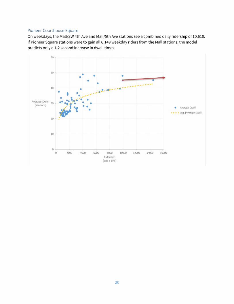
Pioneer Courthouse Square On weekdays, the Mall/SW 4th Ave and Mall/5th Ave stations see a combined daily ridership of 10,610. If Pioneer Square stations were to gain all 6,149 weekday riders from the Mall stations, the model predicts only a 1-2 second increase in dwell times.

21
Old Town/Chinatown On weekdays, the Old Town/Chinatown Station sees a combined daily ridership of 3,462. If Old Town/Chinatown were to gain all 2,245 weekday riders from Skidmore Fountain, the model predicts only a 3 second increase in dwell times.
These are worst case scenarios that assume all travelers from a closed station relocate to a single alternative station. This would not happen in reality as some passengers will have a shorter trip to a different alternative station. Given the very small impact from a worst-case analysis, TriMet anticipates no change in current dwell times at nearby stations due to consolidation.
Platform Capacity As riders shift from using one station to another it is also important to consider whether the alternate station has waiting capacity for intending riders. The consolidated ridership at Providence Park and Old Town/Chinatown stations is well within the range of ridership experienced at other stations and presents no capacity issues. However, should all riders from the Mall stations shift exclusively to using Pioneer Square stations, the resulting ridership would be the highest on the system for a single station or station pair. While this scenario is unlikely, as many riders will find the Yamhill District and Mall/SW 3rd Ave. stations closer alternatives, it is still worth exploring as a possible outcome.
22
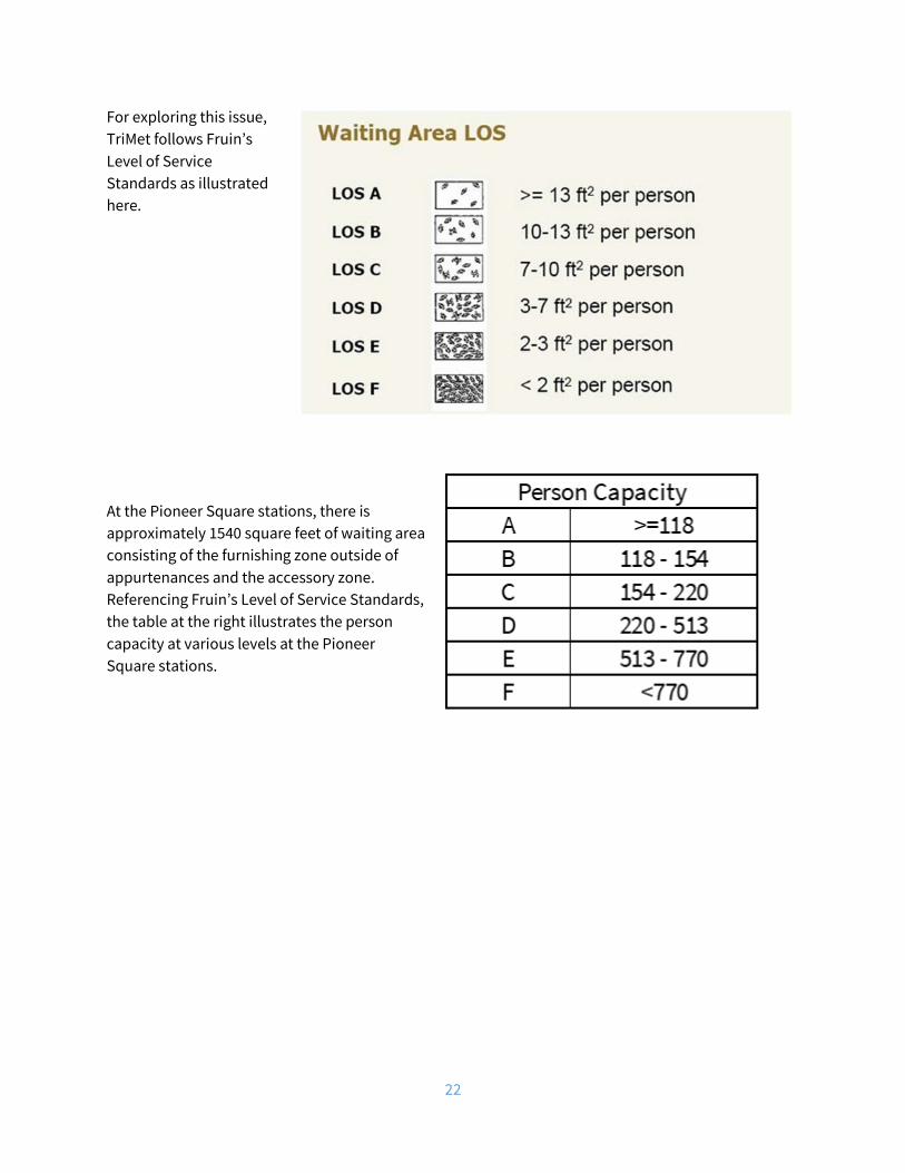
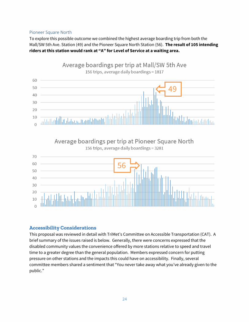
For exploring this issue, TriMet follows Fruin’s Level of Service Standards as illustrated here.
At the Pioneer Square stations, there is approximately 1540 square feet of waiting area consisting of the furnishing zone outside of appurtenances and the accessory zone. Referencing Fruin’s Level of Service Standards, the table at the right illustrates the person capacity at various levels at the Pioneer Square stations.
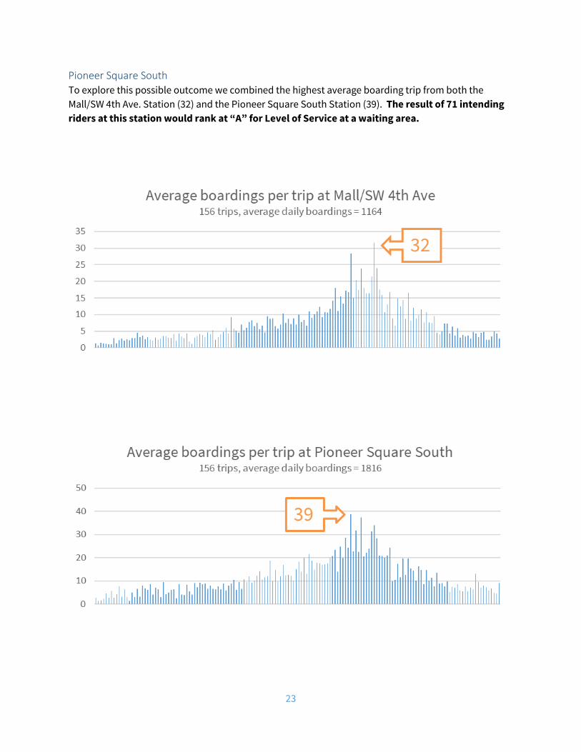
23
Pioneer Square South To explore this possible outcome we combined the highest average boarding trip from both the Mall/SW 4th Ave. Station (32) and the Pioneer Square South Station (39). The result of 71 intending riders at this station would rank at “A” for Level of Service at a waiting area.
24
Pioneer Square North To explore this possible outcome we combined the highest average boarding trip from both the Mall/SW 5th Ave. Station (49) and the Pioneer Square North Station (56). The result of 105 intending riders at this station would rank at “A” for Level of Service at a waiting area.
Accessibility Considerations This proposal was reviewed in detail with TriMet’s Committee on Accessible Transportation (CAT). A brief summary of the issues raised is below. Generally, there were concerns expressed that the disabled community values the convenience offered by more stations relative to speed and travel time to a greater degree than the general population. Members expressed concern for putting pressure on other stations and the impacts this could have on accessibility. Finally, several committee members shared a sentiment that “You never take away what you’ve already given to the public.”
25
Kings Hill/SW Salmon St. Committee members noted that the route to the Providence Park stations is flat. Some also noted that ridership is low and that the station is regularly closed during stadium events. The sporadic nature of these closures creates issues for persons with vision impairments. However, some noted occasional undesirable activity at Providence Park stations makes Kings Hill a more pleasant place to wait. Committee members were more open to closure at this location than the other three.
Mall/SW 5th Ave. & Mall/SW 4th Ave. Committee members expressed concerns regarding uphill nature of the route to the Pioneer Square stations could present challenges to some. This grade was measured as 3.5 percent, which does not exceed ADA Guidelines. Some also shared that these stations offer a shorter distance when making connections to transit service on 5th Avenue. Committee members opposed the closure of these stations.
Skidmore Fountain Committee members expressed concern for rider access to the social services in the area as well as Saturday Market. Additionally, there is a steep section of sidewalk on the east side of 1st Avenue, just north of the station. This grade was measured at 7 percent. This grade, in combination with the fact that the sidewalk is at a different grade than the roadway does not meet ADA Guidelines for a sidewalk. However, it does meet ADA Guidelines for a ramp by being less than 8.33 percent, having level landings at both ends, and not running longer than 30 feet. Still, one committee member noted that her mobility device bottomed out at the top of this ramp. Committee members opposed the closure of this station.
26
Outreach & Engagement: August 2018 through June 2019
Web Page For general public with email to those that signed up for TriMet News
• https://trimet.org/maxdowntown/
Public Notice September 2018 - Mailed to addresses in ¼ mile range around each station proposed for closure.
News Release Sent to all those that subscribe to TriMet News
• http://news.trimet.org/2018/09/trimet-considers-closing-four-low-ridership-closely-spaced-max-stations-to-move-trains-more-efficiently-through-downtown-portland/
Twitter • https://twitter.com/trimet/status/1037520090038587392
Facebook • Main Facebook post on 9/5/2018 pointed to https://trimet.org/maxdowntown/ • Open houses listed under outreach events above had corresponding Facebook events that
were promoted.
Presentations or Conversations August 16, 2018
• City of Portland, Bureau of Transportation, Planning Staff
August 28, 2018
• Portland Saturday Market – Director of Marketing, Reid Decker • Mercy Corp – Director of Facilities, Hugh Donnelly
August 29, 2018
• The Nines Hotel – Convention Services Manager, Lai-Sin Ley
August 30, 2018
• Portland Rescue Mission – Executive Director, Eric Bauer • Pioneer Place – Marketing Manager, Sandra Rollinson • Pioneer Courthouse Square – Building Management, Robert Walch
September 7, 2018
• Apple Store – Management • Niketown - Management
27
September 14, 2018
• Lincoln High School, Principal Peyton Chapman
September 15, 2018
• Multnomah Athletic Club – General Manager, Norman Rich
September 18, 2018
• Goose Hollow Foothills League, Land Use and Transportation Committee
September 24, 2018
• University of Oregon Vice Provost, Jane Gordon
October 18, 2018
• Stadium District Business Association
November 7, 2018
• Old Town/Chinatown Community Association
November 27, 2018
• Lincoln High School (Principal Chapman, Bernie Bottomly, Clay Thompson, Mary Fetsch, two students, and former TriMet General Manager - Tom Walsh)
November 27, 2018
• Portland Business Alliance Transportation Committee
January 8, 2019
• Downtown Public Safety Committee
January 10, 2019
• Go Lloyd Board
February 5, 2019
• NWDA Board
March 8, 2019
• Lan Su Chinese Garden Executive Director, Lisa James
March 15, 2019
• Westside Transportation Alliance
28
May 13, 2019
• Washington County Coordinating Committee
May 14, 2019
• Transportation Equity Advisory Committee
May 30, 2019
• Mercy Corps
Outreach Events MAX Station Optimization was part of the first and second rounds of FY20 outreach, including handouts and online at trimet.org/plan
• September 2018 – seven open houses (one in each Board district) • February 2019 – two open houses (third one in Beaverton cancelled due to weather)
Street Events TriMet information booth at Goose Hollow Days – September 15, 2018
Surveys • February 2019 – Survey sent to those who receive service alerts for MAX Blue and Red Lines. • March 2019 – onboard passenger survey • March 2019 – intercept surveys at Kings Hill/SW Salmon St. Station, and Skidmore Fountain
Station
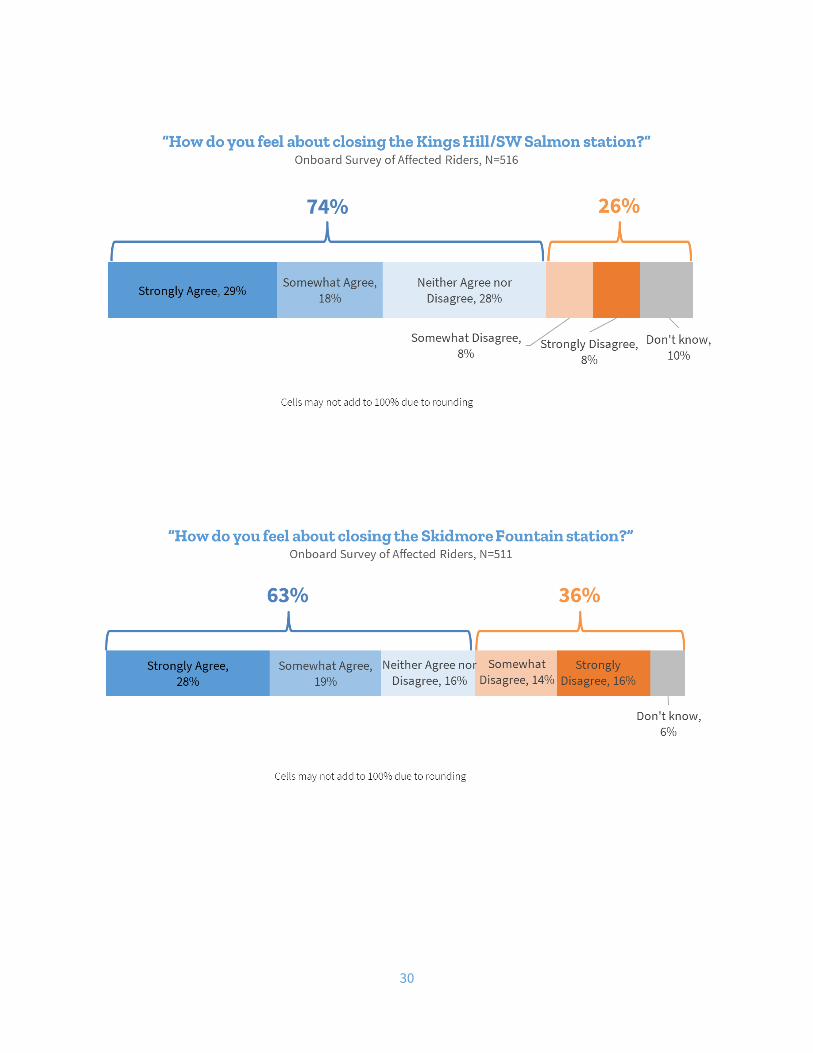
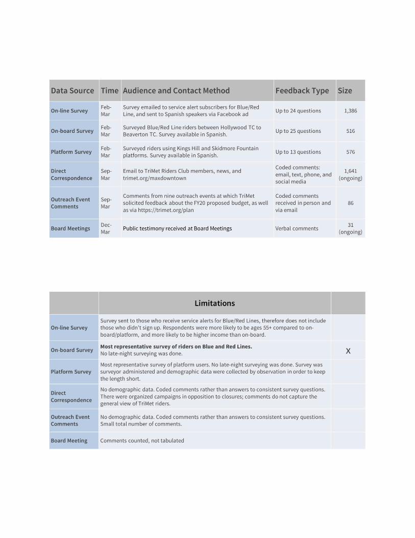
Through these many sources of feedback, it became clear that there was not significant concern with closure of Mall/SW 4th Ave. and Mall/SW 5th Ave. stations. There were, however, organized campaigns in opposition to the closure of Kings Hill/SW Salmon St. and Skidmore Fountain stations. Consequently, it became imperative to consider the limitations of these many sources. The onboard survey, by its methodology, is the most representative of the sentiments of MAX Blue and Red Line riders.
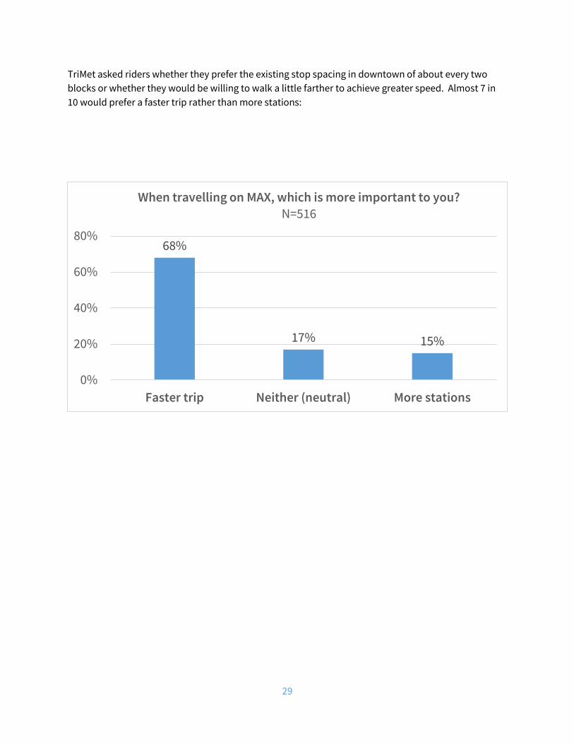
The onboard survey was offered to MAX Blue and Red Line riders between Hollywood Transit Center and Beaverton Transit Center, with a target of those going to or through downtown. Those who had taken the survey before were screened out. The self-administered survey was taken by 516 riders with a 75 percent response rate. The majority, 91 percent, of responses were from the target. The survey was conducted Feb. 19, 2019 to March 14, 2019. The surveys were done in eight 4-hour shifts during the hours of 6:30 a.m. to 6:30 p.m. on weekdays and 10 a.m. and 7 p.m. on weekends. This survey yielded the following key results. Additional results available in Appendix A.
29
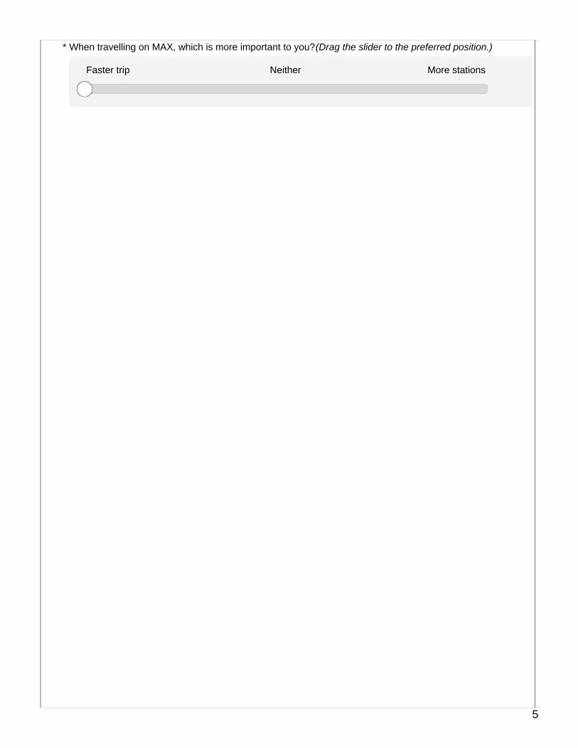
TriMet asked riders whether they prefer the existing stop spacing in downtown of about every two blocks or whether they would be willing to walk a little farther to achieve greater speed. Almost 7 in 10 would prefer a faster trip rather than more stations:
68%
17% 15%
0%
20%
40%
60%
80%
Faster trip Neither (neutral) More stations
When travelling on MAX, which is more important to you?N=516
30
31
Recommendation and Conclusion Since the opening of the Westside Light Rail Project in 1998 customers have used the light rail system both to travel into the central city but also to travel through the central city. With gentrification and the development of new regional employment centers, particularly in Washington County, many of the area’s low income and minority residents are forced to travel longer distances to access employment, including making trips from east Portland to Washington County. Low income and minority residents are the most vulnerable to the consequences of long commutes and unpredictable schedules. Improving travel speeds in the central city, without unduly impacting convenience, is an important step TriMet can take to support these communities and promote regional equity. Over the past two plus years, TriMet has undertaken a comprehensive program of improvements aimed at increasing the speed and reliability of the light rail system. On-time performance has increased from the mid-70 percent range to 92 percent. The agency has also made changes in the Steel Bridge, emergency response procedures, and law enforcement and hot weather operations that have improved both speed and reliability. As part of this comprehensive program, TriMet conducted an examination of the number of stations in the downtown, where station spacing is closer than industry best practices and where there is considerable overlap in the convenient walkshed of stations. The goal of this examination was to determine if overlapping stations could be consolidated with other nearby stations to improve travel times without unduly affecting the convenience of customers wishing to access destinations in downtown. TriMet’s analysis concludes that four stations in downtown could be consolidated with nearby alternative stations due to their extremely close proximity. However, the analysis also finds that each station presents a unique set of challenges and considerations and therefore no single approach is appropriate. With that in mind, this report makes the following recommendations: Skidmore Fountain Station: TriMet recommends that closure of the Skidmore Fountain Station be deferred for three years. During the three-year period, TriMet will further review and evaluate the potential closure of the station based on developments in and around the station, including investments by area firms and organizations directed at increasing weekday use of the station, including expanded adoption of universal pass programs, improvements in safety, cleaning and security and fulfillment of plans for additional development in the vicinity. If these changes are not forthcoming in the three years after the adoption of this resolution, TriMet will recommend station consolidation. Kings Hill/SW Salmon St. Station: TriMet recommends that Kings Hill/SW Salmon St. be closed for a one-year trial period. During the one-year period in which the station is closed TriMet will review and evaluate the result of the closure, including any effects on transit system speed, on-time performance, MAX ridership, use of alternative stations, crime and neighborhood issues, and present a report of its findings to the Board within the period of the station’s closure.
32
Mall/SW 4th Ave. and Mall/SW 5th Ave. Stations: TriMet recommends that both Mall stations be closed permanently. The effective date of all changes would be March 2, 2020, to coincide with TriMet’s twice yearly schedule changes and to allow time for improvements to the light rail signal and train control systems.
33
Appendices
34
Appendix A – Outreach & Engagement Data
(see subsequent pages)

Surveyor use only
MAX - Proposed Station Closures DowntownOn-Board Survey
MAX *
Blue Line Red Line
Direction*
Westbound Eastbound
English or Spanish*
English
Spanish (Enter this, and then exit the English survey. Open the Spanish survey link and hand tablet to passenger.)
1
We're surveying riders about closing 4 MAX stations downtown to speed up travel time. Will youplease take our survey?
Surveyor use only
MAX - Proposed Station Closures DowntownOn-Board Survey
Willing to take survey?*
Yes
No (Enter this, and survey will start over.)
2
Surveyor use only
MAX - Proposed Station Closures DowntownOn-Board Survey
At what station did you get on this train? If needed, see stations on this map: https://trimet.org/maps/img/railsystem.png
West of Kings Hill station
Kings Hill station to Skidmore Fountain station
East of Skidmore Fountain station
Don't know
Other (please specify)
At what station will you get off the train? If needed, see stations on this map: https://trimet.org/maps/img/railsystem.png
West of Kings Hill station
Kings Hill station to Skidmore Fountain station
East of Skidmore Fountain station
Don't know
Other (please specify)
Now hand tablet to passenger.
3
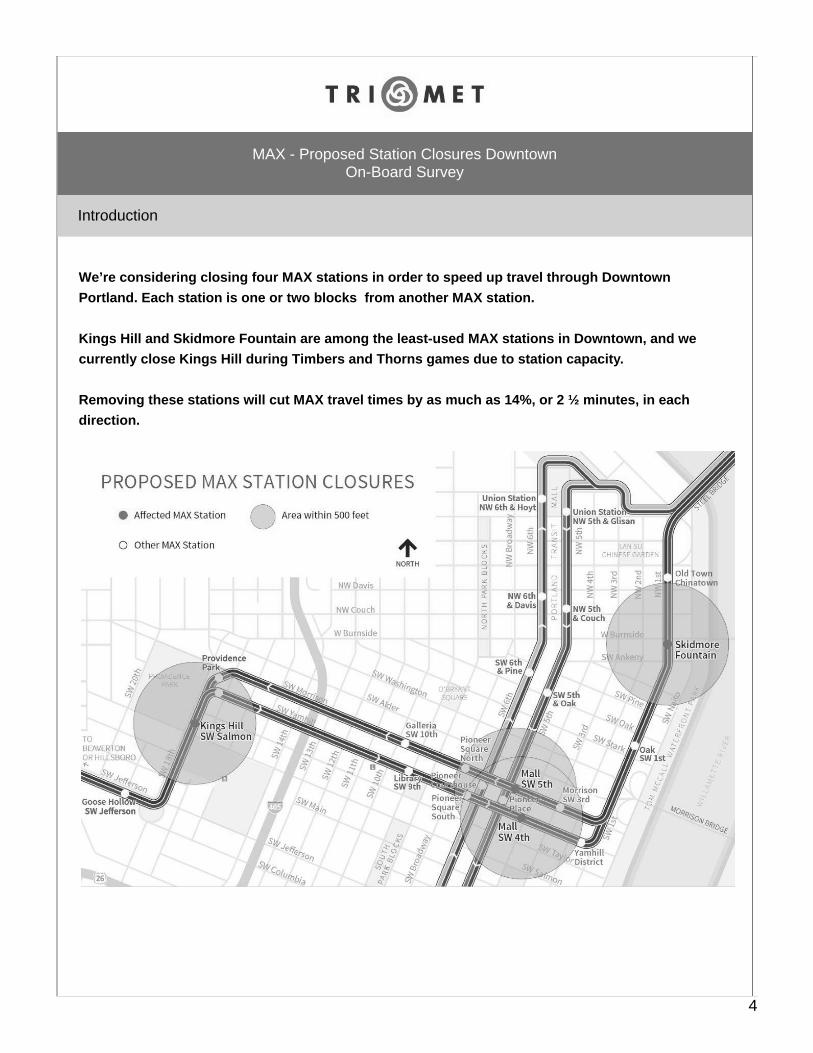
We’re considering closing four MAX stations in order to speed up travel through DowntownPortland. Each station is one or two blocks from another MAX station.
Kings Hill and Skidmore Fountain are among the least-used MAX stations in Downtown, and wecurrently close Kings Hill during Timbers and Thorns games due to station capacity.
Removing these stations will cut MAX travel times by as much as 14%, or 2 ½ minutes, in eachdirection.
Introduction
MAX - Proposed Station Closures DowntownOn-Board Survey
4
When travelling on MAX, which is more important to you? (Drag the slider to the preferred position.)*
Faster trip Neither More stations
5

Kings Hill/SW Salmon
MAX - Proposed Station Closures DowntownOn-Board Survey
Strongly agree withclosure
Somewhat agreewith closure
Neither agree nordisagree
Somewhat disagreewith closure
Strongly disagreewith closure Don't know
How do you feel about closing the Kings Hill/SW Salmon station?*
6
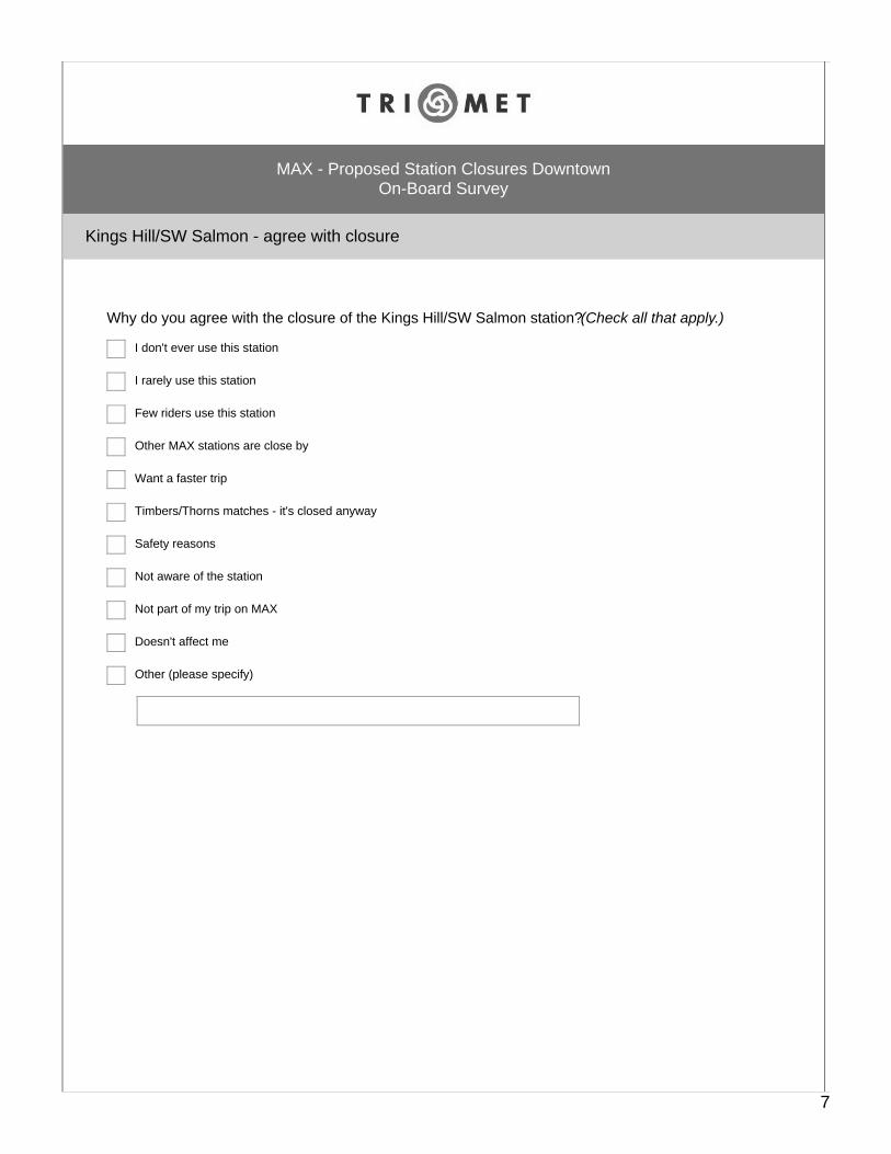
Kings Hill/SW Salmon - agree with closure
MAX - Proposed Station Closures DowntownOn-Board Survey
Why do you agree with the closure of the Kings Hill/SW Salmon station? (Check all that apply.)
I don't ever use this station
I rarely use this station
Few riders use this station
Other MAX stations are close by
Want a faster trip
Timbers/Thorns matches - it's closed anyway
Safety reasons
Not aware of the station
Not part of my trip on MAX
Doesn't affect me
Other (please specify)
7
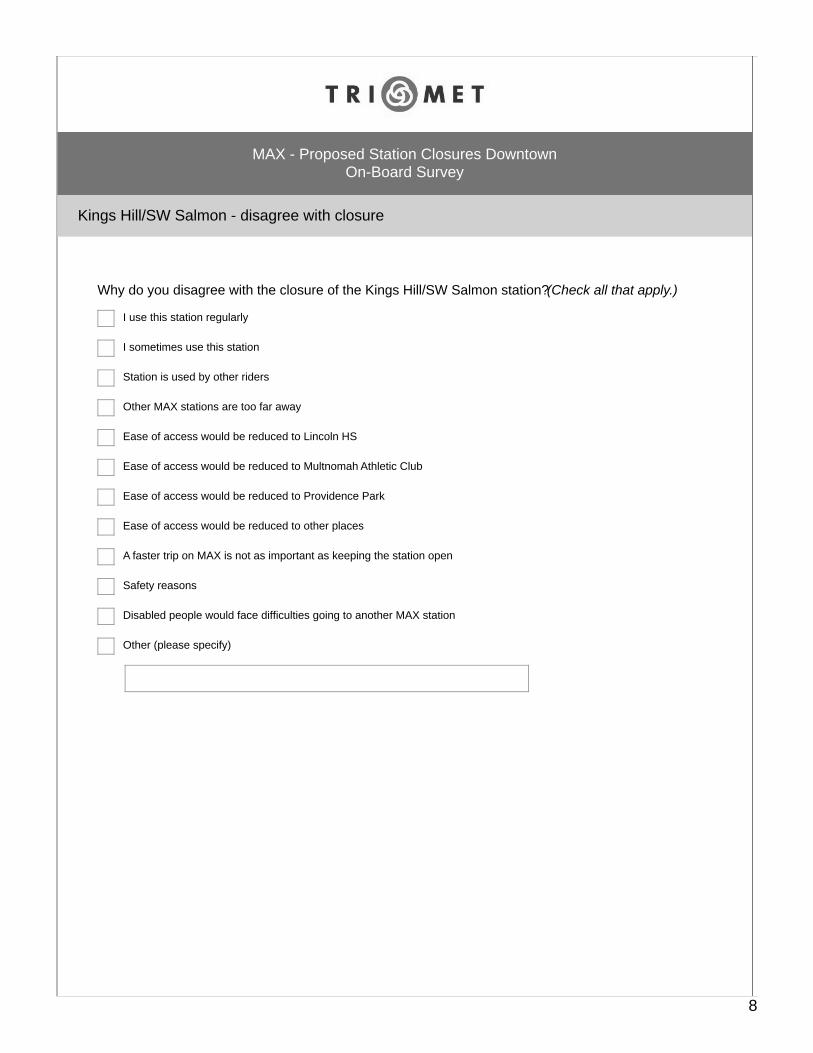
Kings Hill/SW Salmon - disagree with closure
MAX - Proposed Station Closures DowntownOn-Board Survey
Why do you disagree with the closure of the Kings Hill/SW Salmon station? (Check all that apply.)
I use this station regularly
I sometimes use this station
Station is used by other riders
Other MAX stations are too far away
Ease of access would be reduced to Lincoln HS
Ease of access would be reduced to Multnomah Athletic Club
Ease of access would be reduced to Providence Park
Ease of access would be reduced to other places
A faster trip on MAX is not as important as keeping the station open
Safety reasons
Disabled people would face difficulties going to another MAX station
Other (please specify)
8
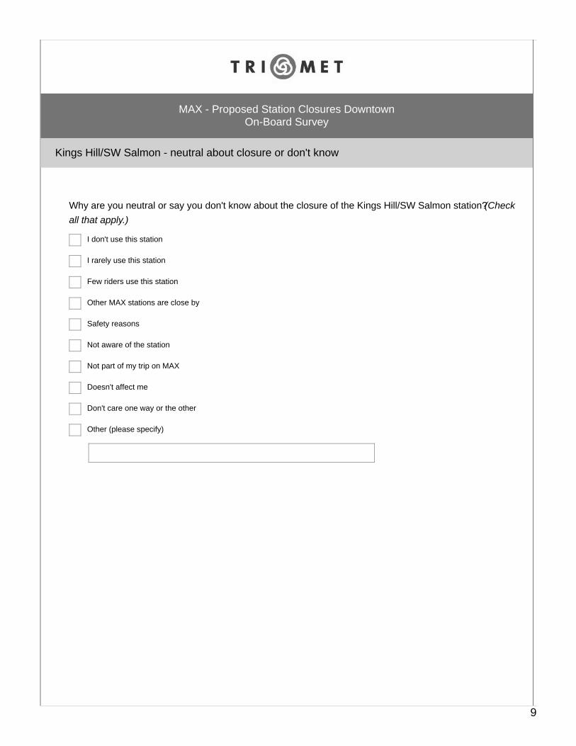
Kings Hill/SW Salmon - neutral about closure or don't know
MAX - Proposed Station Closures DowntownOn-Board Survey
Why are you neutral or say you don't know about the closure of the Kings Hill/SW Salmon station? (Checkall that apply.)
I don't use this station
I rarely use this station
Few riders use this station
Other MAX stations are close by
Safety reasons
Not aware of the station
Not part of my trip on MAX
Doesn't affect me
Don't care one way or the other
Other (please specify)
9

Kings Hill/SW Salmon station - usage
MAX - Proposed Station Closures DowntownOn-Board Survey
Do you ever use the Kings Hill/SW Salmon station?*
Yes
No
Don't know
10
Kings Hill/SW Salmon station - usage
MAX - Proposed Station Closures DowntownOn-Board Survey
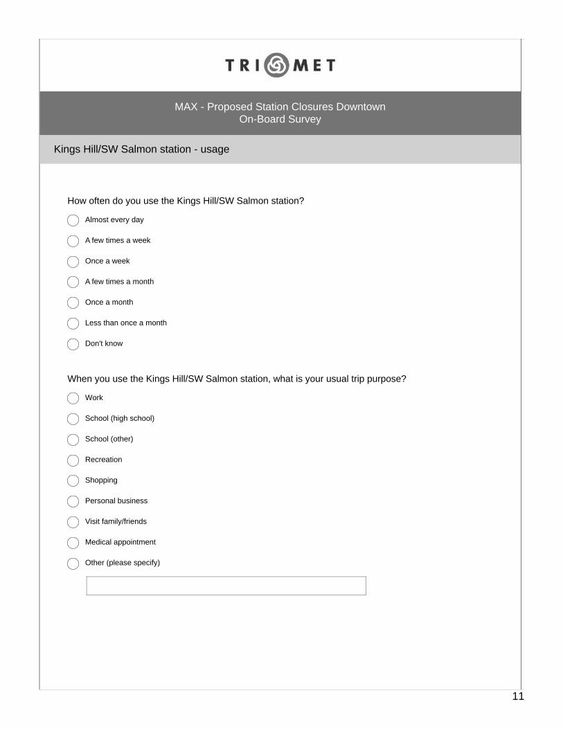
How often do you use the Kings Hill/SW Salmon station?
Almost every day
A few times a week
Once a week
A few times a month
Once a month
Less than once a month
Don't know
When you use the Kings Hill/SW Salmon station, what is your usual trip purpose?
Work
School (high school)
School (other)
Recreation
Shopping
Personal business
Visit family/friends
Medical appointment
Other (please specify)
11
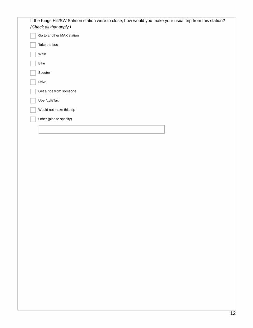
If the Kings Hill/SW Salmon station were to close, how would you make your usual trip from this station? (Check all that apply.)
Go to another MAX station
Take the bus
Walk
Bike
Scooter
Drive
Get a ride from someone
Uber/Lyft/Taxi
Would not make this trip
Other (please specify)
12
Skidmore Fountain
MAX - Proposed Station Closures DowntownOn-Board Survey
Strongly agree withclosure
Somewhat agreewith closure
Neither agree nordisagree
Somewhat disagreewith closure
Strongly disagreewith closure Don't know
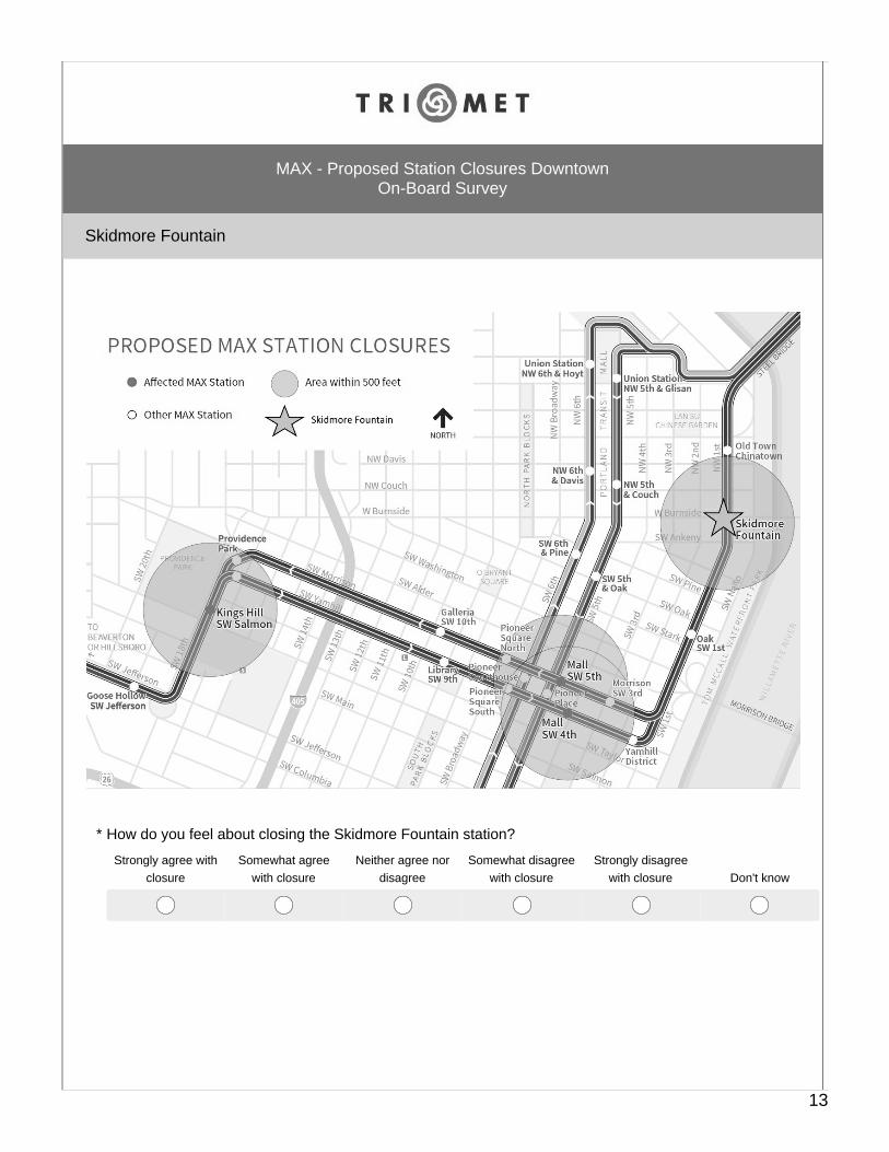
How do you feel about closing the Skidmore Fountain station?*
13
Skidmore Fountain - agree with closure
MAX - Proposed Station Closures DowntownOn-Board Survey
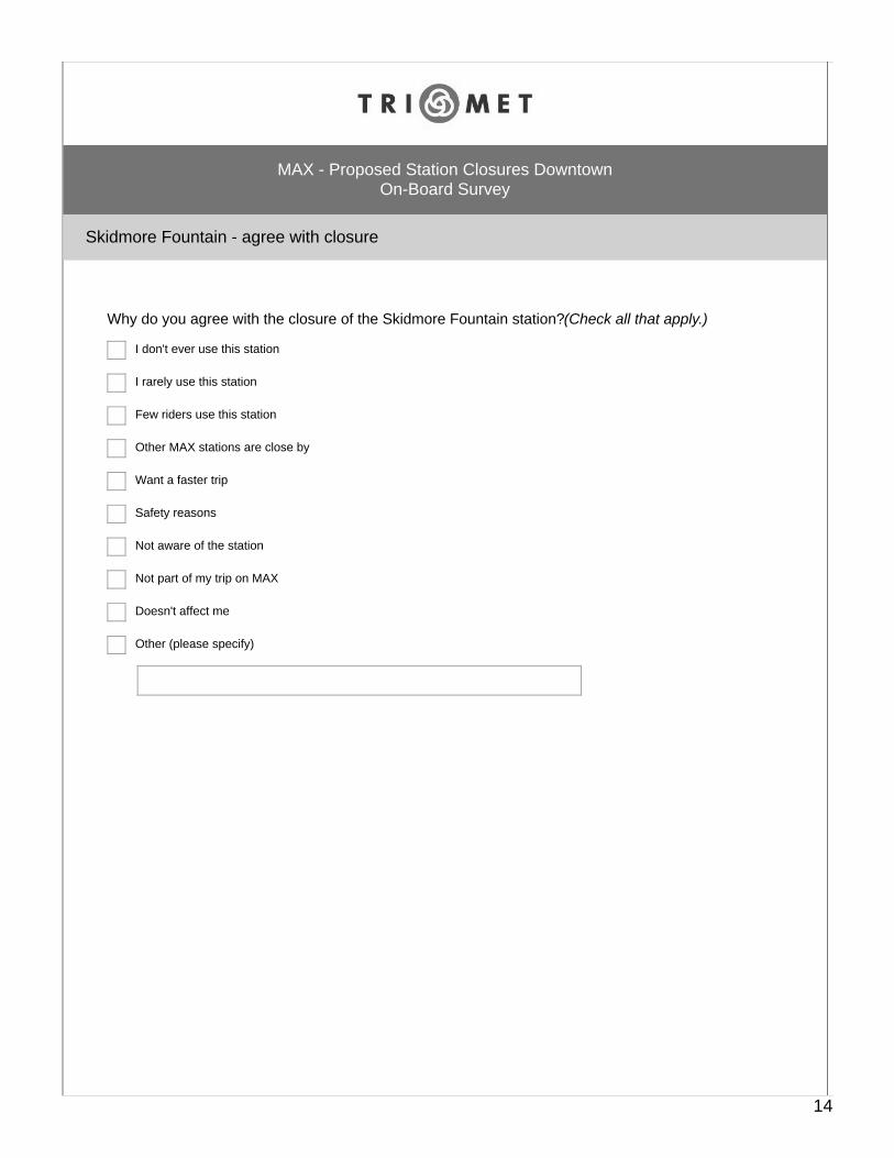
Why do you agree with the closure of the Skidmore Fountain station? (Check all that apply.)
I don't ever use this station
I rarely use this station
Few riders use this station
Other MAX stations are close by
Want a faster trip
Safety reasons
Not aware of the station
Not part of my trip on MAX
Doesn't affect me
Other (please specify)
14
Skidmore Fountain - disagree with closure
MAX - Proposed Station Closures DowntownOn-Board Survey
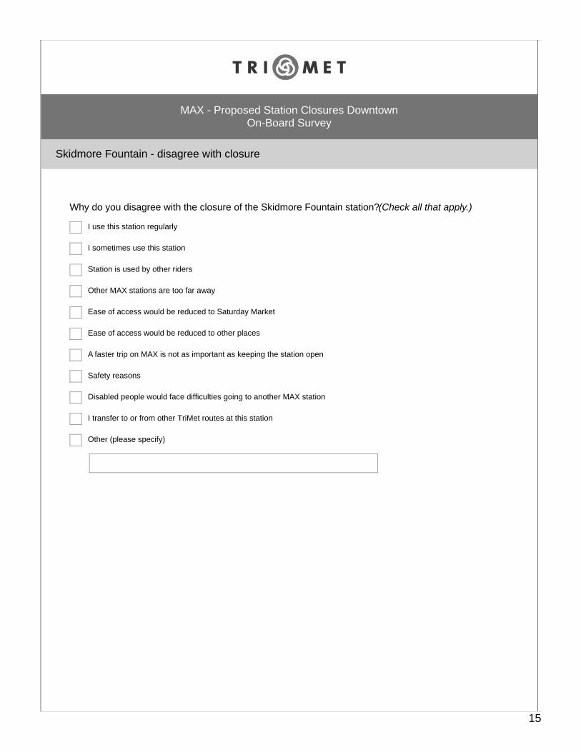
Why do you disagree with the closure of the Skidmore Fountain station? (Check all that apply.)
I use this station regularly
I sometimes use this station
Station is used by other riders
Other MAX stations are too far away
Ease of access would be reduced to Saturday Market
Ease of access would be reduced to other places
A faster trip on MAX is not as important as keeping the station open
Safety reasons
Disabled people would face difficulties going to another MAX station
I transfer to or from other TriMet routes at this station
Other (please specify)
15
Skidmore Fountain - neutral about closure or don't know
MAX - Proposed Station Closures DowntownOn-Board Survey
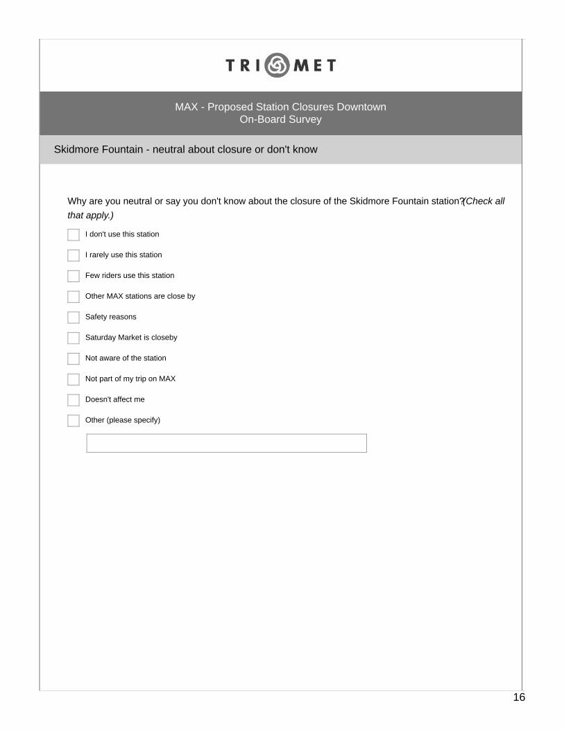
Why are you neutral or say you don't know about the closure of the Skidmore Fountain station? (Check allthat apply.)
I don't use this station
I rarely use this station
Few riders use this station
Other MAX stations are close by
Safety reasons
Saturday Market is closeby
Not aware of the station
Not part of my trip on MAX
Doesn't affect me
Other (please specify)
16
Skidmore Fountain station - usage
MAX - Proposed Station Closures DowntownOn-Board Survey
Do you ever use the Skidmore Fountain station?*
Yes
No
Don't know
17
Skidmore Fountain station - usage
MAX - Proposed Station Closures DowntownOn-Board Survey
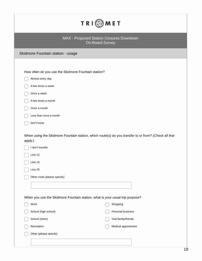
How often do you use the Skidmore Fountain station?
Almost every day
A few times a week
Once a week
A few times a month
Once a month
Less than once a month
Don't know
When using the Skidmore Fountain station, which route(s) do you transfer to or from? (Check all thatapply.)
I don't transfer
Line 12
Line 19
Line 20
Other route (please specify)
When you use the Skidmore Fountain station, what is your usual trip purpose?
Work
School (high school)
School (other)
Recreation
Shopping
Personal business
Visit family/friends
Medical appointment
Other (please specify)
18
If the Skidmore Fountain station were to close, how would you make your usual trip from this station?(Check all that apply.)
Go to another MAX station
Take the bus
Walk
Bike
Scooter
Drive
Get a ride from someone
Uber/Lyft/Taxi
Would not make this trip
Other (please specify)
19
Ridership
MAX - Proposed Station Closures DowntownOn-Board Survey
About how often do you ride TriMet?
Almost every day
Several times a week
Once a week
Several times a month
Once a month
Less than once a month
Don't know
Would you ride TriMet more, the same or less if these downtown MAX stations were to close?
More
The same
Less
Don't know
20
About you
MAX - Proposed Station Closures DowntownOn-Board Survey
What is your home zip code?
Do you have a disability which makes it difficult to walk a few blocks?
Yes
No
Don't know
What is your age?
Under 18
18-24
25-34
35-44
45-54
55-64
65+
What is your gender or gender identity?
Male
Female
Transgender
Other (please specify)
21
What is your race or ethnicity? (Check all that apply.)
African American or Black
American Indian or Alaska Native
Asian or Asian American
Caucasian or White
Hispanic or Latino
Middle Eastern or North African
Native Hawaiian or other Pacific Islander
Bi-racial or multi-racial
Other (please specify)
Including yourself, how many people live in your household?
What was your total annual household income before taxes in 2018?
Under $20,000
$20,000 - $29,999
$30,000 - $39,999
$40,000 - $49,999
$50,000 - $59,999
$60,000 - $69,999
$70,000 - $79,999
$80,000 - $89,999
$90,000 - $99,999
$100,000 or more
Don't know
22
Please hand the tablet back to the surveyor.
Thank you, your opinion counts.
MAX - Proposed Station Closures DowntownOn-Board Survey
23
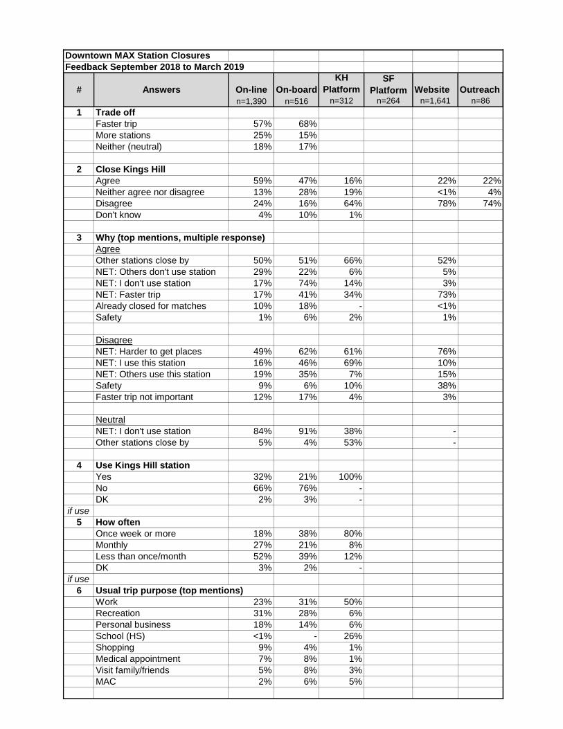
Downtown MAX Station Closures
Feedback September 2018 to March 2019
On-line On-board
KH
Platform
SF
Platform Website Outreach
n=1,390 n=516 n=312 n=264 n=1,641 n=861 Trade off
Faster trip 57% 68%More stations 25% 15%Neither (neutral) 18% 17%
2 Close Kings Hill
Agree 59% 47% 16% 22% 22%Neither agree nor disagree 13% 28% 19% <1% 4%Disagree 24% 16% 64% 78% 74%Don't know 4% 10% 1%
3 Why (top mentions, multiple response)
AgreeOther stations close by 50% 51% 66% 52%NET: Others don't use station 29% 22% 6% 5%NET: I don't use station 17% 74% 14% 3%NET: Faster trip 17% 41% 34% 73%Already closed for matches 10% 18% - <1%Safety 1% 6% 2% 1%
DisagreeNET: Harder to get places 49% 62% 61% 76%NET: I use this station 16% 46% 69% 10%NET: Others use this station 19% 35% 7% 15%Safety 9% 6% 10% 38%Faster trip not important 12% 17% 4% 3%
NeutralNET: I don't use station 84% 91% 38% -Other stations close by 5% 4% 53% -
4 Use Kings Hill station
Yes 32% 21% 100%No 66% 76% -DK 2% 3% -
if use
5 How often
Once week or more 18% 38% 80%Monthly 27% 21% 8%Less than once/month 52% 39% 12%DK 3% 2% -
if use
6 Usual trip purpose (top mentions)
Work 23% 31% 50%Recreation 31% 28% 6%Personal business 18% 14% 6%School (HS) <1% - 26%Shopping 9% 4% 1%Medical appointment 7% 8% 1%Visit family/friends 5% 8% 3%MAC 2% 6% 5%
# Answers

Downtown MAX Station Closures
Feedback September 2018 to March 2019
On-line On-board
KH
Platform
SF
Platform Website Outreach
n=1,390 n=516 n=312 n=264 n=1,641 n=86# Answers
if use
7 If closed, do instead (top mentions, multiple response)
NET: Another station/walk 76% 85% 91%Go to another MAX station 64% 74% 87%Walk 25% 27% 7%
NET: Drive 15% 10% 7%Take the bus 8% 7% 6%Wouldn't make trip 12% 4% 1%Bike 2% 4% <1%
8 Close Skidmore Fountain
Agree 50% 47% 18% 48% 15%Neither agree nor disagree 12% 16% 19% - 1%Disagree 36% 31% 63% 53% 84%Don't know 2% 6% -
9 Why (top mentions, multiple response)
AgreeSafety 50% 45% 38% 6%Other stations close by 27% 39% 52% 33%NET: I don't use station 11% 64% 8% 2%NET: Faster trip 14% 38% 21% 75%Others don't use station 14% 17% 2% 10%
DisagreeNET: Harder to get places 71% 59% 71% 70%NET: I use this station 16% 59% 46% 14%NET: Others use this station 14% 31% 17% 6%Safety 11% 6% 9% 11%Faster trip not important 4% 15% 8% 18%Transfer at this station 4% 4% - 3%
NeutralNET: I don't use station 60% 84% 51% -Saturday Market close by 22% 8% 20% -Safety 17% 5% 16% -Other stations close by 8% 6% 33% -
10 Use Skidmore Fountain
Yes 51% 47% 100%No 47% 51% -DK 2% 2% -
if use
11 How often
Once week or more 14% 24% 47%Monthly 33% 30% 22%Less than once/month 50% 42% 32%DK 3% 4% -
if use
12 Transfer at this station
No 85% 82% 87%Yes 15% 18% 13%
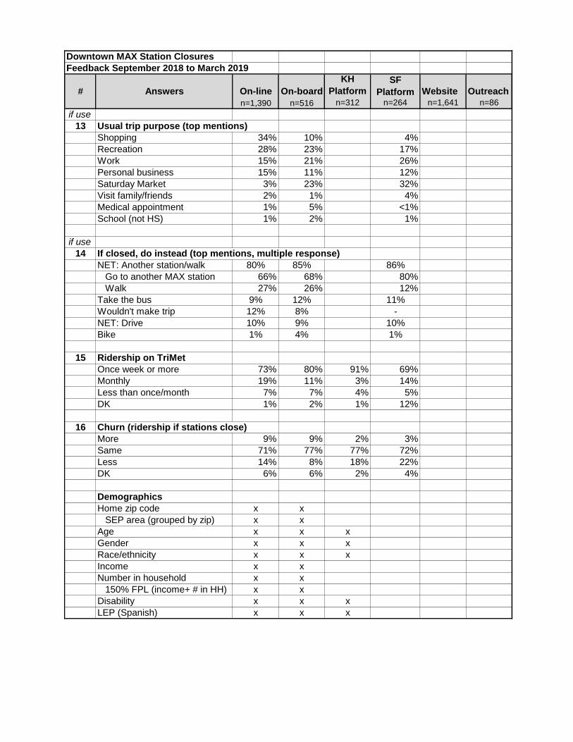
Downtown MAX Station Closures
Feedback September 2018 to March 2019
On-line On-board
KH
Platform
SF
Platform Website Outreach
n=1,390 n=516 n=312 n=264 n=1,641 n=86# Answers
if use
13 Usual trip purpose (top mentions)
Shopping 34% 10% 4%Recreation 28% 23% 17%Work 15% 21% 26%Personal business 15% 11% 12%Saturday Market 3% 23% 32%Visit family/friends 2% 1% 4%Medical appointment 1% 5% <1%School (not HS) 1% 2% 1%
if use
14 If closed, do instead (top mentions, multiple response)
NET: Another station/walk 80% 85% 86%Go to another MAX station 66% 68% 80%Walk 27% 26% 12%
Take the bus 9% 12% 11%Wouldn't make trip 12% 8% -NET: Drive 10% 9% 10%Bike 1% 4% 1%
15 Ridership on TriMet
Once week or more 73% 80% 91% 69%Monthly 19% 11% 3% 14%Less than once/month 7% 7% 4% 5%DK 1% 2% 1% 12%
16 Churn (ridership if stations close)
More 9% 9% 2% 3%Same 71% 77% 77% 72%Less 14% 8% 18% 22%DK 6% 6% 2% 4%
Demographics
Home zip code x xSEP area (grouped by zip) x x
Age x x xGender x x xRace/ethnicity x x xIncome x xNumber in household x x 150% FPL (income+ # in HH) x xDisability x x xLEP (Spanish) x x x
35
Appendix B – Title VI Equity Analysis
(see subsequent pages)

Tri-County Metropolitan Transportation District of Oregon 1800 SW First Avenue, Suite 300, Portland, Oregon 97201 503-238-RIDE TTY 7-1-1 trimet.org
Date: June 20, 2019 To: Distribution From: Carl Green Jr, Title VI & Equity Programs Administrator Subject: MAX Station Optimization Title VI Analysis and Transit Equity Considerations ______ This memo summarizes the analysis to determine whether there are adverse effects on minority and low-income populations regarding the MAX Station Optimization proposal. A literature review on transit equity will be used to present additional factors to be considered when evaluating transportation investments or making changes to a transit system. Title VI System-Wide Service Policies and Standards TriMet has established standards and policies for evaluating the potential impacts of proposed service changes on minority and low income populations as set forward in FTA Circular 4702.1B. These standards and policies assist in guiding the development and delivery of service in support of TriMet’s mission to provide valued transit service that is safe, dependable, and easy to use. They also provide benchmarks to ensure that service design and operations practices do not result in discrimination on the basis of race, color, or national origin. They establish a basis for monitoring and analysis of service delivery, availability, and the distribution of amenities and vehicles to determine whether or not any Disparate Impacts or Disproportionate Burdens are evident. Service Availability Standard In conformance with the Federal Transit Administration regulation, TriMet’s standards for availability of service are that persons residing within one-half mile of rail station and one-quarter mile of a bus stop are considered served by the transit system. Service availability is expressed as number and percentage of District-wide population and is determined by mode; for bus, MAX, and WES respectively. TriMet’s Title VI standard reflects the expectation that minority and low income populations should have proportionally equal access to the transit system as do non-minority and non-low income populations. In other words, for example, if 60% of the non-minority population has access to transit within ½ mile then at least 60% of the minority population should have access to transit within ½ mile. MAX Blue and Red Line – Current and Future State The MAX Blue Line runs 33 miles connecting the Hatfield Government Center in Hillsboro to Cleveland Ave in Gresham. The MAX Red Line runs 20 miles connecting the Beaverton Transit Center to the Portland International Airport. These lines service 51 and 32 stations, respectively. Refer to Enclosure A for the Route Map.
Tri-County Metropolitan Transportation District of Oregon 1800 SW First Avenue, Suite 300, Portland, Oregon 97201 503-238-RIDE TTY 7-1-1 trimet.org
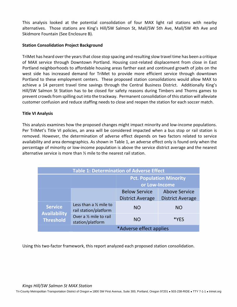
This analysis looked at the potential consolidation of four MAX light rail stations with nearby alternatives. Those stations are King’s Hill/SW Salmon St, Mall/SW 5th Ave, Mall/SW 4th Ave and Skidmore Fountain (See Enclosure B). Station Consolidation Project Background TriMet has heard over the years that close stop spacing and resulting slow travel time has been a critique of MAX service through Downtown Portland. Housing cost-related displacement from close in East Portland neighborhoods to affordable housing areas farther east and continued growth of jobs on the west side has increased demand for TriMet to provide more efficient service through downtown Portland to these employment centers. These proposed station consolidations would allow MAX to achieve a 14 percent travel time savings through the Central Business District. Additionally King’s Hill/SW Salmon St Station has to be closed for safety reasons during Timbers and Thorns games to prevent crowds from spilling out into the trackway. Permanent consolidation of this station will alleviate customer confusion and reduce staffing needs to close and reopen the station for each soccer match. Title VI Analysis This analysis examines how the proposed changes might impact minority and low-income populations. Per TriMet’s Title VI policies, an area will be considered impacted when a bus stop or rail station is removed. However, the determination of adverse effect depends on two factors related to service availability and area demographics. As shown in Table 1, an adverse effect only is found only when the percentage of minority or low-income population is above the service district average and the nearest alternative service is more than ½ mile to the nearest rail station.
Table 1: Determination of Adverse Effect
Pct. Population Minority
or Low-Income
Below Service
District Average Above Service
District Average
Service Availability Threshold
Less than a ½ mile to rail station/platform NO NO
Over a ½ mile to rail station/platform NO *YES
*Adverse effect applies Using this two-factor framework, this report analyzed each proposed station consolidation. Kings Hill/SW Salmon St MAX Station
Tri-County Metropolitan Transportation District of Oregon 1800 SW First Avenue, Suite 300, Portland, Oregon 97201 503-238-RIDE TTY 7-1-1 trimet.org
The study area has a lower-than-average concentration of minority residents compared to the TriMet service district average (29%). There is however, a higher-than-average of low-income residents compared to the TriMet service district average (22%). The impacted area includes four block groups with 5,841 residents (24% minority and 35% low-income). Although the proportion of the area’s population that is low-income exceeds the service district average, the nearby stops (Goose Hollow/SW Jefferson St and Providence Park) are less than a half mile away from the existing King’s Hill stop location. Thus, no adverse effect is found. Mall/SW 5th Ave and Mall/SW 4th Ave Stations The study area has a lower-than-average concentration of minority residents compared to the TriMet service district average (29%). On the other hand, there is a higher-than-average of low-income residents compared to the TriMet service district average (22%). The impacted area includes two block groups with 2,013 residents (23% minority and 60% low-income). Although the proportion of the area’s population that is low-income exceeds the service district average, the nearby stops (Yamhill District, Pioneer Square South and Pioneer Square North) are less than a half mile away from the existing Mall Avenue stop location. Thus, no adverse effect is found. Skidmore Fountain Station The study area has a lower-than-average concentration of minority residents compared to the TriMet service district average (29%). There is however, a higher-than-average of low-income residents compared to the TriMet service district average (22%). The impacted area includes two block groups with 3,490 residents (27% minority and 46% low-income). Although the proportion of the area’s population that is low-income exceeds the service district average, the nearby stations (Oak/1st Ave and Old Town/Chinatown) are less than a half mile away from the existing Skidmore Fountain stop location. Thus, no adverse effect is found. Title VI Analysis Findings Based on the lower-than-average concentration of minority residents in the areas served by the stations proposed for consolidation and the existence of alternative stations within the half mile threshold, the removal of service at the aforementioned stations will not result in a disparate impact for minority populations. Although the study areas surrounding each station have higher-than-average concentrations of low-income residents, the availability of alternative stations less than a half mile away results in there being no disproportionate burden on low-income populations from the MAX Station Optimization proposal. Transit Equity Considerations Public transportation serves an important role of providing affordable mobility across the social and economic spectrum, particularly for large cities across the United States (Griffin and Sener 2016 and Forkenbrock and Sheeley 2004). As the public agency that operates mass transit in the Portland metropolitan area, which includes the most populous parts of Multnomah, Washington, and Clackamas counties, the Tri-County Metropolitan District of Oregon (TriMet) falls under this supposition. As the
Tri-County Metropolitan Transportation District of Oregon 1800 SW First Avenue, Suite 300, Portland, Oregon 97201 503-238-RIDE TTY 7-1-1 trimet.org
region continues to grow, TriMet is seeking out innovative ways to expand service to provide new and better connections to employment, healthcare, education, and other opportunities. Moreover, TriMet is making investments to increase reliability and improve the customer experience for all of its’ riders. A priority area of consideration for TriMet when making decisions to improve access or expand service is transit equity. Continuous attention must be placed on designing a transit system that will work for the region’s most vulnerable populations. This is particularly important for TriMet as many residents of color and low-income populations have moved away from inner city neighborhoods to first ring suburbs. TriMet staff highlight this pattern in a recent post published in TransitCenter’s Ridership Initiative while analyzing ridership loss. This study shows low-income and resident of color shifting from inner NE/SE to east side Portland. At one point, these residents used transit for a diverse array of trips before moving to areas with lower quality transit, while the high-income earners taking their place use transit less frequently even though they live in some of the region’s most transit-rich neighborhoods. In essence, these economic and demographic dynamics put our most loyal transit riders farther away from our best transit service (Mills and Steele 2017). The take away here is inaccessible or low quality transit service presents an equity issue because buses, trains, and other transit services provide the motorized transport necessary for social inclusion and for access to goods, services, and jobs needed for social mobility and economic prosperity (Griffin and Sener 2016). According to a Brooking Institution study, proximity to employment can influence a range of economic and social outcomes, from local fiscal health to the employment prospects of residents, particularly for low-income and minority workers (Kneebone and Holmes 2015). This study also found that as poor and minority residents shifted toward suburbs in the 2000s, their proximity to jobs fell more than for non-poor and white residents. Proximity matters for lower-income, lower-skill workers in particular because they tend to be more constrained by the cost of housing and commuting. Moreover, they are more likely to face spatial barriers to employment, thus their job search areas tend to be smaller and commute distances shorter (Immergluck 1996). In contrast, higher-income, higher-skill workers, who can afford to commute by car and exercise more choice in where they work and live, have more prospects than just the jobs near their neighborhoods and commute longer distances on average (Gabriel and Rosenthal 1996). These aforementioned studies show how external patterns and trends vary for different types of residents and communities with a heightened emphasis on how disadvantaged populations are generally more vulnerable (Kneebone and Holmes 2015). Another equity issue that compounds the challenges placed on people of color and low-income families is slower transit services. (Griffin and Sener 2016 and Bricka 2008). These populations are more likely needing to chain trips to grocery stores with work and transporting children to school and other activities (Christie et al. 2011; Jain, Line, and Lyons 2011; Jiao, Moudon, and Drewnowski 2011; Sanchez et al. 2004). Thus, there is a growing need for strategies to connect low-income and minority residents to economic opportunity due to the growing suburbanization of these populations. Moreover, there is great importance to lessen the impact of travel time in order to advance transit equity and improve upon these existing conditions. One way transit districts can help address these issues is by adopting more integrated and collaborative regional strategies around economic development, transportation, and workforce decisions that take job proximity, commute distance and travel time as well as high quality transit into account. TriMet can do its’ part by providing access to quality transit that is both convenient and fast and responds to the needs of those low-income and minority residents who live farther from employment centers, particularly those hard-hit by dislocation due to housing costs or other factors.
Tri-County Metropolitan Transportation District of Oregon 1800 SW First Avenue, Suite 300, Portland, Oregon 97201 503-238-RIDE TTY 7-1-1 trimet.org
The MAX Station Optimization Project demonstrates TriMet’s commitment to equity and proactive transportation planning. This project seeks to thread a balance of ensuring that the majority those who currently have access to the Red and Blue MAX lines would continue to do so, and meanwhile providing a quicker trip and better connection between people and jobs. Using a more conservative measure of one-quarter mile from the remaining stations, 97% of the walkable area and 94% of buildings remain accessible. For the rider who travels through downtown, assuming a typical round-trip, the time savings adds up to about one full day per year not spent in transit. Community Engagement Plan TriMet discussed the MAX Station Optimization proposal with key stakeholders and community members. These discussions focused on both the benefits and potential impacts of the consolidation proposals. The following provides a summary of activities conducted leading up to the TriMet Board’s decision on whether to approve the four MAX stations consolidation. Initial community outreach included direct mailings to the potentially impacted communities, including all business and residential properties within a ¼ of a mile from each station (See Enclosure C). The notice, invited recipients to call or email TriMet with questions or comments, was mailed to approximately 8,178 neighbors. The letter will also invite them to the September 11 open house in Downtown Portland (See Enclosure D). Phone conversations and in-person meetings occurred August 2018 through March 2019. Fiscal Year 2020 Open Houses, street events, and surveys were also key tools for receiving community feedback. Comments were also collected via the URL trimet.org/maxdowntown. The community outreach summary can be found in the MAX Station Optimization full report. Please feel free to contact me with any questions or comments, [email protected] or ex.5711. Distribution: Shelley Devine, Executive Director, Legal Services Bernie Bottomly, Executive Director, Public Affairs John Gardner, Director Transit Equity, Inclusion, and Community Affairs Kerry Ayres Palanuk, Director Planning & Policy Tom Mills, Manager Service Planning Grant O’Connell, Planner III Clay Thompson, Outreach Services Coordinator
Tri-County Metropolitan Transportation District of Oregon 1800 SW First Avenue, Suite 300, Portland, Oregon 97201 503-238-RIDE TTY 7-1-1 trimet.org
Enclosure A: MAX Route Map

Tri-County Metropolitan Transportation District of Oregon 1800 SW First Avenue, Suite 300, Portland, Oregon 97201 503-238-RIDE TTY 7-1-1 trimet.org
Enclosure B: Proposed Max Station Closures

Tri-County Metropolitan Transportation District of Oregon 1800 SW First Avenue, Suite 300, Portland, Oregon 97201 503-238-RIDE TTY 7-1-1 trimet.org
Enclosure C: Outreach Map
Tri-County Metropolitan Transportation District of Oregon 1800 SW First Avenue, Suite 300, Portland, Oregon 97201 503-238-RIDE TTY 7-1-1 trimet.org
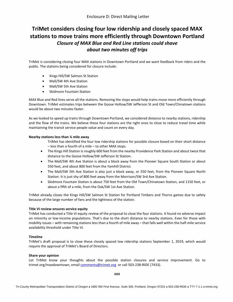
Enclosure D: Direct Mailing Letter
TriMet considers closing four low ridership and closely spaced MAX stations to move trains more efficiently through Downtown Portland
Closure of MAX Blue and Red Line stations could shave about two minutes off trips
TriMet is considering closing four MAX stations in Downtown Portland and we want feedback from riders and the public. The stations being considered for closure include:
• Kings Hill/SW Salmon St Station • Mall/SW 4th Ave Station • Mall/SW 5th Ave Station • Skidmore Fountain Station
MAX Blue and Red lines serve all the stations. Removing the stops would help trains move more efficiently through Downtown. TriMet estimates trips between the Goose Hollow/SW Jefferson St and Old Town/Chinatown stations would be about two minutes faster. As we looked to speed up trains through Downtown Portland, we considered distance to nearby stations, ridership and the flow of the trains. We believe these four stations are the right ones to close to reduce travel time while maintaining the transit service people value and count on every day. Nearby stations less than ¼ mile away
TriMet has identified the four low ridership stations for possible closure based on their short distance – less than a fourth of a mile – to other MAX stops.
• The Kings Hill Station is roughly 600 feet from the nearby Providence Park Station and about twice that distance to the Goose Hollow/SW Jefferson St Station.
• The Mall/SW 4th Ave Station is about a block away from the Pioneer Square South Station or about 550 feet, and about 800 feet from the Yamhill District.
• The Mall/SW 5th Ave Station is also just a block away, or 550 feet, from the Pioneer Square North Station. It is just shy of 800 feet away from the Morrison/SW 3rd Ave Station.
• Skidmore Fountain Station is about 750 feet from the Old Town/Chinatown Station, and 1150 feet, or about a fifth of a mile, from the Oak/SW 1st Ave Station.
TriMet already closes the Kings Hill/SW Salmon St Station for Portland Timbers and Thorns games due to safety because of the large number of fans and the tightness of the station. Title VI review ensures service equity TriMet has conducted a Title VI equity review of the proposal to close the four stations. It found no adverse impact on minority or low-income populations. That’s due to the short distance to nearby stations. Even for those with mobility issues – with remaining stations less than a fourth of mile away – that falls well within the half-mile service availability threshold under Title VI. Timeline TriMet’s draft proposal is to close these closely spaced low ridership stations September 1, 2019, which would require the approval of TriMet’s Board of Directors. Share your opinion Let TriMet know your thoughts about the possible station closures and service improvement. Go to trimet.org/maxdowntown, email [email protected] or call 503-238-RIDE (7433).
###
36
Appendix C – Systems Engineering Report
(see subsequent pages)
Kittelson & Associates, Inc. Portland, Oregon
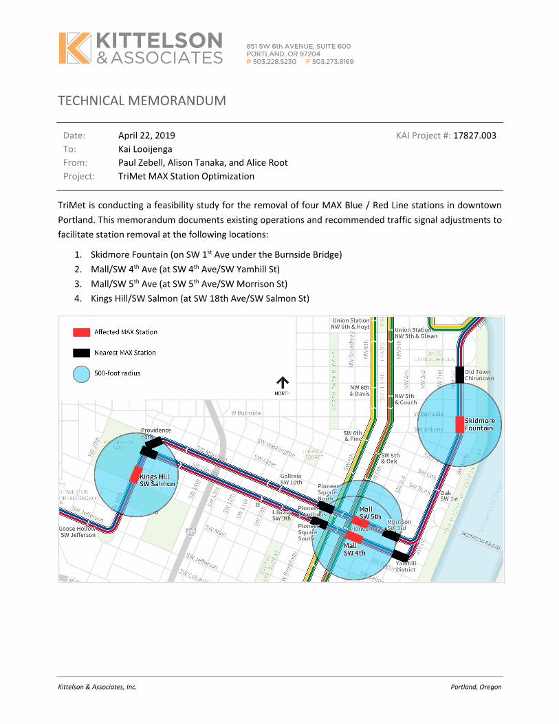
TECHNICAL MEMORANDUM
Date: April 22, 2019 KAI Project #: 17827.003
To: Kai Looijenga
From: Paul Zebell, Alison Tanaka, and Alice Root
Project: TriMet MAX Station Optimization
TriMet is conducting a feasibility study for the removal of four MAX Blue / Red Line stations in downtown
Portland. This memorandum documents existing operations and recommended traffic signal adjustments to
facilitate station removal at the following locations:
1. Skidmore Fountain (on SW 1st Ave under the Burnside Bridge)
2. Mall/SW 4th Ave (at SW 4th Ave/SW Yamhill St)
3. Mall/SW 5th Ave (at SW 5th Ave/SW Morrison St)
4. Kings Hill/SW Salmon (at SW 18th Ave/SW Salmon St)
TriMet MAX Station Optimization KAI Project #: 17827.003 April 2019 Page 2
Kittelson & Associates, Inc. Portland, Oregon
The following equipment is REQUIRED:
• 2070 ATC traffic signal controllers (running Intelight MaxTime firmware) and associated programming
for all station closures.
• Interconnect equipment to connect the controllers (including RuggedCom VDSL modems, isolators,
and wiring) for all station closures.
• TWC loop and bar signal display at SW 4th Ave/SW Morrison St for the Mall/SW 5th Ave MAX Station
closure.
• 337 stretch cabinet at SW 4th Ave/SW Yamhill St for the Mall/SW 4th Ave MAX Station closure.
• Part-time-warning sign at SW 4th Ave/SW Yamhill St for the Mall/SW 4th Ave MAX Station closure.
The following equipment is RECOMMENDED:
• TWC loops for the Skidmore Fountain and Mall/SW 4th Ave MAX Station closures.
• Loop scanners for the Skidmore Fountain, Mall/SW 4th Ave, and Mall/SW 5th Ave MAX Station closures.
• Bar signal displays for the Mall/SW 4th Ave MAX Station closure.
Additional details and rationale are provided throughout the remainder of this memorandum.
Appendix A is a detailed description of operations at SW 5th Ave/SW Morrison St. This location is particularly
critical because of the potential for southbound and westbound trains to conflict at the assumed speed of 15
miles per hour (mph) after the removal of the Mall/SW 5th Ave MAX Station.
Appendix B is a conceptual cost estimate for recommended traffic signal adjustments.
TriMet MAX Station Optimization KAI Project #: 17827.003 April 2019 Page 3
Kittelson & Associates, Inc. Portland, Oregon
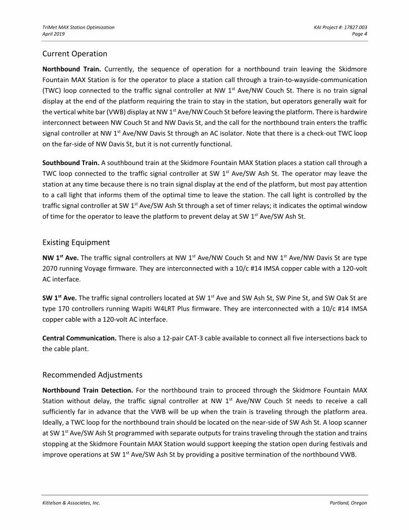
SKIDMORE FOUNTAIN
The MAX stations adjacent to the Skidmore Fountain MAX Station are Old Town/Chinatown to the north and
Oak/SW 1st Ave to the south. The closest signalized intersections are NW 1st Ave/NW Couch St to the north
and SW 1st Ave/SW Ash St to the south. Unlike any of the other locations, the train is not located at a signalized
intersection.
TriMet MAX Station Optimization KAI Project #: 17827.003 April 2019 Page 4
Kittelson & Associates, Inc. Portland, Oregon
Current Operation
Northbound Train. Currently, the sequence of operation for a northbound train leaving the Skidmore
Fountain MAX Station is for the operator to place a station call through a train-to-wayside-communication
(TWC) loop connected to the traffic signal controller at NW 1st Ave/NW Couch St. There is no train signal
display at the end of the platform requiring the train to stay in the station, but operators generally wait for
the vertical white bar (VWB) display at NW 1st Ave/NW Couch St before leaving the platform. There is hardwire
interconnect between NW Couch St and NW Davis St, and the call for the northbound train enters the traffic
signal controller at NW 1st Ave/NW Davis St through an AC isolator. Note that there is a check-out TWC loop
on the far-side of NW Davis St, but it is not currently functional.
Southbound Train. A southbound train at the Skidmore Fountain MAX Station places a station call through a
TWC loop connected to the traffic signal controller at SW 1st Ave/SW Ash St. The operator may leave the
station at any time because there is no train signal display at the end of the platform, but most pay attention
to a call light that informs them of the optimal time to leave the station. The call light is controlled by the
traffic signal controller at SW 1st Ave/SW Ash St through a set of timer relays; it indicates the optimal window
of time for the operator to leave the platform to prevent delay at SW 1st Ave/SW Ash St.
Existing Equipment
NW 1st Ave. The traffic signal controllers at NW 1st Ave/NW Couch St and NW 1st Ave/NW Davis St are type
2070 running Voyage firmware. They are interconnected with a 10/c #14 IMSA copper cable with a 120-volt
AC interface.
SW 1st Ave. The traffic signal controllers located at SW 1st Ave and SW Ash St, SW Pine St, and SW Oak St are
type 170 controllers running Wapiti W4LRT Plus firmware. They are interconnected with a 10/c #14 IMSA
copper cable with a 120-volt AC interface.
Central Communication. There is also a 12-pair CAT-3 cable available to connect all five intersections back to
the cable plant.
Recommended Adjustments
Northbound Train Detection. For the northbound train to proceed through the Skidmore Fountain MAX
Station without delay, the traffic signal controller at NW 1st Ave/NW Couch St needs to receive a call
sufficiently far in advance that the VWB will be up when the train is traveling through the platform area.
Ideally, a TWC loop for the northbound train should be located on the near-side of SW Ash St. A loop scanner
at SW 1st Ave/SW Ash St programmed with separate outputs for trains traveling through the station and trains
stopping at the Skidmore Fountain MAX Station would support keeping the station open during festivals and
improve operations at SW 1st Ave/SW Ash St by providing a positive termination of the northbound VWB.
TriMet MAX Station Optimization KAI Project #: 17827.003 April 2019 Page 5
Kittelson & Associates, Inc. Portland, Oregon
A TWC loop installed on the near-side of NW 1st Ave/NW Davis St is recommended to provide NW Davis St
with a positive termination of the northbound VWB.
The existing check-out detector on the far-side of NW Davis St is not currently functional and should be
repaired (although that maintenance cost is not included in the following cost estimate).
Northbound TWC loops would:
• Allow a northbound train to recall the VWB at SW Ash St and NW Davis St if the train did not make it
through the intersections
• Allow a more efficient check-out for a northbound train at SW Ash St and NW Davis St (reducing overall
vehicle delay)
• Allow a shorter maximum VWB time programmed for a northbound train at NW Couch St (reducing
overall vehicle delay)
Southbound Train Detection. For the southbound train, a TWC loop installed near-side at NW 1st Ave/NW
Couch St is recommended to provide a pre-call to SW 1st Ave/SW Ash St, which will supplement a call from
the present TWC loop at the Skidmore Fountain MAX Station. A loop scanner at NW 1st Ave/NW Couch St
programmed with separate outputs for southbound trains traveling through and trains stopping at the
Skidmore Fountain MAX Station would support keeping the station open during festivals and improve
operations at NW 1st Ave/NW Couch St by providing positive termination of the southbound VWB.
Southbound TWC loops would:
• Allow a southbound train to recall the signal at NW Couch St if the train did not make it through the
intersection
• Allow a more efficient check-out for the southbound train at NW Couch St (reducing overall vehicle
delay)
• Allow a shorter maximum VWB time programmed for a southbound train at SW Ash St (reducing
overall vehicle delay)
Traffic Signal Controllers. The traffic signal controllers at NW 1st Ave/NW Couch St and SW 1st Ave/SW Ash St
should be upgraded to type 2070 ATC running Intelight MaxTime firmware to facilitate peer-to-peer
communication.
Traffic Signal Timing and Logic. Traffic signal timing will need to be programmed in the new controllers at NW
1st Ave/NW Couch St and SW 1st Ave/SW Ash St, and logic will need to be developed to account for the part-
time use of the station. Some traffic signal timing and logic adjustments will also be required at NW 1st
Ave/NW Davis St for northbound trains.
Interconnect. RuggedCom VDSL modems are recommended at NW 1st Ave/NW Couch St and SW 1st Ave/SW
Ash St so that the existing 12-pair CAT-3 cable back to the cable plant can be utilized for peer-to-peer
communication between the intersections. Isolators and wiring will be required to connect the new
TriMet MAX Station Optimization KAI Project #: 17827.003 April 2019 Page 6
Kittelson & Associates, Inc. Portland, Oregon
controllers at NW 1st Ave/NW Couch St and SW 1st Ave/SW Ash St to the older controllers at NW 1st Ave/NW
Davis St and SW 1st Ave/SW Pine St.
Passenger Wayfinding. Festival use of the Skidmore Fountain MAX Station is possible with the recommended
adjustments to equipment and traffic signal timing. However, messaging for riders about the part-time use of
the station will be important.
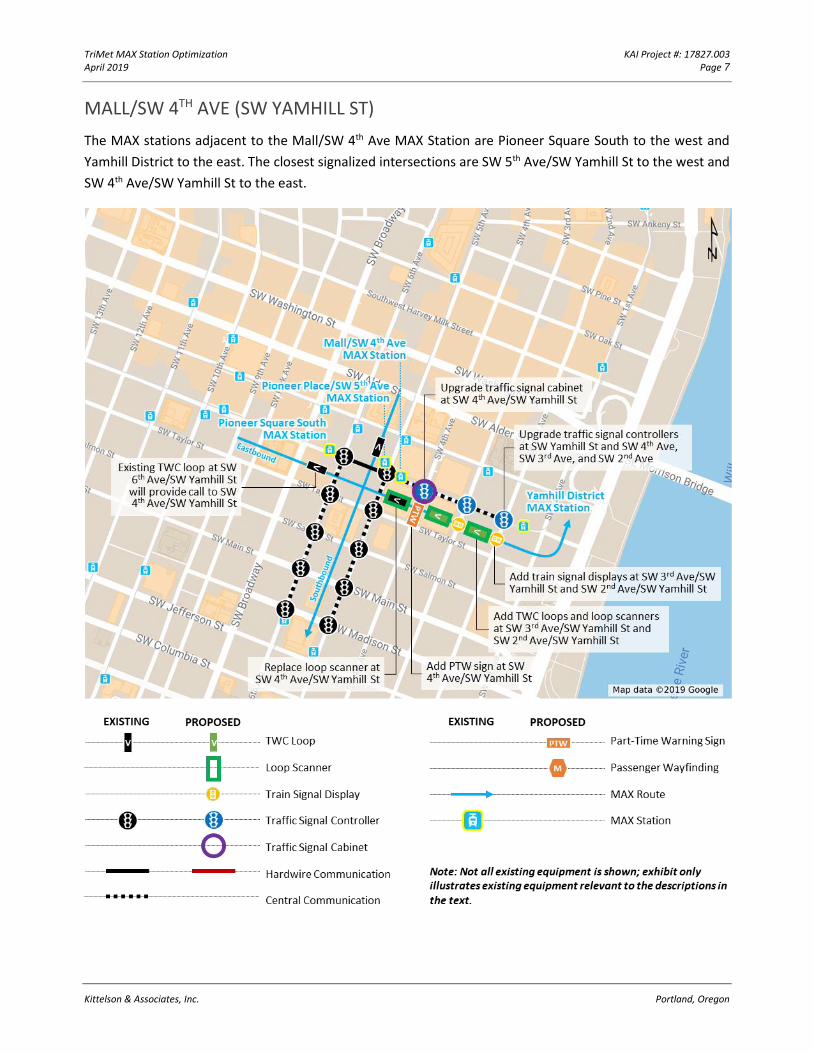
TriMet MAX Station Optimization KAI Project #: 17827.003 April 2019 Page 7
Kittelson & Associates, Inc. Portland, Oregon
MALL/SW 4TH AVE (SW YAMHILL ST)
The MAX stations adjacent to the Mall/SW 4th Ave MAX Station are Pioneer Square South to the west and
Yamhill District to the east. The closest signalized intersections are SW 5th Ave/SW Yamhill St to the west and
SW 4th Ave/SW Yamhill St to the east.
TriMet MAX Station Optimization KAI Project #: 17827.003 April 2019 Page 8
Kittelson & Associates, Inc. Portland, Oregon
Current Operation
Eastbound Train. The eastbound train at the Mall/SW 4th Ave MAX Station places a station call through a TWC
loop connected to the traffic signal controller at SW 4th Ave/SW Yamhill St. The traffic signal controller
provides the VWB at the normal start of green. There are no train signal displays at SW 3rd Ave/SW Yamhill St
or SW 2nd Ave/SW Yamhill St, and the train proceeds with the vehicle green signal displays without the benefit
of preemption.
Southbound Train. The southbound train at the Pioneer Place/SW 5th Ave MAX Station places a station call
through a TWC loop connected to the traffic signal controller at SW 5th Ave/SW Yamhill St. The traffic signal
controller provides the VWB at the normal start of green after the end of the eastbound preempt. The call is
cascaded to downstream intersections on SW 5th Ave using FSK modems on a 12-pair CAT-3 cable.
Existing Equipment
SW 5th Ave. System 3 includes the following intersections along SW 5th Ave: SW Yamhill St, SW Taylor St, SW
Salmon St, SW Main St, and SW Madison St. All five intersections have traffic signal controllers that are type
2070 running Voyage firmware. They are interconnected with 12-pair CAT-3 cable between FSK modems that
cascade the preemption call from one intersection to the next.
SW 6th Ave. System 10 is made up of the following intersections along SW 6th Ave: SW Yamhill St, SW Taylor
St, SW Salmon St, SW Main St, and SW Madison St. All five intersections have traffic signal controllers that are
type 2070 running Voyage firmware. They are interconnected with 12-pair CAT-3 cable between FSK modems
that cascade the preemption call from one intersection to the next.
SW Yamhill St. It is not possible for a Voyage controller to be a part of two systems, so there is hardwire
interconnect between System 3 and System 10 that connects SW 5th Ave/SW Yamhill St to SW 6th Ave/SW
Yamhill St. The system to the east of SW 5th Ave/SW Yamhill St includes SW 4th Ave/SW Yamhill St, SW 3rd
Ave/SW Yamhill St, and SW 2nd Ave/SW Yamhill St. Those three intersections have traffic signal controllers
that are type 170 running Wapiti W9FT firmware.
Central Communication. There is an existing 12-pair CAT-3 cable installed between SW 5th Ave/SW Yamhill St
and SW 2nd Ave/SW Yamhill St that connects the intersections back to the cable plant.
Recommended Adjustments
Eastbound Train Detection. For an eastbound train to proceed through the Mall/SW 4th Ave MAX Station
without delay, SW 4th Ave/SW Yamhill St needs to receive a call sufficiently far in advance so the VWB will be
up when the train is traveling through the platform area. An existing TWC loop for the eastbound train at SW
6th Ave/SW Yamhill St is located far enough in advance for this operation.
TriMet MAX Station Optimization KAI Project #: 17827.003 April 2019 Page 9
Kittelson & Associates, Inc. Portland, Oregon
TWC loops and loop scanners are recommended for near-side installation at SW 3rd Ave/SW Yamhill St and
SW 2nd Ave/SW Yamhill St to provide check-out and back-up calls. While not required, replacing the loop
scanner at SW 4th Ave/SW Yamhill St is also recommended.
Combined with the installation of VWB displays, eastbound TWC loops would:
• Allow an eastbound train to recall the VWB at SW 3rd Ave and SW 2nd Ave if the train did not make it
through the intersections
• Allow a more efficient check-out for an eastbound train at SW 3rd Ave and SW 2nd Ave (reducing overall
vehicle delay)
• Allow a shorter maximum split time for the eastbound movement at SW 3rd Ave and SW 2nd Ave
(reducing overall vehicle delay)
Eastbound Train Displays. Bar signals are recommended at SW 3rd Ave/SW Yamhill St and SW 2nd Ave/SW
Yamhill St to support preemption of the traffic signals and extension of the VWB.
Traffic Signal Controllers. The traffic signal controllers at SW 4th Ave/SW Yamhill St, SW 3rd Ave/SW Yamhill
St, and SW 2nd Ave/SW Yamhill St should be upgraded to type 2070 ATC running MaxTime Intelight firmware
to facilitate peer-to-peer communication.
Traffic Signal Cabinets. The traffic signal cabinet at SW 4th Ave/SW Yamhill St should be upgraded to type 337S
to accommodate the additional equipment being installed.
Traffic Signal Timing and Logic. Traffic signal timing will need to be programmed in the new controllers at SW
4th Ave/SW Yamhill St, SW 3rd Ave/SW Yamhill St, and SW 2nd Ave/SW Yamhill St, and logic will need to be
developed for the PTW sign, train signal displays, and preemption.
Interconnect. RuggedCom VDSL modems are recommended at SW Yamhill St and SW 4th Ave, SW 3rd Ave, and
SW 2nd Ave so that the existing 12-pair CAT-3 cable back to the cable plant can be utilized for peer-to-peer
communication between the intersections. Isolators and wiring will be required to connect the new controller
at SW 4th Ave/SW Yamhill St to the older controllers at SW 6th Ave/SW Yamhill St and SW 5th Ave/SW Yamhill
St.
Eastbound Vehicle Part-Time Warning Sign. A part-time warning (PTW) sign, in addition to the current static
no-turn-on-red signs, is recommended at SW 4th Ave/SW Yamhill St to warn vehicles turning left onto SW 4th
Ave from SW Yamhill St when a train is approaching. The new PTW sign would activate prior to a through train
at SW 4th Ave when the VWB is up and the eastbound vehicle signals are red.
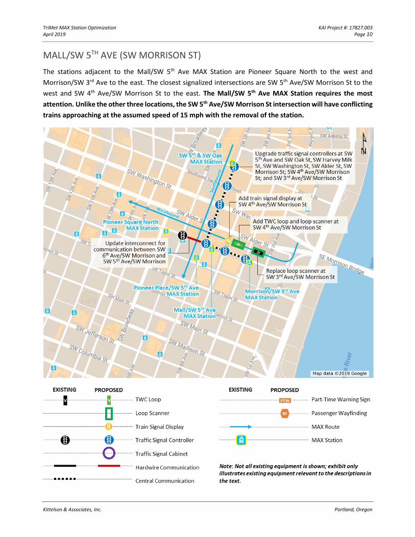
TriMet MAX Station Optimization KAI Project #: 17827.003 April 2019 Page 10
Kittelson & Associates, Inc. Portland, Oregon
MALL/SW 5TH AVE (SW MORRISON ST)
The stations adjacent to the Mall/SW 5th Ave MAX Station are Pioneer Square North to the west and
Morrison/SW 3rd Ave to the east. The closest signalized intersections are SW 5th Ave/SW Morrison St to the
west and SW 4th Ave/SW Morrison St to the east. The Mall/SW 5th Ave MAX Station requires the most
attention. Unlike the other three locations, the SW 5th Ave/SW Morrison St intersection will have conflicting
trains approaching at the assumed speed of 15 mph with the removal of the station.
TriMet MAX Station Optimization KAI Project #: 17827.003 April 2019 Page 11
Kittelson & Associates, Inc. Portland, Oregon
Current Operation
Westbound Train. A westbound train at the Morrison/SW 3rd Ave MAX Station places a station call through a
TWC loop connected to the traffic signal controller at SW 3rd Ave/SW Morrison St. The traffic signal controller
provides the VWB at the normal start of green. There is no train signal display at SW 4th Ave/SW Morrison St,
and the train proceeds with the vehicle green signal displays into the Mall/SW 5th Ave MAX Station without
the benefit of preemption.
Southbound Train. A southbound train at the SW 5th & SW Oak MAX Station places a station call through a
TWC loop connected to the traffic signal controller at SW 5th Ave/SW Oak St. The traffic signal controller
provides the VWB at the normal start of green and cascades the call to downstream intersections on SW 5th
Ave.
Because of the regular grid pattern of one-way streets through Portland’s downtown, traffic signals are
coordinated with a quarter-cycle offset between each intersection that allows traffic to progress in all four
directions. When a train places a call for service at a station, the traffic signal controller waits until the normal
start of green to display the VWB and then cascades the call to downstream intersections. The VWB at each
intersection is held until either the back of the train enters the intersection or the signal reaches a maximum
time.
The maximum time allowed for the VWB display at each intersection increases as the train moves away from
a station. The maximum time allowed at SW 5th Ave/SW Oak St is 9 seconds, and the maximum time allowed
at SW 5th Ave/SW Morrison St is 30 seconds. This allows a train that has been delayed between stations to
still make it to the next station during the same cycle. Most trains do not use the maximum available VWB
time and terminate (check out) the traffic signal long before that, allowing progression to be maintained.
A train departing from SW 5th Ave/SW Oak St that is delayed prior to arriving at SW 5th Ave/SW Alder St can
reasonably expect to still have the VWB signal display at SW 5th Ave/SW Morrison St (during the time usually
reserved for the westbound movement). Similarly, a train departing from SW 3rd Ave/SW Morrison St that is
delayed prior to arriving at SW 4th Ave/SW Morrison St can reasonably expect to still have the VWB signal
display at SW 5th Ave/SW Morrison St (during the time usually reserved for the southbound movement).
A detailed case study of westbound and southbound trains traveling towards SW 5th Ave/SW Morrison St is
described in Appendix A; this scenario will inform the logic and timing of the two respective train movements.
Existing Equipment
SW Morrison St. The traffic signal controllers at SW 4th Ave/ SW Morrison St and SW 3rd Ave/ SW Morrison St
are type 170 controllers running Wapiti W9FT firmware.
SW 5th Ave. The traffic signal controllers along SW 5th Ave at SW Oak St, SW Harvey Milk St, SW Washington
St, SW Alder St, and SW Morrison St are type 2070 controllers running Voyage firmware. These intersections
TriMet MAX Station Optimization KAI Project #: 17827.003 April 2019 Page 12
Kittelson & Associates, Inc. Portland, Oregon
are connected through existing RuggedCom VDSL modems and the 12-pair CAT-3 cable back to the cable
plant.
Central Communication. There is an existing 12-pair CAT-3 cable installed between SW 5th Ave/SW Morrison
St and SW 3rd Ave/SW Morrison St that connects the intersections back to the cable plant.
Recommended Adjustments
Westbound Train Detection. For a westbound train to proceed through the Mall/SW 5th Ave MAX Station
without delay, SW 5th Ave/ SW Morrison St needs to receive a call sufficiently far in advance so the VWB will
be up when the train is traveling through the platform area. Existing detection for the westbound train at SW
3rd Ave/SW Morrison St is located far enough in advance for this operation; however, installation of a TWC
loop at SW 4th Ave/SW Morrison St would be a valuable addition for positive termination of a westbound VWB
(recommended below). While not required, replacing the loop scanner at SW 3rd Ave/SW Morrison St is also
recommended.
Combined with the installation of a VWB display, a westbound TWC loop is CRITICAL to:
• Allow the westbound train to recall the signal at SW 4th Ave in the event that a westbound train is
stopped to prevent a conflict with a southbound train (as explained in Appendix A)
• Allow a more efficient check-out for the westbound train at SW 4th Ave (reducing overall vehicle delay)
Westbound Train Displays. A bar signal is recommended at SW 4th Ave/SW Morrison St to support preemption
of the traffic signal and extension of the VWB.
Combined with a TWC loop, a westbound bar signal is CRITICAL to:
• Control the westbound train movement in order to maintain adequate separation between
southbound and westbound trains (as explained in Appendix A).
Traffic Signal Controllers. The traffic signal controllers along SW 5th Ave at SW Oak St, SW Harvey Milk St, SW
Washington St, SW Alder St, SW Morrison St; SW 4th Ave/SW Morrison St; and SW 3rd Ave/SW Morrison St will
need to be upgraded to type 2070 ATC running Intelight MaxTime firmware to facilitate peer-to-peer
communication.
Traffic Signal Timing and Logic. Traffic signal timing will need to be programmed in the new controllers along
SW 5th Ave at SW Oak St, SW Harvey Milk St, SW Washington St, SW Alder St, SW Morrison St; SW 4th Ave/SW
Morrison St; and SW 3rd Ave/SW Morrison St.
If traffic signal controllers on SW 5th Ave or SW Morrison St are in transition (due to preemption, train delays,
or last-minute adjustments), a method is needed to maintain acceptable separation between the two trains
approaching SW 5th Ave/SW Morrison St at the same time. The conflict monitor at SW 5th Ave/SW Morrison
St (or any intersection) will not allow conflicting displays. However, stopping a train at SW 5th Ave/SW
TriMet MAX Station Optimization KAI Project #: 17827.003 April 2019 Page 13
Kittelson & Associates, Inc. Portland, Oregon
Morrison St does not provide separation, so it is recommended that trains be stopped at the previous
intersections (SW 5th Ave/SW Alder St in the southbound direction and SW 4th Ave/SW Morrison St in the
westbound direction). This will ensure that operators receive horizontal amber bars (HABs) at two
intersections prior to a potential conflict.
Traffic signal controller logic in combination with peer-to-peer communication between the seven
intersections could accomplish this separation without introducing unnecessary delay. Delays can be avoided
if the westbound train is stopped at SW 4th Ave/SW Morrison St unless the southbound train has already
checked out of SW 5th Ave/SW Alder St. Similarly, delays can be avoided if the southbound train is stopped at
SW 5th Ave/SW Alder St unless the westbound train has already checked out of SW 4th Ave/SW Morrison St.
Interconnect. RuggedCom VDSL modems are recommended along SW 5th Ave at SW Oak St, SW Harvey Milk
St, SW Washington St, SW Alder St, SW Morrison St; SW 4th Ave/SW Morrison St; and SW 3rd Ave/SW Morrison
St so that the existing 12-pair CAT-3 cable back to the cable plant can be utilized for peer-to-peer
communication between the intersections. Isolators and wiring will be required to connect the new controller
at SW 5th Ave/SW Morrison St to the older controller at SW 6th Ave/SW Morrison St.
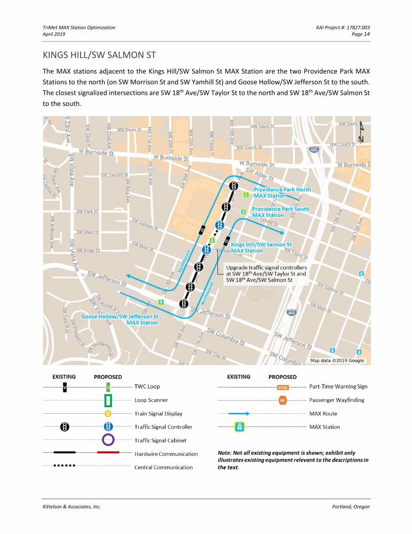
TriMet MAX Station Optimization KAI Project #: 17827.003 April 2019 Page 14
Kittelson & Associates, Inc. Portland, Oregon
KINGS HILL/SW SALMON ST
The MAX stations adjacent to the Kings Hill/SW Salmon St MAX Station are the two Providence Park MAX
Stations to the north (on SW Morrison St and SW Yamhill St) and Goose Hollow/SW Jefferson St to the south.
The closest signalized intersections are SW 18th Ave/SW Taylor St to the north and SW 18th Ave/SW Salmon St
to the south.
TriMet MAX Station Optimization KAI Project #: 17827.003 April 2019 Page 15
Kittelson & Associates, Inc. Portland, Oregon
Current Operation
Southbound Train. Currently, the southbound train at the Kings Hill/SW Salmon St MAX Station places a call
through a TWC loop connected to the traffic signal controller at SW 18th Ave/SW Salmon St. The traffic signal
controller immediately enters preemption, which prompts the southbound VWB and cascades the call to SW
18th Ave/SW Jefferson St.
Northbound Train. The northbound train at the Kings Hill/SW Salmon St MAX Station places a station call
through a TWC loop connected to the traffic controller at SW 18th Ave/SW Taylor St. When the traffic signal
controller provides the VWB, the call is cascaded to SW 18th Ave/SW Yamhill St.
Existing Equipment
SW 18th Ave. The traffic signal controllers along SW 18th Ave at SW Morrison St, SW Yamhill St, SW Taylor St,
SW Salmon St, SW Main St, SW Madison St, and SW Jefferson St are type 2070 running Voyage firmware (of
various older versions). Preemption calls are cascaded south from SW 18th Ave/SW Salmon St and north from
SW 18th Ave/SW Taylor St through DC isolators connected with 10/c #14 IMSA copper cable.
Central Communication. The intersections also have unmanaged VDSL modems connected with a 12-pair
CAT-3 cable. This cable runs along SW 18th Ave for communication back to the cable plant.
Recommended Adjustments
Traffic Signal Controllers. Traffic signal controllers at SW 18th Ave/SW Salmon St and SW 18th Ave/SW Taylor
St will need to be upgraded to type 2070 ATC running Intelight MaxTime firmware to facilitate peer-to-peer
communication
Traffic Signal Timing and Logic. Traffic signal timing will need to be programmed in the new controllers at SW
18th Ave/SW Salmon St and SW 18th Ave/SW Taylor St. Some signal timing and logic adjustments may be
required at the other intersections depending on the interconnect upgrades (as noted below).
Interconnect. RuggedCom VDSL modems are recommended at SW 18th Ave/SW Salmon St and SW 18th
Ave/SW Taylor St so that the existing 12-pair CAT-3 cable back to the cable plant can be utilized for peer-to-
peer communication between the intersections. Isolators and wiring will be required to connect the new
controllers at SW 18th Ave/SW Salmon St and SW 18th Ave/SW Taylor St to the older controllers at SW 18th
Ave/SW Main St and SW 18th Ave/SW Yamhill St. Some isolators and wiring upgrades may also be required at
the other intersections.
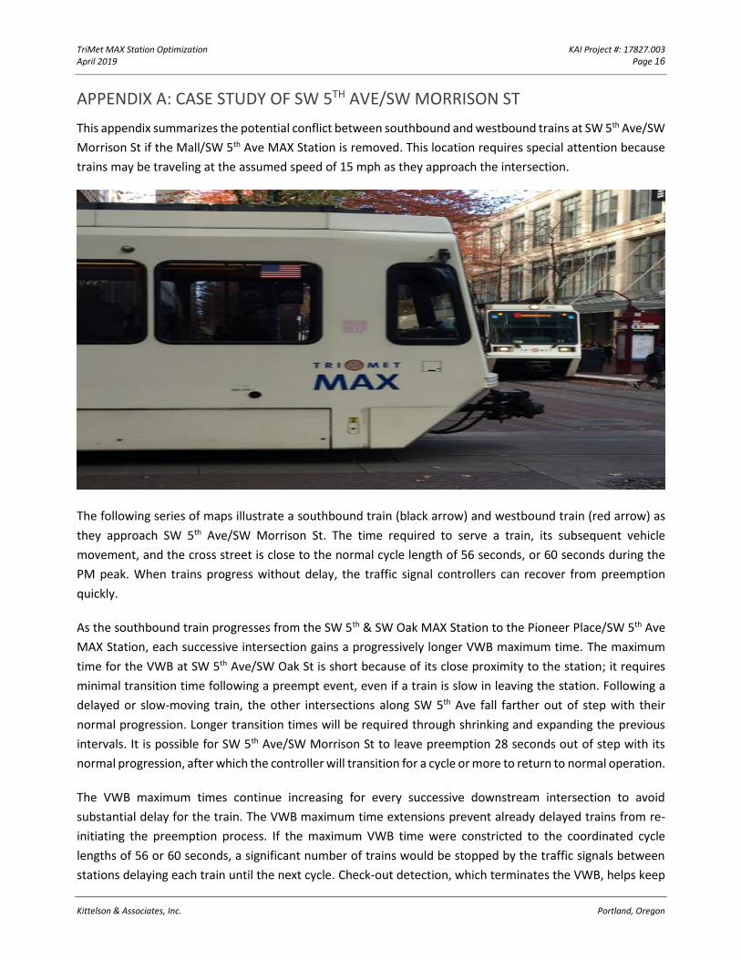
TriMet MAX Station Optimization KAI Project #: 17827.003 April 2019 Page 16
Kittelson & Associates, Inc. Portland, Oregon
APPENDIX A: CASE STUDY OF SW 5TH AVE/SW MORRISON ST
This appendix summarizes the potential conflict between southbound and westbound trains at SW 5th Ave/SW
Morrison St if the Mall/SW 5th Ave MAX Station is removed. This location requires special attention because
trains may be traveling at the assumed speed of 15 mph as they approach the intersection.
The following series of maps illustrate a southbound train (black arrow) and westbound train (red arrow) as
they approach SW 5th Ave/SW Morrison St. The time required to serve a train, its subsequent vehicle
movement, and the cross street is close to the normal cycle length of 56 seconds, or 60 seconds during the
PM peak. When trains progress without delay, the traffic signal controllers can recover from preemption
quickly.
As the southbound train progresses from the SW 5th & SW Oak MAX Station to the Pioneer Place/SW 5th Ave
MAX Station, each successive intersection gains a progressively longer VWB maximum time. The maximum
time for the VWB at SW 5th Ave/SW Oak St is short because of its close proximity to the station; it requires
minimal transition time following a preempt event, even if a train is slow in leaving the station. Following a
delayed or slow-moving train, the other intersections along SW 5th Ave fall farther out of step with their
normal progression. Longer transition times will be required through shrinking and expanding the previous
intervals. It is possible for SW 5th Ave/SW Morrison St to leave preemption 28 seconds out of step with its
normal progression, after which the controller will transition for a cycle or more to return to normal operation.
The VWB maximum times continue increasing for every successive downstream intersection to avoid
substantial delay for the train. The VWB maximum time extensions prevent already delayed trains from re-
initiating the preemption process. If the maximum VWB time were constricted to the coordinated cycle
lengths of 56 or 60 seconds, a significant number of trains would be stopped by the traffic signals between
stations delaying each train until the next cycle. Check-out detection, which terminates the VWB, helps keep
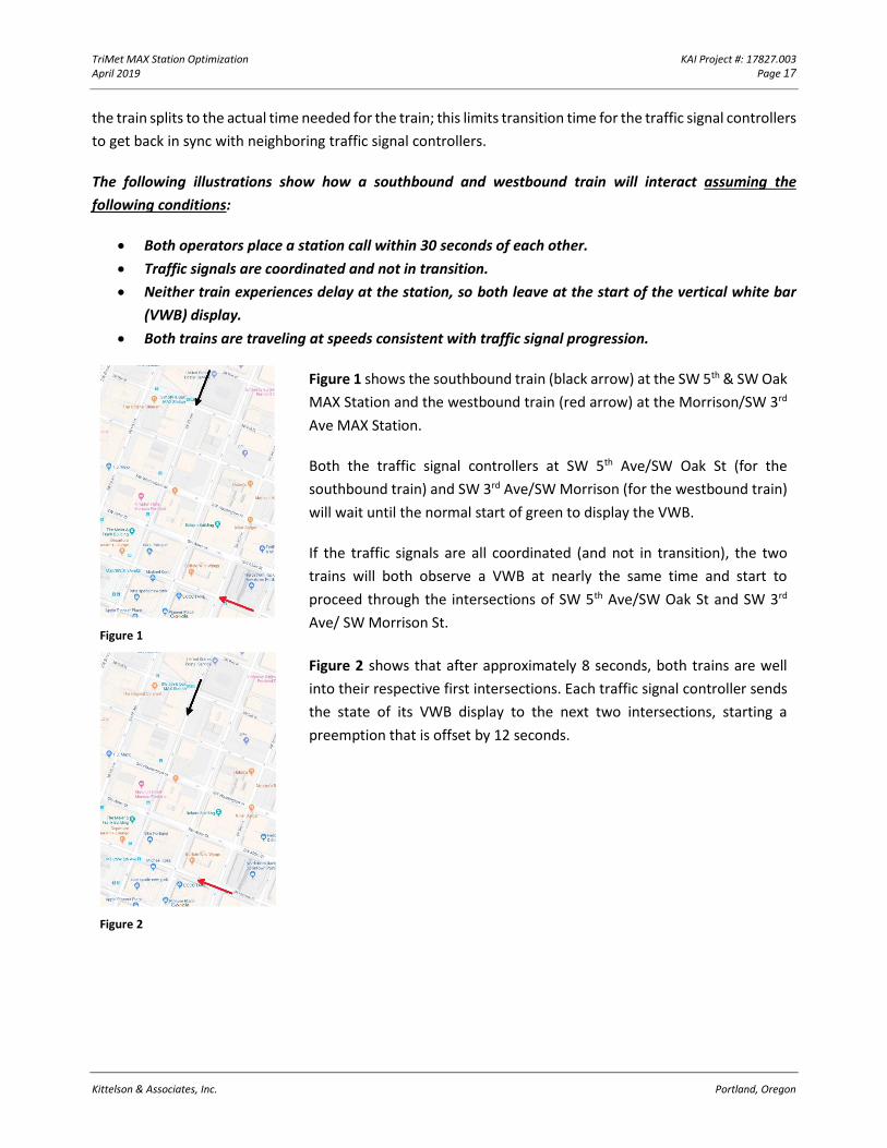
TriMet MAX Station Optimization KAI Project #: 17827.003 April 2019 Page 17
Kittelson & Associates, Inc. Portland, Oregon
the train splits to the actual time needed for the train; this limits transition time for the traffic signal controllers
to get back in sync with neighboring traffic signal controllers.
The following illustrations show how a southbound and westbound train will interact assuming the
following conditions:
• Both operators place a station call within 30 seconds of each other.
• Traffic signals are coordinated and not in transition.
• Neither train experiences delay at the station, so both leave at the start of the vertical white bar
(VWB) display.
• Both trains are traveling at speeds consistent with traffic signal progression.
Figure 1
Figure 1 shows the southbound train (black arrow) at the SW 5th & SW Oak
MAX Station and the westbound train (red arrow) at the Morrison/SW 3rd
Ave MAX Station.
Both the traffic signal controllers at SW 5th Ave/SW Oak St (for the
southbound train) and SW 3rd Ave/SW Morrison (for the westbound train)
will wait until the normal start of green to display the VWB.
If the traffic signals are all coordinated (and not in transition), the two
trains will both observe a VWB at nearly the same time and start to
proceed through the intersections of SW 5th Ave/SW Oak St and SW 3rd
Ave/ SW Morrison St.
Figure 2
Figure 2 shows that after approximately 8 seconds, both trains are well
into their respective first intersections. Each traffic signal controller sends
the state of its VWB display to the next two intersections, starting a
preemption that is offset by 12 seconds.
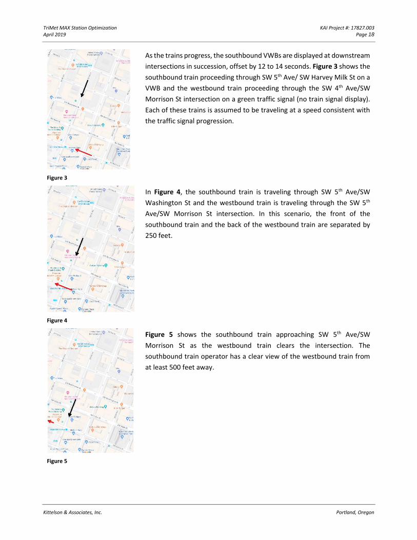
TriMet MAX Station Optimization KAI Project #: 17827.003 April 2019 Page 18
Kittelson & Associates, Inc. Portland, Oregon
Figure 3
As the trains progress, the southbound VWBs are displayed at downstream
intersections in succession, offset by 12 to 14 seconds. Figure 3 shows the
southbound train proceeding through SW 5th Ave/ SW Harvey Milk St on a
VWB and the westbound train proceeding through the SW 4th Ave/SW
Morrison St intersection on a green traffic signal (no train signal display).
Each of these trains is assumed to be traveling at a speed consistent with
the traffic signal progression.
Figure 4
In Figure 4, the southbound train is traveling through SW 5th Ave/SW
Washington St and the westbound train is traveling through the SW 5th
Ave/SW Morrison St intersection. In this scenario, the front of the
southbound train and the back of the westbound train are separated by
250 feet.
Figure 5
Figure 5 shows the southbound train approaching SW 5th Ave/SW
Morrison St as the westbound train clears the intersection. The
southbound train operator has a clear view of the westbound train from
at least 500 feet away.
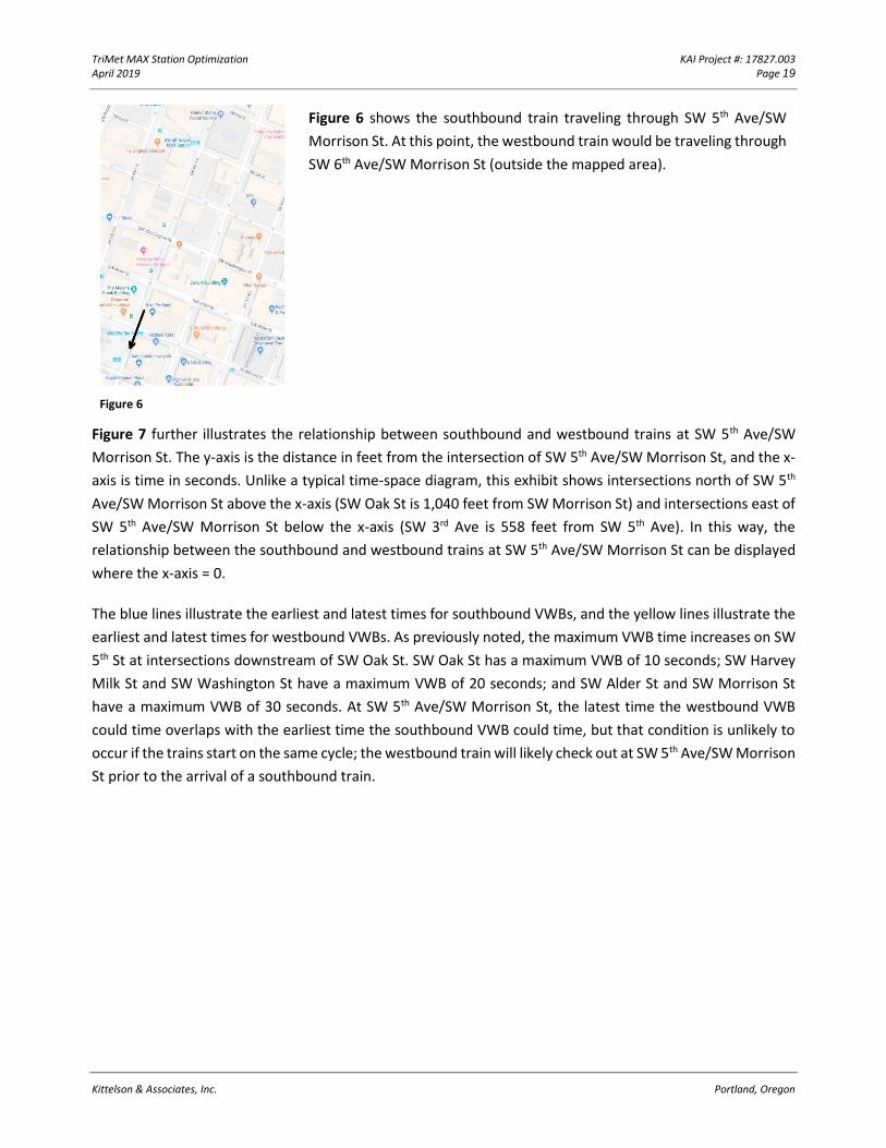
TriMet MAX Station Optimization KAI Project #: 17827.003 April 2019 Page 19
Kittelson & Associates, Inc. Portland, Oregon
Figure 6
Figure 6 shows the southbound train traveling through SW 5th Ave/SW
Morrison St. At this point, the westbound train would be traveling through
SW 6th Ave/SW Morrison St (outside the mapped area).
Figure 7 further illustrates the relationship between southbound and westbound trains at SW 5th Ave/SW
Morrison St. The y-axis is the distance in feet from the intersection of SW 5th Ave/SW Morrison St, and the x-
axis is time in seconds. Unlike a typical time-space diagram, this exhibit shows intersections north of SW 5th
Ave/SW Morrison St above the x-axis (SW Oak St is 1,040 feet from SW Morrison St) and intersections east of
SW 5th Ave/SW Morrison St below the x-axis (SW 3rd Ave is 558 feet from SW 5th Ave). In this way, the
relationship between the southbound and westbound trains at SW 5th Ave/SW Morrison St can be displayed
where the x-axis = 0.
The blue lines illustrate the earliest and latest times for southbound VWBs, and the yellow lines illustrate the
earliest and latest times for westbound VWBs. As previously noted, the maximum VWB time increases on SW
5th St at intersections downstream of SW Oak St. SW Oak St has a maximum VWB of 10 seconds; SW Harvey
Milk St and SW Washington St have a maximum VWB of 20 seconds; and SW Alder St and SW Morrison St
have a maximum VWB of 30 seconds. At SW 5th Ave/SW Morrison St, the latest time the westbound VWB
could time overlaps with the earliest time the southbound VWB could time, but that condition is unlikely to
occur if the trains start on the same cycle; the westbound train will likely check out at SW 5th Ave/SW Morrison
St prior to the arrival of a southbound train.
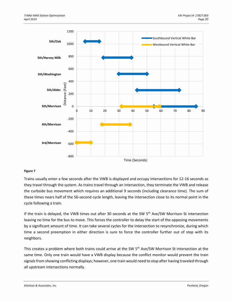
TriMet MAX Station Optimization KAI Project #: 17827.003 April 2019 Page 20
Kittelson & Associates, Inc. Portland, Oregon
Figure 7
Trains usually enter a few seconds after the VWB is displayed and occupy intersections for 12-16 seconds as
they travel through the system. As trains travel through an intersection, they terminate the VWB and release
the curbside bus movement which requires an additional 9 seconds (including clearance time). The sum of
these times nears half of the 56-second cycle length, leaving the intersection close to its normal point in the
cycle following a train.
If the train is delayed, the VWB times out after 30 seconds at the SW 5th Ave/SW Morrison St intersection
leaving no time for the bus to move. This forces the controller to delay the start of the opposing movements
by a significant amount of time. It can take several cycles for the intersection to resynchronize, during which
time a second preemption in either direction is sure to force the controller further out of step with its
neighbors.
This creates a problem where both trains could arrive at the SW 5th Ave/SW Morrison St intersection at the
same time. Only one train would have a VWB display because the conflict monitor would prevent the train
signals from showing conflicting displays; however, one train would need to stop after having traveled through
all upstream intersections normally.
-800
-600
-400
-200
0
200
400
600
800
1000
1200
0 10 20 30 40 50 60 70 80 90
Dis
tan
ce (
Feet
)
Time (Seconds)
Southbound Vertical White Bar
Westbound Vertical White Bar5th/Oak
5th/Harvey Milk
5th/Washington
5th/Alder
5th/Morrison
4th/Morrison
3rd/Morrison
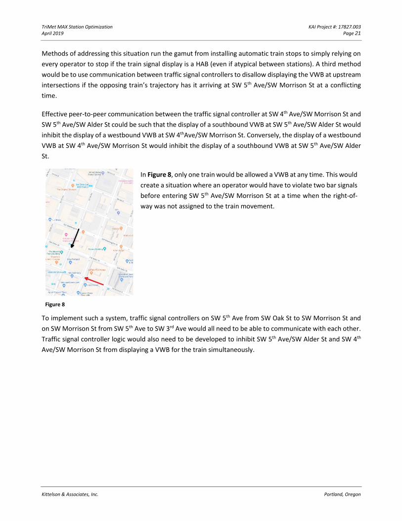
TriMet MAX Station Optimization KAI Project #: 17827.003 April 2019 Page 21
Kittelson & Associates, Inc. Portland, Oregon
Methods of addressing this situation run the gamut from installing automatic train stops to simply relying on
every operator to stop if the train signal display is a HAB (even if atypical between stations). A third method
would be to use communication between traffic signal controllers to disallow displaying the VWB at upstream
intersections if the opposing train’s trajectory has it arriving at SW 5th Ave/SW Morrison St at a conflicting
time.
Effective peer-to-peer communication between the traffic signal controller at SW 4th Ave/SW Morrison St and
SW 5th Ave/SW Alder St could be such that the display of a southbound VWB at SW 5th Ave/SW Alder St would
inhibit the display of a westbound VWB at SW 4thAve/SW Morrison St. Conversely, the display of a westbound
VWB at SW 4th Ave/SW Morrison St would inhibit the display of a southbound VWB at SW 5th Ave/SW Alder
St.
Figure 8
In Figure 8, only one train would be allowed a VWB at any time. This would
create a situation where an operator would have to violate two bar signals
before entering SW 5th Ave/SW Morrison St at a time when the right-of-
way was not assigned to the train movement.
To implement such a system, traffic signal controllers on SW 5th Ave from SW Oak St to SW Morrison St and
on SW Morrison St from SW 5th Ave to SW 3rd Ave would all need to be able to communicate with each other.
Traffic signal controller logic would also need to be developed to inhibit SW 5th Ave/SW Alder St and SW 4th
Ave/SW Morrison St from displaying a VWB for the train simultaneously.
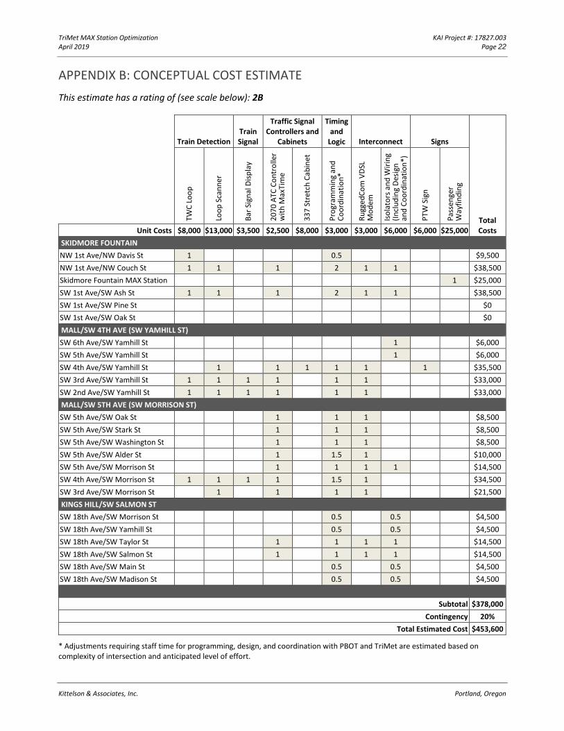
TriMet MAX Station Optimization KAI Project #: 17827.003 April 2019 Page 22
Kittelson & Associates, Inc. Portland, Oregon
APPENDIX B: CONCEPTUAL COST ESTIMATE
This estimate has a rating of (see scale below): 2B
Train Detection Train Signal
Traffic Signal Controllers and
Cabinets
Timing and
Logic Interconnect Signs
Total Costs
TWC
Lo
op
Lo
op
Sca
nn
er
Bar
Sig
nal
Dis
pla
y
20
70
ATC
Co
ntr
olle
r w
ith
Max
Tim
e
33
7 S
tret
ch C
abin
et
Pro
gram
min
g an
d
Co
ord
inat
ion
*
Ru
gged
Co
m V
DSL
M
od
em
Iso
lato
rs a
nd
Wir
ing
(In
clu
din
g D
esig
n
and
Co
ord
inat
ion
*)
PTW
Sig
n
Pas
sen
ger
Way
fin
din
g
Unit Costs $8,000 $13,000 $3,500 $2,500 $8,000 $3,000 $3,000 $6,000 $6,000 $25,000
SKIDMORE FOUNTAIN
NW 1st Ave/NW Davis St 1 0.5 $9,500
NW 1st Ave/NW Couch St 1 1 1 2 1 1 $38,500
Skidmore Fountain MAX Station 1 $25,000
SW 1st Ave/SW Ash St 1 1 1 2 1 1 $38,500
SW 1st Ave/SW Pine St $0
SW 1st Ave/SW Oak St $0
MALL/SW 4TH AVE (SW YAMHILL ST)
SW 6th Ave/SW Yamhill St 1 $6,000
SW 5th Ave/SW Yamhill St 1 $6,000
SW 4th Ave/SW Yamhill St 1 1 1 1 1 1 $35,500
SW 3rd Ave/SW Yamhill St 1 1 1 1 1 1 $33,000
SW 2nd Ave/SW Yamhill St 1 1 1 1 1 1 $33,000
MALL/SW 5TH AVE (SW MORRISON ST)
SW 5th Ave/SW Oak St 1 1 1 $8,500
SW 5th Ave/SW Stark St 1 1 1 $8,500
SW 5th Ave/SW Washington St 1 1 1 $8,500
SW 5th Ave/SW Alder St 1 1.5 1 $10,000
SW 5th Ave/SW Morrison St 1 1 1 1 $14,500
SW 4th Ave/SW Morrison St 1 1 1 1 1.5 1 $34,500
SW 3rd Ave/SW Morrison St 1 1 1 1 $21,500
KINGS HILL/SW SALMON ST
SW 18th Ave/SW Morrison St 0.5 0.5 $4,500
SW 18th Ave/SW Yamhill St 0.5 0.5 $4,500
SW 18th Ave/SW Taylor St 1 1 1 1 $14,500
SW 18th Ave/SW Salmon St 1 1 1 1 $14,500
SW 18th Ave/SW Main St 0.5 0.5 $4,500
SW 18th Ave/SW Madison St 0.5 0.5 $4,500
Subtotal $378,000
Contingency 20%
Total Estimated Cost $453,600
* Adjustments requiring staff time for programming, design, and coordination with PBOT and TriMet are estimated based on complexity of intersection and anticipated level of effort.
TriMet MAX Station Optimization KAI Project #: 17827.003 April 2019 Page 23
Kittelson & Associates, Inc. Portland, Oregon
Scope Accuracy:
• Level 1: Project scope well understood and well defined.
• Level 2: Project scope conceptual. Scope lacks detail due to potential permit requirements; unknown
project conditions; limited knowledge of external impacts.
• Level 3: Project scope is a "vision" with limited detail.
Engineering Effort:
• Level A: Preliminary engineering performed. Technical information is available; engineering
calculations have been performed; clear understanding of the materials, size, and quantities needed
to execute job. Schedule understood; staff and permitting is fairly clear (however this element may
still need refining). Project development and construction contingencies range between 10%-20%.
• Level B: Conceptual engineering performed. Technical information is available, rough engineering
calculations may have been performed, or similar information from previous similar work is compared
and used. Project development contingencies range between 15% to 25%, and construction
contingencies range between 20% to 30%.
• Level C: No engineering performed. Educated guesstimating. Limited technical information available
and/or analysis performed. Project development and construction contingencies should be selected
appropriately by project manager. Contingency may range up to 50%.