Embed Size (px)
Citation preview
CONSERVATION RESERVES MANAGEMENT STRATEGY
January 2003
Parks Victoria
CONSERVATION RESERVES MANAGEMENT STRATEGY
Parks Victoria
January 2003
2
This strategy for managing Conservation Reserves has been approved for implementation. The strategy establishes for the first time a strategic approach that Parks Victoria staff can apply to the management of individual Conservation Reserves. By setting overarching management directions including guiding principles, the strategy will enable Parks Victoria to significantly improve management of reserves.
Its purpose is to set directions and strategies to guide management of the full range of activities undertaken in reserves. The strategy establishes strategic management objectives for Parks Victoria’s four output areas, which can be applied to all three categories of Conservation Reserves— Nature Conservation Reserves, Natural Features Reserves, and Historic and Cultural Features Reserves. In addition it provides a strategic priority ranking of Conservation Reserves, based on environmental values to guide the programming of management activities.
The Conservation Reserves Management Strategy is also a key document, which details the available information about environmental, historic and indigenous values and visitor facilities in Conservation Reserves and clarifies gaps in knowledge about the reserve estate. Development of the strategy was undertaken jointly with the Department of Sustainability and Environment and involved input from Parks Victoria staff including staff responsible for the management of Conservation Reserves.
Published in January 2003 by Parks Victoria
Level 10, 535 Bourke Street Melbourne, Victoria, 3000
Bibliography.
ISBN 0 7311 8332 0
Disclaimer:
Every effort has been made to ensure that the information in this strategy is accurate. Parks Victoria does not guarantee that the publication is without flaw of any kind and therefore disclaims all liability for any error, loss or other consequence which may arise from you relying on any information in the publication.
Cover: From left, Korong Vale Bushland Reserve (NFR), aerial and vegetation of Little Dalyenong Flora Reserve (NCR). (Photographs Rhonda Bullock)

3
CONTENTS
1 INTRODUCTION 1
1.1 Background 1
1.2 Purpose 3
1.3 LCC and ECC recommendations and legislation 4
1.4 Categories of conservation reserves 7
2 MANAGEMENT OBJECTIVES 8
2.1 Nature Conservation Reserves 9
2.2 Natural Features Reserves 10
2.3 Historic and Cultural Features Reserves 11
3 OVERVIEW OF THE RESERVE ESTATE 13
3.1 Overview of the reserve estate 13
3.2 Assessment of management activity 33
3.3 Information gaps and data limitations 36
4 MANAGEMENT DIRECTIONS 41
5 STRATEGIES FOR IMPLEMENTATION 46
5.1 Legislative and management arrangements 46
5.2 Reserve priorities 47
5.3 Planning and work programs for individual reserves 48
5.4 Information collection and management 49
5.5 Community and stakeholder partnerships 50
5.6 Education and public awareness 51
5.7 Reporting and performance measurement frameworks 52
REFERENCES 53
APPENDICES 54
1 Reserve Management Statement 54
2 Criteria for reserves requiring management plans 57
3 Priority reserves 58
4
FIGURES
1 Areas managed by Parks Victoria 2
2 The percentage of reserves of each category by district 16
3 Number of conservation reserves by size class 17
4 Percentage area of each conservation reserve category by district 18
5 Number of important, rare and large EVCs in conservation reserves 21
6 Number of conservation reserves by recorded fauna diversity class 22
7 Number of conservation reserves by threatened fauna class 23
8 Number of conservation reserves by flora diversity class 25
9 Number of conservation reserves by threatened flora class 26
10 Number of conservation reserves with wetlands in each category 28
11 Limitations of EVC mapping for Little Dalyenong Flora Reserve (NCR) 38
TABLES
1 Types of parks comprising the parks and reserves system 3
2 Reservation status of conservation reserves 6
3 Categories of conservation reserves 7
4 Number and area of each conservation reserve category 13
5 Number of reserves within each LCC/ECC category 14
6 Number and area of reserves of each category in each region and district 15
7 Number of conservation reserves by size and connectivity class 19
8 Number of threatened EVCs in conservation reserves 20
9 Number and percentage of conservation reserves in each category with fauna records 22
10 Number and percentage of conservation reserves in each category with threatened fauna records
23
11 Number of highest priority fauna records and number of reserves with highest priority fauna species for each district 24
12 Number and percentage of conservation reserves in each category with flora records 25
13 Number and percentage of conservation reserves in each category with threatened flora records 26
14 Number of highest priority flora records and number of reserves with highest priority flora species for each district 27
15 Number and percentage of conservation reserves in each category with threatened flora and fauna records 27
16 Number of conservation reserves in each category with wetlands 28
17 Number and percentage of conservation reserves with historic places and total number and percentage of places for each category 29
18 Number and percentage of conservation reserves with known Indigenous sites for each category 29

5
19 Conservation reserves with the highest number of each Indigenous site type 30
20 Number and percentage of conservation reserves with known Aboriginal historical placesfor each category 31
21 Visitor numbers for conservation reserves with at least one visitor site 31
22 Conservation reserves with over 50 000 visitors per year 32
23 Levels of service for conservation reserves with at least one visitor site 33
24 Level of activity (operating budget) by key output areas for 1999–2000 33
25 Percentage of conservation reserves (operating budget) for each reserve type 34
26 Level of activity (expenditure) by output areas for 2000-2001 35
27 Level of activity (operating budget) by output areas for 2001–2002 36
MAPS
1 Number of Conservation Reserves End of report
2 Area of Conservation Reserves End of report
6
1
1 INTRODUCTION
This report is presented in five parts:
• an introduction explaining the relevant background and context for the management of Conservation Reserves by Parks Victoria including a description of the categories of Conservation Reserves;
• an outline of the overarching management objectives, and activities and uses permitted in reserves;
• a section reviewing the available information for reserves including an overview of the number and area of reserves, the environmental, historic and indigenous values, and visitor services in the reserves, an assessment of the current level of management activity in reserves, and information gaps and data limitations;
• a section detailing future management directions for Conservation Reserves; and
• a section documenting statewide management strategies to address a range of actions that will lead to an overall improvement in the management of reserves.
This section details the relevant background information about Conservation Reserves in Victoria, documents the aims of this strategy, and outlines the legislative context for managing reserves and the categories of reserves managed by Parks Victoria.
1.1 BACKGROUND
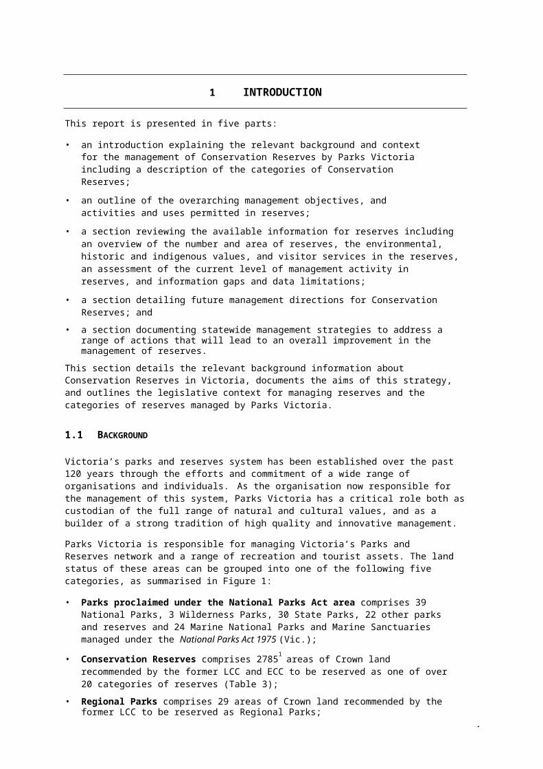
Victoria’s parks and reserves system has been established over the past 120 years through the efforts and commitment of a wide range of organisations and individuals. As the organisation now responsible for the management of this system, Parks Victoria has a critical role both as custodian of the full range of natural and cultural values, and as a builder of a strong tradition of high quality and innovative management.
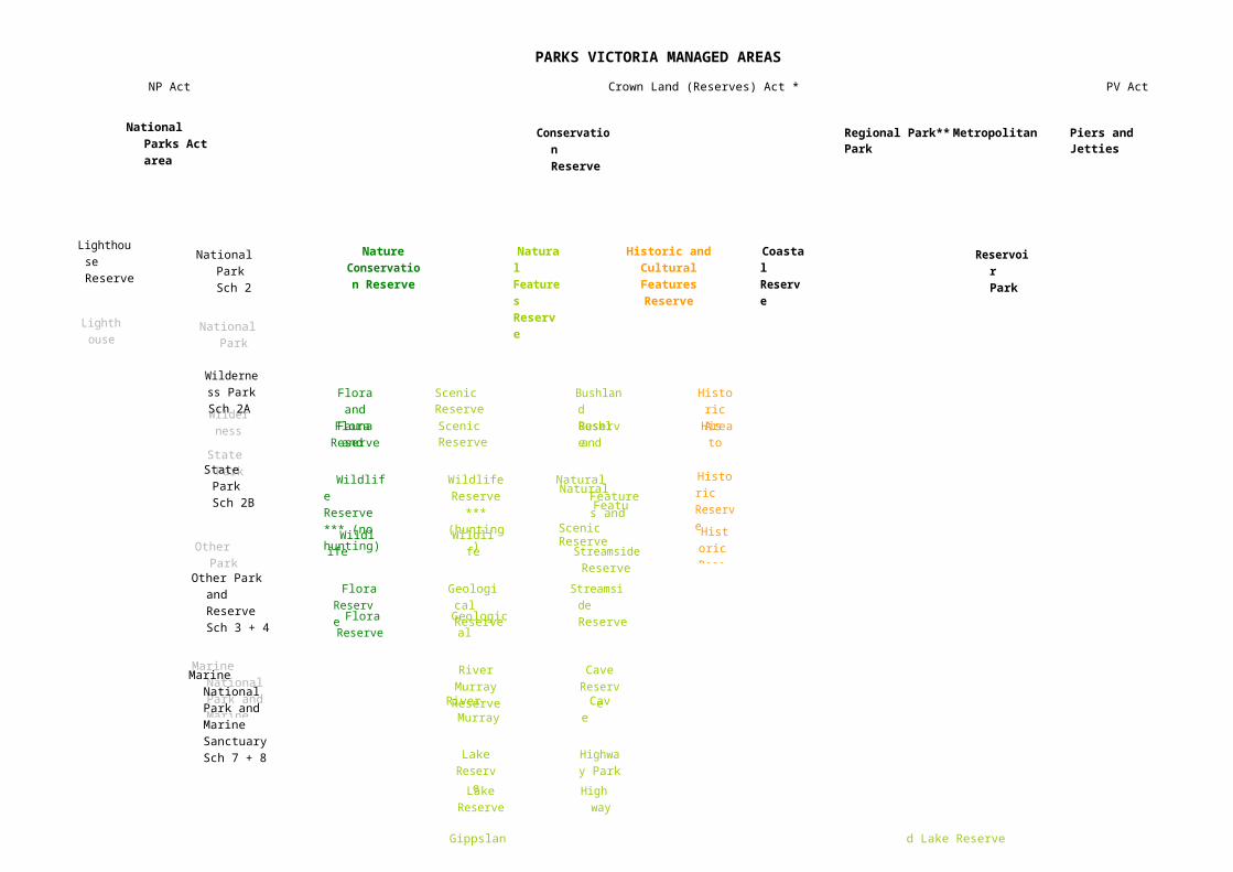
Parks Victoria is responsible for managing Victoria’s Parks and Reserves network and a range of recreation and tourist assets. The land status of these areas can be grouped into one of the following five categories, as summarised in Figure 1:
• Parks proclaimed under the National Parks Act area comprises 39 National Parks, 3 Wilderness Parks, 30 State Parks, 22 other parks and reserves and 24 Marine National Parks and Marine Sanctuaries managed under the National Parks Act 1975 (Vic.);
• Conservation Reserves comprises 27851 areas of Crown land recommended by the former LCC and ECC to be reserved as one of over 20 categories of reserves (Table 3);
• Regional Parks comprises 29 areas of Crown land recommended by the former LCC to be reserved as Regional Parks;
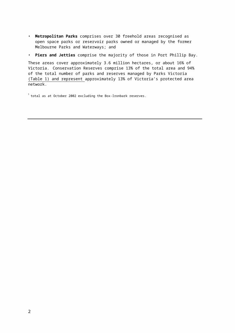
• Metropolitan Parks comprises over 30 freehold areas recognised as open space parks or reservoir parks owned or managed by the former Melbourne Parks and Waterways; and
• Piers and Jetties comprise the majority of those in Port Phillip Bay.
These areas cover approximately 3.6 million hectares, or about 16% of Victoria. Conservation Reserves comprise 13% of the total area and 94% of the total number of parks and reserves managed by Parks Victoria (Table 1) and represent approximately 13% of Victoria’s protected area network.
1 total as at October 2002 excluding the Box-Ironbark reserves.

2 FIGURE
1
ARE
A SM A N A GED BYP A RKS
V IC T
ORIA
State Park Sch
National Park Sch 2
Wilderness
Park
Other Park and Reserve
Wildlife Reserve *** (no
Flora Reserve
Flora and
Fauna
Scenic Reserve
Wildlife Reserve
***
Geological Reserve
River Murray R
Lake Reserve
Gippsland Lake
Bushland
Natural Features
Streamside Reserve
Cave Res
Highway
Education
Historic
Historic Res
Lighthouse
Marine National Park and Marine Sanctuary
PARKS VICTORIA MANAGED AREASNP Act Crown Land (Reserves) Act * PV Act
National Parks Act area
Conservation Reserve
Regional Park** Metropolitan Park Piers and Jetties
Lighthouse Reserve National
Park Sch 2
Nature Conservation
Reserve
Natural Features Reserve
Historic and Cultural Features Reserve
Coastal Reserve
Reservoir Park
Wilderness Park
Sch 2AFlora and
Fauna Reserve
Scenic Reserve Bushland Reserve
Historic Area
State Park Sch 2B
Wildlife Reserve *** (no hunting)
Wildlife Reserve ***
(hunting)
Natural Features and
Scenic Reserve
Historic Reserve
Other Park and Reserve Sch 3 + 4
Flora Reserve
Geological Reserve
Streamside Reserve
Marine National Park and Marine Sanctuary Sch 7 + 8
River Murray
Reserve
Lake Reserve
Cave Reserve
Highway Park
Gippsland Lake Reserve
Education Area****
KEY LEGISLATIVE OVERLAYS
Wilderness Zone (NP Act)
Heritage River or Natural Catchment Area (Heritage Rivers Act) * and/or VEAC
Act
** Forests Act mayRemote and Natural Area*****(NP Act)
Education Area (VEAC Act)
Wildlife Management Co-operative
Area (CL Reserves Act) Reference Areas
(Reference Areas Act)
Ramsar Site (EPBC Act)
apply
*** Wildlife Act also applies**** includes Serendip Wetlands Education Facility***** includes
three outside NP Act areas
3
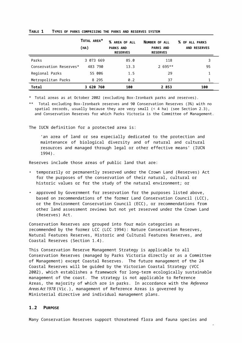
TABLE 1 TYPES OF PARKS COMPRISING THE PARKS AND RESERVES SYSTEM
TOTAL AREA* % AREA OF ALL
NUMBER OF ALL
% OF ALL PARKS
(HA) PARKS AND PARKS AND AND RESERVESRESERVES RESERVES
Parks 3 073 669 85.0 118 3
Conservation Reserves* 483 790 13.3 2 695** 95
Regional Parks 55 006 1.5 29 1
Metropolitan Parks 8 295 0.2 37 1
Total 3 620 760 100 2 853 100
* Total areas as at October 2002 (excluding Box-Ironbark parks and reserves).** Total excluding Box-Ironbark reserves and 90 Conservation Reserves (3%) with no spatial records, usually
because they are very small (< 4 ha) (see Section 2.3), and Conservation Reserves for which Parks Victoria is the Committee of Management.
The IUCN definition for a protected area is:
‘an area of land or sea especially dedicated to the protection and maintenance of biological diversity and of natural and cultural resources and managed through legal or other effective means’ (IUCN 1994).
Reserves include those areas of public land that are:
• temporarily or permanently reserved under the Crown Land (Reserves) Act for the purposes of the conservation of their natural, cultural or historic values or for the study of the natural environment; or
• approved by Government for reservation for the purposes listed above, based on recommendations of the former Land Conservation Council (LCC), or the Environment Conservation Council (ECC), or recommendations from other land assessment reviews but not yet reserved under the Crown Land (Reserves) Act.
Conservation Reserves are grouped into four main categories as recommended by the former LCC (LCC 1994): Nature Conservation Reserves, Natural Features Reserves, Historic and Cultural Features Reserves, and Coastal Reserves (Section 1.4).
This Conservation Reserve Management Strategy is applicable to all Conservation Reserves (managed by Parks Victoria directly or as a Committee of Management) except Coastal Reserves. The future management of the 24 Coastal Reserves will be guided by the Victorian Coastal Strategy (VCC 2002), which establishes a framework for long-term ecologically sustainable management of the coast. The strategy is not applicable to Reference Areas, the majority of which are in parks. In accordance with the Reference Areas Act 1978 (Vic.), management of Reference Areas is governed by Ministerial directive and individual management plans.
1.2 PURPOSE
Many Conservation Reserves support threatened flora and fauna species and communities or contain features of historical and cultural significance. Some are included on the Register of the National Estate and have wetlands in the list of wetlands of international importance under the Convention on Wetlands (Ramsar, Iran 1971) also known as the Ramsar Convention or the Directory of Important Wetlands (EA 2001). Conservation Reserves also provide opportunities for recreation and, in some limited cases, sustainable use of natural and cultural resources under licence or lease.
Parks Victoria needs a clear basis for allocating resources to the core business of the management of natural and cultural resources and to visitor services, both for the areas reserved and managed under the National Parks Act 1975 (Vic.) and for areas reserved under the Crown Land (Reserves) Act 1978 (Vic.).
4
5
Strategic Plans in the form of Management Plans provide the overall direction for the management of individual parks reserved under the National Parks Act. The need to develop management strategies to protect and enhance the environmental, cultural and recreational values of each park is highlighted in these plans and is a core responsibility for Parks Victoria.
Management plans have been prepared for only a small number of Conservation Reserves particularly those with high natural values. Due to the large number of Conservation Reserves, Parks Victoria and the Department of Natural Resources and Environment have agreed that generally individual plans will not be prepared for the Conservation Reserves managed by Parks Victoria. Instead, it is proposed that this Conservation Reserves Management Strategy will facilitate the development of strategic management objectives to provide a sound basis for programming management activity in those reserves.
The Conservation Reserves Management Strategy will:
• encompass the full range of activities undertaken in reserves under Parks Victoria’s key output areas—natural values management, heritage values management, indigenous values management, and visitor services;
• establish a strategic priority ranking of Conservation Reserves, based on environmental values to guide the programming of management activities;
• establish a range of strategic management objectives for the four output areas, which will be suitable for all types of Conservation Reserves; and
• set directions and strategies for Parks Victoria staff to use in the development of management objectives for individual reserves.
In addition, development of the strategy will enable:
• review of available sources of information;
• identification of information gaps and data limitations;
• development of an overview of the Conservation Reserve estate;
• improved understanding of the three categories of reserves— Nature Conservation Reserves, Natural Features Reserves, and Historic and Cultural Features Reserves; and
• understanding of the current level of management activity.
1.3 LCC AND ECC RECOMMENDATIONS AND LEGISLATION
LCC/ECC1 Recommendations
The majority of Conservation Reserves were established as a result of LCC and ECC recommendations for the use of public land. The remainder were established as a result of land purchase or other assessment programs.
Upon Government approval of LCC/ECC recommendations the relevant land manager is bound to manage the reserve in accordance with those recommendations until it is formally reserved as such. This is effected:
• under Section 10(3) of the repealed Land Conservation Act 1970 (Vic.), which was saved in Section 26 of the Environment Conservation Council Act 1997 (Vic.). This requires Government departments ‘to use all diligence … to give effect to such recommendations … and manage the areas accordingly until implemented’. Similarly, Section 26 of the Victorian Environment Assessment Council Act 2001 (Vic.) states that if the Government wholly or partly accepts a recommendation, the Government 'must ensure that appropriate actions are taken to implement
1 the former Land Conservation Council (LCC) became the Environment Conservation Council (ECC) in 1997, and then subsequently became the Victorian Environment Assessment Council (VEAC) in 2001.
6
the recommendation to the extent that it has been accepted’. Further, a savings clause provides that repeal of the ECC Act does not affect the continuing operation of ECC or LCC recommendations.
• by a general recommendation included in recent LCC/ECC final reports such as R11 in the Box– Ironbark Forests and Woodlands Investigation (ECC 2001).
The general recommendations for each conservation reserve category (and, in some cases, additional specific recommendations for individual conservation reserves) apply. If a Government-approved LCC/ECC recommendation applies to a reserve and is inconsistent with the existing reservation purpose, the area should be managed in accordance with the LCC/ECC recommendation.
Generally Governments have approved nearly all LCC/ECC recommendations. The VEAC is aiming to have all the final recommendations, edited for Government variations, available on their website in 2002. In addition the VEAC is compiling a database, also to be accessed via the website in 2002, that lists the approval dates and variations made by Government for all the recommendations.
Some of the LCC recommendations are now considered out of date; for example, the 1980 recommendations for off-road driving in the Anglesea heathlands. In these instances interpretation of the LCC recommendations should be sought. Where interpretation does not clarify matters, or implementation of the Government accepted LCC/ECC recommendation is likely to cause intractable and significant management problems, VEAC can be asked to review a recommendation. Any request to VEAC is subject to the approval of Parks Victoria's Chief Executive Officer and DSE's Executive Director of Parks, Flora and Fauna.
The land status of a reserve can be complex but the LCC/ECC recommendation often simplifies matters. For example, the new St Arnaud RP resulting from the ECC Box–Ironbark Investigation currently comprises four township blocks (variously reserved or unreserved Crown land), one bushland reserve and two historic and cultural features reserves (reserved under the Crown Land Reserves Act) and an area of State forest. Regardless of whether Land Victoria has formally reserved these areas as a regional park, the land managers (initially Parks Victoria and DSE's Forest Division) must manage the areas in accordance with the general recommendation for regional parks and the specific Government-accepted recommendations for St Arnaud RP. This recommends use for informal recreation, conservation of biodiversity and natural features, and protection of significant historic sites and Aboriginal cultural sites and places. A number of activities are generally permitted and some, such as timber harvesting, grazing and car rallies, are prohibited.
Legislation
Section 4 of the Crown Land (Reserves) Act provides for the Governor in Council to reserve Crown land temporarily or permanently for a range of public purposes. Conservation Reserves are generally reserved by gazettal under Section 4(1) (l), (m), (n), (o) or (p) for: the preservation of areas of ecological significance; the conservation of areas of natural interest or beauty or of scientific, historic or archaeological interest; the preservation of species of native plants; or the propagation or management of wildlife or the preservation of wildlife habitat respectively. Some individual conservation reserves may be reserved for other purposes under Section 4(1) to reflect unique management requirements. Approximately 40% of Conservation Reserves are reserved under the Crown Land (Reserves) Act) as recommended by the LCC/ECC (Table 2).
The Crown Land (Reserves) Act also gives direction to committees of management to manage land for the purposes for which it is reserved. Land Victoria, DSE is responsible for overseeing those reserves managed by committees of management, however Parks Victoria is the committee of management for a small number of reserves, for example court houses on Historic and Cultural Features Reserves.

7
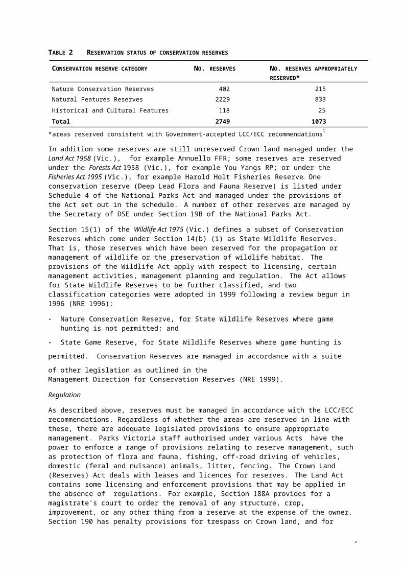
TABLE 2 RESERVATION STATUS OF CONSERVATION RESERVES
CONSERVATION RESERVE CATEGORY NO. RESERVES NO. RESERVES APPROPRIATELY RESERVED*
Nature Conservation Reserves 402 215
Natural Features Reserves 2229 833
Historical and Cultural Features Reserves 118 25
Total 2749 1073
* areas reserved consistent with Government-accepted LCC/ECC recommendations1
In addition some reserves are still unreserved Crown land managed under the Land Act 1958 (Vic.), for example Annuello FFR; some reserves are reserved under the Forests Act 1958 (Vic.), for example You Yangs RP; or under the Fisheries Act 1995 (Vic.), for example Harold Holt Fisheries Reserve. One conservation reserve (Deep Lead Flora and Fauna Reserve) is listed under Schedule 4 of the National Parks Act and managed under the provisions of the Act set out in the schedule. A number of other reserves are managed by the Secretary of DSE under Section 19B of the National Parks Act.
Section 15(1) of the Wildlife Act 1975 (Vic.) defines a subset of Conservation Reserves which come under Section 14(b) (i) as State Wildlife Reserves. That is, those reserves which have been reserved for the propagation or management of wildlife or the preservation of wildlife habitat. The provisions of the Wildlife Act apply with respect to licensing, certain management activities, management planning and regulation. The Act allows for State Wildlife Reserves to be further classified, and two classification categories were adopted in 1999 following a review begun in 1996 (NRE 1996):
• Nature Conservation Reserve, for State Wildlife Reserves where game hunting is not permitted; and
• State Game Reserve, for State Wildlife Reserves where game hunting is permitted.
Conservation Reserves are managed in accordance with a suite of other legislation as outlined in theManagement Direction for Conservation Reserves (NRE 1999).
Regulation
As described above, reserves must be managed in accordance with the LCC/ECC recommendations. Regardless of whether the areas are reserved in line with these, there are adequate legislated provisions to ensure appropriate management. Parks Victoria staff authorised under various Acts have the power to enforce a range of provisions relating to reserve management, such as protection of flora and fauna, fishing, off-road driving of vehicles, domestic (feral and nuisance) animals, litter, fencing. The Crown Land (Reserves) Act deals with leases and licences for reserves. The Land Act contains some licensing and enforcement provisions that may be applied in the absence of regulations. For example, Section 188A provides for a magistrate's court to order the removal of any structure, crop, improvement, or any other thing from a reserve at the expense of the owner. Section 190 has penalty provisions for trespass on Crown land, and for cutting, digging, or taking live or dead timber or gravel, etc. without a licence.
The Wildlife (State Game Reserve) Regulations 1994 apply to all Natural Features Reserves that are also State Wildlife Reserves classified as State Game Reserves where hunting is permitted. The Park Regulations 1992 apply to Deep Lead Flora and Fauna Reserve. New Regulations for Nature Conservation Reserves were drafted by NRE in 2001. It is anticipated that they will be applied in 2002, in the first instance, to approximately 150 Nature Conservation Reserves that have been validly reserved (that is reserved as Nature Conservation Reserves). In the past regulations have been developed for many individual reserves, but the majority of these are lapsed.
1 Source of data: DSE Parks and Reserves Information System
8
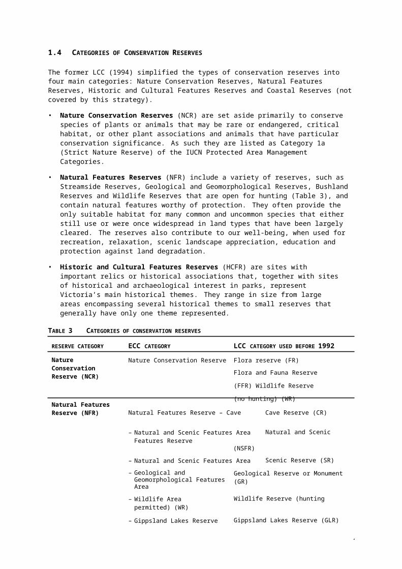
1.4 CATEGORIES OF CONSERVATION RESERVES
The former LCC (1994) simplified the types of conservation reserves into four main categories: Nature Conservation Reserves, Natural Features Reserves, Historic and Cultural Features Reserves and Coastal Reserves (not covered by this strategy).
• Nature Conservation Reserves (NCR) are set aside primarily to conserve species of plants or animals that may be rare or endangered, critical habitat, or other plant associations and animals that have particular conservation significance. As such they are listed as Category 1a (Strict Nature Reserve) of the IUCN Protected Area Management Categories.
• Natural Features Reserves (NFR) include a variety of reserves, such as Streamside Reserves, Geological and Geomorphological Reserves, Bushland Reserves and Wildlife Reserves that are open for hunting (Table 3), and contain natural features worthy of protection. They often provide the only suitable habitat for many common and uncommon species that either still use or were once widespread in land types that have been largely cleared. The reserves also contribute to our well-being, when used for recreation, relaxation, scenic landscape appreciation, education and protection against land degradation.
• Historic and Cultural Features Reserves (HCFR) are sites with important relics or historical associations that, together with sites of historical and archaeological interest in parks, represent Victoria’s main historical themes. They range in size from large areas encompassing several historical themes to small reserves that generally have only one theme represented.
TABLE 3 CATEGORIES OF CONSERVATION RESERVES
RESERVE CATEGORY ECC CATEGORY LCC CATEGORY USED BEFORE 1992
Nature Conservation Reserve (NCR)
Natural Features Reserve (NFR)
Nature Conservation Reserve Flora reserve (FR)
Flora and Fauna Reserve (FFR)
Wildlife Reserve (no hunting) (WR)
Natural Features Reserve – Cave Cave Reserve (CR)
– Natural and Scenic Features Area Natural and Scenic Features Reserve(NSFR)
– Natural and Scenic Features Area Scenic Reserve (SR)
– Geological and Geomorphological Features Area
Geological Reserve or Monument (GR)
– Wildlife Area Wildlife Reserve (hunting permitted) (WR)
– Gippsland Lakes Reserve Gippsland Lakes Reserve (GLR)
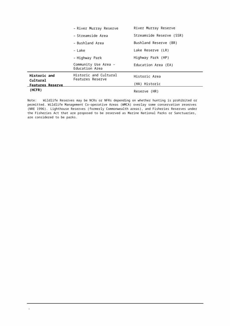
– River Murray Reserve River Murray Reserve
– Streamside Area Streamside Reserve (SSR)
– Bushland Area Bushland Reserve (BR)
– Lake Lake Reserve (LR)
– Highway Park Highway Park (HP)
Historic and Cultural Features Reserve (HCFR)
Community Use Area – Education Area
Historic and Cultural Features Reserve
Education Area (EA)
Historic Area (HA)
Historic Reserve (HR)
Note: Wildlife Reserves may be NCRs or NFRs depending on whether hunting is prohibited or permitted. Wildlife Management Co-operative Areas (WMCA) overlay some conservation reserves (NRE 1996). Lighthouse Reserves (formerly Commonwealth areas), and Fisheries Reserves under the Fisheries Act that are proposed to be reserved as Marine National Parks or Sanctuaries, are considered to be parks.
9
2 MANAGEMENT OBJECTIVES
The management of conservation reserves is directed by a range of legislation, including legislative obligations such as those under the Flora and Fauna Guarantee Act 1988 (Vic.) and the Heritage Act 1995 (Vic.), policies, and Government-accepted recommendations of the former Land Conservation Council and the Environment Conservation Council in relation to the reserve category and individual reserves. NRE (1999) has adopted a set of overarching management objectives for the three reserve categories to clarify desired management goals. Consistent with the LCC/ECC recommendations, the range of permitted and prohibited activities can also be described at the reserves category level. The broad management objectives for the reserves categories, and the permitted activities and uses, are outlined in this section.
Nature Conservation Reserves are to be managed primarily for the conservation of biodiversity. They are suitable for passive recreation such as nature study and picnicking subject to careful management of visitor use. The provision of facilities for visitors and resource use is not usually appropriate.
Natural Features Reserves, including Streamside Reserves, Geological and Geomorphological Reserves, Bushland Reserves and Wildlife Reserves that are open for hunting, are also managed to conserve biodiversity but also for visitor use. They are suitable for passive recreation such as picnicking, walking and where relevant fishing and hunting, and camping. Access is subject to minimal affect on the area, and depends on the character and quality of the local landscape. The provision of visitor facilities is not essential and a range of resource uses is permitted.
Historic and Cultural Features Reserves are managed to protect a range of heritage values and also the conservation of natural values. The larger reserves may ultimately contain visitor recreation facilities such as picnic areas and walking tracks, and high quality interpretation. Others are too small for facilities other than interpretative signs and shelters.
IUCN classification of reserves
The International Union for the Conservation of Nature and Natural Resources provide international standards to facilitate global and regional accounting for protected areas. While IUCN categories have not been assigned to individual reserves (NRE 1996), provisional categories for reserves are proposed depending on the presence or absence of factors such as sustainable use and management intervention required. Factors such as unsustainable use, small size, altered habitat and high hunting pressure result in classification as not part of the protected area network.
Nature Conservation Reserves are provisionally assigned IUCN Category 1a – Protected area managed mainly for science (strict nature reserve). Natural Features Reserves are provisionally assigned IUCN Category IV – Protected area managed mainly for conservation through management intervention (habitat/species management area), III – Protected area managed mainly for conservation of specific natural features (natural monument), or VI (Wildlife Reserves hunting permitted) – Protected area managed mainly for the sustainable use of natural ecosystems (managed resource protection). Historic and Cultural Features Reserves are generally not classified as part of the protected area network.
1
2.1 NATURE CONSERVATION RESERVES
MANAGEMENT OBJECTIVES BASIS
• Conserve and protect species, communities and habitats of indigenous plants, animals and other organisms. (Primary objective)
• Provide for research and study of the natural environment of the reserve where this is consistent with the primary objective and there is minimal impact on the reserve.
• Provide opportunities for appropriate enjoyment and recreation and education by the public where this does not conflict with the primary objective.
DSE management objectives (NRE 1999) derived from Government-accepted LCC recommendations (LCC 1994).
DSE management objectives (NRE 1999) derived from Government-accepted LCC recommendations (LCC 1994).
DSE management objectives (NRE 1999) derived from Government-accepted LCC recommendations (LCC 1994).
• Protect Aboriginal cultural sites and places. Victorian and Commonwealth legislation andGovernment-accepted ECC recommendations (2001).
• Protect historic features in specific reserves where noted.
Victorian legislation and Government-accepted ECC recommendations (2001).
ACTIVITIES AND USES* BASIS
• Permit passive recreation by small numbers of people
• In Box–Ironbark NCRs permit other low-impact recreational activities subject to management requirements, primary objective or as specified:• permit orienteering and rogaining• permit camping (in appropriate locations in
larger reserves)• in some reserves zone to permit dog walking,
subject to land manager• In Box–Ironbark NCRs permit recreational
prospecting and gemstone collection, except in high value areas and where specified by ECC.
• Permit research consistent with primary objective and minimal impact. Note permit under relevant legislation required.
• Do not permit:• grazing• harvesting of forest products• hunting and use of firearms.
• Do not permit apiculture except on traditionally licences sites subject to research and management requirements. In Box–Ironbark NCRs permit apiculture except where specified and subject to research and management requirements.
• In Box–Ironbark NCRs, permit low-impact exploration for minerals, subject to Ministerial approval, and permit mining (subject to government decision).
Government-accepted LCC recommendations (LCC 1994).
Range of permitted activities expanded in the preliminary discussion of ECC recommendations accepted by Government (ECC 2001) for reserves in the Box-Ironbark investigation area.
Government-accepted ECC recommendations (ECC 2001).
Government-accepted LCC recommendations (LCC 1994).
Government-accepted LCC recommendations (LCC 1999) and ECC recommendations (ECC 2001) unless permitted by other recommendations.
Government-accepted LCC recommendations (LCC 1994). Varied for reserves in the Box–Ironbark investigation area by Government-accepted ECC recommendations (ECC 2001).
Government-accepted ECC recommendations (ECC 2001).
* Permitted and prohibited activities subject to LCC/ECC recommendations for individual reserves.
1
2.2 NATURAL FEATURES RESERVES
MANAGEMENT OBJECTIVES* BASIS
• Conserve and protect the natural features and values of the reserve, including any indigenous flora and fauna, maintain scenic features and landscapes, and preserve features of geological and geomorphological interest. (Primary objective)
• Conserve and protect any cultural and historic features and associations.
• Protect historic and Aboriginal cultural values and sites.
• Provide opportunities for appropriate enjoyment, recreation and education by the public, and research and study where this does not conflict with the primary objective.
DSE management objectives (NRE 1999) derived from Government-accepted LCC and ECC recommendations (LCC 1994; ECC 2001).
DSE management objectives (NRE 1999) derived from Government-accepted LCC recommendations (LCC 1994).
Government-accepted ECC recommendations (ECC 2001).
DSE management objectives (NRE 1999) derived from Government-accepted LCC recommendations (LCC 1994).
• For Box–Ironbark reserves protect areas with remnant vegetation or habitat value and maintain character and quality of the local landscape.
Varied for reserves in the Box–Ironbark investigation area by Government-accepted ECC recommendations (ECC 2001).
ACTIVITIES AND USES** BASIS
• Permit passive recreation such as picnicking, walking and, where relevant, fishing.
• Permit more intensive recreation such as camping in individual reserves such as Education Areas where specified by LCC/ECC and for Lakes Reserves subject to manager’s discretion.
• Permit research consistent with primary objective and minimal impact. Note permit under relevant legislation required.
• Limit recreational use of Cave Reserves to small numbers of people.
• Permit hunting in Wildlife Reserves classified as State Game Reserves (subject to legislation).
• Permit grazing in Streamside Reserves, Wildlife Reserves (where it contributes to specified management goals) and recently grazed areas of Bushland Reserves subject to management requirements and manager’s discretion.
• Permit low-intensity post and firewood extraction (not commercial timber harvesting) and gravel extraction in Bushland Reserves subject to manager’s discretion and conditions.
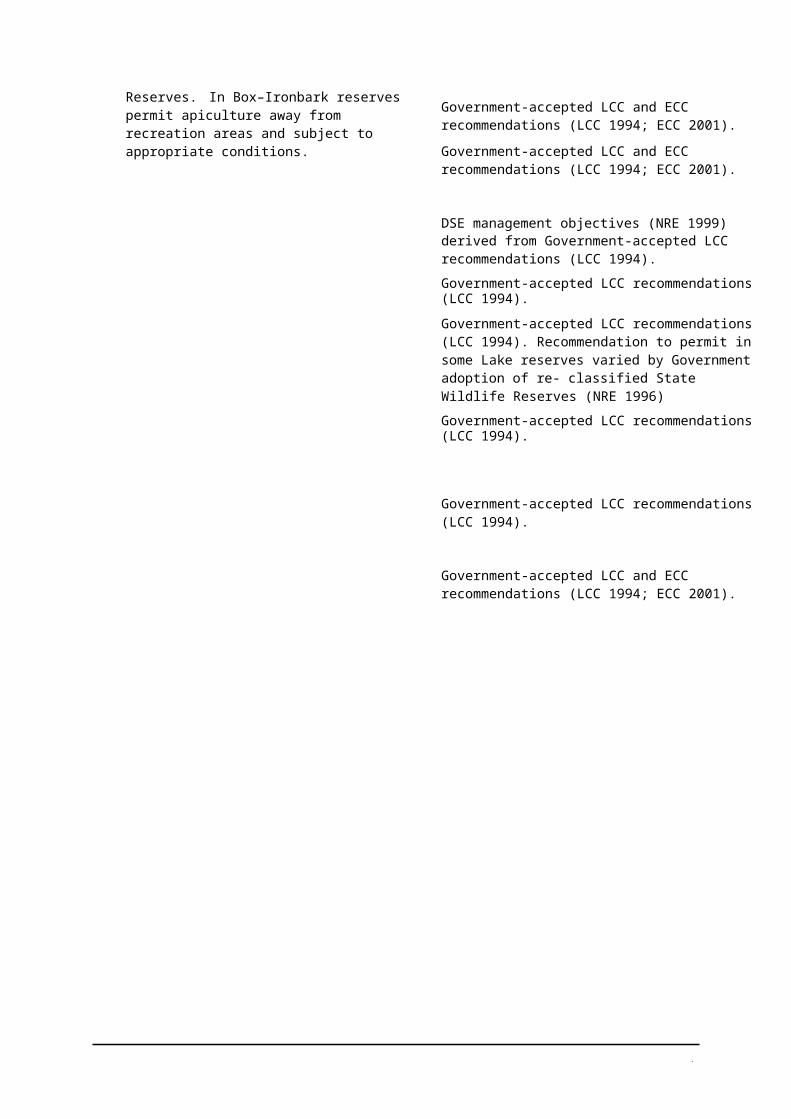
• Permit apiculture on traditionally licensed sites in Bushland Reserves and Natural and Scenic Features Reserves. In Box–Ironbark reserves permit apiculture away from recreation areas and subject to appropriate conditions.
Government-accepted LCC and ECC recommendations (LCC 1994; ECC 2001).
Government-accepted LCC and ECC recommendations (LCC 1994; ECC 2001).
DSE management objectives (NRE 1999) derived from Government-accepted LCC recommendations (LCC 1994).
Government-accepted LCC recommendations (LCC 1994).
Government-accepted LCC recommendations (LCC 1994). Recommendation to permit in some Lake reserves varied by Government adoption of re- classified State Wildlife Reserves (NRE 1996)
Government-accepted LCC recommendations (LCC 1994).
Government-accepted LCC recommendations (LCC 1994).
Government-accepted LCC and ECC recommendations (LCC 1994; ECC 2001).
1
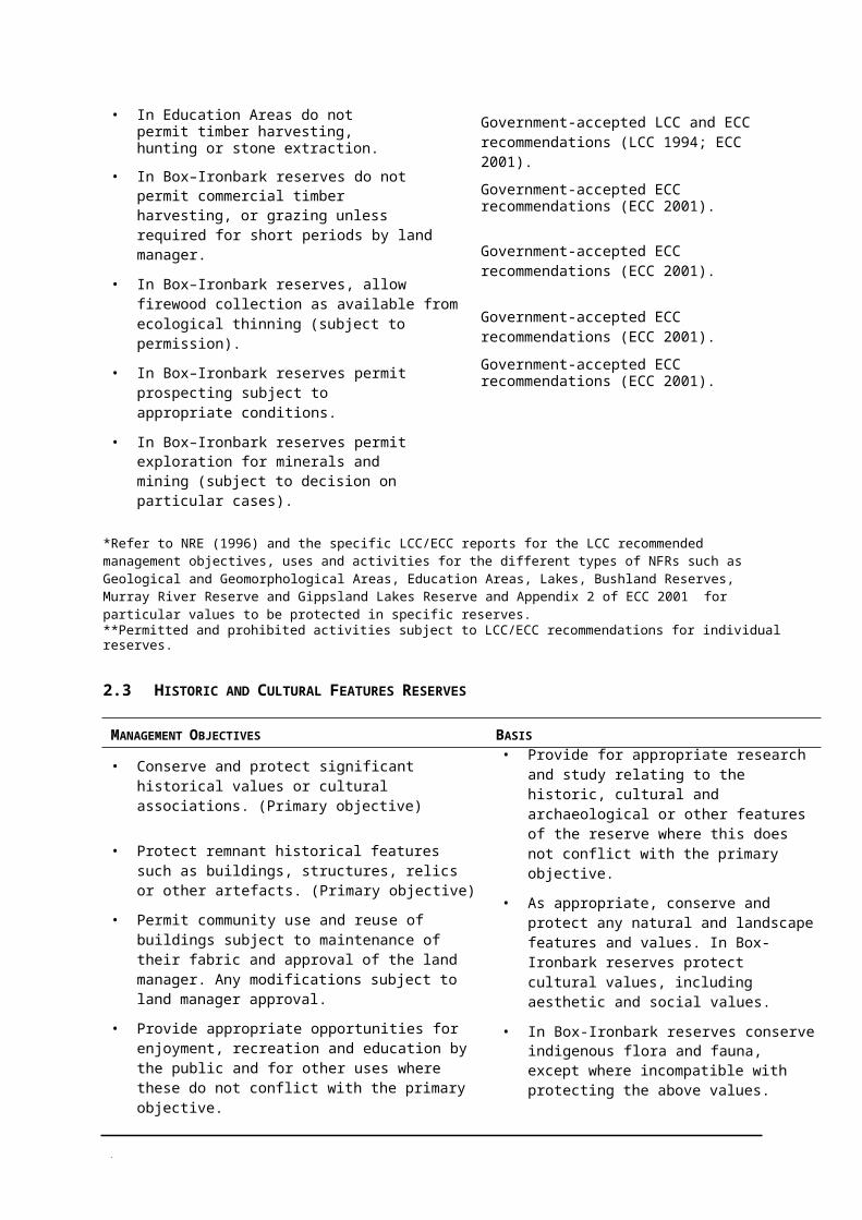
• In Education Areas do not permit timber harvesting, hunting or stone extraction.
• In Box–Ironbark reserves do not permit commercial timber harvesting, or grazing unless required for short periods by land manager.
• In Box–Ironbark reserves, allow firewood collection as available from ecological thinning (subject to permission).
• In Box–Ironbark reserves permit prospecting subject to appropriate conditions.
• In Box–Ironbark reserves permit exploration for minerals and mining (subject to decision on particular cases).
Government-accepted LCC and ECC recommendations (LCC 1994; ECC 2001).
Government-accepted ECC recommendations (ECC 2001).
Government-accepted ECC recommendations (ECC 2001).
Government-accepted ECC recommendations (ECC 2001).
Government-accepted ECC recommendations (ECC 2001).
*Refer to NRE (1996) and the specific LCC/ECC reports for the LCC recommended management objectives, uses and activities for the different types of NFRs such as Geological and Geomorphological Areas, Education Areas, Lakes, Bushland Reserves, Murray River Reserve and Gippsland Lakes Reserve and Appendix 2 of ECC 2001 for particular values to be protected in specific reserves.**Permitted and prohibited activities subject to LCC/ECC recommendations for individual reserves.
2.3 HISTORIC AND CULTURAL FEATURES RESERVES
MANAGEMENT OBJECTIVES BASIS
• Conserve and protect significant historical values or cultural associations. (Primary objective)
• Protect remnant historical features such as buildings, structures, relics or other artefacts. (Primary objective)
• Permit community use and reuse of buildings subject to maintenance of their fabric and approval of the land manager. Any modifications subject to land manager approval.
• Provide appropriate opportunities for enjoyment, recreation and education by the public and for other uses where these do not conflict with the primary objective.
• Provide for appropriate research and study relating to the historic, cultural and archaeological or other features of the reserve where this does not conflict with the primary objective.
• As appropriate, conserve and protect any natural and landscape features and values. In Box-Ironbark reserves protect cultural values, including aesthetic and social values.
• In Box-Ironbark reserves conserve indigenous flora and fauna, except where incompatible with protecting the above values.
DSE management objectives (NRE 1999) derived from Government-accepted LCC recommendations (LCC 1994).
Varied for reserves in the Box–Ironbark investigation area by Government-accepted ECC recommendations (ECC 2001).
Government-accepted LCC and ECC recommendations (LCC; ECC 2001).
DSE management objectives (NRE 1999) derived from Government-accepted LCC recommendations (LCC 1994).
DSE management objectives (NRE 1999) derived from Government-accepted LCC recommendations (LCC 1994).
DSE management objectives (NRE 1999) derived from Government-accepted LCC recommendations (LCC 1994) and as varied by ECC recommendations (ECC 2001).
Varied for reserves in the Box–Ironbark investigation area by Government-accepted ECC recommendations (ECC 2001).
1
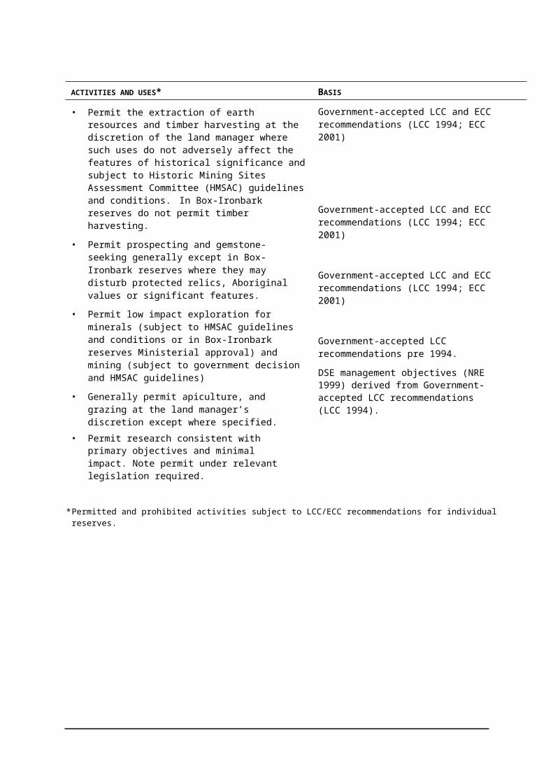
ACTIVITIES AND USES* BASIS
• Permit the extraction of earth resources and timber harvesting at the discretion of the land manager where such uses do not adversely affect the features of historical significance and subject to Historic Mining Sites Assessment Committee (HMSAC) guidelines and conditions. In Box-Ironbark reserves do not permit timber harvesting.
• Permit prospecting and gemstone-seeking generally except in Box-Ironbark reserves where they may disturb protected relics, Aboriginal values or significant features.
• Permit low impact exploration for minerals (subject to HMSAC guidelines and conditions or in Box-Ironbark reserves Ministerial approval) and mining (subject to government decision and HMSAC guidelines)
• Generally permit apiculture, and grazing at the land manager’s discretion except where specified.
• Permit research consistent with primary objectives and minimal impact. Note permit under relevant legislation required.
Government-accepted LCC and ECC recommendations (LCC 1994; ECC 2001)
Government-accepted LCC and ECC recommendations (LCC 1994; ECC 2001)
Government-accepted LCC and ECC recommendations (LCC 1994; ECC 2001)
Government-accepted LCC recommendations pre 1994.
DSE management objectives (NRE 1999) derived from Government-accepted LCC recommendations (LCC 1994).
* Permitted and prohibited activities subject to LCC/ECC recommendations for individual reserves.
1
3 OVERVIEW OF THE RESERVE ESTATE
This section presents an overview of the current knowledge about Conservation Reserves in Parks Victoria regions and districts (see Map 1), including:
• the number, area and types of reserves;
• a comparison of the range of natural and cultural values in the three reserve categories;
• a summary of visitor numbers and facilities provided;
• an assessment of the management activity; and
• information gaps and data limitations.
3.1 OVERVIEW OF THE RESERVE ESTATE
Parks Victoria manages a total of 27851 Conservation Reserves, including 24 Coastal Reserves, according to the Parks and Reserves Register. Spatial records exist for 26711 Conservation Reserves, which cover an area of 467 445 ha (Table 4). Most of these reserves (81%) and over half the area (52%) are Natural Features Reserves. Nature Conservation Reserves account for 15% of the total number and almost 40% of the total area, while Historical and Cultural Features Reservesconstitute only 4% and 9% of the number and area of Conservation Reserves, respectively.
TABLE 4 NUMBER AND AREA OF EACH CONSERVATION RESERVE CATEGORY
RESERVE CATEGORY NO. OF RESERVES AREA OF RESERVES (HA)
NCR 387 182 606
NFR 2174 244 436
HCFR 110 40 403
Total 2671 467 445
3.1.1 Number of reserves
Most Conservation Reserves are Bushland Reserves, and there are almost twice the number of Flora Reserves compared with other categories of Nature Conservation Reserve (Table 5).
Nature Conservation Reserves, Natural Features Reserves and Historical and Cultural Features Reserves are found in all Parks Victoria regions (Table 6 and Map 1). The highest number of Conservation Reserves is in West region; Conservation Reserves within this region comprise 45% of the total number of Conservation Reserves in the state. West region also has the highest number of Nature Conservation Reserves and Natural Features Reserves, while Central region has the highest number of Historical and Cultural Features Reserves. In contrast, City and Bays, and Melbourne Metropolitan regions have the least number of reserves (< 5%) of the total in the state.
1 Source of data: Unless otherwise indicated, the data presented in this report were compiled using spatial records from the PV Park_Bound GIS layer. Differences between this dataset and the Parks and Reserves Register (which duplicates DSE’s PRIMS) are 90 reserves mostly (74) non-spatial Conservation Reserves. These will be resolved with future updates to the databases and systems.
1
TABLE 5 NUMBER OF RESERVES WITHIN EACH LCC/ECC CATEGORY
RESERVE CATEGORY LCC/ECC CATEGORY NO. OF RESERVES
NCR Nature Conservation Reserve 49
Flora and Fauna Reserve 92
Flora Reserve 170
Wildlife Reserve (NCR classification pending reservation) 13
Wildlife Reserve (no hunting) 63
NFR Natural Features Reserve 38
Cave Reserve 7
Scenic Reserve 59
Natural Features and Scenic Reserve 26
Geological Reserve 11
Wildlife Reserve (hunting) 169
Wildlife Reserve (SGR classification pending reservation) 39
Gippsland Lakes Reserve 5
River Murray Reserve 1
Streamside Reserve 260
Bushland Reserve 1 391
Lake Reserve 111
Highway Park 12
Community Use Area – Education Area 45
HCFR Historic Area or Reserve 110
Conservation Reserves occur in all Parks Victoria districts, except City & Waterways (Table 6; Map 1). All Conservation Reserve categories are found in each of the remaining districts, except Historical and Cultural Features Reserves, which do not occur in the Dandenongs and East Metropolitan districts. Three districts in two regions, West and Central, have more than half of all Conservation Reserves in Victoria: Grampians, Murray Central and Mallee. In contrast, the six districts within City and Bays and Melbourne Metropolitan regions each have less than 2% of the total number of Conservation Reserves in the state.
1
TABLE 6 NUMBER AND AREA OF RESERVES OF EACH CATEGORY IN EACH REGION AND DISTRICT
PARKS VICTORIA REGION/DISTRICT
NCR NFR HCFR REGION/DISTRICT TOTAL
NO. AREA (HA) NO. AREA (HA) NO. AREA (HA) NO. AREA (HA)
Central 110 33 119 729 40 296 46 10 137 885 83 552
Basalt Plains 17 2 837 72 1 306 1 0.05 90 4 143
Central Highlands 24 6 741 124 5 921 6 838 154 13 500
Murray Central 69 23 541 533 33 069 39 9 299 641 65 909
City & Bays 18 3 089 32 4 080 3 142 53 7 311
City & Waterways 0 0 0 0 0 0 0 0
Mornington/ Westernport
10 1 958 25 225 2 141 37 2 324
Port Phillip 8 1 131 7 3 855 1 0.7 16 4 987
East 70 20 913 279 54 857 22 27 143 371 102 913
Alpine 8 581 78 18 602 12 23 330 98 42 513
East Gippsland 24 10 589 65 22 897 3 120 92 33 606
West Gippsland 38 9 743 136 13 358 7 3 693 181 26 794
Melbourne Metropolitan
14 1 716 75 1 219 1 0.09 90 2 935
Dandenongs 2 322 34 731 0 0 36 1 053
East Metropolitan 3 131 19 206 0 0 22 337
Yarra 9 1 263 22 282 1 0.09 32 1 545
West 175 123 769 1 059 143 984 38 2 981 1 272 27 0734
Grampians 71 24 031 608 60 344 33 2 326 712 86 701
Mallee 60 85 819 307 56 825 2 652 369 143 296
West Coast 44 13 919 144 26 815 3 3 191 40 737
Total 387 182 606 2 174 244 436 110 40 403 2 671 467 445

% e
ach
Con
serv
atio
n R
eser
ve
1
Figure 2 shows within each district, the number of reserves in each category as a percentage of the total number of reserves in that category. Murray Central and Grampians districts, have the highest representation of each of the three Conservation Reserve categories. Of districts that contain reserves, Dandenongs has the least representation of Nature Conservation Reserves (0.5%), Port Phillip has the least representation of Natural Features Reserves (0.3%), while Yarra, Port Phillip and Basalt Plains have the least representation of Historical and Cultural Features Reserves (0.9%).
FIGURE 2 THE PERCENTAGE OF RESERVES OF EACH CATEGORY BY DISTRICT
40NCRNFR
35HCFR
30
25
20
15
10
5
0
District
In almost all districts that have Conservation Reserves, the highest percentage of reserves are Natural Features Reserves, with the Dandenongs district having the highest percentage within any district (94%). The only exception is Port Phillip district, where only 44% of reserves are Natural Features Reserves and 50% of reserves are Nature Conservation Reserves, which is the highest percentage of this reserve category. Alpine district has the highest proportion of Historical and Cultural Features Reserves (12%).
3.1.2 Area of reserves
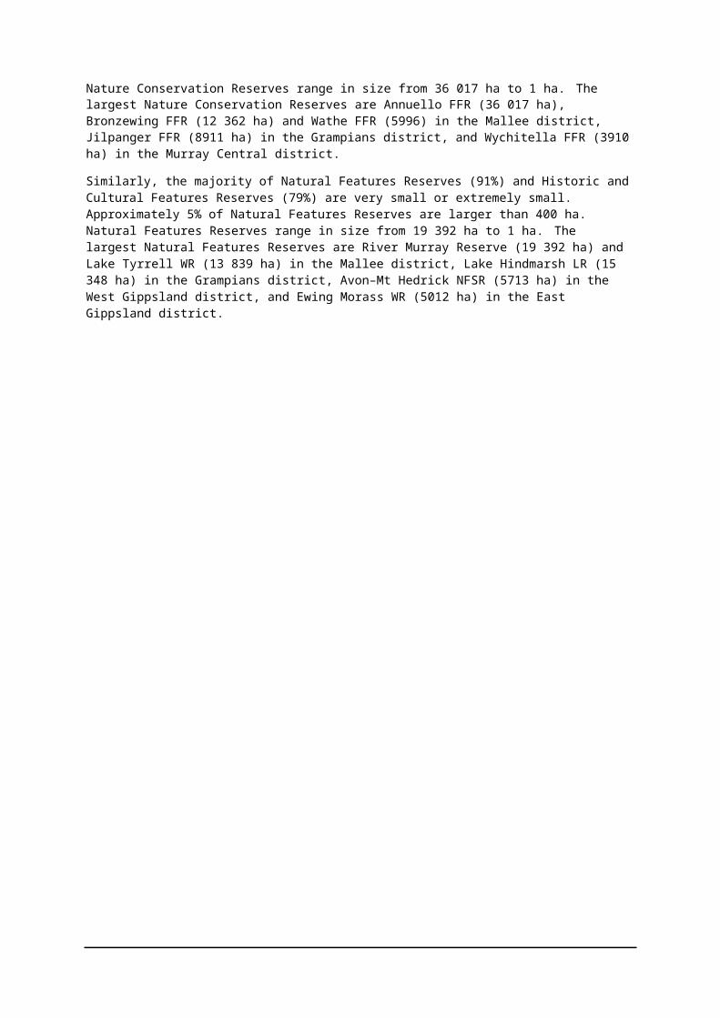
The majority of Conservation Reserves (93%) are smaller than 400 ha (Figure 3).
The majority of Nature Conservation Reserves (39%) are also small (200–400 ha), 16% are very small (10–200 ha) and 5% are extremely small (<10 ha). Nature Conservation Reserves range in size from 36 017 ha to 1 ha. The largest Nature Conservation Reserves are Annuello FFR (36 017 ha), Bronzewing FFR (12 362 ha) and Wathe FFR (5996) in the Mallee district, Jilpanger FFR (8911 ha) in the Grampians district, and Wychitella FFR (3910 ha) in the Murray Central district.
Similarly, the majority of Natural Features Reserves (91%) and Historic and Cultural Features Reserves (79%) are very small or extremely small. Approximately 5% of Natural Features Reserves are larger than 400 ha. Natural Features Reserves range in size from 19 392 ha to 1 ha. The largest Natural Features Reserves are River Murray Reserve (19 392 ha) and Lake Tyrrell WR (13 839 ha) in the Mallee district, Lake Hindmarsh LR (15 348 ha) in the Grampians district, Avon–Mt Hedrick NFSR (5713 ha) in the West Gippsland district, and Ewing Morass WR (5012 ha) in the East Gippsland district.
No.
of C
onse
rvat
ion
1
Historic and Cultural Features Reserves range in size from 8779 ha to 1 ha. Only 17 HCFRs are larger than 400 ha. Among the largest are Mount Wills HA (8779 ha), Grant HA (7437 ha) and Cassilis HA (4353 ha) all in the Alpine district, Castlemaine–Chewton HA (3609 ha) in the Murray Central district, and Walhalla HA (2635 ha) in the West Gippsland district.
FIGURE 3 NUMBER OF CONSERVATION RESERVES BY SIZE CLASS
1400
1200
NCR NFR HCFR
1000
800
600
400
200
0extremely small (< 10) very small (10 - 200) small (200 - 400) large (>400)
Size (ha)
The largest area of Conservation Reserves is in the West region; Conservation Reserves within this region comprise 58% (270 734 ha) of the total area of Conservation Reserves in the state (Table 6, Map 2). West region also has the greatest area of Nature Conservation Reserves (26% of the total area) and Natural Features Reserves (31% of the total area), while East region has the greatest area of Historical and Cultural Features Reserves (6% of the total area). In contrast, Melbourne Metropolitan region has the smallest area of Conservation Reserves (< 1% of the total area) and the smallest area of each reserve category.
Parks Victoria districts with the largest area of Conservation Reserves are Mallee (31% of the total area), Grampians (18%) and Murray Central (14%). In contrast, the six districts within the City and Bays and Melbourne Metropolitan regions have < 3% of the total area of Conservation Reserves in the state.
Figure 4 shows, for each district, the area of each reserve category as a percentage of the total area of that category in the state. The largest representation by area of reserve categories is Historical and Cultural Features Reserves in the Alpine district: 58% of the total area of this category is found in this district, while 23% of the area of Historical and Cultural Features Reserves occurs in Murray Central. Almost 50% of the total area of Nature Conservation Reserves occurs in the Mallee, while 13% occurs within both the Grampians and Murray Central districts. The largest areas of Natural Features Reserves are in the Grampians and Mallee districts: 28% and 25% of the total area of this category occurs in these two districts, respectively.
% a
rea
of re
serv
e
1
FIGURE 4 PERCENTAGE AREA OF EACH CONSERVATION RESERVE CATEGORY BY DISTRICT
70 NCRNFR
60 HCFR
50
40
30
20
10
0
District
In over 50% of districts, Natural Features Reserves contribute the greatest percentage of area within each district, with Port Phillip having the highest percentage area of Natural Features Reserves (77%). Five districts, however, have a greater representation by area of Nature Conservation Reserves than Natural Feature Reserves. The Mornington/Westernport and Yarra districts contain the greatest percentage area of Nature Conservation Reserves (84% and 81% of area, respectively). The Alpine district has the largest percentage area of Historical and Cultural Features Reserves, which constitute 54% of the total area of reserves within this district.
3.1.2 Connectivity
In the absence of a detailed survey/analysis of the amount of indigenous vegetation surrounding reserves, the size of the surrounding vegetation and the distance to the nearest vegetation, the following analysis of the percentage of the reserve boundary bordered by adjacent vegetation1 is presented as a broad indication of the extent of fragmentation of reserves across the landscape.
EVCs consist of one or a number of floristic communities that exist under a common regime of ecological processes within a particular environment. They are modelled to represent the most detailed level of vegetation typology available. EVC mapping is yet to be completed in the north-west of the state for 24% (645) of the Conservation Reserves. The limitations of using EVC data are outlined in section 3.3.
At the EVC level, some 19% of all Conservation Reserves have no adjacent indigenous vegetation. A further 22% (581) of all Conservation Reserves have less than 10% of their boundary with adjacent indigenous vegetation. More than half (54%) of all Conservation Reserves have less than 30% of their boundary with adjacent indigenous vegetation (Table 7).
1 Source of data: Ecological Vegetation Classes EVC layer, DSE corporate geospatial dataset
1
Only 39% of Nature Conservation Reserves are well buffered by adjacent indigenous vegetation; that is have more that 60% of their boundary with adjacent indigenous vegetation, and the majority have less than 30% of their boundary with indigenous vegetation. Only 13% of Natural Features Reserves and 13% Historic and Cultural Features Reserves are well buffered by adjacent indigenous vegetation.
TABLE 7 NUMBER OF CONSERVATION RESERVES BY SIZE AND CONNECTIVITY CLASS
RESERVE % BOUNDARY BORDERED BY INDIGENOUS VEGETATION (EVC)SIZE (HA)
0-<30% >30%-< 60% > 60% - < 100% 100%
NCR NFR HCFR NCR NFR HCFR NCR NFR HCFR NCR NFR HCFR
0 – 10 26 438 39 3 147 6 9 92 4 5 70 2
>10–200 107 525 21 25 120 5 16 68 2 13 33 3
>200–400 25 52 3 4 7 1 5 5 2 1 3 0
>400 41 69 15 4 4 0 2 4 0 1 4 1
3.1.3 Intrinsic viability
In the absence of a statewide survey of the condition of vegetation communities and flora and fauna populations, the size of reserves combined with connectivity of reserves to indigenous vegetation is used as a broad indication of intrinsic ecological viability of reserves i.e. the likelihood that a reserve will be able to maintain the long-term survival of ecosystems and species without management intervention (PV 2000b).
Table 7 compares the number of Conservation Reserves grouped by size and the proportion of the boundary with surrounding indigenous vegetation (EVC) categories. The majority of reserves have lower intrinsic viability. More than 43% of Conservation Reserves are both very small (<200 ha) and have less than 30% of their boundaries with surrounding indigenous vegetation. These reserves comprise 34% of Nature Conservation Reserves, 44% of Natural Features Reserves and 55% of Historical and Cultural Features Reserves. Over 55% of Conservation Reserves are both very small (<200 ha) and isolated from indigenous vegetation (have less than 60% of their boundaries with surrounding indigenous vegetation). These reserves comprise 42% of Nature Conservation Reserves, 57% of Natural Features Reserves and 65% of Historical and Cultural Features Reserves. Less than 1% are larger than 400 ha and surrounded by or well buffered by adjacent indigenous vegetation (comprising 1% of Historical and Cultural Features Reserves and less than 0.5% of Nature Conservation Reserves and Natural Features Reserves).
3.1.4 Natural values
Vegetation communities
Detailed information about floristic communities in Conservation Reserves in Victoria is not available.In an effort to gain a broad understanding of the differing importance of vegetation communities in reserves the following aspects of the Ecological Vegetation Classes1 (EVC) data sets were analysed. Because vegetation is highly fragmented across much of Victoria, reserves with areas of the followingvegetation communities are considered important in protecting biodiversity as well as contributing to a representative, comprehensive and adequate parks and reserves system:
• a community with less then 30% of their pre-European extent remaining in the bioregion (threatened EVC);
• an area of a community that is larger than the total area protected in parks in the bioregion or a community that occurs in less than five parks or reserves (important EVC);
1 Source of data: Ecological Vegetation Classes EVC layer, DSE corporate geospatial dataset.
2
• a community that is inadequately reserved in the protected area network, that is less than 15% in parks or reserves (rare EVC); and
• a large area of a community that is greater than 5% of the total bioregion (large EVC).
Threatened EVCs
DSE has classified the conservation status of all EVCs at a bioregional level. Threatened EVCs are categorised as Presumed Extinct (no longer present in the bioregion – the accuracy of the presumption being limited by the use of remotely sensed 1:100 000 scale vegetation mapping), Endangered (<10% remaining of pre-European extent remains) and Vulnerable (10 to 30% of pre- European extent remains) (NRE 2002).
Almost half of reserves (1 318) have threatened EVCs, and a quarter have between two and thirteen different threatened EVCs. Nature Conservation Reserves have 239 reserves (62% of NCRs) with threatened EVCs, 1% have Presumed Extinct EVCs, 43% have Endangered EVCs, and 32% have Vulnerable EVCs (Table 8). Natural Features Reserves have 1035 reserves (48% of NFRs) with threatened EVCs, <1% have Presumed Extinct EVCs, 36% have Endangered EVCs and 22% have Vulnerable EVCs. Historical and Cultural Features Reserves have 44 reserves (40% of HCFRs) with threatened EVCs, 32% have Endangered EVCs, and 17% have Vulnerable EVCs.
TABLE 8 NUMBER OF THREATENED EVCS IN CONSERVATION RESERVES
RESERVE
TYPE PRESUMED EXTINCT
EVC CONSERVATION STATUS
ENDANGERED VULNERABLE TOTAL
NCR 4 165 144 313
NFR 8 774 477 1259
HCFR 0 35 19 54
Murray Central and Grampians Districts have the highest number of reserves with threatened EVCs (354 in Murray Central and 397 in Grampians), whereas City and Waterways, Dandenongs and East Metropolitan Districts combined have only 15 reserves with threatened EVCs.
Important, rare and large EVCs
Important EVCs are defined as an area of an EVC that is larger that the total area in parks in the bioregion. Figure 5 shows that 879 Conservation Reserves (33% of reserves) have important EVCs. There are 168 Nature Conservation Reserves (43% of NCRs) with important EVCs, 687 Natural Features Reserves (32% of NFRs) with important EVCs and 24 Historic and Cultural Features Reserves (22% of HCFRs) with important EVCs.
More than 75% of these reserves are in three districts: Murray Central has 300 reserves with important EVCs, Grampians has 250 and West Coast has 113. All other districts combined have only 216 reserves with important EVCs.
Rare EVCs are defined as EVCs found in less that 5 other parks or reserves, or EVCs where <15% of the total area in the bioregion is protected in parks and reserves. Figure 5 shows that a total of 252 Conservation Reserves (9% of reserves) have rare EVCs. There are 52 Nature Conservation Reserves (13% of NCRs) with rare EVCs, 190 Natural Features Reserves (9% of NFRs) with rare EVCs and 10 Historic and Cultural Features Reserves (9% of HCFRs) with rare EVCs.
Murray Central, Grampians and West Coast districts also have the highest number of reserves with rare EVCs totalling more than 73% of all rare EVCs (51 in Murray Central, 99 in Grampians and 34 in West Coast). All other districts combined contain only 68 reserves with rare EVCs.
No
Con
serv
atio
n
2
FIGURE 5 NUMBER OF IMPORTANT, RARE AND LARGE EVCS IN CONSERVATION RESERVES
1000
900
800
700
NCR NFR HCFR
600
500
400
300
200
100
0Important EVC Rare EVC Large EVC
Large EVCs are defined as those with an area greater than 5% of the bioregion. A total of 246 Conservation Reserves (just over 9% of reserves) have large EVCs. There are 78 Nature Conservation Reserves (20% of NCRs) with large EVCs, 160 Natural Features Reserves (7% of NFRs) with large EVCs and 8 Historic and Cultural Features Reserves (7% of HCFR) with large EVCs
Fauna diversity
In the absence of comprehensive fauna surveys for reserves, analysis of the data from DSE's statewide Atlas of Victoria Wildlife database is used to give an indication of the faunal diversity in reserves. The limitations of the dataset are outlined in Section 3.3.
Most reserves have few or no records of fauna species (Figure 6). This probably indicates that the majority of reserves have yet to be surveyed and existing records are opportunistic sightings.
Existing statewide records, as listed in the Atlas of Victorian Wildlife, indicate that 31% of the 2671 Conservation Reserves have fauna records. Recorded fauna diversity within individual reserves range from 280 species to just one species. Most reserves have few recorded fauna species (Figure 6), which, in most cases, probably reflects that records are opportunistic sightings and that a reserve has not yet been surveyed, rather than a low fauna diversity.
Individual reserves with the highest numbers of fauna species include River Murray Reserve (NFR), which has 280 fauna species, and Coranderrk NCR, which has 208 fauna species. Castlemaine– Chewton HA has the highest number of species records for Historical and Cultural Features Reserves (164 species).
2
No.
of C
onse
rvat
ion
1 1
FIGURE 6 NUMBER OF CONSERVATION RESERVES BY RECORDED FAUNA DIVERSITY CLASS
800
700
188
NCR NFR HCFR
600
500
400
300 538
200
10038 1040 5
0 30 6 1
1 - 69 species 70 - 137 species 138 - 205 species 206 - 273 species 274 - 339 species
No. of fauna species
Most of the reserves with fauna records are Natural Features Reserves, while just under one third are Nature Conservation Reserves and less than 5% are Historical and Cultural Features Reserves (Table 9). Although more Natural Features Reserves have fauna records, both Nature Conservation Reserves and Historical and Cultural Features Reserves have a higher percentage of reserves with fauna records; 61% and 34% respectively, while 27% of Natural Features Reserves have fauna records.
TABLE 9 NUMBER AND PERCENTAGE OF CONSERVATION RESERVES IN EACH CATEGORY WITH FAUNA RECORDS
RESERVE CATEGORY NO. RESERVES WITH FAUNA RECORDS) RESERVES WITH RECORDS AS A% OF ALL RESERVES
NCR 237 9
NFR 584 21
HCFR 37 1
Total 858 31
Threatened fauna
Of the 254 threatened fauna species protected within the entire parks and reserves system, at least 70% (179 species, comprising 2571 records) are found in Conservation Reserves. Current records for threatened fauna within individual reserves ranges from 1 to 53 species of threatened fauna (Figure 7).
No.
of C
onse
rvat
ion
2
FIGURE 7 NUMBER OF CONSERVATION RESERVES BY THREATENED FAUNA CLASS
500
450
400
350121
NCR NFR HCFR
300
250
200
150 291
100
50 30 1354 19 6 2
19 3 2 1 10
1 - 6 species 7 - 12 species 13 - 19 species 20 - 25 species 26 - 68 species
No. of threatened fauna species
Threatened fauna species have been recorded from 562 Conservation Reserves (21% of reserves). Natural Features Reserves have more than twice as many reserves with threatened fauna records than Nature Conservation Reserves and over 15 times as many reserves with threatened fauna records than Historical and Cultural Reserves (Table 10).
However, Nature Conservation Reserves have a higher percentage of reserves with threatened fauna (43% of reserves) than both Historical and Cultural Reserves (22% of reserves) and Natural Features Reserves (17% of reserves).
TABLE 10 NUMBER AND PERCENTAGE OF CONSERVATION RESERVES IN EACH CATEGORY WITH THREATENED FAUNA RECORDS
RESERVE CATEGORY NO. RESERVES WITH THREATENED FAUNA
RECORDS
% OF ALL RESERVES
NCR 166 6
NFR 372 14
HCFR 24 1
Total 562 20
Highest Priority threatened fauna species have been determined by DSE as those species considered to be of highest priority for conservation management in Victorian bioregions (NRE 1999). Only 118 reserves have records of highest priority fauna species, these reserves are in all districts, except City& Waterways (Table 11). Murray Central district has the highest number of reserves with Highest Priority fauna, and the highest number of records, while Mallee district has the greatest number of Highest Priority fauna species.
2
TABLE 11 NUMBER OF HIGHEST PRIORITY FAUNA RECORDS AND NUMBER OF RESERVES WITH HIGHEST PRIORITY FAUNA SPECIES FOR EACH DISTRICT
DISTRICT RESERVES WITH HIGHEST PRIORITY FAUNA
NO. OF HIGHEST PRIORITY FAUNA SPECIES
NO. OF RECORDS WITH HIGHESTPRIORITY FAUNA
Basalt Plains 1 2 2
Central Highlands 5 4 9
Murray Central 38 8 52
City & Waterways 0 0 0
Mornington/Westernport 2 4 5
Port Phillip 6 3 9
Alpine 1 2 2
East Gippsland 9 9 13
West Gippsland 5 4 10
Dandenongs 3 1 3
East Metropolitan 1 1 1
Yarra 3 1 3
Grampians 10 7 11
Mallee 17 12 20
West Coast 17 6 23
Flora diversity
In the absence of comprehensive flora surveys for reserves, analysis of the data from DSE's statewide Flora Information System database is used to give an indication of the flora diversity in reserves. The limitations of the dataset are outlined in Section 3.3.
Most reserves have low numbers or no records of flora species (Figure 8). This probably indicates that the majority of reserves have yet to be surveyed and existing records are opportunistic sightings.
Existing statewide records, as listed in the Flora Information System, indicate that 27% of the 2671 Conservation Reserves have flora records (Table 12). Flora diversity within individual reserves ranges from 1 to 508 species. As for fauna diversity, most reserves have low numbers of flora species (Figure 8), which in most cases, probably reflects low survey effort within a reserve, rather than low flora diversity.
Individual reserves with the highest number of flora species are the Jilpanger FFR (NCR) and Coranderrk NCR, which both have approximately 500 species of flora. With over 400 species of flora, Maldon HA and Ewing Morass WR have the most flora species within Historical and Cultural Features Reserves and Natural Features Reserves, respectively.
224
459
226
29 32
No.
of C
onse
rvat
ion
2
FIGURE 8 NUMBER OF CONSERVATION RESERVES BY FLORA DIVERSITY CLASS
800
700
NCR NFR HCFR
600
500
400
300
200
100
01 - 240 species 241 - 480 species 481 - 720 species
No. of flora species
Most of the reserves with flora records are Natural Features Reserves, while one third are Nature Conservation Reserves and less than 5% are Historical and Cultural Features Reserves (Table 12). Although more Natural Features Reserves have flora records, both Nature Conservation Reserves and Historical and Cultural Features Reserves have a higher percentage of reserves with flora records; 64% and 29%, respectively, while 17% of Natural Features Reserves have flora records.
TABLE 12 NUMBER AND PERCENTAGE OF CONSERVATION RESERVES IN EACH CATEGORY WITH FLORA RECORDS
RESERVE CATEGORY NO. RESERVES WITH FLORA RECORDS % OF ALL RESERVES
NCR 248 9
NFR 465 17
HCFR 32 1
Total 745 27
No.
of C
onse
rvat
ion
2
Threatened flora
Of the 1465 threatened flora species recorded within the entire parks and reserves system 45% (664 species, comprising 1668 records) are found in the Conservation Reserves. Current records for threatened flora within individual reserves range from 1 to 61 species (Figure 9).
FIGURE 9 NUMBER OF CONSERVATION RESERVES BY THREATENED FLORA CLASS
400
350NCR NFR HCFR
300 139
250
200
150
100215
50 332
14 240
2 1 46 3 3
1-6 species 7-12 species 13-19 species 20-25 species 26-68 species
No. of threatened flora species
Threatened species have been recorded from 447 Conservation Reserves (17% of reserves). Natural Features Reserves have more reserves with threatened flora records than Nature Conservation Reserves, while both of these reserve categories have over ten times as many reserves with threatened flora records than Historical and Cultural Reserves (Table 13).
However, Nature Conservation Reserves have a higher percentage of reserves with threatened flora (48% of reserves) than both Historical and Cultural Reserves (15% of reserves) and Natural Features Reserves (11% of reserves).
TABLE 13 NUMBER AND PERCENTAGE OF CONSERVATION RESERVES IN EACH CATEGORY WITH THREATENED FLORA RECORDS
RESERVE CATEGORY NO. RESERVES WITH THREATENED FLORA
RECORDS
% OF ALL RESERVES
NCR 184 7
NFR 246 9
HCFR 17 1
Total 447 16
Highest Priority flora species have been determined by DSE as those species considered to be of highest priority for conservation management in Victorian Bioregions (NRE 1999). Only 70 reserves have records of Highest Priority flora, these reserves in eight districts (Table 14). Mallee district has the highest number of reserves with Highest Priority flora, the highest number of records, and the greatest number of Highest Priority flora species.
2
TABLE 14 NUMBER OF HIGHEST PRIORITY FLORA RECORDS AND NUMBER OF RESERVES WITH HIGHEST PRIORITY FLORA SPECIES FOR EACH DISTRICT
DISTRICT RESERVES WITH HIGHEST PRIORITY FLORA
NO. OF HIGHEST PRIORITY FLORA
NO. RECORDS OF HIGHEST PRIORITY
SPECIES FLORA
Basalt Plains 1 1 1
Central Highlands 0 0 0
Murray Central 16 12 18
City & Waterways 0 0 0
Mornington/Westernport 0 0 0
Port Phillip 0 0 0
Alpine 2 2 2
East Gippsland 12 11 15
West Gippsland 3 3 3
Dandenongs 0 0 0
East Metropolitan 0 0 0
Yarra 0 0 0
Grampians 12 12 16
Mallee 22 28 47
West Coast 2 2 2
Combined threatened fauna and flora species
Threatened species of flora and/or fauna1 have been recorded from 766 Conservation Reserves (28% of all reserves). Species records for individual reserves vary considerably. Approximately 70% of Conservation Reserves have no species recorded in the DSE statewide databases (see the Fauna and Flora Diversity sections above). Of reserves with species records, a number have many records probably from comprehensive fauna and vegetation surveys, a number have only fauna or flora records probably from specific surveys or research projects, many have incomplete records derived from opportunistic sightings or records from scientists, Field Naturalists and other interested individuals and groups. For these reasons the number of reserves with either or both flora and fauna records is greater than the number with just both.
Natural Features Reserves have nearly twice as many reserves with threatened flora and/or fauna records than Nature Conservation Reserves, and over 18 times as many reserves with threatened flora and/or fauna records than Historical and Cultural Features Reserves (Table15).
TABLE 15 NUMBER AND PERCENTAGE OF CONSERVATION RESERVES IN EACH CATEGORY WITH THREATENED FLORA AND FAUNA RECORDS
RESERVE CATEGORY NO. RESERVES WITH THREATENED FLORA
AND/OR FAUNA RECORDS
% OF ALL RESERVES
NCR 252 9
NFR 487 18
HCFR 27 1
Total 766 28
1 Source of data: DSE Atlas of Victorian Wildlife and Flora Information System

No.
of
2
However, Nature Conservation Reserves have a higher percentage of reserves of that category with threatened flora and/or fauna (65% of reserves) than both Historical and Cultural Features Reserves (25% of reserves) and/or Natural Features Reserves (22% of reserves).
Wetlands
Figure 10 shows that the majority of reserves, 76%, have no wetland, 1% have wetlands that are included in Ramsar sites (wetlands of international importance listed under the Ramsar convention), 6% have important wetlands and 17% have other wetlands1. Nearly a third of Conservation Reserveswith wetlands have important wetlands and 19% of these (36 reserves) have wetlands in Ramsar. In Nature Conservation Reserves 27% of wetlands are considered important, of these 8% are Ramsar wetlands. In Natural Features Reserves 23% of wetlands are considered important, of these 5% are Ramsar wetlands. In Historic and Cultural Features Reserves 31% of wetlands are considered important, of these 6% are Ramsar wetlands.
FIGURE 10 NUMBER OF CONSERVATION RESERVES WITH WETLANDS IN EACH CATEGORY
2500
2000
NCR NFR
HCFR
1500
1000
500
0Important and Ramsar W etlands Other W etlands No W etlands
Type of wetland
Approximately one quarter of all Conservation Reserves (a total of 650 reserves) contain one or more wetland (Table 16). Most reserves with wetlands are Natural Features Reserves (87%), less than 10% are Natural Features Reserves and less than 3% are Historic and Cultural Features Reserves. A third of Nature Conservation Reserve contain one or more wetland, 23% of Natural Features Reserves contain one or more wetland, and 15% of Historic and Cultural Features Reserves contain one or more wetland.
TABLE 16 NUMBER OF CONSERVATION RESERVES IN EACH CATEGORY WITH WETLANDS
RESERVE CATEGORY
NO. RESERVES WITH RAMSAR
NO. RESERVES WITH IMPORTANT
NO. RESERVES WITH OTHER
TOTAL NO. RESERVES WITH
WETLANDS WETLANDS WETLANDS WETLANDS
NCR 10 35 83 128
NFR 25 115 366 506
HCFR 1 5 10 16
Total 36 155 459 650Note, in this analysis when a reserve has more than one wetland it is placed in the category of the highest ranking wetland (Ramsar wetlands being highest, then important wetlands and then other wetlands).
1 Source of data: DSE, Ramsar100, Wetland 1994, and Wetlanddir layers NRE Corporate Geospatial datasets including data from the Directory of Important Wetlands (EA 2001).
2
3.1.5 Heritage values
Of the 2486 historic places (non-indigenous sites) within the entire parks and reserves system, 31% occur within Conservation Reserves1.
The 765 historic places within Conservation Reserves, are in only 168 reserves; that is, 6% of all Conservation Reserves (Table 17). Most of these places (69%) are in Historical and Cultural Features Reserves.
TABLE 17 NUMBER AND PERCENTAGE OF CONSERVATION RESERVES WITH HISTORIC PLACES AND TOTAL NUMBER AND PERCENTAGE OF PLACES FOR EACH CATEGORY
RESERVE TYPE NO. RESERVES WITH HISTORIC PLACES
NO. HISTORIC PLACES
RESERVES WITH PLACES AS A % OF ALL RESERVES
NCR 33 92 1
NFR 76 146 3
HCFR 60 527 2
Total 168 765 6
Historic places occur in reserves in ten districts, the majority in Grampians and Murray Central. Historic places are often concentrated within individual reserves. A total of 394 of the 765 places in reserves are in only 12 reserves. Castlemaine–Chewton HA has the highest number of places (140), Maldon HA has 64 and Walhalla HA 32.
3.1.6 Indigenous values
Detailed archaeological surveys have been undertaken in less than 1% of parks and reserves to identify Indigenous cultural heritage sites2. Approximately 20% or 760 000 of the 3.6 million hectares of parks and reserves managed by Parks Victoria requires detailed archaeological survey. Although the majority of this area is in parks, there are a number of Conservation Reserves that also requiresurvey.
Indigenous sites
A third of known Indigenous sites in Victoria are in parks and reserves. Of these 8902 sites, 2835 (32%) sites are in Conservation Reserves. These sites are in only 214 reserves; that is, 8% of all Conservation Reserves (Table 18). Most of these reserves (over 70%) are Natural Features Reserves, while less than one quarter are Nature Conservation Reserves, and only 5% are Historic and Cultural Features Reserves. Although Historic and Cultural Features Reserves have the lowest number of reserves with sites, they account for almost one third of Conservation Reserve sites, whilst just over 15% of sites are within Nature Conservation Reserves.
TABLE 18 NUMBER AND PERCENTAGE OF CONSERVATION RESERVES WITH KNOWN INDIGENOUS SITES FOR EACH CATEGORY
3
RESERVE TYPE NO. RESERVES WITH
INDIGENOUS SITES
NO. OF INDIGENOUS SITES RESERVES WITH SITES ASA % OF ALL RESERVES
NCR 48 486 2
NFR 155 1585 6
HCFR 11 764 < 1
Total 214 2835 8
1 Source of data: Parks Victoria Asset Management database Maximo
2 Source of data: AAV Site Register.
3 Number of sites does not include coastal reserves or Lake Tyers
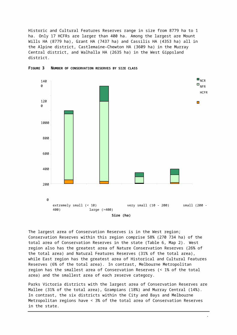
3
The AAV Site Register broadly categorises Indigenous sites into 17 types ranging from art sites to scarred trees and fish traps to stone structures. Across the entire park and reserve system, 90% of all sites are of five site types: Artefact Scatter (33%), Hearth (5%), Mound (3%), Scarred tree (29%), and Shell Deposit (20%). Rock Art, Grinding Grooves, and Stone Arrangements are the least represented sites within parks and reserves. The representation of sites in Conservation Reserves differs from that across the parks and reserves system as a whole. More than 50% of Aboriginal Places, Fish Traps, Mounds, Scarred Trees and Stone Structures found in parks and reserves occur in Conservation Reserves. However, there are no Grinding Groove sites in Conservation Reserves, and Conservation Reserves account for less than 10% of Shell Deposit sites recorded within parks and reserves.
The occurrence of sites within reserve categories varies across site types. All Conservation Reserve records of Stone Structures and Stone Arrangements are in Natural Features Reserves, and over 50% of records for most other site types also occur in Natural Features Reserves. The only exception is Scarred Tree sites, of which 48% of Conservation Reserve records occur in Historic and Cultural Features Reserves, and only 39% are located in Natural Features Reserves. Aboriginal Places are the most frequent sites within Nature Conservation Reserves (50%).
Indigenous sites are concentrated within individual reserves (Table 19). More than 50% of all sites in Conservation Reserves are found in only 11 reserves. For two site types, Stone Arrangements and Stone Structures, all Conservation Reserve sites occur in single reserves. For eight site types (Aboriginal Places, Extraction Site/Quarry, Rock Wells, Rock Art, Scarred Trees, Stone Arrangements, Stone Structures and Fish Traps), more than 40% of sites are within a single reserve.
TABLE 19 CONSERVATION RESERVES WITH THE HIGHEST NUMBER OF EACH INDIGENOUS SITE TYPE
SITE TYPE RESERVE WITH MOST SITES NO. SITES % OF SITE TYPE
Aboriginal Places Mount Hope FFR (NCR) 3 50
Artefact Scatters Lake Timboram FFR (NCR) 52 8
Extraction Site/Quarry Buchan Caves Reserve (NFR) 4 44
Fish Trap Lake Condah WR (NFR) 57 95
Hearth Lake Heywood WR (NFR) 23 18
Human Remains River Murray Reserve (NFR) 12 32
Literature Reference Soaks BR (NFR) 4 25
Mound River Murray Reserve (NFR) 37 16
Rock Art Red Rock BR (NFR) 5 42
Rock Well Chesney Vale Hills H97 BR (NFR) 4 44
Scarred Tree Bumbang Island HA (HCFR) 640 46
Shell Deposits Bumbang Island HA (HCFR) 39 24
Sub Surface Cultural Deposits River Murray Reserve (NFR) 9 31
Stone Arrangement Lake Wongan WR (NFR) 1 100
Stone Structure Lake Condah WR (NFR) 60 100
Aboriginal historical places
In addition to Indigenous sites, AAV records Aboriginal historical places. Aboriginal historical places are places of contemporary significance to Aboriginal communities, that is locations (post-contact) that are important because of their associations with, and cultural significance to, Aboriginal people. Such places may or may not contain archaeological remains. For example, a historical place could include the foundations of a mission building, or a massacre site at which no physical remains survive.
Of the 92 recorded Aboriginal historical places listed by the AAV that are within parks and reserves, 44% occur in Conservation Reserves. The 35 Aboriginal historical places recorded in Conservation Reserves are in 23 reserves, which is less than 1% of all Conservation Reserves (Table 20). Most of

3
these reserves (over 90%) are Natural Features Reserves, less than 10% are Nature Conservation Reserves, and none are Historical and Cultural Features Reserves.
TABLE 20 NUMBER AND PERCENTAGE OF CONSERVATION RESERVES WITH KNOWN ABORIGINAL HISTORICAL PLACES FOR EACH CATEGORY
RESERVE TYPE NO. RESERVES WITHABORIGINAL HISTORICAL PLACES
NO. ABORIGINAL HISTORICAL PLACES
RESERVES WITH PLACES AS A % OF ALL RESERVES
NCR 2 3 < 1
NFR 21 32 1
HCFR 0 0 0
Total 23 35 1
3.1.7 Visitors services
Over 90% of Conservation Reserves have no Visitor Sites1. In contrast to Parks, most have few visitors and visitor monitoring is not usually undertaken. Only 4% of all Conservation Reserves have one or more Visitor Sites recorded in the Levels of Service database. Of the 94% of Conservation Reserves that are not included in the database, it is assumed that most have few visitors and novisitor facilities.2
The greatest number of Conservation Reserves with Visitor Sites are Natural Features Reserves (82), which have more than four times as many reserves with Visitor Sites than both Nature Conservation Reserves (18) and Historic and Cultural Features Reserves (16). However, Historic and Cultural Features Reserves have the highest percentage of reserves with Visitor Sites: 15% of Historic and Cultural Features Reserves have Visitor Sites, compared with less than 5% of both Nature Conservation and Natural Features Reserves.
Visitor sites
Visitor numbers
Although 43% of Conservation Reserves with Visitor Sites have 5000 or fewer visitors per year, each Conservation Reserve category has at least one reserve that is estimated to receive over 50 000 visitors per year (Table 21). These high-visitation reserves (Table 22) comprise less than 10% of each reserve type with Visitor Sites and are located across six Parks Victoria districts.
TABLE 21 VISITOR NUMBERS FOR CONSERVATION RESERVES WITH AT LEAST ONE VISITOR SITE
RESERVE CATEGORY
VISITOR NUMBERS (' 000/YEAR)
< 5 5 – 10 10 – 50 > 50 NOT AVAILABLE
NCR 11 4 2 1 0
NFR 33 26 14 7 2
HCFR 6 4 4 1 1
Total 50 34 20 9 3
1 A visitor site is defined as a destination visitors go to that have four or more ‘attributes’ such as car parking and signage or
ranger presence and risk mitigation. Infrastructure such as roads, bridges and walking tracks is not currently counted as visitor sites. Information on infrastructure such as condition is recorded in the Maximo database but was not included in this overview.
2 Source of data: PV Levels of Service (LOS) database. Note that many reserves have more than one visitor site. For example, Murray River Reserve has >70 sites and the relevant data is listed for each in the database. For reserves with more than one Visitor site, the highest categories recorded for visitor numbers and service levels were used.
3
TABLE 22 CONSERVATION RESERVES WITH OVER 50 000 VISITORS PER YEAR
RESERVE CATEGORY RESERVE (SITE) PARKS VICTORIA DISTRICT
NCR Red Bluff Flora and Fauna Reserve* East Gippsland
NFR Vaughan & Glenluce Mineral Springs Reserve (day visitor area)
Murray Central
Rosebud Foreshore Reserve Mornington/Westernport
Buchan Caves Reserve East Gippsland
Trentham Falls Scenic Reserve (picnic area) Grampians
Red Cliffs River Reserve Mallee
Stevensons Falls Scenic Reserve West Coast
Tower Hill State Game Reserve (picnic area and visitor centre)
West Coast
HCFR Maldon Historic Reserve (Mount Tarrengower) Murray Central
* visits associated with surf carnival on adjacent beach.
Levels of Service
There are five classes of service level. Briefly, the classes are:
• Very Basic service level — Visitor Sites are remote with no built facilities provided. Typical visitors to these areas are self-sufficient, highly experienced in their preferred activity, active recreationists.
• Basic service level — Visitor Sites typically have walk-in, boat, or weather dependent vehicle access and have few facilities. Visitors to these areas are usually independent and experienced park visitors.
• Mid-service level — Visitor Sites are described as natural settings with reliable access, and generally have toilets, BBQs and picnic tables. Visitors include both active and passive recreationists seeking some facilities in a predominantly natural or cultural setting.
• High service level — Visitor Sites are highly accessible developed sites with many facilities.Visitors to these areas include tourists and park visitors seeking quality facilities in predominantly natural or cultural settings.
• Very High service level — Visitor Sites are highly developed with a full range of facilities. Visitors are tourists and park visitors seeking comfort and convenience in a popular/icon park.
Service levels within Conservation Reserves that have Visitor Sites range from Very Basic to High (Table 23). For each reserve category, most reserves have Basic service levels. Only two reserves are listed as High service level; Buchan Caves Reserve and Point Hicks Lightstation Reserve, both Natural Features Reserves (East Gippsland district). The highest service level for Nature Conservation Reserves and Historic Reserves is Mid level. The Nature Conservation Reserves with mid-level services are Red Bluff Flora and Fauna Reserve (East Gippsland district), Kings Billabong Wildlife Reserve (Mallee district) and Floating Islands Reserve (West Coast district).
High visitation levels correspond with High service levels in only one case: Buchan Caves Reserve. Most (78%) high visitation Conservation Reserves have Mid level services. Similarly, Conservation Reserves with High service levels are not restricted to the larger visitor number classes. For example, Point Hicks Lightstation Reserve is estimated to have only 5000 – 10 000 visitors per year.

Environment No. projects 512 325
% of budget 57 30
3
TABLE 23 LEVELS OF SERVICE FOR CONSERVATION RESERVES WITH AT LEAST ONE VISITOR SITE
RESERVE CATEGORY
SERVICE LEVEL
BASIC MID HIGH NOT AVAILABLE
NCR 15 3 0 0
NFR 53 25 2 2
HCFR 9 7 0 0
Total 77 35 2 2
3.2 ASSESSMENT OF MANAGEMENT ACTIVITY
There is a perception that in the context of managing the entire parks and reserve system, reserves are likely to be under-resourced compared to parks. In the absence of a comprehensive statewide audit of staffing levels and on-ground works undertaken in Conservation Reserves, the following analysis of budget allocation and expenditure1 indicates an appropriate level of management activity inreserves.
The total operating Parks and Reserves budget for 1999–2000 Programs across the four key output areas (Environment, Heritage, Indigenous, and Visitor and Assets) was more than $25.5 million (Table 24). Of this total, approximately 12% was allocated to Conservation Reserves.
TABLE 24 LEVEL OF ACTIVITY (OPERATING BUDGET) BY KEY OUTPUT AREAS FOR 1999–2000
OUTPUT AREA PARKS RESERVES REGIONAL PARKS
METRO PARKS
PIERS &JETTIES
ALL a TOTAL
b 131 0 0 968b 13 0 0 $5 838 581
Heritage No. projects 15 1 25 20 0 11 72
% of budget 13 < 1 26 53 0 8 $937 080
Indigenous No. projects 19 2 4 4 0 3c 33
% of budget 56 7 13 5 0 19 $360 150
Visitor and No. projects 35 1 7 13 14 0 70Asset % of budget 35 < 1 6 13 46 0 $18 460 000
a Statewide projects or allocations across more than one park typeb Regional park allocations included with Conservation Reservesc Allocation to a number of parksd Includes budgets for lighthouse reserves as NFRs
The total operating budget for 1999–2000 allocated to Conservation Reserves, across the four output areas, was approximately $3.1 million. Environmental management projects comprised the largest budget allocation made to Conservation Reserves (56%, including any Regional Park projects), with 35% allocated to Visitor Management projects, 8% allocated to Heritage Management projects and 2% allocated to Indigenous Management projects (Table 25).
1 Source of data: PV annual program budget allocation and expenditure. Note that budgets for salaries and other activities not allocated at a park or reserve level, and funding from other sources such as external National Heritage Trust and CMA grants, are not included in the analysis.
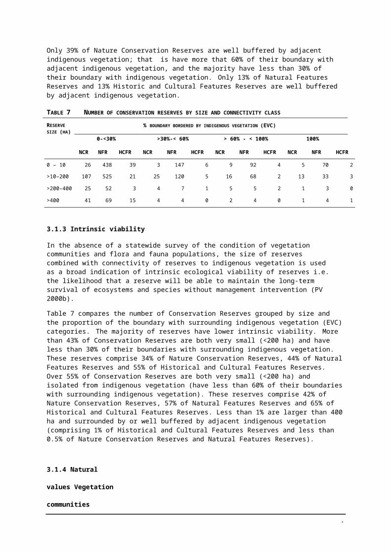
NO. OFPROJECTS
% TOTALBUDGET
NO. OFPROJECTS
% TOTALBUDGET
NO. OFPROJECTS
% TOTALBUDGET
NO. OFPROJECTS
% TOTALBUDGET
NCR NA NA 0 0 1 11 0 0
NFR NA NA 8 34 3 89 7 100
HCFR NA NA 13 35 0 0 0 0
Statewide or combination
NA NA 4 31 0 0 0 0
Total 325 100 25 100 4 100 7 100
3
TABLE 25 PERCENTAGE OF CONSERVATION RESERVES (OPERATING BUDGET) FOR EACH RESERVE TYPE
RESERVE CATEGORY
ENVIRONMENT HERITAGE INDIGENOUS VISITOR & ASSETS
NA Data not available
Environment Management Activity
The Environment Management Program is characterised by a large number of low to medium costs (in the order of $2000–10000) projects, undertaken mostly in parks but also in reserves, across eight program areas: Pest Plant Control, Pest Animal Control, Grazing, Catchment Management, Threatened Species Management, Native Animal Management, Marine, and Fire Management. It excludes any activities undertaken by reserve staff using recurrent funding.
Conservation Reserves were allocated 30% of the total Environment Management Program operating budget (which also included any Regional Park activity) (Table 25). Although National Parks Act parks received the greatest budget, the average operating budget allocated per project did not vary greatly between park type: Conservation Reserves were allocated $5433/project, Metro Parks & Waterways$5547/project and National Parks Act parks $6535/project.
Heritage Management Activity
The Heritage Management Program is characterised by a relatively small number of high-cost (many in the order of $50 000) projects undertaken at a small number of sites in parks or reserves. It excludes any activities undertaken by reserve staff using recurrent funding.
Of the Heritage Management Program operating budget for 2000–2001, 26% was allocated to Conservation Reserves. This was abnormally high due to a high level of externally funded expenditure on historic buildings, including lighthouses on reserves.
Most projects were within Historic and Cultural Features Reserves (52%), while 32% were within Natural Features Reserves and 16% of projects were statewide or multiple-park projects. Approximately one third of the Heritage Management budget for Conservation Reserves was allocated to each of these areas (35% to Historic Reserves, 34% in Natural Features Reserves including lighthouse reserves, and 31% to statewide or multiple park projects). No Heritage management activity occurred within individual Nature Conservation Reserves. Individual reserves that received the largest amounts were Tower Hill Wildlife Reserve (NFR in West Coast) (20.5%), Days Mill Historic Reserve (HCFR in Murray Central) (8.2%) and Gabo Island Lighthouse Reserve (classified as a NFR in East Gippsland) (5.5%).
Indigenous Management Activity
The Indigenous Management Program is characterised by a relatively small number of medium to high-cost (in the order of $20 000) projects, including both protection works and archaeological survey undertaken in a small number of parks or reserves. It excludes any activities undertaken by reserve staff using recurrent funding.
Conservation Reserves received 13% of the Indigenous Management Program funding. Three projects were conducted in Natural Feature Reserves and one in a Nature Conservation Reserve. Koorangie Wildlife Reserve (NFR, Murray Central) and Bishops Mitre Rock Scenic Reserve (NFR West Coast) received the most funding allocated to Conservation Reserves: 64% and 21% of the total
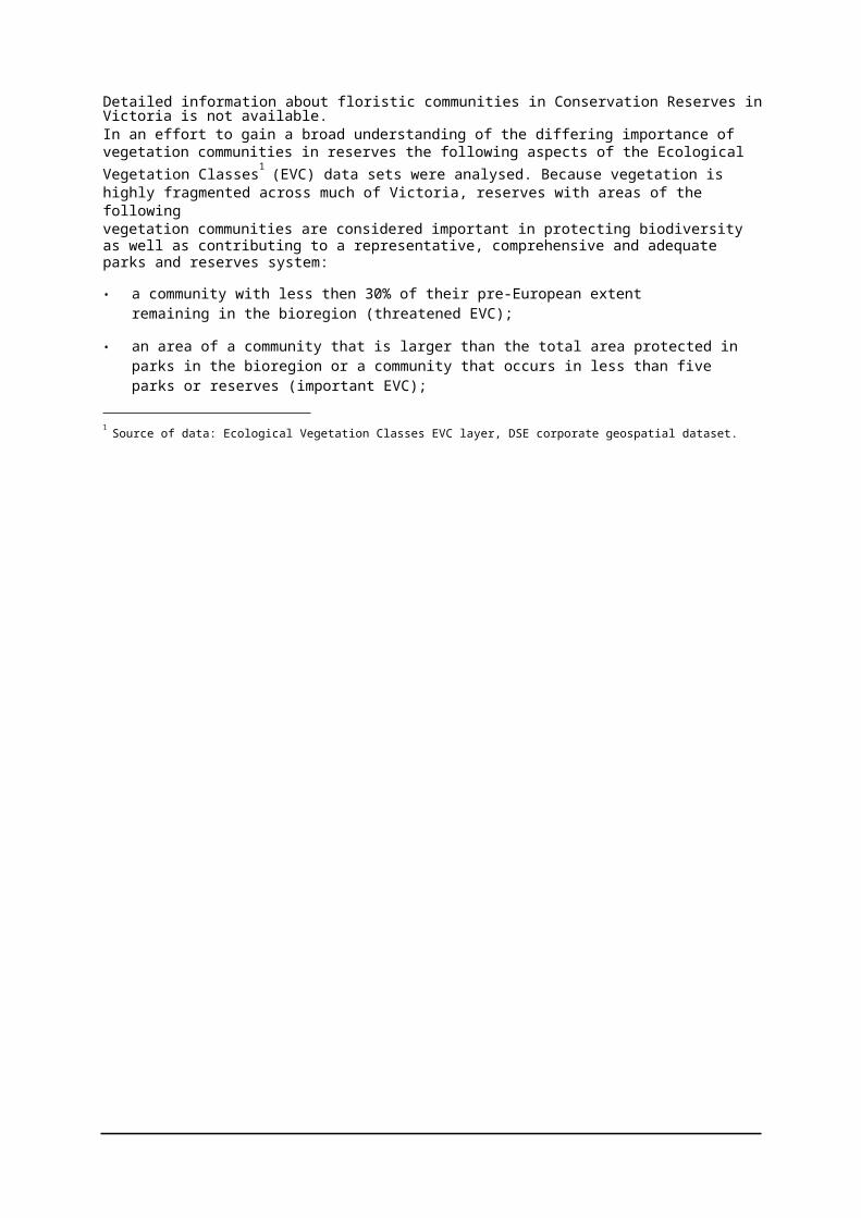
3
respectively. Other Conservation Reserves that received funding for indigenous projects were Point Hicks Lighthouse Reserve (classified as a NFR in East Gippsland), and Red Bluff Flora and Fauna Reserve (NFR, East Gippsland).
Visitor and Asset Management Program
The Visitor and Asset Management Program is characterised by a relatively small number of one-off strategic and high-cost projects undertaken mostly in parks and excludes any activities undertaken by reserve staff using recurrent funding.
Conservation Reserves Visitor Management activity represented 6% of the total budget within this output area.
All projects allocated budget from the 2000–2001 Visitor Management Program were in Natural Features Reserves; no projects occurred within Nature Conservation Reserves or Historic Reserves. Buchan Caves Reserve (NFR) received the most funding (67%), while three reserves received the remaining funding: Murray River Reserve (NFR Murray Central and Mallee districts) (14%), Wilsons Promontory Lighthouse Reserve (classified as a NFR in West Gippsland) (10%) and Tower Hill Wildlife Reserve (NFR in West Coast) (9%).
Improvements to the financial and budget systems and linkages between these and management systems during 1999–2000 enable automatic reporting of budget and expenditure for Conservation reserves by output areas.
The total expenditure for 2000–2001 across five output areas, including Environment, Heritage and Indigenous, and Visitor Services was approximately $15.8 million (Table 26). Of this total, approximately 8% was allocated to Conservation Reserves. Environment Management projects comprised the largest allocation made to Conservation Reserves (71%), however 10% was allocated to Asset projects and 11% to Visitor Services projects, and 9% to Cultural Heritage projects.
TABLE 26 LEVEL OF ACTIVITY (EXPENDITURE) BY OUTPUT AREAS FOR 2000-2001
OUTPUT AREA PARKS RESERVES REGIONAL PARKS
METRO PARKS
PIERS &JETTIES
TOTAL
Environment No. of projects 719 265 67 152 3 1206
% of expenditure 72 14 26 14 0 $3 677 995
Cultural No. projects 56 32 5 39 0 132(Heritage andIndigenous) % of expenditure 36 17 8 48 0 $959 288
Assets No. projects 338 37 12 155 0 542
% of expenditure 66 5 23 32 0 $4 776 612
Visitor No. projects 257 41 20 296 0 614Services % of expenditure 37 5 23 61 0 $5 773 897
Organisational No. of projects 70 6 3 85 0 164Performance
% of expenditure 62 2 16 34 0 $646 865
Further improvements to the budget and reporting systems allow a breakdown of the annual budget by park type and the five agreed output areas: Natural Values Management (NVM), Cultural Values Management (CVM), Fire Management (FM), Visitor Services Management (VSM), and Operational Performance (OP).
Of the total budget of $18.5 for 2001–2002, approximately 12% was allocated to Conservation Reserves (Table 27). Natural Values Management projects comprised the largest allocation made to Conservation Reserves (62%), with 26% allocated to Visitor Services and 12% to Cultural Heritage projects.

3
TABLE 27 LEVEL OF ACTIVITY (OPERATING BUDGET) BY OUTPUT AREAS FOR 2001–2002
OUTPUT AREA PARKS RESERVES REGIONAL PARKS
METRO PARKS
PIERS & JETTIES
TOTAL
NVM No. projects 236 574 115 53 3 981
% of budget 29 22 2 47 0 $7 336 499
CVM No. projects 30 41 27 6 0 104
% of budget 8 0 25 67 0 $1 195 658
VS No. projects 67 373 224 37 0 701
% of budget 65 19 5 10 0 $9 726 408
FM No. projects 3 2 2 4 0 11
% of budget 23 0 0 77 0 $77 150
OP No. of projects 4 8 9 5 0 26
% of budget 58 6 0 37 0 $135 742
3.3 INFORMATION GAPS AND DATA LIMITATIONS
This strategy draws on material collated from electronic databases, maps, aerial photographs, research documents and published reports. These sources vary in their age and hence the degree to which they reflect the current situation. All attempts have been made to ensure that the information contained in this report is relevant, accurate and up-to-date.
Parks Victoria and DSE use different GIS systems (MapInfo and Arc View respectively), and translation of data between the systems can be problematic.
A whole-of-catchment and bioregional perspective from outside the reserve boundary is crucial for reserve planning. However, information systems available to PV staff are often limited to the parks and reserves system.
Land tenure information
• DSE and PV maintain separate data systems. Parks Victoria has no direct access DSE systems and useful data may not be readily accessible. Parks Flora and Fauna (PFF) within DSE maintains a Parks and Reserves Information System (PRIMS) and provides regular updates about reserves managed by Parks Victoria. The information from PRIMS is duplicated in the PV Parks and Reserves register. The register indicates whether reservation status is in accordance with the LCC/ECC recommendation but does not include comprehensive information on reservation status, land tenure or reservation history for every reserve. PV has no direct access to this information which recorded on DSE’s statewide set of parish plans and only partly included in the DSE Land Information System (LIMS). There is some confusion in PV about which part of DSE is responsible for managing the data; for example, Land Victoria or PFF.
• An ongoing process is in place between PFF and Parks Victoria to correct reserve boundary and other details, and the information is regularly updated. However, these updates are not consistently adopted by other areas of DSE, and can lead to conflicting information about current reserve tenure and area, particularly between regional staff.
• The Parks and Reserves register and the derived GIS spatial layer Park_Bound does not include parks and reserves where Parks Victoria has been appointed the Committee of Management, for example Lake Corangamite WR, but will be included in future updates.
Land (reserve) managers
• Within DSE, PFF advises about all reserves Parks Victoria is responsible for managing through the parks and reserves register. As for land tenure this information is regularly updated between

3
DSE and PV. However these updates are not available or adopted by other areas of DSE and can lead to conflicting information about current reserve managers and confusion for staff and stakeholders.
• Within DSE, Land Victoria is responsible for overseeing committees of management. Details of committees of management for PV-managed reserves or about reserves where PV is the committee of management are out-of-date and often inaccurate. As is the case with land tenure, PV has no direct access to this data.
Licences and leases
• Land Victoria manages licences and leases for resource use such as grazing, firewood collection, and honey production. The processes are inadequate to ensure legislative compliance because much of the information on reservation status and reserve managers is inaccurate or out-of-date.
• Parks Victoria has completed an audit of reserves licensed for grazing stock in the Murray Central district, and audits of two other districts is underway. The process involves much data collection and correction because records extracted by Land Victoria are not always comprehensive or accurate.
Species records
• The data contained in the Flora Information System and the Atlas of Victorian Wildlife comes from a combination of incidental records and systematic surveys. The data varies in accuracy, precision and reliability. The relative lack of knowledge about the distribution of invertebrate and non-vascular plant species means that records are weighted towards the less cryptic elements of flora and fauna, i.e. vascular flora and vertebrate fauna.
• The records of threatened species analysed were limited to those less than or equal to 30 years ago. If a species has not been recorded in the last 30 years it is assumed no longer present. In some reserves this is case; there has been a serious decline in biodiversity, which is particularly evident in the loss of medium and small mammal species, as a result of vegetation clearance and habitat fragmentation across the landscape. In some cases it is likely that the reserve still provides suitable habitat for certain species, but the nature of their distribution and/or their biology limits the likelihood that they will be observed and recorded. In other cases there is a lack of recent information. Many of the first systematic surveys in Victoria were undertaken in the 1970s to support the former Land Conservation Council studies. Records are likely to drop out if no further surveys have been made or incidental records added.
• There is a huge lack of basic flora and fauna information; approximately 70% of reserves have no flora and fauna records in the DSE statewide databases and are unlikely to have been surveyed. Of the 30% with records, the number that have been systematically surveyed is likely to be low.
• Current records entered by reserve staff are immediately accessible, but updates from and to the DSE statewide databases (that is, from outside PV such as DSE, researchers and field naturalists) can be over a year apart. Reconciling the differences between species lists from the two sources can be problematic.
Ecological Vegetation Classes
• EVCs are modelled to represent the most detailed level of vegetation typology available. They consist of one or more floristic communities that exist under a common regime of ecological processes within a particular environment. Descriptions and mapping of EVCs has been completed for much of the state and compiled as statewide layer. However, mapping for north- western Victoria (562 or 21% of reserves: that is 24% of NCRs, 21% of NFRs and 5% of HCFRs) will not be completed until the end of 2003.
• The scale of the EVC mapping (1:100 000 or 1:25 000) leads to misleading results for areas with low density of vegetation cover, and particularly for the small reserves. Over 50 reserves have vegetation that is not classified as any EVC because of low tree cover, and many others have parts with vegetation that is not classified. The scale of the EVC mapping and the reserve boundary layer needs to be kept in mind when interpreting the EVC information (Figure 11).
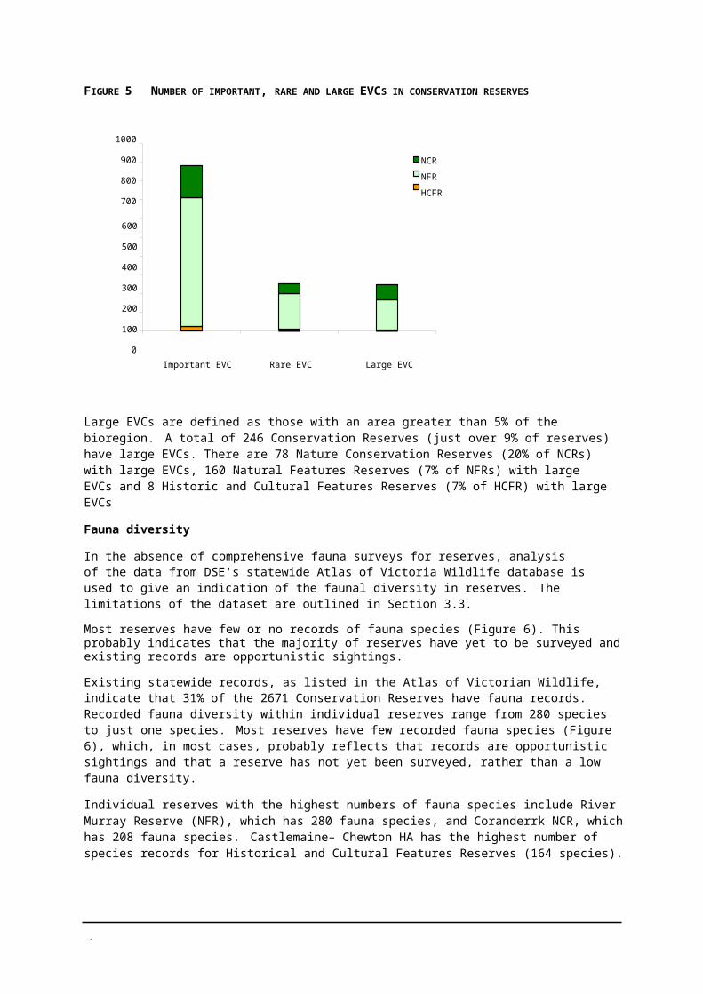
3
N
N
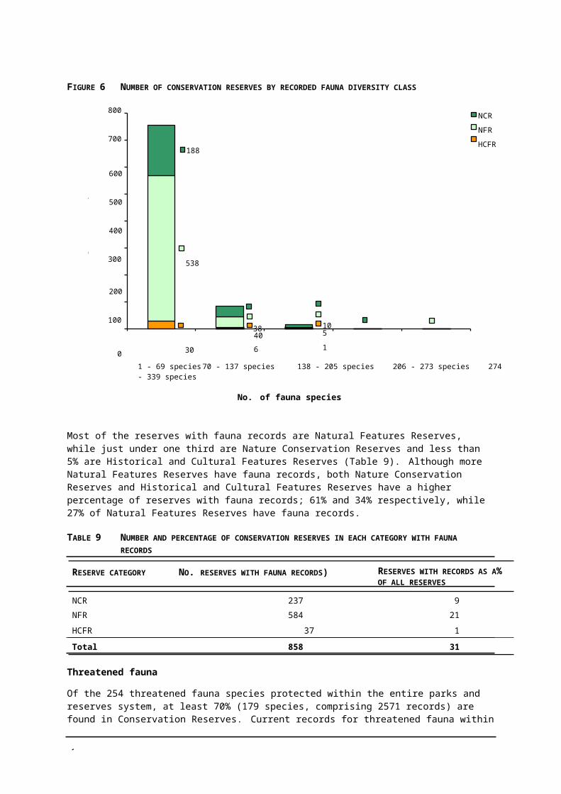
3
FIGURE 11 LIMITATIONS OF EVC MAPPING FOR LITTLE DALYENONG FLORA RESERVE (NCR)
EVC mapping (top) and remaining vegetation from aerial photograph (bottom). D = reserve boundary

3
• EVC mapping is not ground truthed. Like most developmental projects, EVCs are subject to continuous improvement and changes.
Condition
• There is no agreed vegetation condition assessment method, but several methods are in use by PV and DSE.
• There are no assessment methods for habitat or species condition.
• Methods for assessing vegetation condition have yet to demonstrate measurability and repeatability, over time and consistency of results by different assessors.
• The DSE habitat hectare method requires benchmarked EVCs. Less than a quarter of Victorian EVCs have been benchmarked, and these are mostly from North Central Victoria.
• The PV method (developed by Ballarat University) requires identification of a ‘good’ condition example for benchmarking, which can be problematic in small reserves.
• There are no defined or agreed targets for ecological management.
Risks to environmental values
• There are no agreed statewide data or contexts for assessing impacts.
• There are difficulties in accessing CMA-based assessments of pest plants and animals, which is currently not available from the DSE Corporate Library; for example, CMA Rabbit Priority Control Zone maps.
• DSE layers for salinity, erodibility, flood-prone areas and land use are in development initially for CMAs, then statewide, to be available through the DSE corporate library.
Heritage values
• A large proportion of reserves has yet to be comprehensively surveyed. A large number of places still need to be recorded, although the majority of significant places have probably been identified.
• There may be errors of omissions in the Maximo database, because sites managed by Parks Victoria may have been misidentified and deleted from the inventory. In addition, since site locations are mostly based on map grid references, some may not match the current GIS-based reserve areas. Some sites have yet to be matched with a park or reserve.
• Survey in the past focused on themes such as gold mining, and did not collect data for other types of places such as settlement sites.
• While the Heritage Strategy (PV 2002b) establishes clear directions and guidance for the management of places in reserves, there is no statewide context for determining management priorities.
Indigenous values
• Very few reserves have been surveyed for sites. The likelihood of finding new sites in particular areas is high. For example, five new sites were identified during recent site inspections of ten reserves.
• While there is clear guidance for the protection of sites and places in reserves (PV 2002a), there is no statewide context for determining management priorities.
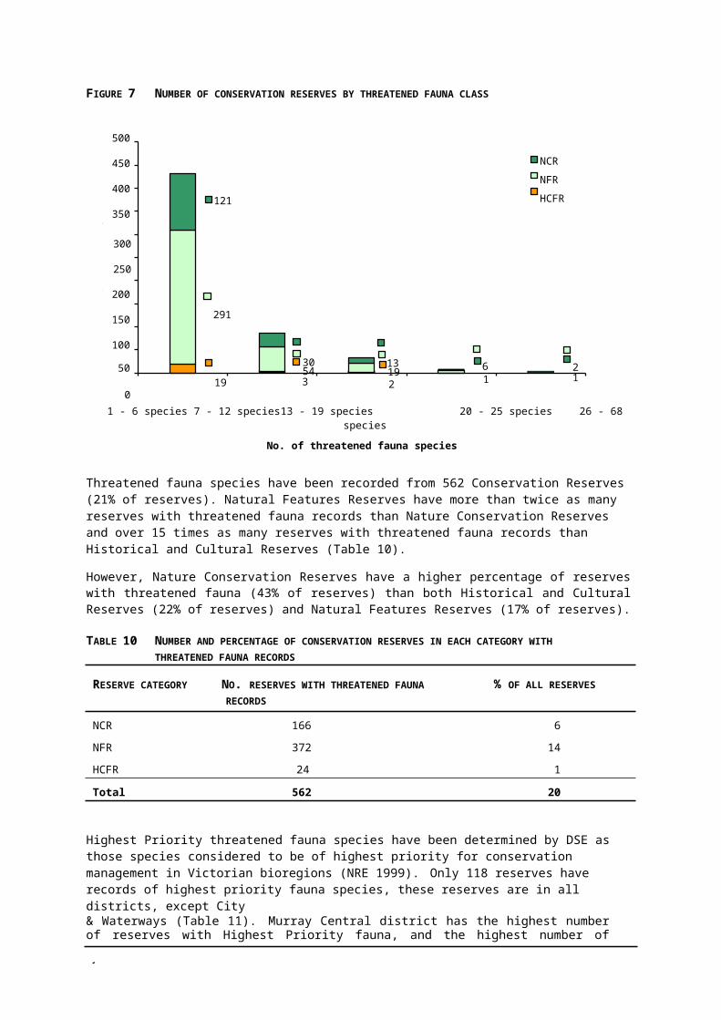
4
Visitor services
• The focus of data collection for Levels of Service (LOS) was parks not reserves. Comprehensive date on reserves may not be included for all districts. The LOS data includes only reserves with recorded visitor sites; that is, built facilities. Most reserves have no visitor sites and are not included.
• Actual visitation may be underestimated for a relatively small number of reserves; for example, high seasonal visits to Wildlife Reserves where hunting is permitted, which have no facilities.
• As for parks, annual numbers of visitor days are estimated and not measured. The lowest category is between 0 and 5000.
• Access roads and tracks to or through reserves may not be included, particularly when managed by VicRoads or Shires/Councils.

4
4 MANAGEMENT DIRECTIONS
This section supports the legislative management objectives for Conservation Reserves detailed in Chapter 2 by providing further guidance for decision-making in planning and managing Conservation Reserves. This section describes directions for reserve management and explains their application.
These management directions have been developed to facilitate decision-making about individual reserves, to ensure a consistent approach to reserve management, and to help set priorities. The directions cover six key result areas:
• management planning;
• information needs;
• conservation of natural values;
• conservation of heritage values;
• conservation of Indigenous values; and
• provision of visitor facilities or access.
MANAGEMENT PLANNING
ISSUE MANAGEMENT DIRECTION
Reserve management statement
Instead of comprehensive management plans, reserve management statements will generally be prepared for Conservation Reserves (see Appendix 1).
Management plan (PV initiated) Management plans will usually not be developed forConservation Reserves. If plans are required for reserves (see Appendix 2), management plans will be developed in accordance with the PV standards and processes including community consultation required for the development of plans for national parks.
Explanation
The development of management plans for protected areas is costly in terms of operational budgets and staff time and take at least a year to complete. With almost 2800 reserves, the development of plans for all reserves would be a major undertaking and a considerable drain on resources into the foreseeable future. Consequently, DSE and PV have agreed to develop a strategic basis for managing reserves instead of developing management plans for all reserves. In accordance with legislation, management plans for parks and Reference Areas will continue to be prepared.
There are approximately 30 existing management plans for individual reserves and several under development. Plans will not be considered for reserves unless a reserve meets at least three criteria, such as high natural values, high visitation, and a proposed level of service that is inconsistent with the reserve category (see Appendix 2).
From time to time management plans are and will continue to be initiated by other agencies, such as salinity plans by DSE and Neighbourhood Environment Improvement Plans (EIP) by the EPA. PV will support and encourage the development of management plans for conservation reserves (all reserve categories) by other agencies subject to agreement that the plan not be approved without PV District Chief Ranger agreement on an implementation framework. District Chief Ranger approval is required
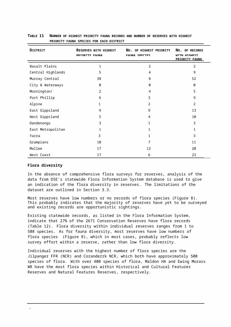
4
for PV involvement in planning initiated by other agencies, and particularly as a partner in Neighbourhood EIPs. An approach consistent with PV current practice will be encouraged.
For the majority of Conservation Reserves planning will be streamlined through the development of a Conservation Reserve Management Statement. The statement identifies short and long-term natural values, heritage values, indigenous values and visitor services management objectives (see Appendix 1). Annual priorities for on-ground action to be incorporated into the appropriate program area will implement these objectives.
INFORMATION NEEDS
ISSUE MANAGEMENT DIRECTION
Information needs Give priority to collecting basic information for all reserve.
For priority reserves and reserves with on-ground work programs ensure adequate knowledge of values and risks.
Explanation
The majority of reserves have not been comprehensively surveyed for flora and fauna or cultural sites. Vegetation mapping, available for 75% of reserves, is modelled at a broad scale and not necessarily based on actual vegetation surveys. The extent of information gaps for Conservation Reserves mean that the collection of basic information on natural and cultural values in reserves is a priority.
While the completion of comprehensive surveys of all reserves might be a long-term goal, it is currently well beyond the resources of reserve managers. Nevertheless considerable progress can be made with the assistance community groups and individuals interested in recording values and other information. Focussing their efforts on both priority reserves and reserves where the values are not recorded will be of greatest benefit in the short-term.
CONSERVATION OF NATURAL VALUES
ISSUE MANAGEMENT DIRECTION
On-ground work program priorities
In the short-term, undertake on-ground work programs to maintain or restore reserves with higher natural values where the risk is manageable.
Monitoring priorities Monitor reserves with lower value, in poor condition and where the risk is intractable, to detect any rapid decline in condition.
Explanation
There is a perception that Conservation Reserves protect few important natural values and that past resource use has degraded the condition of reserves beyond repair. This is not the case. Despite a lack of a comprehensive survey there are records of threatened flora or fauna species in more than 20% of reserves. Almost half of all reserves protect valuable remnants of vegetation communities considered threatened because less than 30% of the pre-European extent remains. Clearly Conservation Reserves are important for biodiversity conservation in Victoria.
In managing natural values it is important to make wise use of the limited available resources by giving priority to projects most likely to achieve the best outcomes. Hence management of threats and threatening processes to reserves with higher values in good condition is a priority compared to treating intractable problems such as some weed invasions or reserves already in poor condition. Reserve managers need to use values, condition and risk as indicated below to determine priorities for natural values management.
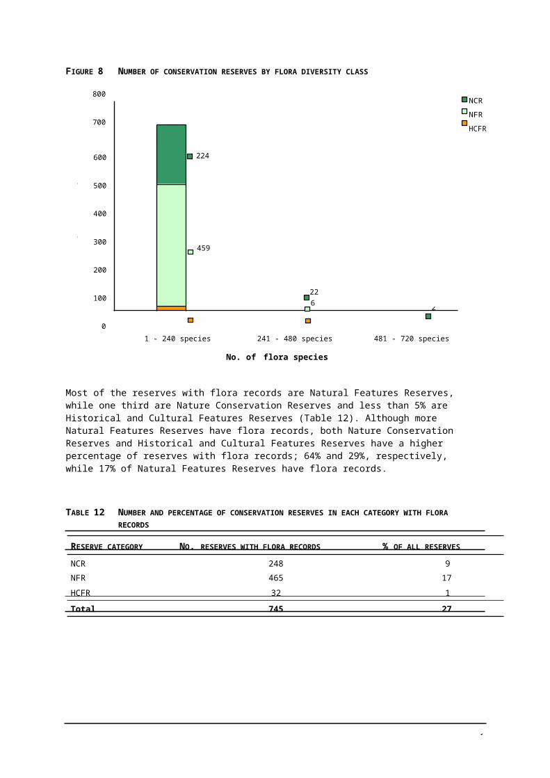
4
.
HHL HHM MHM HLH HLL HLM MMH LMM LLL
HML LHL HHH HMH MML LML MLL LMH LLM
MHL HMM MHH LHM LHH MMM MLM MLH LLH
H = Higher, M = Medium, L = Lower, arranged in order from left to right: values, condition, risk. Green = Higher management priority to maintain. Teal = Medium management priority to maintain. Purple = Low management priority to maintain. Red = High management priority to restore. Dark blue = Medium management priority to restore. Brown = Lower management priority to restore
CONSERVATION OF HERITAGE VALUES
ISSUE MANAGEMENT DIRECTION
Places listed on the Victorian Heritage Register
Do not allow to fall into disrepair and ensure that their conservation is not threatened. Manage in accordance with Heritage Victoria requirements and the Burra Charter.
All other places Protect all heritage places from avoidable damage and managesignificant heritage values in accordance with expert reports or by the application of the Burra Charter.
Explanation
Over 30% of all historic places (non-indigenous places) in parks and reserves are in just 168 reserves. Most of these reserves are Historic and Cultural Features Reserves but places are also found in Natural Features Reserves and Nature Conservation Reserves. It is thought that most significant historic places in reserves are known, however many relics and other evidence of former uses are probably still to be recorded.
PV manages all sites to protect their significance in accordance with the Burra Charter (ICOMOS 1999), the Heritage Act and other relevant legislation. The significance of places is defined by heritage experts. PV has developed an overarching strategy (PV 2002b) which details the key historic themes managed by PV. The themes guide priority setting particularly for presentation, promotion and developing strategic partnerships with local communities. Management of significant places and places representing a PV key historic theme is directed by expert reports or advice. The Heritage Act requires managers of places older than 50 years to ensure that they are not disturbed or destroyed, except in accordance with a consent under that Act. The most appropriate management of other places is usually to prevent avoidable damage of the place, its component parts and setting but allow natural processes of deterioration to continue.
CONSERVATION OF INDIGENOUS VALUES
ISSUE MANAGEMENT DIRECTION
All Indigenous sites (AAV registered or not)
Adequately protect sites consistent with the condition of the site and as agreed with all relevant Indigenous groups.
Explanation
Almost 40% of all sites found in parks and reserves are in just 241 reserves. It is anticipated that there are many unrecorded sites in reserves, as many reserves have never been surveyed. The majority of reserves with sites are Natural Features Reserves, but sites are also found in Nature Conservation Reserves and Historic and Cultural Features Reserves.
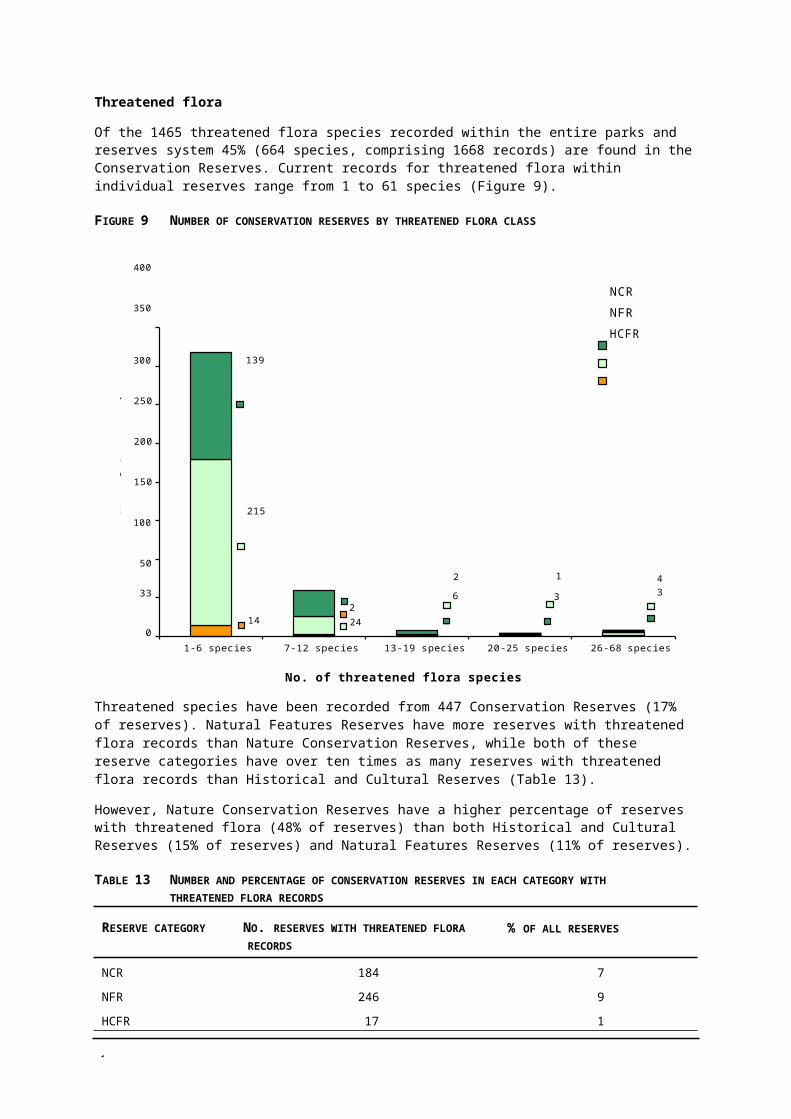
4
PV manages all sites and places in accordance with relevant legislation, has operation policies to guide management of sites and is committed to establishing partnerships all relevant Indigenous groups to improve management of reserves and sites in reserves. AAV (1997) describes how to record information on new sites and AAV (2000) defines the condition of sites and recommends a range of appropriate management actions.
PROVISION OF VISITOR FACILITIES OR ACCESS
ISSUE MANAGEMENT DIRECTION
Reserves with visitor sites
Reserves without visitor sites
Access
Infrastructure
In the short-term, maintain existing appropriate and safe facilities at visitor sites. Provide no new or upgraded facilities except for the protection of values. In the long-term maintain or downgrade facilities consistent with the level of use, reserve category desired levels of service (as outlined below), risk and Level of Service (LOS) direction rating.
Provide no new facilities. Subject to the availability of funding, give priority to site identification signage for reserves with regulations,>5000 visitors per year and in line with LOS high, mid and basic sites in that order.
Provide standards of access consistent with PV Roads Strategy (no upgrading of access roads).
Undertake regular inventory and condition assessments, and works to manage risk as required.
Guided tours Permit tours, provided they are consistent with the management objectives for the reserve category and level of service.
Explanation
The majority of reserves have low numbers of visitors and most have no visitor facilities. Only 29 have more than 10 000 annual visitors. Only 116 reserves have visitor sites with a range of facilities. Many are too small to sustain large numbers of visitors without compromising the purpose for their reservation.
Facilities and standards of access within and to reserves are mostly a legacy of past uses, developed at the discretion of former managers. Similarly much infrastructure such as bridges and fences is a legacy of past management. The maintenance of visitor facilities and roads and tracks is very costly.
In the short-term visitor management will promote best use of reserves with existing facilities and appropriate standards of access roads. Available resources are allocated on a statewide basis depending on the importance of the site and level of risk. Visitors should be directed to reserves with facilities or other areas (Shire or DSE) with facilities. Change in visitor use of a reserve or of visitor sites within a reserve may require periodic review of the levels of service direction rating.
In the long-term, the majority of Conservation Reserves will continue to have no visitor facilities. The future provision of visitor facilities at existing visitor sites needs to consider the primary purpose of the individual reserve, risks and level of use. The desired levels of service for reserve categories are:
NCR Regardless of visitor numbers, the appropriate level of service is Very Basic — no fireplaces or other built facilities, no signage other than site identification signs, access generally walking or limited vehicle. Provide no new facilities and decommission inappropriate facilities e.g. fireplaces. If necessary, re-direct public access rather than provide facilities, e.g. boardwalks, to minimise visitor impact.
NFR 0–5000 visitors — the appropriate level of service is Very Basic.
5000–10 000 visitors — the maximum level of service is Basic.
10 000–50 000 visitors — appropriate level of service is Basic to Mid.

4
No new or upgraded facilities (except to protect natural or cultural values).
HCFR Small reserves (<400 ha) regardless of visitor numbers — the appropriate level of service is Very Basic (other than signage for site protection).
Reserves > 400 ha
• with 0–5000 visitors — the appropriate level of service is Very Basic (other than signage for site protection).
• with 5000–10 000 visitors — the maximum level of service is Basic.
• with 10 000–50 000 visitors — the maximum level of service is Mid.
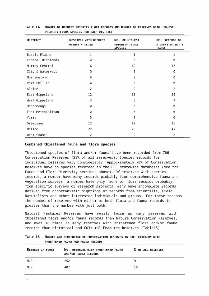
4
5 STRATEGIES FOR IMPLEMENTATION
This section documents statewide management strategies that address a range of actions that will lead to an overall improvement in the management of reserves. The strategies have been developed in response to the analysis of the information available for reserves, and to issues that were raised in discussions with reserve managers. Designed at the broader level, the strategies complement the directions set out in Section 4, which aim to clarify decision-making and management priorities for individual reserves.
The strategies are grouped under seven important performance areas. A summary of the relevant management issues or considerations follows the strategies to further explain the context for adopting the statewide strategies. To guide priorities and the allocation of resources to the most important activities, timelines and accountabilities have been assigned to each strategy.
5.1 LEGISLATIVE AND MANAGEMENT ARRANGEMENTS
STRATEGY ACCOUNTABILITY TIMELINE
Implement outstanding LCC/ECC recommendations by appropriate reservation.
DSE Ongoing
Initiate processes to reconcile data and licensing issues. DSE & PV Year 1
Ensure sustainability of resource use and adequate protection conditions in leases and licences.
Phase out resource uses that are incompatible with reserve management objectives.
DSE & PV Ongoing
DSE & PV Ongoing
Apply and implement regulations to Nature Conservation Reserves. DSE & PV Ongoing
Investigate making regulations for other reserve types. DSE Within 5 years
MANAGEMENT ISSUES AND CONTEXT
Conservation Reserves are mostly reserved under the Crown Land (Reserves) Act, however approximately 40% are not yet reserved as recommended by the LCC/ECC recommendations. Appropriate reservation will help resolve many existing boundary and encroachment issues. Reserves must be managed in accordance with Government-accepted LCC/ECC recommendations, but reserve managers must be aware of the current reservation status.
Information about reservation history and current status, and reserves where PV has been appointed the Committee of Management needs to be readily accessible. Land Victoria and other DSE units are responsible for issuing leases and licences for resource use in reserves, including timber harvesting, firewood collection, grazing, water diversions for irrigation, apiculture and commercial fishing. Some licensing of activities that are inconsistent with reserve management objectives is occurring as a result of inconsistent records about LCC/ECC recommendations and which reserves PV manages. For example, grazing licences have been issued for some Nature Conservation Reserves when both the management objectives and LCC/ECC recommendations prohibit grazing in these reserves.
The Crown Land (Reserves) Act allows for regulations to be made for reserves. The Land Act and Crown Land (Reserves) Act include some generic regulatory provisions, and there are specific regulations for State Game Reserves and proposed regulations for Nature Conservation Reserves to be made in 2003 (totalling 20% of reserves). Parks Victoria will undertake a communication program to inform reserve managers, DSE, neighbours, stakeholders, users and the broader community about new regulations and will implement a two-year transition phase before beginning enforcement.

4
5.2 RESERVE PRIORITIES
STRATEGY ACCOUNTABILITY TIMELINE
Prepare reserve management statements for 25 reserves selected from the 300 priority reserves at the top of statewide ranking of reserves (Appendix 3) and document the planned outcomes in individual reserve management statements (Appendix 1).
NPPS Year 1
Review reserves where works are currently scheduled in annual on-ground work programs against the statewide priority ranking of reserves.
Develop a three-year program to complete reserve management statements for 150 priority reserves.
Ranger in Charge (RIC)
NPPS & Chief Ranger (CR)
Year 1
Year 1
Review reserve priorities (Appendix 3), subject to the availability of new or improved data such as completed EVC mapping or bioregional planning priorities.
Review delivery of a three-year program including future resourcing implications for planning for all reserves and PVs capacity to improve management of reserves.
Subject to the outcome of the reviews in Year 3 develop and commence implementation of a rolling three-year program for development of reserve statements for all reserves.
NPPS Year 4
NPPS Year 4
NPPS & CR Year 4
MANAGEMENT ISSUES AND CONTEXT
Establishing systematic reserve priorities will allow resources to be allocated to where they will be most effective.
In the past, establishing statewide priorities for reserves has been hampered by a lack of a statewide perspective, lack of consistent and comparable data, and difficulty in apportioning relative importance to natural or cultural values. There is a perception, based on the LCC classification of reserves, that Nature Conservation Reserves have higher natural values, Historic and Cultural Features Reserves have higher heritage values and Natural Features Reserves have less values. Analysis of statewide datasets shows that higher values are not clearly grouped by reserve category but spread more broadly. Consequently, reserve priorities focus initially on reserves with an aggregation of natural and cultural values in a statewide context. Reserves have been assessed against nine criteria, grouped by the number of criteria met and sorted by area to establish a statewide ranking. The reserves at the top become priority reserves (Appendix 3).
An audit undertaken by DSE in 1996 documented a range of valuable information for many reserves, but there is still a lack of basic data, particularly on natural values, for many reserves. Reserve managers will need to apply local knowledge of reserve values to ensure that appropriate resources are allocated to key reserves not identified as highest priorities. Priority reserve rankings will need to be revised as additional information becomes available. Similarly if information about higher natural values in Natural Features Reserves and Historic and Cultural Features Reserves continues to be collected, the need for review of the LCC/ECC classification of reserves may need to be considered.
The capacity of Parks Victoria to undertake reserve planning and future resourcing levels will depend upon the extent of the emerging management challenge after three years, and will need to be reviewed.
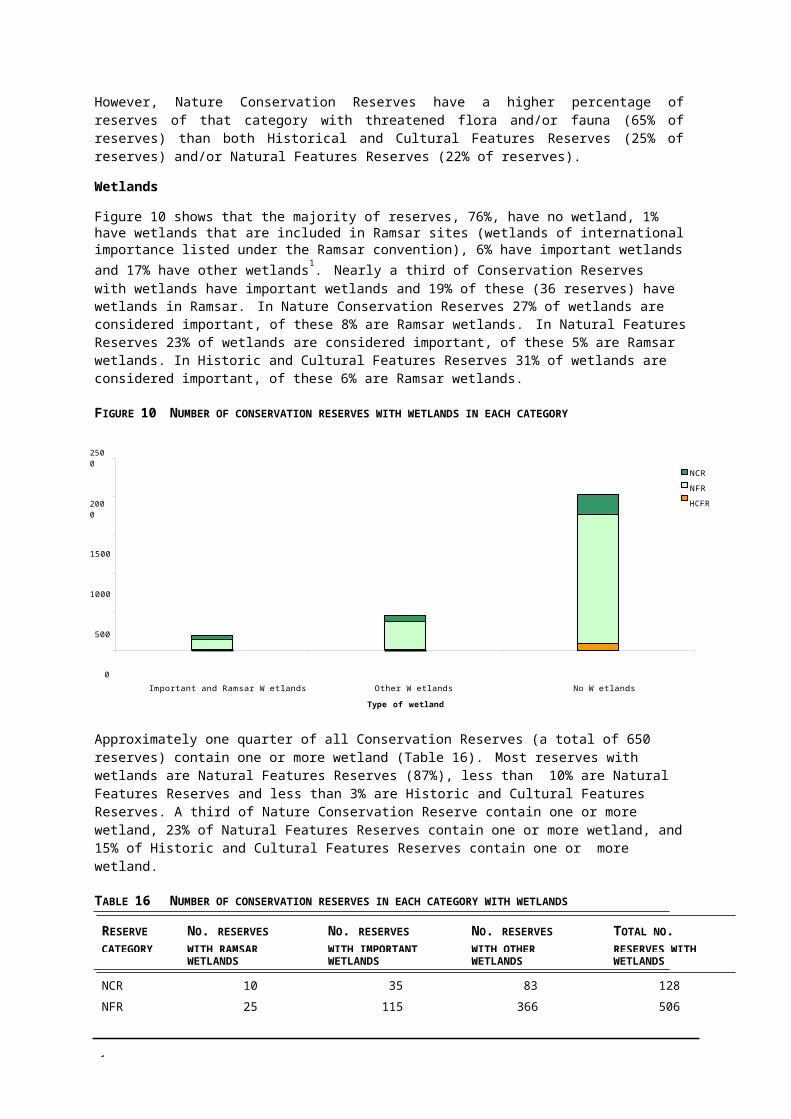
4
5.3 PLANNING AND WORK PROGRAMS FOR INDIVIDUAL RESERVES
STRATEGY ACCOUNTABILITY TIMELINE
Undertake streamlined planning to identify specific short-term and long-term management objectives for priority reserves.
Regional planners and reserve managers
Years 1–5
Give highest priority for action to programs to maintain or restore reserves with higher values where the risk is manageable.
Defer action in reserves that have lower values, are in poor condition and have intractable risk but monitor and take action to avoid any rapid decline in condition.
Develop a reserve management statement kit for staff and train regional planners and reserve managers.
Develop annual on-ground work priorities to implement the objectives described in reserve management statements and incorporate them into output area programs.
If available, implement approved management plans for reserves and relevant actions from plans from other agencies in annual work programs.
Analyse the extent of changes in the level of management activity in reserves resulting from the implementation of reserve management statements.
Review reserve statements and further refine the development process.
RIC Years 1–5
RIC Years 1–5
NPPS Years 1–2
RIC Year 1 and beyond
RIC Years 1–5
NPPS & RIC Year 3
NPPS Years 1 & 5
MANAGEMENT ISSUES AND CONTEXT
A proportion of management effort is directed to Conservation Reserves each year: over 200 projects and 10% of the total budget for natural values management, cultural values management, fire management and visitor services programs. Decisions on resource allocation to individual reserves consider some statewide criteria but in the absence of a strategic basis. Annual management programs for individual reserves are developed to progressively implement these objectives.
A streamlined planning process will ensure the development of desired outcomes of future management, to guide on-going work programs. Identifying achievable priorities for reserve managers is important in improving the overall health of the reserve system.
In the short-term there is scope to continue or redirect work programs to achieve key management objectives in priority reserves. However, in the longer term, increased resources are likely to be required to implement objectives in all reserves.
There are efficiencies to be gained by training reserve staff to undertake streamlined planning to agreed consistent standards.

4
5.4 INFORMATION COLLECTION AND MANAGEMENT
STRATEGY ACCOUNTABILITY TIMELINE
Encourage increasing assistance of Friends, Field Naturalists, educational institutions, reserve neighbours and community groups to increase knowledge of priority reserves.
For reserves lacking basic information, particularly environmental information, encourage and promote the collection of key data.
Improve the compatibility and access between PV and DSE systems, including flora and fauna data, and data beyond the reserve boundary.
Establish on-line access via the Web to enable PV staff and public to access to baseline reserve data.
Increase input of flora and fauna records by PV staff into PVs Environmental Information System (EIS), particularly from local records, and add records of new historic and indigenous sites into the PV historic places inventory and AAV register respectively.
RIC Year 1 and beyond
PV & DSE Years 1–5
PV & DSE Within 5 years
NPPS Within 5 years
RIC Year 1 and beyond
MANAGEMENT ISSUES AND CONTEXT
There is a lack of basic information about values in many Conservation Reserves. The statewide databases have no flora or fauna records for 70% of reserves. Vegetation mapping (Ecological Vegetation Class) is not available for 24% of reserves, mostly in north-western Victoria reserves where mapping is scheduled for completion in 2004. Generally, the condition of natural values has not been assessed. There is insufficient data to determine which reserves have lower values in poor condition.
While many reserves have not been surveyed, the most significant historic places in reserves have probably been identified. However, reserves have yet to be comprehensively surveyed for Indigenous sites, and many new sites and places may be found.
Nevertheless, reserves play an important role in biodiversity conservation and the protection of cultural sites. There is a perception that reserves protect few values, but threatened flora and fauna species have been recorded in 21% and 17% of reserves respectively. Over a third of the historic places and Indigenous sites recorded in parks and reserves are in Conservation Reserves. There is often considerable local knowledge about risks to the values of these reserves.
Information on visitor facilities in reserves with visitor sites is available in Parks Victoria's Levels of Service database.
5
5.5 COMMUNITY AND STAKEHOLDER PARTNERSHIPS
STRATEGY ACCOUNTABILITY TIMELINE
Promote complementary planning processes to other agencies planning for reserves and raise awareness of the role and management directions for reserves in CMA reviews.
Canvass options for increasing community involvement in improving management of priority and other reserves.
RIC Years 1 – 5
NPPS Within 5 years
Brief local officers of DSE and other agencies (including FFG and CMA staff) about the strategy and approach for priority reserves.
Establish partnerships with relevant Indigenous groups to manage Indigenous historical places and sites in reserves.
Consult reserve neighbours and local friends groups, Biodiversity Committee and relevant Field Naturalists about the management objectives for individual reserves, and discuss options and priorities for future involvement.
Environmental Chief Ranger, CR
PV Team Leader, Indigenous Cultural Heritage
Regional planners, RIC
Years 1 – 5
Within 5 years
Year 1 and beyond
Encourage increasing involvement of Friends, local Historical Associations and other interest groups in management of priority reserves and sites.
RIC Year 1 and beyond
Communicate information needs of reserves to PVs Research Partners.
NPPS, Research Partners
Within 5 years
Work towards adopting agreed method for assessing and measuring vegetation condition over time.
PV Within 3 years
MANAGEMENT ISSUES AND CONTEXT
Successfully eradicating many of existing and emerging threats and threatening processes to reserves is a challenge for many reserve managers because the problems also occur or arise beyond the reserve boundaries. Unless tackled within a whole-of-catchment, bioregional or local context there is little likelihood of long-term success. This is particularly the case of the third of reserves that are very small (<10 ha).
PV is committed to managing all indigenous sites in reserves as agreed with relevant Indigenous groups, preferably through partnership arrangements. Co-operative management approaches with reserve neighbours, local Catchment Management Authorities, DPI and DSE pest and fire managers and community groups will be increasingly important for the future of Conservation Reserves.
Reserve neighbours and community and friends groups can act as the eyes and ears of reserves managers, often retaining the only detailed knowledge of the recent natural history of reserves and alerting them to management problems. Their ongoing support and involvement is essential for improving management of reserves. Many individuals and groups such as Friends, field naturalists, bird watchers and historical societies can assist in collecting valuable information about values in reserves. There is much to be gained by reserve managers liaising with education institutions, e.g. the Research Partners, Honours Students, to focus additional survey and research resources on priority reserves and linking them with a local group to improve reserve management.

5
5.6 EDUCATION AND PUBLIC AWARENESS
STRATEGY ACCOUNTABILITY TIMELINE
Develop and implement a communication plan to continue to raise awareness among stakeholders and the community of the role that reserves play in Victoria’s parks and reserves system.
NPPS, RIC &Regional Marketing andCommunicationsOfficers
Years 1 – 5
Promote greater understanding and protection of reserves through voluntary programs such as Landcare, Waterwatch, Coastcare/ Coast Action and Friends Groups.
Develop a range of community education and promotional material on conservation reserves.
DSE Years 1 – 5
DSE and PV Years 1 – 5
Promote the use of reserves that have adequate levels of service and standards of access, and uses and activities consistent with LCC recommendations.
RIC & Regional Marketing Officers
Years 1 – 5
As funding permits, improve signage in reserves to increase public awareness of reserve categories and facilitate legislative compliance. As a priority, identify high-use reserves with changed classification or regulations.
VS and Regions Year 3 and beyond
MANAGEMENT ISSUES AND CONTEXT
Today, as in the past, it is mostly local communities that value conservation reserves as natural places to picnic and walk, and pursue other recreational activities. Some reserves are favourite places for holidays, for fishing or hunting, and for firewood collection. Neighbouring landowners value some as areas to graze stock. Only a small number of reserves have high numbers of visitors and few offer a range of facilities, which are more generally located in larger parks.
In recent times DSE has been working to implement LCC/ECC recommendations for conservation reserves to differentiate reserves that are valuable for the conservation of biodiversity and cultural values from other areas of public land.
Increasing community awareness of the role of Conservation Reserves in the parks and reserves system and for biodiversity conservation is an essential element of improving the management of reserves. There are opportunities to educate local communities about Conservation Reserves by improving signage and access to improved information and promotion material.
5
5.7 REPORTING AND PERFORMANCE MEASUREMENT FRAMEWORKS
STRATEGY ACCOUNTABILITY TIMELINE
Continue reporting on the delivery of annual management programs, and measuring management performance in Conservation Reserves within the agreed output areas and reporting and performance measurement frameworks.
PV Years 1 – 5
MANAGEMENT ISSUES AND CONTEXT
Parks Victoria develops annual management programs for agreed output areas, including Natural Values Management, Cultural Values Management, Visitor Services, Fire Management and Organisational Performance. Program development involves scheduling of priority actions required by Government as outlined in the annual Corporate Plan, and other actions derived from an assessment of the suite of management actions required in individual parks and reserves against statewide priorities.
Reporting on the delivery of annual management programs in Conservation Reserves is currently required within the broader context of all areas managed by Parks Victoria, for the separate output areas.
Parks Victoria and DSE are working co-operatively towards establishing organisational performance measures, consistent with Government frameworks. It is intended that the organisational performance measures established will apply to all areas managed by Parks Victoria, including Conservation Reserves.
5
REFERENCES
AAV 1997 Guide to Recording Archaeological Sites in Victoria, Aboriginal Affairs Victoria, Melbourne.
AAV 2000 Conserving Aboriginal Places in Coastal Victoria, Aboriginal Affairs Victoria, Melbourne.
EA 2001 A Directory of Important Wetlands in Australia, Environment Australia, Canberrra.
ECC 2001 Box–Ironbark Forests and Woodlands Investigation: Final Recommendations, Environment Conservation Council, Melbourne.
ICOMOS 1999 The Burra Charter: The Australian ICOMOS Charter for Places of Cultural Significance, International Council on Monuments and Sites, Burwood.
LCC 1988 Statewide Assessment of Public Land Use, Land Conservation Council, Victoria.
LCC 1994 Melbourne Area District 2 Review: Final Recommendations, Land Conservation Council, Victoria.
NPS 1996 IUCN Categories and Other Key Data for Parks and Conservation Reserves, National Parks Service, Department of Natural Resources and Environment, Victoria.
NRE 1996 Proposed Classification of State Wildlife Reserves in Victoria, Department of Conservation and Natural Resources, Victoria (unpublished).
NRE 1998 Implementation Plan for Victoria’s Biodiversity Strategy, Natural Resources and Environment, Victoria (unpublished).
NRE 1999 Management Directions for Conservation Reserves, Department of Conservation and Natural Resources, Victoria (unpublished).
NRE 2002 Victoria’s Native Vegetation Management Framework, Department of Conservation and Natural Resources, Victoria.
PV 2000a Parks and Reserves in Victoria’s Bioregions, Parks Victoria, Melbourne.
PV 2000b State of the Parks 2000, Volume 1: The Parks System, Parks Victoria, Melbourne.
PV 2001 Pilot Grazing Audit Report - Part A Process for Murray Central Districts Audit and Part B Results and Analysis of Murray Central Grazing Audit, Parks Victoria, Bendigo, (unpublished).
PV 2002a Guidelines for Working with Aboriginal Communities and Protection of Cultural Sites, Parks Victoria, Melbourne.
PV 2002b Heritage Management Strategy, Parks Victoria, Melbourne.
VCC 2002 Victorian Coastal Strategy, Victorian Coastal Council, Victoria.
5
APPENDICES
APPENDIX 1 RESERVE MANAGEMENT STATEMENT
LITTLE DALYENONG FLORA RESERVERESERVE ID 58 RESERVE PRIORITY CRITERIA MET
ALTERNATIVE NAMEDalyenong (2) Flora Reserve
Threatened EVC YES
RESERVE CATEGORYNature Conservation Reserve
Large EVC area in bioregion NO
Important EVC in protected network NO
RESERVATIONTemporarily reserved under Crown Land Reserves Act, gazetted.
Rare EVC in protected area network NO
Threatened species YES
LOCATIONMurray Central District, Central Region
Important wetland
Recorded historic place
NO
NO
INTEREST GROUPS CONSULTEDNeighbours, Emu Creek Land Care Group
Recorded Indigenous site NO
Well connected to indigenous vegetation NO
LCC RECOMMENDATION
Specific recommendation: North Central Study Area 1981 Rec. No. H2. The reserve be used to preserve the stunted box forest and wildflowers that have developed on a light sandy soil.
Generic recommendation for Flora Reserves: The area be used to conserve particular species or associations of native plants, honey production be permitted, passive recreation such as nature study and picnicking be permitted, fossicking and prospecting not be permitted and grazing be phased out.
SUMMARY STATEMENT
Little Dalyenong Flora Reserve (18 ha) was reserved to protect the stunted box forest and wildflowers which have developed on the light sandy soils of the area (LCC 1981). The reserve protects at least four threatened species and has an intact remnant of Heathy Woodland EVC. The reserve is almost entirely surrounded by cleared agricultural land used mainly for sheep grazing but connected by remnant roadside vegetation to Dalyenong Flora Reserve (1450 ha), 2 km to the east.
OVERALL OPERATIONAL MANAGEMENT OBJECTIVES
Maintain the good condition of the reserve while allowing natural processes of regeneration, disturbance and succession to occur.
Maintain the current Very Basic level of service.
NATURAL VALUES, CONDITION AND RISKS
Flora values
Heathy Woodland EVC is the major vegetation type covering all of the reserve. Heathy Woodland, classified as vulnerable in the Goldfields bioregion, is only found in small patches in the central area of the bioregion on sedimentary sandy soils that are moist in winter and dry in summer.
Four threatened flora species are recorded in the reserve, including two species classified as highest priority for conservation in the bioregion: Candy Spider-orchid Caladenia versicolor, and the Red Cross Spider-orchid Calendia cruciformis (draft Action Statement available).
5
Vegetation condition
The condition of the vegetation in the reserve was assessed in 2002 using the DSE Habitat Hectare method.
The vegetation is considered to be in good condition (scored 78.5/100). All stratas were present and recorded close to the benchmark in both cover and diversity, with the exception of the tall and prostrate shrub layer. Only one species of the expected three species for prostrate shrubs, and one of two for the tall shrubs, were recorded. This may be related to the higher than expected canopy cover.
Faunal valuesNo fauna studies have been undertaken, but the vegetation is considered to be suitable Brush-tailed Phascogale habitat. With many fallen logs, dense litter cover and many hollows in the mature trees, the reserve is potentially suitable habitat for other species, including bandicoots.
Environmental risksThere are 30 introduced pest plants, all in the understorey layer, the most serious of which (Large Quaking-grass Briza maxima and Squirrel-tail Fescue Vulpia bromides) are invading from the surrounding cleared land. Overall, weeds cover less than 5% of the reserve, mainly on the northern and eastern boundaries. The potential for increase of weed cover is low due to an intact heathy mid- storey.
In 2002, rabbit numbers were at record low levels. However the reserve is in an area and has vegetation that is the most susceptible to large increases in rabbit numbers. The reserve is Zoned Priority 1 rabbit prone soils – Sedimentary Hills & Rises by the North Central Catchment Management Authority.
Inappropriate fire regimes may pose a risk to the Heathy Woodland EVC.
Landscape context
This small reserve is surrounded almost entirely by cleared land used for sheep grazing and grain cropping. The entire reserve is fenced with rabbit-proof fencing. The reserve is linked by vegetated road reserves to larger blocks of indigenous vegetation (Dalyenong Flora Reserve 1505 ha, Dalyenong State Forest 1600 ha), which are within 5 km of the reserve.
Management objectives (short-term and long-term)
Maintain the good condition of the reserve while allowing natural processes of regeneration, disturbance and succession to occur.
Natural values management program risk targets
• Contain pest plant cover to less than 5% of the reserve.
• Maintain rabbit numbers at less that 5 per spotlight km.
HERITAGE VALUES, CONDITION AND RISKS
No recorded places, no evidence of places.
INDIGENOUS VALUES, CONDITION AND RISKS
No recorded sites, no identified sites or features, potential for sites assessed as low, reserve not a priority for survey.
VISITOR SERVICES, CONDITION AND RISKS
Current Level of Service — None (classified as Very Basic). Provisional Future Level — Very Basic (no facilities). Current access — pedestrian access via unused road. Number of annual visitors — No data (assumed 0–5000). Current signage: None.
Management objectives (short-term and long-term)
Retain Very Basic level of service — no built facilities, access roads or MVO tracks.
Signage: Provide locality signage within 5 years and maintain.
Locality
Cleared Land
Ecological Vegetation Classes
Little Dalyenon F.R.
Creekline Grassy Woodland Heathy WoodlandLow Rises Grassy WoodlandAlluvial Terraces Herb-rich Woodland Mosaic
Tiny Bog-sedge
Quinetia•
Buloke
•
Veined Spider-orchidWoodland Blind Snake
0 0.25 0.5
kilometers
AUSTRALIAN MAP GRID ZONE 55 CONTOURS ARE TO AUSTRALIAN HEIGHT DATU
Threatened Fauna• Threatened Flora
STATE DIGITAL MAPBASE USED WITH PERMISSION OF GEOGRAPHIC DATA VICTORIA
PRODUCED BY CONSERVATIONThis Map Supersedes All Previous Editions
Rivers / Creeks Roads / Tracks
Little Dalyenong Flora Reserve Park Boundary
Little Dalyenong Flora ReserveEcological Vegetation Classes

5
APPENDIX 2 CRITERIA FOR RESERVES REQUIRING MANAGEMENT PLANS
Unless a management plan is required by Government directive, reserves will need to meet at least three of the following criteria before a plan proposal is submitted into the annual plan program.
1. High level of public or stakeholder interest.
2. High natural values (including one or more of the following):
• records of threatened flora or fauna species, or JAMBA/CAMBA and Bonn species;
• reserve identified by DSE as a high priority location in action statements for FFG listed species or communities or in recovery plans;
• representative ecological communities such as an EVC that is under-represented in the parks and reserves system and in particular where less that 15% is represented in the parks and reserves network and other public land;
• site listed as a wetland of international importance under the Ramsar convention or on the register of the National Estate;
• site of biological or other natural significance or high species diversity;
• special water supply catchment area; and
• contributes to a viable biolink.
3. Recommended or reserved as part of a Wildlife Management Co-operative Area (plan must be approved by the Minister).
4. Presence of communities with ecological integrity, in pristine condition or higher intrinsic viability.
5. Presence of significant heritage values.
6. Presence of a number of Indigenous sites or recognised as an Aboriginal heritage place.
7. High levels of visitation (>10 000 visitor per year) or potential conflicts in uses or activities permitted.
8. Significant increase in proposed level of service or inconsistent level of service with level recommended for the reserve type.
5
APPENDIX 3 PRIORITY RESERVES
Reserves were grouped by the number of the following nine criteria met and ranked by size within each grouping:
• presence of a vegetation community with less then 30% of their pre-European extent remaining in the bioregion (threatened EVC);
• an area of a community that is greater than 5% of the total bioregion (large EVC).
• an area of a community that is larger than the total area protected in parks in the bioregion or a community that occurs in less than five parks or reserves (important EVC);
• presence of a community that is inadequately reserved in the protected area network, that is less than 15% in parks or reserves (rare EVC);
• presence of one or more records of threatened species;
• presence of a wetland listed as Ramsar site or an important wetland;
• presence of a Historic place;
• presence of an Indigenous sites; and
• reserve surrounded by indigenous vegetation along more than 60% of its boundary.
For key to reserve category abbreviations see Table3. * Management plan approved or indevelopment ** incorporated in Castlemaine Diggings National Heritage Park.
RANK PARK NAME PARK ID NO.
PV REGION AND DISTRICT BIOREGION CMA REGION
1 River Murray Reserve* 3284 West, Mallee Murray Mallee, Victorian Riverina, MalleeMurray Scroll Belt, Robinvale Plains,Murray Fans, Northern Inland Slopes
2 Lake Tyrrell WR 529 West, Mallee Murray Mallee Mallee3 Ewing Morass WR 456 East, East Gippsland East Gippsland Lowlands East Gippsland4 Lake Connewarre WR* 552 City & Bays, Port Phillip Otway Plain Corangamite5 Nunniong Plain NFSR 2918 East , Alpine Victorian Alps East Gippsland6 Kings Billabong WR 512 West, Mallee Murray Mallee, Robinvale Plains Mallee7 Blond Bay WR* 3647 East, East Gippsland Gippsland Plain East Gippsland8 Inglewood FR 115 Central , Murray Central Goldfields North Central9 North Western Port NCR 361 City & Bays, Mornington / Gippsland Plain Port Phillip
Wport10 Warrandyte – Kinglake NCR 368 Melbourne Metro, Yarra Highlands – Southern Fall Port Phillip11 Tower Hill WR* 446 West, West Coast Victorian Volcanic Plain Glenelg12 Lake Natimuk and Natimuk Creek 3114 West, Grampians Wimmera Wimmera
LR13 The Spit WR 564 City & Bays, Port Phillip Victorian Volcanic Plain Port Phillip14 Lake Elingamite LR 3170 West, West Coast Victorian Volcanic Plain Glenelg15 Bats Ridge WR 687 West, West Coast Glenelg Plain Glenelg16 Coolart HA* 2874 City & Bays Gippsland Plain Port Phillip
Mornington / Wport17 Kaladbro WR 693 West, Grampians Glenelg Plain Glenelg18 Eagle Point GLR 3762 East, East Gippsland Gippsland Plain East Gippsland19 Grant HA* 2924 East, Alpine Highlands – Southern Fall, Victorian
AlpsEast Gippsland
20 Tooloy–Lake Mundi WR 701 West, Grampians Glenelg Plain Glenelg21 Wychitella FFR* 340 Central, Murray Central Goldfields North Central22 Castlemaine – Chewton HA** 2633 Central, Murray Central Goldfields North Central
5
RANK PARK NAME PARK ID NO.
PV REGION AND DISTRICT BIOREGION CMA REGION
23 Lake Colac LR 3162 West, West Coast Victorian Volcanic Plain, CorangamiteWarrnambool Plain
24 Jack Smith Lake WR* 668 East, West Gippsland Gippsland Plain West Gippsland25 Kanyapella Basin WMCA* 828 Central, Murray Central Murray Fans Goulburn26 Providence Ponds FFR 248 East, East Gippsland Gippsland Plain West Gippsland27 Mount McKenzie/Crinoline Creek 187 West, West Coast Otway Plain, Otway Ranges Corangamite
FFR28 Lake Colongulac LR 3131 West, West Coast Victorian Volcanic Plain Corangamite29 Lake Bolac LR 3174 West, Grampians Victorian Volcanic Plain, Dundas Glenelg
Tablelands30 Dundas Range SR 2526 West, Grampians Greater Grampians. Dundas Glenelg
Tablelands31 Lake Linlithgow & Bullrush 3075 West, Grampians Victorian Volcanic Plain Glenelg
Swamp LR32 Inverleigh FR 116 Central, Basalt Plains Victorian Volcanic Plain Corangamite33 Lake Curlip WR 460 East, East Gippsland East Gippsland Lowlands East Gippsland34 Moormurng FFR 188 East, East Gippsland Gippsland Plain East Gippsland35 Lake Corringle WR 459 East, East Gippsland East Gippsland Lowlands East Gippsland36 Cooriemungle Creek FR 314 West, West Coast Warrnambool Plain Corangamite37 Mount William Swamp
(The Big Swamp) WR751 West, Grampians Dundas Tablelands Glenelg
38 White Lake, Douglas WR 778 West, Grampians Wimmera Wimmera39 MacLeod Morass WR* 3654 East, East Gippsland Gippsland Plain East Gippsland40 Nine Mile Creek SSR 2743 Central, Murray Central Victorian Riverina Goulburn41 Long Forest FFR* 163 Central, Basalt Plains Victorian Volcanic Plain, Central Port Phillip
Victorian Uplands42 Black Range SR 2525 West, Grampians Central Victorian Uplands Wimmera43 Lake Ratzcastle LR 3095 West, Grampians Wimmera Wimmera44 Kooraweera Lakes WR 412 West, West Coast Victorian Volcanic Plain Corangamite45 Lake Cundare WR 420 West, West Coast Victorian Volcanic Plain Corangamite46 Nerrin Nerrin Swamp WR 438 West, Grampians Victorian Volcanic Plain Glenelg47 Apsley BR 2432 West, Grampians Wimmera Wimmera48 Mount Jeffcott FFR 203 Central, Murray Central Murray Mallee North Central49 Aire River WR 402 West, West Coast Otway Plain Corangamite50 Reedy Swamp WR* 599 Central, Murray Central Victorian Riverina Goulburn51 Heard Lake WR 725 West, Grampians Wimmera Wimmera52 Lake Karnak WR 737 West, Grampians Wimmera Wimmera53 Goulburn River, McCoys Bridge 2737 Central, Murray Central Victorian Riverina, Murray Fans Goulburn
SSR54 Black Swamp (Black Dog Creek) 576 Central, Murray Central Victorian Riverina North East
WR55 Holden FR 110 Central, Basalt Plains Victorian Volcanic Plain Port Phillip56 Lignum Swamp WR 744 West, Grampians Wimmera Wimmera57 Picnic Lakes LR 3067 West, Grampians Dundas Tablelands Glenelg58 Lake Jollicum WR 425 West, Grampians Victorian Volcanic Plain Glenelg59 Lake Coradgill LR 3136 West, West Coast Victorian Volcanic Plain Corangamite60 Morass Creek FFR 190 East, Alpine Highlands – Northern Fall East Gippsland61 Limeburners Lagoon (Hovells 112 City & Bays, Port Phillip Victorian Volcanic Plain Corangamite
Creek) FFR62 Glenrowan I70 BR 1434 Central, Murray Central Northern Inland Slopes Goulburn63 Longerenong BR 1881 West, Grampians Wimmera Wimmera64 Locksley BR 2417 Central, Murray Central Victorian Riverina Goulburn65 Lake Hindmarsh LR 3063 West, Grampians Murray Mallee Wimmera
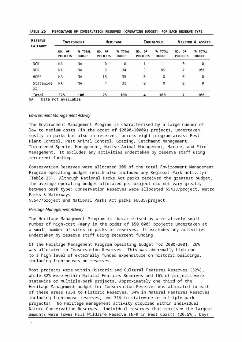
6
RANK PARK NAME PARK ID NO.
PV REGION AND DISTRICT BIOREGION CMA REGION
66 Bronzewing FFR 37 West, Mallee Lowan Mallee Mallee67 Koorangie (The Marshes & Avoca
Floodway) WR* (Ramsar)519 Central, Murray Central Murray Mallee, Victorian Riverina North Central
68 Lake Boga LR 3083 West, Mallee Murray Fans North Central69 Cullens Lake WR 508 Central, Murray Central Victorian Riverina North Central70 Lake Lalbert WR 525 West, Mallee Murray Mallee North Central71 Lake Tutchewop WR 543 Central, Murray Central Victorian Riverina North Central72 Johnson Swamp WR 586 Central, Murray Central Victorian Riverina, Murray Fans North Central73 Hird Swamp WR 583 Central, Murray Central Victorian Riverina North Central74 Lake Heywood WR 524 West, Mallee Murray Mallee, Murray Fans Mallee75 Tragowel Swamp WR 603 Central, Murray Central Victorian Riverina North Central76 Swan Bay – Edwards Point WR* 546 City & Bays, Port Phillip Otway Plain Corangamite77 Gunner's Tank BR 1153 West, Mallee Murray Mallee Mallee78 Torney's Tank BR 1257 West, Mallee Murray Mallee Mallee79 Jilpanger FFR 125 West, Grampians Wimmera Wimmera80 Avon – Mt Hedrick NFSR 2938 East, Alpine Gippsland Plain, Highlands – West Gippsland
Southern Fall81 Cundare Pool (Lake Martin) LR 3143 West, West Coast Victorian Volcanic Plain Corangamite82 Mount Bolangum FFR 196 Central, Murray Central Goldfields North Central83 Stradbroke FFR 275 East, West Gippsland Gippsland Plain West Gippsland84 Lake Burrumbeet LR 3175 West, Grampians Victorian Volcanic Plain Glenelg85 Wilkin FFR 332 West, Grampians Glenelg Plain Glenelg86 Maldon HA* 2636 Central, Murray Central Goldfields North Central87 Lake Gnarpurt LR 3135 West, West Coast Victorian Volcanic Plain Corangamite88 Lough Calvert LR 3147 West, West Coast Victorian Volcanic Plain Corangamite89 Landsborough FFR 153 West, Grampians Goldfields Wimmera90 Mullungdung FFR 212 East, West Gippsland Gippsland Plain West Gippsland91 Narrawong FR 215 West, West Coast Glenelg Plain Glenelg92 Dowd Morass WR* 652 East, East Gippsland Gippsland Plain West Gippsland93 Mount Wombat–Garden Range 208 Central, Central Highlands Central Victorian Uplands Goulburn
FFR94 Reedy Lake, Nagambie WR 638 Central, Murray Central Victorian Riverina Goulburn95 Howqua Hills HA* 2923 East, Alpine Highlands – Northern Fall Goulburn96 Moliagul HA 2637 Central, Murray Central Goldfields North Central97 Glenelg River, Fulham SSR 2532 West, Grampians Dundas Tablelands Glenelg98 Heathcote SR 2725 Central, Murray Central Goldfields North Central99 Lake Omeo LR 3066 East, Alpine Highlands – Northern Fall East Gippsland
100 Lake Beeac WR 418 West, West Coast Victorian Volcanic Plain Corangamite101 North, Centre and other Lakes 753 West, Grampians Wimmera Wimmera
WR102 Mount Murphy HA* 2929 East, Alpine Highlands – Northern Fall, Victorian North East
Alps103 Mount Beckworth SR 2724 West, Grampians Victorian Volcanic Plain, Central North Central
Victorian Uplands104 Lake Boort LR 3084 Central, Murray Central Murray Mallee, Victorian Riverina North Central105 Lake Weeranganuk LR 3134 West, West Coast Victorian Volcanic Plain Corangamite106 Lake Bullen Merri LR 3129 West, West Coast Victorian Volcanic Plain Corangamite107 Lake Bookar WR 419 West, West Coast Victorian Volcanic Plain Glenelg108 Mount Korong SR 2722 Central, Murray Central Goldfields North Central109 Lake Kanagulk WR 736 West, Grampians Wimmera Glenelg110 Stokes River (3) SSR 3212 West, Grampians Glenelg Plain Glenelg
6
RANK PARK NAME PARK ID NO.
PV REGION AND DISTRICT BIOREGION CMA REGION
111 Tooloy FR 299 West, Grampians Glenelg Plain Glenelg112 Kanawinka FR 256 West, Grampians Glenelg Plain Glenelg113 Mount Doboobetic BR 1941 Central, Murray Central Wimmera North Central114 Dumbopperty Swamp & Lake
Bringalbart LR3088 West, Grampians Wimmera Wimmera
115 Mortlake Common FR 3254 West, West Coast Victorian Volcanic Plain Glenelg116 Dowdle Swamp WR 579 Central, Murray Central Victorian Riverina Goulburn117 Macfarlane Lookout NFSR 2916 East, Alpine Highlands – Northern Fall East Gippsland118 Meereek FR 179 West, Grampians Glenelg Plain Wimmera119 Big Reedy Lagoon WR 575 Central, Murray Central Murray Fans Goulburn120 Milangil Lake WR 437 West, West Coast Victorian Volcanic Plain Corangamite121 Deep Lead EA 2713 West, Grampians Goldfields Wimmera122 Victoria Falls HA 2925 East, Alpine Highlands – Northern Fall East Gippsland123 Lake Wongan WR 398 West, Grampians Victorian Volcanic Plain Glenelg124 Seven Creeks WR 649 Central, Central Highlands Central Victorian Uplands, Highlands Goulburn
– Northern Fall125 Brady Swamp WR 376 West, Grampians Victorian Volcanic Plain Glenelg126 Lake Terangpom WR 434 West, West Coast Victorian Volcanic Plain Corangamite127 Gemmill Swamp WR 581 Central, Murray Central Victorian Riverina Goulburn128 Wooroonook Lakes (Middle and 823 Central, Murray Central Murray Mallee, Wimmera North Central
East) WR129 Reef Island and Bass River Mouth 366 City & Bays, Mornington / Gippsland Plain Port Phillip
NCR Wport130 Goulburn River, Yambuna Bridge 2736 Central, Murray Central Murray Fans Goulburn
SSR131 Yambuk FFR 347 West, West Coast Warrnambool Plain Glenelg132 Tabilk Lagoon WR 639 Central, Murray Central Victorian Riverina Goulburn133 Tang Tang Swamp WR 640 Central, Murray Central Victorian Riverina North Central134 Hughes Creek FR 113 Central, Central Highlands Central Victorian Uplands Goulburn135 St. Mary's Lake LR 3102 West, Grampians Wimmera Wimmera136 Jacka Lake & lakes to north WR 715 West, Grampians Wimmera Wimmera137 Tyrendarra FR 309 West, West Coast Victorian Volcanic Plain Glenelg138 Lake Clarke WR 731 West, Grampians Wimmera Wimmera139 Avenel I177 BR 2413 Central, Murray Central Victorian Riverina Goulburn140 Lake Carchap WR 730 West, Grampians Wimmera Wimmera141 Hateleys Lake WR 724 West, Grampians Wimmera Wimmera142 Lake Oundell WR 429 West, Grampians Victorian Volcanic Plain Glenelg143 Pot Brook WR 763 West, Grampians Wimmera Wimmera144 Glenorchy I5 BR 2241 West, Grampians Wimmera Wimmera145 Western Wooroonook LR 3117 Central, Murray Central Murray Mallee, Wimmera North Central146 Mitta Mitta BR 1399 East, Alpine Northern Inland Slopes North East147 Princetown WR 440 West, West Coast Warrnambool Plain Corangamite148 Princetown NCR 3785 West, West Coast Warrnambool Plain Corangamite149 Mud Islands WR 559 City & Bays, Port Phillip Port Phillip150 Hotspur BR 1973 West, West Coast Glenelg Plain Glenelg151 Brodribb River FFR 36 East, East Gippsland East Gippsland Lowlands East Gippsland152 Nelson SSR 2541 West, West Coast Glenelg Plain, Bridgewater Glenelg153 Illawarra I59 BR 2478 West, Grampians Wimmera, Goldfields Wimmera154 Lake Werowrap LR 3165 West, West Coast Victorian Volcanic Plain Corangamite155 Lake Tim Dunn LR 3069 West, Grampians Dundas Tablelands Glenelg156 Gampola I7 BR 2243 West, Grampians Goldfields Wimmera
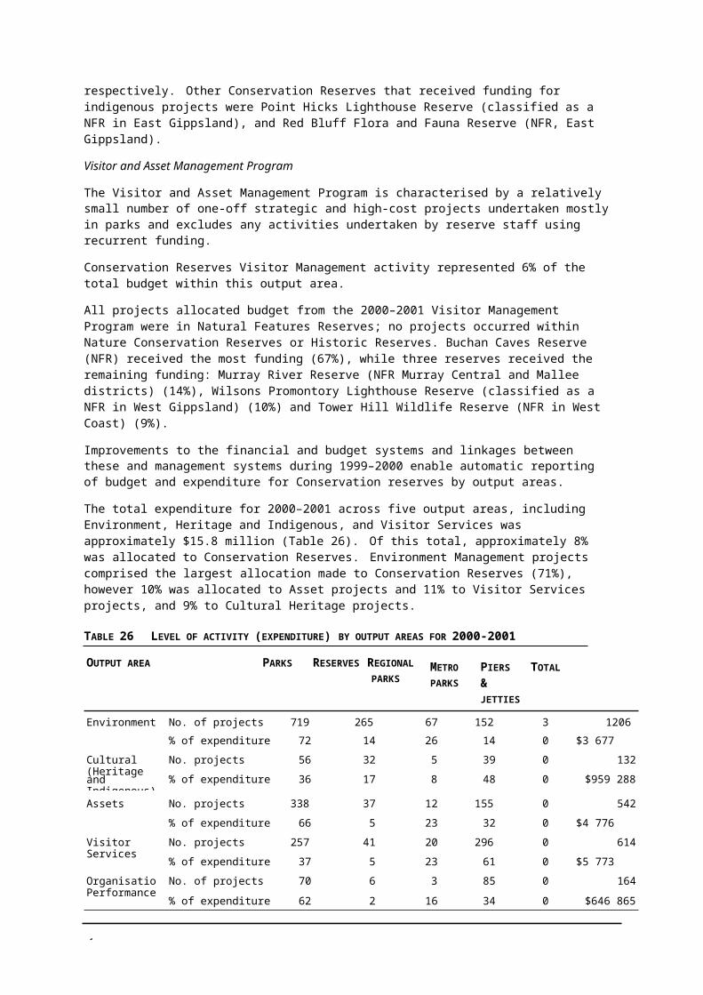
6
RANK PARK NAME PARK ID NO.
PV REGION AND DISTRICT BIOREGION CMA REGION
157 Waggarandall BR 2051 Central, Murray Central Victorian Riverina Goulburn158 Broadwater I91 BR 2510 West, West Coast Warrnambool Plain Glenelg159 Lake Bolac HP 3202 West, Grampians Victorian Volcanic Plain Glenelg160 Warrengine Creek SSR 2773 City & Bays, Mornington /
WportGippsland Plain Port Phillip (& off Vic
coast)161 Woodnaggerak BR 2215 West, Grampians Victorian Volcanic Plain, Central Glenelg
Victorian Uplands162 Mount Wills HA* 2928 East, Alpine Highlands – Northern Fall, Victorian North East
Alps163 Cassilis HA 2927 East, Alpine East Gippsland Uplands, Highlands East Gippsland
– Southern Fall, Highlands –Northern Fall, Victorian Alps
164 Mount Tambo NFSR 2917 East, Alpine East Gippsland Uplands, Highlands East Gippsland– Northern Fall
165 Mount Elizabeth NFSR 2939 East, East Gippsland East Gippsland Uplands East Gippsland166 Mount Black FR 195 Central, Murray Central Goldfields Goulburn167 Tomahawk Creek BR 1043 West, West Coast Otway Plain, Warrnambool Plain Corangamite168 Olangolah FFR 229 West, West Coast Otway Ranges Corangamite169 Dalyenong (1) FR 57 Central, Murray Central Goldfields North Central170 Mount Gibbo NFSR 2915 East, Alpine Victorian Alps North East171 Wiridjil BR 1044 West, West Coast Otway Plain Corangamite172 Carpendeit FFR 50 West, West Coast Warrnambool Plain Corangamite173 Barrabool FFR 14 West, Grampians Wimmera Wimmera174 Tarnagulla FR 280 Central, Murray Central Goldfields North Central175 Anglesea FR 3 West, West Coast Otway Plain Corangamite176 Murrindindi River NFSR 2900 Central, Central Highlands Highlands – Northern Fall Goulburn177 Bryan Swamp WR 713 West, Grampians Victorian Volcanic Plain Glenelg178 Mount Bullfight NCR 197 Central, Central Highlands Victorian Alps Goulburn179 Lake Purrumbete WR 430 West, West Coast Victorian Volcanic Plain Corangamite180 Woolshed Swamp, Boort WR 608 Central, Murray Central Victorian Riverina North Central181 Glenelg River (8) SSR 3219 West, Grampians Glenelg Plain, Dundas Tablelands Glenelg182 Yellingbo NCR* 360 Central, Central Highlands Highlands – Southern Fall Port Phillip183 Lake Weering LR 3145 West, West Coast Victorian Volcanic Plain Corangamite184 Whroo HA 2639 Central, Murray Central Goldfields Goulburn185 Lake Thurrumbong LR 436 West, West Coast Victorian Volcanic Plain Corangamite186 Heart Morass WR* 3637 East, East Gippsland Gippsland Plain West Gippsland187 Rowan Swamp WR 600 Central, Murray Central Victorian Riverina Goulburn188 Lake Muirhead WR 740 West, Grampians Dundas Tablelands Glenelg189 Gobarup FR 97 Central, Murray Central Goldfields Goulburn190 Little Bog Creek FFR 162 East, East Gippsland East Gippsland Uplands, Monaro East Gippsland
Tablelands191 Sale Common WR* 3667 East, East Gippsland Gippsland Plain West Gippsland192 Buchan Caves Reserve 2950 East, East Gippsland East Gippsland Uplands East Gippsland193 Mount Delegate SR 2968 East, East Gippsland Monaro Tablelands East Gippsland194 Doctors Swamp WR 613 Central, Murray Central Victorian Riverina Goulburn195 Lake Moodemere LR 3085 Central, Murray Central Victorian Riverina North East196 Darlot Swamp WMCA* 796 West, Grampians Wimmera Wimmera197 Boweya FFR 32 Central, Murray Central Northern Inland Slopes Goulburn198 Mount Erip FR 200 West, Grampians Central Victorian Uplands Corangamite199 Lake Condah WR 695 West, West Coast Victorian Volcanic Plain Glenelg200 Kerr Swamp WR 694 West, Grampians Glenelg Plain Glenelg201 Leah Swamp WR 743 West, Grampians Wimmera Wimmera

6
RANK PARK NAME PARK ID NO.
PV REGION AND DISTRICT BIOREGION CMA REGION
202 Ovens River FR 240 Central, Murray Central Victorian Riverina North East203 Lake Buninjon WR 729 West, Grampians Victorian Volcanic Plain Glenelg204 Huntly SSR 2693 Central, Murray Central Victorian Riverina, Goldfields North Central205 Morrl Morrl FR 192 West, Grampians Goldfields North Central206 Moodie Swamp WR 592 Central, Murray Central Victorian Riverina, Northern Inland Goulburn
Slopes207 Lonsdale Lakes WR 556 City & Bays, Port Phillip Otway Plain Corangamite208 Goulburn River K50 SSR 2668 Central, Murray Central Victorian Riverina Goulburn209 Lake Terrinallum WR 435 West, Grampians Victorian Volcanic Plain Glenelg210 Latrobe I11 BR 1051 West, West Coast Warrnambool Plain Corangamite211 Connangorach Swamp WR 718 West, Grampians Wimmera Wimmera212 Tooan BR 2453 West, Grampians Wimmera Wimmera213 Haddon Common BR 2225 West, Grampians Victorian Volcanic Plain Corangamite214 Sheepwash, Charam WR 767 West, Grampians Wimmera Wimmera215 Clear Lake LR 3103 West, Grampians Wimmera Wimmera216 Jeeralang North EA 2987 East, West Gippsland Gippsland Plain, Strzelecki Ranges West Gippsland217 Mount Mitta Mitta FR 206 East, Alpine Northern Inland Slopes North East218 Miga Lake LR 3097 West, Grampians Wimmera Wimmera219 Derrimut Grasslands NCR* 4008 Central, Basalt Plains Victorian Volcanic Plain Port Phillip220 Bates Lake HP 3182 West, Grampians Wimmera Wimmera221 Kaladbro H3 BR 1022 West, Grampians Glenelg Plain Glenelg222 Glenelg River (5) SSR 3216 West, Grampians Glenelg Plain Glenelg223 Tungamah Swamp WR 604 Central, Murray Central Victorian Riverina Goulburn224 Jubilee Swamp WR 587 Central, Murray Central Victorian Riverina Goulburn225 Sparrowhawk Gully I156 BR 2392 Central, Murray Central Goldfields North Central226 Moyston FR 209 West, Grampians Central Victorian Uplands Wimmera227 Lang Lang EA 2852 East, West Gippsland Gippsland Plain Port Phillip228 Wimmera River, Marma SSR 2522 West, Grampians Wimmera Wimmera229 Mount Ridley Grassland NCR 4009 Central, Basalt Plains Victorian Volcanic Plain Port Phillip230 Jones Bay WR 3655 East, East Gippsland Gippsland Plain East Gippsland231 Lake Terang LR 3128 West, West Coast Victorian Volcanic Plain Glenelg232 Fosterville HA 2652 Central, Murray Central Goldfields North Central233 Boosey Creek SSR 2744 Central, Murray Central Victorian Riverina Goulburn234 Morea I4 BR 2423 West, Grampians Wimmera Wimmera235 Wash Tomorrow (Washdamorra)
Swamp WR776 West, Grampians Dundas Tablelands Wimmera
236 Lake Crawford WR 696 West, West Coast Glenelg Plain, Victorian Volcanic GlenelgPlain
237 McCosslen Swamp WR 749 West, Grampians Wimmera Wimmera238 Howell's Hill SR 2517 Central, Murray Central Goldfields North Central239 Breamlea FFR 33 City & Bays, Port Phillip Victorian Volcanic Plain Corangamite240 Floating Islands FFR* 408 West, West Coast Victorian Volcanic Plain Corangamite241 Lake Koynock WR 739 West, Grampians Wimmera Wimmera242 Waaia SSR 2741 Central, Murray Central Victorian Riverina Goulburn243 Mumbannar BR 1027 West, West Coast Glenelg Plain Glenelg244 Balmattum Hill BR 1039 Central, Central Highlands Victorian Riverina Goulburn245 Corack East I141 BR 1931 Central, Murray Central Murray Mallee North Central246 Yering Gorge BR 1601 Melbourne Metro, Yarra Highlands – Southern Fall Port Phillip247 Beeac Swamp LR 3153 West, West Coast Victorian Volcanic Plain Corangamite248 Lehmann Swamp WR 589 Central, Murray Central Northern Inland Slopes Goulburn
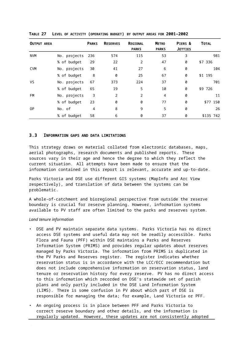
6
RANK PARK NAME PARK ID NO.
PV REGION AND DISTRICT BIOREGION CMA REGION
249 Bungalally I50 BR 2469 West, Grampians Wimmera Wimmera250 Jindivick G77 BR 1618 Melbourne Metro,
DandenongsGippsland Plain Port Phillip
251 Donald (Dollin) Swamp WR 721 West, Grampians Wimmera Wimmera252 Mangalore FR 171 Central, Murray Central Victorian Riverina Goulburn253 Gresswell Forest NCR 105 Melbourne Metro, Yarra Gippsland Plain Port Phillip254 Drumborg BR 1032 West, West Coast Victorian Volcanic Plain Glenelg255 Devils Kitchen GR 2574 West, Grampians Victorian Volcanic Plain, Central
Victorian UplandsCorangamite
256 Red Rock BR 2465 West, Grampians Dundas Tablelands Wimmera257 Dereel Lagoon WR 395 West, Grampians Central Victorian Uplands Corangamite258 Victoria Lagoon WR* 773 West, Grampians Dundas Tablelands Glenelg259 Tharanbegga H46 BR 2053 Central, Murray Central Victorian Riverina Goulburn260 Reilly's Creek WR 2444 West, Grampians Wimmera Glenelg261 Lake Charlegrark LR 3090 West, Grampians Wimmera Wimmera262 Wannon Falls SR 2529 West, Grampians Dundas Tablelands Glenelg263 Bungalally I49 BR 2468 West, Grampians Wimmera Wimmera264 Mount Martha NCR 362 City & Bays, Mornington /
WportGippsland Plain Port Phillip
265 Red Hill Swamp WR 700 West, Grampians Glenelg Plain Glenelg266 Gooram Gooram Gong I47 BR 1411 Central, Central Highlands Central Victorian Uplands Goulburn267 Yalong South H3 BR 2211 West, Grampians Goldfields North Central268 Byron's Swamp LR 3098 West, Grampians Wimmera Wimmera269 Jung Jung Swamp BR 1882 West, Grampians Wimmera Wimmera270 Chesney Vale Hills H97 BR 2104 Central, Murray Central Northern Inland Slopes Goulburn271 Nalangil LR 3168 West, West Coast Victorian Volcanic Plain Corangamite272 Brig Brig Swamp WR 711 West, Grampians Wimmera Wimmera273 Marong I147 BR 2383 Central, Murray Central Victorian Riverina North Central274 Bald Hills FR 337 East, West Gippsland Strzelecki Ranges West Gippsland275 Mount Bute SR 2579 West, Grampians Central Victorian Uplands Corangamite276 Victoria Star Mine HA 2972 East, East Gippsland Monaro Tablelands East Gippsland277 Lake Sinclair WR 697 West, West Coast Victorian Volcanic Plain Glenelg278 Red Cap Creek SSR 2546 West, Grampians Dundas Tablelands Glenelg279 Lake Barnie Buloke WR 417 West, West Coast Victorian Volcanic Plain Glenelg280 Casey's Weir HP 3204 Central, Murray Central Northern Inland Slopes Goulburn281 Lake Coragulac LR 3164 West, West Coast Victorian Volcanic Plain Corangamite282 Wises Creek FR 335 East, Alpine Northern Inland Slopes North East283 Lake Cartcarrong LR 3078 West, West Coast Victorian Volcanic Plain Glenelg284 Beaufort H11 BR 2219 West, Grampians Victorian Volcanic Plain Glenelg
Central Victorian Uplands285 Charlegrark Swamp WR 717 West, Grampians Wimmera Wimmera286 Illawarra I60 BR 2479 West, Grampians Wimmera, Goldfields Wimmera287 Mount Talbot SR 2523 West, Grampians Dundas Tablelands Wimmera288 Lake Gillear WR 424 West, West Coast Warrnambool Plain Glenelg289 Tarago River, Robin Hood SSR 2786 East, West Gippsland Gippsland Plain Port Phillip290 Bolwarra H45 BR 1984 West, West Coast Victorian Volcanic Plain Glenelg291 Lake Aringa WR 415 West, West Coast Victorian Volcanic Plain Glenelg292 Hopkins River, Wickliffe SSR 2592 West, Grampians Victorian Volcanic Plain, Dundas
TablelandsGlenelg
293 Gooram Gooram Gong I46 BR 1410 Central, Central Highlands Central Victorian Uplands Goulburn294 Digby H5 BR 1024 West, West Coast Dundas Tablelands Glenelg

6
RANK PARK NAME PARK ID NO.
PV REGION AND DISTRICT BIOREGION CMA REGION
295 Glenelg River J4 SSR 2542 West, Grampians Dundas Tablelands Glenelg296 St Arnaud Gold Mining Company
dam HA3723 Central, Murray Central Goldfields North Central
297 Murchison Waterworks Trust HA 2658 Central, Murray Central Victorian Riverina Goulburn298 Pyramid Hill BR 2013 Central, Murray Central Victorian Riverina North Central299 Marengo FR 147 West, West Coast Otway Ranges Corangamite300 Spadoni's NCR 267 Melbourne Metro, Yarra Highlands – Southern Fall Port Phillip301 Nigretta Falls FR 298 West, Grampians Dundas Tablelands Glenelg302 Lake Kornong WR 427 West, Grampians Victorian Volcanic Plain Glenelg303 Raglan BR 2216 West, Grampians Central Victorian Uplands Glenelg304 Kanawinka H16 BR 1955 West, Grampians Glenelg Plain Glenelg305 Wareek I90 BR 2326 West, Grampians Victorian Volcanic Plain North Central306 Yatmerone Swamp WR 454 West, West Coast Victorian Volcanic Plain Glenelg307 Glenorchy SSR 2705 West, Grampians Wimmera Wimmera308 Cranbourne Wetlands NCR 4005 City & Bays, Mornington /
WportGippsland Plain Port Phillip
309 Naringaningalook H32 BR 2039 Central, Murray Central Victorian Riverina Goulburn310 Killawarra H107 BR 2114 Central, Murray Central Victorian Riverina North East311 Beaufort H10 BR 2218 West, Grampians Central Victorian Uplands Glenelg312 Kout Narin I37 BR 2456 West, Grampians Dundas Tablelands Glenelg313 Clarke Road SSR 2815 Central, Basalt Plains Victorian Volcanic Plain Port Phillip314 Sandy Creek, Elmhurst SSR 2581 West, Grampians Central Victorian Uplands Wimmera315 Port Fairy maritime complex HA 3718 West, West Coast Warrnambool Plain Glenelg (& off Vic
coast)316 Everard Park SSR 2770 Central, Central Highlands Highlands – Southern Fall Port Phillip317 Barwo H19A BR 2134 Central, Murray Central Murray Fans Goulburn318 White's Lake LR 3072 West, Grampians Dundas Tablelands Glenelg319 Murchison WR 391 Central, Murray Central Victorian Riverina Goulburn320 Nungurner BR 2207 East, East Gippsland Gippsland Plain East Gippsland321 Broadwater I90 BR 2509 West, West Coast Warrnambool Plain Glenelg322 Moranding I23 BR 1493 Central, Basalt Plains Central Victorian Uplands Goulburn323 Molka H67 BR 2074 Central, Murray Central Victorian Riverina Goulburn324 Gowangardie FR 102 Central, Murray Central Northern Inland Slopes Goulburn325 Lake Buloke WMCA* 1789 Central, Murray Central Murray Mallee North Central326 Wathe FFR 326 West, Mallee Lowan Mallee Mallee327 Red Bluff FFR 253 West, Mallee Lowan Mallee Mallee328 Birdcage FFR 23 West, Mallee Lowan Mallee Mallee329 Lake Wahpool LR 3120 West, Mallee Murray Mallee Mallee330 Lake Timboram FFR 150 West, Mallee Murray Mallee Mallee331 Timberoo 291 West, Mallee Murray Mallee Mallee332 Wandella FFR 321 Central, Murray Central Victorian Riverina North Central333 Mullroo Creek WR 535 West, Mallee Murray Scroll Belt Mallee334 Lambert Island FR 152 West, Mallee Robinvale Plains Mallee335 Lakes Coorong & Lascelles LR 3064 West, Mallee Murray Mallee Mallee336 Mitre Lake FFR 186 West, Grampians Wimmera Wimmera337 Dartagook WR 509 Central, Murray Central Victorian Riverina North Central338 Lake Wyn Wyn WR 807 West, Grampians Wimmera Wimmera339 Lakes Powell and Carpul WR 532 West, Mallee Murray Mallee Robinvale Plains Mallee340 Bumbang Island HA 2606 West, Mallee Robinvale Plains Mallee341 Booroopki Swamp LR 3089 West, Grampians Wimmera Wimmera
6
RANK PARK NAME PARK ID NO.
PV REGION AND DISTRICT BIOREGION CMA REGION
342 Oliver's Lake FFR 230 West, Grampians Wimmera Wimmera343 Yassom Swamp FFR 354 Central, Murray Central Victorian Riverina North Central344 Baillieu (Richardsons) Lagoon 574 Central, Murray Central Murray Fans North Central
WR345 Brimy Bill (5 Mile Lake) WR 506 West, Mallee Murray Mallee Mallee346 Tutye BR 1123 West, Mallee Murray Mallee Mallee347 Barrett FFR 15 West, Grampians Wimmera Wimmera348 McDonald Swamp WR 591 Central, Murray Central Murray Fans North Central349 Cemetery Forest WR 578 Central, Murray Central Victorian Riverina, Murray Fans North Central350 Dooen Swamp BR 1880 West, Grampians Wimmera Wimmera351 Woodside H28 BR 2165 East, West Gippsland Gippsland Plain West Gippsland352 Boinka FR 26 West, Mallee Murray Mallee Mallee353 Mamengoroock I72 BR 1126 West, Mallee Murray Mallee Mallee354 Meringur FR 169 West, Mallee Murray Mallee Mallee355 Mount Hope FFR 210 Central, Murray Central Northern Inland Slopes North Central356 Lake Elizabeth WR 522 Central, Murray Central Victorian Riverina North Central357 Hardings Swamp (Tarranginnie
Swamp) WR802 West, Grampians Wimmera Wimmera
358 Degraves Tank FR 64 West, Mallee Murray Mallee Mallee359 Loch Iel (Pink Lake) LR 3115 West, Grampians Murray Mallee Wimmera360 Yarrackigarra Swamp WR 825 West, Grampians Wimmera Wimmera361 Tcham Lakes LR 3065 West, Mallee Murray Mallee Mallee362 Patho WR 596 Central, Murray Central Murray Fans North Central363 Warracknabeal SSR 2520 West, Grampians Wimmera Wimmera364 Kiata FFR 140 West, Grampians Wimmera Wimmera365 McClure BR 1864 West, Grampians Wimmera Wimmera366 Lake Mannaor WR 527 West, Mallee Victorian Riverina, Murray Fans North Central367 Mooree HA 2608 West, Grampians Lowan Mallee, Wimmera Wimmera368 Morkala BR 1278 West, Mallee Murray Mallee Mallee369 Gerang Gerung (south) FR 87 West, Grampians Wimmera Wimmera370 Green Swamp WR 799 West, Grampians Wimmera Wimmera371 Telfer's Swamp (Parker Swamp) 284 West, Grampians Wimmera Wimmera
FFR372 Jane Duff HP 3180 West, Grampians Wimmera Wimmera373 Murrayville BR 1297 West, Mallee Murray Mallee Mallee374 Leaghur BR 1272 Central, Murray Central Murray Mallee North Central375 Dimboola FR 66 West, Grampians Wimmera Wimmera376 Tyrrell Creek SSR 2513 West, Mallee Murray Mallee Mallee377 Major Mitchell Lagoon HA 2605 West, Mallee Murray Fans Mallee378 Bruthen FR 39 East, West Gippsland Gippsland Plain West Gippsland379 Ninyeunook I205 BR 1266 Central, Murray Central Victorian Riverina North Central
700BASALT PLAINS
600
500
400
300
200
100 7217 1 0
0
387
Nat
ural
Fea
ture
s R
eser
ves
110 23
tion
l
erva
serv
e
erve
Con
s
& C
s
Re
Res
ture
se
rv
toric
asta
l
Na
Re
His
Fe C
o
307
602 0
608
33 0
WEST COAST700
600
500
400
300
200
100
144
443 7
0
Num
ber o
f
e
ua
s s
1
0
0
Map 1 Number ofConservation Reserves
700
600
500
400
300
200
100
0
MALLEE700
600
500
400
300
200
100
0
BASALT PLAINS
7217 1 0
700
600
500
400
300
200
100
0
MURRAY CENTRAL
533
6939 0
700
600
500
400
300
200
100
0
CENTRAL HIGHLANDS
124
24 6 0
2400
2000
1600
1200
800
400
0
TOTAL IN VICTORIA2174
Reserve Category
Parks Victoria Region
Boundaries Parks Victoria
District Boundaries Victoria
700ALPINE
700
600
500
400
300
200
100
0
GRAMPIANS
71
West
CCennttral
600
500
400
300
200
100
0
788 12 0
East
Melbouournnneeee Metropopolitan
700EAST GIPPSLAND
CCCCity & BBays
700
600
500
400
DANDENONGS600
500
400
300
200
700
600
500
400
PORT PHILLIP
MORNINGTON / EAST METROPOLITAN
300
200
100
02
34 0
0
100
0
6524 3 3
300
200
1008 7 5
0
700
600
500
400
300
200
100CITY &
WATERWAYS
600
500
400
300
200
100
WESTERNPO
RT 700
600
500
400
300
200
100 700
600
500
400
300
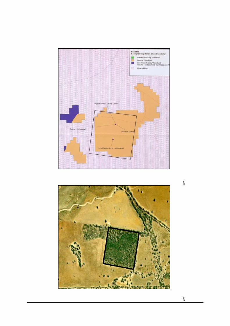
0
6
200
100
YARRA
700
600
500
400
300
200
100WEST GIPP
SLAND
136 0 37.5 75
00 0 0 0
10 25 2 4 3 19 0 0 9 22 1 0 38 7
40
kilometres

No Window
No Window No Window No Window
No Window
153612 273431 40403 15257
Nat
ural
Fea
ture
s R
eser
ves
tion
l s
erva
serv
erve
Nat
ure
Con
s R
eser
ves &
C
s R
e
Res
a ture
a
H F e C
isto
ricul
tura
es
o
6741 5959856 0
60381
24031
2382 0
Are
a
0
Map 2 Area ofConservation Reserves
100000
80000
60000
40000
MALLEE
85838
56881
100000
80000
60000
40000
20000
BASALT PLAINS100000
80000
60000
40000
20000
MURRAY CENTRAL
33332
23541
100000
80000
60000
40000
20000
CENTRAL HIGHLANDS
250000
200000
150000
100000
TOTAL IN VICTORIA
20000
0652 0
2837 1343
00
9450
00
0
50000
0Reserve Category
Parks Victoria Region
Boundaries Parks Victoria District
Boundaries Victoria
100000
80000
60000
40000
20000
0
GRAMPIANS
West
CCennttral
100000
80000
60000
40000
20000
0
ALPINE
2333018789
600 0
East
100000
80000
60000
40000 CCCCity &
Melbouournnneeee Metropopolliiitan 100000 100000
20000
0
1391926871
227072
100000
80000
PORT PHILLIP
BBays
80000
60000
40000
20000
0322
750 00
80000
60000
40000
20000
0
10589
22916
120
1213
60000
40000
20000
0 1131 3855 0 4317
100000
80000
60000
40000
20000 CITY & WATERWAYS
100000
80000
60000
40000
20000
MORNINGTON / WESTERNPORT 100000
80000
60000
40000
20000 EAST METROPOLITAN
100000
80000
60000
40000
20000
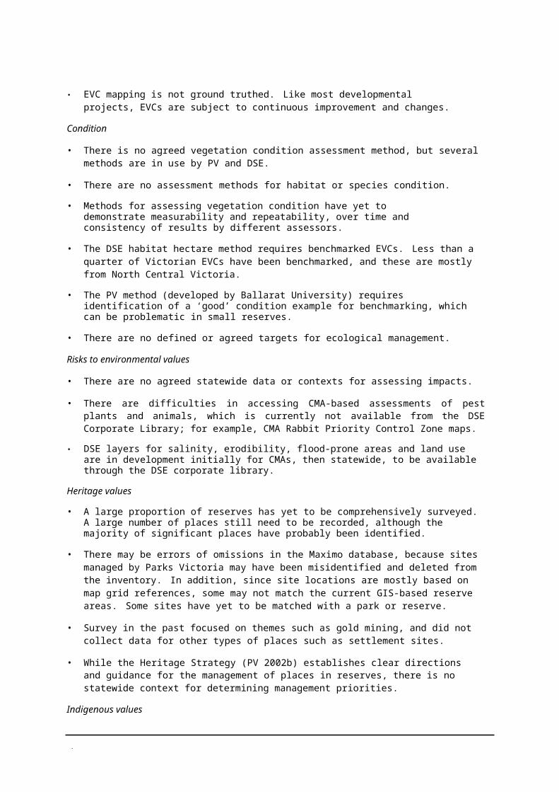
No Window
No Window No Window
No Window
0
YARRA 100000
80000
60000
40000
20000
0WEST
GIPPSLA
ND13358
9743
3712 2655 0 37.5 75
kilometres
00 0 0 0 1958
0244 141 1089 131 206 0
0 01282 282 0 0