Embed Size (px)
Citation preview
Rio Tinto
Greater West Angelas Vegetation and Flora Assessment
April 2013
54
Conservation Status
Taxon Family No. of records in Study Area
Habitat (WA Herbarium 2012)
Distribution Flower Period
Picture
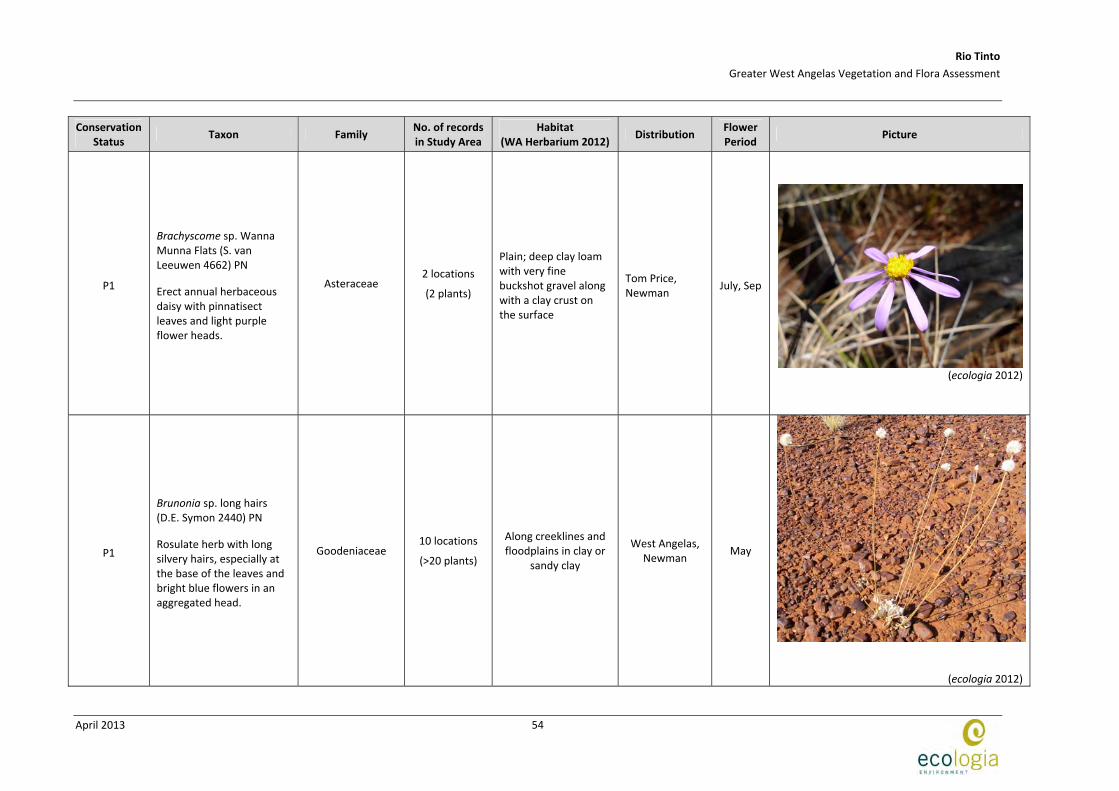
P1
Brachyscome sp. Wanna Munna Flats (S. van Leeuwen 4662) PN
Erect annual herbaceous daisy with pinnatisect leaves and light purple flower heads.
Asteraceae 2 locations
(2 plants)
Plain; deep clay loam with very fine buckshot gravel along with a clay crust on the surface
Tom Price, Newman
July, Sep
(ecologia 2012)
P1
Brunonia sp. long hairs (D.E. Symon 2440) PN
Rosulate herb with long silvery hairs, especially at the base of the leaves and bright blue flowers in an aggregated head.
Goodeniaceae 10 locations
(>20 plants)
Along creeklines and floodplains in clay or
sandy clay
West Angelas, Newman
May
(ecologia 2012)

Rio Tinto
Greater West Angelas Vegetation and Flora Assessment
April 2013
55
Conservation Status
Taxon Family No. of records in Study Area
Habitat (WA Herbarium 2012)
Distribution Flower Period
Picture
P2
Aristida lazaridis
A tufted perennial grass. Leaf‐blade surface scaberulous; rough on both sides.
Poaceae 3 locations
(>23 plants) Sand or loam
Karijini N.P., Queensland
Apr
(Western Australia Herbarium 2012)
P2
Eremophila forrestii subsp. Pingandy (M.E. Trudgen 2662)
Shrub to 50 cm tall, compact tight bush. Flowers pale yellow‐cream to pinky‐yellow.
Scrophulariaceae 1 location
(1 plant)
Flat terrain, low in landscape, base of broad valley, stony gibber plain above
shallow drainage line, red clay‐loam.
West Angela Hill, Karijini
National Park, Turee Creek Homestead
Jun
(ecologia 2012)

Rio Tinto
Greater West Angelas Vegetation and Flora Assessment
April 2013
56
Conservation Status
Taxon Family No. of records in Study Area
Habitat (WA Herbarium 2012)
Distribution Flower Period
Picture
P3
Acacia aff. subtiliformis
Erect, spindly, wispy, single‐stemmed, glabrous shrubs, the upper branches scarred where phyllodes have fallen.
Fabaceae 3 locations
(~250 plants)
On rocky calcrete plateaus
Hamersley Ranges, Hancock Range, Ophthalmia Range, Hope Down North, Marillana Stn
Jul, Aug
(ecologia 2012)
P3
Indigofera sp. Gilesii (M.E. Trudgen 15869) An open shrub, to 1.5 m high with purple‐pink flowers.
Fabaceae 24 locations
(>232 plants)
Pebbly loam amongst boulders & outcrops.
Hills
Mt Ella, Newman,
Rhodes Ridge, Coondewanna
and West Angelas Hill
May or Aug
(ecologia 2012)

Rio Tinto
Greater West Angelas Vegetation and Flora Assessment
April 2013
57
Conservation Status
Taxon Family No. of records in Study Area
Habitat (WA Herbarium 2012)
Distribution Flower Period
Picture
P3
Rhagodia sp. Hamersley (M. Trudgen 17794) Small erect, open shrub or scrambler to 4 m high with green ‐ cream flowers.
Chenopodiaceae 31 locations
(>81 plants)
Gravely silt and sand in sheet‐flood fans. Red brown silty clay loam / silty loam on undulating plains.
Tom Price, Paraburdoo,
Brockman and Newman
May
(ecologia 2012)
P3
Sida sp. Barlee Range (S. van Leeuwen 1642) PN
Rounded, densely woolly to velvety somewhat woody shrub, with small ovate ruminate leaves and yellow flowers.
Malvaceae 8 locations
(>42 plants)
Skeletal red soils pockets. Steep slope.
Barlee Range, Turee Creek, Paraburdoo, Hamersley Range
Aug
(ecologia 2012)

Rio Tinto
Greater West Angelas Vegetation and Flora Assessment
April 2013
58
Conservation Status
Taxon Family No. of records in Study Area
Habitat (WA Herbarium 2012)
Distribution Flower Period
Picture
P3
Themeda sp. Hamersley Station (M.E. Trudgen 11431) PN
A robust Kangaroo Grass, tall, with a bluish tinge to tussock.
Poaceae 7 locations
(>3505 plants)
Red clay. Clay pan, grass plain
Karratha, Millstream, Hamersley Stn, West Angelas, Coondewanna Flats
Aug
(ecologia 2012)
P3
Triodia sp. Mt Ella (M.E. Trudgen 12739)
A diffuse, loose, sprawling rather than rounded, hummock hard spinifex grass, leaves bright mid‐green, shiny, very resinous with a distinctive resinous smell.
Poaceae 8 locations
(>300 plants)
Rangeland. Hillside and hill top. Brown/red ironstone gravel
Yarraloola Stn, Yalleen Stn., Red Hill Stn., Mt Stuart Stn., Hamersley Range
‐
(ecologia 2012)

Rio Tinto
Greater West Angelas Vegetation and Flora Assessment
April 2013
59
Conservation Status
Taxon Family No. of records in Study Area
Habitat (WA Herbarium 2012)
Distribution Flower Period
Picture
P4
Goodenia nuda
An erect herb with yellow flowers with a maroon centre.
Goodeniaceae 2 location
(2 plants)
Dry brown‐red sand – loam occasionally in
areas of recent burns.
Port Headland, Newman, Onslow,
Paraburdoo and Tom Price
Apr to Aug
(ecologia 2011)

EEE
E
E
EEE
D D D
D
D
D
D
E
EE EEEE
!(
!(!(
!(
!(!(!(!(
!(
!(!(!(!(
!(
!(!(
!(
!(!(!(!(!(!(!(!(
!(
!(
!(!(!(!(
!(
!(
!(
!(
!(!(!(!(
!(!(!(!(
!(
!(
!(!(!(
!(
!(!(!(!(!(
!(!(!(!(
")")
")
")
")
")
")
")
")
")")
")
")
)
)
E
E
D
D
D
D
D
D
D
D
D DD
D
D
D
D
DD DD
DDD
D
DDD
D
DD
D
DD
D
D DDDD
DD
D
D
D
D
"
"
))))""""
670000 680000 6900007
43
00
00
74
40
00
0
LegendStudy Area
Threatened and Priority Flora") Lepidium catapycnon (T)
D Aristida jerichoensis var. subspinulifera (P1)
") Brachyscome sp. Wanna Munna Flats (S. van Leeuwen 4662) (P1)
") Brunonia sp. long hairs (D.E. Symon 2440) (P1)
") Aristida lazaridis (P2)
!( Eremophila forrestii subsp. Pingandy (M.E. Trudgen 2662) (P2)
!( Acacia aff. subtiliformis (P3)
!( Indigofera gilesii subsp. gilesii (P3)
!( Rhagodia sp. Hamersley (M. Trudgen 17794) (P3
E Sida sp. Barlee Range (S. van Leeuwen 1642) (P3)
D Themeda sp. Hamersley Station (M.E. Trudgen 11431) (P3)
E Triodia sp. Mt Ella (M.E. Trudgen 12739) (P3)
E Goodenia nuda (P4)
Coordinate SystemName: GDA 1994 MGA Zone 50Projection: Transverse MercatorDatum: GDA 1994 A4
Figure: 4.2Project ID: 1457
Drawn: CPDate: 16/10/2012
K0 2 4
Kilometres1:120,000Absolute Scale -
Unique Map ID: CP148Threatened and Priority Flora of the Greater West Angelas
Study Area

Rio Tinto
Greater West Angelas Vegetation and Flora Assessment
April 2013
61
4.2.4 Range Extensions Recorded in the Study Area
The extensions of the known range of distribution for flora recorded in the Study Area have been subdivided into three categories:
Bioregional Extensions: the taxon has not been previously recorded in the IBRA Bioregion in which the Study Area is located;
Range Extension: the records in this study are at least 100 km from the boundary of distribution based on lodged records; and
Bridging Record: a record lying between widely separated populations.
Based on collection records lodged at the WA Herbarium (Western Australian Herbarium 1998‐2013), records from the current survey include one bioregional extension, Maireana lanosa, although only 44 km north of the known population. Records of two taxa represent range extensions; Corymbia zygophylla and Euphorbia schultzii (Table 4.4). Threatened and Priority Flora Report Forms have been completed for these taxa ready for lodgement and can be found in Appendix F
One additional species, Yakirra australiensis var. australiensis has been determined to be a bridging record, as itscollection point was at least 250 km from any other known location.
Table 4.4 – Collections in the Survey Area that Increase the Known Distribution of its Taxa
Taxon Type of record Notes ecologia location
s
WAHERB location
s
Maireana lanosa Bioregional Extension
44 km N of known population First record of the species in the Pilbara Bioregion
1 28
Corymbia zygophylla Range Extension
210 km S of northern population and 300 km E of western population in the Pilbara
1 97
Euphorbia schultzii Range Extension
102 km SE of known population 2 50
Yakirra australiensis var. australiensis
Bridging Record 264 km SE of Pilbara population and 700 km W of eastern record
1 9

Rio Tinto
Greater West Angelas Vegetation and Flora Assessment
April 2013
62
4.3 INTRODUCED FLORA
4.3.1 Weeds of National Significance (WONS)
At a national level there are twenty introduced flora species listed as Weeds of National Significance (WONS). The Commonwealth National Weeds Strategy: A Strategic Approach to Weed Problems of National Significance (2012) describes broad goals and objectives to manage these species. Of these species, eight are currently recorded within the Pilbara (Mesquite, Prosopis spp.; Athel Pine, Tamarix aphylla; Common prickly pear, Opuntia stricta; Parthenium hysterophorus; Prosopis glandulosa x velutina; Mesquite, Prosopis pallida; Salvinia, Salvinia molesta; Athel tree, Tamarix aphylla; and Parkinsonia, Parkinsonia aculeata) but are not known from the Study Area.
No Weeds of National Significance were recorded in the Study Area.
4.3.2 Declared Plants
Weeds that are, or have the potential to become, pests to agriculture can be declared formally under the Agriculture and Related Resources Protection Act 1976 (ARRP Act Department of Agriculture and Food 1976) as Declared Plants. Weeds listed under this Act are listed with Standard Control Codes that outline the requirements for their control. Five priority groupings exist (P1, P2, P3, P4 or P5) and more than one priority may be assigned to a weed species. Different priority levels apply to different municipal districts . Details of these codes are included in Appendix G. Landholders having Declared Plants on their property are obliged to control them at their own expense, and are encouraged to follow the standard control codes.
No Declared Plants were recorded by ecologia in the West Angelas Study Area.
4.3.3 Environmental Weeds
A third and much more extensive categorisation of weeds has been developed by the DEC, formerly the Department of Conservation and Land Management (CALM) in the Environmental Weed Strategy for Western Australia (Department of Conservation and Land Management 1999). Weed species considered to adversely affect the communities they invade are evaluated based on the degree of invasiveness, distribution and environmental impacts. Weeds listed as Environmental Weeds are ranked into four categories using the above criteria and the scoring system:
High; a species which scores as yes to all three of the above criteria. A rating of high indicates a species that should be prioritised for control and/or research;
Moderate; a species which scores yes for two of the above criteria. A rating of moderate indicates a species which should be monitored. Control or research should be directed to it if funds are available;
Mild; a species which scores yes to one of the criteria. A mild rating indicates monitoring or control if appropriate; and
Low; a species which does not score yes for any of the criteria. A low rating indicates a low requirement for monitoring.
The assessment has recently been expanded to include a number of other criteria, although no revision of the Environmental Rating has been published.

Rio Tinto
Greater West Angelas Vegetation and Flora Assessment
April 2013
63
The folloǿing nine weed species were recorded within the Study Area:
Acetosa vesicaria;
Bidens bipinnata;
Cenchrus ciliaris;
Cenchrus setiger;
Flaveria trinervia;
Malvastrum americanum;
Portulaca oleracea;
Sigesbeckia orientalis; and
Vachellia farnesiana.
The locations at which these species were recorded are listed in Appendix H and mapped in Figure 4.3. The characteristics and broad distributions of these species are summarised in Table 4.5 and Table 4.6.

Rio Tinto
Greater West Angelas Vegetation and Flora Assessment
April 2013
64
Table 4.5 – Environmental Status of Introduced Species Recorded in the Study Area
DEC Environmental Threat Assessment for the Pilbara Bioregion (DEC 2011) Taxa
Env. Rating Current Distrib.
Abundance Ecological Impact
Invasiveness
Feasibility of Control
General Trend
Status
No. locations within Study Area
Acetosa vesicaria Unrated High Common High Rapid High Increasing Established 1
Bidens bipinnata Unrated High ‐ Unknown Rapid Low ‐ ‐ 72
Cenchrus ciliaris High High Abundant High Rapid Low Increasing Established 1
Cenchrus setiger High High Abundant High Rapid Low Increasing Established 1 Flaveria trinervia not listed 2
Malvastrum americanum
Moderate High Abundant High Rapid Low Increasing Established 22
Portulaca oleracea Low ‐ ‐ Low ‐ ‐ ‐ ‐ 17
Sigesbeckia orientalis Moderate Moderate ‐ Unknown Rapid‐
Moderate Low ‐ ‐ 4
Vachellia farnesiana High High Common High Rapid Low Stable Established 2

Rio Tinto
Greater West Angelas Vegetation and Flora Assessment
April 2013
65
Table 4.6 – Introduced Flora Recorded in the Study Area
Taxon Description Picture
Acetosa vesicaria
Polygonaceae
(ruby dock; rosy dock)
Acetosa vesicaria is an erect, stout, fleshy herb from 0.2 to 1 m high (Western Australian Herbarium 1998‐2012) with broadly triangular leaves ad inconspicuous flowers (Hussey et al. 2007). Red or pink flowers can be seen from July to September (Western Australian Herbarium 1998‐2012).
This weed is widely distributed in the Eremaean and South‐west regions of Western Australia along roadsides and disturbed areas (Western Australian Herbarium 1998‐2012).
Native to North Africa, Middle East and India (Hussey et al. 2007).
(ecologia 2012)
Bidens bipinnata
Asteraceae
(beggar’s ticks)
Bidens bipinnata is an erect annual herb, 0.1 to 1.5 m high with yellow flowers from March to September (Western Australian Herbarium 1998‐2012).
It grows on alluvium, clay, loam over sandstone, limestone, along rivers and creeks, coastal areas and rocky hillsides (Western Australian Herbarium 1998‐2012).
Bidens bipinnata is found worldwide and in Western Australia it is distributed in the Northern, Eremaean and South‐West (Western Australian Herbarium 1998‐2012).
(ecologia 2012)
Cenchrus ciliaris
Poaceae
(Buffel grass)
Cenchrus ciliaris is a tufted, often tussocking perennial grass up to 1 m high (Hussey et al. 2007). The inflorescence is cylindrical, with purple flowers produced from February to October (Western Australian Herbarium 1998‐2012).
This species is found on white, red or brown sand, stony red loam or black cracking clay in the Northern, Eremaean and South‐west regions of Western Australia (Western Australian Herbarium 1998‐2012).
Apart from being widely distributed in Western Australia (Western Australian Herbarium 1998‐2012), it is present in all States and territories of continental Australia (PlantNET 2013).
Native to Africa and India (Hussey et al. 2007).
(ecologia 2012)

Rio Tinto
Greater West Angelas Vegetation and Flora Assessment
April 2013
66
Taxon Description Picture
Cenchrus setiger
Poaceae
(birdwood grass)
Cenchrus setiger is a tufted perennial up to 0.8 m high with a compact, green spike‐like inflorescence up to 20 cm long (Hussey et al. 2007). Flowers are cream and purple, produced from April to May (Western Australian Herbarium 1998‐2012).
The distribution of this species ranges from the Kimberley to Geraldton (Hussey et al. 2007).
It is native to Africa and India, and was introduced as a fodder plant in pastoral areas but is now a serious weed (Hussey et al. 2007).
(ecologia 2012)
Flaveria trinervia
Asteraceae
(Speedy weed)
Flaveria trinervia is a herb with yellow flowered clustered at the top and with finely serrated leaves.
It occurs in disturbed areas and waterways, and can often be found under the shade of other trees or shrubs.
(Ecologia 2012)
Malvastrum americanum
Malvaceae
Malvastrum americanum is an erect perennial herb or shrub from 0.5 to 1.3 m high (Western Australian Herbarium 1998‐2012). The flowers are yellow to orange in a dense terminal spike (Hussey et al. 2007), open from April to July (Western Australian Herbarium 1998‐2012).
It occurs in various soil types, including sands, clays, limestone and calcrete and can be found along drainage lines, floodplains, stony ridges and hillsides (Western Australian Herbarium 1998‐2012). Distributed in the Northern and Eremaean regions of Western Australia (Western Australian Herbarium 1998‐2012).
(Ecologia 2012)
Portulaca oleracea
Portulacaceae
(pig weed, purslane)
Portulaca oleracea is a succulent, prostrate to decumbent annual, herb up to 20 cm high (Western Australian Herbarium 1998‐2012). Under water stress the whole plant becomes reddish (Hussey et al. 2007). It flowers between April and May and the petals are yellow (Western Australian Herbarium 1998‐2012).
This species occurs in clay loam and sands and is often observed in disturbed sites (Western Australian Herbarium 1998‐2012). It is a common and widespread weed of horticulture, paddocks and gardens (Hussey et al. 2007). (Ecologia 2012)

Rio Tinto
Greater West Angelas Vegetation and Flora Assessment
April 2013
67
Taxon Description Picture
It is distributed widely in Western Australia, in the Northern, Eremaean and South‐west (Western Australian Herbarium 1998‐2012).
Sigesbeckia orientalis
Asteraceae
(Indian weed)
Sigesbeckia orientalis is an erect slender annual herb up to 1 m high (Western Australian Herbarium 1998‐2012).
It occurs on loamy soils over limestone or granite and can be found in rock gullies, limestone ranges or creek beds (Western Australian Herbarium 1998‐2012).
Sigesbeckia orientalis is a cosmopolitan weed found in the Pilbara, and in forested areas between Perth and Albany (Hussey et al. 2007).
(Western Australian Herbarium 1998‐2012)
Vachellia farnesiana
Fabaceae
(mimosa bush)
Vachellia farnesiana is an erect, spreading, thicket‐forming, thorny tree or shrub up to 4 m high (Western Australian Herbarium 1998‐2012). It has dark grey bark and pinnate green leaves (Western Australian Herbarium 1998‐2012). Its flowers are yellow and open from June to August (Western Australian Herbarium 1998‐2012).
This species occurs in various types of soil in disturbed sites in low‐lying areas, river or creek banks in the Kimberley and Eremaean regions of Western Australia and also North of Perth (Western Australian Herbarium 1998‐2012).
(ecologia 2012)

") ")")
")
") ")
D
DD D
DD
D
D
D
D
D
DD
DDD
D
DD
D
DDDDD
D
D
D
D
DDDD
DD
D
D
D D
DD
DDDDDDD
D
DDD
DD
D
D
D
D
DD
DD
DDDD
D
D
D
DD
D
")
")
")
")")
")
")
")
")
")
")
") ")")
")
")
")
DD
D
D DDD
D
D D DDDDD
D
DD
D D
D DG
G!(
(!
!(
670000 680000 6900007
43
00
00
74
40
00
0
LegendStudy Area
Introduced Taxa!( Acetosa vesicariaD Bidens bipinnata!( Cenchrus ciliaris!( Cenchrus setiger
G Flaveria trinerviaD Malvastrum americanum") Portulaca oleracea") Sigesbeckia orientalis") Vachellia farnesiana
Coordinate SystemName: GDA 1994 MGA Zone 50Projection: Transverse MercatorDatum: GDA 1994 A4
Figure: 4.3Project ID: 1457
Drawn: CPDate: 16/10/2012
K0 2.5 5
Kilometres1:120,000Absolute Scale -
Unique Map ID: CP149Introduced Flora of the Greater West Angelas
Study Area

Rio Tinto
Greater West Angelas Vegetation and Flora Assessment
April 2013
69
5 VEGETATION
5.1 VEGETATION CONDITION
The Study Area is not bound by, nor does it form part of any pastoral lease in the area. Exploration and mining leases owned by RT encompass 100% of the Study Area, which is subject to little grazing pressure from cattle or other livestock. Recorded evidence of grazing, scats and animal tracks from introduced species was minimal and this is reflected in the assessment of vegetation condition in surveyed quadrats, with 51% and 36% assessed as being in excellent or very good condition, respectively. The remaining quadrats were recorded as good (11%) or poor (2%). None were recorded to be in very poor condition. The disturbance most commonly observed was the presence of weed species, usually Bidens bipinnata, with a small number of areas subject to disturbance from previous exploration activities. Figure 5.1 details the condition rankings of all quadrats assessed within the Study Area. The majority of quadrats ranked as in good or poor condition are located within the drainage systems where seeds can be dispersed by water flow and upstream impacts from cattle grazing can be carried downstream.
5.2 FIRE HISTORY OF THE STUDY AREA
The majority of the Study Area has not been recently burnt, with 50% of quadrats assessed as burnt more than 5 years ago or with no evidence of fire and 44% burnt 2‐5 years ago. The pattern of burning appears sporadic and localised (Figure 5.2), which is typical of fires arising during the early wet season from lightning strikes that are extinguished relatively rapidly, rather than larger scale fires that burn an extensive area before being extinguished.
5.3 VEGETATION COMMUNITIES
Twenty two vegetation communities were described to association level (NVIS level V) and delineated within the Study Area, the characteristics of which are summarised in Table 5.1. The distribution of each vegetation unit is mapped in Figure 5.3 to 5.18 and the relative similarity of quadrats as determined by multivariate analysis is detailed in Figure 5.21. The structure and floristic composition of each quadrat is detailed in Appendix B.
The cluster analysis used in this study is based on both species composition and abundance. The resulting groups are in many cases based on the Acacia, Senna and Triodia species, which are commonly dominant taxa. In some cases, however, the vegetation units were also characterised by indicator species; i.e. taxa which are not dominant, but are totally or partially restricted to that particular vegetation unit.

!
!
!
!
!
!
!!
!
!
!
!
!
!
!
!!
!
!
!
!
!
!
!
!
!
!
!!
!
!
!
!
!
!
!
!
!
!
!
!
!
!
!
!
!
!
!
!!
!
!
!
!
!
!
!
!
!
!
!
!
!
!
!
!
!
!
!
!
! !
!
!
!
!!
!
!
!!
!!
!
!
!!
!
!!
!
!
!
!
!
!
!
!
!
!!
!
!
!!
!
!
!
!
!
!
!!
!
!
!
!
!
!
!
!
!
!
!
!!
!
!
!
!
!
!
!
!
!
!
!
! !!
!!
!
!
!
!
!
!!
!
670000 680000 6900007
43
00
00
74
40
00
0
LegendStudy Area
! Quadrat locations
Vegetation ConditionExcellent
Very Good
Good
Poor
Coordinate SystemName: GDA 1994 MGA Zone 50Projection: Transverse MercatorDatum: GDA 1994 A4
Figure: 5.1Project ID: 1457
Drawn: CPDate: 27/09/2012
K0 2.5 5
Kilometres1:120,000Absolute Scale -
Unique Map ID: CP146Vegetation Condition of the Greater West Angelas
Study Area

"
"
"
"
""
" "
"
""
"
"
"
"
" "
"
"
""
"
"
"
"
"
"
" "
"
"
"
""
"
"
"
"
"
"
"
"
"
"
"
"
"
"
""
"
"
""
"
"
"
"
""
""
"
"
"
"
"
""
"
" "
"
"
"
""
"
"
""
""
""
""
"
""
"
"
"
"
"
"
"
"
"""
"
"
"""
"
"
"
"
"
""
""
"
"
"
"
"
"
""
"
""
""
"
"
"
"
"
"
"
"
"
" ""
""
"
"
"
"
"
" "
"
670000 680000 6900007
43
00
00
74
40
00
0
LegendStudy Area
Time Since Fire" 1-2 years
" 2-5 years
" > 5 years
" No Evidence
Coordinate SystemName: GDA 1994 MGA Zone 50Projection: Transverse MercatorDatum: GDA 1994 A4
Figure: 5.2Project ID: 1457
Drawn: CPDate: 27/09/2012
K0 2.5 5
Kilometres1:130,000Absolute Scale -
Unique Map ID: CP145Fire History of the Greater West Angelas
Study Area

Rio Tinto
Greater West Angelas Vegetation and Flora Assessment
April 2013
72
Table 5.1 – Vegetation Units of West Angelas.
Vegetation unit mapping code
Quadrats Vegetation description
(NVIS Level V) Associated species
Area km2 (% of Study Area)
Photograph
Gravely Plains
AaTb
Acacia open woodland over Triodia open
hummock grassland
14 16 28 75
107 109 114 121
Acacia aptaneura and A. pruinocarpa open woodland over A. bivenosa isolated shrubs Triodia basedowii and T. pungens open hummock grassland.
Average species richness = 26.5 ± 1.9
Sample size = 8
Acacia prionocarpa Triodia basedowii Triodia pungens Acacia aptaneura Acacia bivenosa Aristida contorta Dysphania kalpari Ptilotus calostachyus Enneapogon polyphyllus Eragrostis eriopoda Eremophila forrestii subsp. forrestii Senna glutinosa subsp. glutinosa
1512.6 ha
(8.6%)
SggAbTp
Senna and Acacia open shrubland
over Triodia hummock grassland
6 8
23 26 34 92 98
100 102
Acacia pruinocarpa and Eucalyptus leucophloia subsp. leucophloia or Corymbia hamersleyana isolated trees over Senna glutinosa subsp. glutinosa, Acacia bivenosa and Gossypium robinsonii open shrubland over Triodia pungens hummock grassland.
Average species richness = 38.0 ± 5.0
Sample size = 9
Senna glutinosa subsp. glutinosa Acacia pruinocarpa Triodia pungens Acacia bivenosa Gossypium robinsonii Ptilotus obovatus Indigofera monophylla Themeda triandra Ptilotus rotundifolius Evolvulus alsinoides var. villisocalyx Tribulus suberosus Eucalyptus leucophloia subsp. leucophloia Acacia aptaneura Corymbia hamersleyana
1539.18 ha
(8.75%)
Rio Tinto
Greater West Angelas Vegetation and Flora Assessment
April 2013
73
Vegetation unit mapping code
Quadrats Vegetation description
(NVIS Level V) Associated species
Area km2 (% of Study Area)
Photograph
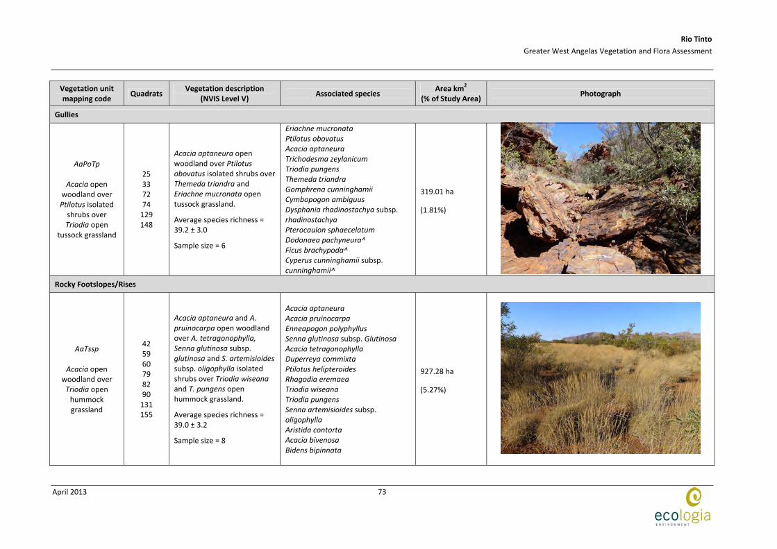
Gullies
AaPoTp
Acacia open woodland over Ptilotus isolated
shrubs over Triodia open
tussock grassland
25 33 72 74
129 148
Acacia aptaneura open woodland over Ptilotus obovatus isolated shrubs over Themeda triandra and Eriachne mucronata open tussock grassland.
Average species richness = 39.2 ± 3.0
Sample size = 6
Eriachne mucronata Ptilotus obovatus Acacia aptaneura Trichodesma zeylanicum Triodia pungens Themeda triandra Gomphrena cunninghamii Cymbopogon ambiguus Dysphania rhadinostachya subsp. rhadinostachya Pterocaulon sphaecelatum Dodonaea pachyneura^ Ficus brachypoda^ Cyperus cunninghamii subsp. cunninghamii^
319.01 ha
(1.81%)
Rocky Footslopes/Rises
AaTssp
Acacia open woodland over Triodia open
hummock grassland
42 59 60 79 82 90
131 155
Acacia aptaneura and A. pruinocarpa open woodland over A. tetragonophylla, Senna glutinosa subsp. glutinosa and S. artemisioides subsp. oligophylla isolated shrubs over Triodia wiseana and T. pungens open hummock grassland.
Average species richness = 39.0 ± 3.2
Sample size = 8
Acacia aptaneura Acacia pruinocarpa Enneapogon polyphyllus Senna glutinosa subsp. Glutinosa Acacia tetragonophylla Duperreya commixta Ptilotus helipteroides Rhagodia eremaea Triodia wiseana Triodia pungens Senna artemisioides subsp. oligophylla Aristida contorta Acacia bivenosa Bidens bipinnata
927.28 ha
(5.27%)
Rio Tinto
Greater West Angelas Vegetation and Flora Assessment
April 2013
74
Vegetation unit mapping code
Quadrats Vegetation description
(NVIS Level V) Associated species
Area km2 (% of Study Area)
Photograph
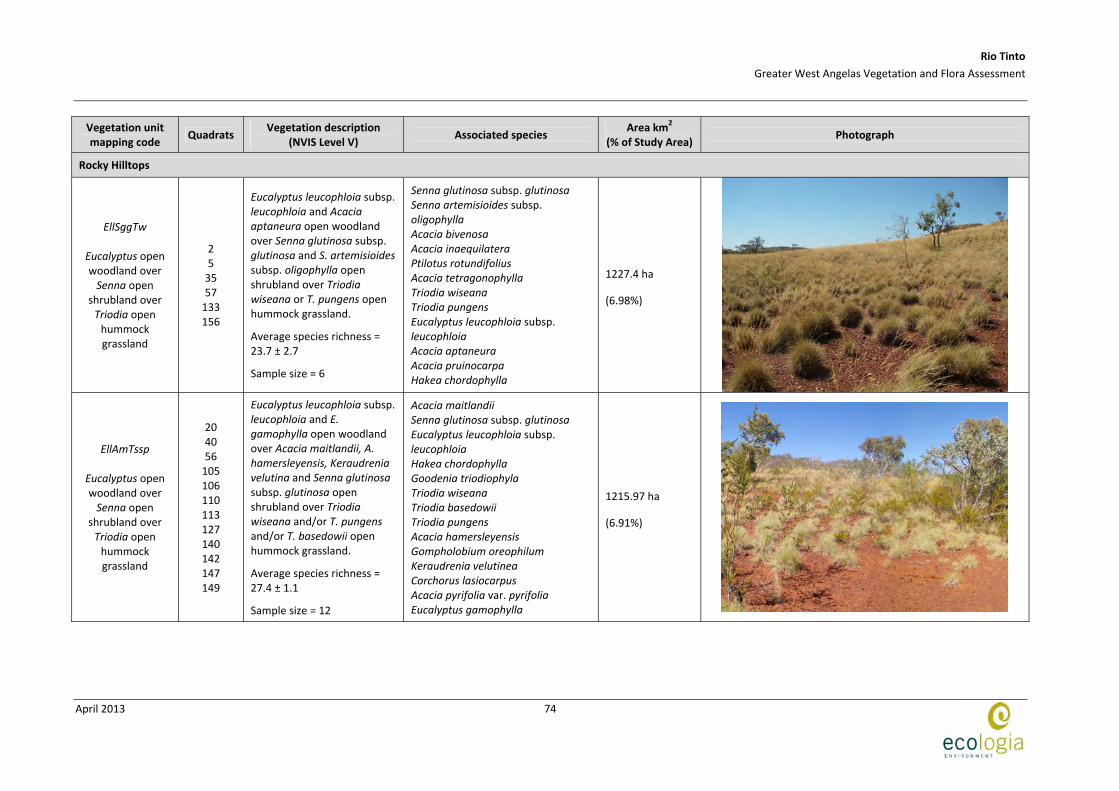
Rocky Hilltops
EllSggTw
Eucalyptus open woodland over Senna open
shrubland over Triodia open
hummock grassland
2 5
35 57
133 156
Eucalyptus leucophloia subsp. leucophloia and Acacia aptaneura open woodland over Senna glutinosa subsp. glutinosa and S. artemisioides subsp. oligophylla open shrubland over Triodia wiseana or T. pungens open hummock grassland.
Average species richness = 23.7 ± 2.7
Sample size = 6
Senna glutinosa subsp. glutinosa Senna artemisioides subsp. oligophylla Acacia bivenosa Acacia inaequilatera Ptilotus rotundifolius Acacia tetragonophylla Triodia wiseana Triodia pungens Eucalyptus leucophloia subsp. leucophloia Acacia aptaneura Acacia pruinocarpa Hakea chordophylla
1227.4 ha
(6.98%)
EllAmTssp
Eucalyptus open woodland over Senna open
shrubland over Triodia open
hummock grassland
20 40 56
105 106 110 113 127 140 142 147 149
Eucalyptus leucophloia subsp. leucophloia and E. gamophylla open woodland over Acacia maitlandii, A. hamersleyensis, Keraudrenia velutina and Senna glutinosa subsp. glutinosa open shrubland over Triodia wiseana and/or T. pungens and/or T. basedowii open hummock grassland.
Average species richness = 27.4 ± 1.1
Sample size = 12
Acacia maitlandii Senna glutinosa subsp. glutinosa Eucalyptus leucophloia subsp. leucophloia Hakea chordophylla Goodenia triodiophyla Triodia wiseana Triodia basedowii Triodia pungens Acacia hamersleyensis Gompholobium oreophilum Keraudrenia velutinea Corchorus lasiocarpus Acacia pyrifolia var. pyrifolia Eucalyptus gamophylla
1215.97 ha
(6.91%)

Rio Tinto
Greater West Angelas Vegetation and Flora Assessment
April 2013
75
Vegetation unit mapping code
Quadrats Vegetation description
(NVIS Level V) Associated species
Area km2 (% of Study Area)
Photograph
AmTw
Acacia sparse shrubland over Triodia hummock
grassland
37 38
136 153
Eucalyptus leucophloia subsp. leucophloia isolated trees over Acacia maitlandii sparse shrubland over Triodia wiseana and T. longiceps hummock grassland.
Average species richness = 17.3 ± 3.8
Sample size = 4
Triodia wiseana Acacia maitlandii Acacia bivenosa Eucalyptus leucophloia subsp. leucophloia Petalostylis labicheoides Ptilotus calostachyus Themeda triandra Triodia longiceps Acacia pyrifolia subsp. pyrifolia Ptilotus nobilis subsp. nobilis Senna artemisioides subsp. oligophylla Melaleuca eleuterostachya^
108.7 ha
(0.62%)
EllSggTp
Eucalyptus open woodland over Senna open
shrubland over Triodia open
hummock grassland
3 11 24 27
103 139 151 152
Eucalyptus leucophloia subsp. leucophloia and Acacia marramambra open woodland over Senna glutinosa subsp. glutinosa open shrubland over Triodia pungens open hummock grassland.
Average species richness = 36.4 ± 3.0
Sample size = 8
Senna glutinosa subsp. glutinosa Eucalyptus leucophloia subsp. leucophloia Aristida contorta Triodia pungens Acacia pruinocarpa Eriachne mucronata Eremophila latrobei subsp. latrobei Ptilotus nobilis subsp. nobilis Enneapogon polyphyllus Ptilotus calostachyus Solanum lasiophyllum Acacia marramamba Acacia aptaneura
2491.87 ha
(14.16%)
Rio Tinto
Greater West Angelas Vegetation and Flora Assessment
April 2013
76
Vegetation unit mapping code
Quadrats Vegetation description
(NVIS Level V) Associated species
Area km2 (% of Study Area)
Photograph
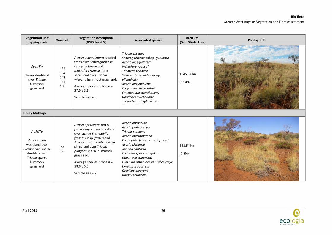
SggIrTw
Senna shrubland over Triodia hummock grassland
132 134 143 144 160
Acacia inaequilatera isolated trees over Senna glutinosa subsp glutinosa and Indigofera rugosa open shrubland over Triodia wiseana hummock grassland.
Average species richness = 27.0 ± 3.6
Sample size = 5
Triodia wiseana Senna glutinosa subsp. glutinosa Acacia inaequilatera Indigofera rugosa^ Themeda triandra Senna artemisioides subsp. oligophylla Acacia dictyophleba Coryotheca micrantha^ Enneapogon caerulescens Goodenia muelleriana Trichodesma zeylanicum
1045.87 ha
(5.94%)
Rocky Midslope
AaEffTp
Acacia open woodland over
Eremophila sparse shrubland and Triodia sparse
hummock grassland
85 65
Acacia aptaneura and A. pruinocarpa open woodland over sparse Eremophila fraseri subsp. fraseri and Acacia marramamba sparse shrubland over Triodia pungens sparse hummock grassland.
Average species richness = 38.0 ± 5.0
Sample size = 2
Acacia aptaneura Acacia pruinocarpa Triodia pungens Acacia marramamba Eremophila fraseri subsp. fraseri Acacia bivenosa Aristida contorta Codonocarpus cotinifolius Duperreya commixta Evolvulus alsinoides var. villosicalyx Exocarpos sparteus Grevillea berryana Hibiscus burtonii
141.54 ha
(0.8%)

Rio Tinto
Greater West Angelas Vegetation and Flora Assessment
April 2013
77
Vegetation unit mapping code
Quadrats Vegetation description
(NVIS Level V) Associated species
Area km2 (% of Study Area)
Photograph
Tp
Triodia hummock grassland
4 15 22 36
Eucalyptus leucophloia subsp. leucophloia and Acacia pruinocarpa isolated trees over Senna glutinosa subsp. glutinosa, A. bivenosa and Ptilotus rotundifolius isolated shrubs over Triodia pungens or T. basedowii or T. sp. Mt Ella hummock grassland.
Average species richness = 16.8 ± 1.5
Sample size = 4
Senna glutinosa subsp. glutinosa Acacia bivenosa Acacia pruinocarpa Ptilotus rotundifolius Eriachne mucronata Eucalyptus leucophloia subsp. leucophloia Ischaemum albovillosum Triodia pungens Cymbopogon ambiguus Eremophila fraseri subsp. fraseri Paspalidium clementii Triodia sp. Mt Ella Templetonia egena^ Senna sericea^
975.86 ha
(5.55%)
ApTssp
Acacia open woodland over Triodia open
hummock grassland
30 58
125 128
Acacia pruinocarpa and Eucalyptus leucophloia subsp. leucophloia open woodland over Senna glutinosa subsp. glutinosa and A. maitlandii isolated shrubs over Triodia basedowii or T. pungens or T. wiseana open hummock grassland.
Average species richness = 15.8 ± 5.7
Sample size = 4
Senna glutinosa subsp. glutinosa Acacia pruinocarpa Eucalyptus leucophloia subsp. leucophloia Acacia maitlandii Senna ferraria Triodia pungens Triodia basedowii Indigofera monophylla Acacia pyrifolia var. pyrifolia Acacia sibirica Corymbia deserticola subsp. deserticola
292.18 ha
(1.66%)
Rio Tinto
Greater West Angelas Vegetation and Flora Assessment
April 2013
78
Vegetation unit mapping code
Quadrats Vegetation description
(NVIS Level V) Associated species
Area km2 (% of Study Area)
Photograph
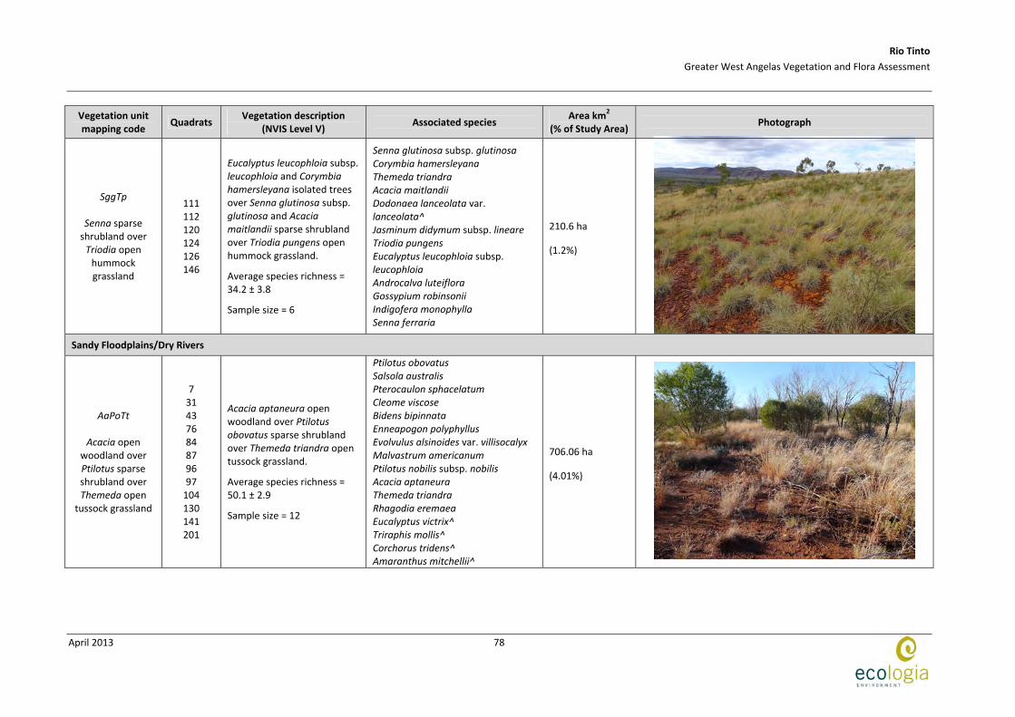
SggTp
Senna sparse shrubland over Triodia open
hummock grassland
111 112 120 124 126 146
Eucalyptus leucophloia subsp. leucophloia and Corymbia hamersleyana isolated trees over Senna glutinosa subsp. glutinosa and Acacia maitlandii sparse shrubland over Triodia pungens open hummock grassland.
Average species richness = 34.2 ± 3.8
Sample size = 6
Senna glutinosa subsp. glutinosa Corymbia hamersleyana Themeda triandra Acacia maitlandii Dodonaea lanceolata var. lanceolata^ Jasminum didymum subsp. lineare Triodia pungens Eucalyptus leucophloia subsp. leucophloia Androcalva luteiflora Gossypium robinsonii Indigofera monophylla Senna ferraria
210.6 ha
(1.2%)
Sandy Floodplains/Dry Rivers
AaPoTt
Acacia open woodland over Ptilotus sparse shrubland over Themeda open
tussock grassland
7 31 43 76 84 87 96 97
104 130 141 201
Acacia aptaneura open woodland over Ptilotus obovatus sparse shrubland over Themeda triandra open tussock grassland.
Average species richness = 50.1 ± 2.9
Sample size = 12
Ptilotus obovatus Salsola australis Pterocaulon sphacelatum Cleome viscose Bidens bipinnata Enneapogon polyphyllus Evolvulus alsinoides var. villisocalyx Malvastrum americanum Ptilotus nobilis subsp. nobilis Acacia aptaneura Themeda triandra Rhagodia eremaea Eucalyptus victrix^ Triraphis mollis^ Corchorus tridens^ Amaranthus mitchellii^
706.06 ha
(4.01%)

Rio Tinto
Greater West Angelas Vegetation and Flora Assessment
April 2013
79
Vegetation unit mapping code
Quadrats Vegetation description
(NVIS Level V) Associated species
Area km2 (% of Study Area)
Photograph
AaTt
Acacia woodland over Themeda open tussock
grassland
55 99
123 135 137 138 145
Acacia aptaneura and Eucalyptus xerothermica woodland over Ptilotus obovatus isolated shrubs over Themeda triandra open tussock grassland
Average species richness = 44.6 ± 2.3
Sample size = 7
Themeda triandra Aristida contorta Pterocaulon sphacelatum Enneapogon polyphyllus Ptilotus nobilis subsp. nobilis Cleome viscose Duperreya commixta Evolvulus alsinoides var. villisocalyx Acacia aptaneura Eucalyptus xerothermica Ptilotus obovatus Capparis lasiantha Eucalyptus trivalva^
391.54 ha
(2.23%)
Floodplains/Drainage lines
AaAc
Acacia open woodland over Aristida sparse
tussock grassland
9 12 45 46 47 64 67 69 78 89
Acacia aptaneura and A. pruinocarpa open woodland over Aristida contorta sparse tussock grassland over Pterocaulon sphacelatum and Ptilotus nobilis subsp. nobilis isolated forbs.
Average species richness = 37.7 ± 2.8
Sample size = 10
Acacia aptaneura Pterocaulon sphacelatum Ptilotus nobilis subsp. nobilis Abutilon otocarpum Enneapogon polyphyllus Aristida contorta Acacia pruinocarpa Ptilotus helipteroides Salsola australis Evolvulus alsinoides var. villisocalyx Triodia pungens Senna artemisioides subsp. oligophylla Senna notabilis
505.39 ha
(2.87%)

Rio Tinto
Greater West Angelas Vegetation and Flora Assessment
April 2013
80
Vegetation unit mapping code
Quadrats Vegetation description
(NVIS Level V) Associated species
Area km2 (% of Study Area)
Photograph
AaSaoTp
Acacia open woodland over Senna sparse
shrubland over Triodia open
hummock grassland
10 19 41 44 54 80 86
154
Acacia aptaneura and A. ayersiana open woodland over Senna artemisioides subsp. oligophylla, S. glutinosa subsp. glutinosa and Eremophila forrestii subsp. forrestii sparse shrubland over Triodia pungens open hummock grassland.
Average species richness = 44.8 ± 2.8
Sample size = 9
Acacia aptaneura Senna artemisioides subsp. oligophylla Senna glutinosa subsp. glutinosa Aristida contorta Evolvulus alsinoides var. villisocalyx Hibiscus burtonii Triodia pungens Eremophila forrestii subsp. forrestii Acacia pruinocarpa Eriachne pulchella subsp. dominii Euphorbia australis Sida sp. spiciform panicles Acacia ayersiana
447.27 ha
(2.54%)
EgSggTb
Eucalyptus open woodland over Senna sparse
shrubland over Triodia open
hummock grassland
17 93
116 117 119 122
Eucalyptus gamophylla and Corymbia deserticola subsp. deserticola open woodland over Senna artemisioides subsp. oligophylla and Indigofera monophylla sparse shrubland over Triodia basedowii and T. pungens open hummock grassland.
Average species richness = 32.7 ± 3.5
Sample size = 6
Keraudrenia velutina Senna glutinosa subsp. glutinosa Paraneurachne muelleri Ptilotus calostachyus Triodia basedowii Triodia pungens Eucalyptus gamophylla Acacia bivenosa Acacia adsurgens Corymbia deserticola subsp. deserticola Ptilotus nobilis subsp. nobilis Solanum lasiophyllum Acacia ancistrocarpa^
309.52 ha
(1.76%)
Sandy Plain
Rio Tinto
Greater West Angelas Vegetation and Flora Assessment
April 2013
81
Vegetation unit mapping code
Quadrats Vegetation description
(NVIS Level V) Associated species
Area km2 (% of Study Area)
Photograph
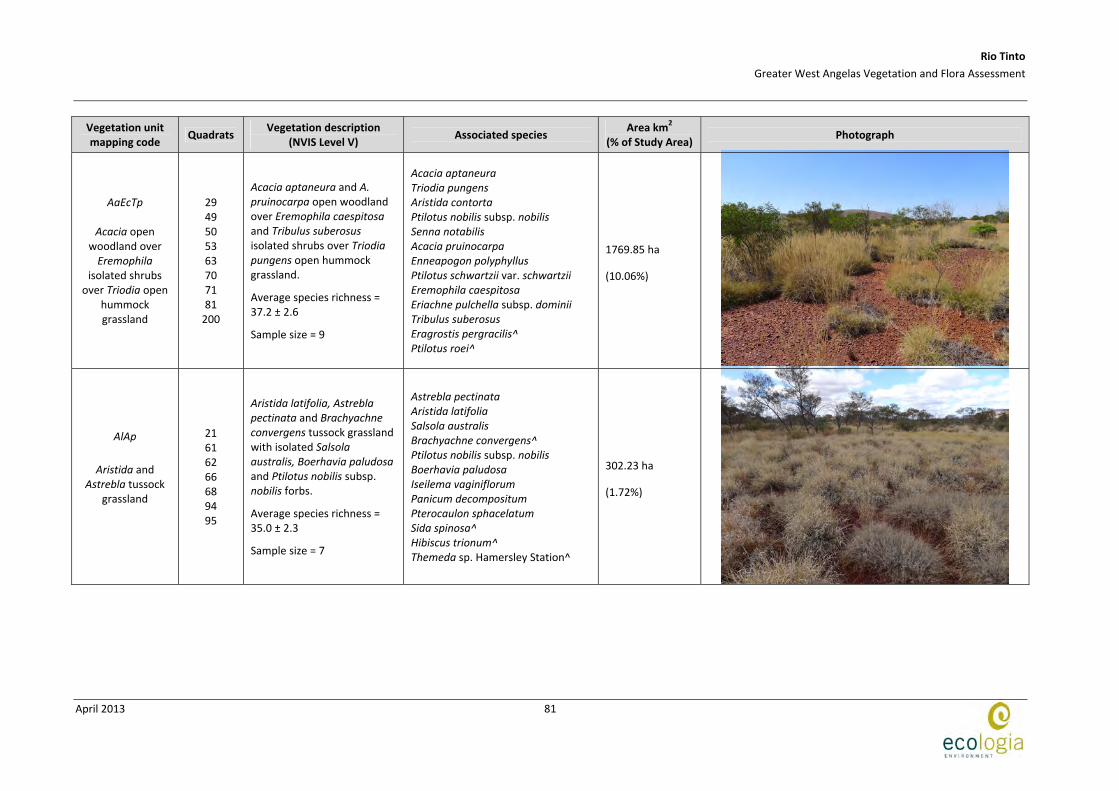
AaEcTp
Acacia open woodland over Eremophila
isolated shrubs over Triodia open
hummock grassland
29 49 50 53 63 70 71 81
200
Acacia aptaneura and A. pruinocarpa open woodland over Eremophila caespitosa and Tribulus suberosus isolated shrubs over Triodia pungens open hummock grassland.
Average species richness = 37.2 ± 2.6
Sample size = 9
Acacia aptaneura Triodia pungens Aristida contorta Ptilotus nobilis subsp. nobilis Senna notabilis Acacia pruinocarpa Enneapogon polyphyllus Ptilotus schwartzii var. schwartzii Eremophila caespitosa Eriachne pulchella subsp. dominii Tribulus suberosus Eragrostis pergracilis^ Ptilotus roei^
1769.85 ha
(10.06%)
AlAp
Aristida and Astrebla tussock
grassland
21 61 62 66 68 94 95
Aristida latifolia, Astrebla pectinata and Brachyachne convergens tussock grassland with isolated Salsola australis, Boerhavia paludosa and Ptilotus nobilis subsp. nobilis forbs.
Average species richness = 35.0 ± 2.3
Sample size = 7
Astrebla pectinata Aristida latifolia Salsola australis Brachyachne convergens^ Ptilotus nobilis subsp. nobilis Boerhavia paludosa Iseilema vaginiflorum Panicum decompositum Pterocaulon sphacelatum Sida spinosa^ Hibiscus trionum^ Themeda sp. Hamersley Station^
302.23 ha
(1.72%)

Rio Tinto
Greater West Angelas Vegetation and Flora Assessment
April 2013
82
Vegetation unit mapping code
Quadrats Vegetation description
(NVIS Level V) Associated species
Area km2 (% of Study Area)
Photograph
PsTp
Pterocaulon sparse forbland
with Triodia open hummock grassland
51 52
108
Acacia aptaneura or A. ayersiana open woodland over Pterocaulon sphacelatum and Dysphania kalparri sparse forbland with Triodia pungens open hummock grassland.
Average species richness = 36.7 ± 2.6
Sample size = 3
Pterocaulon sphacelatum Dysphania kalpari Aristida contorta Enneapogon polyphyllus Aristida jerichoensis var. subspinulifera^ Cucumis variabilis Euphorbia drummondii Panicum effusum Sida sp. verrucose glands Triodia pungens Themeda triandra
174.39 ha
(0.99%)
Sandy Undulating Plain
AaTp
Acacia woodland over Triodia open
hummock grassland
18 48 77 91
115 118
Acacia pruinocarpa, A. aptaneura and A. ayersiana woodland over Triodia pungens open hummock grassland.
Average species richness = 29.3 ± 3.9
Sample size = 6
Acacia aptaneura Triodia pungens Acacia pruinocarpa Aristida contorta Hibiscus burtonii Solanum lasiophyllum Acacia ayersiana Enneapogon polyphyllus Ptilotus nobilis subsp. nobilis Ptilotus obovatus Senna glutinosa subsp. glutinosa
982.26 ha
(5.58%)