Embed Size (px)
Citation preview

1
Conservation & Management Plan Colorado Lagoon Western Arm Natural Area
Conservation & Management Plan
Colorado Lagoon
Western Arm Natural Area
Prepared by
Tidal Influence 1340 E. Florida St Long Beach, CA 90802
Prepared for
Friends of Colorado Lagoon 6475 E. PCH #252 Long Beach, CA 90803
Funded by
Rivers & Mountains Conservancy 100 N. Old San Gabriel Canyon Rd. Azusa, CA 91702

2
Table of Contents Introduction ......................................................................................................................................... 4
Conservation and Management Plan Overview ....................................................................................... 4
Purpose of Plan ......................................................................................................................................... 4
Colorado Lagoon Restoration Project Objectives ..................................................................................... 4
Western Arm Short-Term Management Objectives ................................................................................. 4
Western Arm Long-Term Maintenance Objectives .................................................................................. 4
The Colorado Lagoon ........................................................................................................................... 5
Historical Uses of Land .............................................................................................................................. 5
Recent Restoration Efforts ........................................................................................................................ 6
− Storm Drain Improvements ...................................................................................................... 6
− Improvements to Tidal Flow ..................................................................................................... 6
− Removal of Contaminants ......................................................................................................... 6
Creation of Western Arm Natural Area .................................................................................................... 7
The Western Arm Natural Area ............................................................................................................ 8
Maps and Habitat Delineations ................................................................................................................ 9
Terrestrial Habitats ................................................................................................................................. 10
Native Plant Communities and Care Requirements ........................................................................... 10
Coastal Sage Scrub .......................................................................................................................... 10
Maintenance ................................................................................................................................... 10
Coastal Strand ................................................................................................................................. 11
Freshwater Wetland (Bioswale) ...................................................................................................... 12
Transition Zone ............................................................................................................................... 13
Intertidal Salt Marsh ....................................................................................................................... 13
Special Status Species ......................................................................................................................... 18
Non-native Plants and Management Techniques ............................................................................... 20
Mulching ......................................................................................................................................... 20
Hand weeding ................................................................................................................................. 20
Pesticide Application ....................................................................................................................... 20
Weed Whacking .............................................................................................................................. 20
Solarization ..................................................................................................................................... 21

3
Controlled Burns ............................................................................................................................. 21
Marine Habitats ...................................................................................................................................... 25
Mudflats .............................................................................................................................................. 25
Subtidal ............................................................................................................................................... 25
Water Quality ...................................................................................................................................... 26
Fauna of Colorado Lagoon ...................................................................................................................... 27
Management Issues Regarding Fauna ................................................................................................ 27
Monitoring Protocols .............................................................................................................................. 39
Standard Procedures for Vegetation Monitoring ............................................................................... 40
Standard Operating Procedures for Avifauna Monitoring.................................................................. 43
Standard Procedures for Ichthyofauna Monitoring ............................................................................ 45
Public Access ........................................................................................................................................... 48
Recreation ........................................................................................................................................... 48
Trails .................................................................................................................................................... 48
Easements ........................................................................................................................................... 48
Community Involvement .................................................................................................................... 48
Homeless and Trespassing .................................................................................................................. 48
Neighbors and Viewsheds ................................................................................................................... 48
Site Facilities............................................................................................................................................ 49
Irrigation.............................................................................................................................................. 49
Golf Course Interface .......................................................................................................................... 50
Educational Kiosks ............................................................................................................................... 50
Trails, Fences, & Gates ........................................................................................................................ 51
Hydrology ................................................................................................................................................ 52
Erosion ................................................................................................................................................ 52
Sea Level Rise ...................................................................................................................................... 53
Tables & Figures Index ....................................................................................................................... 54
4
Introduction
Conservation and Management Plan Overview The Colorado Lagoon Conservation and Management Plan (CMP) identifies the restoration priorities addressed in the Colorado Lagoon Restoration and Revegetation Project and the steps necessary to protect and preserve the improvements made to habitats and facilities. This CMP is not developed as a compliance guide, but rather as a primary tool for the achievement of best management practices on a project supported by competitive grant and corporate funding sources. Each chapter of this CMP describes one element of the Western Arm’s restoration objectives and includes a description of current conditions, management issues within the topic, and recommendations for approaching and resolving said management issues.
Purpose of Plan This CMP was developed cooperatively by Tidal Influence and Friends of Colorado Lagoon (FOCL) for the City of Long Beach, the landowner. This document is intended to (1) provide guidance for habitat and facility maintenance efforts, (2) promote continuity and consistency of habitat management techniques in the Western Arm Natural Area, and (3) provide a framework for management in other areas of the Colorado Lagoon and adjacent natural spaces.
Colorado Lagoon Restoration Project Objectives Restoration objectives for the Colorado Lagoon Restoration and Revegatation Project include:
− Restoration of 5.5 acres of native coastal habitats, which include subtidal, coastal salt marsh, coastal strand, coastal sage scrub, transition zone, and freshwater wetlands
− Aesthetic improvement of site
− Enhancement of passive public recreation opportunities
− Improvement of water quality and public health
− Provision of environmental educational opportunities
Western Arm Short-Term Management Objectives − Control public access and deflect non-beneficial uses to minimize impacts to habitat health
− Continue regular maintenance and removal of trash and debris
− Determine and implement temporary measures to reduce erosion during plant establishment phase
− Installation of native plants to maintain aesthetic value and a high percent coverage of native landscaping
− Monitor water quality and other ecological constituents
Western Arm Long-Term Maintenance Objectives To maintain existing diversity of native flora for the integrity of habitat value and public appreciation:
− Ongoing monitoring and management of non-native weed populations
− Establish sustainable habitat for local native wildlife by maintaining native plant species diversity and coverage
− Implement best management practices to maintain high water quality standards
− Maintain the accessibility and functionality of irrigation infrastructure and other site facilities

5
The Colorado Lagoon
Historical Uses of Land Colorado Lagoon is a human-made geomorphological feature located within the historical range of Los Cerritos Wetlands, which once boasted more than 2400 acres of coastal wetlands at the heart of the incredibly diverse California Floristic Province. This wetland’s acreage has been reduced to just 500 acres of open space, much of which is privately owned and operated for industrial purposes. Conversely, Colorado Lagoon has been managed by the City of Long Beach since the 1920s as a park and recreational area. In 1923, the naturally occurring tidal wetlands of Alamitos Bay were dredged to form the Lagoon and Marine Stadium. The lagoon became the site of the 1932 U.S. Olympic Diving Trials in Los Angeles and was separated from Marine Stadium (the site for rowing competitions) by tide gates designed to maintain an adequate water depth during diving events. Afterward the Lagoon became such a popular swimming and recreation site that lights were provided at night and lifeguards were on duty 24 hours per day, 7 days per week. It is even rumored that John Wayne was once a lifeguard at the Lagoon. The late 1960s marked the decline of the lagoon’s health with the first restriction of its connection to the ocean and subsequent drop in water quality. The north end of Marine Stadium was filled for a never-executed crosstown freeway; this filled area became Marina Vista Park. After this construction, the lagoon was reduced to an 18 acre tidal water body connected to Alamitos Bay via a 900 foot box culvert that runs under Marina Vista Park into Marine Stadium. Over the course of several decades a golf course, parking lots, recreational beaches, parks, and residential areas were built up around the Lagoon. Development entirely surrounded the lagoon’s edges which resulted in an urban watershed impacting the Lagoon’s water quality via 11 storm drains. These watershed impacts, coupled with the Lagoon’s restricted tidal range, contributed to the gradual accumulation of contaminants in the water and sediment. Over time, the Colorado Lagoon earned the dubious honor of having one of the worst water quality conditions in the state. Heal the Bay ranked Colorado Lagoon as one of the “Top 10 Biggest Beach Bummers” in the organization’s 2011 Annual Beach Report Card; since spring 2007, the Lagoon’s beaches have received “F” grade each year regardless of the season. This poor water quality was of great concern as thousands of people come to Colorado Lagoon every summer to swim and fish.
Photo 1: Overlay map of historical wetlands and the modern day Alamitos Bay
Photo 2: Aerial view looking north at Marine Stadium and Colorado Lagoon – 1929 (Long Beach City Engineer)
Photo 3: U.S. Olympic Trials swimming event – c.1932 (Recreation Department)
Photo 4: Lifeguard and swimmers at Colorado Lagoon – June 1937 (Recreation Department)

6
Recent Restoration Efforts Resulting from this concern were several large restoration projects that have vastly improved both public health and recreation opportunities and the ecological function of the lagoon:
− Storm Drain Improvements: 1. Three of Colorado Lagoon’s storm drains were upgraded by the
installation of low flow diversion systems and trash separation devices. Via this system, dry weather drainage that would normally enter the lagoon through these drains was redirected into a vault, which releases the wastewater into the sewer system during much of the year.
2. The remaining seven storm drains have all been diverted away from the lagoon as part of Los Angeles County’s Termino Avenue Drain Project. Water in the lagoon now has a 7.7 day residence period; additional restoration actions will be necessary to decrease this time to the 6.0 day residence time observed in Marine Stadium.
3. A 600 foot bioswale was constructed in the Western Arm between the golf course and the lagoon. This bioswale transformed a drain, which formerly transferred runoff directly to marine waters, into a phytoremediation system designed to filter out fertilizers and other pollutants before reaching the wetlands.
− Improvements to Tidal Flow: The culvert connection between the Lagoon and Marine Stadium was cleaned for the first time since its construction in the 1960s. This sensitive endeavor required the lagoon to be cut off from tidal influence for nearly two weeks in order to complete the cleaning. However, the removal of three feet of marine sediment, running the entire length of the culvert, decreased the residence time of tidal waters entering the lagoon.
− Removal of Contaminants: A large dredging and bank resloping project was performed to (1) remove numerous organic and inorganic pollutants that contaminated the lagoon’s sediment and (2) increase intertidal habitat. Approximately 74,000 cubic yards of sediment were removed from the lagoon during this phase.
Since February 2012, water quality ratings from Heal the Bay have been consistently high, with a few exceptions occurring during periods of heavy rainfall.
Photo 5: Newly contoured bioswale on the north bank of the Western Arm prior to planting (Zahn)
Photo 6: Installation of a trash separation device on one of the remaining storm drain outfalls (Zahn)
Photo 7: Inside view of an empty low flow-diversion chamber (Pirazzi)
Photo 8: Cleaning the 900ft culvert that run under Marina Vista Park, connecting the Colorado Lagoon to Marine Stadium (Pirazzi)
Photo 9: Dredging in the Western Arm; over 70,000 cubic feet of dredge material were removed from the Lagoon and transported to the Port of Long Beach for use in their Middle Harbor project (Pirazzi)

7
Creation of Western Arm Natural Area The large-scale construction projects executed at the Colorado Lagoon provided opportunity to establish a native plant regime and recreate habitats that may have once existed at Colorado Lagoon. Additionally, various areas in and near the Colorado Lagoon are designated for recreational activities such as swimming, fishing, hiking, and golf. Finding a balance between human activity and habitat is vital to the success of the lagoon’s restoration; in Fall 2012 with funding provided several entities, the Western Arm Natural Area was created to help achieve this balance. Partners in restoration for this project included:
− Rivers and Mountains Conservancy
− National Fish and Wildlife Foundation
− Port of Long Beach
− California Office of Spill Prevention and Response
− California Native Plant Society- South Coast Chapter
− Society of Environmental Toxicology and Chemistry
− Wells Fargo
Since the determination was made to create the Western Arm Natural Arm, many measures have been integrated into the restoration process to ensure the habitat’s integrity and sustainability. Prior to the dredging and re-contouring efforts, salt marsh plant plugs were salvaged from the Western Arm and used as stock from which smaller plants were propagated. Additional propagules were collected from Los Cerritos Wetlands. These practices ensured that all salt marsh plants are genetically native to the area; this factor is especially important when working with coastal salt marsh plants, as these species hybridize easily. After the dredging project was completed and the Colorado Lagoon was once again readily accessible, perimeter fences were installed to outline the Western Arm boundary and deflect windblown trash. Mulch was then applied to delineate habitat zones (which will be discussed in more detail in upcoming sections of this document), to increase water absorption and retention in the sediment, to curtail erosion, and to serve as a non-native plant control method. After these efforts were completed, the installation of native plants commenced. To minimize the risk of trampling or other damage to the newly installed habitats, plantings were first performed in the intertidal zones and subsequently moved upwards in elevation. Care was taken to place any rare species in areas of least potential impact, and salt marsh areas – arguably the most sensitive habitat installed in the Western Arm Natural Reserve – were planted by a team trained in salt marsh restoration techniques and supervised by a salt marsh ecologist. Considerations given in the upland habitats included aesthetic values and neighborhood viewsheds.

8
The Western Arm Natural Area The Western Arm Natural Area is located on the distal end of the west Arm of the Lagoon, easily viewed from Park Avenue and Appian Way. A detailed map of the Colorado Lagoon can found on the next page. This area of the Colorado Lagoon was created with the intent that it be accessed seldom by people and serve as a higher quality area of habitat for the animals utilize the Lagoon. However, as it is entirely surrounded by development, urban impacts will occur and measures have been taken to ensure that public interactions with the Western Arm Natural Area are positive. The following pages will detail these steps, how they should be maintained, and other elements found in the Western Arm.
Photo 10: A panoramic view of the Western Arm Natural Area post-restoration (Graves)

9
Maps and Habitat Delineations
Figure 1: Map of Colorado Lagoon, highlighting the Western Arm Natural Area
Figure 2: Close up of Western Arm Natural Area, with habitat types delineated
10
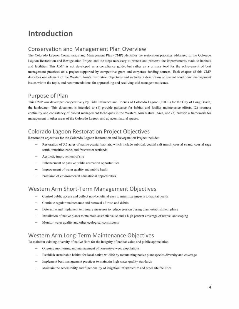
Terrestrial Habitats Native Plant Communities and Care Requirements Coastal Sage Scrub The coastal sage scrub community evolved in a Mediterranean climate, which occurs between 30 and 40 degrees latitude, rarely experiences freezing temperatures or prolonged periods of heat above 90ºF, and receives 10-20 inches of rainfall annually. Some species such as Peritoma arborea or Artemisia californica have specialized leaves that store moisture and reduce water loss during dry months, have very few signs of above-ground life, and expend energy growing a stronger root system. Having evolved in a dry, fire-prone climate, this plant community is fire adapted; several of the more succulent species are fire retardant. Despite these adaptations, a large variety of coastal sage scrub species are attractive when used in urban landscaping and bear brightly colored inflorescences. Maintenance Most coastal sage scrub areas in the Western Arm can be watered using the automatic irrigation system. Periodic site checks to verify proper coverage are recommended, and manual spot watering may be required. After native perennials are fully mature, their water needs are very low; watering is only required for the establishment of young perennials and annuals. Supplemental watering may be useful to promote additional vegetative growth or prolong blooming periods. Please refer to the irrigation section of this document for full operating and maintenance instructions. Non-native control in this habitat type includes several effective techniques, the most common of which are hand-weeding, action hoeing, approved pesticide application, and mulching. Please refer to Table 4 for a complete list of non-native control techniques. Continuing restoration and maintenance efforts must consider viewsheds, especially when working in the coastal sage scrub community. Many CSS plant species can grow to be 10-15 feet in height and width; care has been taken to exclude these species from specific areas to lessen their visual impact. Frontage areas (abutting the Appian Way and Park Avenue fencelines) have been planted with low-growing perennials and annuals to allow for a larger, more appealing view. In these areas, any additional plantings should adhere to the species already found in the area to maintain the landscape profile. As this habitat matures, native seeds may germinate in areas in which a plant is not desirable (such as on a trail or an entrance to a facility). The solution to this management issue will require assessment of each individual case. Options to consider are 1) salvaging and relocating to a more appropriate location, 2) trimming to prevent obstruction of access, and 3) removing the plant entirely. Retaining native vegetation to the greatest possible should be prioritized. Approximately 50 native plant species are found in the Western Arm’s coastal sage scrub area; for a complete list, please refer to Table 1. Notable amongst these plants are two vine species: Marah macrocarpus (Manroot) and Calystegia macrostachya (Island morning glory). These plants were included to achieve fast ground coverage for the reduction of erosion, for their aesthetic value, and because they are often overlooked in CSS restorations. These vine species will grow over and completely cover other natives around them; trimming is only necessary if a plant is negatively impacting access or facilities.
Photo 11: Wildflowers blooming in the coastal sage scrub plant community (Tidal Influence)

11
As this is both a habitat and a visually impactful element of the Colorado Lagoon, occasional aesthetic maintenance will be necessary. Tasks in this habitat type include:
− Trimming mature native plants that appear partially or completely dead
− Clipping senesced seed heads from native perennials
− Maintaining native annual seed bank. Seeds should be dispersed in the field at the beginning or height of the rainy season
− Removing native annual plants that have senesced and dropped their seed
− Replenishing mulch as need be to prevent bare ground from being visible In addition to being an aesthetic tool, the application of mulch can also benefit this habitat type by improving moisture retention in soils, diminishing non-native plant establishment, and reducing erosion. Coastal Strand Dunes, sand beaches, and bluffs along the entire coast offer a harsh environment for the few plant species that inhabit them. Bluff and dune habitats are often adjacent to salt marshes. Loose sand, sea salt, fog, isolation, wind, and foot traffic create impossible conditions for some species. Plants such as verbena, beach evening primrose, and beach bur are adapted to survive under such impacts and are dominant species in the coastal strand plant palette for the Western Arm Natural Area. Maintenance There is no automatic irrigation system in this area due to erosion concerns; a dripline can be moved into the site to aid watering efforts. Watering can also be done by hand and should be performed to aid in the establishment of immature perennials and the germination and growth of annuals. Mature plants have minimal water requirements. Straw wattles run along the lower boundary of the coastal strand area, separating this habitat type from the transition zone. These wattles (also called fiber rolls) have been installed as a temporary measure to reduce erosion and serve as a seed catch. Denser-than-average populations of native annuals have been observed along the high edge of the rolls. Fiber rolls will decompose over time and do not need to be removed from the site. Non-native control techniques in this area are limited due to growth patterns of the native plants. Suggested methods are hand weeding and application of approved pesticides. As the plants in this area are adapted to sandy substrates, no mulching should be performed. If sand replenishment is necessary, please refer to the erosion section of this document. Aesthetic maintenance of this habitat type will be largely comprised of hand-trimming annuals and perennials that have senesced. Weed whacking is not an advisable technique for this task. In Demonstration Gardens, which are discussed further below, aesthetic maintenance should be emphasized over habitat function due to its high visibility and purpose as a buffer.
Photo 12: Coastal strand habitat, with Acmispon glaber and Ambrosia chamissonis dominant (Graves)
12
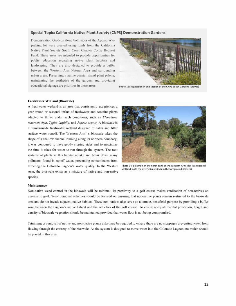
Freshwater Wetland (Bioswale) A freshwater wetland is an area that consistently experiences a year–round or seasonal influx of freshwater and contains plants adapted to thrive under such conditions, such as Eleocharis macrostachya, Typha latifolia, and Juncus acutus. A bioswale is a human-made freshwater wetland designed to catch and filter surface water runoff. The Western Arm’ s bioswale takes the shape of a shallow channel running along its northern boundary; it was contoured to have gently sloping sides and to maximize the time it takes for water to run through the system. The root systems of plants in this habitat uptake and break down many pollutants found in runoff water, preventing contaminants from affecting the Colorado Lagoon’s water quality. In the Western Arm, the bioswale exists as a mixture of native and non-native species.
Maintenance Non-native weed control in the bioswale will be minimal; its proximity to a golf course makes eradication of non-natives an unrealistic goal. Weed removal activities should be focused on ensuring that non-native plants remain restricted to the bioswale area and do not invade adjacent native habitats. These non-natives also serve an alternate, beneficial purpose by providing a buffer zone between the Lagoon’s native habitat and the activities of the golf course. To ensure adequate habitat protection, height and density of bioswale vegetation should be maintained provided that water flow is not being compromised. Trimming or removal of native and non-native plants alike may be required to ensure there are no stoppages preventing water from flowing through the entirety of the bioswale. As the system is designed to move water into the Colorado Lagoon, no mulch should be placed in this area.
Special Topic: California Native Plant Society (CNPS) Demonstration Gardens
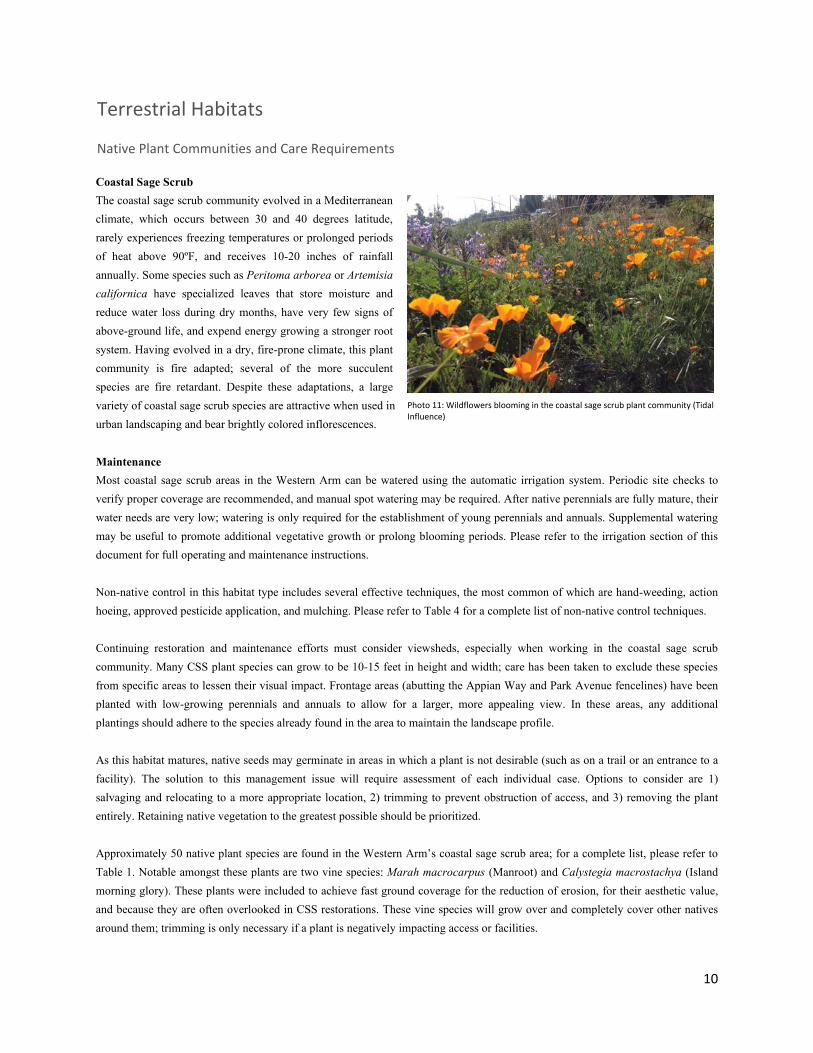
Demonstration Gardens along both sides of the Appian Way parking lot were created using funds from the California Native Plant Society South Coast Chapter Conze Bequest Fund. These areas are intended to provide opportunities for public education regarding native plant habitats and landscaping. They are also designed to provide a buffer between the Western Arm Natural Area and surrounding urban areas. Preserving a native coastal strand plant palette, maintaining the aesthetics of the garden, and providing educational signage are priorities in these areas.
Photo 13: Vegetation in one section of the CNPS Beach Gardens (Graves)
Photo 14: Bioswale on the north bank of the Western Arm. This is a seasonal wetland; note the dry Typha latifolia in the foreground (Graves)

13
Transition Zone The transition zone - also referred to as an “ecotone” – is a narrow strip of land that is situated between the coastal salt marsh and upland plant communities. It occurs directly above the mean high tide line, which produces highly saline soils that few plants are adapted to survive in. Here you find a mixture of upland and wetland plants, as well as certain species that are specialized to live in this ecotone. Some dominant species in this habitat type are Suaeda taxifolia, Lycium californicum, and Isocoma menziesii. Several of these endemic species have become rare in southern California due to encroachment from developments, the placement of walking trails along marsh edges, and from the invasion of non-native plant species. Many terrestrial animals that use the marsh during low tides depend on the transition zone for cover during high tides. Please refer to the section on sea level rise for other functions of the transition zone.
Maintenance Due to the sensitivity of many plants in this habitat type, impacts and entry in this area should be kept to a minimum. No mulch should be placed in the transition zone due to its proximity to the intertidal zone. Non-native plant control should be performed by hand weeding. Watering should be performed by hand or by utilizing a temporary dripline, which can be moved and altered as the habitat necessitates. Additionally, watering will decrease salinity is soils, which may result in higher levels of non-native plant germination.
Intertidal Salt Marsh This plant community is found within a 2 to 3 meter elevation range along sheltered margins of bays, lagoons, and estuaries that are subject to regular inundation by seawater. It is dominated by highly herbaceous plants that are adapted to tolerate high doses of water and salt. Plant species are segregated by elevation with Spartina foliosa (Pacific cordgrass) dominating the low marsh, Salicornia pacifica (Common pickleweed) and Jaumea carnosa (Fleshy jaumea) in the middle marsh, and Distichlis spicata (Salt grass) and Distichlis littoralis (Shoregrass) in the high marsh. Unvegetated tidal areas, known as salt pannes, often form in the upper marsh where soil salinities may reach as high as 200 parts per thousand (ppt); sea water is 35 ppt.
Maintenance After initial plantings, native salt marsh plants will benefit from fresh water influxes; hand watering will promote their establishment and should be performed. After plants are established, ocean tides will provide adequate water for their survival. Additional watering should not be performed at this time, as it may result in increased non-native plant cover. Non-native plants should be removed by hand only and with low frequency. The disturbance caused by entering salt marsh habitat is often more damaging than the presence of a non-native plant; all activities should take place under the supervision of a salt marsh
Photo 16 – A mature, diverse array of salt marsh plants (Graves)
Photo 15: Suaeda taxifolia, a rare plant that thrives in the Lagoon’s transition zone, living above the high tide line (Graves)
14
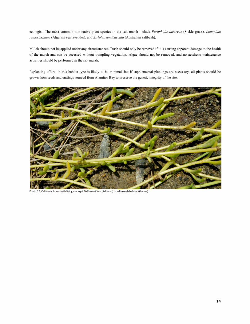
ecologist. The most common non-native plant species in the salt marsh include Parapholis incurvus (Sickle grass), Limonium ramosissimum (Algerian sea lavender), and Atriplex semibaccata (Australian saltbush). Mulch should not be applied under any circumstances. Trash should only be removed if it is causing apparent damage to the health of the marsh and can be accessed without trampling vegetation. Algae should not be removed, and no aesthetic maintenance activities should be performed in the salt marsh. Replanting efforts in this habitat type is likely to be minimal, but if supplemental plantings are necessary, all plants should be grown from seeds and cuttings sourced from Alamitos Bay to preserve the genetic integrity of the site.
Photo 17: California horn snails living amongst Batis maritima (Saltwort) in salt marsh habitat (Graves)

15
The native plants species listed in the table below are organized alphabetically rather than family for readability and straightforward access to information. Annual species are denoted by an asterisk (*).
Table 1: Native Plants of Colorado Lagoon’s Western Arm Scientific Name Common Name SM TZ CSS FW CS Achillea millefolium* Yarrow ∙ ∙ Acmispon glaber Deerweed ∙ ∙ Agave shawii Coastal agave ∙ Alnus rhombifolia White alder ∙ Ambrosia chamissonis Silver beach bur ∙ Ambrosia psilostachya Western ragweed ∙ ∙ Anemopsis californica Yerba mansa ∙ Artemisia californica California sagebrush ∙ Arthrocnemum subterminale Parish’s glasswort ∙ ∙ Astragalus trichopodus Southern California locoweed ∙ Atriplex lentiformis Quailbush ∙ Atriplex watsonii Matscale ∙ Baccharis pilularis Coyotebush ∙ Baccharis salicifolia Mulefat ∙ ∙ Baccharis salicina Emory’s baccharis ∙ ∙ Batis maritima Saltwort ∙ Calystegia macrostegia Island morning glory ∙ Calystegia soldanella Beach morning glory ∙ Camissonia cheiranthifolia Beach evening primrose ∙ Castilleja exserta* Purple owl’s clover ∙ Ceanothus megacarpus Big pod ceanothus ∙ Clarkia amoena* Farewell-to-spring ∙ ∙ Clarkia unguiculata* Elegant clarkia ∙ Conyza canadensis Canadian horseweed ∙ Coreopsis gigantea Giant coreopsis ∙ Coreopsis maritima Sea dahlia ∙ Cressa truxillensis* Alkali weed ∙ Cuscuta salina Salt marsh dodder ∙ ∙ Cylindropuntia prolifera Coastal cholla ∙ Cyperus eragrostis Tall flatsedge ∙ Dichelostemma capitatum* Blue dicks ∙ Distichlis littoralis Shoregrass ∙ ∙ Distichlis spicata Saltgrass ∙ ∙ Dudleya edulis Dead man’s fingers ∙ Dudleya pulverulenta Chalk dudleya ∙ Dudleya virens Green live-forever ∙ ∙ Eleocharis macrostachia Spike rush ∙ Encelia californica California bush sunflower ∙ Epilobium canum California fuschia ∙ ∙ Ericameria ericoides Mock heather ∙ Eriogonum cinereum Ashy-leaf buckwheat ∙ Eriogonum fasciculatum California buckwheat ∙ Eriogonum gigantea St. Catherine’s Lace ∙ Eriogonum parvifolium Dune buckwheat ∙ Eschscholzia californica California poppy ∙ ∙
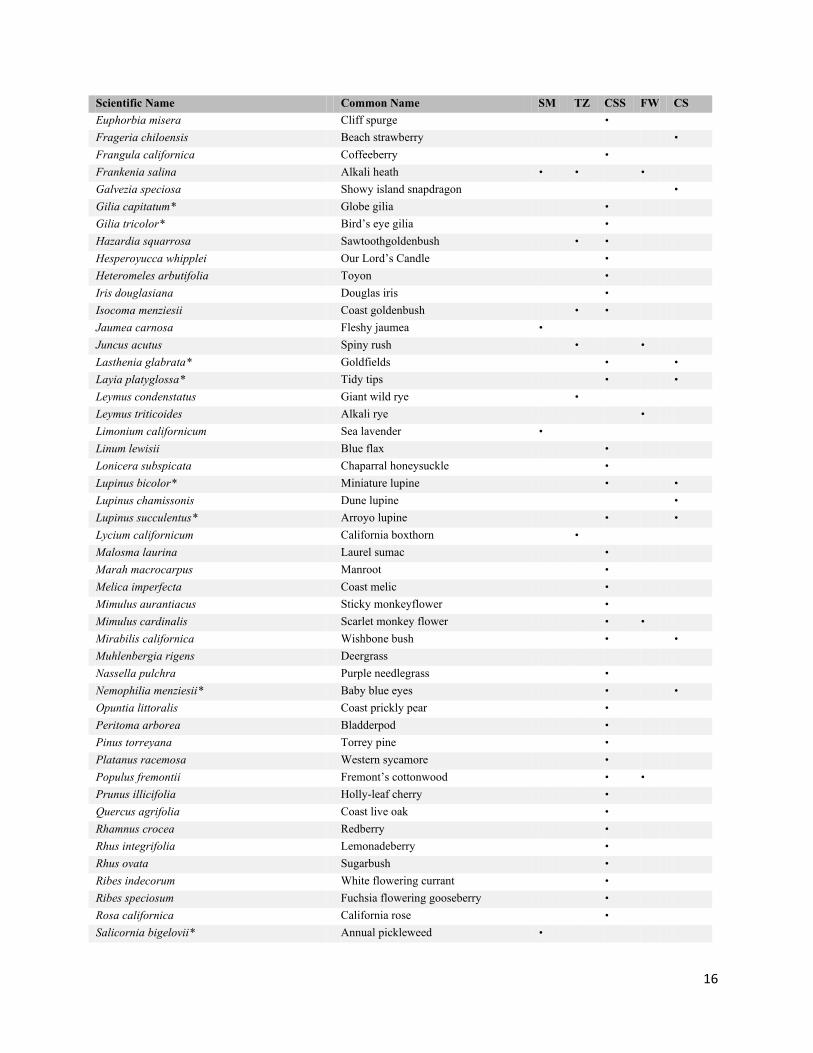
16
Scientific Name Common Name SM TZ CSS FW CS Euphorbia misera Cliff spurge ∙ Frageria chiloensis Beach strawberry ∙ Frangula californica Coffeeberry ∙ Frankenia salina Alkali heath ∙ ∙ ∙ Galvezia speciosa Showy island snapdragon ∙ Gilia capitatum* Globe gilia ∙ Gilia tricolor* Bird’s eye gilia ∙ Hazardia squarrosa Sawtoothgoldenbush ∙ ∙ Hesperoyucca whipplei Our Lord’s Candle ∙ Heteromeles arbutifolia Toyon ∙ Iris douglasiana Douglas iris ∙ Isocoma menziesii Coast goldenbush ∙ ∙ Jaumea carnosa Fleshy jaumea ∙ Juncus acutus Spiny rush ∙ ∙ Lasthenia glabrata* Goldfields ∙ ∙ Layia platyglossa* Tidy tips ∙ ∙ Leymus condenstatus Giant wild rye ∙ Leymus triticoides Alkali rye ∙ Limonium californicum Sea lavender ∙ Linum lewisii Blue flax ∙ Lonicera subspicata Chaparral honeysuckle ∙ Lupinus bicolor* Miniature lupine ∙ ∙ Lupinus chamissonis Dune lupine ∙ Lupinus succulentus* Arroyo lupine ∙ ∙ Lycium californicum California boxthorn ∙ Malosma laurina Laurel sumac ∙ Marah macrocarpus Manroot ∙ Melica imperfecta Coast melic ∙ Mimulus aurantiacus Sticky monkeyflower ∙ Mimulus cardinalis Scarlet monkey flower ∙ ∙ Mirabilis californica Wishbone bush ∙ ∙ Muhlenbergia rigens Deergrass Nassella pulchra Purple needlegrass ∙ Nemophilia menziesii* Baby blue eyes ∙ ∙ Opuntia littoralis Coast prickly pear ∙ Peritoma arborea Bladderpod ∙ Pinus torreyana Torrey pine ∙ Platanus racemosa Western sycamore ∙ Populus fremontii Fremont’s cottonwood ∙ ∙ Prunus illicifolia Holly-leaf cherry ∙ Quercus agrifolia Coast live oak ∙ Rhamnus crocea Redberry ∙ Rhus integrifolia Lemonadeberry ∙ Rhus ovata Sugarbush ∙ Ribes indecorum White flowering currant ∙ Ribes speciosum Fuchsia flowering gooseberry ∙ Rosa californica California rose ∙ Salicornia bigelovii* Annual pickleweed ∙

17
Scientific Name Common Name SM TZ CSS FW CS Salicornia pacifica Common pickleweed ∙ ∙ Salix gooddingii Black willow ∙ ∙ Salix laseolepis Arroyo willow ∙ ∙ Salvia apiana White sage ∙ Salvia leucophylla Purple sage ∙ Salvia mellifera Black sage ∙ Schoenoplectus robustus Giant bulrush ∙ Sisyrinchium bellum Blue-eyed grass ∙ ∙ Spartina foliosa Cordgrass ∙ Spergularia marina Salt spurrey ∙ Sporobolus airoides Alkali dropseed ∙ Suaeda calceoliformis* Horned sea blite ∙ Suaeda esteroa Estuary sea blite ∙ Suaeda taxifolia Woolly sea blite ∙ ∙ Triglochin concinna Arrowgrass ∙ Typha sp. Cattail ∙ Umbellularia californica California laurel ∙ Zostera marina Eelgrass ∙ Abbreviations for habitat types: SM Salt marsh TZ Transition zone CSS Coastal sage scrub FW Freshwater marsh CS Coastal strand
Photo 18: Native plants thriving in the Western Arm’s coastal sage scrub habitat (Graves)
18
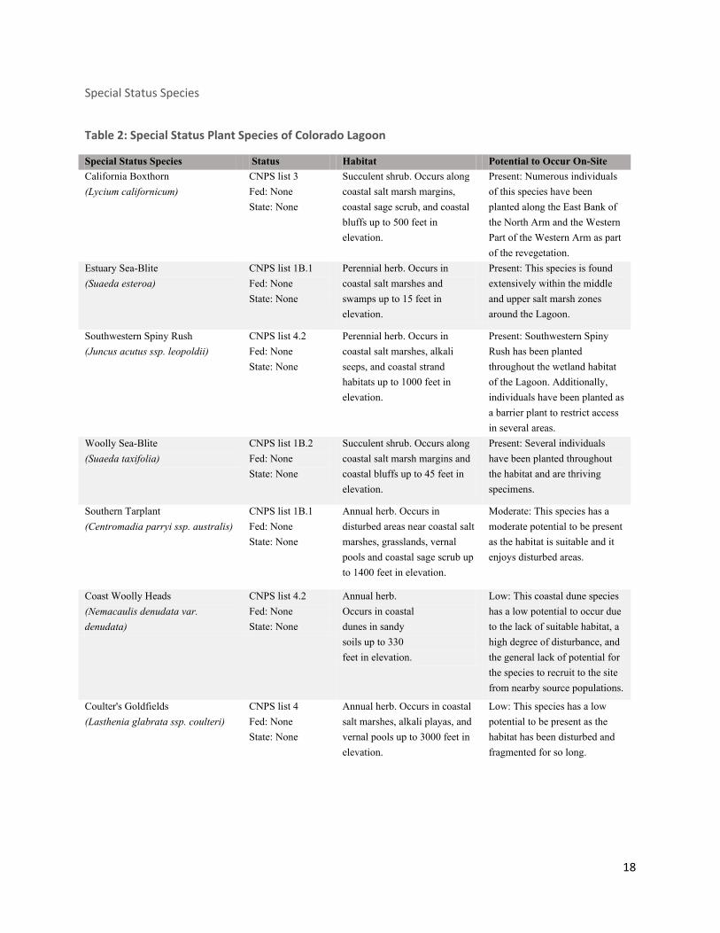
Special Status Species
Table 2: Special Status Plant Species of Colorado Lagoon
Special Status Species Status Habitat Potential to Occur On-Site California Boxthorn (Lycium californicum)
CNPS list 3 Fed: None State: None
Succulent shrub. Occurs along coastal salt marsh margins, coastal sage scrub, and coastal bluffs up to 500 feet in elevation.
Present: Numerous individuals of this species have been planted along the East Bank of the North Arm and the Western Part of the Western Arm as part of the revegetation.
Estuary Sea-Blite (Suaeda esteroa)
CNPS list 1B.1 Fed: None State: None
Perennial herb. Occurs in coastal salt marshes and swamps up to 15 feet in elevation.
Present: This species is found extensively within the middle and upper salt marsh zones around the Lagoon.
Southwestern Spiny Rush (Juncus acutus ssp. leopoldii)
CNPS list 4.2 Fed: None State: None
Perennial herb. Occurs in coastal salt marshes, alkali seeps, and coastal strand habitats up to 1000 feet in elevation.
Present: Southwestern Spiny Rush has been planted throughout the wetland habitat of the Lagoon. Additionally, individuals have been planted as a barrier plant to restrict access in several areas.
Woolly Sea-Blite (Suaeda taxifolia)
CNPS list 1B.2 Fed: None State: None
Succulent shrub. Occurs along coastal salt marsh margins and coastal bluffs up to 45 feet in elevation.
Present: Several individuals have been planted throughout the habitat and are thriving specimens.
Southern Tarplant (Centromadia parryi ssp. australis)
CNPS list 1B.1 Fed: None State: None
Annual herb. Occurs in disturbed areas near coastal salt marshes, grasslands, vernal pools and coastal sage scrub up to 1400 feet in elevation.
Moderate: This species has a moderate potential to be present as the habitat is suitable and it enjoys disturbed areas.
Coast Woolly Heads (Nemacaulis denudata var. denudata)
CNPS list 4.2 Fed: None State: None
Annual herb. Occurs in coastal dunes in sandy soils up to 330 feet in elevation.
Low: This coastal dune species has a low potential to occur due to the lack of suitable habitat, a high degree of disturbance, and the general lack of potential for the species to recruit to the site from nearby source populations.
Coulter's Goldfields (Lasthenia glabrata ssp. coulteri)
CNPS list 4 Fed: None State: None
Annual herb. Occurs in coastal salt marshes, alkali playas, and vernal pools up to 3000 feet in elevation.
Low: This species has a low potential to be present as the habitat has been disturbed and fragmented for so long.

19
Special Status Species Status Habitat Potential to Occur On-Site Coulter's Saltbush (Atriplex coulteri)
CNPS list 1B.1 Fed: None State: None
Perennial herb. Occurs in alkaline or clay soils, open sites, coastal sage scrub, and coastal bluff scrub up to 1500 feet in elevation.
Low: This species is similar in appearance to several present Atriplex species and has a low potential to occur due to the lack of ability to recruit to the site from nearby source populations.
Parish's Brittlescale (Atriplex parishii)
CNPS list 1B.2 Fed: None State: None
Annual Herb. Occurs in alkali playas and vernal pools up to 1000 feet in elevation.
Low: This species has a very low potential to occur due to lack of suitable habitat, high degree of disturbance, and the general lack of potential for species to recruit to the site from nearby source populations.
Prostrate Vernal Pool Navarret (Navarretia prostrata)
CNPS list 1B.1 Fed: None State: None
Annual herb. Occurs in coastal sage scrub and wetland-riparian habitats up to 2296 feet in elevation. Minute, slightly purple inflorescence blooms April through July.
Low: This species has a very low potential to occur due to its rarity and the general lack of potential for species to recruit to the site from nearby source populations.
Salt Marsh Bird's Beak (Chloropyron maritimum ssp. maritimum)
CNPS list 1B.2 Fed: Endangered State: Endangered
Annual herb. Occurs in coastal salt marshes and coastal dunes up to 33 feet in elevation.
Low: This species has low potential to occur within the study area due to habitat fragmentation and disturbance.
San Bernardino Aster (Symphyotrichum defoliatum)
CNPS list 1B.2 Fed: None State: None
Perennial herb. Occurs in freshwater marshes, coastal sage scrub, and southern oak woodland up to 4921 feet in elevation.
Low: This species has a very low potential to occur due to lack of suitable habitat, high degree of disturbance, and the general lack of potential for species to recruit to the site from nearby source populations.
California Orcutt grass (Orcuttia californica)
CNPS list 2.2 Fed: Endangered State: Endangered
Annual herb. Occurs in vernal pools up to 2000 feet in elevation.
Absent: This vernal pool species has a low potential to occur in seasonally ponded areas. This species is not expected to occur due to the lack of suitable habitat, a high degree of disturbance and lack of ability to recruit to the site from nearby source populations.
Lyon's Pentachaeta (Pentachaeta lyonii)
CNPS list 1B.1 Fed: Endangered State: Endangered
Nearly extinct annual herb. Occurs in Chaparral and Valley Grassland habitats. Yellow flower blooms March through August.
Absent: This species has a very low potential to occur due to its rarity and the general lack of potential for species to recruit to the site from nearby source populations.

20
Non-native Plants and Management Techniques
Non-native plants are species that evolved elsewhere and, typically, have been introduced to a region by human actions. Non-native plants, having not evolved in the southern California, are not necessarily bound by the population checks that exist for native plants. For example, a non-native plant may not serve a food source for local fauna, which means impacts of herbivory are lessened or non-existent, giving the non-native plant a potential advantage in the region. Non-native plants have the potential to become invasive, a designation assigned when a particular non-native species dominates area and is detrimental to the function of native habitat. Invasive plants include Carpobrotus edulis (Hottentot-fig), Cynodon dactylon (Bermuda grass), and Pennisetum clandestinum (Kikuyu grass). Non-native plants can serve as habitat for native fauna, but native plants provide superior habitat to native animals, as the various historically occurring species co-evolved. Additionally, several rare animals such as Panoquina errans (Wandering skipper) require a specific native plant - in this case, Distichlis spicata (Salt grass) - to complete their life cycle. In such scenarios, non-native plants are unable to provide habitat to these species of threatened fauna. For these reasons, non-native plant control will likely be the most significant maintenance task in the Western Arm. A restoration ecologist should be consulted to determine non-native control priorities and timelines. Several techniques may be employed to control non-native plant populations. Mulching A thick layer of mulch may deter the germination of non-native seeds contained in the underlying sediment; the unconsolidated nature of mulch also facilitates the easy removal of non-native seedlings that settle into the mulch after its application. Mulch may be purchased or a donation may be available from local tree services. For lower decomposition rates and to extend the time necessary between reapplications, mulch should be woody - not leafy or grassy. Tools useful for this activity are pitchforks, rock rakes, leaf rakes, and gloves. Glasses and a simple breathing mask or bandana are recommended to prevent particulates from being inhaled or irritating eyes. In the Western Arm Reserve, this method is only appropriate for coastal sage scrub habitat. Hand weeding Hand weeding refers to the removal of non-native plants either manually or with the use of a non-motorized tool such as a hoe or small hand tools. In areas with minimal weeding requirements, hand tools are good options. When weeding a large or densely packed non-native patch, action hoeing is a fast and effective means of clearing large areas. The area to be addressed should always be checked for small or recently germinated native plants prior to using an action hoe. Hand weeding, using discretion as to what Pesticide Application As the Colorado Lagoon lies in the coastal zone, any pesticide application must be performed by a professional possessing a Qualified Applicator’s License. The most effective use of pesticide application in the Western Arm Natural Reserve is controlling invasive species that are difficult or impossible to control using manual methods. These species include Carpobrotus edulis (Hottentot fig), Cynodon dactylon (Bermuda grass), and Pennisetum clandestinum (Kikuyu grass). Spraying should not be performed in the intertidal zone. Weed Whacking Weed whacking is a fast method of weed removal, but is not an applicable method in most areas of the Western Arm Natural Area, as weed whacking should only be performed in areas that are covered by exclusively by non-native species. To prevent re-infestation, plants that bear mature or nearly-mature seeds should not be weedwhacked. Extra care should be taken in springtime, as the Western Arm’s fencelines are heavily populated with native annual wildflowers.

21
Solarization Solarization is a technique is which non native weeds are taken down in height to reduce above ground growth. The area to be treated is then covered in thick plastic sheeting. This barrier will trap heat and moisture, and the sun will “cook” seeds and roots of non-native plants. Solarization is most effective during summer months when the sun is most direct. This technique should only be used in areas with no native plant cover in which the desired result is bare ground. Controlled Burns This technique is not appropriate for use at the Colorado Lagoon Specific information on these non-native plant control techniques in specific habitats of the Western Arm Natural Area can be found in the terrestrial habitats section of this document.
Photo 19: Friend of Colorado Lagoon work to maintain Western Arm habitat by installing native plants and removing non-native plants using hand tools (Graves)

22
Table 3: Non-Native Plants of Colorado Lagoon
Scientific Name Common Name Invasive Acacia auriculiformis Earleaf acacia Ailanthus altissma Tree of Heaven ∙∙ Amaranthus deflexus Large fruit amaranth Anagallis arvensis Scarlet pimpernel Asparagus setaceus Common asparagus fern Atriplex prostrata Fat-hen Atriplex semibaccata Australian salt bush ∙∙ Avena barbata Slim oat ∙∙ Bassia hyssopifolia Five-hook bassia ∙ Brassica nigra Black mustard ∙∙ Bromus diandrus Ripgut brome ∙∙ Cakile maritima Sea rocket ∙ Callistemon citrinus Crimson bottlebrush Capsella bursa-pastoris Shepherd's purse Carpobrotus edulis Hottentot-fig ∙∙∙ Chamaesyce maculata Spotted spurge Chenopodium album Lamb's quarters Cinnamomum camphora Camphor tree Cortaderia selloana Pampas grass ∙∙∙ Cotula coronopifolia Brass buttons ∙ Cupaniopsis anacardiodes Carrotwood tree Cynodon dactylon Bermuda grass ∙∙ Ehrharta erecta Panic veldtgrass ∙∙ Erodium cicutarium Common stork's bill ∙ Erythirina caffra Coast coral tree Eucalyptus citriodara Lemon scented gum Eucalyptus ficifolia Red flowering gum Eucalyptus globulus Blue gum Ficus marcophylla Moreton bay fig Foeniculum vulgare Fennel ∙∙∙ Helminthotheca echiodes Bristly ox tongue Hordeum vulgare Common barley Jacaranda mimosifolia Jacaranda Lagunaria patersonii Cow itch tree Limonium ramosissimum Algerian sea lavender ∙ Lolium multiflorum Italian ryegrass ∙∙ Magnolia grandifolia Southern magnolia tree Malva parviflorum Cheeseweed Medicago polymorpha Bur clover ∙ Melilotus alba White sweet clover Melilotus indicus Yellow sweet clover Mesembryanthemum nodiflorum Slender-leaved ice plant Modiola caroliniana Carolina bristlemallow Myoporum laetum Lollypop tree ∙∙ Nassella tenuissima Mexican feathergrass Olea europaea Olive tree ∙ Oxalis pes-caprae Bermuda buttercup ∙∙
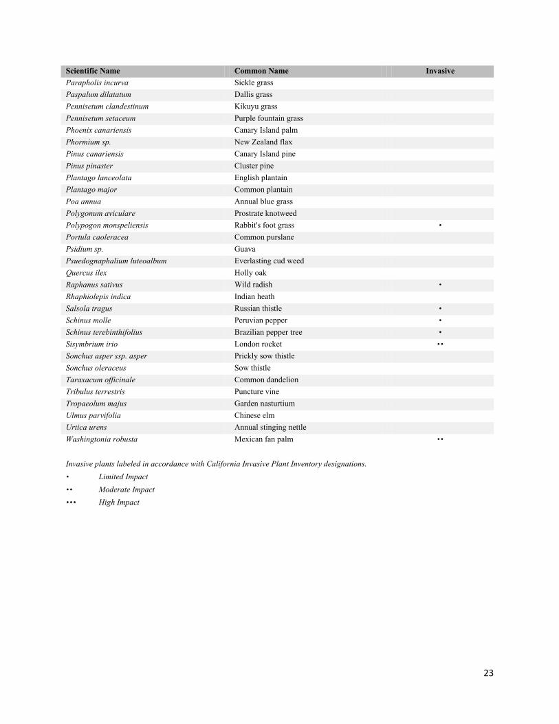
23
Scientific Name Common Name Invasive Parapholis incurva Sickle grass Paspalum dilatatum Dallis grass Pennisetum clandestinum Kikuyu grass Pennisetum setaceum Purple fountain grass Phoenix canariensis Canary Island palm Phormium sp. New Zealand flax Pinus canariensis Canary Island pine Pinus pinaster Cluster pine Plantago lanceolata English plantain Plantago major Common plantain Poa annua Annual blue grass Polygonum aviculare Prostrate knotweed Polypogon monspeliensis Rabbit's foot grass ∙ Portula caoleracea Common purslane Psidium sp. Guava Psuedognaphalium luteoalbum Everlasting cud weed Quercus ilex Holly oak Raphanus sativus Wild radish ∙ Rhaphiolepis indica Indian heath Salsola tragus Russian thistle ∙ Schinus molle Peruvian pepper ∙ Schinus terebinthifolius Brazilian pepper tree ∙ Sisymbrium irio London rocket ∙∙ Sonchus asper ssp. asper Prickly sow thistle Sonchus oleraceus Sow thistle Taraxacum officinale Common dandelion Tribulus terrestris Puncture vine Tropaeolum majus Garden nasturtium Ulmus parvifolia Chinese elm Urtica urens Annual stinging nettle Washingtonia robusta Mexican fan palm ∙∙ Invasive plants labeled in accordance with California Invasive Plant Inventory designations. ∙ Limited Impact ∙∙ Moderate Impact ∙∙∙ High Impact
24
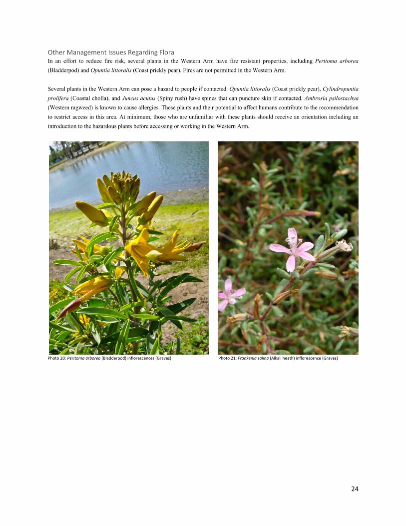
Other Management Issues Regarding Flora In an effort to reduce fire risk, several plants in the Western Arm have fire resistant properties, including Peritoma arborea (Bladderpod) and Opuntia littoralis (Coast prickly pear). Fires are not permitted in the Western Arm. Several plants in the Western Arm can pose a hazard to people if contacted. Opuntia littoralis (Coast prickly pear), Cylindropuntia prolifera (Coastal cholla), and Juncus acutus (Spiny rush) have spines that can puncture skin if contacted. Ambrosia psilostachya (Western ragweed) is known to cause allergies. These plants and their potential to affect humans contribute to the recommendation to restrict access in this area. At minimum, those who are unfamiliar with these plants should receive an orientation including an introduction to the hazardous plants before accessing or working in the Western Arm.
Photo 20: Peritoma arborea (Bladderpod) inflorescences (Graves) Photo 21: Frankenia salina (Alkali heath) inflorescence (Graves)
25
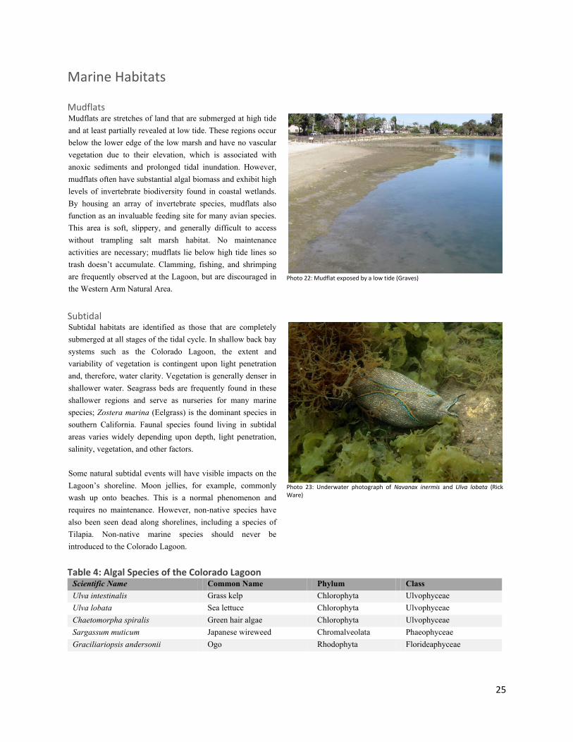
Marine Habitats Mudflats Mudflats are stretches of land that are submerged at high tide and at least partially revealed at low tide. These regions occur below the lower edge of the low marsh and have no vascular vegetation due to their elevation, which is associated with anoxic sediments and prolonged tidal inundation. However, mudflats often have substantial algal biomass and exhibit high levels of invertebrate biodiversity found in coastal wetlands. By housing an array of invertebrate species, mudflats also function as an invaluable feeding site for many avian species. This area is soft, slippery, and generally difficult to access without trampling salt marsh habitat. No maintenance activities are necessary; mudflats lie below high tide lines so trash doesn’t accumulate. Clamming, fishing, and shrimping are frequently observed at the Lagoon, but are discouraged in the Western Arm Natural Area.
Photo 22: Mudflat exposed by a low tide (Graves)
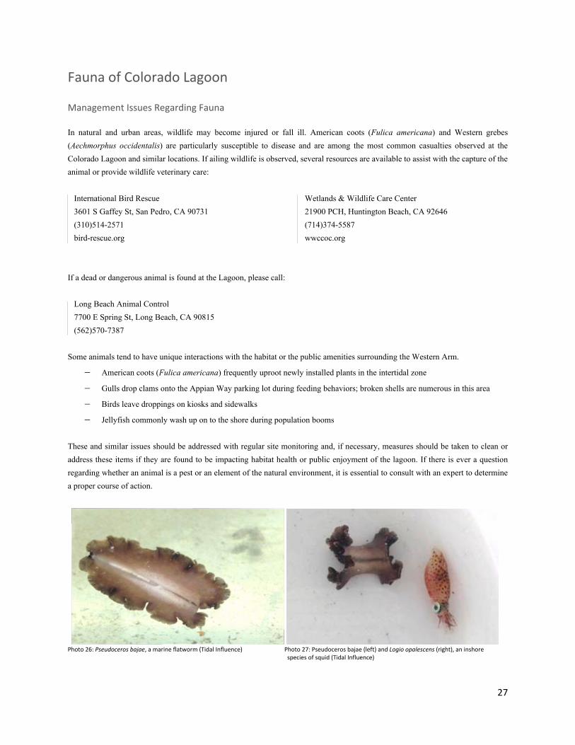
Subtidal Subtidal habitats are identified as those that are completely submerged at all stages of the tidal cycle. In shallow back bay systems such as the Colorado Lagoon, the extent and variability of vegetation is contingent upon light penetration and, therefore, water clarity. Vegetation is generally denser in shallower water. Seagrass beds are frequently found in these shallower regions and serve as nurseries for many marine species; Zostera marina (Eelgrass) is the dominant species in southern California. Faunal species found living in subtidal areas varies widely depending upon depth, light penetration, salinity, vegetation, and other factors. Some natural subtidal events will have visible impacts on the Lagoon’s shoreline. Moon jellies, for example, commonly wash up onto beaches. This is a normal phenomenon and requires no maintenance. However, non-native species have also been seen dead along shorelines, including a species of Tilapia. Non-native marine species should never be introduced to the Colorado Lagoon.
Photo 23: Underwater photograph of Navanax inermis and Ulva lobata (Rick Ware)
Table 4: Algal Species of the Colorado Lagoon Scientific Name Common Name Phylum Class Ulva intestinalis Grass kelp Chlorophyta Ulvophyceae Ulva lobata Sea lettuce Chlorophyta Ulvophyceae Chaetomorpha spiralis Green hair algae Chlorophyta Ulvophyceae Sargassum muticum Japanese wireweed Chromalveolata Phaeophyceae Graciliariopsis andersonii Ogo Rhodophyta Florideaphyceae

26
Water Quality Trash will be long-term management task requiring regular monitoring and maintenance. To aid in the ease of clean ups, several trash control measures exist in the Western Arm and elsewhere in the Colorado Lagoon. Fences and perimeter plants have been placed in strategic locations to catch windblown trash. These fencelines should be checked regularly and any loose trash should be disposed of in public trash cans. Three trash separation devices have been installed on drains that empty into the Colorado Lagoon during high-rainfall and flood events. These devices are located outside the boundary of the Western Arm and are maintained by City of Long Beach contractors. Due to enduring tidal restrictions, algal blooms may occur during times of high rainfall and high temperature. During seasonally large algal blooms, dissolved oxygen levels should be measured to determine if algae is affecting ecosystem health. Algae should not be removed from the Western Arm Natural Area because:
− Algae does not present a public health issue
− Decomposition of algae deposits nutrients vital to salt marsh growth
− Entering the salt marsh and mudflats to remove algae creates more of an impact than the algae itself does
− It is an inefficient use of resources; the algae will return to the salt marsh at the next high tide
− Algae serves as cover for salt marsh fish and invertebrates, creating important microhabitats
Special Topic: Eelgrass Beds
Eelgrass beds are found throughout Alamitos Bay, but some of the healthiest beds are located near the lagoon in Marine Stadium. Colorado Lagoon contains a few small patches, but would provide excellent eelgrass habitat if the water was clearer, the tidal range was increased, and deeper areas were raised in elevation and made shallower. A recent investigation by Rick Ware of Coastal Resources Management determined that, in its current state, the Western Arm cannot support high quality eelgrass habitat due to steep subtidal slopes and an over abundance of algae. Plans are in motion to change these conditions so that the Lagoon will become a haven for this aquatic angiosperm.
Photo 24: Photo of eelgrass growing in the Colorado Lagoon (Rick Ware)
Photo 25: Algae on a mudflat (Graves)
27
Fauna of Colorado Lagoon Management Issues Regarding Fauna In natural and urban areas, wildlife may become injured or fall ill. American coots (Fulica americana) and Western grebes (Aechmorphus occidentalis) are particularly susceptible to disease and are among the most common casualties observed at the Colorado Lagoon and similar locations. If ailing wildlife is observed, several resources are available to assist with the capture of the animal or provide wildlife veterinary care: International Bird Rescue 3601 S Gaffey St, San Pedro, CA 90731 (310)514-2571 bird-rescue.org
Wetlands & Wildlife Care Center 21900 PCH, Huntington Beach, CA 92646 (714)374-5587 wwccoc.org
If a dead or dangerous animal is found at the Lagoon, please call: Long Beach Animal Control 7700 E Spring St, Long Beach, CA 90815 (562)570-7387 Some animals tend to have unique interactions with the habitat or the public amenities surrounding the Western Arm.
− American coots (Fulica americana) frequently uproot newly installed plants in the intertidal zone
− Gulls drop clams onto the Appian Way parking lot during feeding behaviors; broken shells are numerous in this area
− Birds leave droppings on kiosks and sidewalks
− Jellyfish commonly wash up on to the shore during population booms
These and similar issues should be addressed with regular site monitoring and, if necessary, measures should be taken to clean or address these items if they are found to be impacting habitat health or public enjoyment of the lagoon. If there is ever a question regarding whether an animal is a pest or an element of the natural environment, it is essential to consult with an expert to determine a proper course of action.
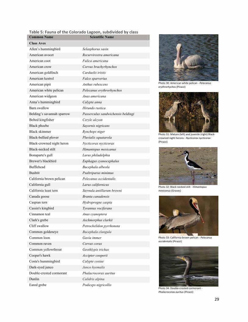
Photo 26: Pseudoceros bajae, a marine flatworm (Tidal Influence) Photo 27: Pseudoceros bajae (left) and Logio opalescens (right), an inshore
species of squid (Tidal Influence)

28
Special Topic: Maintaining Specialized Habitats Relatively few reptiles and amphibians are found at Colorado Lagoon (Table 5); efforts must therefore be made to conserve and enhance these small populations. These shy creatures benefit coastal communities by controlling plant pest populations and providing a food source to native mesopredators. Unfortunately, herpetafauna (lizards, snakes, frogs, toads, and salamanders) are favorite treats of housecats and urban birds that also hunt in the upland plant communities. These animals need proper shelter in order to escape predation. To accommodate these species, large flat rocks, boulders, pieces of concrete, and wood have been spread throughout the coastal sage scrub habitat areas. This debris should be maintained on site in an attractive manner. Seasonal surveys for herpetafauna will indicate how to best provide for the existing populations. Many flowering species of plant serve as a nectaring source for butterflies and other native pollinators. Habitat is scarce for several of these insects, and improper maintenance techniques can negatively impact their populations. Insecticides should not be used on nectaring plants, as pollinating insect populations are desirable in the Western Arm habitats. Larvae in particular will be extremely sensitive to pesticides and other chemicals.
Photo 28: Western fence lizard (Sceloporus occidentalis) basking on a rock (Zahn)
Photo 29: Honey bee pollinating the flower of a California bush sunflower - Encelia californica (Tidal Influence)
29
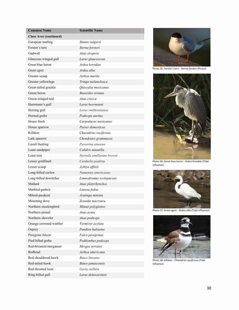
Table 5: Fauna of the Colorado Lagoon, subdivided by class Common Name Scientific Name
Allen’s hummingbird Selasphorus sasin American avocet Recurvirostra americana American coot Fulica americana American crow Corvus brachyrhynchos American goldfinch Carduelis tristis American kestrel Falco sparverius American pipit Anthus rubescens American white pelican Pelecanus erythrorhynchos American widgeon Anas americana Anna’s hummingbird Calypte anna Barn swallow Hirundo rustica Belding’s savannah sparrow Passerculus sandwichensis beldingi Belted kingfisher Ceryle alcyon Black phoebe Sayornis nigricans Black skimmer Rynchops niger Black-bellied plover Pluvialis squatarola Black-crowned night heron Nycticorax nycticorax Black-necked stilt Himantopus mexicanus Bonaparte's gull Larus philadelphia Brewer's blackbird Euphagus cyanocephalus Bufflehead Bucephala albeola Bushtit Psaltriparus minimus California brown pelican Pelecanus occidentalis California gull Larus californicus California least tern Sternula antillarum browni Canada goose Branta canadensis Caspian tern Hydroprogne caspia Cassin's kingbird Tyrannus vociferans Cinnamon teal Anas cyanoptera Clark's grebe Aechmorphus clarkii Cliff swallow Petrochelidon pyrrhonota Common goldeneye Bucephala clangula Common loon Gavia immer Common raven Corvus corax Common yellowthroat Geothlypis trichas Cooper's hawk Accipter cooperii Costa's hummingbird Calypte costae Dark-eyed junco Junco hyemalis Double-crested cormorant Phalacrocorax auritus Dunlin Calidris alpina Eared grebe Podiceps nigricollis
Class Aves
Photo 30: American white pelican - Pelecanus erythrorhychos (Pirazzi)
Photo 31: Mature (left) and juvenile (right) Black-crowned night herons - Nycticorax nycticorax (Pirazzi)
Photo 32: Black-necked stilt - Himantopus mexicanus (Graves)
Photo 33: California brown pelican - Pelecanus occidentalis (Pirazzi)
Photo 34: Double-crested cormorant - Phalacrocorax auritus (Pirazzi)
30
Common Name Scientific Name
European starling Stunus vulgaris Forster’s tern Sterna forsteri Gadwall Anas strepera Glaucous-winged gull Larus glaucescens Great blue heron Ardea herodias Great egret Ardea alba Greater scaup Aythya marila Greater yellowlegs Tringa melanoleuca Great-tailed grackle Quiscalus mexicanus Green heron Butorides striatus Green-winged teal Anas crecca Heermann’s gull Larus heermanni Herring gull Larus smithsonianus Horned grebe Podiceps auritus House finch Carpodacus mexicanus House sparrow Passer domesticus Killdeer Charadrius vociferous Lark sparrow Chondestes grammacus Lazuli bunting Passerina amoena Least sandpiper Calidris minutilla Least tern Sternula antillarum browni Lesser goldfinch Carduelis psaltria Lesser scaup Aythya affinis Long-billed curlew Numenius americanus Long-billed dowitcher Limnodromus scolopaceus Mallard Anas platyrhynchos Marbled godwit Limosa fedoa Mitred parakeet Aratinga mitrata Mourning dove Zenaida macroura Northern mockingbird Mimus polyglottos Northern pintail Anas acuta Northern shoveler Anas podiceps Orange-crowned warbler Vermivor acelata Osprey Pandion haliaetus Peregrine falcon Falco peregrinus Pied billed grebe Podilymbus podiceps Red-breasted merganser Mergus serrator Redhead Aythya americana Red-shouldered hawk Buteo lineatus Red-tailed hawk Buteo jamaicensis Red-throated loon Gavia stellata Ring-billed gull Larus delawarensis
Class Aves (continued)
Photo 35: Forster’s tern - Sterna forsteri (Pirazzi)
Photo 36: Great blue heron - Ardea herodias (Tidal Influence)
Photo 37: Great egret - Ardea alba (Tidal Influence)
Photo 38: Killdeer - Charadrius vociferous (Tidal Influence)

31
Common Name Scientific Name
Rock dove (Common pigeon) Columbia livia Ross's goose Chen rossii Ruby-crowned kinglet Regulus calendula Ruddy duck Oxyurajamaicensis Sanderling Calidris alba Say’s phoebe Sayornis saya Semipalmated plover Charadrius semipalmatus Short-billed dowitcher Limnodromus griseus Snowy egret Egretta thula Song sparrow Melospizza melodia Spotted sandpiper Actitis macularia Surf scoter Melanittaper spicillata Tropical kingbird Tyrannus melancholicus Turkey vulture Cathartes aura Western bluebird Sialia mexicana Western grebe Aechmorphus occidentalis Western gull Larus occidentalis Western kingbird Tyrannus verticalis Western meadowlark Sturnella neglecta Western sandpiper Calidris mauri Western scrubjay Aphelocoma californica Wood duck Aix sponsa Whimbrel Numenius phaeopus White-crowned sparrow Zonotrichia leucophrys White-faced ibis Plegadis chihi Willet Tringa semipalmatus Yellow-rumped warbler Dendroica coronata
Class Aves (continued)
Class Mammalia Virginia opossum Didelphis virginiana Eastern fox squirrel Sciurus niger Botta’s pocket gopher Thomomys bottae Domestic cat Felis catus Domestic dog Canis lupus familiaris Coyote Canis latrans Striped skunk Mephitis mephitis Raccoon Procyon lotor House rat Rattus rattus
Class Reptilia Western fence lizard Sceloporus occidentalis Southern alligator lizard Elgaria multicarinata
Class Insecta Insect Larvae Chironomidae larvae
Photo 39: Red-tailed hawk - Buteo lineatus (Pirazzi)
Photo 40: Snowy egret - Egretta thula (Pirazzi)
Photo 41: White-crowned sparrow - Zonotrichia leucophrys (Tidal Influence)
Photo 42: Coyote pawprint – Canis latrans (Tidal Influence)
Photo 43: Western fence lizard – Sceloporus occidentalis (Tidal Influence)
32
Common Name Scientific Name
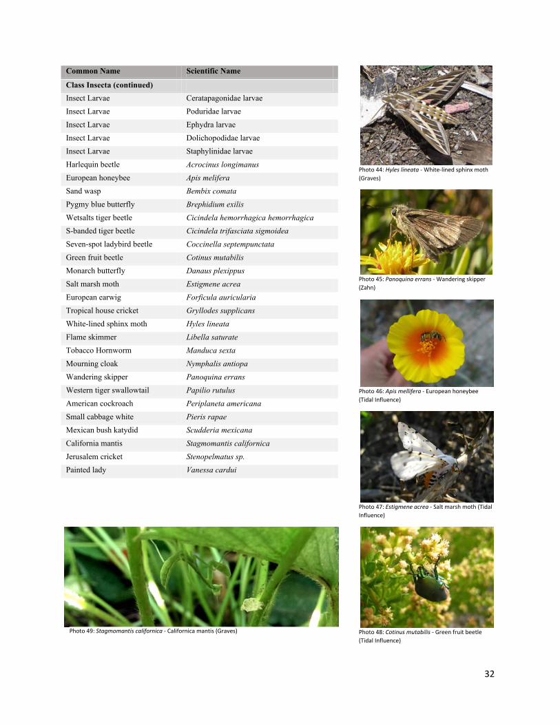
Class Insecta (continued) Insect Larvae Ceratapagonidae larvae Insect Larvae Poduridae larvae Insect Larvae Ephydra larvae Insect Larvae Dolichopodidae larvae Insect Larvae Staphylinidae larvae Harlequin beetle Acrocinus longimanus European honeybee Apis melifera Sand wasp Bembix comata Pygmy blue butterfly Brephidium exilis Wetsalts tiger beetle Cicindela hemorrhagica hemorrhagica S-banded tiger beetle Cicindela trifasciata sigmoidea Seven-spot ladybird beetle Coccinella septempunctata Green fruit beetle Cotinus mutabilis Monarch butterfly Danaus plexippus Salt marsh moth Estigmene acrea European earwig Forficula auricularia Tropical house cricket Gryllodes supplicans White-lined sphinx moth Hyles lineata Flame skimmer Libella saturate Tobacco Hornworm Manduca sexta Mourning cloak Nymphalis antiopa Wandering skipper Panoquina errans Western tiger swallowtail Papilio rutulus American cockroach Periplaneta americana Small cabbage white Pieris rapae Mexican bush katydid Scudderia mexicana California mantis Stagmomantis californica Jerusalem cricket Stenopelmatus sp. Painted lady Vanessa cardui
Photo 44: Hyles lineata - White-lined sphinx moth (Graves)
Photo 45: Panoquina errans - Wandering skipper (Zahn)
Photo 46: Apis mellifera - European honeybee (Tidal Influence)
Photo 47: Estigmene acrea - Salt marsh moth (Tidal Influence)
Photo 48: Cotinus mutabilis - Green fruit beetle (Tidal Influence)
Photo 49: Stagmomantis californica - Californica mantis (Graves)

33
Table 6: Marine Species of Colorado Lagoon Common Name Scientific Name Class Phylum Porifera Yellow tube sponge Aplysina fistularis Demospongiae White sponge Leucosolenia sp. Calarea
Phylum Bryozoa Spiral bryozoan Bugula californica Gymnolaemata Spaghetti bryozoan Zoobotryon verticillatum Gymnolaemata
Phylum Platyhelminthes Flatworm Pseudoceros bajae Turbellaria
Phylum Cnidaria White hydroid Corymorpha palma Hydrozoa Moon jelly Aurelia aurita Scyphzoa
Phylum Mollusca File limpet Acmaea limatula Gastropoda Ribbed limpet Acmaea scabra Gastropoda Paper bubble shell Acteocina carinata Gastropoda Rude barrel-bubble Acteocina inculta Gastropoda Carinate dove shell Alia carinata Gastropoda California sea hare Aplysia californica Gastropoda Salt marsh snail Assiminea californica Gastropoda Cloudy bubble snail Bulla gouldiana Gastropoda California horn snail Cerithidia californica Gastropoda Ringed dorid nudibranch Diaulula sandiegensis Gastropoda Striped sea hare Navanax inermis Gastropoda Smooth cockle Chione fluctifraga Bivalvia Wavy cockle Chione undatella Bivalvia Yellow cockle Laevicardium elatum Bivalvia Quahog clam Mercenaria mercenaria Bivalvia Asian mussel Musculista senhousia Bivalvia Bay mussel Mytilus edulis Bivalvia Mediterranean mussel Mytilus galloprovincialis Bivalvia Littleneck clam Protothaca staminea Bivalvia Jack-knife clam Tagelus californicus Bivalvia Olympia oyster Ostrea lurida Bivalvia Manila clam Venerupis philippinarum Bivalvia Opalescent inshore squid Loligo opalescens Cephalopoda Two-spotted octopus Octopus bimaculoides Cephalopoda
Phylum Nemertea Ribbon worm Rhamphogordius sanguineus Anopla
Phylum Annelida Polychaete worm Paranais litoralis Clitellata Polychaete worm Pseudopolydora
paucibranchiata Polychaeta
Photo 50: Aplysina fistularis (Ware)
Photo 51: Aurelia aurita (Ware)
Photo 52: Bulla gouldiana (Ware)
Photo 53: Dialula sandiegensis (Ware)
Photo 54: Loligo opalescens (Tidal Influence)

34
Phylum Annelida (cont.) Polychaete worm Polydora ligni Polychaeta Polychaete worm Polydora nuchalis Polychaeta Polychaete worm Streblospio benedicti Polychaeta Polychaete worm Spiophanes duplex Polychaeta Polychaete worm Spiophanes sp. Polychaeta Polychaete worm Spionidae Polychaeta Polychaete worm Capitella capitata Polychaeta Polychaete worm Cirraformia spirabrancha Polychaeta Polychaete worm Nephtyidae Polychaeta Polychaete worm Lysaretidae Polychaeta Polychaete worm Paraonidae Polychaeta Polychaete worm Opheliidae Polychaeta Polychaete worm Eteone californica Polychaeta
Phylum Arthropoda Amphipod Monocorophium sp. Malacostraca Amphipod Grandidierella japonica Malacostraca Amphipod Gammaridea Malacostraca Tanaidacean Leptochelia dubia Malacostraca Purple shore crab Hemigrapsus nudus Malacostraca Red ghost shrimp Neotrypaea californiensis Malacostraca Yellow shore crab Hemigrapsus oregonensis Malacostraca Striped shore crab Pachygrapsus crassipes Malacostraca Small acorn barnacle Chthamalus fissus Maxillopoda
Phylum Echinodermata Ochre star Pisaster ochraceus Asteroidea
Phylum Chordata Stalked tunicate Styela montereyensis Tunicata Brain tunicate Styela plicata Tunicata
Vase tunicate Ciona intestinalis Tunicata
Bat ray Myliobatis californicus Chondrichthyes
Electric ray Torpedo californica Chondrichthyes
Gray smoothhound Mustelus californicus Chondrichthyes
Round sting ray Urobatis haleri Chondrichthyes
Shovelnose guitarfish Rhinobatus productus Chondrichthyes
Thornback ray Raja clavata Chondrichthyes Shiner surf perch Cymatogaster aggregata Actinopterygii Black surf perch Embiotoca jacksoni Actinopterygii Barred sand bass Paralabrax nebulifer Actinopterygii Arrow goby Clevelandia ios Actinopterygii Bay pipe fish Syngnathus griseolineatus Actinopterygii California halibut Paralichthys californicus Actinopterygii California killifish Fundulus parvipinnis Actinopterygii Diamond turbot Hypsopsetta guttulata Actinopterygii
Photo 55: Octopus bimaculoides (Tidal Influence)
Photo 56: Ciona intestinalis (Ware)
Photo 57: Navanax inermis (Ware)
Photo 58: Ostrea lurida (Ware)
Photo 59: Aplysia californica (Ware)
35
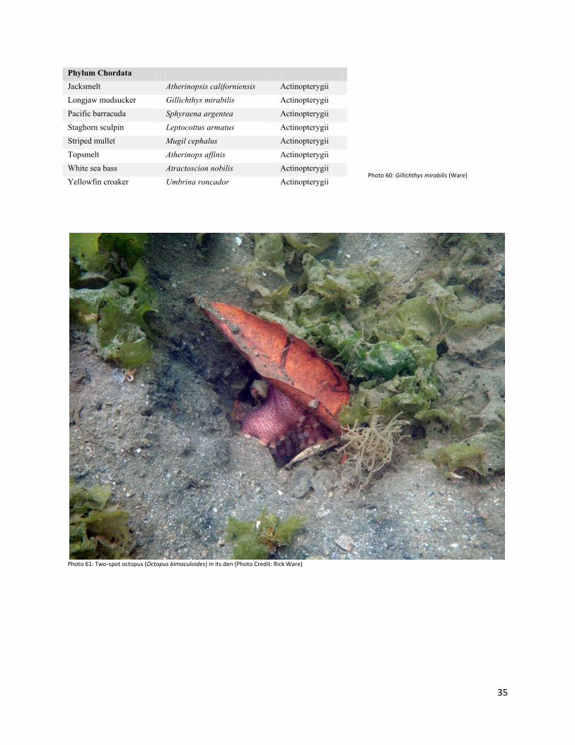
Phylum Chordata Jacksmelt Atherinopsis californiensis Actinopterygii Longjaw mudsucker Gillichthys mirabilis Actinopterygii Pacific barracuda Sphyraena argentea Actinopterygii Staghorn sculpin Leptocottus armatus Actinopterygii Striped mullet Mugil cephalus Actinopterygii Topsmelt Atherinops affinis Actinopterygii White sea bass Atractoscion nobilis Actinopterygii Yellowfin croaker Umbrina roncador Actinopterygii
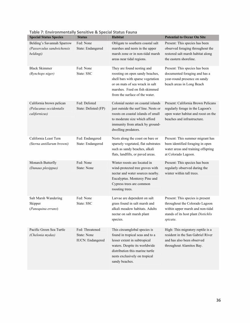
Photo 61: Two-spot octopus (Octopus bimaculoides) in its den (Photo Credit: Rick Ware)
Photo 60: Gillichthys mirabilis (Ware)
36
Table 7: Environmentally Sensitive & Special Status Fauna Special Status Species Status Habitat Potential to Occur On Site
Belding’s Savannah Sparrow (Passerculus sandwichensis beldingi)
Fed: None State: Endangered
Obligate to southern coastal salt marshes and nests in the upper marsh zone or in non-tidal marsh areas near tidal regions.
Present: This species has been observed foraging throughout the restored salt marsh habitat along the eastern shoreline.
Black Skimmer (Rynchops niger)
Fed: None State: SSC
They are found nesting and roosting on open sandy beaches, shell bars with sparse vegetation or on mats of sea wrack in salt marshes. Feed on fish skimmed from the surface of the water.
Present: This species has been documented foraging and has a year-round presence on sandy beach areas in Long Beach
California brown pelican (Pelacanus occidentalis californicus)
Fed: Delisted State: Delisted (FP)
Colonial nester on coastal islands just outside the surf line. Nests or roosts on coastal islands of small to moderate size which afford immunity from attack by ground-dwelling predators.
Present: California Brown Pelicans regularly forage in the Lagoon's open water habitat and roost on the beaches and infrastructure.
California Least Tern (Sterna antillarum browni)
Fed: Endangered State: Endangered
Nests along the coast on bare or sparsely vegetated, flat substrates such as sandy beaches, alkali flats, landfills, or paved areas.
Present: This summer migrant has been identified foraging in open water areas and training offspring at Colorado Lagoon.
Monarch Butterfly (Danaus plexippus)
Fed: None State: None
Winter roosts are located in wind-protected tree groves with nectar and water sources nearby. Eucalyptus. Monterey Pine and Cypress trees are common roosting trees.
Present: This species has been regularly observed during the winter within tall trees.
Salt Marsh Wandering Skipper (Panoquina errans)
Fed: None State: SSC
Larvae are dependent on salt grass found in salt marsh and alkali meadow habitats. Adults nectar on salt marsh plant species.
Present: This species is present throughout the Colorado Lagoon within upper marsh and non-tidal stands of its host plant Distichlis spicata.
Pacific Green Sea Turtle (Chelonia mydas)
Fed: Threatened State: None IUCN: Endangered
This circumglobal species is found in tropical seas and to a lesser extent in subtropical waters. Despite its worldwide distribution this marine turtle nests exclusively on tropical sandy beaches.
High: This migratory reptile is a resident in the San Gabriel River and has also been observed throughout Alamitos Bay.

37
Special Status Species Status Habitat Potential to Occur On Site
Salt Marsh Tiger Beetles (Cicindella hemorrhagica hemorrhagica)
Fed: None State: None
This predatory beetle inhabits salt marshes, mudflats and salt pannes where they make burrows in the intertidal zone.
High: This species has been documented on tidal mudflats around the Colorado Lagoon.
S-Banded Tiger Beetles (Cicindella trifasciata sigmoides)
Fed: None State: None
This predatory beetle inhabits salt marshes, mudflats and salt pannes where they make burrows in the intertidal zone.
High: This species has been documented on tidal mudflats around the Colorado Lagoon.
Western Snowy Plover (Charadrius alexandrines nivosus)
Fed: Threatened State: SSC
This species occurs on sandy beaches, salt pond levees and along the shores of large alkali lakes. It needs sandy or gravelly substrates for nesting.
High: This is a regular foraging and loafing species within nearby coastal salt marshes like Los Cerritos Wetlands. This species has not been positively identified making use of habitat at Colorado Lagoon. However, there is a high potential for this species to be present due to correct habitat type.
Big Free-tailed Bat (Nyctinomops macrotis)
Fed: None State: SSC
Day roosts in caves, crevices, and occasionally hollow trees. Forages in grasslands, shrublands, woodlands, and forest in western North America.
Low: While suitable foraging exists in the project area's vicinity, day and night roosting opportunities are limited.
Coast Horned Lizard (Phrynosoma blainvillii)
Fed: None State: SSC
Occurs in coastal valley, foothill, scrub and riparian habitats. Feeds primarily on the native harvester ant.
Low: There is a low potential for the presence of this reptile because the food source for this species is not abundant due to the urbanization influenced invasion of the Argentine ant.
Pacific Pocket Mouse (Perognathus longimembris pacificus)
Fed: Endangered State: None
Occupies loose sandy soils supporting sparse coastal sage scrub, non-native grassland, and ruderal habitats.
Low: This species has a low potential to occur due to severe habitat disturbance and fragmentation.
Sandy Beach Tiger Beetle (Cicindela hirticollis gravida)
Fed: None State: None
Inhabits areas adjacent to non-brackish water along the coast of California from San Francisco bay to northern Mexico. Clean, dry, light-colored sand in the upper zone. Subterranean larvae prefer moist sand not affected by wave action.
Low: FOCL documented use of the area by two other species of Tiger Beetle: C. trifasciata sigmoidea and C. hemorrhagica hemorrhagica. Other species may be present in the areas

38
Special Status Species Status Habitat Potential to Occur On Site
Silver-haired Bat (Lasionycteris noctivagans)
Fed: None State: SSC
Primarily a coastal and montane forest dweller feeding over streams, ponds and open brush. Roosts in hollow trees beneath exfoliating bark and abandoned woodpecker holes. This species needs drinking water.
Low: While suitable foraging exists in the project area's vicinity, day and night roosting opportunities are limited.
Western Beach Tiger Beetle (Cicindelalate signatalate signata)
Fed: None State: None
Inhabits mudflats and beaches in Coastal southern California
Low: FOCL documented use of the area by two other species of Tiger Beetle: C. trifasciata sigmoidea and C. hemorrhagica hemorrhagica. Other species may be present in the areas
Western Tidal-Flat Tiger Beetle (Cicindela gabbii)
Fed: None State: None
Inhabits marine shoreline within central California and southern California.
Low: FOCL documented use of the area by two other species of Tiger Beetle: C. trifasciata sigmoidea and C. hemorrhagica hemorrhagica. Other species may be present in the area.
Bank Swallow (Riparia riparia)
Fed: None State: Threatened
The Bank Swallow nests in colonies in streamside banks across much of North America.
Absent: Habitat in the area is not suitable for foraging or nesting.
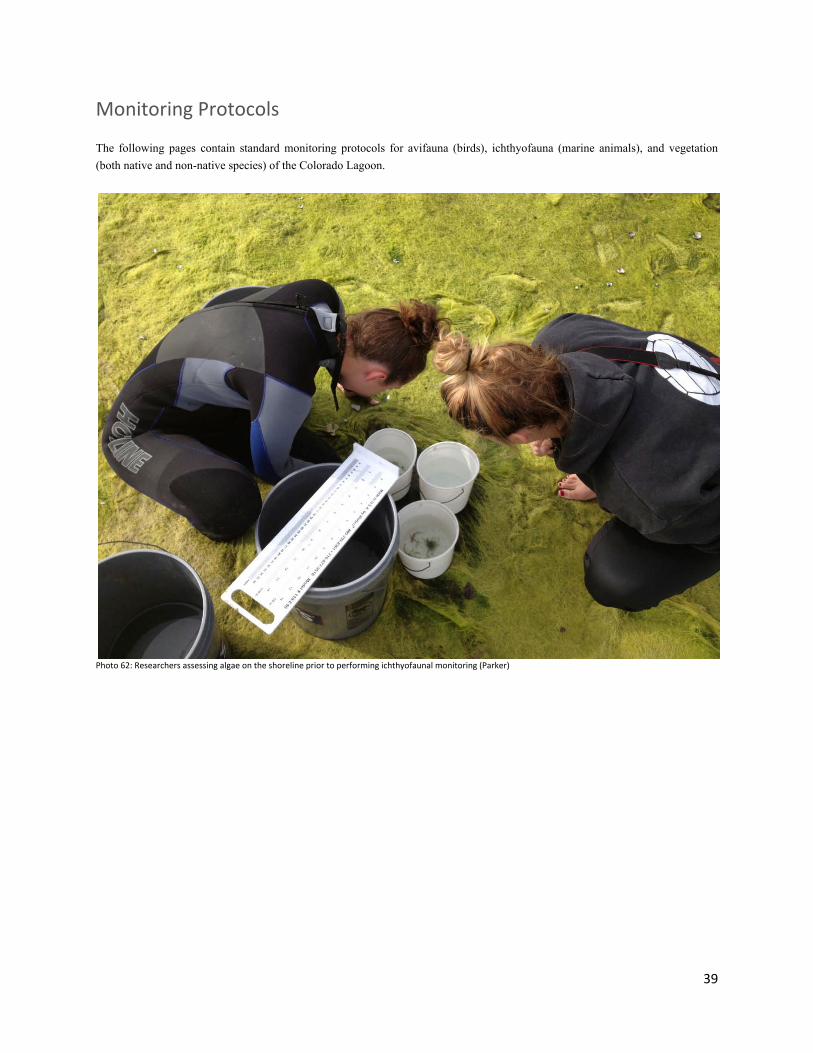
39
Monitoring Protocols The following pages contain standard monitoring protocols for avifauna (birds), ichthyofauna (marine animals), and vegetation (both native and non-native species) of the Colorado Lagoon.
Photo 62: Researchers assessing algae on the shoreline prior to performing ichthyofaunal monitoring (Parker)

40
Standard Procedures for Vegetation Monitoring Materials and Methods
1. Collect materials (2 pencils, 1 clipboard, 1 rubber band, hard copy of previous month’s data, 6 blank data sheets, 1 square meter quadrat, 1 transect tape, 1 camera, 1 meter stick
2. Fill out top portion of “Colorado Lagoon Vegetation
Field Sampling Data Sheet”
3. At the first transect in the Western Arm, extend transect
tape down to 1m past the last quadrat marker. Align the transect tape so that it touches both PVC pipe markers (Photo 63).
4. Take 2 pictures - 1 landscape and 1 portrait (Photo 64,
65) – from the top of the transect facing the water.
5. While facing the transect tape, place the PVC quadrat
square on the ground with the quadrat marker (PVC pipe) resting in the bottom left hand corner of the quadrat (Photo 66).
6. On the data sheet, fill out the Transect #, Quad #, and
Habitat column.
Photo 63: Step 3 (Tidal Influence)
Photo 64: Step 4 (Tidal Influence)
Photo 65: Step 4 (Tidal Influence)
Photo 66: Step 5 (Tidal Influence)
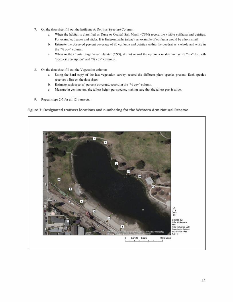
41
7. On the data sheet fill out the Epifauna & Detritus Structure Column: a. When the habitat is classified as Dune or Coastal Salt Marsh (CSM) record the visible epifauna and detritus.
For example, Leaves and sticks, E is Enteromorpha (algae); an example of epifauna would be a horn snail. b. Estimate the observed percent coverage of all epifauna and detritus within the quadrat as a whole and write in
the “% cov” column. c. When in the Coastal Sage Scrub Habitat (CSS), do not record the epifauna or detritus. Write “n/a” for both
“species/ description” and “% cov” columns.
8. On the data sheet fill out the Vegetation column:
a. Using the hard copy of the last vegetation survey, record the different plant species present. Each species receives a line on the data sheet.
b. Estimate each species’ percent coverage, record in the “% cov” column. c. Measure in centimeters, the tallest height per species, making sure that the tallest part is alive.
9. Repeat steps 2-7 for all 12 transects.
Figure 3: Designated transect locations and numbering for the Western Arm Natural Reserve

42
Colorado Lagoon Vegetation Field Sampling Data Sheet
Colorado Lagoon Vegetation Field Sampling Data Sheet Page 1
Sampling Date: Observers: Tidal Height:Start Time: Site: Up or Down:End Time: Weather: Human Activity:
Trans Quad Habitat1-12 # CSS,DUNE,CSM Species or Description % cov Species %cov Plant heights (cm)
Epifauna & Detritus Structure Vegetation* Notes:

43
Standard Operating Procedures for Avifauna Monitoring
Table 8: Avian Behavioral Actions
Table 9: Avian Habitat Usage
Habitat Description
A
Artificial - Telephone poles, fences, buildings
F Flying
U Uplands - Area above mudflats compromising coastal sage scrub, dune or transition zone
W Wetlands - On the mudflats, in the water, or in the coastal salt marsh
Behavior Description
Aquatic feeding
Bird is actively searching for food in the water, or eating
Flight Flying
Ground feeding
Bird is actively searching for food on the ground, pecking at ground
Other Bird is doing a behavior not listed- in notes column indicate behavior (i.e. Mating)
Preening Bird is actively preening its own feathers or another birds
Resting Bird has its head resting on its dorsal side, or under its wing
Seeking in Flight
Bird is flying over area and scanning ground and/ or shrubs
Seeking Standing
Bird is standing and seeking for food in the water or on the ground
Seeking Walking
Bird is actively walking seeking for food in the water or on the ground
Materials and Methods 1. Collect materials: - Writing utensil - Clipboard - Camera - At least two blank data sheets - Pair of binoculars per person - Bird identification booklet 2. Fill out top portion of “Colorado Lagoon Avifauna Field Sample Data Sheet”: - Sampling date - Start Time, End Time - Observers - Site - Weather (general description) - Tidal height - Tidal direction 3. For each survey, walk the full perimeter of the lagoon. 4. Note all bird species, count, behavior, and location on the data sheet (Tables 8 and 9). When multiple birds of the same species are present, count all individuals and their respective behaviors; avoid double counting individual birds.
Photo 67: Red-tailed hawk – Buteo lineatus (Pirazzi)
Photo 68: Clark’s grebe – Aechmophorus clarkii (Pirazzi)

44
Colorado Lagoon Avifauna Field Sampling Data Sheet
Colorado Lagoon Avifauna Field Sampling Data Sheet Page 1
Observers: Tidal Height:Site: Up or Down:
End Time: Weather: Human Activity:
seeking w alking seeking standing seeking in f light ground feeding aquatic feeding
resting flying preening or stretching
other
w etlands (W), uplands (U), artif icial (A),
f lying (F)
1
2
3
4
5
6
7
8
9
10
11
12
13
14
15
16
17
18
Sampling Date:Start Time:
Section Code,Species Name, Count
BehaviorLocation
Notes Foraging Other

45
Standard Procedures for Ichthyofauna Monitoring Materials and Methods
1. Collect materials (2 pencils, 5 blank data sheets, 1 clipboard, 1 rubber band, 3 large buckets, 5 small buckets, 1 metric measuring board, 1 camera, 1 large net, 1 pair of pliers, 2 wetsuits (optional)
2. Fill out top portion of “Colorado Lagoon Ichthyofauna
Field Sample Data Sheet”
3. Lay out the net parallel to the water along the bank.
4. Fill the buckets with salt water from an area away from where the beach seine will be conducted. Place all the full buckets approximately 10 feet from the water, in the area that you presume the net will be pulled ashore.
5. Place 1 person at each end pole. Walk the net into the
water, orienting the net perpendicular to the shore (Photo 69).
a. Poles must maintain contact with the ground for the entire seine.
b. The lead individual will walk straight out into the water until they reach the deepest point where they can comfortably walk along the bottom of the Lagoon (Photo 70).
c. Lead individual walks parallel to the shore for 5 to 10 feet. The trailing pole will also walk along the shore for the same distance (Photo 71).
d. Once the walking distance has been reached, the trailing individual stops walking while the lead individual swings the net toward the shore (Photo 72). Keep the net at full, extended length during this time.
e. When the net is close to shore, a third person standing on shore should drag the weighted, bottom edge landward to prevent organisms from escaping the net.
6. Once on shore, flatten net on the ground and collect all
organisms, placing them in buckets containing salt water (Photo 73). Search algae for hidden fauna.
Photo 69: Step 5 (Tidal Influence)
Photo 70: Step 5.b (Tidal Influence)
Photo 71: Step 5.c (Tidal Influence)
Photo 72: Step 5.d (Tidal Influence)

46
7. Once all fish are collected from the net, begin measuring the length in centimeters of ten individuals per species. Use the measuring board over a water bucket (Photo 74).
8. After 10 individuals per species are measured, continue to count the number of individuals per species.
9. After all of the organisms have been measured and/or
counted, gently empty buckets back into Lagoon.
10. Carry the net to the water (keeping it flat), and clear away any algae.
11. Carry materials to the next sample location and repeat
steps 1, 3-10.
Photo 73: Step 6 (Tidal Influence)
Photo 74: Step 7 (Tidal Influence)

47
Colorado Lagoon Ichthyofauna Field Sampling Data Sheet
Colorado Lagoon Ichthyofauna Field Sampling Data SheetSampling Date:
Observers:Tidal Height:
Start Time:Site:
Up or Down:End Time:
Weather:
Human Activity:W
ater Temp:FISH SPECIES
12
34
56
78
910
Notes
Bay Pipe Fish (Syngnathus griseolineatus)
Arrow Gobi (Clevelandia ios)
Bat Ray (Myliobatis californicus)
California Halibut (Paralichthys californicus)
California Killifish (Fundulus parvipinnis)
Diamond Turbot (Hypsopsetta guttulata)
Electric Ray (Torperdo californica)
Gray Smoothhound (Mustelus californicus)
Jacksmelt (Atherinops californiensis)
Longjaw Mudsucker (Gillichthys mirabilis)
Round Sting Ray (Urobatis haleri)
Shinner Perch (Cymatogaster aggregata)
Shovelnose Guitarfish (Rhinobatus productus)
Staghorn Sculpin (Leptocottus armatus)
Stripped Mullet (Mugil cephalus)
Thornback Ray (Raja clavata)
Topsmelt (Atherinops affinis)
Yellowfin Croaker (Umbrina roncador)
LengthABUNDANCE TALLY 10+ (n)

48
Public Access Recreation Recreation in this portion of the Lagoon is limited to the peripheral walking trails. Currently there is no protocol for the enforcement of trespassing, as the Western Arm has no officially designated protections. The most common forms of recreation observed in and around the Western Arm are:
− Swimming: Restricted by the City of Long Beach to area east of the bridge
− Dog walking: Dogs must be kept on leash in all areas of the Colorado Lagoon
− Remote control vehicles (planes and boats): These are discouraged from being operated on the western side of the bridge. There is currently no ordinance to support this restriction.
− Motor vehicles: No hard bottom vessels (motorized or non-motorized) are allowed in the Lagoon
− Fishing: Collection or take of any kind is discouraged in the Western Arm.
− Beach access: Metered parking is available in the lot adjacent to Appian Way.
Trails Trails within the Western Arm fencelines are not intended for public use, except during Habitat Restoration events hosted by Friends of Colorado Lagoon and other authorized partners. More information regarding trail systems and maintenance can be found in the Site Facilities section.
Easements One sewer manhole and three observation wells are located near the corner of Park Avenue and Appian Way near the drive-in gate entrance. A vegetation-free access driveway is located at the drive-in gate.
Community Involvement The public played a large hand in the creation of the Western Arm Natural Area through the community-based restoration efforts of Friends of Colorado Lagoon. Due to the sensitivity of the habitat installed in the Western Arm, the public’s main avenue of interaction with the area is and will continue to be through continued participation in organized restoration and education events.
Homeless and Trespassing Though not currently granted any formal or enforceable protection, the Western Arm Natural Area contains several rare plant species and sensitive habitats. Members of the general public accessing fenced-in areas should be discouraged, but there is no formal process for reporting or removing individuals from the area. Provision of a municipal code designation would benefit efforts to protect these habitats.
Neighbors and Viewsheds Planting and restoration in the Western Arm has been implemented with the consideration of viewsheds from surrounding homes and walkways. Any continuing restoration and maintenance efforts should proceed with an understanding of how the mature landscape will impact public appreciation of the Colorado Lagoon.
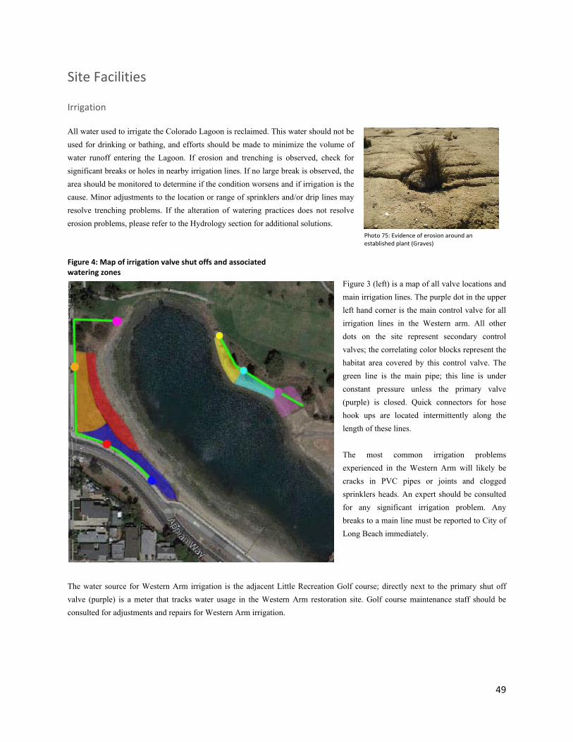
49
Site Facilities Irrigation All water used to irrigate the Colorado Lagoon is reclaimed. This water should not be used for drinking or bathing, and efforts should be made to minimize the volume of water runoff entering the Lagoon. If erosion and trenching is observed, check for significant breaks or holes in nearby irrigation lines. If no large break is observed, the area should be monitored to determine if the condition worsens and if irrigation is the cause. Minor adjustments to the location or range of sprinklers and/or drip lines may resolve trenching problems. If the alteration of watering practices does not resolve erosion problems, please refer to the Hydrology section for additional solutions.
Figure 3 (left) is a map of all valve locations and main irrigation lines. The purple dot in the upper left hand corner is the main control valve for all irrigation lines in the Western arm. All other dots on the site represent secondary control valves; the correlating color blocks represent the habitat area covered by this control valve. The green line is the main pipe; this line is under constant pressure unless the primary valve (purple) is closed. Quick connectors for hose hook ups are located intermittently along the length of these lines. The most common irrigation problems experienced in the Western Arm will likely be cracks in PVC pipes or joints and clogged sprinklers heads. An expert should be consulted for any significant irrigation problem. Any breaks to a main line must be reported to City of Long Beach immediately.
The water source for Western Arm irrigation is the adjacent Little Recreation Golf course; directly next to the primary shut off valve (purple) is a meter that tracks water usage in the Western Arm restoration site. Golf course maintenance staff should be consulted for adjustments and repairs for Western Arm irrigation.
Figure 4: Map of irrigation valve shut offs and associated watering zones
Photo 75: Evidence of erosion around an established plant (Graves)
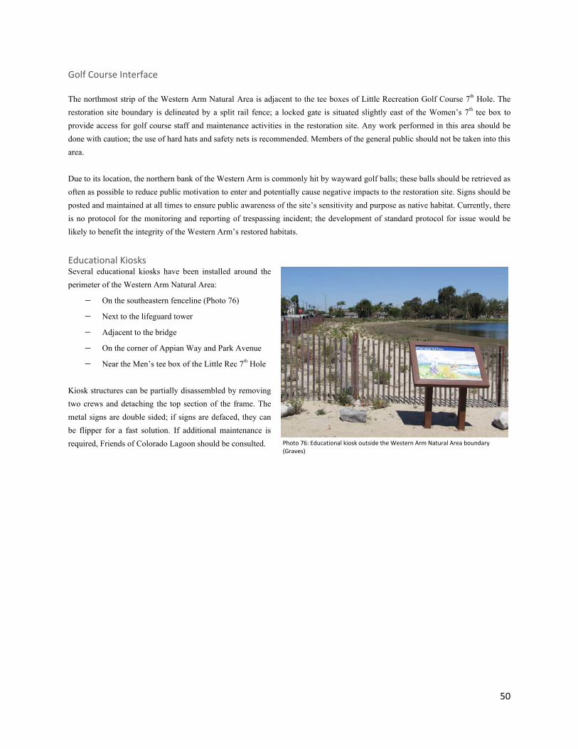
50
Golf Course Interface The northmost strip of the Western Arm Natural Area is adjacent to the tee boxes of Little Recreation Golf Course 7th Hole. The restoration site boundary is delineated by a split rail fence; a locked gate is situated slightly east of the Women’s 7th tee box to provide access for golf course staff and maintenance activities in the restoration site. Any work performed in this area should be done with caution; the use of hard hats and safety nets is recommended. Members of the general public should not be taken into this area. Due to its location, the northern bank of the Western Arm is commonly hit by wayward golf balls; these balls should be retrieved as often as possible to reduce public motivation to enter and potentially cause negative impacts to the restoration site. Signs should be posted and maintained at all times to ensure public awareness of the site’s sensitivity and purpose as native habitat. Currently, there is no protocol for the monitoring and reporting of trespassing incident; the development of standard protocol for issue would be likely to benefit the integrity of the Western Arm’s restored habitats.
Educational Kiosks Several educational kiosks have been installed around the perimeter of the Western Arm Natural Area:
− On the southeastern fenceline (Photo 76)
− Next to the lifeguard tower
− Adjacent to the bridge
− On the corner of Appian Way and Park Avenue
− Near the Men’s tee box of the Little Rec 7th Hole Kiosk structures can be partially disassembled by removing two crews and detaching the top section of the frame. The metal signs are double sided; if signs are defaced, they can be flipper for a fast solution. If additional maintenance is required, Friends of Colorado Lagoon should be consulted.
Photo 76: Educational kiosk outside the Western Arm Natural Area boundary (Graves)

51
Trails, Fences, & Gates Trails within the Western Arm Natural Area were created as maintenance trails, providing access for habitat improvements, irrigation adjustments and fixes, and other land management tasks. All maintenance trails are mulched with wood chips and highlighted with fiber rolls, branches, rocks, and other visually unobtrusive elements. To assure safe and reliable access to all areas of the Western Arm, trails should be regularly maintained by removing non-native weeds, trimming overgrown native plants, and replacing mulch and trail borders as needed. When trimming plants or maintaining borders, care should be taken to create winding, soft edges; maintenance trails should be no wider than 3 feet. Trails are not intended for public use, except during Habitat Restoration events hosted by Friends of Colorado Lagoon and other authorized partners. Around certain perimeter areas of the Western Arm, there are concrete sidewalks that are intended for public use. These path require maintenance to achieve safe accessibility; they should be regularly cleared of sand and plants should be trimmed so that they do not impact the trails in any way. Four gates are installed in the fenceline surrounding the Western Arm Natural Area to provide easy access to all restoration areas. Gate locations are depicted by yellow dots on the figure below. All gates are accessible using a City of Long Beach 6-key.
Figure 5: Map of Access Points to the Western Arm

52
Hydrology When this site was transformed into an aquatic recreation facility, the ability to maintain a deep and accessible water body was the main objective. Therefore, the tides were controlled and muted and shorelines were contoured with steep slopes. Beaches were built in the more gradually sloped areas to accommodate safe access for swimmers. As part of Colorado Lagoon’s dredging effort in 2012, the shoreline slopes in the Western Arm were re-contoured so as to maximize area for intertidal salt marsh and mudflat habitats. This elevation alteration, complimented by the 2010 culvert cleaning, created a new hydrological system within the lagoon. The dredging project removed nearly all the vegetation topsoil from the intertidal and supratidal areas of the Western Arm. In some instances, old marsh soils were exposed, while in other locations debris such as bricks and concrete (which were likely used to stabilize the banks) were exposed. A mosaic of soil types were found ranging from coarse grained beach sand and hard packed clay to marshy organic silts and loamy former turf areas. Along with the varying soil types, a variety of slopes resulted from the re-contouring efforts. Sheer slopes are found along the golf course edge. Long, gradual slopes exist between the 7th Tee Box and the Appian Way parking lot; these slopes become steeper in the southern areas of this stretch (near Appian Way). Erosion Erosion control bundles (aka fiber rolls) were installed above the transition zones upper edge for the entirety of the site that was scrapped by the re-contouring. This best management practice helped to not only trap upland soils headed downslope, but also acts as an excellent boundary line between the upland and transition zones. After one to two years, these 25 foot long wattles will bio-degrade and, since the soil they capture contains seeds, the bundles may become hot spots for germination. Even with the erosion control bundles, three locations in the western arm should be regularly monitored for potential erosion issues. The coastal dunes along the Appian Way parking lot have a relatively steep slope due to the close proximity of the sidewalk to the tideline. Furthermore, this area was formerly a sandy beach and a hard packed coarse grained soil type resulted from the re-contouring. When unsaturated, this hydrophobic soil type sheets water, which results in minor rutting. Small ruts may be beneficial to plant establishment, however large ruts should be avoided to protect the fenceline. Smaller 2-5 foot erosion control bundle sections supporting loose sandy backfill containing native seeds (preferably Camissonia cheiranthifolia) should be used to fill any large ruts. Dripline irrigation is most effective in saturating the soils in this area, while over head irrigation promotes erosion. The Lagoon is the low point for the surrounding neighborhoods; during high intensity rain events Park Avenue will flood and spill over the curb directly into the lagoon just south of the golf course’s 7th tee. This leads to upwards of 1 foot deep ruts being formed. However, this shoreline complexity is a positive development for the salt marsh habitat. Therefore, these ruts should not be filled. Since these large rain events are rare, eventually the vegetation will fully cover the soil and the rutting will be reduced naturally. Additionally, filling of wetland areas at the Lagoon must adhere to the conditions of a Coastal Development Permit.
Photo 77: Erosion blow out in the salt marsh on the western point (Graves)

53
The steepest slopes in the western are found between the golf course and the waterline. The slopes buffering Drain 452 (adjacent to the golf course) were not re-contoured; therefore the original intertidal vegetation persists and erosion is not a concern despite sheer slopes. Re-contouring east of this area resulted in steep unvegetated slopes that were planted immediately after being exposed and then again 1 year after. The vegetation will eventually fully cover this area; however, any persisting bare spots should be monitored and re-planted as deemed necessary. Overhead irrigation may generate erosion in this area and should be avoided. Historically, sand was introduced from Long Beach’s beachfront to portions of the lagoon that were used by swimmers and beach goers. The western arm restoration area includes a portion of these constructed beaches that has been transformed into a coastal dune plant community. A sandy substrate is preferred by the plant species that live here and small amounts of sand may be brought in by hand, however, large amounts of sand replenishment should be avoided here and throughout the Lagoon since it often erodes down slope and covers fine grained marsh soils and mudflats.
Sea Level Rise If realized, current predictions of 2-5 feet of sea level rise over the next 100-150 years would noticeably change the Colorado Lagoon’s landscape. Within the Western Arm Natural Area, the golf course and the Appian Way parking lot could both get flooded during high tides. In other areas the intertidal zone will move further upslope reducing the buffer between the marine habitats and urban edges. This shifting in sea level will require the marine communities to migrate upwards in elevation in order to survive. To accommodate this migration, a wide transition zone was established wherever conditions permitted. To best prepare for sea level rise, storm surge events coupled with spring tides should be used to estimate potential future tidal ranges. A variety of methods are used to protect resources from sea level rise worldwide including shoreline armoring and managed coastal retreat. The most appropriate method(s) for the Lagoon should be determined on a case-by-case scenario and composed in a Sea Level Adaptation Plan. Whenever possible the conservation of natural areas should be considered.
54
Tables & Figures Index Figure 1: Map of Colorado Lagoon, highlighting Western Arm………………………………………………………… 9 Figure 2: Close-Up of Western Arm Natural Area……………………………………………………………………………. 9 Table 1: Native Plant Species……………………………………………………………………………………………………………. 15 Table 2: Special Status Plant Species……………………………………………………………………………………………….. 18 Table 3: Non-native Plant Species…………………………………………………………………………………………………….. 22 Table 4: Algal Species……………………………………………………………………………………………………………………….. 25 Table 5: Terrestrial Fauna…………………………………………………………………………………………………………………. 29 Table 6: Marine Fauna……………………………………………………………………………………………………………………… 33 Table 7: Environmentally Sensitive & Special Status Fauna………………………………………………………......... 36 Figure 3: Designated Transects for Vegetation Monitoring……………………………………………………………… 41 Table 8: Avian Behavioral Actions……………………………………………………………………………………………………. 43 Table 9: Avian Habitat Usage……………………………………………………………………………………………………………. 43 Figure 4: Irrigation Map……………………………………………………………………………………………………………………. 49 Figure 5: Map of Western Arm Access Points………………………………………………………………………………….. 51