Embed Size (px)
Citation preview
American Spatial Development l Conservation Easements l Community Land Trusts l Social Urbanizer
Land LinesNewsletter of the Lincoln In sti tute of Land Policy
APRIL 2005
l LAND LINES l l 1
EDITORAnn LeRoyer
PRESIDENT & CEOH. James Brown
CHAIRMAN OF THE BOARDKathryn J. Lincoln
L a n d L i n e sAPRIL 2005 • VOL. 17, NO. 2
Features 1 American Spatial Development
and the New Megalopolis
5 Reinventing Conservation Easements
8 Community Land Trusts: Leasing Land for Affordable Housing
11 The Social Urbanizer: Porto Alegre’s Land Policy Experiment
Departments15 Faculty Profi le: Lawrence Susskind
17 New Lincoln Institute Book: Emerging Land and Housing Markets in China
18 New Copublished Books: Partnerships for Smart Growth and The Univerity as Urban and The Univerity as Urban andDeveloper
19 Program Calendar
The Lincoln Institute of Land Policy is a nonprofi t ed u ca -tion al institution established in 1974 to study and teach land policy and taxation. By sup port ing multidisciplinary educational, research and publications pro grams, the In- sti tute brings together diverse viewpoints to expand the body of useful knowledge in three de part ments—valuation and tax a tion, planning and de vel op ment, and interna-tional studies. Our goal is to make that knowledge com- pre hen si ble and accessible to citizens, policy makers and scholars in the United States and through out the world. The Lincoln Institute is an equal op por tu ni ty in sti tu tion in em ploy ment and ad mis sions.
Land Lines is published quarterly in January, April, July and October to report on Lincoln Institute-sponsored educational programs, publications and special projects.
Copyright ©2005Lincoln Institute of Land Policy113 Brattle Street, Cam bridge, MA 02138-3400 / USA
Tel: 617-661-3016 Fax: 617-661-7235
E-mail: [email protected] (editorial content) [email protected] (information ser vic es)
Web: www.lincolninst.edu
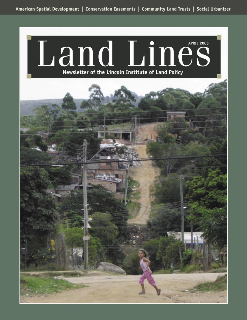
Cover: An informal settlement in Porto Alegre, Brazil. © Marcello Hameister
ASSISTANT EDITOREmily McKeigue
DESIGN & PRODUCTIONDavid Gerratt & Amanda Waitwww.Nonprofi tDesign.com
Gregory K. Ingram, Director-General, Operations Evaluation at the World Bank Group in Washington, DC, has been appointed by the Lincoln Institute
Board of Directors to succeed Jim Brown as president and chief executive offi cer, effective June 1, 2005. “I am very excited about joining the Lincoln Insti-tute at an important time in its history. I am impressed by its traditional focus on land and tax policy and its strong programs in the valuation and taxation, plan-ning and development, and international studies departments,” Ingram said. “This opportunity to lead the Institute allows me to draw upon my own interests and expertise in both the substantive areas of urban land markets, infrastructure and property taxation, and the management areas of program evaluation, policy development and research administration.” Since joining the World Bank in 1977, Ingram has held positions in research, urban development, infrastructure, evaluation, and manage-ment, including an early urban research project in Bogotá, Colombia, and more recent research in China. He currently is responsible for eval-uating operations, policies and programs at the Bank, the International Development Association, the International Finance Corporation and the Multilateral Investment Guarantee Agency. Ingram also has served on committees of the U.S. National Academy of Sciences and was formerly associated with the National Bureau of Economic Research. During the 1970s he was a graduate student and faculty member in the Department of Economics at Harvard Univer-sity, where he taught courses in urban economics, transportation eco-nomics and microeconomic simulation models. His involvement with the Lincoln Institute also spans several decades, including participation in the Institute’s World Congress on Land Policy and its Taxation Resources and Economic Development (TRED) conferences. He has conducted research in the areas of housing and land markets, urban economics, transportation, evaluation, and economic development. Among his many publications are World Development Report 1994: Infra-structure for Development and structure for Development and structure for Development Evaluation and Development: The Partnership Dimension; World Bank Policy Research Working Papers; articles in Urban Studies and Journal of Urban Economics; and chapters in the books Essays in Transportation Economics and Policy and Personal Cars and China. Ingram holds a Ph.D. in Economics from Harvard University, a B.A. and M.A. in Philosophy, Politics and Economics from Oxford University, and a B.S. in Civil Engineering from Swarthmore College. He and his wife Lee, an educational psychologist, have three adult children. “We look forward to returning to Cambridge and renewing our involvement with the lively academic community there,” Ingram noted. Kathryn Lincoln, chairman of the Lincoln Institute Board stated, “Greg brings the perfect blend of academic rigor and public policy ex-perience to Lincoln as its next president. His evaluation work at the World Bank will be especially valuable as we continue to develop our own monitoring methods for both program and process. Personally, I look forward to working with him and to this new era for the Institute.”
Greg Ingram
From the EDITOR
PRINTED ON RECYCLED PAPER USING SOY-BASED INKS
EARMANDO CARBONELL and ROBERT D. YARO
uropean efforts to develop policies and investments for the entire con-tinent and for regions that cross national boundaries have been
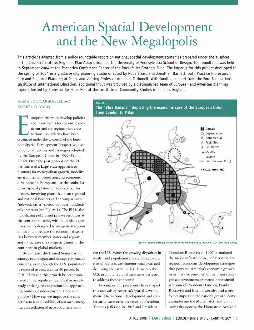
organized under the umbrella of the Euro-pean Spatial Development Perspective, a set of policy directives and strategies adopted by the European Union in 1999 (Faludi 2002). Over the past generation the EU has initiated a large-scale approach to planning for metropolitan growth, mobility, environmental protection and economic development. Europeans use the umbrella term “spatial planning” to describe this process, involving plans that span regional and national borders and encompass new “network cities” spread out over hundreds of kilometers (see Figure 1). The EU is also mobilizing public and private resources at the continental scale, with bold plans and investments designed to integrate the econ-omies of and reduce the economic dispari-ties between member states and regions, and to increase the competitiveness of the continent in global markets. By contrast, the United States has no strategy to anticipate and manage comparable concerns, even though the U.S. population is expected to grow another 40 percent by 2050. How can this growth be accommo-dated in metropolitan regions that are al-ready choking on congestion and approach-ing build-out under current trends and policies? How can we improve the com-petitiveness and livability of our own emerg-ing constellation of network cities? How
American Spatial Development and the New Megalopolis
can the U.S. reduce the growing disparities in wealth and population among fast-growing coastal regions, vast interior rural areas and declining industrial cities? How can the U.S. promote regional strategies designed to address these concerns? Two important precedents have shaped this analysis of America’s spatial develop-ment. The national development and con-servation strategies prepared by President Thomas Jefferson in 1807 and President
Theodore Roosevelt in 1907 stimulated the major infrastructure, conservation and regional economic development strategies that powered America’s economic growth in its fi rst two centuries. Other major strate-gies and investments promoted in the admini-strations of Presidents Lincoln, Franklin Roosevelt and Eisenhower also had a pro-found impact on the nation’s growth. Some examples are the Morrill Act land grant university system, the Homestead Act, and
This article is adapted from a policy roundtable report on national spatial development strategies prepared under the auspices of the Lincoln Institute, Regional Plan Association and the University of Pennsylvania School of Design. The roundtable was held in September 2004 at the Pocantico Conference Center of the Rockefeller Brothers Fund. The impetus for this project developed in the spring of 2004 in a graduate city planning studio directed by Robert Yaro and Jonathan Barnett, both Practice Professors in City and Regional Planning at Penn, and Visiting Professor Armando Carbonell. With funding support from the Ford Foundation’s Institute of International Education, additional input was provided by a distinguished team of European and American planning experts hosted by Professor Sir Peter Hall at the Institute of Community Studies in London, England.
FIGURE 1
The “Blue Banana,” depicting the economic core of the European Union from London to Milan
DorsaleDépendancesNord du SudAssimilésFinisterres
«Suds»LucuneLiaisons avec l'Est?Liaisons avec l'Est?
© RECLUS, Paris (1989)
Sources: Lincoln Institute of Land Policy and Regional Plan Association (2004) and Faludi (2002)
APRIL 2005 l LAND LINES l LINCOLN INSTITUTE OF LAND POLICY l 1
American Spatial Development CONTINUED
creation of the national rail and interstate highway systems.
Economic, Demographic and Spatial Trends Rapid population growth. The U.S. Census Bureau forecasts that the nation’s popula-tion will grow by 40 percent to 430 million by 2050, whereas most European countries are expected to lose signifi cant numbers of residents, due to declining birth rates and limited immigration. This means we must build half again as much housing and as much commercial and retail space and the infrastructure needed to support these activi-ties in the next half century as we have in the past two centuries. The study of historical settlement pat-terns sheds light on current and future pat-terns. While early settlers clung primarily to the coasts and in compact urban regions, the inventions of rail transportation and later the automobile forever changed settle-ment patterns and allowed people to set up homes in the interior of the country and in highly decentralized metropolitan areas. Fast-growing Sunbelt states, such as Texas, California and Florida, are expected to see sustained rapid population growth, spurred by the trend of immigrant popula-tions settling in those and surrounding states. While most central cities will continue to grow at a moderate pace, many metropol-itan regions around these urban cores are expected to experience remarkable develop-ment. As Philadelphia continues to lose population, for example, its adjacent suburbs and areas further outside the city continue to grow. In general, however, the number of people living in urbanized areas as op-posed to rural areas is projected to continue rising, signaling an increase in the amount of urbanized land in the coming decades.
The building out of suburban America.Since 1970 the vast majority of the nation’s economic and population growth has occurred in 30 large metropolitan regions, mostly in their sprawling outer rings. While some cities and inner-ring suburbs are now experienc-ing infi ll development and renewed popu-lation growth, many others are approaching “build-out,” which increases traffi c congestion
and commuting times, contributes to loss of farmland, and creates confl icts between new development and green infrastructure, such as public water supplies and wildlife habitat. In less than three centuries, 46 million acres of America’s virgin landscape have been converted to urban uses. In the next 25 years that number will more than double to 112 million acres. If current growth and land consumption rates continue, another 100 million acres will be urbanized by 2050, at a rate seven times faster than the popu-lation will grow. Uneven and inequitable growth patterns.While most population and economic growth has been in large metropolitan regions, other areas of the country have experienced losses. Large rural regions where resource-based economies or groundwater reserves are in permanent decline are left without the means to support even basic services. A number of large urban centers and second-tier cities also have experienced decades of decline. For example, Philadelphia, Baltimore, Pitts-burgh, Cleveland, Detroit, St. Louis and New Orleans have lost a third or more of their populations since 1960. Even in cities where the outer-ring suburbs have grown, many inner cities and inner-ring suburbs have lost residents, tax base and economic activity, and poverty has become highly con-centrated. Many of these places have high concentrations of African-Americans, Native Americans, Latinos and poor whites who will be increasingly disadvantaged as eco-nomic opportunities in these regions decline. In contrast with the U.S., the European Union for decades has invested vast sums to promote development and redevelopment of comparable bypassed areas. These in-vestments have produced dramatic results in revitalizing the economies of Ireland, Spain, Portugal and Greece, and formerly depressed cities and regions in Europe’s periphery. Similar strategic investments in disadvantaged American cities and regions could produce comparable results.
Limited infrastructure capacity. Metro-politan infrastructure of all kinds, most of it built in the last half of the twentieth century, will reach its capacity limits in the
fi rst decades of the twenty-fi rst century. Unless new capacity is created in roads, rails, airports, seaports and other systems, the nation’s economic potential will be artifi cially limited. Federal transportation investments over the past decade have been largely focused on maintaining the existing infrastructure, not on expanding the capacity of these systems. Over the last 50 years, Americans have become increasingly mobile. The increase in miles traveled per person has been most pronounced in car and aircraft travel, creating new challenges to keep various types of transportation corridors congestion-free. At the same time, congestion poses a serious threat to manufacturing and freight sectors of the economy. Experts believe that by 2020 there will be nearly a doubling of trucks on the roadways over current numbers. Signifi -cant policy measures are needed to channel more resources into high-capacity transpor-tation systems for both individual and commercial activity. Emergence of megalopolis. In 1961 French geographer Jean Gottman described the Boston–Washington Megalopolis. Between now and 2050, more than half of the nation’s population growth, and perhaps as much as two-thirds of its economic growth, will occur in this and seven other emerging megalopolitan regions whose extended networks of metropolitan centers are linked by interstate highway and rail corridors. Similar networks of cities in Europe and Asia are now seen as the new competitive units in the global economy. Major public and private investments are being made in high-speed rail, broadband communica-tions and other infrastructure to strengthen transportation and economic synergies among their component centers.
The New MegalopolisThe new megalopolis is a model for coopera-tion among the cities and regions in the U.S. that are growing together and creating dis-economies in congested transportation networks, which in turn affect the economic vitality and quality of life of these regions. This model is based on the idea that if the cities in these colliding regions work together
2 l LINCOLN INSTITUTE OF LAND POLICY l LAND LINES l APRIL 2005 l LAND LINES l l 3

they can create a new urban form that will increase economic opportunity and global competitiveness for each individual city and for the nation as a whole. These component metropolitan areas will have to cooperate in the formation of a structure that takes advantage of the com-plementary roles of each area while addressing common concerns in the areas of transporta-tion, economic development, environmental protection, and equity. The new megalopolis model will contribute to improving social and economic cohesion along with a better territorial balance, and will support more sustainable development by emphasizing collaboration on important policy issues, infrastructure investments and instruments for facilitating economic growth and job creation. To facilitate the development of megalo-politan areas, the U.S. could focus on creating a truly intermodal network linking rail, highway and air transportation. Such con-
nections would relieve congested airports and provide greater options for freight move-ment. The resulting transportation fl exi-bility would be less vulnerable to terrorist attacks and disaster. Furthermore, regional infrastructure and development focused around rail stations would shape and re-direct urban growth in more effi cient, less sprawling patterns. Our current direction is building a country whose competitiveness is threat-ened by ineffi cient urban forms and declining rural communities. The new megalopolis concept points us in a different direction, one in which urban areas and their surround-ing regions work together on a larger scale to address common concerns and share their complementary strengths. This new model would produce an America that is environ-mentally sustainable, socially equitable, and competitive in an increasingly global economy. Six distinctive regions can be identi-
fi ed based on common history, geographic location and topography: the Northeast, Mid-Atlantic, South, Midwest, Southwest and West. Most of the nation’s rapid popu-lation growth, and an even larger share of its economic expansion, is expected to occur in eight emerging metropolitan areas spread over thousands of square miles and located in every one of these regions (see Figure 2). These megalopolitan areas are becoming America’s economic engines: centers of technological and cultural inno-vation where the vast majority of immi-grants who are driving population and economic growth will assimilate into the economic and social mainstream. In Europe and Asia similar network cities are already being seen as the new competi-tive units in the global economy. The Euro-pean Union and national governments in Europe, China and Japan are investing hundreds of billions of dollars in new inter-modal transportation and communication
FIGURE 2
Emerging Megalopolitan Areas in the United States
Source: Lincoln Institute of Land Policy and Regional Plan Association (2004)
2 l l LAND LINES l APRIL 2005 l LAND LINES l LINCOLN INSTITUTE OF LAND POLICY l 3
American Spatial Development CONTINUED
� R E F E R E N C E S
Faludi, Andreas, ed. 2002. European spatial planning. Cambridge, MA: Lincoln Institute of Land Policy.
Lincoln Institute of Land Policy and Regional Plan Association. 2004. Toward an American spatial development perspective. Policy Roundtable Report. September.
University of Pennsylvania School of Design. 2004. Planning for America in a global economy: 2004–2005. City Planning Studio Report. Spring.
links and other infrastructure to underpin the capacity, effi ciency and livability of these regions. In all of these places, new high-speed rail networks are integrating the economies of formerly isolated regions. Toward an American Spatial Development PerspectiveAn American Spatial Development Per-spective (ASDP) could encompass long-range strategies to achieve fi ve broad national goals.1. Facilitate the emergence of eight new
megalopolitan areas that can compete with similar emerging networks of cities in Europe and Asia.
2. Create capacity for growth and improved global competitiveness in the nation’s transportation and other infrastructure systems.
3. Provide resiliency, redundancy and capacity in the nation’s infrastructure to respond to national security needs.
4. Revitalize bypassed urban and rural regions.
5. Protect and reclaim important nationally signifi cant natural resource systems and promote less land-consuming patterns of growth.
The federal government could play a crucial role in this process, through colla-borations with existing and emerging “bottom-up” networks of interconnected regional strategies, encompassing each of the emerging megalopoli. Ideally, the federal government would help coordinate and “incentivize” these planning efforts, but rely on local and regional initiatives to drive each region’s own strategies. The federal government could also lead in coordinating infrastructure planning and investments for national and regional inter-modal, high-speed transportation networks, as it did in promoting creation of the national rail and interstate highway systems. These investments would be made through part-nerships between federal, state and regional government, and private investors. User fees, tolls and fares would cover a substantial portion of the cost of developing and managing these systems. Regional strategies could also promote investments in major higher education and research institutions needed to maintain the
nation’s competitive advantage in technology and create a lifelong learning system to help skilled workers adapt to economic change. This broad approach could also identify the important natural resource systems that sustain public water supplies, biological resources, sense of place and recreational opportunities. Future growth could be designed to reuse formerly used sites and to reclaim and restore impaired landscapes and natural resource systems. Plans for these infrastructure systems should be closely coordinated with strategies for smaller-scale urban and regional develop-ment, to ensure that future development patterns support, and are supported by, these infrastructure investments. Federal and state governments could invest in demonstration projects to test innovative transportation, land use, environmental and other strategies.
Building and Financing the ASDPThe proposed new infrastructure systems and urban development outlined in this article could cost trillions of dollars, much of which could be fi nanced through user fees and public-private partnerships. It should also be possible to employ modest payroll or other taxes to fi nance some of these invest-ments, which would generate trillions of dollars of new economic capacity for the whole nation. The expected doubling of the national economy by 2050 would expand the gross domestic product by more than $14 trillion (in constant dollars). Redirect-ing even a small share of the growth of tax revenues in these strategic investments could secure the nation’s economic future. For over a hundred years, the U.S. has fi nanced major infrastructure projects through a “top-down” system, with major funding from the federal government complemented by state resources. Based on general public agreement of national priorities, this model fi nanced several gene-rations of growth and paid for one of the world’s great infrastructure systems. However, this approach is now being challenged as the needs of maintaining our aging infra-structure systems outpace federal and state funding, to say nothing of new capacity expansion. Today we witness a debate between “donor” and “donee” states over
the fairness of federal transportation funds, even as the total amount of federal dollars falls far short of estimated needs. As a re-sult, we fi nd ourselves increasingly starved for capital for infrastructure systems. To provide more funding for system maintenance and expansion, metropolitan regions are looking to new and innovative fi nancing systems. Public authorities use their tax-free status to attract private dollars through bond issuances, sales and lease-back arrangements. New user fees, such as con-gestion pricing or high-occupancy-vehicle lanes on toll roads, link charges to those who benefi t the most from new investments, creating new revenue streams. And value capture models, such as tax increment fi nancing, allow increases in land values to fi nance infrastructure investments. The federal government is advancing instruments such as TIFIA, the Transpor-tation Infrastructure Innovation Act, to stimulate the development of these projects. However, megalopolitan areas have a critical role to play in this emerging system. They provide a vital link between state and federal government and local jurisdictions, which in many cases have the last word over land use decisions. These regional areas transcend political boundaries and capture the true economic and social geography of their communities. And they have the size, capa-city and expertise to undertake complex planning strategies.
ARMANDO CARBONELL is senior fellow and co-chair of the Lincoln Institute’s Depart-ment of Planning and Development. Contact: [email protected]. ROBERT D.
YARO is president of the Regional Plan Association in New York City. Contact: [email protected].
4 l LINCOLN INSTITUTE OF LAND POLICY l LAND LINES l APRIL 2005 l LAND LINES l l 5
Reinventing Conservation Easements
N
4 l l LAND LINES l APRIL 2005 l LAND LINES l LINCOLN INSTITUTE OF LAND POLICY l 5
JEFF PIDOT
o recent happening in land conservation rivals the deploy-ment from coast to coast of conservation easements. Be-
yond tax and other public subsidies, one of the driving forces favoring this phenome-non is that conservation easements are perceived as a win-win strategy in land protection, by which willing landowners work with private land trusts or govern-ment agencies to provide lasting protec-tion for portions of the American land-scape. Conservation easements leave land in private ownership, while allowing the easement holder (the land trust or agency) to enforce voluntary, contracted-for, often donated but increasingly paid-for restric-tions on future uses of the easement-encumbered property. Conservation ease-ments are often welcomed as achieving the goals of land protection without regula-tion or adversity, and usually without any government oversight. At the same time, the rapid increase in the use of conservation easements raises the concern that they may present some-thing of a time bomb that requires pre-ventive action. Most of the laws and con-ventions concerning conservation easements were created at a time when no one could have foreseen their explosive growth and complexity. These laws and conventions require well-considered approaches to reform, lest we ultimately risk losing the public benefi ts that we thought conserva-tion easements would secure in the future.
The Public Stake in Conservation EasementsWhy should the public, and therefore its government at all levels, care about how conservation easements are created and managed? One reason is that virtually every conservation easement is associated with a signifi cant public subsidy. Although most easements are donated by private landowners to private land trusts, they
almost always result in public subsidies in the form of income tax deductions to the easement donors. In many cases a further subsidy comes in the form of reduced real property and estate taxes in the future. Increasingly, conservation easements are being purchased with public money, some-times on a grand scale involving millions of dollars. The public should care about how its money is being spent, whether it is being spent for something of long-term public benefi t, and whether it is being spent effi ciently; that is, the public should be interested in whether it is getting a fair public bang for its buck. Beyond the public’s fi nancial invest-ment, its interest in conservation easements as a form of charitable trust transcends the interests of the private parties to the trans-action. Further, some conservation ease-ments guarantee public access to the prop-erty, such as for hiking or scenic enjoyment, giving the public an added stake in the long-term security of the easement. In the case of conservation easements granted by developers as a quid pro quo for regula-tory permits, these easements may also comprise a public investment because they are part of the consideration in exchange for the right to proceed with a project that may cause environmental harm. Finally and not least importantly, the public has an abiding concern in the orderly future of legal understandings and the stability of interests in real estate. In sum, when a conservation easement is created there is a legitimate public in-terest and concern that the terms of the easement will be honored and that the easement holder will have the capacity and resolve to monitor, enforce and defend the restrictions of the easement in perpetuity, as conservation easements promise. Indeed, the very purpose of state and federal laws that support and subsidize the creation of conservation easements is that the public interest is intended to permanently benefi t from them.
Defi nitionsA conservation easement (in some states conservation easement (in some states conservation easementreferred to as a conservation restriction or similar term) is a set of permanently enforceable rights in real property, held by a private nonprofi t corporation (typi-cally a land trust) or a government agency. These rights impose a negative servitude (in other words, a set of promises notto do certain things) on the encumbered land, and they are permanently enforce-able by the easement holder. Conservation easements are a relatively recent inven-tion of real estate law and are enabled by statute in virtually every state.
A land trust is a loosely defi ned concept land trust is a loosely defi ned concept land trustthat usually includes at least two basic elements. First, it is a private, nonprofi t charitable corporation incorporated under the laws of a state and qualifi ed as tax-exempt and entitled to receive tax-deductible donations under section 501(c)(3) of the Internal Revenue Code. Second, depending on state law, a land trust’s mission, but not necessarily its exclusive or even primary one, is the conservation of land.
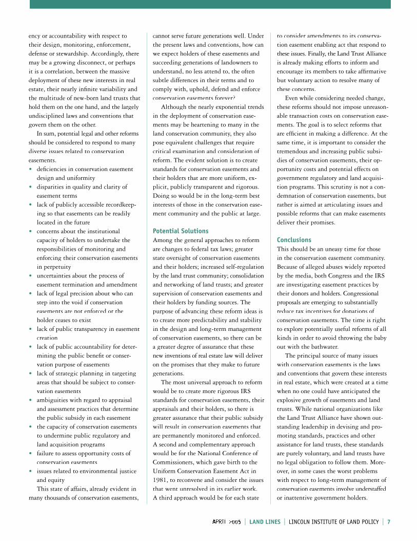
Trends and Problems Rapid growth. The attractiveness of conservation easements is demonstrated by the explosive growth of land trusts estab-lished to accept easements. Land trusts have become a big business in America, both for their vast holdings of conservation easements and other properties and for their increasing memberships and fi nances. Even so, many land trusts have come into existence only during the past 15 years and operate at a local level. While land trust creation continues to increase rapidly, an important policy question is whether the ever-expanding number of small land trusts throughout the nation is something that is good for our (and their) future. The Land Trust Alliance (LTA), an organization that serves many land trusts nationwide, reported in its national census
Reinventing Conservation Easements CONTINUED
6 l LINCOLN INSTITUTE OF LAND POLICYLINCOLN INSTITUTE OF LAND POLICY l LAND LINES l APRIL 2005 l LAND LINES l l 7
that between 1998 and 2003 the number of local and regional land trusts increased 26 percent from 1,213 to 1,526; the num-ber of conservation easements held by these land trusts grew from 7,400 to nearly 18,000; and the area covered by these ease-ments expanded from nearly 1.4 million acres to more than 5 million acres (Land Trust Alliance 2004; see Figures 1 and 2). In addition, there are a number of national organizations, such as The Nature Conser-vancy and the American Farmland Trust, that hold additional thousands of conser-vation easements. Untold thousands of easements also are held by federal, state and local governments. Often land trusts and government agen-cies alike focus on, publicize and celebrate the accumulating numbers of conservation easements in their portfolios, as well as the numbers of acres that they cover, without equivalent regard for the quality of the easements or of the lands they protect. Since conservation easements bring with them long-term and costly responsibilities for the holder in monitoring, stewardship, enforcement and defense, this focus on numbers can be short-term thinking that leads to long-term problems.
Lack of uniformity. The terms of conser-vation easements are infi nitely variable. Calling something a conservation easement tells one nothing about what protections it affords or even what legal boilerplate
it includes. Many conservation easement advocates extol the virtues of this fl exibil-ity, since it allows the landowner and ease-ment holder to tailor each easement to their mutual interests. However, this increasing variability of conservation easements inevitably will result in more problems over time for both easement holders and future successions of landowners in understanding, undertaking, monitoring, defending and upholding all of the legal rights and responsibilities of each easement. Heightening this effect is the fact that many conservation easements are increasingly negotiated, nuanced and complex agreements, leaving even legal experts challenged in easement prepara-tion, interpretation, oversight and enforcement.
Valuation issues. The valuation problem for conservation easements arises in two forms: the opportunity for excessive claims of income, estate and property tax deduc-tions or reductions; and uncertainty as to the societal and cost-benefi t calculus of each easement. The valuation of donated
3.5
3.0
2.5
2.0
1.5
1.0
0.5
0
Acre
s Co
nser
ved
(mill
ions
)
600
500
400
300
200
100
0
Num
ber
of L
and
Trus
ts
Northeast
Pacific
Mid-Atlantic
Southwest
Northwest
Southeast
Midwest
FIGURE 2
Acres Conserved and Number of Land Trusts by Region, 2003
Source: Adapted from Land Trust Alliance, National Land Trust Census (http://www.lta.org/census/index.shtml)
1950 1960 1970 1980 1990 2000Year
1600
1400
1200
1000
800
600
400
200
0
Num
ber
of L
and
Trus
ts
1950 1965
1975
19811985
1988
1990
1994
19982000
2003
FIGURE 1
Growth in the Number of Land Trusts, 1950–2003
Source: Adapted from Land Trust Alliance, National Land Trust Census (http://www.lta.org/census/index.shtml)
conservation easements has become a major cause for alarm by the Internal Revenue Service, which says that it will be apply-ing an increasingly watchful eye on the deductions taken for these donations. How-ever, part of the problem may be that the IRS has not been precise enough in stating how conservation easement appraisals should be undertaken. Even if the IRS adopts a more rigorous approach to easement appraisal in the future, it will never be in a good position to de-termine whether each easement, for which a charitable deduction is taken, is worthy in terms of conferring a public benefi t commensurate with the public subsidy. That task must be undertaken by others, starting with the land trust or other ease-ment holder and embracing some degree of broader public participation.
Lack of legal standards. While conser-vation easements are intended to be perma-nent servitudes on privately held property, most states have no public registry for conservation easements, no particular legal structure and no public review, transpar-
6 l l LAND LINES l APRIL 2005 l LAND LINES l LINCOLN INSTITUTE OF LAND POLICY l 7
ency or accountability with respect to their design, monitoring, enforcement, defense or stewardship. Accordingly, there may be a growing disconnect, or perhaps it is a correlation, between the massive deployment of these new interests in real estate, their nearly infi nite variability and the multitude of new-born land trusts that hold them on the one hand, and the largely undisciplined laws and conventions that govern them on the other. In sum, potential legal and other reforms should be considered to respond to many diverse issues related to conservation easements. • defi ciencies in conservation easement
design and uniformity• disparities in quality and clarity of
easement terms• lack of publicly accessible recordkeep-
ing so that easements can be readily located in the future
• concerns about the institutional capacity of holders to undertake the responsibilities of monitoring and enforcing their conservation easements in perpetuity
• uncertainties about the process of easement termination and amendment
• lack of legal precision about who can step into the void if conservation easements are not enforced or the holder ceases to exist
• lack of public transparency in easement creation
• lack of public accountability for deter-mining the public benefi t or conser-vation purpose of easements
• lack of strategic planning in targeting areas that should be subject to conser-vation easements
• ambiguities with regard to appraisal and assessment practices that determine the public subsidy in each easement
• the capacity of conservation easements to undermine public regulatory and land acquisition programs
• failure to assess opportunity costs of conservation easements
• issues related to environmental justice and equity
This state of affairs, already evident in many thousands of conservation easements,
cannot serve future generations well. Under the present laws and conventions, how can we expect holders of these easements and succeeding generations of landowners to understand, no less attend to, the often subtle differences in their terms and to comply with, uphold, defend and enforce conservation easements forever? Although the nearly exponential trends in the deployment of conservation ease-ments may be heartening to many in the land conservation community, they also pose equivalent challenges that require critical examination and consideration of reform. The evident solution is to create standards for conservation easements and their holders that are more uniform, ex-plicit, publicly transparent and rigorous. Doing so would be in the long-term best interests of those in the conservation ease-ment community and the public at large.
Potential SolutionsAmong the general approaches to reform are changes to federal tax laws; greater state oversight of conservation easements and their holders; increased self-regulation by the land trust community; consolidation and networking of land trusts; and greater supervision of conservation easements and their holders by funding sources. The purpose of advancing these reform ideas is to create more predictability and stability in the design and long-term management of conservation easements, so there can be a greater degree of assurance that these new inventions of real estate law will deliver on the promises that they make to future generations. The most universal approach to reform would be to create more rigorous IRS standards for conservation easements, their appraisals and their holders, so there is greater assurance that their public subsidy will result in conservation easements that are permanently monitored and enforced. A second and complementary approach would be for the National Conference of Commissioners, which gave birth to the Uniform Conservation Easement Act in 1981, to reconvene and consider the issues that went unresolved in its earlier work. A third approach would be for each state
to consider amendments to its conserva-tion easement enabling act that respond to these issues. Finally, the Land Trust Alliance is already making efforts to inform and encourage its members to take affi rmative but voluntary action to resolve many of these concerns. Even while considering needed change, these reforms should not impose unreason-able transaction costs on conservation ease-ments. The goal is to select reforms that are effi cient in making a difference. At the same time, it is important to consider the tremendous and increasing public subsi-dies of conservation easements, their op-portunity costs and potential effects on government regulatory and land acquisi-tion programs. This scrutiny is not a con-demnation of conservation easements, but rather is aimed at articulating issues and possible reforms that can make easements deliver their promises.
ConclusionsThis should be an uneasy time for those in the conservation easement community. Because of alleged abuses widely reported by the media, both Congress and the IRS are investigating easement practices by their donors and holders. Congressional proposals are emerging to substantially reduce tax incentives for donations of conservation easements. The time is right to explore potentially useful reforms of all kinds in order to avoid throwing the baby out with the bathwater. The principal source of many issues with conservation easements is the laws and conventions that govern these interests in real estate, which were created at a time when no one could have anticipated the explosive growth of easements and land trusts. While national organizations like the Land Trust Alliance have shown out-standing leadership in devising and pro-moting standards, practices and other assistance for land trusts, these standards are purely voluntary, and land trusts have no legal obligation to follow them. More-over, in some cases the worst problems with respect to long-term management of conservation easements involve understaffed or inattentive government holders.
Reinventing Conservation Easements CONTINUED
acquisition, should be legally account-able for upholding their part of the bar-gain, including monitoring and uphold-ing the terms of each easement and assuring that its public benefi ts are secured in the future.
3. The process by which conservation easements are designed, appraised and managed should be more rigorous, publicly transparent and accountable.
With these principles in mind, there are many approaches to resolving the issues presented by conservation easements. However, to fashion the solutions one must fi rst acknowledge the problems. If ever we are to take action to assure the future of conservation easements, the time to do so may never be better, nor easier, than now.
JEFF PIDOT is a visiting fellow at the Lincoln Institute, on leave from his work as chief of the Natural Resources Division of the Maine Attorney General’s Office, a position
he has held since 1990. He has been an active participant in the land trust movement in Maine and has a wealth of experience with conservation easements in both his professional and volunteer work. While at the Lincoln Institute, he is researching and writing about the challenges of conservation easements and reforms that may be considered to meet these challenges. His working paper, Reinventing Con-servation Easements: A Critical Examina-tion and Ideas for Reform, is available on the Institute’s Web site at www.lincolninst. edu/pubs/workingpapers/. In the summer of 2005 the Institute will publish a policy focus report on this topic. For further information or to provide comment, contact: jpidot@ lincolninst.edu.
� R E F E R E N C E
Land Trust Alliance. 2004. National Land Trust Census. November 18. http://www.lta.org/census/index.shtml
ROSALIND GREENSTEIN and YESIM SUNGU-ERYILMAZ
For many households experiencing lagging wages or underemploy-ment, the purchase and fi nancing of a house is increasingly diffi -
cult. High land costs are another obstacle to developing and securing affordable hous-ing for lower-income families in some mar-kets. One way to address this second issue is to purchase a house without the land, and a community land trust (CLT) is one mechanism that allows this arrangement. This article reports on a roundtable attended by approximately 25 researchers, policy analysts, technical assistance providers, funders and CLT staff members to discuss the CLT model and related research needs. The December 2004 program was spon-
sored by the Lincoln Institute in partner-ship with the Institute for Community Economics (ICE), based in Springfi eld, Massachusetts.
What are CLTs and How Do They Function? The CLT model has evolved in the United States over the last 40 years (ICE 1991). Currently there are approximately 160 CLTs operating in every region of the country and in 38 out of the 50 states and the Dis-trict of Columbia. These CLTs are nonprofi t, community-based organizations whose mission is to provide affordable housing in perpetuity by owning land and leasing it to those who live in houses built on that land. Complementing their status as non-profi t corporations, as defi ned in the U.S. tax code, and their formal rights and respon-
sibilities codifi ed in the ground lease, CLTs are governed by a board of directors with membership from the community. In the classic CLT model, membership is com-prised of adults who live in the leased hous-ing (leaseholders); adults who live in the targeted area (community members); and local representatives from government, fund-ing agencies and the nonprofi t sector (pub-lic interest) (Burlington Associates 2003). The CLT and the homeowner agree to a long-term ground lease agreement (typi-cally 99 years) that spells out the rights and responsibilities of both parties. Among the homeowner’s rights are the rights to privacy, the exclusive use of the property, and the right to bequeath the property and the lease. The CLT has the right to purchase the house when and if the owner wants to sell.
Community Land Trusts:Leasing Land for Affordable Housing
8 l LINCOLN INSTITUTE OF LAND POLICY l LAND LINES l APRIL 2005 l LAND LINES l l 9
How dire is the future of conservation easements? Just as conservation easements are intended to endure, each of the prob-lems reported here will have its day, and some already have. When evaluating the effectiveness of conservation easements under the prevailing legal structure, per-haps the best answer is that the jury will be out for 100 years, but one should be suffi ciently concerned about a possibly adverse verdict to consider these issues and ways to resolve them. If conservation easements are to serve future generations as is their promise, they will have to live up to three essential principles. 1. The value of conservation easements
depends upon their being able to effec-tively and permanently deliver the public benefi ts they promise.
2. Landowners and conservation easement holders, who receive the benefi ts of the state and federal laws that provide for and subsidize conservation easement
The CLT’s abiding interest, as the land-owner, as the party with the option to pur-chase the improvement, and as a commu-nity-based organization, is to maintain a stake in the relationship long after the original house purchase and lease signing. For example, if buildings become deteri-orated, the CLT can force repairs; if the homeowners are at risk for default the CLT can and does act to forestall the default. The ground lease also includes a resale formula intended to balance the interests of present homeowners with the long-term goals of the CLT. The intent of affordabil-ity in perpetuity is in confl ict with the desire of most owner-occupants in the U.S. to reap real estate gains. Thus, the resale formula is designed to balance the interest of individual homeowners to benefi t from the use of their home as a real estate invest-ment and the interest of the CLT to provide affordable housing for future homeowners.
Research AgendaThe CLT model is an extremely attractive mechanism for maintaining and expand-ing the stock of affordable housing. While the stories one hears from and about CLTs are encouraging and inspiring, little research exists regarding their effectiveness. Fur-thermore, despite their many attractive attributes, CLTs are neither well known nor extensively used in the U.S. During roundtable discussions, the participants exchanged perspectives and identifi ed six clusters of questions that would constitute a short-term CLT research agenda to help inform future action.
Do CLTs provide long-term affordable housing?The separation of ownership of land and buildings is the mechanism by which long-term affordability is achieved. Much of the value in structures comes from their functionality, the materials used and the level of maintenance. These are the con-tributions of the builder and owner. Much of the value in land comes from its loca-tion with respect to natural elements, urban services such as transportation and public schools, and disamenities such as solid waste dumps or prisons. Many of the fac-
tors that contribute to land value increases are due to the economic expansion that occurs in metropolitan areas. In strong markets the pace of value increases in land exceeds that of structures. Thus, if the land is excluded from the price of housing, affordability ought to be assured over time. Research is needed to evaluate the effec-tiveness of the CLT tool in providing long-term housing affordability and to evaluate CLTs as compared to other affordable housing programs.
Do CLTs contribute to individual asset building?CLT housing provides residents with shelter, security of tenure, access to credit and access to urban services, among other benefi ts. However, individual real estate profi ts are limited by the design of the resale formula, which varies among CLTs. Outcomes also will vary with real estate cycles in particular cities and regions. A second question, then, has to do with the degree to which the limitation on real
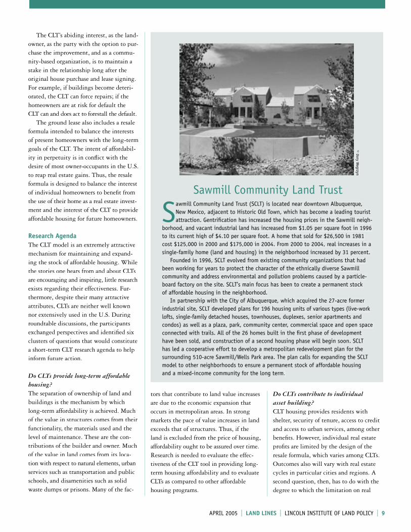
Sawmill Community Land Trust
Sawmill Community Land Trust (SCLT) is located near downtown Albuquerque, New Mexico, adjacent to Historic Old Town, which has become a leading tourist attraction. Gentrifi cation has increased the housing prices in the Sawmill neigh-
borhood, and vacant industrial land has increased from $1.05 per square foot in 1996 to its current high of $4.10 per square foot. A home that sold for $26,500 in 1981 cost $125,000 in 2000 and $175,000 in 2004. From 2000 to 2004, real increases in a single-family home (land and housing) in the neighborhood increased by 31 percent. Founded in 1996, SCLT evolved from existing community organizations that had been working for years to protect the character of the ethnically diverse Sawmill community and address environmental and pollution problems caused by a particle-board factory on the site. SCLT’s main focus has been to create a permanent stock of affordable housing in the neighborhood. In partnership with the City of Albuquerque, which acquired the 27-acre former industrial site, SCLT developed plans for 196 housing units of various types (live-work lofts, single-family detached houses, townhouses, duplexes, senior apartments and condos) as well as a plaza, park, community center, commercial space and open space connected with trails. All of the 26 homes built in the fi rst phase of development have been sold, and construction of a second housing phase will begin soon. SCLT has led a cooperative effort to develop a metropolitan redevelopment plan for the surrounding 510-acre Sawmill/Wells Park area. The plan calls for expanding the SCLT model to other neighborhoods to ensure a permanent stock of affordable housing and a mixed-income community for the long term.
© Dory Wegrzyn
8 l l LAND LINES l APRIL 2005 l LAND LINES l LINCOLN INSTITUTE OF LAND POLICY l 9
estate profi ts limits individual asset build-ing. It is possible, for example, that the security of tenure and the predictability in housing costs provided by the CLT allow individuals to pursue other, non-real estate strategies for asset accumulation.
How effective are public and nonprofi t sector funds when used to produce CLT housing?In most cases, CLT housing requires subsidies for the purchase of land and/or house construction. Grants typically come from various government sources or private foundations. One of the premises of the CLT model is that these subsidies are recycled later to reclaim the value of the subsidies and to benefi t future home-buyers. Public subsidies are no longer needed when a CLT house is sold under the resale formula. However, it is not known how effi cient subsidies are when used to develop CLT housing and how the subsidy capture mechanisms work.
Do CLTs provide access to urban services and/or regional opportunities for leaseholders? Quality of housing in the U.S. is closely related to residential location. However, location infl uences more than simply house quality; it also affects the existence and quality of job opportunities and urban services such as access to transportation, health care, libraries and public schools, all of which have direct and indirect effects on quality of life and life chances. Researchers looking at regional policy solutions are particularly interested in whether and how CLTs infl uence this access to urban services. Economists use the term “spatial mismatch” to refer to the imbalance between the location of many employment opportunities in the suburbs and the loca-tion of unemployed jobseekers in the city centers. Many participants at the round-table were interested in exploring the degree to which CLTs facilitate bridging this mis-match because of their specifi c location within a region, their connections to other organizations in the neighborhood and region, or employment and training pro-grams offered to support CLT residents.
Do CLTs contribute to community building? CLTs are unique among U.S. community-based organizations in that their concerns are geographically focused and include economic relationships, the governance structure of the organization, and the provision of direct services. In some com-munities CLTs are connected to other or-ganizations serving the same community or the same constituency. Much of the literature on neighborhood development and revitalization focuses on the impor-tance of “social capital” to people and their community. Do CLTs contribute to this connective tissue of neighborhoods? How and why? Some CLTs operate across a num-ber of communities and thus have a more regional focus. This difference among CLTs will lead us to consider questions of scale and community defi nition.
Why have some CLTs excelled and others failed?There is great variation in CLTs across the country. The largest, Burlington Com-munity Land Trust in Vermont, has 370 single-family homes and condominiums and 270 rental apartment leases; other CLTs may have just a handful of units available for lease. Some CLTs have been able to grow signifi cantly while others have not, and some have ceased operation altogether. There are many possible reasons for this variation in success, including staff resources and skills; differences in mission; fi nanc-ing arrangements; ability to receive dona-tions of land; and the strength or weakness of the local land and housing market.
Future Activities Regarding CLTsThe Lincoln Institute is interested in CLTs because they provide a window that en-courages a deeper understanding of the signifi cant role that land plays in social and economic development and the mech-anisms by which it occurs. The roundtable participants hope that investigation into this research agenda would accomplish a number of objectives. First, new research would spread knowledge of CLTs to practitioners in fi elds ranging from urban development to
� R E F E R E N C E S
Burlington Associates in Community Development, LLC. 2003. Key features of the “classic” community land trust. Burlington, VT: Burlington Associates.
Institute for Community Economics (ICE) 1991. The community land trust legal manual. Springfi eld, MA: ICE.
� R E S O U R C E S
Burlington Community Land Trust (http://www.bclt.net/)
Fannie Mae Corporation (search for the link to CLTs) (http://www.fanniemae.com/housingcommdev/)
Institute for Community Economics (ICE) (http://www.iceclt.org)
Policy Link. See Equitable Development Toolkit and link to CLT case studies. (http://www.policylink. org/EDTK/CLT/action.html)
National Housing Institute (NHI) (http://www.nhi.org/)
Community Land Trusts CONTINUED
housing policy, neighborhood planning, community organizing, regional sustain-ability and equity. Second, among policy analysts this research will improve our understanding of the strengths and weak-nesses of the CLT model and the contexts in which it is most useful and successful. For CLT members, leaseholders, staff and board members, the fi ndings will provide an understanding of their locally based work within a national context. For fund-ers and lenders the investigations will provide an empirical base from which to make future funding decisions. This work will be conducted by the Lincoln Institute, the Institute for Com-munity Economics, representatives of organizations who attended the roundtable and others who become engaged in these issues. For example, the National Housing Institute already has begun a study of shared equity home ownership. We expect that documenting, investi-gating and analyzing the history of CLTs and individual experiences will provide a better understanding the role of land in housing affordability.
ROSALIND GREENSTEIN is senior fellow and co-chair of the Lincoln Institute’s Depart-ment of Planning and Development. Contact: [email protected]. YESIM SUNGU-
ERYILMAZ is a research assistant in the Lincoln Institute’s Department of Planning and Development. Contact: [email protected].
10 l LINCOLN INSTITUTE OF LAND POLICY l LAND LINES l APRIL 2005 l LAND LINES l l 11
MARTIM O. SMOLKA and CLÁUDIA P. DAMASIO
Approximately one billion people around the world currently live in slums with precarious infrastructure and
without basic services or secure land title, and this situation is expected to worsen in the future (UN-HABITAT 2003). From the perspectives of both the urban order and the environment, irregular land occu-pations often cause irreversible damage and impose high urbanization costs for the local government and the society as a whole. Irregularity is a multidimensional phe-nomenon involving tenure issues (e.g., legal rights of occupation, title registration); compliance with urban norms and regula-tions (e.g., lot sizes, allowance for public spaces, street layouts); the number and quality of services provided; the type of area where settlement occurs (e.g., ecologi-cally risky areas, hillsides, contaminated brownfi elds); and above all the occupation process itself, which is usually the oppo-site of formal development, whereby occu-pation is the culmination of a legal and regulated sequence from titling to plan-ning to servicing. Basic infrastructure is frequently avail-able in irregular areas, but it is installed either by unregulated subdividers or after occupation by public agencies, often as an emergency measure. For example, some-times the main trunk networks for water and sewer systems exist close to areas where irregular settlements are forming, so the subdivider or occupants simply improvise clandestine connections to tap into the main line. For small settlements this kind of intervention is not disastrous, yet it
tion pro-grams are being established in many cities, but their effectiveness to date has been limited (Smolka 2003). More seriously and paradoxically, the expecta-tion created by these programs has tended to increase the number of people resorting to irregularity. In sum, the typical process by which the urban poor access serviced land is ineffi cient and unfair, and ulti-mately feeds into a vicious cycle of irregu-larity by contributing to poverty rather than mitigating it. The problem is not so much what services are provided, by whom and at what scale, but how, when and where the process operates to provide those services in the fi rst place.
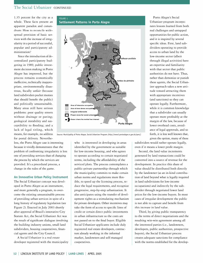
The Case of Porto AlegrePorto Alegre (population 1,360,590 in 2000) is the capital of the southernmost state in Brazil and the center of a metro-politan area of 31 municipalities (see Figure 1, page 12). The city’s quality of life improvements have gained worldwide recognition, largely as a result of its poverty reduction and social inclusion programs and its widely acclaimed participatory administration processes (Getúlio Vargas Foundation 2004; Jones Lang Lasalle 2003; UNDP 2003). For example, the level of infrastructure services is very high: 84 per-cent of the city’s houses are connected to the sewerage system; 99.5 percent receive treated water; 98 percent receive electric-ity; and 100 percent of suburbs are serviced by selective waste collection (Municipality of Porto Alegre 2003). In spite of these impressive fi gures, 25.5 percent of the population lives in the city’s 727 irregular settlements (Green 2004). It is estimated that the annual population growth in these areas is 4 percent compared to
The Social Urbanizer:Porto Alegre’s Land Policy Experiment
implies that services may be extended into areas that are unsuitable for occupation. Private or public utility companies also extend their services to new settlements irrespective of their legal status, and often without consulting the local authorities.
Typical Occupation Processes The most common current practice for creating irregular settlements involves the occupation of a parcel of land through a complex series of commercial transactions involving the landowner, the developer or land subdivider, and often the future occu-pants. Landowners seek a way to extract profi ts from the land; subdividers ignore the need to comply with municipal codes and produce a low-cost, high-profi t sub-division; and the poor occupants purchase these illegal plots because they have no other option and may be unaware of the legal status. They usually lack a regular income source and savings to apply for credit and meet the stringent building codes and other conditions required for formal purchase and occupation. Prospective occupants buy the “right to occupy” through a plot acquisition con-tract and proceed to organize plot boun-daries, street layouts and the construction of simple houses. When an offi cial inspec-tion is made it’s already too late; houses have been built and the community is or-ganized to resist. Public authorities cannot keep up with this cycle of complicity, and thus restrict their role to minimal inspec-tion activities that both conceal a manage-ment model tolerant of informality and expose the absence of other housing options for that segment of the population. High-cost curative actions to introduce urban improvements and title regulariza-
10 l l LAND LINES l APRIL 2005 l LAND LINES l LINCOLN INSTITUTE OF LAND POLICY l 11
The Lincoln Institute has been cosponsoring research and training programs with public offi cials in Porto Alegre, Brazil, for several years. The land policy experiment described in this article represents an innovation with much pedagogical potential be-cause it brings attention to the importance of procedural factors (e.g., management, negotiation, transparency, public legitimacy) in the provision of serviced land for the poor, over and above the conventional attention given to funding and other resources.
The Social Urbanizer CONTINUED
1.35 percent for the city as a whole. These facts present an apparent paradox and conun-drum: How to reconcile wide-spread provision of basic ser-vices with the increase of irreg-ularity in a period of successful, popular and participatory ad-ministration? Since the introduction of de-centralized participatory bud-geting in 1989, public invest-ment decision making in Porto Alegre has improved, but the process remains economically ineffective, technically inappro-priate, environmentally disas-trous, fi scally unfair (because land subdividers pocket monies that should benefi t the public) and politically unsustainable. Many areas still have serious problems: poor quality streets without drainage or paving; geological instability and sus-ceptibility to fl ooding; and a lack of legal titling, which means, for example, no address for postal delivery. Neverthe-less, the Porto Alegre case is interesting because it vividly demonstrates that the problem of confronting irregularity is less one of providing services than of changing the process by which the services are provided. It’s a procedural process, a change in the rules of the game. An Innovative Urban Policy InstrumentThe Social Urbanizer concept was devel-oped in Porto Alegre as an instrument, and more generally a program, to over-come the existing unsustainable process of providing urban services in spite of a long history of regulatory legislation (see Figure 2). Enacted in July 2003 shortly after approval of Brazil’s innovative City Statute Act, the Social Urbanizer Act was the result of signifi cant dialogue involving the building industry unions, small land subdividers, housing cooperatives, fi nan-cial agents and the City Council. A Social Urbanizer is a real estate developer registered with the municipality
who is interested in developing in areas identifi ed by the government as suitable for low-income housing, and who agrees to operate according to certain negotiated terms, including the affordability of the serviced plots. The process contemplates a public-private partnership through which the municipality commits to make certain urban norms and regulations more fl ex-ible, to speed up the licensing process, re-duce the legal requirements, and recognize progressive, step-by-step urbanization. It also anticipates using the transfer of devel-opment rights as a stimulating mechanism for private developers. Other incentives may take the form of access to specifi c lines of credit or certain direct public investments in urban infrastructure so the costs are not passed on to the fi nal buyer. Eligible Social Urbanizer applicants include duly registered real estate developers, contrac-tors already working in the informal market, landowners and self-managed cooperatives.
Porto Alegre’s Social Urbanizer program incorpo-rates lessons learned from both real challenges and untapped opportunities for public action, and it is inspired by several specifi c ideas. First, land sub-dividers operating to provide access to urban land by the low-income sector (albeit through illegal activities) have an expertise and familiarity with that sector that public authorities do not have. Thus, rather than demonize or punish these agents, the Social Urban-izer approach takes a new atti-tude toward attracting them with appropriate incentives (and sanctions) so they can operate legally. Furthermore, while it is common knowledge that a subdivider can usually operate more profi tably at the margin of the law, because of lower overhead costs, avoid-ance of legal approvals, and so forth, it is less well known that, given the option, many of these
subdividers would rather operate legally, even if it means a lower profi t margin. Second, the land value increments generated by land transactions could be converted into a source of revenue for the development. In practice this share of value should be distributed both directly by the landowner (as an in-kind contribu-tion of land beyond what is legally required in land subdivisions for low-income occupations) and indirectly by the sub-divider through negotiated lower land prices for the low-income buyers. In most cases of irregular development the public is not able to capture and benefi t from this increase in land value. Third, by giving public transparency to the terms of direct negotiations and the resulting win-win agreement among all the interested parties (i.e., landowners, developers, public authorities, prospective buyers), the Social Urbanizer process creates adequate sanctions for compliance with the norms established for the develop-
Source: Municipality of Porto Alegre, Social Urbanizer Program (http://www2.portoalegre.rs.gov.br/spm/)
FIGURE 1
Settlement Patterns in Porto Alegre
12 l LINCOLN INSTITUTE OF LAND POLICY l LAND LINES l APRIL 2005 l LAND LINES l l 13
ment. Another component of the negotia-tion process has to do with the agreed investment schedule and its effect in diffusing speculative pricing. Fourth, to have any chance of success this new mode of urbanization should be able to provide an adequate supply of serviced plots to meet social needs under competitive market conditions (i.e., more affordable than the conditions of other-wise informal subdividers). In effect an essential ingredient of the program’s rationale is that it establishes new rules for social urbanization in general. The sig-nal should be clear to private agents that the Social Urbanizer process is the only way for the government to participate in the development of socially approved and affordable settlements.
The Social Urbanizer as a Third PathFor the public interest, the primary goal of this strategy is to establish the basis for development before occupation takes place, or at least according to a schedule allowing for signifi cant reduction or con-trol of urbanization costs (see Figure 3). Public administrations in third-world cities typically respond to the inability of the poor to access formal land markets through two models or paradigms. Under the subsidy model the public intervenes to provide serviced land either directly through publicly developed settlements on an emergency basis, or indirectly through below-market interest for developers oper-ating in that segment of the market. At the other extreme, the 100-percent toler-ance model recognizes that the government does not have the capacity to provide all the serviced land needed, and thus tolerates irregular and informal arrangements that may eventually be improved with various regularization programs. Both approaches keep land market conditions untouched and feed into the vicious cycle of informality. In the fi rst case the subsidies are capitalized into higher land prices, and in the second case they allow land subdividers to charge a premi-um based on the expectation of future regularization: the higher the expecta-tion, the higher the premium.
FIGURE 2
Chronology of Urban Policies in Porto Alegre
1979 – Approval of the Federal Subdivision Law (6766/1979) and the First Development
Master Plan for Porto Alegre
1990 – Establishment of the Urban Regularization Program
1996 – Creation of the Urban Regularization Center
1998 – Announcement of Land Title Regularization Year
1999 – Approval of the Environmental Development Master Plan
2001 – Implementation of a pilot plan of a differentiated taxation model, based on
preventive action, operating in the region of the city that suffers the highest
number of irregular settlements
2001 – Enactment of Brazil’s City Statute Act on Urban Development (Law 10.257/2001)
2003 – Enactment of the Social Urbanizer Act (Law 9162/2003)
2005 – Implementation of the Social Urbanizer pilot projects
TYPE OF AGENT/PROCESSFormal Informal Social Urbanizer
Area to be OccupiedDesignated for development Unfi t for the formal market Appropriate and encouraged
for occupation
Urban Infrastructure ProvisionPrior to occupation Long after the occupation,
and often only partially provided
Concomitant with occu-pation or with predictable planning
Land Use Norms and RegulationsCompliance with standard master plan defi nitions
Established informally by occupants
Flexible, adjusted to the type of area and occupants
Role of Public AdministrationFiscal regulation of licensed development projects
Tolerance of irregularity Sponsored from conception to implementation
Occupants/Target GroupAble to purchase with full credit credentials
Groups with no other alternatives
Previously registered and approved for participation
Lot Prices/AffordabilityMarket-based, usually for those above middle-income level
Based on lot size and type of services, not price per se
Negotiated with subdividers in advance
Funding/fi nancingPrivate banking system and/or self-fi nancing by developer
Costs borne primarily by occupants paying up front
Special credit lines from local government and CEF
Relations Among Actors/AgentsCompetitive market relations Complicity through illegal
transactionsNegotiated partnerships with clear liabilities
FIGURE 3
Land Occupation Comparisons by Alternative Agents/Processes
12 l l LAND LINES l APRIL 2005 l LAND LINES l LINCOLN INSTITUTE OF LAND POLICY l 13
The Social Urbanizer represents a third path that recognizes both the role and expertise of informal land subdividers who operate in the low-income segment of the market and the indispensable role of pub-lic agents in supporting the poor to par-ticipate in otherwise inaccessible market conditions. In other words, this program represents an effort to “formalize the in-formal” and “informalize the formal” by facilitating and providing incentives for developers to operate with more fl exibility in the normally unprofi table low-income market. It is an instrument designed to encourage both entrepreneurs operating in the clandestine real estate market and those operating in the formal, higher-income market segment to develop land under the existing regular standards. The Social Urbanizer Act represents an attempt to change the rules on how low-income housing needs are to be addressed. It gives a clear signal to the private agents operating in the land market and protects the public from arbitrariness in private development actions. It has proven to be an indispensable tool for public manage-ment. As a break with current practices, however, the program still faces many challenges in implementation.1. From an institutional point of view,
it must overcome the city’s traditional model of urban development, which has been limited to regulation and inspection. This tradition can interfere with the public authorities’ roles as a manager, a leader of urbanization processes and a regulator of relations normally left to the market.
2. From the municipal administration’s view, the goal is to coordinate its many agencies, branches and entities to encourage activities that are economi-cally viable and attractive for develop-ers, but that goal may be at odds with typical public-sector concerns.
3. To attract large development compa-nies that will be better partners for the public authorities, the instrument will have to be highly attractive, since this type of developer already has suffi ci-ently profi table opportunities at the top end of the market.
4. The program also must be able to increase the viability of partnerships with small developers, which usually do not possess the internal infrastruc-ture and fi nancial resources to operate in this kind of market.
5. The Social Urbanizer must ensure its stability and role as a structural element of urban policy in accordance with the principle of democratic access to land. Porto Alegre is currently experiencing political changes that are generating uncertainty and caution after 16 years with the same progressive political group in power. Ultimately the Social Urbanizer will not create signifi cant results unless the municipal govern-ment incorporates its principles in a strategic manner over the long term.
Early Stages of ImplementationPorto Alegre has fi ve Social Urbanizer pilot projects at different stages of devel-opment. They involve different types of developers so they can function as true experiments: small developers, developers already established in the market, and housing cooperatives. One of these pilot areas has demonstrated that 125 square metres (m2) of fully serviced land can be produced at a price ranging from US$25 to US$28 per m2 in contrast with the formal market price of US$42 to US$57 per m2 for the same amount of land. The fi rst price range represents how much a developer is actually willing to contract with the local administration to operate under the Social Urbanizer framework. The municipality also attempted to gain fi nancial support for social urbaniza-tion activities from Caixa Econômica Federal (CEF), the federal organization responsible for fi nancing housing and urban development. The agency is creating a new fi nancial line within its partnership program in which credit is given to the buyer, who will knowingly use it to purchase a plot of land. Until now this fi nancial option was only avail-able for the acquisition of a housing unit before construction. Thus the idea of a credit line to ultimately fi nance the development of serviced land is a novelty.
The Social Urbanizer CONTINUED
� R E F E R E N C E S
Getúlio Vargas Foundation. 2004. Revista Você S/A. Editora Abril. August 10. São Paulo, Brazil
Green, Eliane D’Arrigo, ed. 2004. Irregularidade fundiária em Porto Alegre por região de planeja-mento (Land irregularity in Porto Alegre by planning regions) Municipality of Porto Alegre, Secretary of Municipal Planning. www.portoalegre.rs.gov.br/spm/
Jones Lang Lasalle. 2003. World Winning Cities II. http://www.joneslanglasalle.com/research/index.asp
Municipality of Porto Alegre. 2003. Informaçöes a cidade: Títulos e Conquistas (Information about the city: Titles and achievements). www.portoalegre.rs.gov.br
Smolka, Martim O. 2003. Informality, urban poverty and land market prices. Land Lines 15(1): 4–7.
UN-HABITAT. 2003. The Challenge Of Slums: Global Report On Human Settlements. Nairobi, Kenya: UN-HABITAT. http://hq.unhabitat.org/register/item.asp?ID=1156
United Nations Development Programme (UNDP). 2003. Human Development Report 2003. New York: Oxford University Press. http://www.undp.org/
Another related improvement is the wil-lingness of the local administration to void requirements on developers’ risk analysis, an essential ingredient to open the fi eld to small developers. The innovation of the Social Urbanizer instrument, as compared to traditional pub-lic methods of dealing with urban irregu-larity, has attracted the attention of many organizations and other municipalities. At a federal level the Social Urbanizer is con-sidered fully integrated with the principles of the City Statute, which has brought support from Brazil’s Ministry for Cities. Another federal law that deals with the subdivision of urban land is now being dis-cussed in the Brazilian National Congress, and the Social Urbanizer is part of that debate as well. If adopted, this subdivision legislation will be an important step toward changing the traditional and perverse pro-cess of providing access to land for the urban poor in other Brazilian cities.
MARTIM O. SMOLKA is senior fellow at the Lincoln Institute, director of the Program on Latin America and the Caribbean, and co-chairman of the Department of International Studies. Contact: [email protected]. CLÁUDIA DAMASIO is an architect and former under-secretary of planning for the Municipality of Porto Alegre. She now serves as coordinator of the Social Urbanizer project. Contact: [email protected].
14 l LINCOLN INSTITUTE OF LAND POLICY l LAND LINES l APRIL 2005 l LAND LINES l l 15
FACULTY PROFILE
Lawrence SusskindLawrence Susskind is the Ford Professor of Urban and Environmental Planning at Massachusetts Institute of Technology and president of the Consensus Building Institute, in Cambridge, Massachusetts. He graduated from Columbia University and received his Masters of City Planning and his Ph.D. in Urban Planning from MIT. As current head of the Environmental Policy Group in MIT’s School of Architecture and Planning, he teaches courses on international environmental treaty negotiation, public sector dispute resolution and environmental planning. He also holds a joint appointment at Harvard University as visiting professor of Law and director of the Public Disputes Program at the interuniversity Program on Negotiation, which he helped to found. Susskind has published many books and reports and held many visiting appointments and guest lectureships. He is a faculty associate of the Lincoln Institute. Contact: [email protected].
Land Lines: How did you become interested in land use mediation?
Lawrence Susskind: Land use planners are supposed to ensure that the public is in-volved in all growth management decisions. Yet, most efforts to ensure such public participation lead to protracted political battles. Within the planning profession it is not clear how competing conceptions of appropriate land uses ought to be recon-ciled. Since the early 1970s I have been trying to introduce the concept of media-tion as well as other confl ict management tools into the lexicon of professional plan-ners. In my view, in the absence of con-sensus building strategies of some kind, most communities are doomed to use re-sources ineffi ciently, unfairly and unwisely. I got interested in land use mediation as a way of helping the planning profession do a better job.
LL: What types of land use disputes are most diffi cult to resolve?
LS: Land use disputes that revolve around values or identity are the most diffi cult to resolve. When values (as opposed to econ-omic interests) are at stake, people often feel that their identity is threatened and in such situations they are rarely open to con-sidering the views of others. For example, proposed changes in land use that would eliminate agriculture as a way of life are not likely to be accepted, even if fi nancial compensation is offered to the landowners involved.
ing on the “mutual gains” approach to negotiation developed at the Program on Negotiation at Harvard Law School, CBI offers confl ict management assistance, negotiation training, dispute system design services and evaluative research to public agencies, corporate clients and nongovern-mental agencies on fi ve continents. Our staff now includes a dozen full-time professionals, mostly based in Cambridge, and a network of more than 30 experienced affi liates around the world. We have be-come known as expert public and environ-mental dispute mediators and have helped to resolve complex disputes related to the siting of controversial facilities, the setting of public health and safety standards, the formulation and implementation of devel-opment plans and projects, and confl icts among racial and ethnic groups.
LL: When did the joint Lincoln and CBI training programs begin?
LS: After several years of careful analysis of land use mediation efforts throughout the United States, CBI developed a cur-riculum with Lincoln Institute for public offi cials and planners, and that course has been offered since 1999 at a number of locations. During the fi rst few years we offered only a basic course designed to familiarize participants with assisted nego-tiation as a method to resolve land use dis-putes, and then we expanded our offerings to include more detailed skill building for experienced mediators and practitioners. Today we offer a full range of courses at multiple locations around the country.
LL: When did you start collaborating with the Lincoln Institute?
LS: My ties to the Lincoln Institute go back a long time. When Arlo Woolery was executive director in the late 1970s, we worked together on a multiyear effort to analyze the impacts of the Property Tax Limitation Law (Proposition 2 1/2) in Massachusetts and on the state’s Growth Policy Development Act. Two decades later, in 1997, I began working with Rosalind Greenstein and later Armando Carbonell, co-chairs of the Institute’s Department of Planning and Development, on a series of research projects that evolved into the training programs on land use mediation that we (LILP and CBI) currently offer together.
LL: Explain a little more about CBI.
LS: The Consensus Building Institute is a not-for-profi t organization founded in 1993 to provide consensus building services to clients involved in complex disputes. Build-
14 l l LAND LINES l APRIL 2005 l LAND LINES l LINCOLN INSTITUTE OF LAND POLICY l 15
FACULTY PROFILE
LL: Who are the primary participants in these introductory and advanced courses?
LS: We are trying to reach three different audiences. First, we have identifi ed and invited local elected and appointed offi cials who preside over land development dis-putes and administer land use regulatory systems at the local, regional and state levels. They need to know that there are techniques they can use to help resolve land use disputes before they escalate. Second, we are trying to attract real estate developers and their attorneys so they know how to participate effectively in dispute resolution efforts when they are offered or suggested by public offi cials. Third, we have a special interest in attract-ing professionals of all kinds who want to learn how to be better facilitators, particu-larly of multiparty land use dialogues that involve complex technical dilemmas.
LL: What are the key goals and lessons of these programs?
LS: The introductory course offers a quick overview of the reasons that land use dis-putes seem to escalate so quickly and often end up in court. We then introduce the basic principles and tools of dispute reso-lution and show how they can head off such escalation. They are presented in a very interactive way using gaming and simulations. Participants are given a num-ber of hands-on opportunities to apply what they are learning in hypothetical situa-tions and to bring their own cases before the group. We spend some time talking about techniques for overcoming resis-tance to the use of mediation and other consensus building strategies. The advanced course is aimed at experi-enced mediators or planners and lawyers who think they might want to become mediators. It assumes that the participants have mastered the material presented in the introductory course and moves to a set of dilemmas at the next level, including
methods of handling science-intensive disputes through the use of joint fact fi nding. We also review key theoretical debates, such as managing unequal power relationships in a mediation context.
LL: How do you incorporate both theory and practice into the curriculum?
LS: We expect many of the participants to bring their own stories about land use dis-putes in which they have been intimately involved. We model in real time how the theory we are teaching can be applied in their cases. We also try to ground all of our theoretical presentations in detailed case accounts of actual practice. Finally, as mentioned above, we use role playing simulations. Students can’t just sit back and take notes. They have to wrestle with the application of the ideas we are presenting.
LL: What other projects have you undertaken with the Institute?
LS: About a year ago, in May 2004, I joined Institute President Jim Brown at a Lincoln-sponsored seminar in Cuba on the problems of restoring and redevelop-ing Havana Harbor. Energy production and inadequate attention to pollution con-trol have spoiled one of the most beautiful harbors in this hemisphere. Some of the many different committees and groups concerned with economic development, environmental cleanup, restoration of the harbor ecology, historic preservation of Old Havana, and enhanced tourism are seeking advice on strategies for balancing these (sometimes) competing objectives. CBI is beginning to develop a new joint course with the Lincoln Institute and some of its partners involved in local economic development efforts around the country. We believe confl ict resolution tools and negotiation skills can be of great use in neighborhood development dis-putes, not just growth management confl icts in the suburbs. With Roz
Greenstein CBI is creating a new set of training programs for community-based organizations that we plan to offer for the fi rst time next summer. Another new initiative is a collabora-tive Web site that highlights recent research by the Lincoln Institute and CBI, as well as timely news articles, background material on consensus building, and links to related programs and publications. One section of the site will provide an interac-tive platform that will permit hundreds of alumni of our joint courses to remain in touch with each other and share their medi-ation experiences. This “virtual learning community” will be a valuable resource for public- and private-sector stakeholders involved in land use disputes (even if they have not taken the course).
LL: What is the outlook for future joint programs?
LS: I believe our ongoing CBI–Lincoln Institute partnership holds incredible promise. We have conducted an Institute-sponsored study on the use of consensus building to resolve land reform disputes in Latin America and hope to expand on that work, as well as to address land issues fac-ing China and the newly independent states of Eastern Europe. The Institute is already involved in research and training programs in these regions, and land use disputes are at the core of many of the challenges facing national and local policy makers. The Lincoln Institute is an ideal part-ner for CBI. We both care about applied research, theory-building and sharing new knowledge through educational programs of all kinds. We both measure our success in terms of real improvements on the ground, and we share interests in both domestic and international arenas.
16 l LINCOLN INSTITUTE OF LAND POLICY l LAND LINES l APRIL 2005 l LAND LINES l l 17
and and housing policies are of fundamental importance to sustainable economic growth and the well-being of the rapidly
growing Chinese population. Therefore, research on land and housing policy reform has long been of interest to many scholars and institutions around the world. The very title of this book—Emerging Land and Housing Markets in China—refl ects an important strategic shift in China’s recent history. Since 1949 China has been pursuing a centrally planned economy and for many years was reluctant to inject market mechanisms into its policy framework because of debates over social-ist orthodoxy or other political issues. Today, much has changed. China’s reform efforts since 1978 have been considered a successful example of addressing land and housing policy issues, and a careful analy-sis of these reforms may pertain to other countries. The results of research on China’s reforms have not yet been documented compre-hensively, but it is possible to address the following areas: the impacts of reform on urban development, resource management and quality of life; an historical policy review to support understanding of both accomplishments and fl aws in the reforms; and proposals of innovative measures to address problems and issues that remain. This book organizes current research on China’s land and housing policy reforms in a way that is accessible to a wide audience of decision makers, nongovernmental or-ganizations and academics; it is one of the few records of this kind available in English. Most of the chapters are based on the pro-ceedings of sessions sponsored by the Lin-coln Institute of Land Policy at the World Planning Congress held in Shanghai, China in July 2001. The chapters have been edited and updated to incorporate a review of the history of China’s reforms, evaluations of
the present situation and outlooks for the future. As the Chinese government honors its commitment to carry out a range of socioeconomic reforms, this book makes its contribution by providing an historical review of land and housing reform policies and a framework to stimulate discussion, thereby eliciting a more vigorous ex-change of ideas and policy recommenda-tions among those engaged in research or practice in China’s land and housing policy reform.
IntroductionChengri Ding and Yan Song
Land Policy Reform1. Urban Land Policy Reform in China’s
Transitional Economy, Chengri Ding and Gerrit Knaap
2. The Dual Land Market and Urban Devel-opment in China, Anthony Gar-on Yeh
3. The Land Administration Law of 1998 and Its Impact on Urban Development, William Valletta
4. China’s Land Resources and Land Use Change, George C.S. Lin and Samuel P.S. Ho
5. Urban Land Supply in the Chinese Transitional Economy: Case Studies in Beijing and Shenzhen, Xiaochen Meng and Yanru Li
6. Recycling Contaminated Land: A Potential Strategy for Increasing Land Supply in China, Nelson Chan
Housing Policy Reform7. Housing Policy in the People’s Republic
of China: An Historical Review, Yan Song, Gerrit Knaap and Chengri Ding
8. Development of the Chinese Housing Market, Xing Quan Zhang
9. Property Developers and Speculative Development in China, Bo-sin Tang and Sing-cheong Liu
10. Socialism, Market Reform and Neighborhood Inequality in Urban China, John R. Logan
Conclusion Chengri Ding and Yan Song
CHENGRI DING is associate professor in the Department of Urban Studies and Planning at the University of Maryland in College Park and serves as special assistant to the president of the Lincoln Institute for the Program on the People’s Republic of China. YAN SONG is assistant professor in the Department of City and Regional Planning at the University of North Carolina at Chapel Hill.
Emerging Land and Housing Markets in ChinaEdited by Chengri Ding and Yan Song
Published by the Lincoln Institute of Land Policy2005. 278 pages. Tables, fi gures, maps, bibliographic references, glossary, index.Paper $25.00 ISBN 1-55844-156-5
Ordering InformationContact Lincoln Institute at www.lincolninst.edu or [email protected]
NEW LINCOLN INSTITUTE BOOK
Emerging Land and Housing Markets in China
L
16 l l LAND LINES l APRIL 2005 l LAND LINES l LINCOLN INSTITUTE OF LAND POLICY l 17
inking the worlds of community development, higher education administration and urban design, this accessible guidebook offers
useful information on how universities and communities can best develop partnership projects. Its focus on smart growth projects further enhances its value for those interested in how urban, suburban and rural growth can be accommodated while preserving open spaces and quality of life. Edited by Wim Wiewel and Gerrit-Jan Knaap, Partnerships for Smart Growth includes 13 case studies of university-community collaborations on smart growth initiatives, grouped in four categories: smart growth in the curriculum; smart growth in research centers; smart growth by collaboration; and smart growth in the community. The chapters include geographically diverse locations and urban, suburban and rural projects. Each case includes a comprehensive discussion of how and why the project was initiated,
NEW COPUBLISHED BOOKS
L
who was involved, what techniques were employed, what were the pitfalls, and what was the outcome. The result is a book with wide appeal for university administrators, land use planners, scholars and community development experts. The initiative for this book came from the United States Environmental Protection Agency, which sought to increase coopera-
tion with academic institutions to high-light a range of smart growth partnerships. Additional support was provided by the Association of Collegiate Schools of Plan-ning and the Lincoln Institute.
WIM WIEWEL is the provost and senior vice president for Academic Affairs at the University of Baltimore. GERRIT-JAN KNAAP is pro-fessor of Urban Studies and Planning and director of the National Center for Smart Growth Research and Education at the University of Maryland, College Park.
Partnerships for Smart Growth: University-Community Collaboration for Better Public Places Edited by Wim Wiewel and Gerrit-Jan Knaap
Published by M.E. Sharpe, Inc., in cooperation with the Lincoln Institute of Land Policy2005. 264 pages. Tables, fi gures, maps, bibliographic references, index. Cloth $79.95 ISBN 0-7656-1559-2 Paper $34.95 ISBN 0-7656-1560-6
University-based property development is an important element of urban formation. Yet there is little information
available to explain the signifi cance of the university presence in urban development and enhance the state of the practice. Integrating topics in urban development, real estate, higher education administration, urban design and campus landscape archi-tecture, this is the fi rst book to explore the
role of the university as urban developer. Accessible and clearly written, and including contributions from authorities in a wide range of related areas, it offers a rich array of case studies and analyses that clarify the important roles that universities play in the growth and development of cities. The cases describe a host of university practices, com-munity responses and policy initiatives sur-rounding university real estate development. Most of the 17 chapters are in sections titled The Campus and the City: Neighborhood, Downtown, and Citywide Development; and University Development Practices: Acquisi-tion, Finance, Development, and the Deal. Through a careful blending of academic analysis and practical, hands-on adminis-trative and political information, the book charts new ground in the study of the uni-versity and the city. It is the product of a multiyear collaborative project of training, professional development and research by the editors, David C. Perry and Wim Wiewel, in conjunction with the Great Cities Insti-tute at the University of Illinois at Chicago
and the Lincoln Institute. The cases pre-sented in the volume are part of a larger set of educational and research endeavors that constitute the Lincoln Institute’s The City, Land and The University Program (http://www.lincolninst.edu/subcenters/clu/).
DAVID C. PERRY is director of the Great Cities DAVID C. PERRY is director of the Great Cities DAVID C. PERRY
Institute at the University of Illinois at Chicago. WIM WIEWEL is the provost and senior vice president for Academic Affairs at the University of Baltimore.
The University as Urban Developer: Case Studies and Analysis Edited by David C. Perry and Wim Wiewel
Published by M.E. Sharpe, Inc., in cooperation with the Lincoln Institute of Land Policy2005. 352 pages. Tables, fi gures, maps, bibliographic references, index. Cloth $79.95 ISBN 0-7656-1541-XPaper (to be announced)
Ordering InformationContact Lincoln Institute atwww.lincolninst.edu or [email protected]
18 l LINCOLN INSTITUTE OF LAND POLICY l LAND LINES l APRIL 2005 l LAND LINES l l 19
PROGRAM CALENDAR
Courses and Conferences
The open enrollment courses and conferences listed here are presented at Lincoln House in Cambridge,
Massachusetts, unless otherwise noted. For more information about the agenda, faculty, accommodations, tuition fee and registra-tion procedures, visit the Lincoln Institute Web site at www.lincolninst.edu/education/courses.asp or e-mail [email protected] more information about the Institute’s Program on Latin America and the Caribbean, visit www.lincolninst.edu/aboutlincoln/lac.asp.
MONDAY, APRIL 11Tampa, FloridaGIS for Community-Based Organiza-tions: A Focus on Capacity Building for Planning and DevelopmentAnn-Margaret Esnard, Department of City and Regional Planning, Cornell University, Ithaca, New York; Rosalind Greenstein, Lincoln Institute; Josh Kirschenbaum, PolicyLink; Milton Ospina, ESRI; Manny Rivero, University of South Florida, Jim Walter Partnership Center; Trish Settles, Marlborough Community Development Corpor-ation; Michelle M. Thompson, Lincoln Institute
GIS technology (including Web-GIS) is used increasingly by community-based organizations (CBOs) for planning and development geared at improving a com-munity’s overall quality of life. To help CBOs keep up with the rapidly changing technology while maintaining their mission, this course presents general strategies for successful CBO-university-city government collaborative projects, capacity building and GIS implementation; and case studies on the types of land development projects and analyses that can be enhanced with mapping and GIS analysis.
THURSDAY, APRIL 14–FRIDAY, APRIL 15Santa Ana Pueblo, New MexicoRedesigning the Edgeless CityRobert Lane and Robert Yaro, Regional Plan Association, New York City; Patrick Condon, Landscape Architecture Program, University of British Columbia, Vancouver; and Dan Marckel, College of Architecture and Landscape Architec-ture, University of Minnesota, Minneapolis
This course introduces planning and policy advocates, city and state offi cials, and devel-
opers and citizen stakeholders to principles and techniques that can be applied in dif-ferent metropolitan contexts. Previous courses have dealt with such topics as the design of a sustainable suburban highway corridor and ways to redesign mature suburban areas into pedestrian-friendly, transit-oriented centers with a strong sense of place.
MONDAY, APRIL 18–SUNDAY, MAY 29Online at http://www.lincolninst.edu/education/education-coursedetail.asp?id=264Applications of Multipurpose Cadastres in Urban Land Policy DevelopmentDiego Alfonso Erba, Lincoln Institute of Land Policy
This interactive course seeks to enable the participants to evaluate current cadastre systems in their own jurisdictions through-out Latin America. It also aims to develop alternative methodologies to support changes necessary to create an information system that can improve the implementation of land policies to promote urban development.
TUESDAY, APRIL 26–SATURDAY, APRIL 30Curitiba, BrazilLand and Building Taxation in Latin AmericaClaudia De Cesare, Municipality of Porto Alegre, Brasil; Martim Smolka and Diego Alfonso Erba, Lincoln Institute of Land Policy; Carlos Morales, Autonomous University of Mexico, Mexico City
Leading practitioners involved in policies and administration of property taxes share lessons and experiences, improve their access to useful information, and exchange views on complex and controversial tax issues. Theoretical and practical aspects of the pro-perty tax are examined: determination of property values; the context of urban fi nance; principles of taxation; components and defi ni-tion of the tax base; assessment performance; tax rates and exemptions; information systems (cadastre, maps and GIS); analysis of current systems; and responsibilities of policy makers and administrators.
WEDNESDAY, MAY 4Lincoln House Comprehensive PlanningJohn R. Mullin, Dean of the Graduate School and Director of the Center for Economic Development, University of Massachusetts, Amherst
This in-depth review of fundamental plan-ning principles and the planning process explores both the theoretical and practical aspects of comprehensive planning. It is designed to equip participants with state-of-the-art tools and techniques for realizing specifi c planning objectives, and for framing, implementing, assessing and managing com-prehensive plans. Topics include strategic and long-range planning, the land use plan, the capital improvements plan, the plan and the map, zoning, and growth management.
WEDNESDAY, MAY 11–FRIDAY, MAY 13Denver, Colorado Advanced Course on Mediating Land Use DisputesLawrence Susskind and Merrick Hoben, Consensus Building Institute, Cambridge, Massachusetts; Matthew McKinney, Public Policy Research Insti-tute, University of Montana, Helena; and Patrick Field, MIT–Harvard Public Disputes Program.
This interactive three-day course is designed for those who have attended Mediating Land Use Disputes I or are trained mediators with public policy dispute resolution experience. Participants explore different approaches to consensual land use decision making and deepen their understanding of assisted nego-tiation techniques to settle land use disputes. They also learn about the special problems associated with infra-structure and facility siting disputes, dis-agreements over how to manage new development, environmental justice battles, zoning and permitting rights, and discord over the preparation of long-range resource management and land use plans.
THURSDAY, MAY 12Boise, IdahoVisualizing DensityJulie Campoli, Terra Firma Urban Design, Burling-ton, Vermont; and Alex MacLean, Landslides Aerial Photography, Cambridge, Massachusetts
As smart growth initiatives gain momentum across the country, one of the persistent obstacles to compact development is the public’s aversion to density. Misplaced concerns over density often prevent the construction of urban infi ll projects or the revision of zoning regulations that would allow for com-
18 l l LAND LINES l APRIL 2005 l LAND LINES l LINCOLN INSTITUTE OF LAND POLICY l 19
pact growth. This workshop offers planners, designers and community development offi cials specifi c tools for understanding the link between urban design and residential density. Using aerial photography and com-puter graphics, the program explores how various design approaches accommodate different levels of density. Also offered online.
MONDAY, MAY 30–TUESDAY, MAY 31Rio de Janeiro, Brazil Changing Structural Characteristics of Informal Urban Land Markets Pedro Abramo, Institute of Urban and Regional Planning and Research, Federal University of Rio de Janeiro
This international seminar is based on studies from Argentina, Brazil, Chile, Colombia, Guatemala, Mexico, Nicaragua and Uruguay on the behavior of their respec-tive informal land markets. The papers focus on the determinants of pricing and land uses in informal settlements and other factors that have infl uenced behav-ioral changes over the last decade. Special attention is devoted to understanding the nexus between localized changes and their impacts on other informal settlements and on the city as a whole.
WEDNESDAY, JUNE 1–THURSDAY, JUNE 2Brasilia, Brazil International Seminar on Legislation and Urban ManagementMaria Mercedes Maldonado, University of the Andes, Bogotá, Colombia; Claudia De Cesare, Municipality of Porto Alegre, Brazil; Martim Smolka, Lincoln Institute of Land Policy
This seminar consists of three panels: The Social Processes in Urban Planning and Management; Master Plans and Instruments of Urban Management; and Property Tax and Other Fiscal Instruments. The aims of this seminar are to gather members of federal, state and municipal Parliaments, legislative advisers, authorities and techni-cians to discuss applying the new Brazilian legal system for urban issues and to share relevant international experiences in this fi eld of public policy. Cosponsored with the Urban Development Committee of the Brazilian Chamber of Deputies
MONDAY, JUNE 20Lincoln HouseEcology and Conservation Fundamen-tals: A Practical Course for Planners, Architects, Developers and CitizensDan L. Perlman, Environmental Studies Program, Brandeis University, Massachusetts; and Frederick R. Steiner, School of Architecture, The University of Texas at Austin
This course introduces and explains critical concepts from the fi elds of ecology and con-servation biology for developers, land use professionals and members of citizen plan-ning boards. The program focuses on tech-niques for creating healthy, sustainable human communities while protecting native species and ecosystems. The program includes rele-vant theory along with real life examples and exercises that illustrate the application of these concepts.
FRIDAY, JUNE 24–SATURDAY JUNE 25Santa Fe, New MexicoVisioning and VisualizationMichael Kwartler, Environmental Simulation Center, New York City; and Gianni Longo, ACP–Visioning & Planning, New York City
Visioning has become an accepted technique to build broad-based agreement on goals and strategies for the future of a neighbor-hood, city or region. When used in conjunc-tion with visualization techniques, visioning is a powerful tool that allows stakeholders and citizens to make informed decisions on the physical quality of future development. This course defi nes principles for effective visioning, reviews three case studies, and includes a hands-on workshop segment to allow participants to experience visioning and visualization techniques in a realistic situation.
PROGRAM CALENDAR
Valuation SeriesJoan Youngman, Lincoln Institute of Land Policy; Michelle Thompson, Ithaca, New York; Charles Fausold, Cornell Cooperative Extension of Schuyler County, New York; and Lawrence Walters, George Mason University, Fairfax, Virginia
All policy issues concerning value-based taxes, from the distribution of the tax burden to the impact of a tax on land use decisions, depend on a prior determination as to the meaning and computation of value for purposes of taxation. This series of courses examines the theoretical and practical challenges of the valuation process and the best means of addressing them.
OFFERED ONLINE IN LATE SPRING 2005I. The Theory and Practice of Land Valuation: A Case Study ApproachUsing a specifi c parcel as a case study, this course offers a detailed examination of the valuation of undeveloped land. Actual documents concerning this parcel, includ-ing appraisal reports, site plans, deed restrictions and comparable sales data, are pro-vided to assist participants in analyzing market value before and after development.
TUESDAY, MAY 13 II. The New Model for Tax Administration: CAMA, GIS and Spatial AnalysisLarge-scale valuation of land throughout a taxing jurisdiction requires techniques different from the intensive single-parcel approach considered in The Theory and Practice of Land Valuation. This advanced course reviews innovative methods for integrating computerized appraisal and spatial analysis techniques and considers their place in modern assessment practice.
THURSDAY, JUNE 2 III. Selected Topics in Computers Assisted Mass Appraisal and Spatial AnalysisThis course examines land valuation models used for taxation and new trends in assessment modeling. A faculty including both practitioners and academic experts examines selected econometric models and computer-assisted mass appraisal (CAMA) systems, and discusses the policy implications of modern assessment technology. A critique of case studies will identify strengths and weaknesses in model structure, effi ciency and accuracy.
20 l LINCOLN INSTITUTE OF LAND POLICY l LAND LINES l APRIL 2005 l LAND LINES l l 21
Audio Conference Training Program for Planning Offi cials
This series is cosponsored with the American Planning Association (APA). For registration information,
call the APA at 312.431.9100 or visit their Web site: www.planning.org.
WEDNESDAY, APRIL 20 (4:00–5:00 P.M. E.T.) Planning for Safe GrowthSafe growth means planning and developing communities that resist natural disasters, provide safe streets and public spaces, and are prepared for emergencies. Learn about programs that help communities deal with fl oods, wildfi re, landslides and weather-related problems, as well as technical assistance, planning tools and funding sources.
JUNE 29, 2005 (4:00–5:30 P.M. E.T.) Planning, Environmental and Land Use Law for Planners and Planning Offi cials Learn from seasoned land use attorneys about new laws that will affect local planning and what kind of land use and environmental litigation is occurring in federal and state courts. This program is a joint offering with APA’s Practicing Planner Series.
Lincoln Lecture Series
The Institute’s annual lecture series is presented at Lincoln House in Cambridge, Massachusetts, begin-
ning at 12 p.m. (lunch is provided), unless otherwise noted. Consult the Lincoln Institute Web site (www.lincolninst.edu) for information about other dates, speakers and lecture topics. The programs are free, but pre-registration is required.
WEDNESDAY, APRIL 27Innovations in Conservation FinanceJames N. Levitt, Director, The Program on Conservation Innovation at the Harvard Forest, Harvard University, Cambridge, Massachusetts
MONDAY, MAY 23Universities as DevelopersDavid C. Perry, Director, Great Cities Institute, University of Illinois at Chicago
Wim Wiewel, Provost, University of Baltimore, Baltimore, Maryland
20 l l LAND LINES l APRIL 2005 l LAND LINES l LINCOLN INSTITUTE OF LAND POLICY l 21
Order Form
COMPLIMENTARY INFORMATION: To receive further information on Lincoln Institute programs, please complete and return this form. Please send me
__ Land Lines __ Institute Catalog __ Publications Catalog
PUBLICATIONS ORDERS: To order specifi c Lincoln Institute publications or other products, list the items you wish, add up the total cost, including shipping and handling, and send this form with prepayment by check or credit card to Lincoln Institute In for ma tion Services. Institutions and booksellers may call 800-LAND-USE (800-526-3873) for special ordering instructions.
TITLE PRICE QUANTITY TOTAL
___________________________________________________ _______ _______ _______
___________________________________________________ _______ _______ _______
___________________________________________________ _______ _______ _______
___________________________________________________ _______ _______ _______
SUBTOTAL _______
SHIPPING AND HANDLING* _______
TOTAL ENCLOSED (prepayment is required) _______
FORM OF PAYMENT: ___ Check (payable in U.S. funds to Lincoln Institute of Land Policy)
Credit Card: ___ Visa ___ Mastercard ___ American Express
Card Number _________________________________________ Exp. Date _________________
Signature (required for credit card orders) _________________________________________________
MAILING INFORMATION: Please type or print clearly. Thank you.
Salutation: � Mr. � Ms. � Dr. � Professor � Other: ________________________
First Name _______________________________________ Middle Initial _________________
Last Name ____________________________________________________________________
Job Ti tle ______________________________________________________________________
Organization _________________________________________________________________
Department ___________________________________________________________________
Mailing Address ________________________________________________________________
City _______________________________ State ________ Postal Code ____________________
Country ________________________________________________________________________
Phone (_______)__________________________ Fax (_______) _________________________
E-mail ________________________________ Web/URL _________________________________
Please check ONE Organization Type ___ Educational Institution ___ Public Sector___ Private Sector___ NGO/Nonprofi t organization___ Media___ Other
Please check up to FOUR Ar eas of In ter est ___ Com mon prop er ty and prop er ty rights ___ Economic and community de vel op ment ___ Ethics of land use ___ Farm and forest land ___ Growth man age ment ___ Housing and infrastructure ___ In ter na tion al ___ Land dispute resolution ___ Land law and regulation ___ Land markets and eco nom ics
___ Land reform and land tenure ___ Land value taxation ___ Latin America and the Caribbean ___ Natural resources and environment___ Open space ___ Property taxation ___ Tax ad min is tra tion ___ Urban planning and design ___ Urban revitalization ___ Valuation/Assessment/ Appraisal
Please mail or fax this form (with your check or credit card information) to:LINCOLN INSTITUTE OF LAND POLICY
Information Services, 113 Brattle Street, Cam bridge, MA 02138-3400 USAFax: 617-661-7235 or 800-LAND-944 • E-mail: [email protected]
* Within the U.S., add $7.00 for the fi rst item and $1.00 for each additional item. For rush and overseas orders, call the Lincoln Institute at 800-LAND-USE (800-526-3873) in the U.S., or 617-661-3016 from outside the U.S.
LL04/05
Please check the appropriate categories below so we can send you additional material of interest.
Non-Profi t Org.U.S. Postage
PAIDBoston, MA
Permit No. 57852
L a n d L i n e sLincoln Institute of Land Policy113 Brattle StreetCambridge, MA 02138-3400 USA
RETURN SERVICE RE QUEST ED
What ’s New on the Web?
www.lincolninst.edu
What ’s New on the Web?
COMPREHENSIVE LISTINGS• Publications by type, title, author and year of publication• Courses, lectures and other education programs by date,
title, faculty and location
E-COMMERCE• Order publications and multimedia products • Register for open enrollment courses
ACADEMIC DEPARTMENTS• Valuation and Taxation• Planning and Development• International Programs – Program on Latin America and the Caribbean – Program on the People’s Republic of China
ONLINE EDUCATION• Access Internet-based courses on Planning Fundamentals
and Introduction to New England Forests at Lincoln Edu-cation Online (LEO) (www.lincolneducationonline.org/)
• Download a wide range of free curriculum materials, working papers, newsletter articles and reports
• Explore the Property Valuation and Taxation Library of documents organized by topical areas (http://www.lincolninst.edu/subcenters/valuation_taxation/)
The Lincoln Institute’s Web siteprovides a simplifi ed interface and newfeatures that make it easy for users to
quickly obtain informationon land and tax policy.
THE CITY, LAND AND THE UNIVERSITY PROGRAMThis initiative focuses on university real estate development from the perspective of educators, economic development practitioners, city administrators, university leaders, real estate developers and community groups. It puts the role of land and land development at the center of the university-city-community relationship.
A new interactive Web site for this program is designed to be a forum to facilitate thinking, conversation and action on complex university-city-community activities. It includes information about courses, workshops and seminars as well as a Resource Library featuring case studies, presentations, working papers and on-line ordering options. (http://www.lincolninst.edu/subcenters/clu/)http://www.lincolninst.edu/subcenters/clu/)http://www.lincolninst.edu/subcenters/clu/