Embed Size (px)
Citation preview

1
Conservation Corridors in Northern Virginia
Coastal Partners WorkshopDecember 7, 2010
Laura Grape, Senior Environmental PlannerSamantha Kinzer, Regional Planner
2
Thanks to Our Partners!
This project is funded in part by the Virginia Coastal Zone Management Program at the Department of Environmental Quality through Grant #NAO9NOS4190163 of the U.S. Department of Commerce, National Oceanic and Atmospheric Administration,
under the Coastal Zone Management Act of 1972, as amended.

3
Presentation Overview
•
Northern Virginia: Growth and Opportunities
•
Conservation Corridors Planning in Northern Virginia
–
Our Process
–
Our Maps
•
Next Steps
4
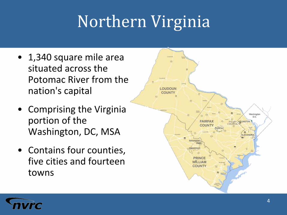
Northern Virginia
•
1,340 square mile area situated across the
Potomac River from the nation's capital
•
Comprising the Virginia portion of the
Washington, DC, MSA
•
Contains four counties, five cities and fourteen towns

5
Projected Growth
•
Northern Virginia has been
growing by about 35‐38,000
people per year, on average,
for more than 30 years
•
By 2020, its population will
reach 2.5 million
•
Population growth is
equivalent to adding a new
county every eight years, with
a population equivalent to the
number living in Loudoun
today—about 300,000
•
Pace of growth has continued
for more than 30 years
6
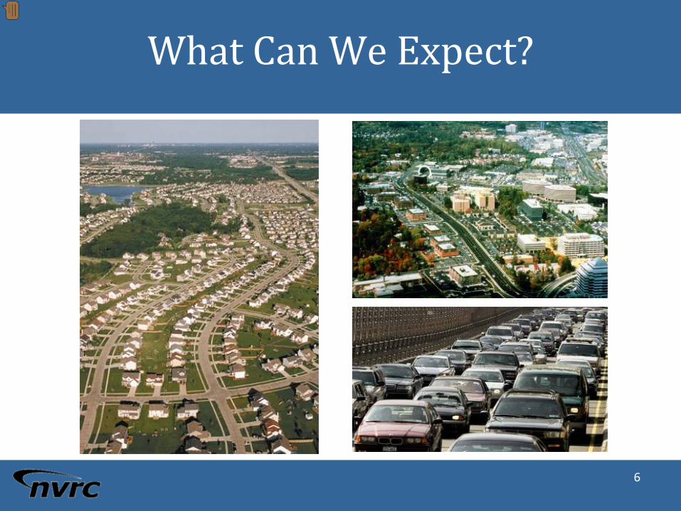
What Can We Expect?
7
Conservation Corridor Planningin Northern Virginia
Work collaboratively to:–
Refine state analyses using local data and priorities.
–
Identify & map high value cores and corridors across the
region.–
Highlight opportunities for regional connections.
–
Quantify benefits of these areas.
–
Develop model language for incorporation of GI/CC into
comprehensive planning efforts.–
Develop communication products and strategy for
promoting conservation opportunities to elected officials
and the public.

8
The ProcessPHASE I
•
Initiate working group
•
Develop draft maps
•
Construct draft policy language
PHASE II
•
Expand public participation
•
Finalize maps
•
Determine how best to refine at the local scale

9
Working Group
Arlington County Town of Clifton
Fairfax County Stafford County
Loudoun County Metropolitan Washington COG
Prince William County Virginia DCR
City of Alexandria Virginia DOT
Town of Dumfries Virginia DOF
City of Falls Church Maryland DNR
Town of Leesburg National Park Service – GWMP
City of Fairfax U.S. BLM
Town of Herndon U.S. FWS
City of Manassas US Army – Fort Belvoir
City of Manassas Park US Marine Corps ‐
Quantico
Town of Occoquan Northern Virginia Regional Park Authority
Town of Purcellville Prince William Conservation Alliance
Town of Quantico Northern Virginia Urban Forestry Roundtable
Town of Vienna Northern Virginia Conservation Trust
10
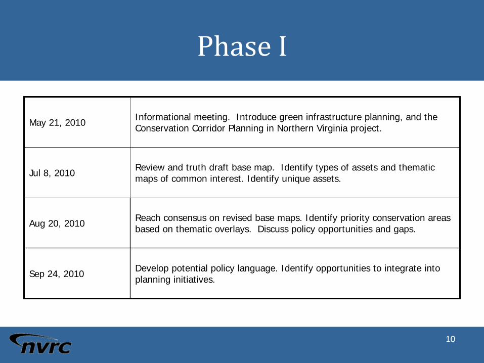
Phase I
May 21, 2010 Informational meeting. Introduce green infrastructure planning, and the Conservation Corridor Planning in Northern Virginia project.
Jul 8, 2010 Review and truth draft base map. Identify types of assets and thematic maps of common interest. Identify unique assets.
Aug 20, 2010 Reach consensus on revised base maps. Identify priority conservation areas based on thematic overlays. Discuss policy opportunities and gaps.
Sep 24, 2010 Develop potential policy language. Identify opportunities to integrate into planning initiatives.
11
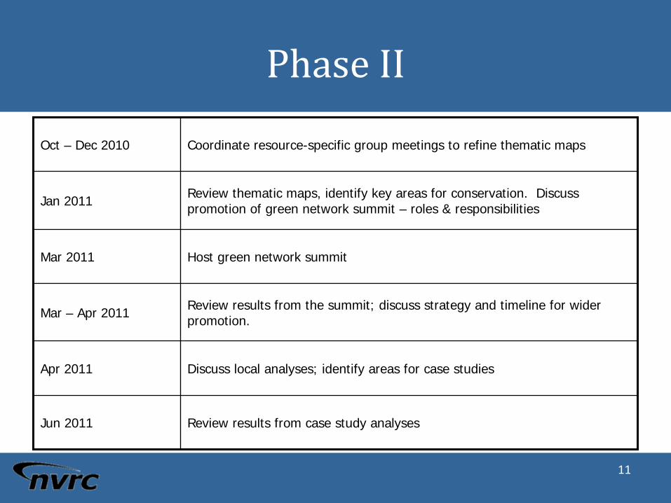
Phase II
Oct – Dec 2010 Coordinate resource-specific group meetings to refine thematic maps
Jan 2011 Review thematic maps, identify key areas for conservation. Discuss promotion of green network summit – roles & responsibilities
Mar 2011 Host green network summit
Mar – Apr 2011 Review results from the summit; discuss strategy and timeline for wider promotion.
Apr 2011 Discuss local analyses; identify areas for case studies
Jun 2011 Review results from case study analyses
12
13

14
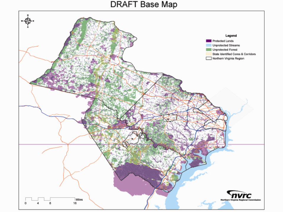
Developing a Regional Base MapData Sources
•
Virginia Department of Forestry – Land Cover & Forest Cover
•
Virginia Department of Conservation and Recreation –
Ecological Integrity Model, Natural Lands Network, Conserved
Lands
•
VCU‐CES –
Aquatic Resource Integrity Layer
•
USGS – National Hydrology Dataset
•
FWS – National Wetland Inventory
•
Local GIS Managers – CBPA, streams, parks, etc.

15
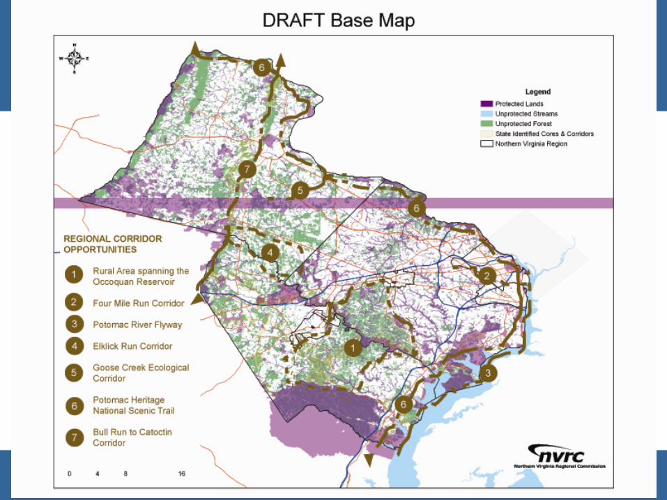
An example of a cross‐county
opportunity
DRAFT
16
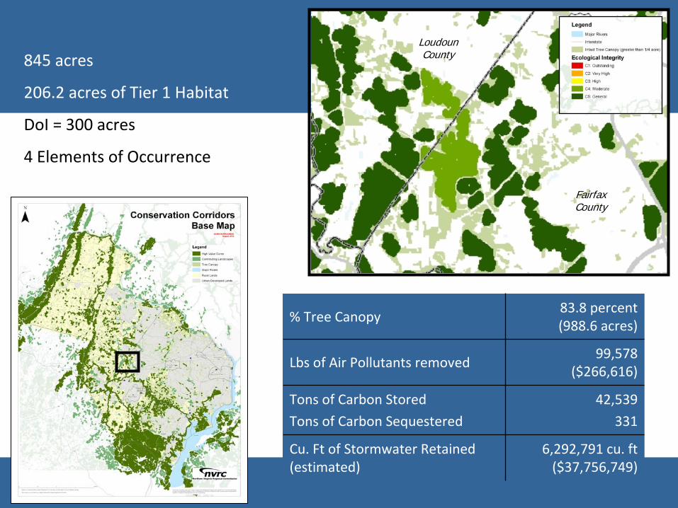
845 acres
206.2 acres of Tier 1 Habitat
DoI
= 300 acres
4 Elements of Occurrence
LoudounCounty
FairfaxCounty
% Tree Canopy83.8 percent
(988.6 acres)
Lbs of Air Pollutants removed99,578
($266,616)
Tons of Carbon Stored
Tons of Carbon Sequestered
42,539
331
Cu. Ft of Stormwater Retained
(estimated)
6,292,791 cu. ft
($37,756,749)
17
Next Steps &
Enlarged Participation

18
Theme Map Development
Theme Possible Participants Possible Datasets*
Water Quality
Restoration OpportunitiesDrinking Water Protection
Environmental PlannersWater Resource EngineersEcologistsStream Monitoring Project Managers
WatershedsStream QualityDrinking Water Sources, including Reservoirs
and recharge areasWellsCommunity WellsImpaired Streams (DEQ)
Nature-Based Recreation
Wildlife HabitatSignificant Flora and Fauna
Open Space ManagersNatural Resource ManagersPreserve ManagersPark ManagersNaturalists
Regional TrailsNature PreservesParks for Passive Recreation Important Birding Areas (?)Birding and Wildlife TrailsScenic Rivers / BluewaysPublicly accessible Conservation Lands
(WMAs, etc)Boat ramps (?)
Landscaped-based Cultural Heritage
Historic Resources
Cultural Heritage Resource ManagersArcheologistsBattlefield Preservationists?NPS – Manassas
Historic Districts and SitesBattlefieldsPre-historic RoadsPre-historic SettlementsHistoric Estates (i.e. Mt. Vernon, Oatlands)American Indian LandsHighway Markers
Agriculture
Maintain Rural Heritage
VA Tech Co-op ExtensionRural EDAs?Virginia DOFUSDA?PEC
Prime Ag SoilsAg-Forestal DistrictsAgri-tourism locations
WineriesPick-your-own
19
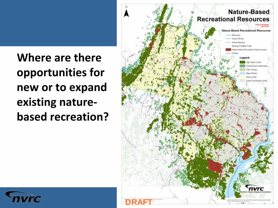
Where are there opportunities for new or to expand existing nature‐
based recreation?
DRAFT

20
Opportunities for Enhancing &
Protecting Water Quality
–
Streams
–
Drinking Water Sources
–
Wells
DRAFT

21
Opportunities for Conserving Our
Cultural Heritage
–
Historic Sites & Districts
–
Battlefields
DRAFT
22
Thank You! Questions?
Laura Grape
Sr. Environmental Planner
703‐642‐4625
Samantha Kinzer
Regional Planner
703‐642‐4636