Embed Size (px)
Citation preview
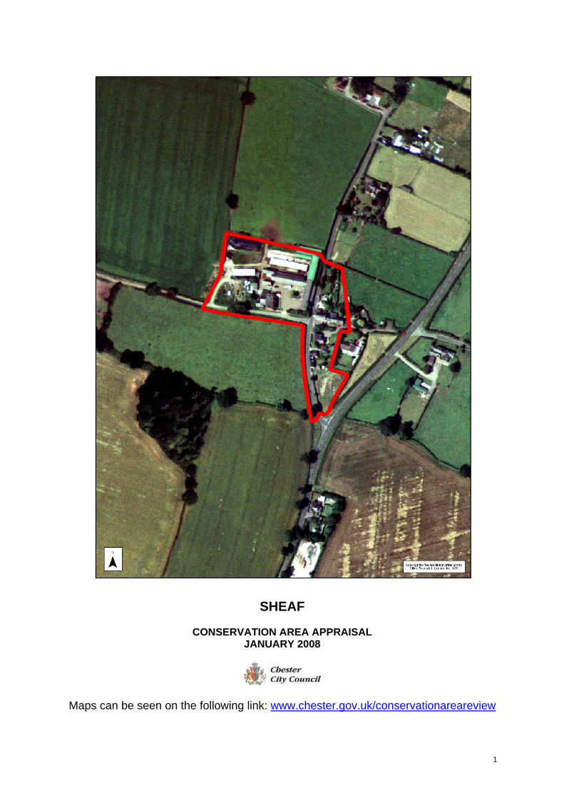
SHEAF
CONSERVATION AREA APPRAISAL JANUARY 2008
Maps can be seen on the following link: www.chester.gov.uk/conservationareareview
1
SHEAF CONSERVATION AREA APPRAISAL - JANUARY 2008 DESIGNATIONS Conservation Area First designated in 1974, alterations in 1996 Listed Buildings None Scheduled Monuments None Registered Parks and Gardens None Archaeological Priority None SSSI None Article 4 directions None Regulation 7 directions None Any other designations Area of Special County Value (ASCV) None Site of Biological Interest (SBI) None Site of Nature Conservation Value (SNCV) None Area of Nature Conservation Value (ANCV)
None
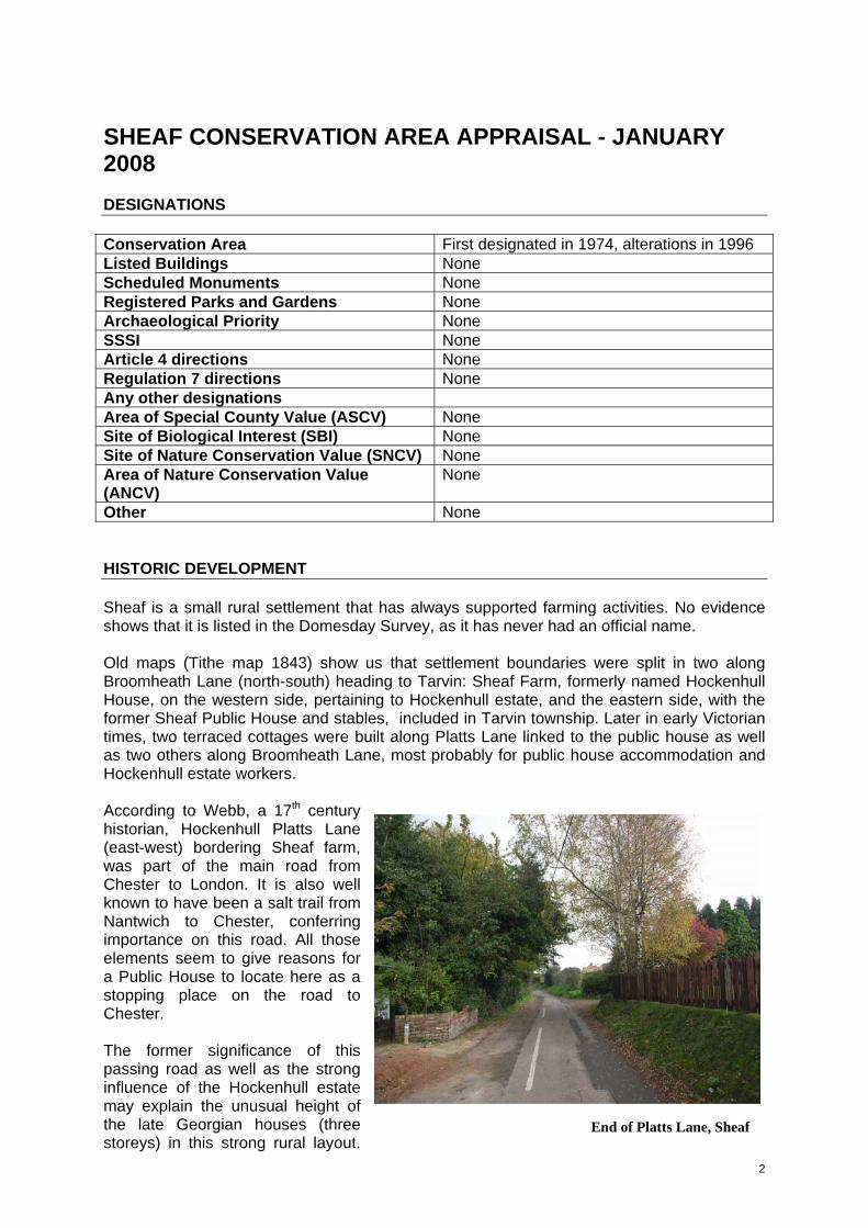
Other None HISTORIC DEVELOPMENT Sheaf is a small rural settlement that has always supported farming activities. No evidence shows that it is listed in the Domesday Survey, as it has never had an official name. Old maps (Tithe map 1843) show us that settlement boundaries were split in two along Broomheath Lane (north-south) heading to Tarvin: Sheaf Farm, formerly named Hockenhull House, on the western side, pertaining to Hockenhull estate, and the eastern side, with the former Sheaf Public House and stables, included in Tarvin township. Later in early Victorian times, two terraced cottages were built along Platts Lane linked to the public house as well as two others along Broomheath Lane, most probably for public house accommodation and Hockenhull estate workers. According to Webb, a 17th century historian, Hockenhull Platts Lane (east-west) bordering Sheaf farm, was part of the main road from Chester to London. It is also well known to have been a salt trail from Nantwich to Chester, conferring importance on this road. All those elements seem to give reasons for a Public House to locate here as a stopping place on the road to Chester.
2
The former significance of this passing road as well as the strong influence of the Hockenhull estate may explain the unusual height of the late Georgian houses (three storeys) in this strong rural layout.
End of Platts Lane, Sheaf
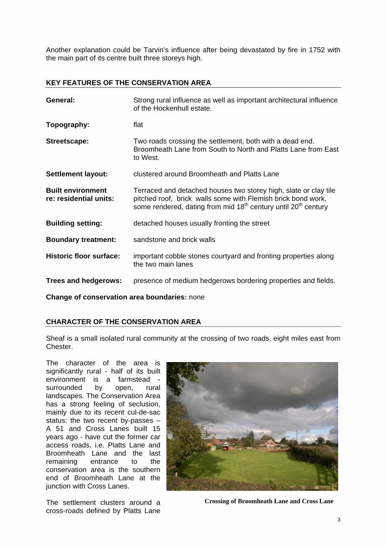
Another explanation could be Tarvin’s influence after being devastated by fire in 1752 with the main part of its centre built three storeys high. KEY FEATURES OF THE CONSERVATION AREA General: Strong rural influence as well as important architectural influence of the Hockenhull estate. Topography: flat Streetscape: Two roads crossing the settlement, both with a dead end. Broomheath Lane from South to North and Platts Lane from East to West. Settlement layout: clustered around Broomheath and Platts Lane Built environment Terraced and detached houses two storey high, slate or clay tile re: residential units: pitched roof, brick walls some with Flemish brick bond work, some rendered, dating from mid 18th century until 20th century Building setting: detached houses usually fronting the street Boundary treatment: sandstone and brick walls Historic floor surface: important cobble stones courtyard and fronting properties along the two main lanes Trees and hedgerows: presence of medium hedgerows bordering properties and fields. Change of conservation area boundaries: none CHARACTER OF THE CONSERVATION AREA Sheaf is a small isolated rural community at the crossing of two roads, eight miles east from Chester. The character of the area is significantly rural - half of its built environment is a farmstead - surrounded by open, rural landscapes. The Conservation Area has a strong feeling of seclusion, mainly due to its recent cul-de-sac status: the two recent by-passes – A 51 and Cross Lanes built 15 years ago - have cut the former car access roads, i.e. Platts Lane and Broomheath Lane and the last remaining entrance to the conservation area is the southern end of Broomheath Lane at the junction with Cross Lanes.
Crossing of Broomheath Lane and Cross Lane The settlement clusters around a cross-roads defined by Platts Lane
3
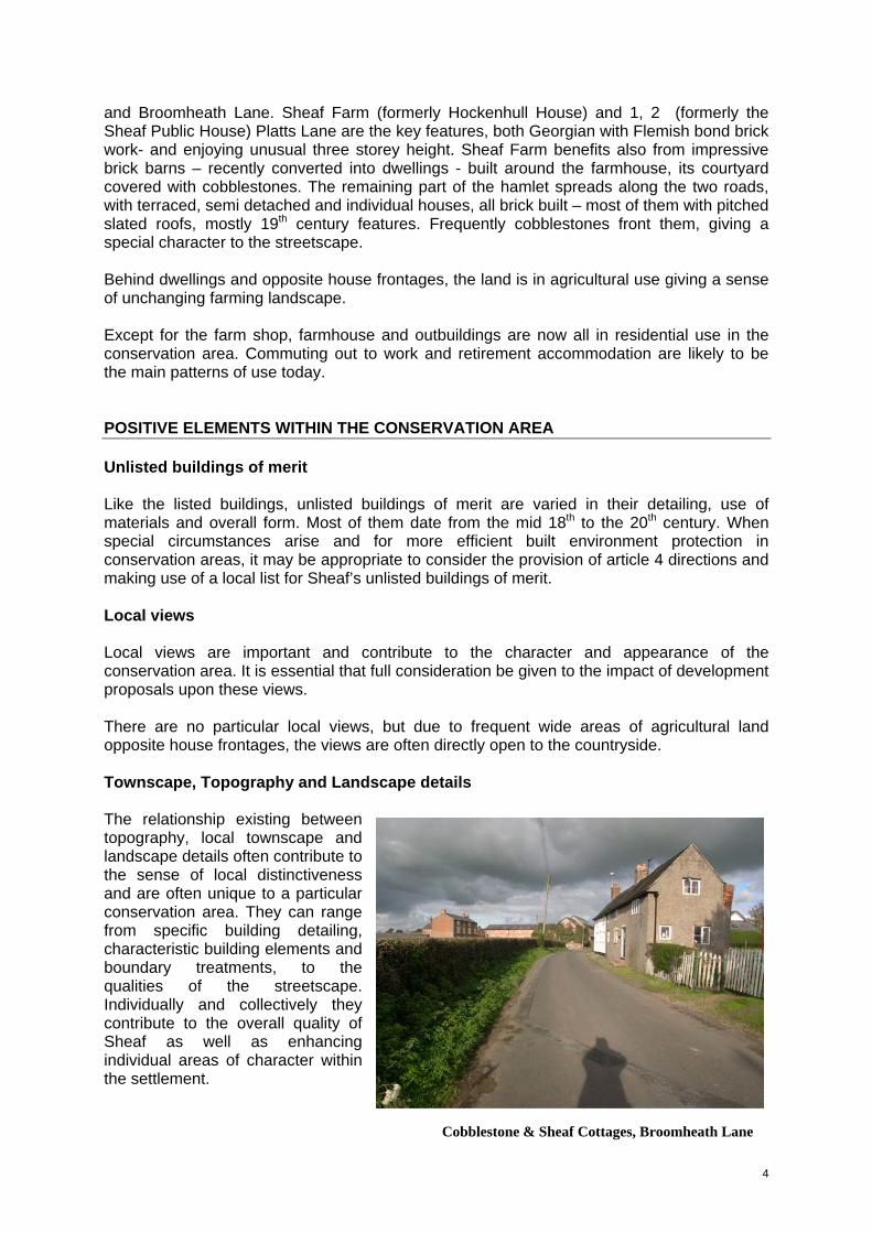
and Broomheath Lane. Sheaf Farm (formerly Hockenhull House) and 1, 2 (formerly the Sheaf Public House) Platts Lane are the key features, both Georgian with Flemish bond brick work- and enjoying unusual three storey height. Sheaf Farm benefits also from impressive brick barns – recently converted into dwellings - built around the farmhouse, its courtyard covered with cobblestones. The remaining part of the hamlet spreads along the two roads, with terraced, semi detached and individual houses, all brick built – most of them with pitched slated roofs, mostly 19th century features. Frequently cobblestones front them, giving a special character to the streetscape. Behind dwellings and opposite house frontages, the land is in agricultural use giving a sense of unchanging farming landscape. Except for the farm shop, farmhouse and outbuildings are now all in residential use in the conservation area. Commuting out to work and retirement accommodation are likely to be the main patterns of use today. POSITIVE ELEMENTS WITHIN THE CONSERVATION AREA Unlisted buildings of merit Like the listed buildings, unlisted buildings of merit are varied in their detailing, use of materials and overall form. Most of them date from the mid 18th to the 20th century. When special circumstances arise and for more efficient built environment protection in conservation areas, it may be appropriate to consider the provision of article 4 directions and making use of a local list for Sheaf’s unlisted buildings of merit. Local views Local views are important and contribute to the character and appearance of the conservation area. It is essential that full consideration be given to the impact of development proposals upon these views. There are no particular local views, but due to frequent wide areas of agricultural land opposite house frontages, the views are often directly open to the countryside. Townscape, Topography and Landscape details The relationship existing between topography, local townscape and landscape details often contribute to the sense of local distinctiveness and are often unique to a particular conservation area. They can range from specific building detailing, characteristic building elements and boundary treatments, to the qualities of the streetscape. Individually and collectively they contribute to the overall quality of Sheaf as well as enhancing individual areas of character within the settlement.
Cobblestone & Sheaf Cottages, Broomheath Lane
4
Topography Sheaf conservation area’s topography is mainly flat. Townscape details There are no distinctive local townscape details, but the following factors contribute strongly to the overall local distinctiveness as well as unifying the general layout:
• Unusual Georgian horizontal window openings • Pitched roofs with slate or clay tiles
Boundary treatments, hedgerows and trees Boundary treatments, hedgerows and trees have a significant impact upon the setting of properties, the coherence of a group and the overall character of a conservation area. Traditional and appropriate treatments will preserve or enhance the appearance of the conservation area. Boundary treatments The old walls - varying in height from 600mm to 2000mm -, sandstone or brick built add significantly to the townscape of the settlement, usually bordering residential frontages. It is worth mentioning the long sandstone wall (800 mm high) with triangular coping stones fronting Sheaf Farm’s main entrance, enhancing the importance of this property in the hamlet. Hedgerows and trees Hedgerows of medium height (1200mm to 1500mm) are predominantly present along Broomheath and Platts Lanes, bordering fields. Those hedgerows are a distinctive landmark to the pastoral appearance of Sheaf and should be preserved and maintained. Historic floor surface With the exception of the imposing Sheaf Farm courtyard covered with cobblestones, one metre of this material separates public highway from Victorian dwellings, (Platts Lane 1 to 4, Cobblestone and Sheaf Cottage). The significant presence of cobblestones in this settlement, very possibly extracted from the nearby Gowy River, adds particularly to the rural character of the area, giving a feeling of continuity from an earlier age.
5
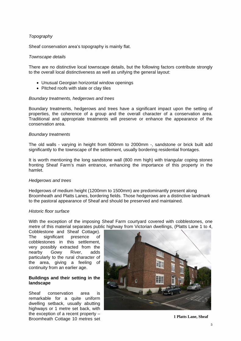
Buildings and their setting in the landscape Sheaf conservation area is remarkable for a quite uniform dwelling setback, usually abutting highways or 1 metre set back, with the exception of a recent property – Broomheath Cottage 10 metres set 1 Platts Lane, Sheaf
6
back from the street - and Sheaf barn conversion. Boundaries The boundaries have been reviewed and no changes have been proposed. NEUTRAL OR NEGATIVE ELEMENTS WITHIN THE CONSERVATION AREA AND ENHANCEMENT OPPORTUNITIES Neutral elements represent features within the conservation area that offer no strong positive or negative influence upon the character and appearance of the area. Furthermore, negative features detract from the special character of an area and present the opportunity for change, which will enhance the character and appearance of an area. Those elements considered neutral or negative features and those elements that represent enhancement opportunities within the conservation area are listed below. Neutral elements Platts Lane
• Broomheath Cottage, detached cottage late 1960 Negative elements Platts Lane
• Farm shop parking, lacking landscape design and using inappropriate materials (tarmac).
• Timber fence and hard standing opposite farm shop entrance (back of Sheaf courtyard west).
Enhancement opportunities Landscape improvement
• Farm shop parking, lacking landscape design and using inappropriate materials (tarmac).
To highlight the character and appearance of the area, the specification of traditional cobble stones or other traditional materials, rather than modern treatments, such as asphalt, in parking areas, driveways or yards, would benefit the conservation area as well, as a comprehensive landscape design for the farm shop parking.
• Timber fence and hard standing opposite farm shop entrance (extension of Sheaf courtyard west).
As mentioned previously the timber fence and hard standing opposite the farm shop entrance (extension of Sheaf courtyard west) adversely affects the character of the area. As a proposal to moderate the impact of this development, it would be desirable to build a dwarf wall in reclaimed Cheshire brick with coping stones. Traditional material fronting this development would be also better than the present yellow and grey concrete tiles. Buildings requiring attention
• Sheaf farmhouse and 1 Platts Lane, both Georgian dwellings, have poorly designed windows that affect adversely the rural character of the area.
7
It would benefit from carefully designed windows with traditional material (i.e. timber). It is hoped that funding to achieve these enhancements may be explored locally in due course. NB: These are suggestions for improvement, but owners should note that the Planning Authority has no powers to implement those recommendations. MANAGEMENT TOOLS In order to maintain the character and appearance of conservation areas, Chester City Council will use the appropriate pieces of legislation relevant for this task:
• Urgent Work Notice. This notice relates to a building which is in a very serious state of disrepair and needs basically to be water safe. It should be confirmed by the Secretary of State.
• Tidy Land Provision Notice, section 214 of the Planning Act 1990. This notice relates to a building and its curtilage that is poorly maintained. It requires a tidy up of the property.
• Dilapidated Building Notice, section 16 of the 1984 Building Act. This Notice refers to a building that is in a poor state. It implies either repairing the building or removal of the building. In a Conservation Area, such demolition would need a Conservation Area Consent.
THREAT Increasing car traffic - mainly due to commuting - with its side effects such as street widening, road signs, tree cutting, poorly designed garages and drive ways, inappropriate traffic calming measures, etc. often seriously and irreversibly affects the character of a conservation area. It is therefore important to foresee and manage very carefully the design and material impact of traffic on new developments, in order to maintain the essential features that make a conservation area special, in accordance with the latest guidance on streets published by the Department for Transport (Manual for Streets, March 2007, www.communities.gov.uk). SURROUNDING OF A CONSERVATION AREA Developments on properties located in the surroundings of a conservation area should also be considered with great care, in order to maintain the essential features that make an area special. APPENDICES
• Map of the conservation area as existing, scale 1:2,500 FURTHER READING Chester City Council - 1997 Living in a Conservation Area - A Guide to Householders Chester City Council - November 2006 Chester District Local Plan
8
Relevant Local Plan Policies
• ENV21 Protection of trees and woodland • ENV24 Preservation of key features within the landscape and its overall character • ENV37 Preservation or enhancement of conservation areas • ENV38 Protection of local views • ENV45 Preservation of the special interest of listed buildings • ENV46 Appropriate changes of use to listed buildings • ENV47 Protection of unlisted buildings of merit