Embed Size (px)
Citation preview
Mongabay.com Open Access Journal - Tropical Conservation Science Vol.5 (1):38-49, 2012
Tropical Conservation Science | ISSN 1940-0829 | Tropicalconservationscience.org
38
Research Article
Biological diversity and management regimes of the
northern Barandabhar Forest Corridor: an essential habitat for ecological connectivity in Nepal Achyut Aryal1,2*, Dianne Brunton1, Ram Pandit3 ,Tej Kumar Shrestha2,
Jennie Lord4 , Raj Kumar Koirala5,6, Yam Bahadur Thapa7, Bikash
Adhikari6,2, Weihong Ji1 and David Raubenheimer5
1Ecology & Conservation Group, Institute of Natural Sciences, Massey University, New Zealand; 2Biodiversity Research and Training Forum Nepal/Fauna and Flora Conservation Nepal; 3School of Agricultural and Resource Economics, Faculty of Natural and Agricultural Sciences, The University of Western Australia, Australia; 4URS Scott Wilson, Environment & Natural Resources, Manchester, UK; 5Nutritional Ecology Research Group, Institute of Natural Sciences, Massey University, New Zealand; 6Institute of Forestry, Tribhuvan University, Pokhara, Nepal; 7Department of Forest, Ministry of Forests and Soil conservation, Nepal. *Corresponding author: [email protected]
Abstract Despite the development of progressive policies in forestry and wildlife management sectors in Nepal, over the last ten years it has become clear that protected areas in the country lack the landscape connectivity required to support viable populations of endangered species such as rhino (Rhinoceros unicornis) and tiger (Panthera tigris tigris). Forest resources that provide essential habitat for a diverse array of species, and forest products to many human populations continue to decline. The present study, focusing upon the northern Barandabhar Forest Corridor (BFC) aimed to begin to address these problems by establishing preliminary data concerning the extent, biological diversity and resources available for local communities of the forest in order to promote a community-based management strategy. Results established that the northern BFC covers an area of 10,644 ha between the East-West Mahendra highway and the Mahabharat range, incorporating 15 community forestry areas (3,184 ha). It was found to support a number of IUCN listed threatened and endangered species including rhino and tiger; and contains suitable habitat for a number of other endangered species. Owing to its connectivity, linking Chitwan National Park with the Mahabharat range, BFC has the potential to make an important contribution to improving the ecological integrity in Nepal. Different institutions and governance structures currently exist to manage the northern BFC. Although these institutions differ in resource utilization and benefit sharing mechanisms, they are united to safeguard the habitat of key wildlife species including rhino and tiger. We propose that the northern BFC should be managed through a new participatory scheme, the Barandabhar Forest Management Council, to foster ecological integrity of the area while providing forest products to communities. Keywords: connectivity, corridor, Barandabhar forest, community forestry, Rhino, Tiger.
Received: 18 October 2011; Accepted: 2 January 2012; Published: 19 March 2012. Copyright: © Aryal, A., Brunton, D., Pandit, R., Shrestha, T.K., Lord, J. , Koirala, R.K., Thapa, Y.B., Adhikari, B., Ji, W., and Raubenheimer, D.This is an open access paper. We use the Creative Commons Attribution 3.0 license http://creativecommons.org/licenses/by/3.0/ - The license permits any user to download, print out, extract, archive, and distribute the article, so long as appropriate credit is given to the authors and source of the work. The license ensures that the published article will be as widely available as possible and that the article can be included in any scientific archive. Open Access authors retain the copyrights of their papers. Open access is a property of individual works, not necessarily journals or publishers.
Cite this paper as: Aryal, A., Brunton, D., Pandit, R., Shrestha, T.K., Lord, J., Koirala, R.K., Thapa, Y.B., Adhikari, B., Ji, W., and Raubenheimer, D. 2012. Biological Diversity and Management Regimes of the Northern Barandabhar Forest Corridor: An Essential Habitat for Ecological Connectivity in Nepal. Tropical Conservation Science Vol. 5(1):38-49. Available online: www.tropicalconservationscience.org
Mongabay.com Open Access Journal - Tropical Conservation Science Vol.5 (1):38-49, 2012
Tropical Conservation Science | ISSN 1940-0829 | Tropicalconservationscience.org 39
Introduction The Barandabhar Forest Corridor (BFC) lies between Chitwan National Park (CNP) and the Mahabharat range within the Terai Arc Landscape of Nepal (Fig. 1). Approximately 75% of this landscape was previously forested, supporting a rich diversity of flora and fauna [1-2]. Since the 1950’s however, the area has been subject to deforestation. This is largely due to an influx of people attracted by the fertile soils and to the launch of the Rapti Doon Development Programme, which encouraged deforestation for agriculture and the conversion of private forest to national forest [3-7]. Consequently, the BFC is the only remaining natural forest that connects the CNP and Chure Siwalik range with the Mahabharat
range [8-10], allowing the endangered one-horned rhinoceros (Rhinoceros unicornis hereafter ‘rhino’) and Royal Bengal tiger (Panthera tigris tigris hereafter ‘tiger’) access to refuge at higher altitudes during monsoon seasons [11]. Retention and restoration of such ecological corridors, linking protected areas, are considered essential in maintaining and restoring wildlife populations across south and central Asia [11]. Despite the potential importance of the BFC for protected species, including rhino and tiger, there is currently a dearth in published literature with respect to the biodiversity of the area and the use of the corridor by these keystone species. Indeed, even baseline information such as the extent of the northern BFC and its boundaries is lacking. In addition to a lack of ecological data for the area, two further issues have been reported to currently restrict the potential to manage the BFC as a functioning ecological corridor [8-10]. Firstly, the East-West Mahendra Highway bisects the BFC and its volume and speed of traffic, may pose a barrier to wildlife movement [8, 9, 10, 11]. Secondly, the BFC to the south of the highway is included within the CNP buffer zone, managed by the Buffer Zone Development Council, whereas the northern extent is in the Department of Forests ownership, and therefore management regimes for the two areas of forest are currently inconsistent [8-11]. In order to begin to resolve these issues, the aim of the current study was to determine the exact area of the northern BFC and undertake preliminary surveys of its biological diversity and resources available for local communities. These data will be used to decide how best to manage the area with respect to its ecological, economic and cultural resources, through a management plan that will engage and involve local stakeholders. In Nepal, forests are considered a “social space.” Therefore, a community-based conservation approach to forest management has been promoted since the early 1980’s [12-13]. In other areas, this approach has had a positive impact on forest cover, slowed rates of deforestation, restored denuded mountain landscapes, and has been shown to be favored by local communities, compared with traditional parks and reserve management [13-16]. A community-based approach to management of the northern BFC is therefore proposed in this paper, with particular emphasis on conservation of rhino and tiger. It is envisaged that by employing participatory forest management in the northern BFC, government agencies (for instance, the Department of Forests and the Department of National Parks and Wildlife Conservation) will be able to engage local stakeholders, including forest-dependent communities, to prevent internal and external threats to the conservation of the entire BFC.
Mongabay.com Open Access Journal - Tropical Conservation Science Vol.5 (1):38-49, 2012
Tropical Conservation Science | ISSN 1940-0829 | Tropicalconservationscience.org 40
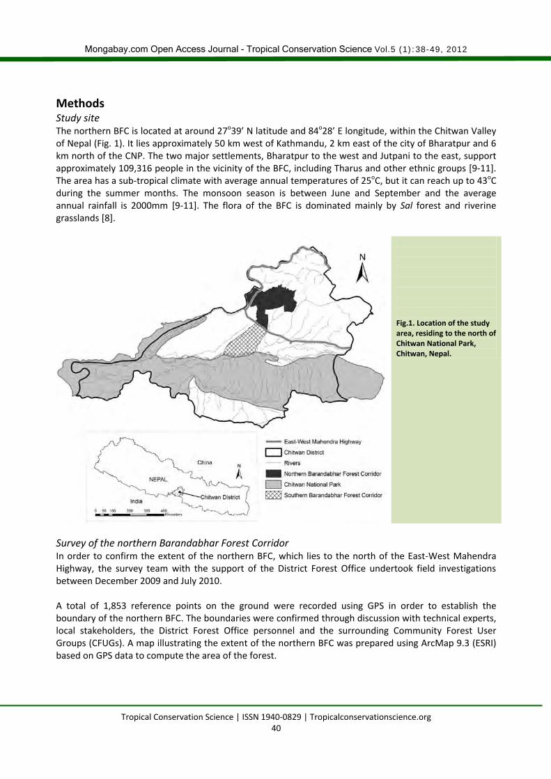
Methods Study site The northern BFC is located at around 27o39’ N latitude and 84o28’ E longitude, within the Chitwan Valley of Nepal (Fig. 1). It lies approximately 50 km west of Kathmandu, 2 km east of the city of Bharatpur and 6 km north of the CNP. The two major settlements, Bharatpur to the west and Jutpani to the east, support approximately 109,316 people in the vicinity of the BFC, including Tharus and other ethnic groups [9-11]. The area has a sub-tropical climate with average annual temperatures of 25oC, but it can reach up to 43oC during the summer months. The monsoon season is between June and September and the average annual rainfall is 2000mm [9-11]. The flora of the BFC is dominated mainly by Sal forest and riverine grasslands [8].
Fig.1. Location of the study area, residing to the north of Chitwan National Park, Chitwan, Nepal.
Survey of the northern Barandabhar Forest Corridor In order to confirm the extent of the northern BFC, which lies to the north of the East-West Mahendra Highway, the survey team with the support of the District Forest Office undertook field investigations between December 2009 and July 2010. A total of 1,853 reference points on the ground were recorded using GPS in order to establish the boundary of the northern BFC. The boundaries were confirmed through discussion with technical experts, local stakeholders, the District Forest Office personnel and the surrounding Community Forest User Groups (CFUGs). A map illustrating the extent of the northern BFC was prepared using ArcMap 9.3 (ESRI) based on GPS data to compute the area of the forest.
Mongabay.com Open Access Journal - Tropical Conservation Science Vol.5 (1):38-49, 2012
Tropical Conservation Science | ISSN 1940-0829 | Tropicalconservationscience.org 41
Vegetation and biodiversity survey During field investigations, data on forest type and structure, biomass, growing stock and current resource use (such as grass, fuel wood and non-timber forest products) were documented according to the Community Forest Inventory Guidelines 2004 [17]. A total of 389 sample plots of 20m x 20m were surveyed at intervals ranging from 200m to 500m along 49 transects through the forest from west to east. The width of each transect was 50m and the length ranged from 1km to 10km, depending on the distance between the west and east forest boundaries. Locations of plots were recorded with GPS. The surveys distinguished between the following forest types: Sal, mixed, Padke (Albizia lucida) and Khair-Sissoo (Acacia catechu and Dalbergia sissoo) as detailed within the Community Forest Inventory Guidelines [17]. Within each plot, plants were identified either on site or after further examination at the National Herbarium and Plant Laboratories in Kathmandu. The height and DBH (diameter at breast height) of trees (>30cm DBH) in each sample plot were recorded. In each sample plot, the number of poles (10-29.9cm DBH), saplings (>1m height and <9.9cm DBH) and seedlings (<1m height) were counted using smaller plots of size 10m x 10m, 5m x 5m and 1m x 1m respectively. The Community Forest Inventory Guidelines 2004 [17] were followed to calculate frequency, density and volume of trees in each sample plot i.e. Volume = 3.14 x 1/4DBH2 x form factor (0.5) x tree quality index. [17]. The location and extent of wetland and grassland areas inside the BFC were also recorded using GPS. A preliminary survey of wildlife present within the forest and associated wetland and grassland habitats consisted of recording direct sightings of bird and mammal species along each transect. In addition, a pugmark, dung, scat and pellet survey was undertaken along each transect, in order to establish evidence for the presence of mammals, in particular rhino and tiger. As supplementary evidence, local people (N=274) from different communities adjacent to the forest were interviewed to better understand the number and circumstances of rhino and tiger sightings in the area.
Interaction with local stakeholders In each local community (N=6), a one day workshop was organized to understand the local people’s knowledge and experience on traditional wildlife management approaches and their perception of wildlife management in general. Management options were devised following consultation with the concerned stakeholders (Community Forest User Group, Leasehold User Group, concerned Government Departments, and NGOs) through a series of discussion workshops based on findings of the survey. Management options aimed at internalizing and minimizing any future resource use issues that could be encountered in the next 5 years. Available literature [5-19] was also reviewed to prepare the management plan for the study area.
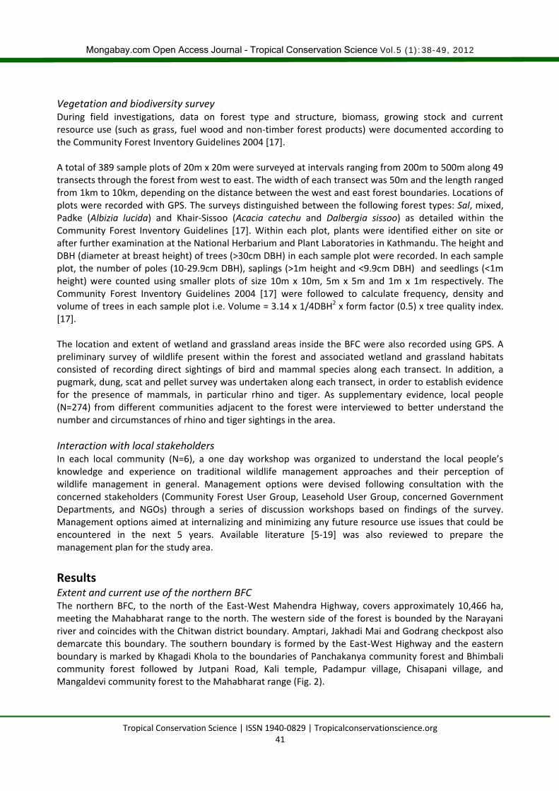
Results Extent and current use of the northern BFC The northern BFC, to the north of the East-West Mahendra Highway, covers approximately 10,466 ha, meeting the Mahabharat range to the north. The western side of the forest is bounded by the Narayani river and coincides with the Chitwan district boundary. Amptari, Jakhadi Mai and Godrang checkpost also demarcate this boundary. The southern boundary is formed by the East-West Highway and the eastern boundary is marked by Khagadi Khola to the boundaries of Panchakanya community forest and Bhimbali community forest followed by Jutpani Road, Kali temple, Padampur village, Chisapani village, and Mangaldevi community forest to the Mahabharat range (Fig. 2).
Mongabay.com Open Access Journal - Tropical Conservation Science Vol.5 (1):38-49, 2012
Tropical Conservation Science | ISSN 1940-0829 | Tropicalconservationscience.org 42
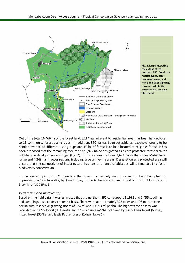
Fig. 2. Map illustrating the extent of the northern BFC. Dominant habitat types, core protected areas, and rhino and tiger sightings recorded within the northern BFC are also illustrated.
Out of the total 10,466 ha of the forest land, 3,184 ha, adjacent to residential areas has been handed over to 15 community forest user groups. In addition, 350 ha has been set aside as leasehold forests to be handed over to 65 different user groups and 10 ha of forest is to be allocated as religious forest. It has been proposed that the remaining core zone of 6,922 ha be designated as a core protected forest area for wildlife, specifically rhino and tiger (Fig. 2). This core area includes 2,673 ha in the upper Mahabharat range and 4,249 ha in lower regions, including several riverine areas. Designation as a protected area will ensure that the connectivity of intact natural habitats at a range of altitudes will be managed to foster biodiversity conservation. In the eastern part of BFC boundary the forest connectivity was observed to be interrupted for approximately 1km in width, by 8km in length, due to human settlement and agricultural land uses at Shaktikhor VDC (Fig. 3).
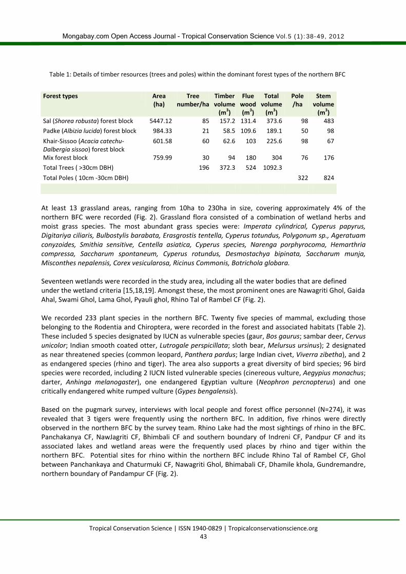
Vegetation and biodiversity Based on the field data, it was estimated that the northern BFC can support 11,985 and 1,455 seedlings and samplings respectively on per ha basis. There were approximately 322 poles and 196 mature trees per ha with respective growing stocks of 824 m3 and 1092.3 m3 per ha. The highest tree density was recorded in the Sal forest (93 tree/ha and 373.6 volume m3 /ha) followed by Sisso- Khair forest (60/ha), mixed forest (30/ha) and lastly Padke forest (21/ha) (Table 1).
Mongabay.com Open Access Journal - Tropical Conservation Science Vol.5 (1):38-49, 2012
Tropical Conservation Science | ISSN 1940-0829 | Tropicalconservationscience.org 43
Table 1: Details of timber resources (trees and poles) within the dominant forest types of the northern BFC
Forest types Area
(ha) Tree
number/ha Timber volume
(m3)
Flue wood (m3)
Total volume
(m3)
Pole /ha
Stem volume
(m3) Sal (Shorea robusta) forest block 5447.12 85 157.2 131.4 373.6 98 483
Padke (Albizia lucida) forest block 984.33 21 58.5 109.6 189.1 50 98
Khair-Sissoo (Acacia catechu- Dalbergia sissoo) forest block
601.58 60 62.6 103 225.6 98 67
Mix forest block 759.99 30 94 180 304 76 176
Total Trees ( >30cm DBH) 196 372.3 524 1092.3
Total Poles ( 10cm -30cm DBH) 322 824
At least 13 grassland areas, ranging from 10ha to 230ha in size, covering approximately 4% of the northern BFC were recorded (Fig. 2). Grassland flora consisted of a combination of wetland herbs and moist grass species. The most abundant grass species were: Imperata cylindrical, Cyperus papyrus, Digitariya ciliaris, Bulbostylis barabata, Erasgrostis tentella, Cyperus totundus, Polygonum sp., Ageratuam conyzoides, Smithia sensitive, Centella asiatica, Cyperus species, Narenga porphyrocoma, Hemarthria compressa, Saccharum spontaneum, Cyperus rotundus, Desmostachya bipinata, Saccharum munja, Misconthes nepalensis, Corex vesicularosa, Ricinus Commonis, Botrichola globara. Seventeen wetlands were recorded in the study area, including all the water bodies that are defined under the wetland criteria [15,18,19]. Amongst these, the most prominent ones are Nawagriti Ghol, Gaida Ahal, Swami Ghol, Lama Ghol, Pyauli ghol, Rhino Tal of Rambel CF (Fig. 2). We recorded 233 plant species in the northern BFC. Twenty five species of mammal, excluding those belonging to the Rodentia and Chiroptera, were recorded in the forest and associated habitats (Table 2). These included 5 species designated by IUCN as vulnerable species (gaur, Bos gaurus; sambar deer, Cervus unicolor; Indian smooth coated otter, Lutrogale perspicillata; sloth bear, Melursus ursinus); 2 designated as near threatened species (common leopard, Panthera pardus; large Indian civet, Viverra zibetha), and 2 as endangered species (rhino and tiger). The area also supports a great diversity of bird species; 96 bird species were recorded, including 2 IUCN listed vulnerable species (cinereous vulture, Aegypius monachus; darter, Anhinga melanogaster), one endangered Egyptian vulture (Neophron percnopterus) and one critically endangered white rumped vulture (Gypes bengalensis). Based on the pugmark survey, interviews with local people and forest office personnel (N=274), it was revealed that 3 tigers were frequently using the northern BFC. In addition, five rhinos were directly observed in the northern BFC by the survey team. Rhino Lake had the most sightings of rhino in the BFC. Panchakanya CF, NawJagriti CF, Bhimbali CF and southern boundary of Indreni CF, Pandpur CF and its associated lakes and wetland areas were the frequently used places by rhino and tiger within the northern BFC. Potential sites for rhino within the northern BFC include Rhino Tal of Rambel CF, Ghol between Panchankaya and Chaturmuki CF, Nawagriti Ghol, Bhimabali CF, Dhamile khola, Gundremandre, northern boundary of Pandampur CF (Fig. 2).
Mongabay.com Open Access Journal - Tropical Conservation Science Vol.5 (1):38-49, 2012
Tropical Conservation Science | ISSN 1940-0829 | Tropicalconservationscience.org 44
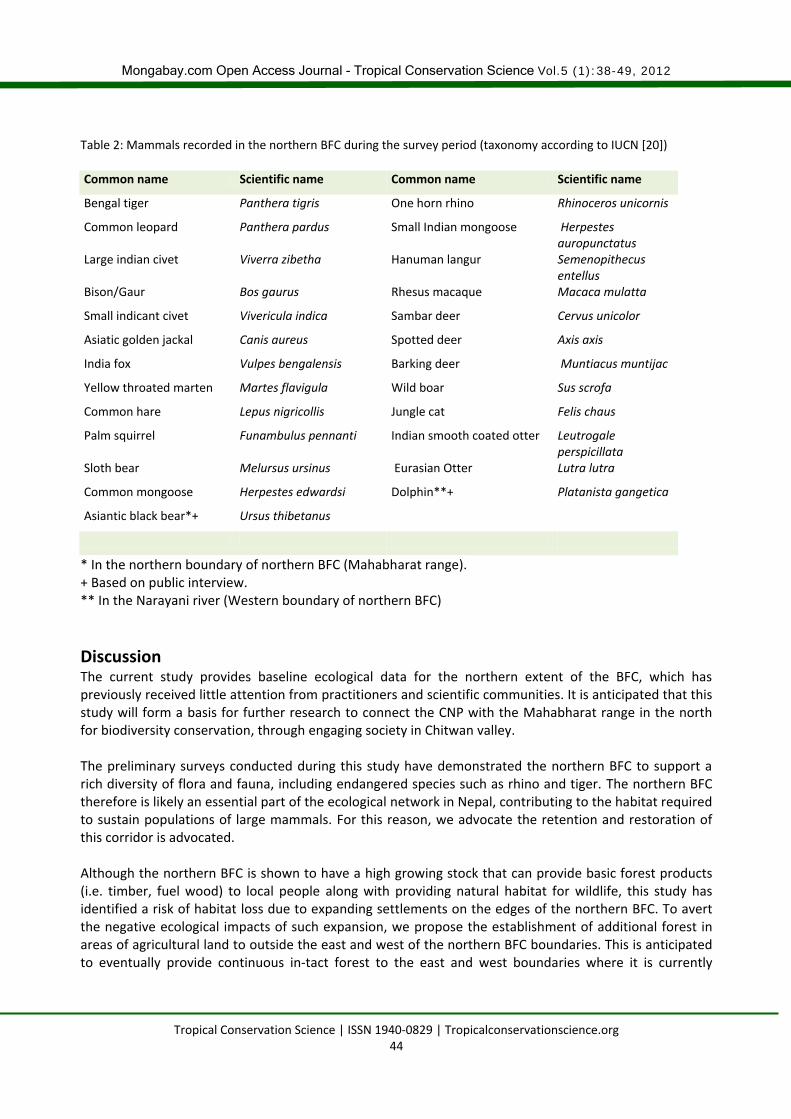
Table 2: Mammals recorded in the northern BFC during the survey period (taxonomy according to IUCN [20]) Common name Scientific name Common name Scientific name
Bengal tiger Panthera tigris One horn rhino Rhinoceros unicornis
Common leopard Panthera pardus Small Indian mongoose Herpestes auropunctatus
Large indian civet Viverra zibetha Hanuman langur Semenopithecus entellus
Bison/Gaur Bos gaurus Rhesus macaque Macaca mulatta
Small indicant civet Vivericula indica Sambar deer Cervus unicolor
Asiatic golden jackal Canis aureus Spotted deer Axis axis
India fox Vulpes bengalensis Barking deer Muntiacus muntijac
Yellow throated marten Martes flavigula Wild boar Sus scrofa
Common hare Lepus nigricollis Jungle cat Felis chaus
Palm squirrel Funambulus pennanti Indian smooth coated otter Leutrogale perspicillata
Sloth bear Melursus ursinus Eurasian Otter Lutra lutra
Common mongoose Herpestes edwardsi Dolphin**+ Platanista gangetica
Asiantic black bear*+ Ursus thibetanus
* In the northern boundary of northern BFC (Mahabharat range). + Based on public interview. ** In the Narayani river (Western boundary of northern BFC)
Discussion The current study provides baseline ecological data for the northern extent of the BFC, which has previously received little attention from practitioners and scientific communities. It is anticipated that this study will form a basis for further research to connect the CNP with the Mahabharat range in the north for biodiversity conservation, through engaging society in Chitwan valley. The preliminary surveys conducted during this study have demonstrated the northern BFC to support a rich diversity of flora and fauna, including endangered species such as rhino and tiger. The northern BFC therefore is likely an essential part of the ecological network in Nepal, contributing to the habitat required to sustain populations of large mammals. For this reason, we advocate the retention and restoration of this corridor is advocated. Although the northern BFC is shown to have a high growing stock that can provide basic forest products (i.e. timber, fuel wood) to local people along with providing natural habitat for wildlife, this study has identified a risk of habitat loss due to expanding settlements on the edges of the northern BFC. To avert the negative ecological impacts of such expansion, we propose the establishment of additional forest in areas of agricultural land to outside the east and west of the northern BFC boundaries. This is anticipated to eventually provide continuous in-tact forest to the east and west boundaries where it is currently
Mongabay.com Open Access Journal - Tropical Conservation Science Vol.5 (1):38-49, 2012
Tropical Conservation Science | ISSN 1940-0829 | Tropicalconservationscience.org 45
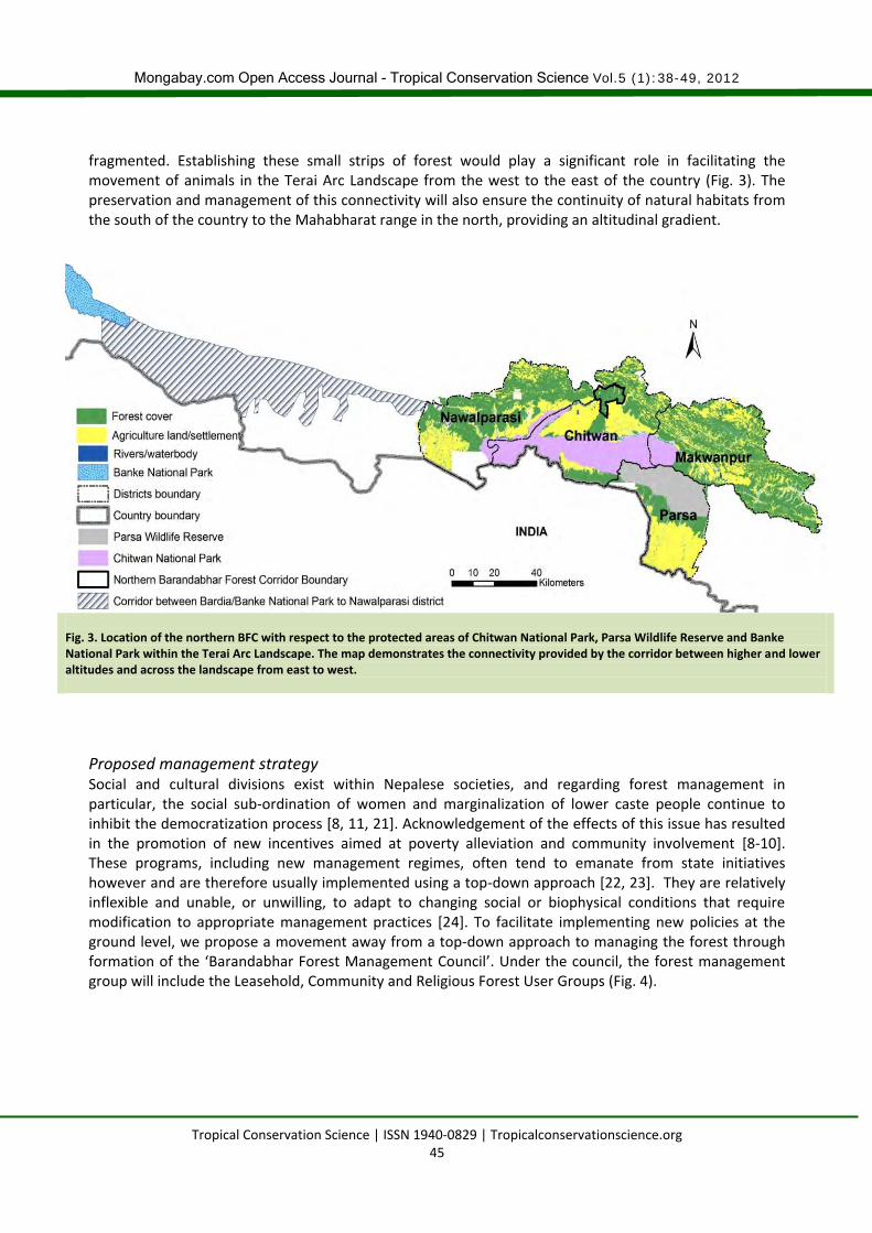
fragmented. Establishing these small strips of forest would play a significant role in facilitating the movement of animals in the Terai Arc Landscape from the west to the east of the country (Fig. 3). The preservation and management of this connectivity will also ensure the continuity of natural habitats from the south of the country to the Mahabharat range in the north, providing an altitudinal gradient.
Fig. 3. Location of the northern BFC with respect to the protected areas of Chitwan National Park, Parsa Wildlife Reserve and Banke National Park within the Terai Arc Landscape. The map demonstrates the connectivity provided by the corridor between higher and lower altitudes and across the landscape from east to west.
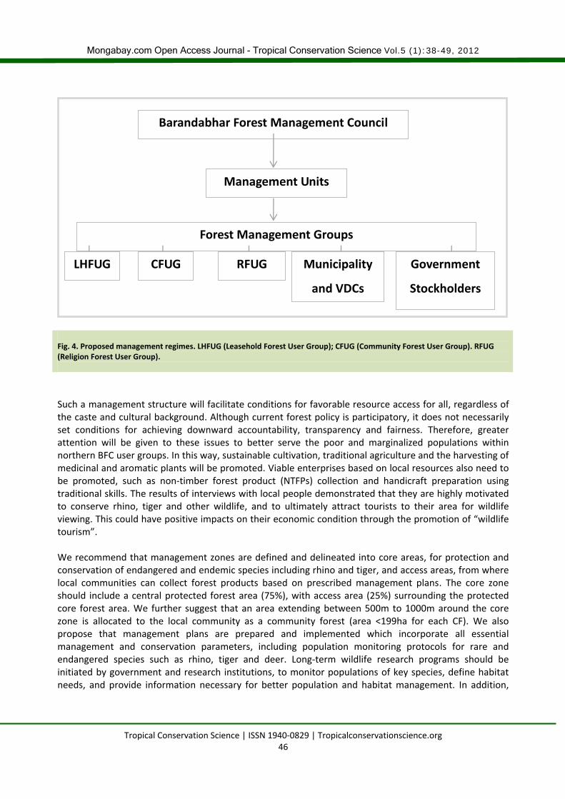
Proposed management strategy Social and cultural divisions exist within Nepalese societies, and regarding forest management in particular, the social sub-ordination of women and marginalization of lower caste people continue to inhibit the democratization process [8, 11, 21]. Acknowledgement of the effects of this issue has resulted in the promotion of new incentives aimed at poverty alleviation and community involvement [8-10]. These programs, including new management regimes, often tend to emanate from state initiatives however and are therefore usually implemented using a top-down approach [22, 23]. They are relatively inflexible and unable, or unwilling, to adapt to changing social or biophysical conditions that require modification to appropriate management practices [24]. To facilitate implementing new policies at the ground level, we propose a movement away from a top-down approach to managing the forest through formation of the ‘Barandabhar Forest Management Council’. Under the council, the forest management group will include the Leasehold, Community and Religious Forest User Groups (Fig. 4).
Mongabay.com Open Access Journal - Tropical Conservation Science Vol.5 (1):38-49, 2012
Tropical Conservation Science | ISSN 1940-0829 | Tropicalconservationscience.org 46
Fig. 4. Proposed management regimes. LHFUG (Leasehold Forest User Group); CFUG (Community Forest User Group). RFUG (Religion Forest User Group).
Such a management structure will facilitate conditions for favorable resource access for all, regardless of the caste and cultural background. Although current forest policy is participatory, it does not necessarily set conditions for achieving downward accountability, transparency and fairness. Therefore, greater attention will be given to these issues to better serve the poor and marginalized populations within northern BFC user groups. In this way, sustainable cultivation, traditional agriculture and the harvesting of medicinal and aromatic plants will be promoted. Viable enterprises based on local resources also need to be promoted, such as non-timber forest product (NTFPs) collection and handicraft preparation using traditional skills. The results of interviews with local people demonstrated that they are highly motivated to conserve rhino, tiger and other wildlife, and to ultimately attract tourists to their area for wildlife viewing. This could have positive impacts on their economic condition through the promotion of “wildlife tourism”. We recommend that management zones are defined and delineated into core areas, for protection and conservation of endangered and endemic species including rhino and tiger, and access areas, from where local communities can collect forest products based on prescribed management plans. The core zone should include a central protected forest area (75%), with access area (25%) surrounding the protected core forest area. We further suggest that an area extending between 500m to 1000m around the core zone is allocated to the local community as a community forest (area <199ha for each CF). We also propose that management plans are prepared and implemented which incorporate all essential management and conservation parameters, including population monitoring protocols for rare and endangered species such as rhino, tiger and deer. Long-term wildlife research programs should be initiated by government and research institutions, to monitor populations of key species, define habitat needs, and provide information necessary for better population and habitat management. In addition,
Barandabhar Forest Management Council
Management Units
Forest Management Groups
LHFUG Municipality
and VDCs
Government
Stockholders
RFUG CFUG
Mongabay.com Open Access Journal - Tropical Conservation Science Vol.5 (1):38-49, 2012
Tropical Conservation Science | ISSN 1940-0829 | Tropicalconservationscience.org 47
detailed surveys are also required for fauna that were not recorded in this study including rodents, bats and migratory birds. The maintenance and enhancement of the floral diversity of the area including NTFPs by effectively limiting their overexploitation is also a management requirement. For rhino and tiger specifically, detailed surveys should be undertaken in the hotspots identified in the present study. Comprehensive guidelines for the overall biodiversity management in the northern BFC should be prepared and implemented in coordination with the relevant local communities. Each community forest on the edges of northern BFC should delineate areas to promote natural vegetation and restore open areas with planting of indigenous grass and other plant species that can provide suitable habitat for wildlife. The collection of timber, fuel wood, fodder and NTFPs from degraded areas should be strictly controlled. However, local communities should be encouraged toward sustainable use of forest resources through guidelines imbedded in their community forest plans. In doing so, private households in the fringe areas of northern BFC should be supported by government in the production and distribution of trees, NTFPs and seedlings/cuttings. In the forest area, re-planting should be undertaken where planting targets have not been achieved, and suitable silvicultural treatments should also be introduced to manage plantations. Practical and viable systems should be established to regulate grazing by introducing the concept of rotational grazing in degraded and vulnerable areas. The forest should be subject to ecological survey periodically every five years to update information on existing grassland, forest and wetland areas associated with the northern BFC. A standard survey method should be developed as per the government guidelines of 2004 [17]. The introduction of exotic species should be regulated in coordination with the governmental and non-governmental agencies operating in the northern BFC.
A ban on livestock grazing in the core zones of the northern BFC should be implemented and strictly enforced. The habitat and nesting sites of important resident and migratory birds should be mapped out. Patches of degraded forest should be protected for rehabilitation according to the Operational Plan and encourage CFUG should be encouraged to integrate sustainable ways of traditional forest management and control systems. Required technical support should be provided to the northern BFC management committee to implement management activities effectively.
The East-West Mahendra Highway that bisects the BFC presents a risk to wildlife movement across two sides of BFC. Wildlife monitoring has indicated that at least 5-6 animals/year have been killed due to road accidents on this stretch of the highway [11]. Additionally, light and noise associated with heavy traffic causes considerable disturbance in the movement of wildlife between the two sides of the BFC. It is therefore essential to establish alternative paths for wildlife to cross the highway safely, in the form of bridges or tunnels. In addition, a camera enforced speed limit could be introduced along with a campaign raising awareness for drivers to reduce wildlife accidents.
Implications for conservation The current study has highlighted the likely importance of the northern BFC as a wildlife corridor between the CNP and the higher altitudes of the Mahabharat range. It forms an example of the approach required for biodiversity conservation, moving away from the isolated protected area system to an integrated, sustainable model, which incorporates local communities that are dependent on the resources these
Mongabay.com Open Access Journal - Tropical Conservation Science Vol.5 (1):38-49, 2012
Tropical Conservation Science | ISSN 1940-0829 | Tropicalconservationscience.org 48
natural habitats provide. This approach is necessary to meet conservation goals of sustaining wildlife habitats and populations by providing incentives for local communities to engage in such conservation efforts. In the context of Nepal’s Terai and inner-Terai, participatory forest management still requires research to optimize its effectiveness at addressing these twin goals simultaneously, and the BFC could represent an example in this direction. Although a detailed survey effort was not possible during the current study, it forms a basis for further study of the importance of the BFC for biodiversity. Retention and restoration of this corridor, as proposed here, are an important step in ensuring the preservation of landscape connectivity in Nepal for the movement of wildlife, especially rhino and tiger. Only by including local communities in habitat management will conservation of areas outside national parks be feasible in the long-term.
Acknowledgments
This study was funded by District Forest Office, Chitwan/Department of Forest, Ministry of Forest and Soil Conservation Nepal, Keidanren Nature Conservation Fund Japan, and Massey University Research Fund, New Zealand. We are thankful to the staff of District Forest Office/ (Government of Nepal), Chitwan, Nepal for their logistic and organizational support to conducts this study. We thank to Mr. Birodh Pandey for his editing, comments and suggestions on early version of the manuscript. We specially thank to Mr. Baburam Upreti and Phadindra Pokharel (Forest officers, Government of Nepal) who supported the project in the field throughout the study period.
References
[1] Joshi, A. R. 2002. Establishing biological monitoring system for Terai Arc Landscape. A report submitted to World Wildlife Fund (WWF) Nepal Program. Kathmandu, Nepal.
[2] Bennet, A. F. 2004. Integrating biodiversity conservation and sustainable use: lessons learned from ecological networks.pp.36-37, IUCN. The World Conservation Union, Cambridge University Press Cambridge.
[3] Shrestha R.N. 2001. The political economy of land, landlessness and migration in Nepal. Delhi: Nirala.
[4] Ojha, D. P. 1983. History of land settlement in Nepal Terai. Contributions to Nepalese Studies. 11 (1): 22-44.
[5] Panta, M., Kim K., and Joshi, C. 2008. Temporal mapping of deforestation and forest degradation in Nepal: applications to forest conservation. Forest Ecology and Management. 256: 1587-1595.
[6] Satyal, P.P. 2006. Forest policies in Terai and a history of forest politics in the Terai, Nepal: a case of equity or ecology? Paper submitted to the ECPR Summer School on Environmental Policies, Keele University.
[7] MOPE. 2002. Nepal: national action programme on land degradation and desertification in the context of the UN Convention to Combat Desertification. Ministry of Population and Environment, Kathmandu, Nepal.
[8] Dhakal, R.R., Kafle, G., and Yadav, J.N. 2011. Comparative assessment of floristic diversity in a buffer zone community forest and a community forest of Barandabhar corridor, Chitwan, Nepal. Journal of Horticulture and Forestry 3(8): 244–250.
Mongabay.com Open Access Journal - Tropical Conservation Science Vol.5 (1):38-49, 2012
Tropical Conservation Science | ISSN 1940-0829 | Tropicalconservationscience.org 49
[9] Bhattarai, B.P., and Basnet K. 2004. Assessment of crop damage by wild ungulates in the eastern side of Barandabhar Corridor Forest, Chitwan. Proceedings of IV National Conference on Science and Technology March 23-26.
[10] Bhattarai, B.P. 2003. Conservation threats to wild ungulates in Barandabhar Corridor Forest, Chitwan, Nepal. MSc Thesis. Central Department of Zoology-Ecology Program, Tribhuvan University, Nepal.
[11] Tiwari, S., Regmi, R., and Green, M. 2007. Tiger-rhino conservation project: landscape-scale conservation of the endangered tiger and rhino population in and around Chitwan National Park. Report of the final evaluation mission. United Nations Development Programme.
[12] Graner, E. 1999. Forest policies and access to forests in Nepal: winners and losers. In: anthropology and sociology of Nepal. Chhetri, B. R., and Gurung, P. O. (Eds.), pp.212-224. Modern Printing Press, Kathmandu.
[13] Mehta, J. N., and Heinen, J. T. 2001. Does community-based conservation shape favorable attitudes among locals? An empirical study from Nepal. Environmental Management 28(2):165-77.
[14] Forest Act 1999. Forest Act 2049. Government of Nepal, Ministry of Forests and Soil Conservation, Nepal (In Nepali).
[15] Shrestha, S., and Narayan, K. 2010. Global forest resources assessment 2010 country report: Nepal. Food and Agriculture Organization of the United Nations.
[16] Heinen, J.T. 1993. Park–people relations in Kosi Tappu Wildlife Reserve, Nepal: a socio-economic analysis. Environmental Conservation 20: 25-34.
[17] Department of Forest, Government of Nepal 2004. Community forest inventory guidelines. Ministry of Forests and Soil Conservation, Department of Forest, Nepal.
[18] Ramsar Convention Secretariat 2010. Wise use of wetlands: concepts and approaches for the wise use of wetlands. In: Ramsar handbooks for the wise use of wetlands, 4th edition, vol. 1. Pritchard, D (Ed.). Ramsar Convention Secretariat, Gland, Switzerland.
[19] Bacon, P.R. 1997. Wetlands and biodiversity. In: wetlands, biodiversity and the Ramsar Convention: the role of the Convention on Wetlands in the conservation and wise use of biodiversity. Halls, A.J. (ed.). Ramsar Convention Bureau, Gland, Switzerland.
[20] IUCN 2011. IUCN Red List of Threatened Species. Version 2011.2. <www.iucnredlist.org>. Downloaded on 05 January 2012.
[21] Pandit, R. and Bevilacqua, E. 2011. Social heterogeneity and community forestry processes: reflections from forest users of Dhading District, Nepal. Small-scale Forestry, 10(1): 97-113.
[22] Bray, D. B., Merino-Perez, L., Negreros-Castillo, P., Segura-Warnholtz, G., Torres-Rojo, J. and Vester H.F.M. 2003. Mexico's community-managed forests as a global model for sustainable landscapes. Conservation Biology. 17(3):672-677.
[23] Poffenberger, M., and McGean, B., 2006. Village voices, forest choices: joint forest management in India. Oxford University Press.
[24] Ostrom, E. 1990. Governing the commons: the evaluation of Institutions for collective action. Cambridge University Press, Cambridge.