Embed Size (px)
Citation preview
Çukurova region is located at the southeastern part of the Mediterranean coast in
Turkey. The region is composed of two provinces, Adana in the east and Mersin in the
west (TR62 NUTSII). The area of the region is 29515 km2 (14.030 km² Mersin, 15.485
km2 Adana) which is around 3,7% of Turkey’s area. Neighbouring provinces along the
northern border from west to east are Karaman, Konya, Nigde and Kayseri. Western bor-
der is with Antalya, eastern border with Kahramanmaras, Osmaniye and Hatay.The Tau-
rus Mountains and the Çukurova plain constitute the two main geographical features.
Located at the crossroads of Anatolia and Middle East, Çukurova has always been a spot
of interest in history, thus home to many significant civilisations.Because of the strategi-
cally location between Europa and Middle East, its historical-cultural structure, climatic
conditions, wide hinterland and advanced infrastructure, Çukurova is suitable for deve-
lopment . In addition, the region has four universities, research institutes, organized in-
dustrial zones, large scale industrial and trade units, technological development zones
and free trade zones.
Çukurova Region, puts you at the heart of the global village-for both physical and virtual trade.
According to this plan,using effectively Turkey's current geo-strategic
position and being transit country among energy producer and consumer
countries, geo-strategic position of the region will be more strengthened.
Thus, 'Ceyhan can be one of the important centers by main distribution
points in the international oil market, natural gas transit pipeline construc-
tion will be completed and the necessary measures will be taken in order to
be effective in selling gas to Europe.’
C O N N E C T E D T O T H E W O R L D
C O N N E C T E D T O T H E W O R L D
CONNECTED TO THE WORLD
Ninth Development Plan
(2007-2013) mentions that
the region of Çukurova will
be important key in the next
perriod because of Turkey’s
geo-strategic position.
For Çukurova Region, the second fundamental role in the national plans and programs is to become one of the
world's most important bases of energy distribution with the region's existing and planned pipelines. Ceyhan,
transporting Oil and natural gas to the world by Mediterranean, is energy bridge of Europe and the Middle
East. The Region is progressing rapidly with its existing and planned pipelines to become one of the world's
most important energy bases.Providing that Samsun-Ceyhan pipeline, which is expected to be finished in the
following years, is completed in addition to the BTC and the Kirkuk-Adana-Yumurtalik lines, it will reach
about 190 million tons capacity per year, coming to a central position in the distribution of natural gas of
Iran .Considering as the most important port of Rotterdam terminal of Europe with 133 million tons capacity
per year, the importance of the Ceyhan terminal is appearing clearly.
Page 2 C O N N E C T E D T O T H E W O R L D
It can be said that one of the main targets national development plans and
programs is Cukurova region to be the logistics center of Turkey and the
Eastern Mediterranean. In this region as the development of logistics sector
which is connected to Mersin Port, adding Mersin to the Sea Motorways
Project of the Expansion EU Transport Network Plan is making significant
contribution. On the other hand transit loads, by which come to Mersin
seaway, are transported with railway to the Middle Eastern countries and
Central Asian Turkish Republics. At this point , it should be underlined that
Mersin port will take the most important role in the the Baku-Tbilisi-Kars
Railway Line which was started recently.
Also, the Mediterranean Coast of the region with charming bays, the magnificant
Taurus Mountains and Seyhan River offer a wide range opportunities for relaxion or
various outdoor activities-like yachting, water skiing, sailing rowing and scubadiving,
trekking, climbing and camping.
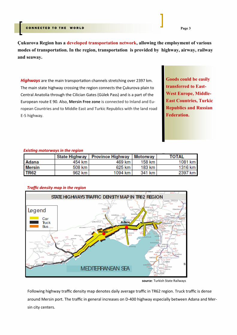
Following highway traffic density map denotes daily average traffic in TR62 region. Truck traffic is dense
around Mersin port. The traffic in general increases on D-400 highway especially between Adana and Mer-
sin city centers.
Page 3 C O N N E C T E D T O T H E W O R L D
Çukurova Region has a developed transportation network, allowing the employment of various
modes of transportation. In the region, transportation is provided by highway, airway, railway
and seaway.
Highways are the main transportation channels stretching over 2397 km.
The main state highway crossing the region connects the Çukurova plain to
Central Anatolia through the Cilician Gates (Gülek Pass) and is a part of the
European route E 90. Also, Mersin Free zone is connected to Inland and Eu-
ropean Countries and to Middle East and Turkic Republics with the land road
E-5 highway.
Goods could be easily
transferred to East-
West Europe, Middle-
East Countries, Turkic
Republics and Russian
Federation.
Traffic density map in the region
Existing motorways in the region
source: Turkish State Railways
Page 4
Airways
Adana International Airport went to service in 1937 as civil and military airport. After 1956, it began to use as
only civil airport which distance to the city centre is 3.5 km.
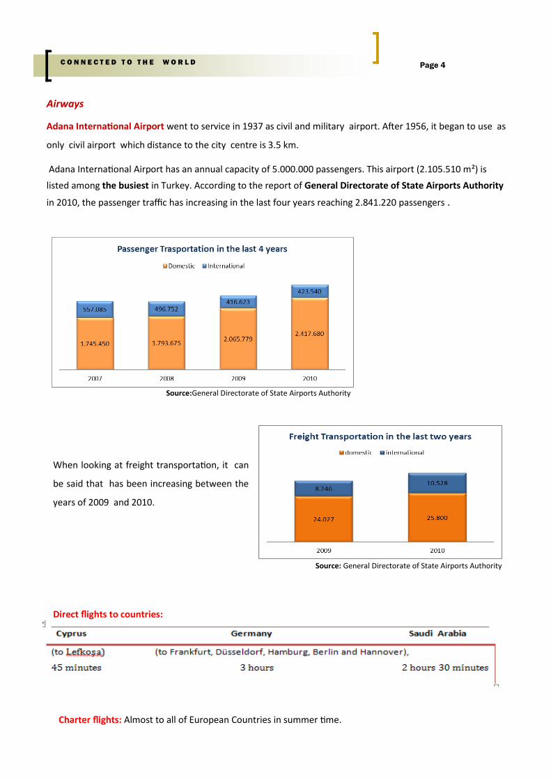
Adana International Airport has an annual capacity of 5.000.000 passengers. This airport (2.105.510 m²) is
listed among the busiest in Turkey. According to the report of General Directorate of State Airports Authority
in 2010, the passenger traffic has increasing in the last four years reaching 2.841.220 passengers .
Direct flights to countries:
C O N N E C T E D T O T H E W O R L D
When looking at freight transportation, it can
be said that has been increasing between the
years of 2009 and 2010.
Source:General Directorate of State Airports Authority
Source: General Directorate of State Airports Authority
Charter flights: Almost to all of European Countries in summer time.
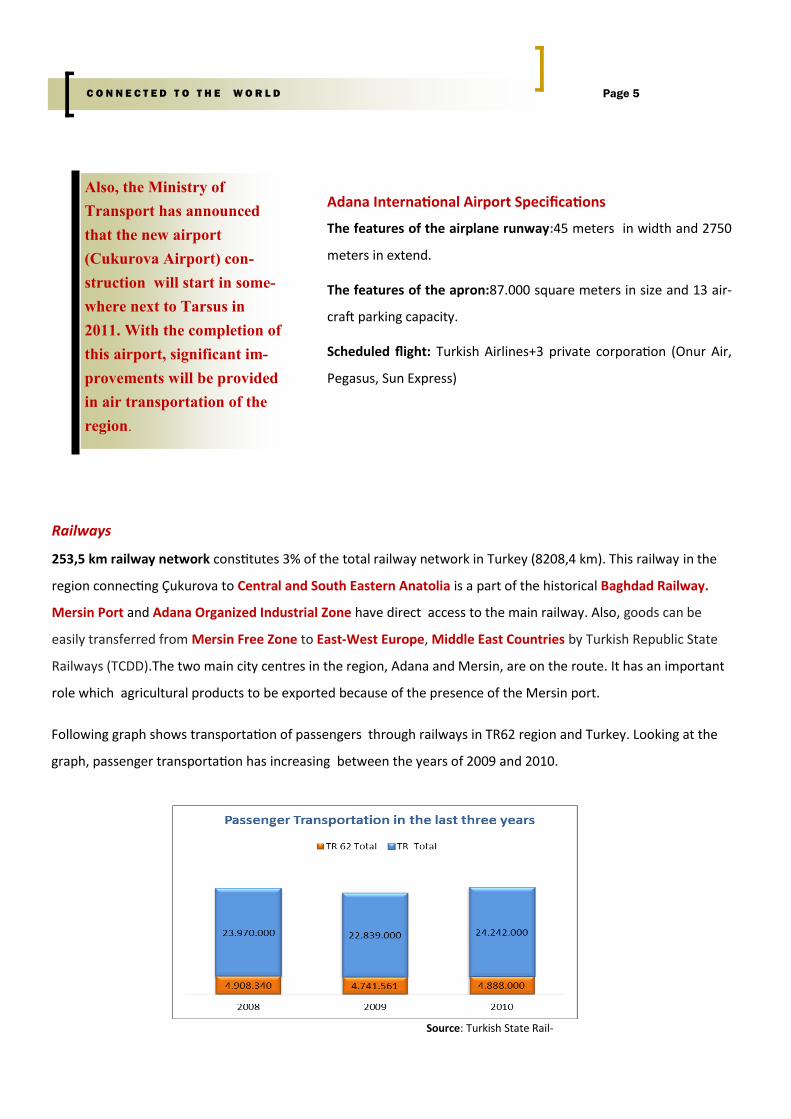
Following graph shows transportation of passengers through railways in TR62 region and Turkey. Looking at the
graph, passenger transportation has increasing between the years of 2009 and 2010.
Railways
253,5 km railway network constitutes 3% of the total railway network in Turkey (8208,4 km). This railway in the
region connecting Çukurova to Central and South Eastern Anatolia is a part of the historical Baghdad Railway.
Mersin Port and Adana Organized Industrial Zone have direct access to the main railway. Also, goods can be
easily transferred from Mersin Free Zone to East-West Europe, Middle East Countries by Turkish Republic State
Railways (TCDD).The two main city centres in the region, Adana and Mersin, are on the route. It has an important
role which agricultural products to be exported because of the presence of the Mersin port.
Page 5 C O N N E C T E D T O T H E W O R L D
Also, the Ministry of
Transport has announced
that the new airport
(Cukurova Airport) con-
struction will start in some-
where next to Tarsus in
2011. With the completion of
this airport, significant im-
provements will be provided
in air transportation of the
region.
Adana International Airport Specifications
The features of the airplane runway:45 meters in width and 2750
meters in extend.
The features of the apron:87.000 square meters in size and 13 air-
craft parking capacity.
Scheduled flight: Turkish Airlines+3 private corporation (Onur Air,
Pegasus, Sun Express)
Source: Turkish State Rail-
Page 6 C O N N E C T E D T O T H E W O R L D
Seaways
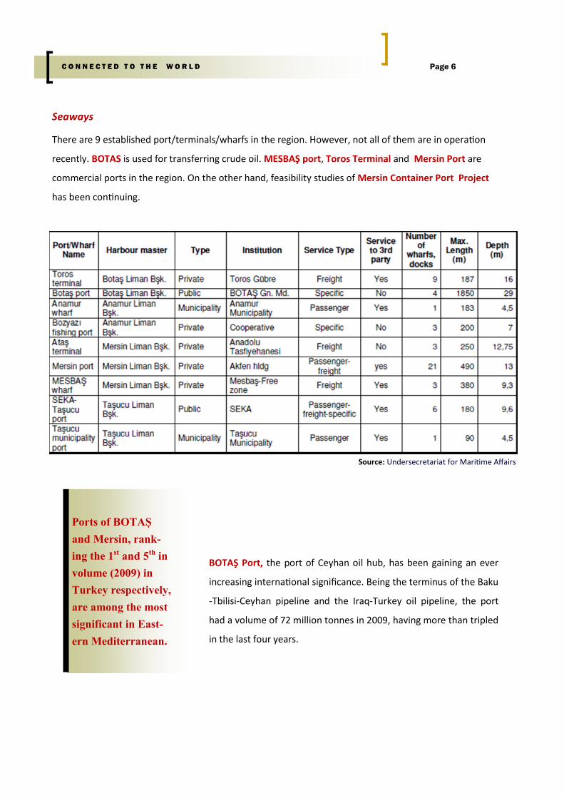
There are 9 established port/terminals/wharfs in the region. However, not all of them are in operation
recently. BOTAS is used for transferring crude oil. MESBAŞ port, Toros Terminal and Mersin Port are
commercial ports in the region. On the other hand, feasibility studies of Mersin Container Port Project
has been continuing.
Ports of BOTAŞ
and Mersin, rank-
ing the 1st and 5th in
volume (2009) in
Turkey respectively,
are among the most
significant in East-
ern Mediterranean.
Source: Undersecretariat for Maritime Affairs
BOTAŞ Port, the port of Ceyhan oil hub, has been gaining an ever
increasing international significance. Being the terminus of the Baku
-Tbilisi-Ceyhan pipeline and the Iraq-Turkey oil pipeline, the port
had a volume of 72 million tonnes in 2009, having more than tripled
in the last four years.
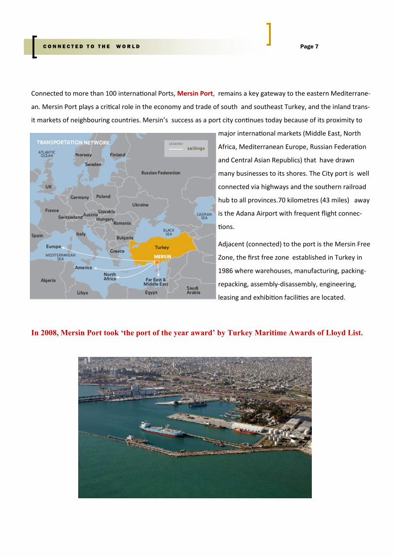
Connected to more than 100 international Ports, Mersin Port, remains a key gateway to the eastern Mediterrane-
an. Mersin Port plays a critical role in the economy and trade of south and southeast Turkey, and the inland trans-
it markets of neighbouring countries. Mersin’s success as a port city continues today because of its proximity to
major international markets (Middle East, North
Africa, Mediterranean Europe, Russian Federation
and Central Asian Republics) that have drawn
many businesses to its shores. The City port is well
connected via highways and the southern railroad
hub to all provinces.70 kilometres (43 miles) away
is the Adana Airport with frequent flight connec-
tions.
Adjacent (connected) to the port is the Mersin Free
Zone, the first free zone established in Turkey in
1986 where warehouses, manufacturing, packing-
repacking, assembly-disassembly, engineering,
leasing and exhibition facilities are located.
In 2008, Mersin Port took ‘the port of the year award’ by Turkey Maritime Awards of Lloyd List.
Page 7 C O N N E C T E D T O T H E W O R L D
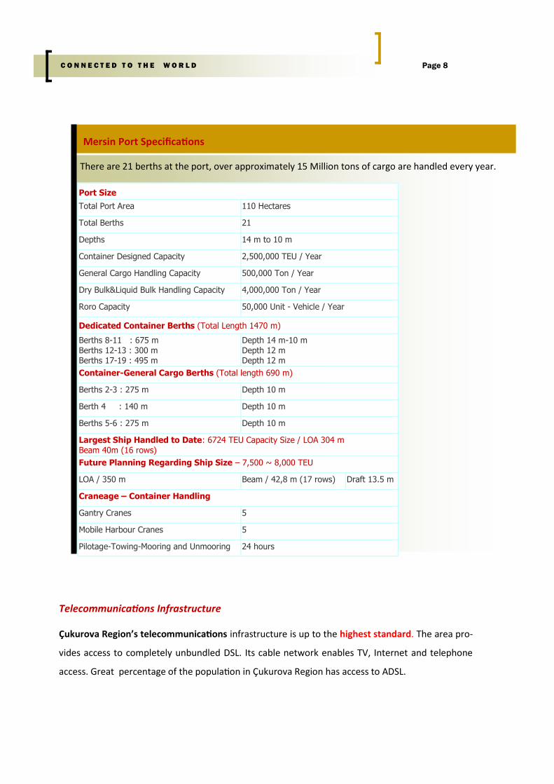
There are 21 berths at the port, over approximately 15 Million tons of cargo are handled every year.
Page 8 C O N N E C T E D T O T H E W O R L D
Mersin Port Specifications
Port Size
Total Port Area 110 Hectares
Total Berths 21
Depths 14 m to 10 m
Container Designed Capacity 2,500,000 TEU / Year
General Cargo Handling Capacity 500,000 Ton / Year
Dry Bulk&Liquid Bulk Handling Capacity 4,000,000 Ton / Year
Roro Capacity 50,000 Unit - Vehicle / Year
Dedicated Container Berths (Total Length 1470 m)
Berths 8-11 : 675 m Berths 12-13 : 300 m Berths 17-19 : 495 m
Depth 14 m-10 m Depth 12 m Depth 12 m
Container-General Cargo Berths (Total length 690 m)
Berths 2-3 : 275 m Depth 10 m
Berth 4 : 140 m Depth 10 m
Berths 5-6 : 275 m Depth 10 m
Largest Ship Handled to Date: 6724 TEU Capacity Size / LOA 304 m Beam 40m (16 rows)
Future Planning Regarding Ship Size – 7,500 ~ 8,000 TEU
LOA / 350 m Beam / 42,8 m (17 rows) Draft 13.5 m
Craneage – Container Handling
Gantry Cranes 5
Mobile Harbour Cranes 5
Pilotage-Towing-Mooring and Unmooring 24 hours
Telecommunications Infrastructure
Çukurova Region’s telecommunications infrastructure is up to the highest standard. The area pro-
vides access to completely unbundled DSL. Its cable network enables TV, Internet and telephone
access. Great percentage of the population in Çukurova Region has access to ADSL.


![The Companies Act, 1956 · The Companies Act, 1956 THE COMPANIES ACT, 1956 ACT NO. 1 OF 1956 [ 18th January, 1956] An Act to consolidate and amend the law relating to companies and](https://img.pdfslide.us/doc/110x75/5f6faf1fda141018fa3fcf35/the-companies-act-1956-the-companies-act-1956-the-companies-act-1956-act-no.jpg)