Embed Size (px)
Citation preview

Conflict for Resources: Water in the Lake Chad Basin
A Monograph
by MAJ Ethan L. Hall
USA
School of Advanced Military Studies United States Army Command and General Staff College
Fort Leavenworth, Kansas
AY 2009
Approved for Public Release; Distribution is Unlimited

REPORT DOCUMENTATION PAGE Form Approved
OMB No. 0704-0188 Public reporting burden for this collection of information is estimated to average 1 hour per response, including the time for reviewing instructions, searching existing data sources, gathering and maintaining the data needed, and completing and reviewing this collection of information. Send comments regarding this burden estimate or any other aspect of this collection of information, including suggestions for reducing this burden to Department of Defense, Washington Headquarters Services, Directorate for Information Operations and Reports (0704-0188), 1215 Jefferson Davis Highway, Suite 1204, Arlington, VA 22202-4302. Respondents should be aware that notwithstanding any other provision of law, no person shall be subject to any penalty for failing to comply with a collection of information if it does not display a currently valid OMB control number. PLEASE DO NOT RETURN YOUR FORM TO THE ABOVE ADDRESS. 1. REPORT DATE (DD-MM-YYYY)
11-05-2009 2. REPORT TYPE
SAMS Monograph3. DATES COVERED (From - To)
July 2008-May 20094. TITLE AND SUBTITLE Conflict for Resources: Water in the Lake Chad Basin
5a. CONTRACT NUMBER
5b. GRANT NUMBER
5c. PROGRAM ELEMENT NUMBER
6. AUTHOR(S) Major Ethan L. Hall, United States Army
5d. PROJECT NUMBER
5e. TASK NUMBER
5f. WORK UNIT NUMBER
7. PERFORMING ORGANIZATION NAME(S) AND ADDRESS(ES) School of Advanced Military Studies (SAMS)
8. PERFORMING ORGANIZATION REPORT NUMBER
250 Gibbon Avenue Fort Leavenworth, Kansas, 66027-2134
9. SPONSORING / MONITORING AGENCY NAME(S) AND ADDRESS(ES) 10. SPONSOR/MONITOR’S ACRONYM(S) 11. SPONSOR/MONITOR’S REPORT NUMBER(S) 12. DISTRIBUTION / AVAILABILITY STATEMENT Approved for Public Release; Distribution is Unlimited 13. SUPPLEMENTARY NOTES
14. ABSTRACT This monograph discusses the propensity for conflict surrounding the diminishing water in Lake Chad. The shortage of water in the lake and its basin threatens regional economic development and the existence of the population in the area. The paper uses a comparative case study to determine the extent that states conflict over scarce natural resources. The first case study examines the dispute over possession of the Spratly Islands located in the South China Sea. The Spratly Islands and the South China Sea may possess significant oil and natural gas deposits. The island chain is also claimed by multiple states with interstate conflict between China and Vietnam over legitimate possession.
The second case study examines the potential for conflict within the Lake Chad Basin. Lake Chad lies within four African states, Nigeria, Niger, Cameroon and Chad. These riparian states require water from the lake to support the population’s drinking, agriculture, livestock and sanitation. Since 1960, Lake Chad’s water has receded. Population increases, climate change, desertification, regional conflict and manmade water catchment projects compound the regional shortage of water.
15. SUBJECT TERMS Water Security, Lake Chad, Lake Chad Basin, Spartly Islands, Nigeria, Niger, Cameroon, Chad, USAFRICOM
16. SECURITY CLASSIFICATION OF:
17. LIMITATION OF ABSTRACT
18. NUMBER OF PAGES
19a. NAME OF RESPONSIBLE PERSONStefan J. Banach, US Army
a. REPORT (U)
b. ABSTRACT (U)
c. THIS PAGE(U)
(U) 48
19b. TELEPHONE NUMBER (include area code)
(913) 758-3302 Standard Form 298 (Re . 8-98)v
Prescribed by ANSI Std. Z39.18
SCHOOL OF ADVANCED MILITARY STUDIES
MONOGRAPH APPROVAL
MAJ Ethan L. Hall
Title of Monograph: Conflict for Resources: Water in the Lake Chad Basin
Approved by:
__________________________________ Monograph Director Daniel G. Cox, PhD.
__________________________________ Monograph Reader Michael Lee, COL, USMC
___________________________________ Director, Stefan Banach, COL, IN School of Advanced Military Studies
___________________________________ Director, Robert F. Baumann, Ph.D. Graduate Degree Programs
ii
iii
Abstract Conflict for Resources: Water in the Lake Chad Basin by MAJ Ethan L. Hall, USA 45 pages.
This monograph discusses the propensity for conflict surrounding the diminishing water in Lake Chad. The shortage of water in the lake and its basin threatens regional economic development and the existence of the population in the area. The paper uses a comparative case study to determine the extent that states conflict over scarce natural resources. The first case study examines the dispute over possession of the Spratly Islands located in the South China Sea. The Spratly Islands and the South China Sea may possess significant oil and natural gas deposits. The island chain is also claimed by multiple states with interstate conflict between China and Vietnam over legitimate possession.
The second case study examines the potential for conflict within the Lake Chad Basin. Lake Chad lies within four African states, Nigeria, Niger, Cameroon and Chad. These riparian states require water from the lake to support the population’s drinking, agriculture, livestock and sanitation. Since 1960, Lake Chad’s water has receded. Population increases, climate change, desertification, regional conflict and manmade water catchment projects compound the regional shortage of water.

Table of Contents
Section 1: Introduction ..................................................................................................................... 1 Method ...................................................................................................................................................... 2 Literature Review ...................................................................................................................................... 3
Section 2: Spratly Islands Case Study .............................................................................................. 5 Spratly Archipelago .................................................................................................................................. 6 United Nations Convention Law of the Sea .............................................................................................. 7 Spratly Claims ........................................................................................................................................... 9 Conflict over the Islands ......................................................................................................................... 14 Analysis of Claims .................................................................................................................................. 16
Section 3: Lake Chad System ........................................................................................................ 18 Water in General ..................................................................................................................................... 19 Climate Change ....................................................................................................................................... 21 International Law and Cooperative Organizations ................................................................................. 22 Lake Chad ............................................................................................................................................... 25 Tributaries ............................................................................................................................................... 27
Chari-Logone River Sub-system ......................................................................................................... 27 Komadugu-Yobe River Sub-system ................................................................................................... 29
Lake Chad Basin Demographics ............................................................................................................. 31 Previous Conflict Surrounding Lake Chad ............................................................................................. 34 Future Concerns for the Lake Chad Basin .............................................................................................. 36 The Propensity of the Lake Chad System ............................................................................................... 38 Refugees Implications for USAFRICOM ............................................................................................... 40
Section 4: Conclusion .................................................................................................................... 43 Bibliography .................................................................................................................................. 45
Index of Tables and Figures Table 1: Falkenmark Water Stress Index .................................................................................................... 20 Table 2: Water Per Capita .......................................................................................................................... 21 Table 3: Riparian State Demographics ....................................................................................................... 32 Figure 1: Map of Spratly Islands and Surrounding Area .............................................................................. 7 Figure 2: Lake Chad Basin ......................................................................................................................... 19 Figure 3: The Lake Chad System ................................................................................................................ 38
iv

Section 1: Introduction
Throughout human history, conflict over disputed resources has been a justification for interstate
conflict. This monograph examines conflict over water resources. The 2008 Joint Operating Environment,
which forecasts out to the year 2030, predicts water scarcity could affect 3 billion people.1 The report
further asserts conflict is likely to arise where water scarcity converges with other environmental and
societal tensions. Fortunately for human society, interstate water wars are rare. The last true water war
occurred over 4,500 years ago in ancient Mesopotamia. While wars fought over water are rare, water
rights are usually an issue during peace settlements.2 It is logical to assume as water becomes scarcer, the
conflict surrounding water resources also increases.
This paper examines two case studies. The first case study is the dispute over the Spratly Islands.
The chapter examines the physical characteristics of the island chain, international law governing
territorial waters, the states’ claims to the islands and military conflict surrounding the islands. The
Spratly Islands case study establishes a precedent for interstate conflict over natural resources,
specifically oil and natural gas deposits.
The second case study examines Lake Chad located in western Africa. The lake shares a border
with four states, Nigeria, Niger, Cameroon, and Chad. This portion of the monograph establishes the
scarcity of freshwater worldwide and the water environment in the four countries and throughout the Lake
Chad basin. The chapter also reviews international laws governing transboundary watercourses, Lake
Chad and its tributaries, the population demographics affecting the basin, previous conflicts surrounding
the lake and future issues affecting the lake. Lastly, the chapter examines the propensity of conflict
surrounding the Lake Chad system if left unchecked.
The author’s systemic approach requires some explanation. The Spratly Islands and Lake Chad
dispute are complex systems with interwoven relationships. The subsections of the chapters are
1 United States Joint Forces Command, The Joint Operating Environment 2008: Challenges and
Implications for the Future Joint Force (Suffolk: Virginia: 2008), 20. 2 The 1967 Israeli War settled with Israel gaining control of the majority of the water in the Jordon River.
1

components of that system. Concluding each chapter is the propensity of the system using the
relationships of the assemblages.
Method
This monograph uses a comparative case study method to determine the propensity for conflict
arising from access to scarce natural resources. The first case study will examine the Spratly Islands and
the ongoing conflict in the South China Sea for access to potential oil reservoirs. The Spratly Islands case
is a useful example of states engaging in conflict in order to secure natural resources they believe are vital
to their national security or economic progress. When the demand for resources increases and when
existing resources accessibility to a state do not meet anticipated demand, the expectation is that friction
between states vying for the same scarce resource can escalate into violent conflict.
The second case study involves access to fresh water in Lake Chad. Like the Spratly Islands with
multiple claims of ownership, Lake Chad is located at the border of four African states, Nigeria, Niger,
Chad and Cameroon. Historically, the lake’s size increases and decreases with the season’s rains and the
feeding tributaries. However, due to low seasonal rainfalls and diverting of tributaries, the current size of
the lake is smaller than historical norms. The decrease of water in the lake and its tributary systems has
caused a shortage of a resource for all people relying on the lake for drinking water, livestock, agriculture
and fishing. The author is particularly interested in comparing cases, where multiple nations are
competing for scarce natural resources and where ambiguity exists over which state or states legitimately
controls or has a valid claim over these resources. The competition for oil in the Spratly Islands has
already led to military friction between the states laying claim to the island region. The Lake Chad shares
many similarities and one could argue that water is even a greater vital commodity than oil to any state.
Given this, the author proposes to test the following hypotheses:
H1 : Water depletion of Lake Chad will cause a humanitarian crisis and interstate conflict over
scarce resources developing into a security concern for USAFRICOM.
2

H0: Water depletion of Lake Chad will not cause a humanitarian crisis and interstate conflict over
scarce resources developing into a security concern for USAFRICOM.
While the hypothesis states conflict over the water will cause interstate friction and possible
conflict, history has not supported this argument. If H0 proves to be true, what factors cause the level of
friction not to rise to the level of inter-state conflict? Furthermore, are the factors exportable to claims
over other natural resources?
Literature Review
The reasons for conflict over water are not evident because water wars have not occurred in 4,500
years. History has shown most conflicts involving water are resolved through local cooperation efforts or
larger state to state grievances incorporating water issues into peace settlements. However, there are some
ideas that explain why states wage wars and how scarce natural resources influence the states.
Carl von Clausewitz’s treatise, On War serves as a starting point for any discussion about war. He
claims states conduct war to achieve a political end.3 His trinity of danger, reason and chance, guides
state’s foreign policy regarding the appropriate use of force. If all state actions, including war, are
political in nature, foreign policy must be the visible manifestation of how states interact with other states
to get what they want. Paul Collier and Nicholas Sambanis while working as chief economists for the
World Bank developed another useful model. Their model examines the variables influencing African
nations’ stability, specifically whether a state is prone to civil war. Collier and Sambanis use quantifiable
methods such as the opportunity model and grievance models as predictors of stability.4 B.C. Smith,
Professor of Politics at the University of Dundee, also developed theories predicting conflict. Smith
3 Carl Von Clausewitz, On War, (New Jersey: Princeton University Press, 1976), 87. 4 Paul Collier and Nicholas Sambanis, Understanding Civil War Volume 1: Africa (Washington DC: The
World Bank: 2005)3-17.
3

focused on the qualitative aspects of a country’s political system and determines if the political regime is
stable.5 These themes provide the foundations for understanding conflict over scarce resources.
Clausewitz, Collier and Smith’s theories provide and understanding about why countries wage
war, and conflict over access to natural resources. If states wage wars for political reasons based on their
fear, honor or interests, then accepting that states engage in conflict to secure resources vital to their
interests is a logical conclusion. Michael Klare, author of Resource Wars, argues nations will interpret
any interference of resources, particularly natural resources, as threatening a state’s national security.6
Greg Austin furthers the argument in China’s Ocean Frontier by adding the sovereignty of the nation to
the problem. He acknowledges the need to ensure a state’s security by access to scarce resources;
historical claims to the resources drives states to conflict. Without this claim to sovereignty, states work
through cooperation agreements to secure access to resources.7 In addition to historical claims,
international norms are fundamental to the decision of who is sovereign over shared natural resources. At
the heart of Austin’s argument are the norms of territorial acquisition. He discusses four concepts,
occupation, prescription, cessation and conquest, and accretion.8 Marwyn Samuels includes historical
claims into the validity of resource claims. According to Samuels, Chinese maritime law supports China’s
claim to the Spratly and Paracel islands.9
What is the link between environmental scarcities and inter/intra state conflict? Thomas Homer-
Dixon, a professor at the University of Waterloo, theorizes there is a causal link between damaged
environments and conflict. He hypothesizes three environmental links with violent conflict. First,
decreasing supplies of controllable resources provokes interstate resource wars. Second, large population
5 B.C. Smith, “Understanding Third World Politics (Bloomington: Indiana University Press, 2003), 219. 6 Michael T. Klare, Resource Wars, (New York: Metropolitan Books, 2001), 23. 7 Greg Austin, China’s Ocean Frontier: International Law, Military Force and National Development,(St.
Leonards: Allen & Unwin, 1998), 13. 8 Austin, 339-350. 9 Marwyn S. Samuels, Contest for the South China Sea (New York, New York: Methuen) 77.
4

movements caused by environmental factors produces ethnic clashes. Finally, environmental scarcity
causes economic deprivation and disrupts social institutions leading to civil strife and insurgencies.10
Water is the most precious natural resource. While the Earth has lots of water, very little of it is
freshwater. Miriam Lowi, author of Water and Power describes political dynamics of high and low
politics. High politics are the state to state level negotiations and low politics are intrastate negotiations at
local levels. She claims low politics negotiate water disputes.11 Her studies of the Jordan River Valley
have shown that arrangements at the local levels resolve conflicts over water. A useful indicator of water
stress in a region is the Falkenmark Water Stress Index which relates scarcity with the meters of water
available per person.12 This metric is heuristic and does not account for agriculture, livestock or unequal
distribution. Aaron Wolf, Professor of Geology at Oregon State University, recognizes the difficulty and
potential for conflict for water claimed by multiple states. He built on the Falkenmark model and added
two additional considerations. First, determine the supply and demand aspects of the water source.
Second, determine if the region’s political infrastructure and economic base can absorb the stress from the
water situation. If the institution absorbs the stress, water cooperation policies reduce the potential for
violence. However, if the institution cannot absorb the additional stress, water conflict is the predicted
outcome.13 He argues strong international cooperation is the diffusing mechanism for these riparian
conflicts.
Section 2: Spratly Islands Case Study
The Spratly Islands region provides an ideal barometer for observing the conditions in which
states compete for natural resources. This section defines the physical geography of the region, the claims,
applicable laws, and a history of the conflict. The Spratly Islands themselves do not provide any strategic
10 Thomas Homer-Dixon, “Environmental Scarcities and Violent Conflict: Evidence from Cases”,
International Security 19 (1994), http://www.library.utoronto.ca/pcs/evidence (accessed 10 February 2009). 11 Miriam Lowi, Water and Power (Cambridge, UK: Cambridge University Press), 9. 12 Aaron T. Wolf, Shira B Yoffe, and Mark Giordano “International Waters: Identifying basins at risk”,
Water Policy 5 (2003), 41. 13 Aaron T. Wolf, “Water Conflict and Cooperation”, State of the World 2005 (2005), 90.
5

advantage to any nation. However, if any state successfully claims the Spratly Islands, the state also
claims the 12 mile territorial waters and the 200 mile Exclusive Economic Zone (EEZ) which includes
fishing and any natural gas or oil under the seabed. This section demonstrates states resort to conflict to
secure these rights.
Spratly Archipelago
The Spratly Islands are located in the South China Sea between China, Taiwan, the Philippines,
Vietnam and Indonesia. There are three categories within the Spratly Islands, Western, Southern Shoals
and the Dangerous Area.14 Figure 1 shows the dispersion of islands in the archipelago and it’s
proximately to neighboring countries in the South China Sea. In total, there are 235 barren rocks making
up the Spratly archipelago, many of which are not above sea level during high tide.15 The largest of the
islands are Spratly Island at 750 meters long and 450 meters wide, the Northeast Cay at 1 kilometer long
and 400 meters wide and Itu Abu at 1 kilometer long and 400 meters wide.16 The archipelago, with a total
land mass of 3 square kilometers, sprawls over 200,000 square kilometers.17 None of the Spratly Islands
have any indigenous populations and only a handful have any people. Since these islands cannot support
life, all life sustaining supplies need to be brought to the islands. In order to understand the history of the
claims for sovereignty by multiple nations, it is important to understand why the nations are seeking
sovereignty. The following sections discuss the United Nations Convention Law of the Sea and the
potential natural resources of the archipelago.
14 Bob Catley, Spratlys: The Dispute in the South China Sea (Aldershot: Ashgate Publishing Limited), 3. 15 Ibid. 16 Greg Austin, China’s Ocean Frontier: International Law, Military Force and National Development (St
Leonards: Allen and Unwin Australia Party Ltd), 132. 17 John C. Baker, Cooperative Monitoring in the South China Sea (Westport: Praeger), 2.
6

Figure 1: Map of Spratly Islands and Surrounding Area18
United Nations Convention Law of the Sea
The United Nations Convention Law of the Sea (UNCLOS) passed in 1982, establishes some
important terms of reference for the parties claiming sovereignty over the Spratly Islands. The convention
defines states’ territorial waters as extending up to 12 nautical miles. Inside the territorial waters, a state
has sovereignty over the air, surface, sub-surface and sub-soil.19 The convention also describes a state’s
Exclusive Economic Zone (EEZ). Article 57 defines the EEZ as, “The exclusive economic zone shall not
extend beyond 200 nautical miles from the baselines from which the breadth of the territorial sea is
measured.”20 The EEZ gives the state sovereign rights to explore and exploit the natural resources on
18 Spratly, Spratly Islands (Nansha Islands) of China, http://www.spratlys.org/maps/1/spratly-
islands_95.jpg (accesses 15 January 2009). 19 Oceans and the Law of the Sea, “United Nations Convention on the Law of the Sea”,
http://www.un.org/Depts/los/convention_agreements/texts/unclos/closindx.htm (accessed 3 January, 2009). 20 Ibid.
7

land, below the water and sub-soil. Lastly, the UNCLOS states in Article 121, rocks that cannot sustain
human occupation cannot possess EEZ or a continental shelf.21 The UNCLOS establishes the parameters
for a state to lay claim to a region of water and exploit the resources within the water.
The South China Sea, in which the Spratly Archipelago resides, may have substantial deposits of
oil and natural gas. Oil was discovered in the region as early as the 19th century with the first oil well
drilled in 1872.22 The sovereignty disputes of the Spratly region prevent any exploratory drilling, but
estimates of the oil reserves are over 7 billion barrels.23 However, Chinese estimates of the oil reserves
are much higher. They estimate the potential oil reserves as high at 213 billion barrels of oil. Outside of
China this claim is largely disputed.24 Despite this, the Chinese estimate would place the South China Sea
as the second largest oil reserve next to the Persian Gulf.
Oil is not the only natural resource drawing states into confrontation over the Spratly Islands. The
South China Sea also has known natural gas deposits. The US Geological Survey has the South China Sea
estimates for natural gas at 266 Trillion Cubic Feet (Tcf) and the Spratly Islands at 35 Tcf.25 The Chinese
estimates, like their estimates for potential oil reserves, are higher. The Chinese estimate the potential
natural gas reserves at 900 Tcf for the Spratly’s and 2,000 Tcf for the South China Sea.26 The demand for
energy is increasing throughout Asia, in particular China, and throughout the world. The competition for
access to energy resources in the Spratly Islands remains a source of tension for the region.
21 Ibid. 22 Samuels, 154. 23 Baker, 40. 24 Ibid 41. The US Geological Survey claims the potential oil reserves may be 23 bil b/d for the South
China Sea, including the Paracel and Spratly Islands. This figure still places the South China Sea as the world’s third largest oil reserve.
25 Ibid, 43. 26 Ibid, 42-43.
8
Spratly Claims
The People’s Republic of China (PRC) lays claim to the entire Spratly archipelago through the
principle of first discovery. China claims Chinese fishermen discovered the Spratly Islands in the 2nd
Century and mapped the archipelago by the 3rd Century.27 While China may have discovered the Spratly
Islands, they did not administer over the islands. The first modern claim to the Spratly Islands occurs in
1933. The French annexed seven of the islands on 26 July 1933 under the terra nullius, land belonging to
no one.28 The Chinese protested France’s claim over the islands. China responded with the right of first
discovery and asserted Chinese nationals worked and lived on the islands. The next critical date for
Chinese claim to the Spratly Islands is 1946. Despite China’s protest of French annexation, the islands
remained under control of French forces from 1933-1939. In 1939, Japanese forces occupied islands in
the Spratly archipelago and claimed the entire island chain as Japanese territory. After Japan’s defeat in
WWII, possession of these islands reverted back to France. In 1946, both the French and Chinese sent
naval forces to the Spratly Islands to take possession of the islands.29 French forces landed on Spratly and
Itu Aba islands and left stone markers linking the landings to the 1933 annexation.30 While it is clear a
Chinese naval force went to Itu Abu, it is not clear if they took possession of the island by occupation.
However, one year later, the Republic of China placed the Spratly Islands under the administrative control
of the Kuangtung Province and a Chinese administrator occupied his position on Itu Aba Island.31
The 1951 Treaty of San Francisco intended to wrap up the Japanese involvement during WWII in
the Pacific. However, since the end of the World War II to the beginning of the conference, the players
had changed. The Chinese Civil War created the People’s Republic of China (PRC) on the mainland and
the Republic of China (ROC) on Formosa Island. Both of the Chinas, with identical claims to all of the
27 Catley, 33. 28 Austin, 135. 29 Ibid, 141. 30 Austin, 142. 31 Samuels, 76.
9

Spratly Archipelago, were absent from the conference.32 At this conference, Japan officially renounced all
claims to the Paracel and Spratly Islands. Absent from the declaration is acknowledgement to whom the
islands belong. International tribunals have subsequently judged the Japanese occupation of the islands to
be illegal and therefore sovereignty remained with France.33 Using the Soviet Union delegation as a
proxy, the PRC formally declared the entire Spratly archipelago as sovereign Chinese territory.34 In
August of 1951, the Foreign Minister for the PRC declared the Spratly Islands have always been Chinese
territory, and they remain Chinese territory regardless of any treaties.35 Currently, China occupies seven
of the larger islands.36
Taiwan’s claim to the Spratly Islands mirrors China’s, they claim the entire Spratly chain as
sovereign territory based on first discovery. Taiwan is in a much different strategic position than China.
The desire for the natural resources is not the motivating factor in Taiwan’s desire for the Spratlys. A
Taiwanese claim to the Spratly Islands allows them to maintain the Sea Lines of Communication open
and prevent a naval blockade from China.37 Taiwan possesses one island in the Spratlys, Itu Aba. China
occupied this island in 1947, but withdrew its forces after the emergence of the Peoples Republic of
China. However, Taiwan reoccupied the island in 1956 and maintains a small garrison, approximately
100 soldiers, to the present day.38
The Socialist Republic of Vietnam (SRV) also claims the entire Spratly Archipelago as sovereign
Vietnamese territory. Three events supported the Vietnamese claims to the Spratly Islands, historical
claims going back to the 17th century, the French claims of 1933/1946 and the Vietnamese government’s
actions after 1951. Vietnamese published history with the Spratly Islands goes back to the 1630s with
32 Ibid, 78. 33 Austin, 144. 34 Samuels, 78. 35 Ibid, 79. 36 Baker, 4. 37 Catley, 85. 38 Rames Amer, War or Peace in the South China Sea?(Copenhagen: NIAS, 2002), 30.
10

atlases mentioning the island chain.39 Vietnamese history shows evidence of the South China Sea
exploited for economical benefit as evident by Vietnamese salvage parties recovering cargo from
shipwrecks. Furthermore, Vietnamese fishermen harvested fish and turtles from the surrounding seas.40
European mariners trading with Asian cultures recognized the Vietnamese claims. Specifically, Dutch and
Portuguese maps indicate the Spratly islands under Vietnamese control.41 The economic importance of
the Spratly Islands facilitates Vietnamese administrative control of the archipelago under the Binh Son
district.42 However, at the time, the Spratly Islands were lumped together with the Paracel Islands.
Despite this fact, Vietnamese history documents discovery, economic exploitation and administration of
the islands.
As discussed earlier, the French claimed seven of the Spratly Islands. Vietnam claims the French
titles to the Spratly Islands transferred to Vietnam, specifically to the Republic of Vietnam when they
gained independence in 1954. French claims to the islands date back to the 1933 annexation. France
claimed these islands for the state of Vietnam (Cochin China). At the time of annexation, Cochin China
was the sovereign territory of France and was serving as a protectorate for the states of Tonkin, Laos,
Annam and Cambodia. 43 When France granted independence to the Republic of Vietnam in 1954, they
also granted Vietnam sovereignty of the Paracel Islands. France never transferred title of the Spratly
Islands to the new Vietnamese state.44 In 1956, the Charge d’ Affaires in Manila informed the Philippine
government the Spratly Islands were French territory.45
39 Todd C. Kelly, “Vietnamese Claims to the Truong Sa Archipelago (ed. Spratly Islands), A Journal of
Southeast Asian Studies Student Association. http://www.hawaii.edu/cseas/pubs/explore/todd.html (accessed 6 January 2009).
40 Ibid. 41 Ibid. 42 Ibid. 43 Austin, 140. 44 Samuels, 77. 45 Ibid, 84.
11

Vietnam formally announced its sovereignty over the Spratly Islands during the San Francisco
Conference in 1951. The Vietnamese delegation asserted for the first time that the Spratly Islands were
the territory of Vietnam and had always belonged to Vietnam.46 The chain of title for Vietnam becomes
muddy with the division of Vietnam to separate states, the Democratic Republic of Vietnam (DRV) and
the Republic of Vietnam (RVN). The RVN maintained its rights to the Spratly Islands, but the DRV
recognized the PRC’s claim to the islands.47 The RVN occupied several of the islands from 1973-1975.48
The RVN consistently protested any other states claim to the Spratly Islands, including China, Malaysia
and Vietnam. When Vietnam reunified in 1976, the DRV reiterated its claim to the Spratly Islands. By the
1980s, Vietnam started to occupy islands in the Spratlys. Currently, Vietnam occupies 27 islands and
maintains 600 soldiers in the Spratly Islands.49 As of May, 2008, Vietnam continues to contend
sovereignty over the Spratly archipelago.50
Malaysia currently claims the southern part of the Spratly archipelago. Malaysia publicized its
claim to the Spratly Islands with a map depicting the 12 mile territorial waters and its continental shelf in
December 1979.51 Malaysia’s claim to the islands is based on terra nullius.52 Malaysia argues the
unoccupied islands in their map fall within Malaysia’s continental shelf.53 This claim of terra nullius for
all of the claimed islands is not supportable because Vietnam occupied two of the islands, Amboyna Cay
and Barque Canada. In 1983, Malaysia occupied its first islands in the archipelago, Swallow Reef. The
PRC and Vietnam formally objected to Malaysia’s occupation of their islands claiming the island’s
46 Kelly. 47 Austin, 149. 48 Ibid, 146. 49 Baker, 4. 50 BBC Monitoring Asia, “Vietnam reaffirms sovereignty over Spratly, Paracel Islands”,6 May, 2008,
http:// www.proquest.com (accessed 8 January, 2009). 51 Nguyen Hong Thao, Ramers Amer, “Managing Vietnam’s Maritime Boundary Disputes, Ocean
Development and International Law 38 (2007): 308. 52 Terra Nullius is a legal term meaning land belonging to no one. 53 Austin, 156.
12

sovereignty was already established.54 Malaysia expanded its occupations and currently occupies four
islands with approximately 70 soldiers.55
The Philippine claim to the Spratly islands goes back to 1956. On 11 May 1956, a Filipino named
Thomas Cloma claimed 33 islands in the southern Spratlys for the independent state of Kalayaan or
Freedomland.56 Cloma intended to establish a state, distinct from the Philippines. He claimed the right of
discovery and his group’s occupation of the islands gave them the legal authority to take possession of the
islands. Vietnam and the Republic of China immediately protested the Cloma’s claims and sent warships
to ensure their sovereign rights.57
The official Philippine response to Cloma’s claim is a major impetus to the current debate over
the islands. The Philippine Vice-President’s response to Cloma’s claim indicated the Spratly Islands,
since abdicated by the Japanese through the San Francisco Treaty with no successor specified, were the
possessions of the Allied Powers.58 His response did not assert Filipino claims on the islands, but rather
res nullius.59 This response, combined with Cloma’s declaration of possession, triggered the ROC to re-
occupy Ita Abu and prompted naval patrols by the ROC, Vietnam and the PRC.60 Thomas Cloma’s claim
to the Spratly Islands served as the core of Philippine claims to the islands.
In 1971, the Philippine government began asserting its rights to the Spratly Islands. On 10 July
1971, the Philippine President, Marcos, laid claim to 53 islands within the Spratly archipelago based on
the Cloma claims in 1956.61 Shortly after President Marcos proclamation, the Philippine Navy occupied
54 Austin, 156. 55 Baker, 4. 56 Samuels, 82. 57 Austin, 152. 58 Samuels, 83. 59 Res nullius is a legal term meaning the property belongs to everyone. For example, wildlife belongs to
everyone and not a specific person. In the case of the Spratly Islands, the archipelago belongs to all of the allied powers of WWII and is a shared asset for everyone’s benefit.
60 Samuels, 86. 61 Ibid, 89.
13
four of the southern Spratly reefs and islands.62 By April, 1972, the Philippine province of Palawan
administered Cloma’s Kalayaan state. The Philippine government asserts Thomas Cloma passed his claim
of the Spratlys to the Philippines. In 1978, the Philippines issued Presidential Decree 1596 claiming
sovereignty over the Spratly Islands.63 The decree claimed Philippine sovereignty supported by four
points. The islands belonged to no state, and since the Philippines now occupy the area they are under
Filipino jurisdiction. Previous claims to the islands by other states are no longer supported because of
abandonment. Kayalaan is on the Philippine continental shelf. Finally, the proximity of the islands is vital
to the Philippines security and economy.64 The Philippines currently occupies eight islands and has
approximately 480 soldiers stationed there.65
Conflict over the Islands
Each of the above states lay claim to all or some of the Spratly Islands. There is an increased risk
of conflict because of the garrisons on the islands, the diplomatic rhetoric, the potential for natural
resources and a history of conflict. This section discusses the conflict arising from the Spratly Islands.
The first instance of conflict, and the most violent, occurred in 1988 between China and Vietnam. The
PRC started in earnest occupying islands throughout out the Spratlys. In March 1988, China occupied
Fiery Cross Reef with its soldiers. The PRC, while already claiming sovereignty over the entire
archipelago, reinforced their claim with military occupations. Vietnam, also claiming the entire
archipelago, protested China’s occupation of its sovereign island by sending a naval fleet to the reef.
China sunk three Vietnamese ships and killed 74 Vietnamese sailors during the brief naval clash.66 Since
the naval clash in 1988, China has detained fishermen from countries with competing claims for
62 Austin, 153. 63 Chan Robles Virtual Law Library, “Presidential Law Decree 1596”,
http://www.chanrobles.com/presidentialdecrees/presidentialdecreeno1596.html (accessed 13 January 2009) 64 Austin, 154. 65 Baker, 4. 66 Catley, 8
14

exploiting resources in China’s EEZ. Taiwan claims 134 fishing boats were detained, harassed or fired
upon by China’s naval forces from 1992-1996.67 China, while certainly the military power in the region,
is not the only antagonist. In 1998, the Philippine Navy detained and later arrested 20 Chinese fishermen
at Mischief Reef.68 The PRC, ROC, Vietnam and the Philippines claim Mischief Reef. In October 1999,
Vietnamese forces on Tennent Reef fired on a Philippine aircraft while it was conducting an over flight at
200ft.69 The United States is not immune to the conflicts in the Spratly Islands. The April 2001, midair
collision of a US Navy EP-3 and a Chinese F-8 fighter resulted in the death of the Chinese pilot and the
American crew detained on Hainan Island.70 To strengthen claims of sovereignty, states occupied more
islands. Since all of the islands are claimed by China, Vietnam and Taiwan and select islands by the
Philippines and Malaysia, any additional claims of disputed islands are sternly rebuked. The reactions are
predominately diplomatic, but with military garrisons in the region, aggression remains an option.
International organizations attempt to mitigate the potential for conflict over the Spratly Islands.
International organizations have taken measures to reduce the levels of conflict in the South
China Sea. Association of South East Asian Nations (ASEAN) produced two documents, the Treaty of
Amity and Cooperation and the Declaration on the Conduct of Parties in the South China Seas, to enable
peaceful conflict resolution. ASEAN’s Treaty of Amity and Cooperation (TAC) is a document designed
to foster mutual cooperation and peaceful resolution of disputes within the ASEAN countries. Chapter 4,
Pacific Settlement Disputes, states, “In case disputes on matters directly affecting them should arise,
especially disputed likely to disturb regional peace and harmony, they shall refrain from the threat or use
of force and shall at all times settle such disputes among themselves through friendly negotiations.”71
Two of the Spratly claimants, Malaysia and the Philippines, signed the 1976 treaty. Vietnam signed the
67 Baker, 51. 68 “Beijing Presses Manila to Free 20 Fishermen” New York Times, 22 December, 1998, A4. 69 Baker, 60. 70 Ibid, 51. The crew of the American EP-3 was later released. 71 ASEAN, “Treaty of Amity and Cooperation in South East Asian Indonesia, 24 February 1976”,
http://www.aseansec.org/1217.htm (accessed 17 January 2009).
15

treaty in 1998 and the PRC agreed to accede to the provisions of the treaty in 2003.72 Only Taiwan does
not expressly adhere to the treaty, however, ASEAN recognizes a one China policy. The other document
attempting to ameliorate Spratly claimants is the Declaration on the Conduct of Parties in the South China
Sea.
ASEAN’s Declaration of the Conduct of Parties in the South China Sea intended to reduce the
incidents and potential for violent conflict over the Paracel and Spratly Islands. In the declaration, the
signatories commit themselves to the UNCLOS principles of freedom of navigation and overflight in the
South China Sea. Further, the treaty prohibits states from the use of force or the threat of force to resolve
territorial disputes, to include military occupation of uninhabited islands.73 The PRC and Malaysia signed
the declaration in 2002; however, Vietnam, the Philippines, and Taiwan did not sign the declaration.
Analysis of Claims
The status quo in South China Sea appears to be tolerable to all claimants as evident by the lack
of military conflict and legal actions submitted through the international courts. The UNCLOS, as written,
supports each of the claimants’ legal justification to the archipelago. The semi-enclosed South China Sea
ensures all parties’ claims lie within their EEZ or within their continental shelf. The PRC’s claim to the
Spratlys is the weakest according to international law because they have no continental shelf and the
Spratlys physical proximately from the Chinese mainland. Mainland China is over 1000 miles from the
nearest island in the Spratlys. The claim of right of discovery does not imply the islands’ occupation and
exploitation. The claims’ strength is irrelevant because the PRC continues its claim over the entire
archipelago and occupies seven islands with no competing state capable of forcefully asserting their
claims of sovereignty. Being the regional hegemon allows the PRC to sign regional treaties and
declarations concerning the Spratlys yet not be constrained by the documents as evident by expanding
72 Embassy of the Peoples Republic of China in the Republic of Indonesia, “China joins treaty of Amity,
Cooperation in Southeast Asia”, http://id.china-embasssy.org/eng/xwdt/t87231.htm (accessed 19 January 2009). 73 ASEAN, “Declaration on the Conduct of Parties in the South China Sea”,
http://www.aseansec.org/13163.htm (accessed 8 January 2009).
16
Spratly occupations. The United States is the only state strong enough to forcefully challenge the PRC’s
claims. The Unites States would become involved in the dispute if the strategic sea lanes through the
South China Sea became impassable through a states’ sovereignty claim or conflict over the islands.74
Taiwan’s claim to the Spratlys is equally weak and they lack the military force to compel competing
states.
Vietnam’s claims to the Spratlys are similar to China’s claim, claiming the entire archipelago
through right of discovery. This claim is untenable for the same reasons as China’s claim, no continuous
occupation of the islands. The Vietnamese also claim possession of the Spratlys transferred from France
to Vietnam. As previously stated, France asserted its rights to the Spratlys after Vietnam obtained its
independence. Vietnam is an original signatory on the Treaty of Amity and Cooperation; however, they
did not sign the Declaration of Conduct on the South China Sea. Vietnam will continue to occupy
uninhabited islands to strengthen their claim over the archipelago.
The claim of the Philippines is legally the strongest of all the claimants. Through Thomas
Cloma’s adventures, they can claim occupation of the islands by Filipino nationals despite Cloma’s
original intent for an independent state. The islands the Philippines claim are physically proximate to the
archipelago state. The Philippines view China’s and Vietnam’s claims and subsequent occupations of the
islands as a threat to their security. The Philippine Navy will continue to patrol the Spratly Islands under
their control and detain and arrest fishermen whom they view as exploiting resources that belong to them.
Malaysia’s claim to the Spratly Islands is legally unsupportable. Their claim to the Spratlys began
in the 1970s, long after the other claimants began occupations of islands. Their claim disregards other
states’ claims and in the case of the China’s and Vietnam’s, their historical evidence. Furthermore, they
have no history of exploiting the Spratly Islands for economical benefits.
Ironically, competing states’ military occupation of the Spratly Islands forces a peaceful status
quo for the time being. Military occupations have emerged into a deterrent state as each claimant in the
74 Catley, 115.
17

Spratly dispute occupies islands with their respective military forces. Currently, these states are unwilling
to violently contest each other for the possession of these small islands. The confirmation of significant
hydrocarbon deposits in the South China Sea would alter the status quo. Sovereignty disputes of the
region prevent geological surveys confirming the quantities of oil and natural gas. When the energy
deposits are confirmed, claimant states will exploit the Spratly Islands for energy resources. Historically,
states have violently contested possession of the Spratly Islands, and with military occupations
throughout the archipelago, the region is ripe for future violence.
Section 3: Lake Chad System
This section addresses the factors affecting Lake Chad. Like the Spratly case study, the Lake
Chad system is a complex system with interconnecting relationships. The subsections of this section are
not stand alone, rather assemblages of that system and comprised of multiple parts. This section
establishes a scarcity of fresh water throughout the world and water conditions in Western Africa, the
effect of climate change throughout the region, international law governing the use of transboundary, non-
navigational watercourses, the characteristic of Lake Chad and its feeder tributaries, the demographics of
the region, previous history of conflict surrounding the lake and possible future issues for the lake.
Finally, an assessment of the propensity of the Lake Chad system, specifically as it relates to conflict.
While the details of the Lake Chad system are discussed later, it is important to have a fundamental
understanding of the lake and its basin. Lake Chad is a transnational lake, sharing borders with Niger,
Nigeria, Cameroon and Chad. The tributaries feeding the lake are also transnational and flow through one
additional country, the Central African Republic. Lake Chad, once a visible landmark for astronauts from
space, has shrunk in size over 90%.75
75 Lester Brown, “Emerging Water Shortages,” The Humanist (March-April 2008), 27.
18

Figure 2: Lake Chad Basin76
Water in General
This section provides background information of the availability of water and the scarce water
conditions present in West Africa. Water is the most precious resource on Earth because it is vital for
human existence. Water covers seventy five percent of the earth’s surface, but ninety seven percent of the
water is saline and unfit for human use.77 Of the remaining three percent of fresh water, eighty seven
percent is located in polar ice. The thirteen percent of remaining fresh water is surface, lakes and rivers,
subsurface water aquifers and water present in soil. Despite the abundance of the water on Earth, only one
hundredth of one percent is accessible to human use.78 While the amount of water remains constant, the
amount of fresh water available fluctuates. This fraction of available water is approximately 110,000 km3
a year; however, this is not the amount humans can use.79 The majority of this water, 70,000 km3, is water
vapor in the atmosphere. The remaining 40,000 km3 of fresh water resides in rivers, streams and
76 Global International Waters Assessment, Lake Chad Basin GIWA Regional Assessment 43 (Kalmar: United Nations Environment Programme, 2004), 13.
77 Rodaslav S. Dimitrov, “Water, Conflict and Security: A Conceptual Minefield,” Society and Natural Resources, no 15 (2002): 678.
78 Klare, 143. 79 Ibid, 143.
19

aquifers.80 Over half of this water becomes available during the seasonal flooding and becomes lost
through surplus runoff. The amount of water available for human use at any given time is approximately
12,500 km3 of which the majority goes to agricultural activities.81 There are two categories for fresh
water, renewable and non-renewable. Non-renewable water comes from deep aquifers. Once the water is
extracted from these aquifers, it requires centuries to replenish. All other waters are renewable. The water
available for human use, both renewable and non renewable, incorporates fresh water for human,
agriculture, and livestock consumption.
Falkenmark Water Stress Index
Water (m3) per Person Scarcity Level
> 10,000 m3 Limited Management Problems
10,000-1600 m3 General Management Problems
1600-1000 m3 Water Stress
1000-500 m3 Chronic Scarcity
<500 m3 Beyond Management "water barrier"
Table 1: Falkenmark Water Stress Index82
The most accepted indicator of human water requirements is the Falkenmark’s Water Stress
Index (WSI). The WSI is a tool to gauge whether a region’s population exceeds the available water.83 As
stated earlier, Lake Chad is a transboundary lake shared by Nigeria, Niger, Cameroon and Chad. The
amount of water per capita for the four states indicates these countries are beyond the “water management
barrier” (Table 2). The per capita numbers are an aggregate and do not represent equal distribution. In all
of the countries, except Chad, the urban population receives more freshwater than their rural counterparts.
80 Ibid, 143. 81 Ibid, 144. 70% of available freshwater on earth goes to agriculture. 82 Aaron T. Wolf, Shira B Yoffe, and Mark Giordano “International Waters: Identifying basins at risk”,
Water Policy, no 5 (2003) 41. 83 There are several shortcomings of the WSI. The most notable is the index assumes equal distribution of
water throughout the area.
20
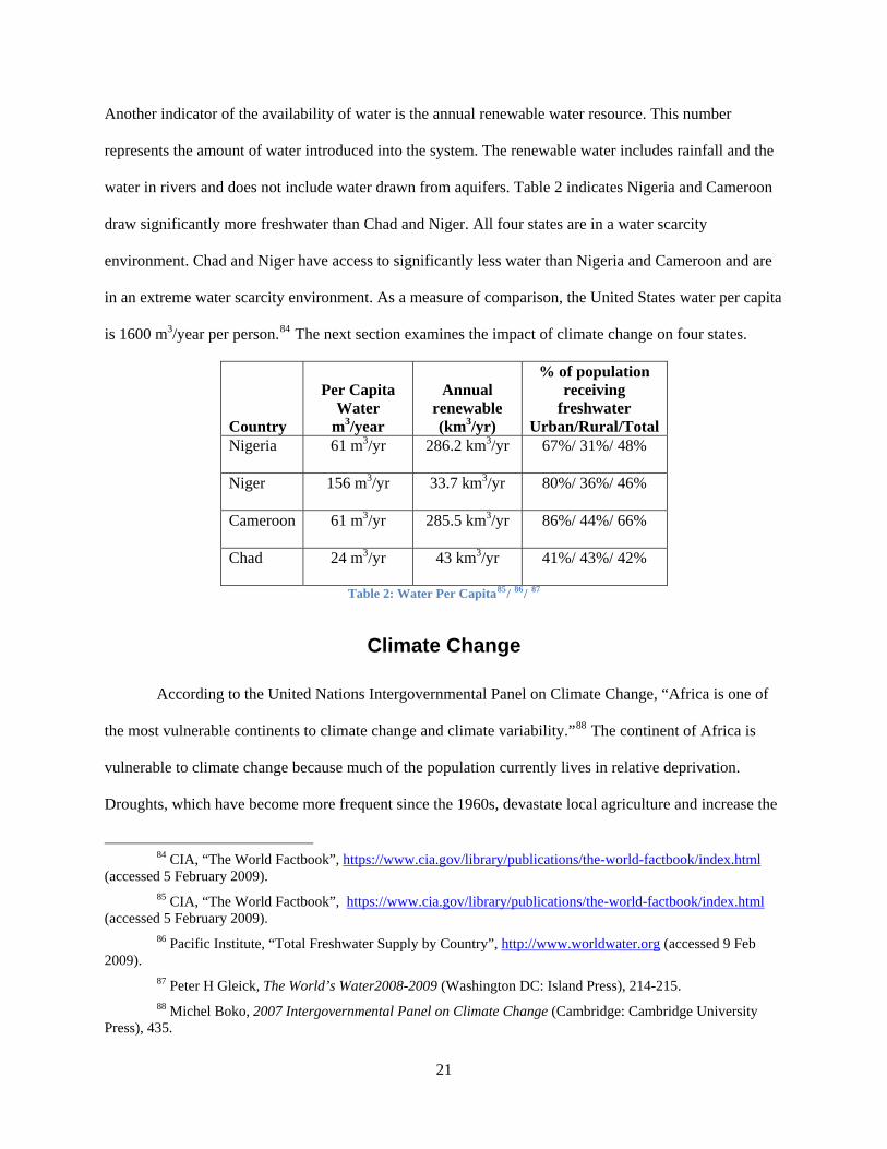
Another indicator of the availability of water is the annual renewable water resource. This number
represents the amount of water introduced into the system. The renewable water includes rainfall and the
water in rivers and does not include water drawn from aquifers. Table 2 indicates Nigeria and Cameroon
draw significantly more freshwater than Chad and Niger. All four states are in a water scarcity
environment. Chad and Niger have access to significantly less water than Nigeria and Cameroon and are
in an extreme water scarcity environment. As a measure of comparison, the United States water per capita
is 1600 m3/year per person.84 The next section examines the impact of climate change on four states.
Country
Per Capita Water
m3/year
Annual renewable (km3/yr)
% of population receiving
freshwater Urban/Rural/Total
Nigeria 61 m3/yr 286.2 km3/yr 67%/ 31%/ 48%
Niger 156 m3/yr 33.7 km3/yr 80%/ 36%/ 46%
Cameroon 61 m3/yr 285.5 km3/yr 86%/ 44%/ 66%
Chad 24 m3/yr 43 km3/yr 41%/ 43%/ 42%
Table 2: Water Per Capita85/ 86/ 87
Climate Change
According to the United Nations Intergovernmental Panel on Climate Change, “Africa is one of
the most vulnerable continents to climate change and climate variability.”88 The continent of Africa is
vulnerable to climate change because much of the population currently lives in relative deprivation.
Droughts, which have become more frequent since the 1960s, devastate local agriculture and increase the
84 CIA, “The World Factbook”, https://www.cia.gov/library/publications/the-world-factbook/index.html
(accessed 5 February 2009). 85 CIA, “The World Factbook”, https://www.cia.gov/library/publications/the-world-factbook/index.html
(accessed 5 February 2009). 86 Pacific Institute, “Total Freshwater Supply by Country”, http://www.worldwater.org (accessed 9 Feb
2009). 87 Peter H Gleick, The World’s Water2008-2009 (Washington DC: Island Press), 214-215. 88 Michel Boko, 2007 Intergovernmental Panel on Climate Change (Cambridge: Cambridge University
Press), 435.
21

risk of famine.89 Climate change also exacerbates floods, which erodes topsoil leaving the soil devoid of
nutrients. Clearly there will be winners and losers in Africa due to climate change. Slight increases in
temperature have changed the ecological landscape of Africa. According to Nigel Arnell, Professor of
Geography at the University of Southhampton, Africa will experience dramatic changes in water stress.
However, western Africa, according to his model, experiences a reduction in water stress.90 While
Arnell’s model anticipates a reduction of water stress in West Africa it does not predict the anticipated
amount of rainfall. The reduction in water stress may prove disadvantageous to the Lake Chad region.
According to Homer-Dixon’s hypothesis of Ecological Marginalization, the relative abundance of water
in West Africa and the decrease of water in other parts results in population migration.91 The population,
seeking better conditions to live, migrate to regions they believe are better suited to support their needs.
The relative abundance of water throughout the Lake Chad basin makes it a likely destination for
migrants. Regardless, the region, already severely stressed, will continue to be water stressed for the
foreseeable future. The confluence of population growth, migration and water stress creates conditions for
famine.
International Law and Cooperative Organizations
Can a state do what it wants to with the water on its sovereign territory? One position argues
water, like any other resource within territorial boundary of a state, can be used in any manner the state
deems fit. The other position argues water, especially rivers that cross state boundaries, is a shared
resource and requires equitable use. Furthermore, upstream states do not have the right to unilaterally
divert waters from the downstream states.92 Unlike the United Nations Convention on the law of the Sea
which specifies its meaning, the only treaties governing the use of transboundary rivers and lakes are
89 Boko, 436. Since 1968 through 1990, West Africa experienced a severe drought resulting in 20 to 40% less annual rainfall.
90 Nigel W. Arnell, “Climate Change and Global Water Resources” Global Environmental Change, no 14(2004): 42
91 Thomas F. Homer-Dixon, 9. 92 Dimitrov, 679.
22
vague. Historically, international law has not been the mechanism resolving water disputes. Rather,
disputes surrounding water have been resolved using bilateral or multilateral agreements or at low
levels.93This section examines the two treaties from the United Nations governing the use of water from
rivers and lakes and the bilateral agreements of the riparian Lake Chad states.94
The 1992 Transboundary Watercourse Convention was the first attempt by the United Nations to
provide a framework for dispute resolution among riparian states. Article 2 of the convention states the
purpose as, “To ensure that Transboundary waters are used in a reasonable and equitable way, taking into
particular account their Transboundary character, in the case of activities which cause or are likely to
cause Transboundary impact.” 95 One of the shortcomings of this convention revolves around establishing
the water required for all riparian parties. These agreements between the riparian states require bilateral or
multilateral agreements. However, the convention provides a forum that allows grieved parties to take
their case to the International Court of Justice.96 The second UN treaty is the Convention on the Law of
the Non-navigational Uses of International Watercourses. Unlike the Transboundary Watercourse
Convention, this treaty specifically addresses the unique characteristics of transboundary rivers. Article 6
of the convention addresses the equitable use of these rivers. It states, “Utilization of an international
watercourse in an equitable and reasonable manner within the meaning of Article 5 (Equitable and
reasonable utilization and participation) requires taking into account all relevant factors and
circumstances including the social and economic needs of the watercourse states concerned; and the
population dependent on the watercourse in each watercourse state.”97 Together, the United Nations
Conventions protect the water rights of the downstream user from abuses of upstream states. The
93 Lowi, 9. 94 Riparian states are situated on the banks of a river or other body of water. 95 United Nations Treaty Collection, Convention on the Protection and Use of Transboundary Watercourses
and International Lakes 1992. http://www.untreaty.un.org/ (accessed 10 February 2009) 96 Ibid. 97 Ibid
23

conventions provide the foundation for the development of bilateral and multilateral water agreements
from the riparian states.
The United Nations Convention specifies that transboundary resources ought to be equitable. The
riparian states develop water use agreements ensuring their states’ interests have been achieved. The
author expected to find water agreements between all the riparian states in the Lake Chad Basin.
However, there is only one bilateral agreement on equitable water between Nigeria and Niger. The water
agreement describes the shared water catchments between the two states; rivers, pools, seasonal streams
and pools, and aquifers.98 The largest catchment is the Komadugu-Yobe River. This river provides a
potential flow of 1,296 million m3 of water, however, catchments along the river’s path decreases the
actual flow of the river.99 According to the World Bank, only 1% of the rivers’ original waters makes it to
Lake Chad.100 The river terminates into Lake Chad, providing roughly 2% of its waters.101 The second
and third largest water catchments are shallow aquifers replenished by seasonal flooding of the
Komadugu Yobe River. The Maggia-Lamido and Gada-Gulbin Maradi catchments provide maximum
capability of 292 million m3 of water.102 The last catchment is a seasonal stream, the Tagwai-El Fadama,
fed by flooding.
These catchments provide water for a significant portion of the two states’ populations.
According to the bilateral agreement, the catchment provides water for over twelve million people, ten
million Nigerians and two million Nigers.103 While the two countries have an agreement on water use,
water distribution is not equal. In this water agreement, only 150,000 Nigers have access to perennial
98 Integrated Ecosystem Management in Shared Catchments Between Nigeria and Niger, http://www.gefweb.org (accessed 10 February 2009)
99 Ibid. 100 The World Bank, Reversal of Land and Water Degradation Trends in the Lake Chad Basin, prepared by
the Africa Safeguards Policy Enhancement Team, 2002, 7. 101 Eric O. Odada and Lekan Oyebande and Johnson A. Oguntola, “Lake Chad: Experience and Lessons
Learned Brief” http://www.iwlearn.net (accessed 25 Aug 2008), 80. 102 Integrated Ecosystem Management in Shared Catchments Between Nigeria and Niger. The Gada-Gulbin
Maradi catchment is solely dependent on seasonal flooding and provides 200 million m3 of water. Because of its seasonal nature, the water is available from July to October.
103 Ibid.
24

waters. Nearly two million Nigers are reliant on seasonal water, and are extremely vulnerable to droughts.
During the mid 1960s, four years after Cameroon and Nigeria’s independence, the four riparian states
formed the Lake Chad Basin Commission to manage the equitable use of the basin’s waters.
The Lake Chad Basin Commission (LCBC) is a multi-lateral organization to equitably manage
resources, promote economic development, and maintain peace and security of the basin.104 Cameroon,
Nigeria, Niger and Chad established the Lake Chad Basin Commission in 1964 as charter members. The
original Lake Chad basin included 427,000 km2 with the majority of the land in Chad (42%).105 The
commission was later expanded to include the Central African Republic as a full member and Sudan as an
observer.106 The additional states’ participation in the commission brings the land management area to
2,434,000 km2. The LCBC specifically prohibits member states from undertaking any unilateral action
that negatively affects the lake or the lake’s basin. However, the commission recognizes the water rights
of the states within the basin.107 The LCBC also arbitrates riparian disputes. The commission attempted to
arbitrate the territorial dispute between Nigeria and Cameroon in 1994. The dispute highlighted the
ambiguities of the states’ boundaries running through the lake.
Lake Chad
As discussed previously, Lake Chad is a transboundary water source. The northern part of the
lake and basin lie in Sahelian region, which is the transition of the Sahara Desert and the savannah
plains.108 The tributaries of the lake also flow through these countries and the Central African Republic.
Measurements of the lake in the 1960s, at the water’s most recent high point, recorded it as the fourth
104 Lake Chad Basin Commission. 17 December 2008. Roundtable: To Save Lake Chad Background Paper.
Sirte, Libya, 4. 105 Luke Oneykakeyah, “Lake Chad, A Study of a Drying Freshwater Body”
http://riversymposium.com/index.php?element=ONYEKAKEYAH (accessed 15 February 2009). 106 Ibid. 107 Ibid. 108 Global International Waters Assessment, Lake Chad Basin GIWA Regional Assessment 43 (Kalmar:
United Nations Environment Programme, 2004), 25.
25
largest lake in Africa and the second largest endorheic lake in the world.109 The growing population and
change in climate dramatically changed the properties of the lake over the last 40 years. In 1963 Lake
Chad covered over 25,000 km2 or roughly the size of New Jersey. Today the lake has shrunk to 1,350 km2
losing almost 96% of its waters.110 The water on Nigeria’s side of the lake has completely receded beyond
its border. Currently only small pools of water remain in Nigeria. The properties of the lake make it
vulnerable to minor fluctuations. The lake’s average depth is three meters and throughout the lake are
marsh banks, reeds and small islands.111 There are two pools, northern and southern, averaging a water
depth of four to seven meters. Currently, the pools are the only large pools of standing water in the lake,
which are the direct recipients of tributary waters. The shallow depths of the lake ensure the shorelines
continuously ebb and flow during the dry and wet periods. Fluctuations of the lake’s size have been
common throughout history. The lake has completely dried up four times from 1400 to the present.112
Lake Chad’s receding waters go largely unreported in current maps and atlases. Maps of the region depict
Lake Chad’s borders at the 1960 high water mark which can lead the casual observer and researcher with
the false impression that there is no current water shortage there. Accurate maps made today would
depict a very different Lake Chad with only the northern and southern pools.
The four riparian states exist in a water scarce environment. Climate changes reducing the
rainfalls proved devastating to ecosystem supporting Lake Chad. The 1973-74 and 1983-84 Sahelian
droughts fundamentally changed the ecosystem supporting the lake. Increased desertification of the
region pushed the Sahara Desert 100 km south.113 The desert’s move south correspondently moved the
Sahel south. The change of the ecosystem affected the long term rainfalls which the Lake Chad system
depends upon. As a result of the two droughts and increased desertification, the average rainfall decreased
109 Lake Chad Basin Commission, 2. Endorheic means the lake only has input tributaries. The waters of
Lake Chad do not empty into another river, rather terminate at the lake. 110 Odaba, 75. 111 Ibid, 80. 112 Fred Pearce, When the Rivers Run Dry: Water-The Defining Crisis of the Twenty-First Century (Boston:
Beacon Press, 2006), 85. 113 Global International Waters Assessment, 44.
26

30%.114 The reduction of rainfall and the corresponding drop in the lake affects the replenishment of
shallow aquifers.
The lake and its floodplains serve a vital role recharging the basin’s aquifers. The basin has three
aquifers, upper, middle and lower, all of them shared by the four riparian states.115 These aquifers provide
water to the water starved populous, and become vital to human survival during times of drought. The
upper aquifer, approximately 30 meters from the surface, recharges through water seepage into the soil
from streams, rivers, wetlands and the lake.116 During the past droughts, the upper aquifers were exploited
beyond their ability to recharge and have lowered the mean water table.117 The middle aquifer lays 450 to
620 meters below the surface and extends beneath the four riparian states. These aquifers possess
substantial waters, but currently are too expensive to extract.118 The lower aquifer exists, but very little
information is available. While climate changes factor into the current recession of water, more people
than previously recorded are getting their water from the lake and its feeder rivers.
Tributaries
Lake Chad gets its water from three sources, two tributary river systems and seasonal rainfall.
Both of these rivers, Chari-Logone and the Komadugu Yobe River are transboundary and human
developments on the rivers create additional stress on the system. This section addresses the geography of
the rivers, the irrigation projects and the environmental considerations.
Chari-Logone River Sub-system
The Chari-Logone river system is a combination of rivers and streams converging into the Chari.
This river system provides 95% of Lake Chad’s waters. Feeder tributaries from Chad, Cameroon and the
114 Ibid, 45. 115 Ibid, 15. 116 Ibid. 117 Ibid, 51. 118 Ibid, 15.
27

Central African Republic support the Chari-Logone river system.119 The river stretches 1,400 km and its
basin covers 650,000 km2.120 Over the last 40 years, the water discharge into the lakes as dropped 55%.121
Recently, the waters from the Chari-Logone system decreased output from 33.3 billion m3/yr average to
20.7 billion m3/yr.122 As previously discussed the mean rainfall throughout the basin decreased and the
irrigation projects further reduce the flow of water to the lake and wetlands.
Within Cameroon, the Logone River was dammed on the upper part of the Waza-Logone flood
plains. The Maga Dam was built in 1979 and spans 30 km with a catchment area of approximately 6,000
km2. The purpose of the dam was to alleviate food security problems through the cultivation of rice, fish
farming and also short term economic benefits from the construction efforts.123 Discharge water from the
river system decreased, further reducing the size of the lake.124 Rather than provide economic stimulus,
the dam damaged the flood plain and decreased economic value of the flood plains.
The Waza-Logone flood plains are a vital asset to Cameroon. The flood plains extend 8,000 km2
throughout the northern areas of Cameroon and border Nigeria and Chad. The flood plains prior to the
construction of the Maga Dam introduced $10 million into the regional economy through agriculture and
fishing.125 The dam, while controlling the flood waters to protect rice cultivation, devastated the
downstream flood plains. The flood plains, once 8,000 km2 shrank to 964 km2.126 The economic cost to
the downstream population in Cameroon and Chad exceeds $2.4 million a year. The loss of the seasonal
flooding reduced agricultural yields by depriving farmers of the seasonal flood waters for their field. The
reduction of the flood waters also had an effect on the fisheries. With smaller seasonal floods, spawning
119 Ibid, 18. 120 Ibid, 21. 121 Ibid, 46. 122 Ibid, 21. This average dates from 1932-1991. The reason for the decrease are climate related and
diversion of the waters. 123 Ibid, 46. 124 The GIWA asserts the Maga Dam curtailed the downstream discharge by 30%. 125 The World Conservation Union, “Waza Logone Floodplain, Cameroon: Economic Benefits of Wetland
Restoration” May 2003. 126 Ibid.
28

habitats decreased. As a result, the floodplains experienced a 90% decline in fish yields.127 The flood
plains also provide pasture areas during the dry season. Prior to the Maga Dam, approximately 250,000
cattle and sheep exclusively grazed on the grasslands. The reduction of water had a corresponding impact
on the grasslands. The grasslands are smaller, the soil no longer supports the perennial grass, and the
competition for the available grass has increased.128 Most importantly, the loss of the seasonal flooding
affected the aquifers in the Waza-Logone region. The aquifers provide water for all essential purposes
during the dry season. Without the seasonal floods recharging the upper aquifers, the region’s water table
lowers and existing water holes dry out. This places the population, already in a water scarce
environment, in a precarious position during droughts.
The Chari-Logone river system is a vital component to the Lake Chad system. The waters from
Chad, Cameroon and the Central African Republic provide the lake with 95% of its waters. Over 220,000
people rely on the rivers’ waters for drinking water, agriculture, and fishing.129 The Maga Dam is just one
example of the effects of human interaction with the system. The Chari-Logone River’s reduction of
waters to Lake Chad adversely affects the downstream population and the environment.
Komadugu-Yobe River Sub-system
The other major tributary of Lake Chad is the Komadugu-Yobe River system. The river system
comprises of rivers converging into the Yobe River and its basin covers 148,000 km2.130 The river system
provides less than 2% of the lakes waters and supports the Hadejia-Nguru wetlands, a vital economic
center for the region’s population. 131 The Joint Wetlands Livelihood Project estimates the basin supports
15 million people through agriculture, fisheries, and water.132 Similar to the Chari-Longone River, the
127 Ibid. 128 Ibid. 129 Ibid. 130 Global International Waters Assessment, 88. 131 Ibid. 132 Muhammad J. Chiroma, “Water Management Issues in the Hadejia-Jama’are-Komadugu-Yobe Basin”,
Joint Wetlands Livelihood Project, 1.
29

Komadugo-Yobe River is transboundary flowing from Nigeria through Niger and terminating at Lake
Chad. The Komodugu-Yobe River system is also heavily dammed to meet agricultural and water
demands of the states. The first dam constructed, the Tiga Dam, was completed in 1974. This is the
largest dam on this river system and provides water for the Kano River Irrigation Project.133 The rivers
currently support twenty dams that severely curtail the flow of water throughout the system.134 In addition
to the legitimate irrigation projects, farmers illegally cut channels into the river to divert waters to their
fields. As a result of water diversion projects, less than one percent of the water terminates into Lake
Chad.135
The irrigation projects throughout the system affect the Hadejia-Nguru Wetlands. The wetlands,
which are dry for most of the year, provide the population with income from agriculture, fishing,
pasturing of livestock and firewood.136 The wetlands are relatively flat areas allowing seasonal
floodwaters to meander. The upstream irrigation projects capture the seasonal floods and reduced the
water to the downstream floodplains curtailing the areas it covers. Prior to the irrigation projects, the
Hadejia-Nguru wetlands covered 300,000 hectares (ha). Today, the wetlands cover 80,000 ha, a seventy-
four percent reduction.137 The reduction of wetland size corresponds to an economic cost of $11 million
(US).138 Similar to the Waza-Logone floodplains, the change in the natural progression of floodwaters has
affected ecological balance. The river system relied on the floodwaters to clear the rivers of silt build up.
The siltation of the river has led to at least five species of fish disappearing from the region.139 The
reduction of flood waters also affects the shallow aquifers of the region. The aquifers provide routine
133 Chiroma, 3. 134 Global International Waters Assessment, 90. 135 Chiroma, 2. 136 Edward B. Barbier, Upstream Dams and Downstream Water Allocation: The Case of the
Hadejia’Jama’are Floodplain, Northern Nigeria (Stanford, CA: Center for Environmental Science and Policy, 2002), 8.
137 Barbier, 8. The author used consistently used the high estimates for the total size of the wetlands and the corresponding reduction. Also, 100 ha equals 1km2.
138 Global International Waters Assessment, 91. 139 Ibid.
30

water for the region and insurance waters during times of droughts. A decrease of water downstream
affects not only the environment and economics of the region, but threatens the survival of the population
reliant on the water.
The Komadugu-Yobe River system does not contain enough water to support the population of
the region. According to Global International Waters, 20 million people rely on the rivers for water. This
represents 55% of the entire Lake Chad basin’s population.140 Despite the extensive river system, the
flood plains are an extremely water scarce region. The population, agricultural and livestock water
requirements exceed the system’s capability by 260%.141 With population growth at 2.6% and
desertification of the Sahel region causing population migration to the region, competition for water will
grow. The competition for water increases the potential for conflict.
Lake Chad Basin Demographics
The four riparian states’ population is disproportionate to the states territory within the Lake Chad
Basin. The Global International Waters Assessment (GIWA) estimates the population of the basin at 37
million.142 Nigeria has the largest population with the smallest amount of land. Roughly sixteen percent
of the Nigerian population, or 23 million, live within 179,300 km2 of the basin.143 The Nigerian
population density is 128 people per km2, which is less than the national average. Chad’s population
within the basin is eight million.144 Unlike Nigeria, Chad’s land within the basin is the largest at
1,123,400 km2 with a population density of seven people per km2.145 Cameroon and Niger both estimate
their population equally at 2,000,000 people. Cameroon’s population density is much higher, 42 people
140 Ibid. 141 Ibid. 142 Global International Waters Assessment, 29. 143 Ibid, 29, 14. 144 Ibid, 29. 145 Ibid, 14.
31

per km2, compared with Niger at 3 people per km2.146 The current growth rates, assuming zero outside
influences, predict the population of the basin to be 74 million people in 2034.147 The number does not
factor in the impact of periodic droughts or refugees entering into the basin.
Factors Nigeria Cameroon Niger Chad Total Population 146,255,312 18,467,692 13,272,679 10,111,337Population Density per sq km 158 39 10 8Population Growth Rate 2.03% 2.22% 2.88% 2.20%GDP Growth Rate 6.20% 4% 4.50% 1.70%HDI Poverty 37.00% 31.50% 55.10% 56.20%Democracy Level 3.52 3.27 3.54 1.65
Type of Governance Federal
Republic Republic Republic Republic
Table 3: Riparian State Demographics148/ 149/ 150
The majority of the population relies on the lake or the water from the flood plains for their
livelihood. Sixty percent of the populations in the four countries earn their livelihoods from agriculture.151
As mentioned before, agriculture consumes the majority of water. Niger’s population has outmatched its
ability to produce required food products. Niger is currently a food importer, and the population is
vulnerable to droughts. Last year, the UN World Food Programme (WFP) provided $42 million dollars in
food aid to Niger.152 The change in climate also affected Niger’s ability to grow food. The desertification
of the Sahel region is drying up residual waters and land. The GIWA estimated Niger irrigates 2,000 km2
146 Ibid, 14/29. 147 Using the formula to determine population growth t=.69/pop growth rate. The author used 2.7%
population growth rate for the LCB provided by the GIWA. 148 CIA, “The World Fact Book” https://www.cia.gov/library/publications/the-world-
factbook/geos/cm.html#top (accessed 21 February 2009). 149 Laza Kekic, “The Economist Intelligence Unit’s Index of Democracy”
http://www.economist.com/media/pdf/DEMOCRACY_INDEX_2007_v3.pdf (accessed 21 February 2009) 150 United Nations Development Programme, “2008 Statistical Update”,
http://hdr.undp.org/en/countries/alphabetical2008/index.htm (accessed 21 February 2009) 151 Global International Waters Assessment. 30. 152 World Food Programme, “Countries, Niger”, http://www.wfp.org/countries/niger (accessed 21 February
2009)
32

of the 674,800 km2 within the basin.153 The area of irrigated land within Niger will decrease with
continuation of desertification. The people of the basin also rely on fishing to survive. Fishing provides
livelihood for 10 million people within the basin and provides the region with $23 million dollars in
revenue and is a dietary stable throughout the basin.154 The last major occupation of the region is
livestock. In Chad only 25% of the land is irrigated for agriculture while 50% of the total land is used for
livestock pasture lands.155
The Lake Chad basin is a poor region of Africa. It is estimated 60% of the population lives on
under $2 (US) a day.156 Niger and Chad are the regions poorest countries. In Niger, 63% of the population
subsides on less than $2 a day. The rural areas of Niger are poorer than the cities. Eighty six percent of
the poor in Niger live in the countryside.157 Chad also suffers from high poverty levels. Unfortunately,
there is no data on the extent of poverty; however it is known that 80% of Chadians live in rural areas.
The confluences of demographic factors of the basin provide a bleak future for the region. The
basins’ population is growing, the economies are stagnant and human and climate factors reduce available
water which provides the means for livelihood. The reduction of the floodplains’ water from both
tributaries lowered the regions’ water tables. The reduction of waters to the lake and wetlands threatens to
eliminate a major source of income for the people in the basin. The confluence of these factors is likely to
increase regional tensions.
153 Global International Waters Assessment, 32/14. 154 Ibid, 33. 155 Ibid, 32. 156 Ibid, 34. 157 Ibid, 34.
33

Previous Conflict Surrounding Lake Chad
Conflict is no stranger to the riparian states surrounding Lake Chad. In April 1983, Nigeria’s and
Chad’s military engaged in violence over territorial disputes, causing over 100 casualties.158 Refugees
flowing from Chad to Nigeria fueled the border dispute. Following this incident, Nigeria closed the
border to Chad and it remained closed until 1986. In 1981, Cameroon and Nigeria clashed over territorial
disputes in the oil rich areas off of Rio del Rey.159 More relevant to water conflict, the waters of Lake
Chad were directly responsible for interstate conflict. As the waters receded from Nigeria’s shoreline,
villagers followed the waters to neighboring Cameroon, eventually establishing thirty three villages under
Nigerian civil and military administration.160 This section lists the factors contributing to migration of
Nigerians culminating in legal arbitration through the International Court of Justice. The reasons for the
migration are the receding waters, the region’s population increase, and the undetermined borders.
As discussed earlier, the waters of Lake Chad fluctuate with the seasonal rains. While the water
recedes according to the natural laws of physics, there is no redistribution of state allocated waters.
Nigeria’s shoreline receded disproportional to the other riparian states. Nigerian fishermen, having to
travel further to reach the lake, established resting places on newly formed islands. Katti Kime, was the
first rest area established in 1959 and these settlements continued throughout the 1960s.161 These resting
places soon became villages as the shoreline continued to recede. According the Nigeria’s counter-
memorial,“During the drought of 1973-1975, the level of the Lake receded considerably. Nigerian
fishermen followed the receding Lake shore, establishing villages such as Darak, Naira and Ramin
158 Peter Wallensteen & Margareta Sollenberg, “Armed Conflict 1989-98”, Journal of Peace Research 36,
no 5 (1999): 602. 159 Nigeria: Local and Bilateral Issues, 1991, http://www.country-data.com/cgi-bin/query/r-9454.html
(accessed 16 February 2009). 160 International Court of Justice, “Counter-Memorial of the Federal Republic of Nigeria 1994”,
http://www.icj-cij.org/docket/files/94/8602.pdf (accessed 17 February 2009), 338. 161 Ibid, 335.
34
Drinna.”162 From 1959 to 1994, 60,000 Nigerians followed the receding water, fishing and cultivating
their crops within Cameroon’s borders.163 As the resting stops developed into villages, the Government of
Nigeria began treating them as sovereign territories. The Nigerian state of Borno administered the thirty
three villages within Cameroon. The Nigerian state levied taxes, provided essential services such as
police, official census, the state appointed village leaders (bulama), established a public school systems,
provided medical support, established fishing regulations and licensed fishermen.164 Nigeria considered
the Cameroon Lake Chad villages to be sovereign territory of Nigeria and the people within those villages
identified themselves as Nigerians.
Cameroon viewed Nigeria’s acquisition of its territory from a different perspective. The
government of Cameroon asserts Nigeria conducted an invasion of their sovereign territory. In their
Additional Application of 6 June 1994, Cameroon accused Nigeria of, “(V)iolating international
obligations, under treaty and customary international law, by occupying, with the support of its security
forces, parcels of Cameroonian territory in the area of Lake Chad”.165 The issue of territorial sovereignty
was obscured by the delineation of the state borders through Lake Chad. These border disputes can be
traced back to European colonization of Africa.
The empires of France, Germany and Great Britain, while administering colonies in West Africa,
attempted to delineate the borders of the four riparian states. When the states gained independence in
1960, the borders of Lake Chad area were unclear. Cameroon recognized the Lake Chad borders
delineated in the Thomson/Marchland Declaration of 1929. The declaration specified the tri-border point
(Chad, Nigeria and Cameroon) with a straight line drawn to the mouth of the Ebeji River.166 Nigeria did
not accept the Thomson/Marchland Declaration; rather they believed demarcation of the border was not
162 Ibid, 335. A counter memorial is a legal document submitted to a court of law in response to grievance.
This information is provided to the court to establish facts prior to arbitration. 163 Ibid, 337. 164 Ibid, 431. 165 Ibid, 632. 166 International Court of Justice, Yearbook 2002-2003 (Hague: United Nations International Court of
Justice, 2006), Google Book Search.
35
resolved. Nigeria argued the declarations were preliminary in nature and not binding.167 They asserted
demarcation of the border was the responsibility of the Lake Chad Basin Commission, which had not
been accepted by all four states. Since the state’s borders were unclear, Nigeria asserted sovereignty not
on the argument of territory; rather on Cameroon’s acquiesce of Nigeria’s expansion.
Eight years after Cameroon’s request for arbitration, the International Court of Justice (ICJ)
rendered a decision. The Court demarcated Lake Chad at the Thomson/Marchland Declaration and
decided in favor of Cameroon.168 The judgment requested Nigeria to remove all military and security
forces from the Lake Chad disputed area. In December of 2003, the UN Office for the Coordination of
Humanitarian Affairs reported the first Nigerian villages within Cameroon are now under the
administration of Cameroonian government.169 This incident of water conflict was resolved, but potential
conflicts continue to threaten the stability of the region.
Future Concerns for the Lake Chad Basin
Human and environmental factors continue to stress the Lake Chad system. This section
examines the effect of conflict and desertification in neighboring states as it relates to refugees. Refugees
fleeing the regional conflicts in Chad and Sudan are migrating into the Lake Chad basin. The changes in
climate, specifically the desertification of the northern Sahel, have increased the flow of displaced people
to the Lake Chad area. Also, the potential for oil exploitation in the recently receded lake’s waters
threaten to destabilize the stressed region.
Refugees into the Lake Chad basin continue to stress an already stressed system. Refugees fleeing
the fighting in Sudan have entered into Chad. The WFP estimates 435,000 refugees reside within Chad’s
167 International Court of Justice (1999), 375. 168 International Court of Justice Press Release, “The Court determines the boundary between Cameroon
and Nigeria from Lake Chad to the Sea.”, http://www.icj-cij.org/docket/index.php?pr=294&code=cn&p1=3&p2=3&p3=6&case=94&k=74 (accessed 18 February 2009).
169 Humanitarian News and Analysis, “Cameroon-Nigeria: Handover of Lake Chad villages begins”, http://www.irinnews.org/PrintReport.aspx?ReportID=47603 (accessed 16 February 2009).
36

borders.170 Chadian refugees recently crossed the borders into Nigeria and Cameroon. Last year,
Cameroon absorbed 300,000 to 500,000 Chadian refugees.171 According to the same report, Nigeria also
began receiving Chadian refugees, although the number of refugees is smaller, 3,500.The fewer numbers
of refugees into Nigeria is partly because the lake provides a natural obstacle. Refugees into the Lake
Chad Basin increase the amount of water required to sustain the population’s drinking, sanitation,
agriculture, fishing and livestock waters. Another concern is future oil exploration throughout the Lake
Chad Basin.
With the exception of Niger, the riparian countries in the Lake Chad Basin are oil producing
countries. Geologists have long suspected oil reserves beneath the lake bed.172 With unfettered access to
the lake, these states are capitalizing on these natural resource finds. According to the BBC, Nigeria has
been negotiating contracts with China for the extraction of oil from its side of Lake Chad.173 The author
has been unable to find the suspected amount of oil reserves beneath the lake, but it is reasonable to
assume the exploration of petroleum in the basin will have some impact on the fragile environment. The
final concern surrounding the lake is the rise of terrorism.
Throughout the region there is a low level of violence from terror organizations. The most
prominent organization, the Nigerian Taliban, operates from the Lake Chad Basin.174 According to Jane’s
Intelligence Review, the Nigerian Taliban operates mostly from the Nigerian state of Kano and uses the
ambiguity of the border to cross into neighboring Cameroon and Niger.175 This terrorist organization has
170 The World Food Programme, “Countries: Chad”, http://www.wfp.org/countries/chad (accessed 21
February 2009). 171 Country Watch, “Thousands of Refugees Fleeing Chad Cross Border into Cameroon, Nigeria”,
http://search.countrywatch.com.lumen.cgsccarl.com/cw (accessed 18 February 2009). 172 Jane’s Intelligence Watch, “Lake Chad Basin looks to ride wave of concern” 13 July 2005,
http://www.search.janes.com.lumen.cgsccarl.com (accessed 18 February, 2009). 173 "Nigeria, China sign oil, technology pacts." BBC Monitoring Africa 27 April 2006.
http://www.proquest.com.lumen.cgsccarl.com (accessed March 7, 2009). 174Richard Reeve, Jane’s Intelligence Watch, “Islamic militants establish Lake Chad networks”, 18 October
2004, http://jir.janes.com.lumen.cgsccarl.com (accessed 18 February 2009). 175 Jane’s World Insurgency and Terrorism, “Nigerian Mujahideen Groups” 4 March 2009,
http://search.janes.com.lumen.cgsccarl.com/Search/documentView.do?docId=/content1/janesdata/binder/jwit/jwita0
37
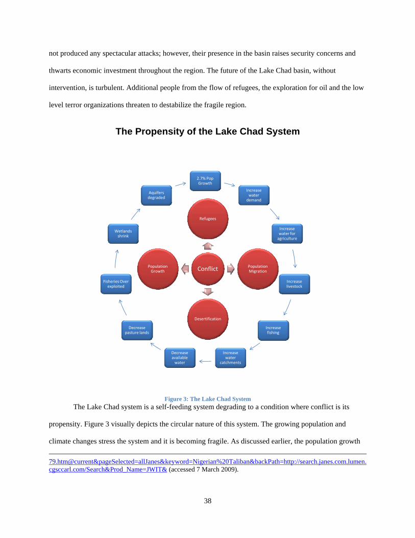
not produced any spectacular attacks; however, their presence in the basin raises security concerns and
thwarts economic investment throughout the region. The future of the Lake Chad basin, without
intervention, is turbulent. Additional people from the flow of refugees, the exploration for oil and the low
level terror organizations threaten to destabilize the fragile region.
The Propensity of the Lake Chad System
2.7% Pop Growth
Increase water demand
Increase water for agriculture
Increase livestock
Increase fishing
Increase water
catchments
Decrease available water
Decrease pasture lands
Fisheries Over exploited
Wetlands shrink
Aquifers degraded
Conflict
Refugees
Population Migration
Desertification
Population Growth
Figure 3: The Lake Chad System
The Lake Chad system is a self-feeding system degrading to a condition where conflict is its
propensity. Figure 3 visually depicts the circular nature of this system. The growing population and
climate changes stress the system and it is becoming fragile. As discussed earlier, the population growth 79.htm@current&pageSelected=allJanes&keyword=Nigerian%20Taliban&backPath=http://search.janes.com.lumen.cgsccarl.com/Search&Prod_Name=JWIT& (accessed 7 March 2009).
38
rate throughout the basin is 2.7%. Assuming the rate stays constant, the population, currently at thirty
seven million, doubles by 2034. The doubling of the population affects Nigeria the most. Nigeria has the
smallest amount of territory in the basin and the highest population per km2. Within the basin, Nigeria
gets its water from the Komadugu-Yobe Rivers. At its current flow, the river is inadequate to meet all
water requirements for the population, agriculture, and livestock. As the upstream Nigerian population
increases, the downstream users’water scarcity situation continues to deteriorate. The scarcity of water in
Niger will trigger human migration to water rich areas specifically Nigeria. Concurrent with population
growth and human migration, regional conflicts increase the flow of refugees into the basin. The refugees
from Sudan and Chad flowing into water rich Nigeria and Cameroon support this assertion.
Nigeria continues to plan and construct more agriculture and water catchments along the
Komadugu-Yobe River. While projects in the region are plagued with funding problems, any additional
catchments along the river decrease the water available to downstream users, accelerating the migration
of people to water rich areas. Population increases throughout the basin increase the demand on shallow
aquifers. People, out of necessity, exploit the aquifers beyond safe recharge levels. This causes water
tables to lower and reduces the recharge of the upper aquifers. As the demand for water increases, the
middle aquifers are further exploited. The middle aquifers, located 420-620 meters below the surface,
recharge at a slower rate and are considered non-renewable water.176
Population growth affects the water available in the Chari-Logone Rivers. The river system
provides 95% of Lake Chad’s water. With the Chari-Logone system, Chad, the least populated state, is
upstream and Cameroon, more populated, is downstream. Chad currently exists in a water scarce
environment. Refugees from the Central African Republic and Sudan add additional stress to the Chad’s
water scarcity. While humanitarian aid through UNICEF and WFP provide assistance, the exploding
population increases Chad’s water use. Within Cameroon, upstream reduction of water affects the
downstream Waza-Logone flood plains. These flood plains are a vital element to the Cameroon’s
176 The lower aquifers take as long as 1000 years to recharge the water extracted.
39

economy and for the population’s food supply. Unlike Nigeria and Niger, there are no shared water
agreements ensuring equitable use. Furthermore, the Lake Chad Basin Commission has been unable to
bring all parties to the negotiating table to establish a lasting water agreement.
Lastly, climate change throughout the region affects the system. The droughts of the 1970s and
1980s increased the desertification of the region. The Sahara Desert expanded 100 km southward into the
basin. As pasture lands in Niger and Chad transform to desert, human migration south into the Lake Chad
Basin accelerates. Again, Nigeria is the likely destination for this migration due to its regionally strong
economy.
The propensity of Lake Chad is increased regional conflict. The effects of climate change,
population growth, and refugees all consume more water, not less. The tributaries feeding the lake
continue to be exploited reducing available water to the lake. As the lake recedes border issues become
more frequent. The ICJ’s 2002 ruling demarcated the border of the four states through Lake Chad, but
only Nigeria and Cameroon recognize this border. Chad’s and Nigeria’s past border conflicts indicate a
resonant level of conflict between the states. Further, all four states have border disputes with each other.
Finally, petroleum exploitation of the region increases the relative worth of the land and is a source of
tension throughout the region.
Refugees Implications for USAFRICOM
The current propensity for conflict around Lake Chad revolves around the impact of human
migration internally within the four states and externally throughout the region. If USAFRICOM chooses
to mitigate the region’s insecurity, they must use a whole of government approach. This section addresses
USAFRICOM’ response within the diplomatic, informational, military and economic instruments of
power.
The diplomatic efforts focus on prevention of the crisis conditions triggering human population
movement. USAFRICOM efforts would focus on actions provided by the United States Agency for
International Development (USAID). While currently in the region, USAID’s mandate should be
40

expanded to include the four riparian states and establish programs specifically addressing the situation
within the Lake Chad Basin. A strong USAID response to the region also serves as a bridge for the
involvement of international organizations such as the WFP, the World Bank, and the United Nations
High Commissioner on Refugees (UNHCR). Similar to USAID, these organizations already operate
within the basin, but not at levels required to prevent human migration. These organizations need to work
with and through the LCBC to ensure humanitarian and development projects address the needs of the
people and not the riparian states’ coffers. Building the credibility of the LCBC both within the region
and internationally is critical for success. If the LCBC fails, the riparian states have no incentive or
method ensure water sharing.
USAFRICOM Strategic Communications efforts need to reinforce the legitimacy and
effectiveness of the multilateral organizations, specifically the LCBC. The tipping point for conflict
within the basin, primarily from human migration, is the disillusion of the LCBC. Currently this
organization has international legitimacy. They have secured loans from the World Bank for irrigation
schemes along Lake Chad’s tributaries and reports progress to the United Nations Development
Programme. However, within the basin, the LCBC appears to have weaker influence over its members.
The lack of bilateral or multilateral water sharing agreements is evidence of the commission’s inability to
influence member nation’s negotiations.
AFRICOM’s military response to any refugee problem depends on the international credibility of
the UN and the African Union (AU). Prior to an increase of widespread humanitarian problems, a
combined military effort of the UN or AU might be necessary to establish security for IGO and NGO
relief organizations. While there is a low level terror threat to the region with the Nigerian Taliban,
conditions in the region do not necessitate additional security to provide humanitarian assistance. When
conditions deteriorate, a military response serves two purposes. Initially a combined response with
Africans in the lead stems the flow of refugees. Massive refugee flow from Chad and Niger into
Cameroon and Nigeria creates additional stress on these fragile regimes. For example, Foreign Policy
41
ranks Nigeria as the 18th most unstable regime.177 Since roughly half of the population of Africa within
Nigeria’s borders, it is reasonable to assume an implosion of the government would have catastrophic
effects on neighboring states. The second use of the military is to assist in the distribution of humanitarian
assistance. These efforts should be focused within the borders of the refugees exporting states. A military
intervention of this magnitude would be a long term commitment and would only terminate when the
conditions both environmental and governmental stabilize and can operated within the new norm.
The last instrument of power, economics, is necessary to stabilize the region preventing the onset
of massive human migration. The tools of this instrument of power are the same organizations secured by
the diplomatic efforts. USAFRICOM plays a primary role in with influencing the organizations priorities.
The four riparian states must build developmental capacity to reverse the propensity for human migration.
Water catchments must be built and the water shared by all LCBC members. Currently the World Bank
finances water catchments within Nigeria; however, these construction projects often die on the vine
because of a lack of funding. Rather than building catchments for the exclusive use of one state,
catchments should become a shared resource managed by an LCBC. Funding for development projects
need to focus on creating prosperous conditions in Niger and Chad. A relative increase of prosperous
conditions and access to shared waters in these states would likely decrease the flow of people into
Cameroon and Nigeria.
USAFRICOM has an opportunity to stabilize the most populated region in Africa. There are no
clear cut solutions to complex problems within the Lake Chad Basin. Certainly the solutions do no reside
solely within a military organization. However, it is clear the best mitigation for refugees is to prevent the
crisis. USAFRICOM is uniquely suited for this challenge because of their interagency structure. Military
operations concerning refugees are established after the crisis has emerged. Unlike diplomatic and
economic efforts, military operations also put a US face on operations which may not be received well
throughout the region.
177 “The Failed States Index 2008”, Foreign Policy,
http://www.foreignpolicy.com/story/cms.php?story_id=4350&page=1 (accessed 12 April 2009).
42

Section 4: Conclusion
The analysis of the two case studies supports the author’s hypothesis. The reduction of water
levels in Lake Chad will increase regional conflict. Conflict throughout the region manifests itself through
population migration stressing the system. At some point, the effects of population growth, migration into
the system, climate change and refugees will destabilize the system. The destabilization of the Lake Chad
system will not result in interstate conflict; however, the institutions ensuring equitable water use
throughout the region will fail. There are several emerging properties from the natural resources case
studies. The first emergent property prevalent in both case studies is possession of the resource means of
legitimacy. In the Spratly Islands, each of the claimants maintains control of their islands through
physical possession by their respective militaries. Once possession of the island is established, no state
has used violence to enforce their claim. While states refrain from violence over the islands, they will
protect their economic resources. The Philippine example of seizing Chinese fishermen under the auspice
of violating the Philippine’s Economic Exclusion Zone illustrates this point. In western Africa, Nigeria is
in a similar position with respect to Niger. Despite a bilateral water agreement, there are twenty
catchments along the rivers banks. These catchments divert most of the rivers’ water, depriving the
downstream user, Niger, of water. Along the Chari-Logone, Cameroon’s diversion of the water increases
the tensions within its borders by depriving the population of adequate water. Furthermore, Cameroon’s
water projects directly affect Lake Chad’s waters which other states exploit.
The second emergent property is international law governing resources provide stability rather
than an equality function. The UNCLOS ensures all states have legitimate claims to the islands. The
convention, written to apply to all the seas, does not address the unique geography of the South China
Sea. Since the language of the convention cannot be used to arbitrate disputes, it invalidates itself. Within
the Lake Chad Basin, the two international conventions governing the use of international watercourse
promotes a measure of equitable use for the rivers. Individual states determine what equitable use means
and agreements to insure compliance. The riparian states established the Lake Chad Basin Commission as
the enforcement mechanism of these conventions. However, there is no shared water agreement for all the
43

states and there is only one bilateral water agreement between Niger and Nigeria. While the agreement is
in place to ensure equitable water use, Niger’s population along the Komadugu-Yobe Rivers is extremely
water scarce. The Lake Chad Basin Commission does provide a forum for grievance dispute with ultimate
resolution thought the ICJ. Despite these provisions, waters available to Niger will continue to decrease as
the Lake Chad Basin Commission with the support of the World Bank, establishes more catchments along
the banks of the rivers.
The last emergent property is the institutions stabilizing the region are powerless to enforce their
rulings. Within the South China Sea there is no unifying organization for all the states other than the
United Nations. In West Africa, the Lake Chad Basin Commission’s primary function is ensuring
equitable use of water to all users. However, it has been unable to prevent the exploitation of both river
systems feeding the lake. The people living along the shores of the lake from all the states are the end
users of the lake’s waters. The LCBC can only recommend to the riparian states water equitable use. The
LCBC’s power lies with financing from the organizations like the World Bank. If Nigeria decides to
invest its own monies into an agriculture project along the Komadugu-Yobe River, the LCBC cannot
influence the decision. The LCBC only arbitrates a dispute between the states, possibly through the
International Court of Justice. These actions are all reactive and do not require years to achieve solutions.
The non-state conflict and emergent properties of Lake Chad pose a security challenge to the US
Africa Command. Human migration from sparsely populated areas in Chad and Niger into densely
populated areas of Nigeria and Cameroon could destabilize West Africa. Food security, stressed by
reduction of fisheries, agriculture and pasturelands, in over-populated areas only increases the propensity
for population migration. US Africa Command in conjunction with the Lake Chad Basin Commission,
USAID, the UN WFP and the World Bank must address this concern. The waters of the region are not
sufficient to support the growing population. The basin also poses a security concern for AFRICOM. The
emergence of terror organizations, such as the Nigerian Taliban, threatens the region with low level
violence. Areas for further research within this topic include food security programs in Niger and Chad,
the effect of the virtual water trade on the system, the examination of the state’s institutions governing
44

equitable water use, and possible introduction of less water intensive agriculture to meet the requirements
of the predicted population.178
Bibliography
Africa Safeguards Policy Enhancement Team. Reversal of Land and Water Degradation Trends in the lake Chad Basin. Environmental Management Plan, World Bank, 2002.
Amer, Rames. "Claims and Conflict Situations." In War Or Peace in the South China Sea?, by Timo Kivimäki, 24-42. Copenhagen: Nordic Institute of Asian Studies, 2002.
Arnell, Nigel W. "Climate Change and Global Water Resources: SRES Emissions and Socio-Economic Scenarios." Global Environmental Change 14, 2004: 31-52.
ASEAN. Declaration on the Conduct of Parties in the South China Sea. November 4, 2002. http://www.aseansec.org/13163.htm (accessed January 9, 2009).
—. Treaty of Amity and Cooperation in Southeast Asia Indonesia, 24 February 1976. 2006. http://www.aseansec.org/1217.htm (accessed January 17, 2009).
Austin, Greg. China's Ocean Frontier: International Law, Militar Force and National Development. St. Leonards: Allen and Unwin Australia Party Ltd., 1998.
Baker, John C., and David G. Wiencek, . Cooperative Monitoring in the South China Sea: Satellite Imagery, Confidence Building Measures, and the Spratly Islands Disputes. Westport, CT: Praeger, 2002.
Barbier, Edward B. Upstream Dams and Downstream Water Allocation: The Case of the Hadejia’Jama’are Floodplain, Northern Nigeria. Case Study, Stanford: Center for Environmental Science and Policy, 2002.
BBC Monitoring Africa. Nigeria, China sign oil, technology pact. April 27, 2006. http://www.proquest.com.lumen.cgsccarl.com (accessed March 7, 2009).
BBC Monitoring Asia. "Vietnam reaffirms sovereinty over Spratly, Paracel Islands." Proquest. May 6, 2008. http://www.proquest.com (accessed January 8, 2009).
"Beijing Presses Manila to Free 20 Fishermen." New York Times. December 22, 1998. Biswas, Asit K. "Management of International Water: Opportunities and Constraints." Water Resources
and Development, 1999: 429-441. Biswas, Asit K. "Register of International Rivers: A Personal Reflection." Water Resources and
Development, 1999: 383-386. Boko, M., et al. Intergovenmental Panel on Climate Change. Fourth Assessment Report of the
Intergovernmental Panel on Climate Change, Cambridge: Cambridge University Press, 2007. Brown, Lester. "Emerging Water Shortages." The Humanist, 2008: 27-30. Bulloch, John, and Adel Darwish. Water Wars: Coming Conflicts in the Middle East. London: Victor
Gollancz, 1993. Catley, Bob, and Makmur Keliat. Spratlys: The Dispute in the South China Sea. Aldershot: Ashgate
Publishing Limited, 1997. Chan Robles Virtual Law Library. Presidential Decree 1596. June 11, 1978.
http://www.chanrobles.com/presidentialdecrees/presidentialdecreeno1596.html (accessed January 13, 2009).
Chiroma, Muhammad J., Yahaya D. Kazaure, Yahya B. Karaye, and Abba J. Gashua. Water Management Issues in the Hadejia-Jama'are-Komadugu-Yobe Basin. Stakeholdes Meeting, Joint Wetlands Livelihood Project.
178 Virtual water is the term referring to the water inherent in all food stuffs. For example 1 kg of rice
requires 1000 liters of water.
45

CIA. The World Factbook. February 2009. https://www.cia.gov/library/publications/the-world-factbook/index.html (accessed February 5, 2009).
Clausewitz, Carl Von. On War. Translated by Michael Howard and Peter Paret. Princeton, New Jersey: Princeton University Press, 1976.
Collier, Paul, and Nicholas Sambanis, . Understanding Civil War. Vol. Volume I: Africa. Washington DC: The World Bank, 2005.
Country Data. Nigeria. 1991. http://www.country-data.com/cgi-bin/query/r-9454.htm (accessed February 16, 2009).
Country Watch. Thousands of Refugees Fleeing Chad Corss Border into Cameroon, NIgeria. February 5, 2008. http://search.countrywatch.com.lumen.cgsccarl.com/cw (accessed February 18, 2009).
Dimitrov, Radoslav S. "Water, Conflict, and Security: A Conceptual Minefield." Society and Natural Resources, 2002: 677-691.
Embassy of the Peoples Republic of China in the Republic of Indonesia. China joins Treaty of Amity, Cooperation in Southeast Asia. October 8, 2003. http://id.china-embasssy.org/eng/xwdt/t87231.htm (accessed January 19, 2009).
Federal Republic of Nigeria. "International Court of Justice-Cases: Case Concerning Land and Maritime Boundary Between Nigeria and Cameroon." International Court of Justice. May 1999. http://www.icj-cij.org/docket/files/94/8602.pdf (accessed February 17, 2009).
Foreign Policy. The Failed States Index 2008. July/August 2008. http://www.foreignpolicy.com/story/cms.php?story_id=4350&page=1 (accessed April 12, 2009).
Gleick, Peter H. The World's Water 2008-2009. Biennial Report, Washington DC: Island Press, 2009. "Global Environment Facility." Global Environment Facility. 2009. http://www.gefweb.org (accessed
February 10, 2009). Global International Water Assessment. Lake Chad Basin GIWA Regional Assessment 43. Periodic
Report, Kalmar: United Nations Environment Programme, 2004. Hinkley, John C. Global Warming, Africa and National Security. Strategy Research Project, Carlisle: US
Army War College, 2008. Homer-Dixon, Thomas F. "Environmental Scarcities and Violent Conflict: Evidence from Cases."
International Security, 1994: 5-40. International Court of Justice. "Cases." International Court of Justice. October 10, 2002. http://www.icj-
cij.org/docket/index.php?pr=294&code=cn&p1=3&p2=3&p3=6&case=94&k=74 (accessed February 18, 2009).
International Court of Justice. "Yearbook 2002-2003." 227-264. Hague: United Nations International Court of Justice, 2006.
Janes World Insurgency and Terrorism. Nigerian Mujahideen Groups. March 4, 2009. http://search.janes.com.lumen.cgsccarl.com/Search/documentView.do?docId=/content1/janesdata/binder/jwit/jwita079.htm@current&pageSelected=allJanes&keyword=Nigerian%20Taliban&backPath=http://search.janes.com.lumen.cgsccarl.com/Search&Prod_Name=JWIT& (accessed March 7, 2009).
Joint Forces Command. Joint Operating Environment 2008: Challenges and Implications for Future Joint Forces. Periodic Report, Suffolk: Joint Forces Command, 2008.
Joyner, Christopher C. "Cooperative Monitoring in the South China Sea: Satellite Imagery, Confidence-Building Measures, and the Spratly Islands Dispute." Combined Arms Research Library. Edited by John C. Baker and David G. Weincek. 2002. http://site.ebrary.com.lumen.cgsccarl.com/lib/carl/Doc?id=10023098 (accessed September 11, 2008).
Kekic, Laza. The Economist Intelligence Unit's Index of Democracy. 2008. http://www.economist.com/media/pdf/DEMOCRACY_INDEX_2007_v3.pdf (accessed February 21, 2009).
Kelly, Todd C. Explorations in Southeast Asian Studies. Fall 1999. http://www.hawaii.edu/cseas/pubs/explore/todd.html (accessed January 6, 2009).
46

Klare, Michael T. Resource Wars: The New Landscape of Global Conflict. New York: Metropolitan Books, 2001.
Lake Chad Basin Commission. Roundtable: To Save Lake Chad Background Paper. Conference Report, Sirte: Lack Chad Basin Commission, 2008.
Lowi, Miriam R. Water and Politics: The Politics of a scarce resoure in the Jordan River basin. Cambridge: Cambridge University Press, 1993.
Medzini, Arnon, and Aaron T. Wolf. "Towards a Middle East at Peace: Hidden Issues in Arab-Israeli Hydropolitics." Water Resources Development 20, no. 2 (June 2004): 193-204.
Musemwa, Muchaparara. "Disciplining a 'Dissident' City: Hydropolitics in the City of Bulawayo, Mutabeleland, Zimbabwe, 1980-1994*." Journal of Southern African Studies Volume 32, no. 2 (June 2006): 239-254.
Nakayama, Mikiyasu. "Successes and Failures of International Organizations in Dealing with International Waters." Water Resoures Development, 1997: 367-382.
Odaba, Eric O., Lekan Oyebande, and Johnson A. Oguntola. "IW:LEARN." International Waters Learning Exchange and Resource Network. August 2008. http://www.iwlearn.net (accessed August 25, 2008).
Oneyekakeyah, Luke. "River Symposium." River Symposium. http://riversymposium.com/index.php?element=ONYEKAKEYAH (accessed February 15, 2009).
Pearce, Fred. Then the Rivers Run Dry: Water-The Defining Crisis of the Twenty-first Century. Boston: Beacon Press, 2006.
Pumphrey, Carolyn, ed. Global Climate Change: National Security Implications. Carlisle, PA: Strategic Studies Institute, 2008.
Reeve, Richard. Jane's Intelligence Review. October 15, 2004. http://jir.janes.com.lumen.cgsccarl.com (accessed February 18, 2009).
Samuels, Marwyn S. Contest for the South China Seas. New York: Methuen, 1982. Smith, B.C. Understanding Third World Politics. Bloomington: Indiana University Press, 2003. Spratly, Spratly Islands (Nansha Islands) of China. March 4, 2003.
http://www.spratlys.org/maps/1/spratly-islands_95.jpg (accessed January 15, 2009). Thao, Nguyen Hong, and Ramses Amer. "Managing Vietnam's Maritime Boundary Disputes." Ocean
Development & International Law, 2007: 305-324. The World Bank. Appraisal of the Safety of Maga Dam, Cameroon. Periodic Report, The Lake Chad
Basin Commission, 2002. The World Conservation Union. Waza Logone Floodplain, Cameroon: Economic Benefits of Wetland
Restoration. Case Study, IUCN, 2003. UN Office for the Coordination of Humanitarian Affairs. Cameroon-Nigeria: Handover of Lake Chad
villages begins. December 9, 2003. http://www.irinnews.org/PrintReport.aspx?ReportID=47603 (accessed February 16, 2009).
United Nations . "United Nations Treaty Collection." United Nations. 2008. http://untreaty.un.org/ (accessed February 10, 2009).
United Nations Development Programme. 2008 Statistical Update. 2009. http://hdr.undp.org/en/countries/alphabetical2008/index.htm (accessed February 21, 2009).
United Nations Environment Programme. "Lake Chad Basin Map." UNEP: Africa. http://na.unep.net/atlas/AfricaAtlas/AtlasDownload/Maps/chadbasin.jpg (accessed February 17 , 2009).
United Nations. United Nations Convention on the Law of the Sea. December 10, 1982. http://www.un.org/Depts/los/convention_agreements/texts/unclos/closindx.htm (accessed January 3, 2009).
—. "United Nations Treaty Collection." 1997 Convention on the Law of the Non-Nvigational Uses of International Watercourses. 1997. http://www.untreaty.un.org (accessed February 10, 2009).
47

48
Wallensteen, Peter, and Margareta Sollenberg. "Armed Conflict 1989-1998." Journal of Peace Research, 1999: 593-606.
White, Franklin. "Water: Life force or instrument of war?" The Lancet Supplement, 2002: 29-30. Wolf, Aaron T. "International Water Conflict Resolution: Lessons from Comparative Analysis." Water
Resources Development, 1997: 333-365. Wolf, Aaron T., Annika Kramer, Alexander Carius, and Geoffrey D. Dabelko. "Managing Water Conflict
and Cooperation." Wolf, Aaron T., Shira B. Yoffe, and Mark Giordano. "International waters: identifying basins at risk."
Water Policy, 2003: 29-60. World Food Programme. Countries: Niger. 2009. http://www.wfp.org/countries/niger (accessed February
21 , 2009).