Embed Size (px)
Citation preview

Conference and Plenary Meeting of the PCC in Cyprus
The Resurvey Project of the
Department of Land and Surveys in Cyprus and
the Role of the Private Surveyors in the Cadastre
Dr Elikkos Elia
Senior Land Officer
November 29, 2012
1

Conference and Plenary Meeting of the PCC in Cyprus
The Cyprus Cadastral Map
The Resurvey Project
Private Sector Involvement in Cadastral Surveys in Cyprus
Conclusion
Presentation Content
Dr Elikkos Elia 2

Conference and Plenary Meeting of the PCC in Cyprus
The cadastral map together with the Land Registry constitutes the basis of the Cyprus Cadastral System.
The cadastral plans cover the extend of the whole island, and approximately 1,579,000 parcels appear today on the plans.
Today, there are 8,545 cadastral plans on scales from 1:500 up to 1:5000.
The first cadastral map series was created from 1904 to 1929 and it is being updated since then, with the applications-cases that are carried out.
The Cyprus Cadastral Map
Dr Elikkos Elia 3

Conference and Plenary Meeting of the PCC in Cyprus
Cyprus Geodetic Reference System 1913-1915
Map Projection: Cassini
Reference Spheroid: Clark 185833º 20’ E
35º N0,0
Cyprus First Cadastral Map
Dr Elikkos Elia 4

Conference and Plenary Meeting of the PCC in Cyprus
1904-1911Unsound Chain SurveyPlans on Scale 1:2500
1918-1929Plane Table MethodPlans on Scales 1:5000
1914-1918Chain SurveyPlans on Scales 1:500, 1:1000, 1:1250, 1:2500
Dr Elikkos Elia5

Conference and Plenary Meeting of the PCC in Cyprus
Plan on scale 1:2500 (unsound survey)
Cyprus First Cadastral Map
Dr Elikkos Elia6
Plan on scale 1:500 (chain survey)

Conference and Plenary Meeting of the PCC in Cyprus
Plans on scale 1:5000 (plane table)
7
Cyprus First Cadastral Map

Conference and Plenary Meeting of the PCC in Cyprus Digital Cadastral Data Base
All the features shown on the cadastral plans have been digitized and edge-matched, creating the DCDB of the Cyprus Land Information System
8

Conference and Plenary Meeting of the PCC in Cyprus
Dr Elikkos Elia 9
Problems related to the First Cadastral Map
• accuracy
• update & maintenance
• copy and reproduction
• distribution
To overcome these problems the DLS set a strategic objective
aiming to establish a fixed boundary coordinated cadastre
system, through the resurvey project, which started in 1999.

Conference and Plenary Meeting of the PCC in Cyprus
AKAM AS NEW B
LEIVADIA NEW A
LARA
ZACHAROU NEW
TRAPEZITISNEW A
PANAYIA NEW
TSIARTA NEW
THRONI
CHLOROVOUNOS
FORT PAFOS VARVARA
EAST END BASE
WHITE PROM ONTORY
GERANIA NEW A
ROCK DORA
AT MEYDAN
CHIONISTRA
KARAPETI NEW A
L IGHTHOUSE NEW
LIM NES NEW A
CONNECTING POINTHIGH HILL
ELOROS
STAVRAETOS
XYL IAS
ADELFOI
KREATOS
ATRATSANEW A
KORONIA
LEFKOVOUNO NEW A
LEFKOSIA
ATHANASIS
KAKASAGKAS NEW A
CAPE KITI
ENTEALO KNASI NEW A
PYLA NEW
AKHYRITOUW. TOWER
FANOS NEW A
GKREKO
AKAM AS NEW BLEFKOVOUNO NEW A
GKREKO
L IGHTHOUSE NEW
LONG BAS E LINE S CHE ME 1 9 9 2
BAS E LINE S ME AS URE D BY S AGRIC INT. IN 1 9 8 9
BAS E LINE S ME AS URE D BY DLS IN 1 9 9 2
COMMON BAS E LINE S (1 9 8 9 & 1 9 9 2 )
PRIMARY NETWORK OF CYPRUSGPS OBSERVATIONS 1989-1992
Points are approximately plotted
2.5 ppm 50 ppm 2.5 ppm 192 ppm
km 10 5 0 100 km50
Reference Geodetic Datum : WGS 84
Map Projection: Local Transverse Mercator (LTM)
New Cadastral Plan scales: 1:1000, 1:2000, 1:5000
New Geodetic Reference System in 1993
10

Conference and Plenary Meeting of the PCC in Cyprus
Dr Elikkos Elia11
RESURVEY PROJECT – ADOPTION OF NEW PLANS
The resurvey project and the adoption of new plans are
carried out according to the procedure described in article
50A of the Immovable Property (Tenure, Registration and
Valuation) Law, Cap.224.
The Director of the DLS may order the adoption of new
plans for any area.

Conference and Plenary Meeting of the PCC in Cyprus
The determination, relocation and demarcation of the position of a parcel on a new cadastral plan, as a result of the resurvey project, require a complicated procedure (analysis), where a number of factors, having various relative weights (%), need to be taken into account. The determination of the position of the parcel is actually the weighted average of the following factors:
The difficulty in the whole process is to define the percentage (%) of the relative weight of each factor.
Dr Elikkos Elia 12
W1 x Legal Cadastral Plan +W2 x Legal Parcel Area + W3 x Previous Legal Measurements and Previous Applications +W4 x Actual Land Tenure +W5 x Actual Parcel Area +W6 x Existing Topo or Constructed Features
Weighted Average Parcel Position
=
Resurvey Project

Conference and Plenary Meeting of the PCC in Cyprus
Dr Elikkos Elia13
The whole procedure of the determination of a boundary is not facilitated in cases where land disputes occur between the owners of neighboring parcels.
RESURVEY PROJECT

Conference and Plenary Meeting of the PCC in Cyprusdigitized legal cadastral plan
vs1963 land tenure
14

Conference and Plenary Meeting of the PCC in Cyprusdigitized legal cadastral plan
vsactual (current) land tenure
15
Conference and Plenary Meeting of the PCC in Cyprus
Legal measurements carried out in1967 for the subdivision of a parcel in two parcels with equal extends.(The measurements do not result to equal extends).
16

Conference and Plenary Meeting of the PCC in Cyprus
Determination of the position of the parcels as a result of the analysis of the weighted average of all various factors
17Dr Elikkos Elia

Conference and Plenary Meeting of the PCC in Cyprus
Proposed boundaries position
digitized legal cadastral planvs
proposed cadastral plan
18

Conference and Plenary Meeting of the PCC in Cyprus
Dr Elikkos Elia 19
RESURVEY PROJECT
Article 50A of the Immovable Property (Tenure, Registration and Valuation) Law Cap.224:• Any person who has a lawful interest in any immovable property
situated within the resurveyed area may inspect the existing plan in use, the new plan to be adopted and a list showing the number and area of each parcel on the first and the corresponding number and area of a parcel on the second plan.
• If any objection is submitted within 60 days from the publication, the Director shall notify his decision thereon by a notice served on the person objecting and on any other person whose lawful interests may be affected by the objection or the decision thereon. After the expiry of the period for objections, the Director shall proceed to adopt the new plan.
Resurvey Project

Conference and Plenary Meeting of the PCC in Cyprus
The result of the resurvey project is the adoption of new, accurate, digital cadastral plans …
… which formulate the basis of a fixed boundary coordinated cadastral system.
Dr Elikkos Elia 20
Resurvey Project
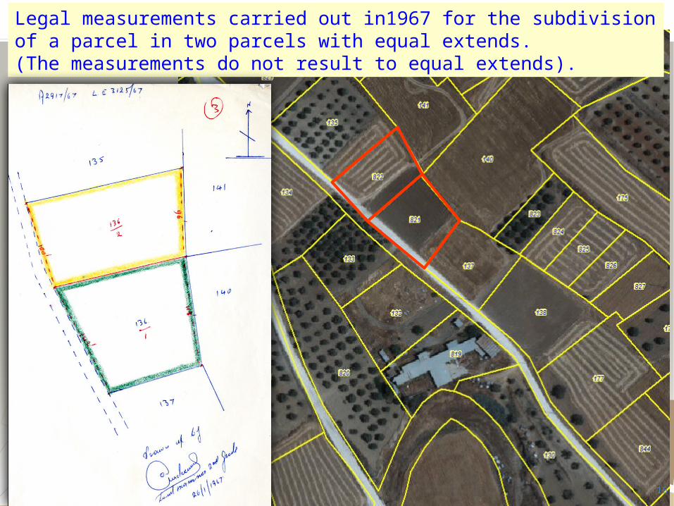
Conference and Plenary Meeting of the PCC in Cyprus 260 plans 1:1000 (LTM)
750 plans 1:2000 (LTM) 906 plans 1:2500 (cassini-unsound) 211 plans 1:500 (cassini) 615 plans 1:1000 (cassini)3383 plans 1:2500 (cassini)1590 plans 1:5000 (cassini) 830 plans 1:1250 (cassini)
CYPRUS CADASTRAL MAPOctober 2012
1,579,000 parcels
21Dr Elikkos Elia

Conference and Plenary Meeting of the PCC in Cyprus
22
Systematic and Sporadic Resurvey

Conference and Plenary Meeting of the PCC in Cyprus
Dr Elikkos Elia 23
Private Sector Involvement in
Cadastral Surveys in Cyprus
Conference and Plenary Meeting of the PCC in Cyprus
Dr Elikkos Elia 24
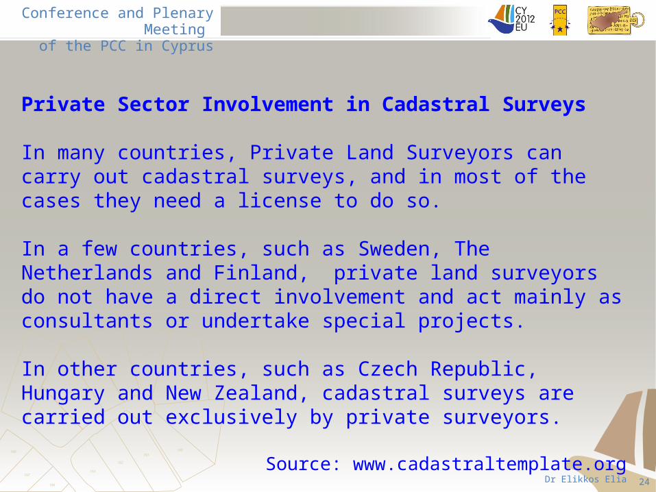
Private Sector Involvement in Cadastral Surveys
In many countries, Private Land Surveyors can carry out cadastral surveys, and in most of the cases they need a license to do so.
In a few countries, such as Sweden, The Netherlands and Finland, private land surveyors do not have a direct involvement and act mainly as consultants or undertake special projects.
In other countries, such as Czech Republic, Hungary and New Zealand, cadastral surveys are carried out exclusively by private surveyors.
Source: www.cadastraltemplate.org

Conference and Plenary Meeting of the PCC in Cyprus
Dr Elikkos Elia 25
Germany* 23,000
Poland 16,700
Australia 3,500
Bulgaria 2,333
Hungary 1,700
Lithuania 1,516
Czech Republic 1,500
Belgium* 950
Sweden, New Zealand* 600
Switzerland* 500
Finland 400
Denmark, The Netherlands 300
Latvia 173
Cyprus 100
Number of Professional Land Surveyors
Source: www.cadastraltemplate.org - FIG
(The proportion of the time that they actually commit for cadastral matters vary from 40% to 100%)
* The report submitted in 2003

Conference and Plenary Meeting of the PCC in Cyprus
Cyprus University of TechnologyDepartment of Civil Engineering & Geomatics(…expected in 2013….)
National Technical University of AthensSchool of Rural and Surveying Engineering
Aristotle University of ThessalonikiSchool of Rural and Surveying Engineering
Budapest University of Technology & EconomicsFaculty of Civil Engineering
The surveyors in Cyprus have been graduated mainly from the following Universities:
26

Conference and Plenary Meeting of the PCC in Cyprus
Dr Elikkos Elia 27
Private Sector Involvement in Cadastral Surveys in Cyprus
In Cyprus, the involvement of private land surveyors began in 1992,
for a specific type of cadastral applications regarding land divisions
and horizontal (strata) divisions. The demarcation of the external
boundary for these applications was carried out at that time by
governmental surveyors.
A small number of applications were carried out by private
surveyors until 2007 when the Cadastral Survey Law was enforced.

Conference and Plenary Meeting of the PCC in Cyprus
Dr Elikkos Elia 28
Cadastral Surveys Law
In 2006, the Cyprus Cadastral Survey Council was established
and the first Cadastral Surveyors Register was created.
The Cadastral Surveys Law was actually enforced on the
2.2.2007.

Conference and Plenary Meeting of the PCC in Cyprus
Dr Elikkos Elia 29
Becoming a Cadastral Surveyor…
Any person may be included in the Cadastral Surveyors Register if he/she:
1. is a member of the Scientific Technical Chamber of Cyprus in the Rural and Surveying Engineering Branch,
2. has at least one year experience in the field of cadastral surveying.
Today, 87 Private Surveyors and 14 Civil Servants are registered as Cadastral Surveyors.

Conference and Plenary Meeting of the PCC in Cyprus
Dr Elikkos Elia 30
Land & Surveys Dept.
Land Consolidation Dept.
Other Governm. Depts
Private Cadastral Surveyors
Other private works
Current working status of Professional
Surveyors in Cyprus

Conference and Plenary Meeting of the PCC in Cyprus
Dr Elikkos Elia 31
Applicants to any District Land Office of the Land and Surveys Department, requiring cadastral field surveys, have the option to choose between a governmental or a private licensed surveyor. Such works include the field surveys for:
• land demarcations
• vertical or horizontal (strata) property divisions
• boundary readjustments
• boundary amalgamations
• street widening and building or other property registrations.
Cadastral field surveys carried out by private surveyors

Conference and Plenary Meeting of the PCC in Cyprus
Dr Elikkos Elia 32
In any case, whether the work is undertaken by a private or a
governmental surveyor, the applicant has to pay the required fee
to the Land and Surveys Department. If the applicant chooses to
proceed with a private licensed surveyor, the applicant has to
personally agree with the Private Surveyor for an additional fee
and sign a contract provided by the Cyprus Scientific and
Technical Chamber. In all cases the field work is checked by the
DLS staff who has also the responsibility to update the cadastral
plan and the databases of the Land Information System.
Cadastral field surveys carried out by private surveyors

Conference and Plenary Meeting of the PCC in Cyprus
Dr Elikkos Elia 33
Application Undertaken by DLS Field work by private licensed surveyor
Land demarcationUp to 6 BTPsFrom 7 to 12 BTPsMore than 13 BTPs
€50 for each BTP€30 for each BTP€20 for each BTP
€15 for each BTP€10 for each BTP €6 for each BTP
Land parcel division or boundary readjustment
€110 for each new created parcel
€35 for each new created parcel
Building (strata) division
€100 for each new created unit
€30 for each new created unit
Boundary dispute €160 for each involved parcel
Not carried out by private surveyors
Examples of Fees Paid to the DLS

Conference and Plenary Meeting of the PCC in Cyprus
Dr Elikkos Elia 34
Cyprus Positioning System (CYPOS)
Seven permanent GNSS network stations.
Users: DLS, private surveyors, other engineers, departments, organizations and citizens.
Annual fee = €200+VAT
The cadastral field surveying works are supported today by the Cyprus Positioning System.

Conference and Plenary Meeting of the PCC in Cyprus
Dr Elikkos Elia 35
2006 2007 2008 2009 2010 2011 20120
2000
4000
6000
8000
10000
12000
14000
Undertaken by the DLS Field work by Private Surveyors
Applications undertaken by governmental & private surveyors

Conference and Plenary Meeting of the PCC in Cyprus
Dr Elikkos Elia 36
DLS 97%
Private Surveyors
3%
Applications carried out by governmental and private surveyors in 2006
Total:11.234DLS: 10.869
Private: 365

Conference and Plenary Meeting of the PCC in Cyprus
Dr Elikkos Elia 37
DLS62%
Private38%
Total: 9.156DLS: 5.688
Private: 3.488
Applications carried out by governmental and private surveyors in 2011

Conference and Plenary Meeting of the PCC in Cyprus
Dr Elikkos Elia38
CONCLUSION
The resurvey project aims to prepare new digital cadastral plans with high accuracy and reliability, providing a fundamental infrastructure to the databases of the Land Information System, the Cadastre and to the broader Land Administration System. In the areas where the resurvey project was completed, governmental or private surveyors can carry out cadastral surveys rapidly, efficiently and without ambiguities. It is recognized that more effort should be placed to accelerate and finish this project.
The private surveyors have an important and active role in the field of cadastral surveying in Cyprus. Today the citizens have the option to choose between the DLS or a private licensed surveyor to carry out a cadastral survey. With the completion of the resurvey project, it will be easier for the Government to pass all cadastral field works to the private sector.
![No. 6288. LAND SURVEYORS ACT 1958.1958. Land Surveyors. No. 6288 837 No. 6288. LAND SURVEYORS ACT 1958. An Act to consolidate the Law relating to Surveyors. [30th September, 1958.]](https://img.pdfslide.us/doc/110x75/5e94498d234c4b210e568874/no-6288-land-surveyors-act-1958-1958-land-surveyors-no-6288-837-no-6288.jpg)